Abstract
Excluding windblown dust, unpaved road dust PM 10 emissions in the US EPA's 2002 National Emission Inventory account for more than half of all PM 10 emissions in the arid states of the western U.S. (i.e., CA, AZ, NV, NM, and TX). Despite the large size of the source, substantial uncertainty is associated with both the vehicle activity (i.e., number of kilometers traveled at a particular speed) and the emission factors (i.e., grams of PM 10 per kilometer traveled). In this study, emission factors were measured using the flux tower method for both tracked and wheeled military vehicles at three military bases in the Western U.S. Test vehicle weights ranged from 2400 kg to 60,000 kg. Results from both previously published and unpublished field studies are combined to link emission factors to three related variables: soil type, vehicle momentum, and tred type (i.e., tire or track). Current emission factor models in US EPA's AP-42 Emission Factor Compendium do not factor both speed and weight into unpaved road emission factor calculations. Tracked vehicle emission factors from Ft. Carson, CO, and Ft. Bliss, TX were related to vehicle momentum (speed ∗ mass) with ratios ranging from 0.004–0.006 (g-PM vkt− 1)/(kg m s− 1). For similar vehicle momentum, wheeled vehicles emitted approximately 2 to 4 times more PM 10 than tracked vehicles. At Yakima, WA, tracked vehicle PM 10 emission factors were substantially higher (0.38 (g-PM vkt− 1)/(kg m s− 1)) due to the unique volcanic ash soil characteristics (48% silt). Results from PI-SWERL, a portable wind tunnel surrogate, are presented to assess its utility to predict unpaved road dust emissions without the deployment of flux tower systems. PI-SWERL showed only a factor of 6 variation between sites in comparison with the 60-fold variation as measured by the flux towers.
1. INTRODUCTION
Particulate Matter (PM) emission is a critical problem for the Department of Defense (DoD). PM emitted during DoD testing and training activities threatens the safety and respiratory health of military personnel and can impact the health of urban populations encroaching on military installations. Moreover, new regulations protecting visibility at Class I national parks, forests, and wilderness areas mandate reductions in PM emissions and its chemical precursors over the next 60 years. Since many military installations are located near Class I areas, these regulations are likely to affect training activities in coming years. Military activities create unique dust emission sources not encountered in the civilian environment and which have not been accurately characterized and quantified.
Vehicles traveling on paved and unpaved roads emit particles as tires entrain particles. On paved roads, a finite reservoir of particles exists for resuspension. With high traffic volumes, paved road surfaces reach equilibrium with the rate of emissions converging on the rate of material deposition to the roads (CitationHussein et al. 2008). Studies have found that dust emission rates depend on the fine particle content of the road (CitationCowherd et al. 1990; CitationMRI 2001), soil moisture content, vehicle speed (CitationNicholson et al. 1989; CitationEtyemezian et al. 2003a, Citationb), and vehicle weight (CitationUS EPA 1996, Citation2003; CitationMRI 2001). A different mechanism applies for unpaved roads where there is an effectively infinite reservoir of material to be suspended into the air (CitationGillies et al. 2005a, Citationb). Gillies et al. (Citation2005a, Citationb) found unpaved PM10 emissions are linearly correlated with both vehicle speed and mass.
For the movement of heavy vehicles on haul roads the CitationUS EPA (2003) emission factor neglects the effect of vehicle speed. The equations used for vehicles traveling at industrial sites has the form:
Limited research has been conducted to analyze the PM emissions from tracked vehicle operation. CitationDornbusch et al. (1988) assembled dust emission measurements from tracked vehicle tests and derived a power law equation linking dust emissions to vehicle weight, tread area, speed, and silt loading. The source of these data was unavailable in their published report but they relied on integrated filter samples for the emission factor calculations. Filter sampling greatly limits the utility of such datasets since substantial resources are required to extract trends related to vehicle operating parameters.
CitationGoossens and Buck (2009) conducted controlled off road recreational vehicle emission studies on unpaved road surfaces in Southern Nevada. They found that dust emission strength was linked to soil type with emissions increasing from sandy areas and drainages, to mixed terrain, with the highest emissions from silty areas.
This article combines the already published work of CitationGillies et al. (2005a) that describes off road wheeled vehicle emission factors collected at Ft. Bliss, Texas with new data sets including tracked vehicle PM10 emission factors from Yakima Training Center, Washington and Ft. Carson, Colorado. In addition, results from PI-SWERL, a portable wind tunnel surrogate, are presented to evaluate its utility to predict unpaved road dust emissions without the deployment of flux tower systems.
2. MEASUREMENT METHODS
2.1. Flux Towers
Emission factors from military vehicles were measured using an array of DustTrak 8520 (TSI Incorporated; Shoreview, MN) particle sensors mounted on towers downwind of the test surfaces. Emission factor flux calculations are performed by assuming each DustTrak represents the average airborne dust concentration over a fixed interval on the tower. The lowest sensor represents the air passing the tower between the ground and halfway between the lowest and second lowest sensors. The second lowest sensor represents the height from halfway between first and second sensor to halfway between the second and third sensor and so on up the tower. The top sensor represents the heights from halfway between the highest sensor and the next highest sensor to the same distance above the top sensor.
The instrumentation used to measure the dust emissions in situ consisted of three of the DRI Flux Towers (CitationGillies et al. 2005a, Citation2007). The master tower consists of five paired PM10 and PM2.5 samplers collocated with cup anemometers. A typical set up was for the master tower to be positioned half way between the starting and ending driving points of the unimproved tank trail. The satellite towers each hold paired PM10 and PM2.5 samplers to measure the vertical concentration gradient of particulates at locations approximately 40 m either side of the master tower. Satellite towers were positioned also based on the environmental conditions of the day, particularly wind direction. Typically, one tower was placed 30 to 50 m down the road on the same side as the master tower with the other placed on the opposite side of the road in line with the master tower. This was done for two reasons. It would (1) allow for the continued measurement of emissions should the wind reverse directions, and (2) it allowed for measurement of background dust concentrations upwind of the road.
The vertical concentration data are combined with the wind speed and wind direction data to calculate an emission flux of grams of PM10 or PM2.5 per vehicle kilometer traveled. The emission flux is calculated using the same method as CitationGillies et al. (2005a) to calculate emissions of dust created by wheeled vehicles traveling on an unpaved road. The equation used to define the Emission Factor(EF) is:
CitationVeranth et al. (2003) present an alternative method of calculating dust flux by first fitting physically plausible interpolation functions to the field measurements made at discrete heights and then calculating the flux by integrating the product of the wind speed and dust concentration interpolation functions over the inferred plume height. For our results, we have elected to calculate emission factors as a “step-wise” integration of particle fluxes without assumptions about plume height. Results may vary depending on the method applied.
2.2. Laboratory Resuspension Analyses
The flux tower relies on the TSI DustTrak 8520 to infer 1 Hz concentrations of PM10 and PM2.5. This tower also includes a TEOM 1400a instrument (Thermo Fisher Scientific Inc., Waltham, MA) to compare the light scattering measurement method of the DustTrak with a mass-based measurement method. The TEOM is a federal equivalent method for measuring PM10; however it is not well suited for single day field deployment. The TEOM can require three hours to stabilize and perform an auto-calibration. In addition, the time resolution of PM10 measurements is typically 10 minutes, limiting the number of data points for comparison to the light scattering instrumentation. Field comparisons between DustTraks and TEOM were compromised when extreme plumes with concentrations > 150 mg m− 3 would invalidate the DustTrak sampler data and preclude comparison with the 10 min integrated TEOM measurement.
To link the light scattering measurements with gravimetric filter based measurements, a dust resuspension chamber was assembled in the laboratory similar to that developed by CitationChow et al. (1994). Bulk samples of unpaved road surface material were sieved to separate the silt size fraction (particles less than 75 μ m that pass through a #200 sieve). Approximately 1 g of silt was loaded into an Erlenmeyer flask that was connected to a compressed air source and a sampling plenum. A continuous stream of compressed air was blown into the flask to suspend the silt, and force it into the sampling plenum. Air in the plenum was sampled with two DustTraks and by filters that had PM10 and PM2.5 impaction plates incorporated into the sampling line in front of the filter holders. The filter sampling duration lasted approximately 5 min to collect a target mass of 1 mg PM on the filters. Filters were then weighed and mass concentrations were compared with the average DustTrak concentrations over the filter sampling interval to derive a calibration relationship between the light-scattering measurement for PM concentration and the Gravimetric-derived dust concentration, for the same source dust as that which impacted the dust samplers in the field experiments.
2.3. PI-SWERL
The DRI PI-SWERL (CitationEtyemezian et al. 2007; CitationSweeney et al. 2008; CitationKavouras et al. 2009) was used to measure emission potential of the unpaved roads before and after vehicle testing at the Ft. Carson and Yakima Training Center locations. The PI-SWERL is a battery powered instrument that creates a shear stress on the surface within a cylindrical enclosure by a rotating annular blade within close proximity of the surface. It measures the PM10 concentration (C, mg m− 3) at an outlet with a DustTrak that records at 1 Hz while a blower vents clean air through the PI-SWERL at a constant rate (F, m3 s− 1). An emission flux (E) in mg m2 s− 1 or amount of PM10 per area per second can be calculated as:
3. SAMPLING LOCATIONS
Emission factors from 10 types of military off road vehicles were measured at three locations between 2002 and 2008. Images of each vehicle type are shown in Supplemental Data Figure S1. The wheeled vehicles range in mass from 2400 kg for the HMMWW light truck to 20,000 kg for the HEMTT cargo truck. Tracked vehicles tested ranged from 10,000 kg for the M113 armored personnel carrier to 60,000 kg for the M1A1 tank. The three sampling locations at Ft. Bliss, TX, Yakima Training Center, WA, and Ft. Carson, CO are described along with the unique sampling parameters from each field study. At each site, test sections were on straight roads with no visible turns.
3.1. Ft. Bliss (El Paso, TX), April 11–17, 2002
Experiments at Ft. Bliss, TX, measured emission factors for each of the four wheeled vehicle types shown in Supplemental Data Figure S1 as well as an M88 Hercules tracked vehicle. Gillies et al. (Citation2005a, Citationb) describe these experimental results in detail. The Ft. Bliss measurement site is representative of a disturbed desert surface in the Chihuahuan Desert. The vegetation cover was less than 10% (CitationGillies et al. 2005a) and during the testing the moisture content of the road surface materials was extremely dry (< 1%).
Soil size analyses by the U.S. Natural Resources Conservation Service Soil Survey Geographic (SSURGO) Database categorize soil as percent sand (2000–50 μm), silt (50–2 μm), and clay (< 2 μm). The AP-42 dry sieve method (CitationUS EPA, 2009) separates material so that “siltfraction” is defined as the relative mass of material less than 6000 μm that passes through a #200 sieve (< 75 μm). In this study, the SSURGO silt and clay fractions were combined for use as “silt” in AP-42 emission equations. The soil type at the Ft. Bliss test site (N 31.8833 degrees, W 106.3693 degrees) was Hueco loamy fine sand (79% Sand, 16% Silt, and 5% Clay) (CitationSSURGO, 2009). CitationGillies et al. (2005) directly measured silt content at this site ranging from 4% to 7%. For consistency with the data from the Yakima and Ft. Carson, the SSURGO datasets are used to calculate AP-42 Emission Factors. The unpaved road surface was flat and three towers were erected in a line perpendicular to the road at 7 m, 50 m, and 100 m from the road centerline. For the Ft. Bliss experiments, 1 s PM10 concentrations remained below the 150 mg m− 3 upper reportable limit as specified by the manufacturer. The PI-SWERL system had not been developed at this time precluding the collection of directly comparable wind erodibility measurements from the road surface. This study did not examine PM2.5 emission factors.
During these experiments, bulk samples were not collected for the purpose or resuspension analysis. Relevant ratios of gravimetric PM10 to DustTrak PM10 were measured in situ on one of the flux towers. Ratios of DustTrak PM10 to PM2.5 were measured onboard the TRAKER vehicle (CitationKuhns et al. 2005) for the same stretch of road that the emissions were generated from by the passage of the wheeled test vehicles. Both ratios are reported in for comparison with resuspension results from Yakima and Ft. Carson sites.
TABLE 1 Ratios of PM concentration based on size (PM10 and PM2.5) and measurement method (gravimetric and DustTrak) from bulk sample resuspension analysis. Uncertainties are standard deviations of the ratios. The number in parenthesis represents the number of replicates used to calculate the average
3.2. Yakima Training Center, WA August 21–29, 2006
Tracked vehicle emission factors from the M113, Bradley M2, and the M1A1 vehicles were measured at the Yakima Training Center and reported for the first time here. Soils at that site are heavily influenced by volcanic ash from the nearby Mt. Saint Helens. The soil types at the test site (N 46.6633 degrees, W 120.3580 degrees) were Selah silt loam and Benwy silt loam (35% Sand, 48% Silt, and 17% Clay) (CitationSSURGO, 2009). Direct measurements of the unpaved tank trail indicated a soil with 70%–90% silt, with very low moisture content (< 1%). The vegetation at the time of the measurements was scattered low shrubs with grasses. The unpaved road was oriented in a north-south direction and had a grade of ∼ 2 degrees uphill to the south. Two towers were erected at this location with tower one (master, 9 m height) and tower two (15 m height) placed on the east side of the unpaved road. Tower one (at 16 m from the road) was equipped with five pairs of DustTraks (10 total) fitted with both PM10 and PM2.5 inlets. Tower two (30 m from the road) had 7 DTs fitted with PM10 inlets. The third tower (15 m height) was located on the west side of the road 30 m from the road centerline. On Tower 1, paired PM10 and PM2.5 DustTrak instruments were located at 0.7, 2.1, 3.4, 6.4, and 9.8 m above ground level (agl). On Tower 2, PM10 DustTrak instruments were located at 1.7, 2.3, 3.6, 6.0, 9.8, 11.6, and 15.2 m agl.
Additional details of the tower configuration at Yakima are presented in CitationGillies et al. (2006) and CitationHashmonay et al. (2009). The following criteria were used for validation of emission factor measurements ().
TABLE 2 Flux calculation data recovery statistics from the Yakima and Ft. Carson vehicle dust flux experiments
3.2.1. Instrument Acquisition
On 2006/08/29, data acquisition faults associated with instrument power failures invalidated two vehicle passes from the Tower 1 PM10 data set and three vehicle passes from Tower 2 PM10 data set.
3.2.2. Plume Height
Usually under low wind conditions, the top DustTrak on a tower would report PM concentrations above 1 mg m− 3 as the plume height exceeded the tower height. Under these conditions, the flux measurement was invalidated since it was impossible to define the vertical extent of the plume. On the top PM10 DustTrak on Tower 1, seven vehicle passes were invalidated. On Tower 2, nine vehicle passes were invalidated.
3.2.3. Wind Direction
Vehicle pass fluxes were calculated only when the wind vectors were within 45 degrees of perpendicular to the road direction. Out of 131 vehicle passes, six were invalidated due to wind direction being outside of the ± 45 degree sector.
3.2.4. Detectable Limits
Unlike in previous studies (e.g., CitationGillies et al. 2005), plume concentrations at the test site frequently exceeded the 150 mg m− 3 maximum detection limit of the dust sensors (see image on Supplemental Data Figure S2). Above these concentrations, the dust sensor has a nonlinear response that is difficult to relate to filter based measurements with confidence. Vehicle passes where one sensor on the tower exceeded 150 mg m− 3 for 1 s were invalidated. This factor invalidated the largest number of vehicle passes: 118 for PM10 on Tower 1, 73 for PM2.5 on Tower 1, and 92 for PM10 on Tower 2.
After applying the criteria listed above, the data recovery percentages were 8% for PM10 on Tower 1, 41% for PM2.5 on Tower 1, and 26% for PM10 on Tower 2. Interpreting only the valid emission factor results from this study would negatively bias the summary since the largest emission factors are preferentially invalidated. In order to glean as much useful information from the study as possible, a flux calculation quality scheme was devised.
3.2.5. Class A: Highest Quality Flux Calculations
These data passed all of the criteria listed above.
3.2.6. Class B: PM 10 Flux Calculations Based on Collocated PM2.5 Measurements
Since PM2.5 is a subset of PM10, the maximum concentration of PM2.5 for each vehicle pass has the potential to be valid when the maximum PM10 is greater than 150 mg m− 3. Averaged values of PM10/PM2.5 for each vehicle pass when all values are less than 150 mg m− 3 were calculated for each position on Tower 1. These values were multiplied by the pass average PM2.5 concentration for each pass to calculate PM10 concentrations when the maximum value of the collocated PM10 concentration exceeded 150 mg m− 3. The resulting value of PM10 (inferred from collocated PM2.5) was then used to calculate the PM10 Flux past the tower. Class B has higher uncertainty than Class A, since the relationship between PM10 and PM2.5 can change. This uncertainty should be small since the source of the road dust does not change over time.
3.2.7. Class C: PM 10 Flux Calculated from Next Highest Dust Sensor on Tower
For many vehicle passes on Tower 1, even the maximum PM2.5 concentration was greater than 150 mg/m3. For these cases, we used data from the DustTrak at the next highest level on the tower to infer the concentration at the lower level. Using the set of vehicle passes where none of the maximum PM2.5concentrations exceed 150 mg m− 3, average ratios of neighboring PM2.5 dust sensors were calculated (i.e., lower concentration/upper concentration). For vehicle passes where the maximum PM2.5 concentrations exceed 150 mg m− 3, the valid PM2.5 concentrations from the sensor above were multiplied by the ratio. In turn, the calculated average PM2.5 concentration was multiplied by the ratio described for Class B to infer the pass averaged PM10 concentration. When more than one PM2.5 sensor exceeded the maximum value criterion, PM10 concentrations were estimated by sequentially propagating the concentrations of the lowest valid PM2.5 measurement down the tower. This method compounds the error introduced in the Class B calculation and is prone to additional error associated with variations in the average plume profile passing the tower. Consequently, Class C flux calculations are assumed to have higher uncertainty than Class B.
For Tower 2, only dust sensors with PM10 inlets were deployed. Class C fluxes were calculated using the ratio of the PM10 concentrations with values from the PM10 sensor mounted above the over-ranged sensor. shows the number of vehicle passes that fall within each data quality class. All data from Classes A, B, and C are presented in the Results section.
3.2.8. PI-SWERL Experiments, Yakima Training Center
The PI-SWERL was operated on the unpaved test road at the Yakima training Center on 8/24/06, midway through the testing period. Thus PI-SWERL measurements at Yakima Training Center correspond to thoroughly disturbed roadway conditions. Five replicate measurements were completed across the width of the unpaved road. The measurement cycle comprised a series of step increases in the rate of rotation of the PI-SWERL annular blade as described in CitationEtyemezian et al. (2007). Each RPM step was held for 90 seconds. The test cycle consisted of: (1) a 120 s clean air flush, (2) a step increase to 600 RPM, (3) a step increase to 900 RPM, (4) a step increase to 1200 RPM, (5) a step increase to 1800 RPM, (6) a step increase to 2400 RPM, and (7) turn off motor and clean air flush for 90 s.
3.3. Ft. Carson (Colorado Springs, CO), September 16–19, 2008
Vehicle generated dust emissions were measured at two unpaved road locations at Ft. Carson, CO. Tracked vehicles tested included a M270 Multiple Launch Rocket System (MLRS), a M88 Hercules Recovery Vehicle, and a M113 Troop Carrier, generally representing the range of weight and size for the Department of Defense's tracked vehicle fleet. Due to maintenance issues, the M88 was only tested at the first site. An M977 HEMMT wheeled vehicle was also tested at the second site. The tower configurations for the two Ft. Carson sites are shown in the Supplemental Data Figure S3. At both sites, on the master tower, paired PM10 and PM2.5 DustTrak instruments were located at 1.7, 2.6, 4.0, 6.5, and 9.1 m above ground level (agl). On the satellite towers, PM10 DustTrak instruments were located at 1.7, 2.7, 5.1, 8.7, and 14.2 m agl.
As with the Yakima Training Center experiments, actual vehicle speeds were recorded using a vehicle-mounted GPS unit. After two passes at the same speed, the vehicle speed was increased incrementally to the maximum and then decreased incrementally to the slowest speed. Vehicles paused between passes to allow the plume to clear all towers and sensing instruments. Tests were conducted on level roads at speeds of: 2.2 m s− 1 (5 mph), 4.47 m s− 1 (10 mph), 6.7 m s− 1 (15 mph), 8.9 m s− 1 (20 mph), and approximately 11.2 m s− 1 (25 mph).
The soil type of the first unpaved road site (N 38.6469 degrees, W 104.7861 degrees) was Heldt clay-loam (34% Sand, 32% Silt, and 34% Clay) and the second site (N 38.7088 degrees, W 104.7858 degrees) was Razor-Midway complex clay-loam (34% Sand, 32% Silt, and 34% Clay) (CitationSSURGO, 2009). Emission factors at this site were significantly lower than at the Yakima site. The unpaved travel surfaces at Ft. Carson did not have a deep disturbed layer of sediment as did the test surface at Yakima Training Center. All dust sensor measurements from the flux towers at both Ft. Carson locations were below the 150 mg m− 3 instrument upper limit. Emission factor data recovery at Ft. Carson was 171 out of 225 (76%) for PM10 and 39 out of 75 (52%) for PM2.5 at Site 1 and 84 out of 134 (62%) for PM10 and 0 out of 67 (0%) for PM2.5 at Site 2. Reasons for less than 100% data recovery include wind direction outside of the allowed range, wind speed too slow, and instrument failure. Additional study details are presented by CitationGillies et al. (2008).
3.3.1. PI-SWERL Experiments, Ft. Carson
The PI-SWERL was operated at the two unpaved roads in Ft. Carson, Colorado. At the first unpaved road (Site 1), the PI-SWERL was operated before any tracked vehicles traversed the road (9/16/08), after the heaviest tracked vehicle traversed the road for emissions measurements (9/16/08), and after all three tracked vehicles had traversed the roads (9/17/08). At the second unpaved road site, the PI-SWERL was operated before any tracked vehicles traversed the road (9/18/08) and after all three tracked vehicles and a HEMMT traversed the road for emission testing (9/19/08). At each of these measurement intervals a minimum of six replicate measurements was completed.
For all measurements, a hybrid ramp/step measurement cycle was used consisting of: (1) a 60 s clean air flush, (2) a sharp acceleration to 500 RPM, (3) a 60 s linear ramp to 2000 RPM, (3) maintain 2000 RPM for 60 s, (4) a 60 s ramp to 3000 RPM, (5) maintain 3000 RPM for 90 s, (6) a 60 s ramp to 4000 RPM, (7) maintain 4000 RPM for 90 s, and (8) turn off motor and clean air flush for 60 s.
4. RESULTS
Average ratios of filterable PM10 mass to DustTrak PM10 mass were used to adjust all emission factors to a gravimetric basis. The ratios of gravimetric and DustTrak PM10 and PM2.5 from the three test regions are summarized in .
The variation of PM10 emission factor (EF) magnitude based on vehicle speed and location is shown in . Each point represents the average emission factor of multiple passes measured by one or more towers at each site. The error bars in the figure are the standard error (i.e., standard deviation divided by the square root of the number of replicate samples) of the mean that describes how well the mean is known based on repeated measurements. The average EF coefficient of variation (i.e., standard deviation/mean) for a site/vehicle/speed group was 0.7 emphasizing the need to collect replicate measurements (average n = 10) to better define the underlying trends with speed or weight. The upper two panels () show the relationship between vehicle speed and emission factors measured at Ft. Bliss and Ft. Carson. The horizontal lines on the upper left panel show the AP-42 wheeled vehicle emission factors based on silt content and vehicle weight. The AP-42 model results are in the same range as the measured data however the omission of speed in the model can result in biases up to a factor of 3 in predicted PM10 emissions.
FIG. 1 Comparison of gravimetric PM10 emission factors versus vehicle speed from Ft. Bliss, Ft. Carson, and Yakima.
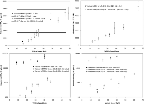
For the same vehicles, emission factors and their increasing trend with vehicle speed are nearly equivalent (< 30% difference) between the two sites. In contrast, the lower two panels show a comparison of similar weight tracked vehicle emission factors between Ft. Carson and Yakima Training Center. These panels are shown with a logarithmic y-axis to show that emission factors at Yakima Training Center are approximately two orders of magnitude higher than at Ft. Carson due to the highly emissive soils at the Yakima Training Center (). All sites show a strong correlation between gravimetric PM10 emission factors and vehicle speed for the same vehicle. The trend is less visible on the lower panels due to the logarithmic axis.
TABLE 3 Summary of surface material texture, emission factors, and cumulative PI-SWERL emissions for four test locations. Uncertainties are standard deviations of the emission factors. The number in parenthesis represents the number of replicate samples in the average. PI-SWERL measurements have different emission factor units and, like the silt content, are shown to provide a relative comparison
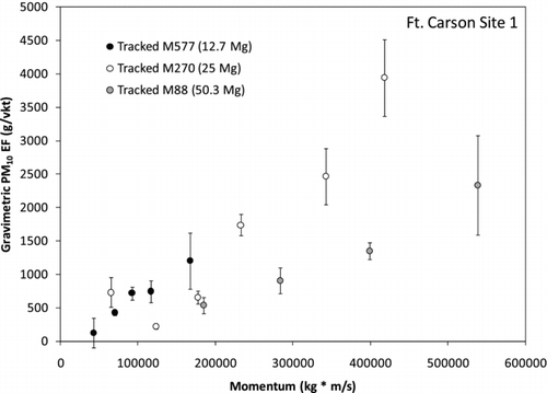
In agreement with CitationGillies et al. (2005) wheeled vehicle results, PM emissions from both Yakima Training Center and Ft. Carson are correlated with vehicle momentum (i.e., velocity times mass). The relationship between tracked vehicle momentum and gravimetric PM10 emission factor for three different vehicles is shown in . The central grouping of the data supports the parameterization of emissions factors being proportional to vehicle momentum.
FIG. 2 Comparison of tracked vehicle PM10 emission factors versus vehicle momentum for three different vehicles.
The relationship between tracked and wheeled emission factors versus emissions from both the Ft. Bliss and Ft. Carson sites are shown in . At both locations, wheeled vehicles emit ∼ 2 times more PM10 than tracked vehicles for the same momentum. One hypothesis is that this effect may be due to the fact that the tracked vehicle spreads its weight over two treads whereas a wheeled vehicle has four or more wheels. Wheeled vehicles emit dust in front of or behind the point where the tire is in contact with the surface. The image of a tracked vehicle on an unpaved road (Supplemental Data ) shows that dust emissions occur both at the front and rear of the tank as the tread is first contacting and then separating from the ground. Each element (tread or tire) emits dust when it first makes contact with the ground and when it detaches from the ground. A wheeled vehicle has at least twice as many contact points that serve as sources for dust emissions.
FIG. 3 Comparison of tracked and wheeled vehicle DustTrak emission factors versus vehicle momentum operating at the same locations.
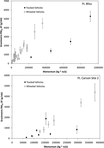
All emission factors from all four sites (Ft. Bliss, Yakima Training Center, and Ft. Carson 1 and 2) were grouped based on location and tread type (i.e., wheel or track). The average ratios of emission factor to momentum were calculated for each group and are presented in along with the standard deviation and number of tower flux measurements used to calculate the average. The tracked vehicle emission factor to momentum ratios are generally consistent at Ft. Bliss and both Ft. Carson sites ranging from 0.004 to 0.006 (g-PM vkt− 1)/(kg m s− 1), but are a factor of 60 less than the values observed in Yakima at 0.38 (g-PM vkt− 1)/(kg m s− 1). These results show that the location and the soil type of the area in question are critical factors that must be considered to accurately estimate tracked and wheeled unpaved road emissions.
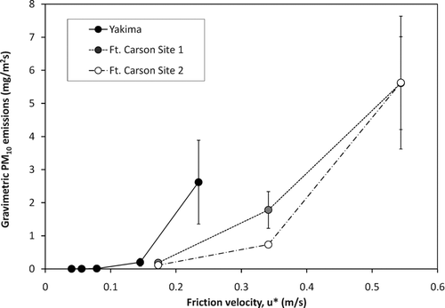
PI-SWERL was deployed at Yakima and Ft. Carson in hopes that the measurement would serve as a surrogate to infer the variation of emission factor with site characteristics. The PI-SWERL measures the potential for a surface to emit PM based on wind erosion (CitationEtyemezian et al. 2007). The mechanism of saltation induced particle entrainment is quite different from the interaction of a vehicle tire or track with a road surface. Depending on the surface type, the tire or tread may penetrate through or deform the road surface and suspend material from deeper layers than are available to wind erosion.
PI-SWERL measurements were collected on the same roads measured with the flux tower and are compared with the road dust emission factors in . PI-SWERL measures the concentration of particles suspended from a surface while increasing the shear stress (τ N m− 2 = ρ a u∗ 2, where ρ a is air density, kg m− 3) applied to the surface. A modified test cycle was required for testing the Yakima soils due to the high dust emissivity. The test cycles at both Yakima Training Center and Ft. Carson overlapped between u∗ = 0.17 m s− 1 and 0.23 m s− 1 (). For comparison purposes, all PI-SWERL PM10 emissions were interpolated to u∗ = 0.2 m s− 1. A comparison of cumulative PI-SWERL emissions from Yakima and Ft. Carson is shown in . PI-SWERL emissions are ∼ 6 times larger at Yakima than at Ft. Carson for the same shear velocity, much less than the change in emission factors that occurred for vehicles with similar momentum. A larger data set is needed to evaluate if these two measurement methods scale similarly, which if proved could provide a means to evaluate emission potential from unpaved roads created by vehicle travel.
FIG. 4 PI-SWERL P10 emissions versus friction velocity from Yakima Training Center and Ft. Carson unpaved roads.
5. CONCLUSIONS
Unpaved road PM10 emissions factors are systematically dependent on vehicle propulsion type (i.e., wheel or track), momentum, and the textural qualities of the surface as well as the depth of the disturbed surface layer. Texture of the unpaved road surface (i.e., % sand, silt, and clay) affects the amount of available dust-sized particles and the depth of the disturbed layer affects how much material can be forced to the sides of the tracks during compression and lifting from the surface by the track as it turns upward at the rear of the vehicle. At the two sites tested, flux tower-derived emission factors were a factor of ∼ 60 higher at Yakima than at Ft. Carson, whereas PI-SWERL cumulative PM10 emissions larger by only a factor of ∼ 6. The emissions relationships (momentum versus dust emission) presented here will provide the basis for developing emission inventory estimates of PM10 and PM2.5 from Department of Defense testing and training activities for the military bases where the measurements were collected. In light of these results, the AP-42 unpaved road emission factors may be biased high or low by a factor of 3 if both speed and mass are not simultaneously factored into the calculation.
Results could be extended with caution to other locations with similar soil textures, but broad applicability of the momentum versus emission relationships will require that an effective scalar be established to account for the emission properties of the surface from which the dust is emitted.
PI-SWERL is an effective and easy method to use for inferring potential for dust emissions caused by wind erosion processes. The physical mechanism of entraining dust via a solid tire or track type tread appears to be sufficiently different from wind entrainment that PI-SWERL may have limited value as a surrogate to predict road dust emission potential. Other measurement systems that use a tire to physically disturb the soil such as TRAKER (CitationEtyemezian et al. 2003; CitationKuhns et al. 2005) may provide a more accurate means of comparing emissions potential between locations.
uast_a_452148_sup_12427642.zip
Download Zip (2.1 MB)We would like to acknowledge the logistical and financial support provided by the National Guard MATES facilities at Yakima Training Center, Yakima, Washington and Ft. Carson, Colorado. Special thanks to the MATES personnel who operated the vehicles for us as well as their flexibility in accommodating our demands. We would also like to thank Yakima Training Center and Ft. Carson for hosting our field measurement campaigns and the SERDP Sustainable Infrastructure program (projects CP-1191 and SI-1399) for their continued support of this research.
[Supplementary materials are available for this article. Go to the publisher's online edition of Aerosol Science and Technology to view the free supplementary files.]
Notes
∗Gravimetric PM10 to DustTrak PM10 ratios from Ft. Bliss were measured on a flux tower downwind of a road. DustTrak PM10 to PM2.5 ratios were measured from dust sampled onboard the TRAKER vehicle (CitationKuhns et al., 2005).
Related Research Data
REFERENCES
- Chow , J. C. , Watson , J. G. , Houck , J. E. , Pritchett , L. C. , Rogers , C. F. , Frazier , C. A. , Egami , R. T. and Ball , B. M. 1994 . A Laboratory Resuspension Chamber to Measure Fugitive Dust Size Distributions and Chemical Compositions . Atmos. Environ. , 28 : 3463 – 3481 .
- Cowherd , C. , Englehart , P. , Muleski , G. E. , Kinsey , J. S. and Rosbury , K. D. 1990 . Control of Fugitive and Hazardous Dusts , Park Ridge, NJ : Noyes Data Corp. .
- Dornbusch , W. , Strange , J. and Rooke , A. 1988 . Prediction of Dust Propensity for Military Operations in Desert Areas , Hampton, VA : Science and Technology Corp. . http://oai.dtic.mil/oai/oai?verb=getRecord&metadataPrefix=html&identifier=ADA202899 Final, November
- Etyemezian , V. , Nikolich , G. , Ahonen , S. , Pitchford , M. , Sweeney , M. , Purcell , R. , Gillies , J. and Kuhns , H. 2007 . The Portable In Situ Wind Erosion Laboratory (PI-SWERL): A New Method to Measure PM10 Windblown Dust Properties and Potential for Emissions . Atmos. Environ. , 41 : 3789 – 3796 .
- Etyemezian , V. , Kuhns , H. , Gillies , J. , Chow , J. , Hendrickson , K. , McGown , M. and Pitchford , M. 2003 . Vehicle-Based Road Dust Emission Measurement (III): Effect of Speed, Traffic Volume, Location, and Season on PM10 Road Dust Emissions in the Treasure Valley, ID . Atmos. Environ. , 37 : 4583 – 4593 .
- Etyemezian , V. , Kuhns , H. , Gillies , J. , Chow , J. , Green , M. , Hendrickson , K. , McGown , M. and Pitchford , M. 2003a . Vehicle Based Road Dust Emissions Measurement (III): Effect of Speed, Traffic Volume, Location, and Season on PM10 Road Dust Emissions . Atmos. Environ. , 37 : 4583 – 4593 .
- Etyemezian , V. , Kuhns , H. , Gillies , J. , Green , M. , Pitchford , M. and Watson , J. 2003b . Vehicle Based Road Dust Emissions Measurements (I): Methods and Calibration . Atmos. Environ. , 37 : 4559 – 4571 .
- Gillies , J. A. , Kuhns , H. , Engelbrecht , J. P. , Uppapalli , S. , Etyemezian , V. and Nikolich , G. 2007 . Particulate Emissions from U. S. Department of Defense Artillery Backblast Testing . J. Air & Waste Manag. Assoc. , 57 : 551 – 560 .
- Gillies , J. A. , Etyemezian , V. , Kuhns , H. , Nikolic , D. and Gillette , D. A. 2005a . Effect of Vehicle Characteristics on Unpaved Road Dust Emissions . Atmos. Environ. , 39 : 2341 – 2347 .
- Gillies , J. A. , Arnott , P. , Etyemezian , V. , Gillette , D. A. , Kuhns , H. , McDonald , E. , Moosmüller , H. , Nickling , W. G. , Schwemmer , G. and Wilkerson , T. 2005b . Characterizing and Quantifying Local and Regional Particulate Matter Emissions from Department of Defense Installations: Final Report Prepared for Strategic Environmental Research and Development (SERDP), Arlington, VA, 22203-1821, March 2005
- Gillies , J. A. , Etyemezian , V. , Kuhns , H. , Moosmüller , H. , Engelbrecht , J. , King , J. , Uppapalli , S. , Nikolich , G. , McAlpine , J. D. , Gillette , D. A. and Allwine , K. J. 2006 . Particulate Matter Emission for Dust from Unique Military Activities. Annual Report Prepared for Strategic Environmental Research and Development (SERDP), Arlington, VA, 22203-1821, December 2006
- Gillies , J. A. , Etyemezian , V. , Kuhns , H. , Moosmüller , H. , Engelbrecht , J. , King , J. , Uppapalli , S. , Nikolich , G. , McAlpine , J. D. , Gillette , D. A. and Allwine , K. J. 2008 . Particulate Matter Emission for Dust from Unique Military Activities. Annual Report Prepared for Strategic Environmental Research and Development (SERDP), Arlington, VA, 22203-1821, December 2008
- Goossens , D. and Buck , B. 2009 . Dust Emission by Off Road Driving: Experiments on 17 Arid Soil Types, Nevada, USA . Geomorphology , 107 : 118 – 138 .
- Hashmonay , R. A. , Kagann , R. H. , Rood , M. J. , Kim , B. J. , Kemme , M. R. and Gillies , J. 2009 . “ An Advanced Test Method forMeasuring Fugitive Dust Emissions Using a Hybrid System of Optical Remote Sensing and Point Monitor Techniques ” . In Atmospheric and Biological Environmental Monitoring DOI: 10.1007/978-1-4020-9674-7
- Hussein , T. , Johansson , C. , Karlsson , H. and Hansson , H.-C. 2008 . Factors Affecting Non-Tailpipe Aerosol Particle Emissions from Paved Roads: On-Road Measurements in Stockholm, Sweden . Atmos. Environ. , 42 : 688 – 702 .
- Kavouras , I. G. , Etyemezian , V. , Nikolich , G. , Young , M. , Gillies , J. and Shafer , D. 2009 . A New Technique for Characterizing the Efficacy of Fugitive Dust Suppressants . J. Air and Waste Manage. Assoc. , 59 : 603 – 612 .
- Kuhns , H. , Gillies , J. , Etyemezian , V. , Dubois , D. , Ahonen , S. , Nikolic , D. and Durham , C. 2005 . Spatial Variability of Unpaved Road Dust PM10 Emission Factors Near El Paso, Texas . J. Air & Waste Manage. Assoc. , 55 : 3 – 12 . (1995)
- MRI (Midwest Research Institute) . 2001 . Revisions to AP-42 Section 13.2.2 “Unpaved Roads.” , Kansas City, MO : Midwest Research Institute . Technical Memorandum Prepared for the US EPA, Research Triangle Park, NC
- Nicholson , K. W. , Branson , J. R. , Geiss , P. and Cannel , R. J. 1989 . The Effects of Vehicle Activity on Particle Resuspension . J. Aerosol Sci. , 20 : 1425 – 1428 .
- SSURGO . 2009 . Soil Survey Geographic Database, Natural Resources Conservation Service http://soils.usda.gov/survey/geography/ssurgo/
- Sweeney , M. , Etyemezian , V. , Macpherson , T. , Nickling , W. , Gillies , J. , Nikolich , G. and McDonald , E. 2008 . Comparison of PI-SWERL with Dust Emission Measurements from a Straight-Line Field Wind Tunnel . J. Geophys. Res , 113 : F01012
- US EPA . 1996 . Compilation of Air Pollutant Emission Factors, Vol.1, Stationary Point and Area Sources , RTP, NC : US EPA Office of Air and Radiation, Office of Air Quality Planning and Standards .
- US EPA . 2003 . Research Triangle Park, NC : Miscellaneous Sources, US Environmental Protection Agency . http://www.epa.gov/ttn/chief/ap42/ch13/final/c13s0202.pdf AP-42, fifth ed., Vol. 1; (Chapter 13)
- US EPA . 2009 . AP-42 Compilation of Air Pollutant Emission Factors http://www.epa.gov/ttn/chief/ap42/
- Veranth , J. , Pardyjak , E. R. and Seshadria , G. 2003 . Vehicle-Generated Fugitive Dust Transport: Analytic Models and Field Study . Atmos. Environ. , 37 : 2295 – 2303 .