Abstract
Tremendous advances in the construction and assessment of forest attribute maps and related spatial products have been realized in recent years, partly as a result of the use of remotely sensed data as an information source. This review focuses on the current state of techniques for the construction and assessment of remote sensing-based maps and addresses five topic areas: statistical classification and prediction techniques used to construct maps and related spatial products, accuracy assessment methods, map-based statistical inference, and two emerging topics, change detection and use of lidar data. Multiple general conclusions were drawn from the review: (1) remotely sensed data greatly contribute to the construction of forest attribute maps and related spatial products and to the reduction of inventory costs; (2) parametric prediction techniques, accuracy assessment methods and probability-based (design-based) inferential methods are generally familiar and mature, although inference is surprisingly seldom addressed; (3) non-parametric prediction techniques and model-based inferential methods lack maturity and merit additional research; (4) change detection methods, with their great potential for adding a spatial component to change estimates, will mature rapidly; and (5) lidar applications, although currently immature, add an entirely new dimension to remote sensing research and will also mature rapidly. Crucial forest sustainability and climate change applications will continue to push all aspects of remote sensing to the forefront of forest research and operations.
Introduction
Recent decades have witnessed an explosion in the construction, distribution and use of forest attribute maps and related spatial products. This phenomenon may be attributed to four factors: (1) development of remote sensors of the Earth's surface; (2) availability of data from these sensors in usable formats and at operationally feasible costs; (3) access to fast personal computers; and (4) widespread availability of efficient data-processing algorithms and supporting computer software. Thus, a review of the current state of advances and emerging issues related to the construction and assessment of remote sensing-based forest attribute maps and related spatial products merits attention.
The objective of this review, following a brief historical overview, is to describe commonly used methods for constructing and assessing remote sensing-based maps and spatial products and to discuss two related emerging topics, remote sensing-based forest change detection and the use of lidar data. Even for these few topics, a comprehensive review, whether technical or only descriptive, is impossible for a journal article. Therefore, this review focuses primarily on describing underlying concepts, principles and approaches, and on identifying key literature citations. Further, for the benefit of the general forestry reader, formulae and technical jargon and notation are minimized where possible. Related topics are addressed by Rautiainen et al. (Citation2010), who review methods that use remote sensing-based reflectance models to assess forest vegetation, and McRoberts et al. (Citation2010), who review uses of remotely sensed data to enhance estimation in the context of national forest inventories.
History
The term remote sensing refers to the observation and sensing of the Earth's surface from a distance. The term was first introduced by Evelyn L. Pruitt of the US Office of Naval Research in 1960, although remote sensing had been occurring since photographs were first taken from balloons in the 1850s and from kites in the 1880s. Many early applications of aerial photography were military in nature. By the end of World War I in 1918, both the British and the German armies were recording the entire front twice per day. By the end of World War II in 1945, aerial photography for military uses had advanced to the point that it was the primary source of intelligence in the Pacific theater.
During the 1950s, color-infrared photography became important for distinguishing vegetation types. In addition, multispectral imagery that captured data for different portions of the electromagnetic spectrum was tested. LaBau et al. (Citation2007) address the use of aerial photography in support of forest inventories. In the late 1960s, space photography became prominent with the Gemini and Apollo missions.
In 1972, land-use maps were constructed using photography from Skylab, the American space station, and in the same year the first Earth Resources Technology Satellite (ERTS-1), later renamed Landsat 1, was launched. Six other Landsat satellites followed, each of which had multiple visible-light and infrared bands. The Landsat series has been among the most successful remote sensing platforms and has led to more satellites (e.g. SPOT, IRS, MODIS; ) with improved capabilities. The sensors on these satellites are characterized as passive because the energy to which they respond, usually solar energy reflected from the Earth's surface, is external to the sensor system. provides a brief description of the characteristics of common passive sources of remotely sensed data.
Table I. Characteristics of passive sources of remotely sensed data.
In contrast to passive sensors, active sensors are so characterized because the systems of which they are components emit energy and then detect and measure the energy that is reflected or backscattered from the target. Among active sensors, radar (radio detection and ranging) and lidar (light detection and ranging) have been the most commonly used for forestry applications. By the end of World War II in 1945, radar had come into civilian use, but it was not until 1978, when the Seasat satellite was launched, that radar was used to produce images of ocean currents and details of the Earth's surface. Radar data have also been obtained from the Space Shuttle to produce images of landforms below the vegetation cover. Lidar development began with the invention of the laser in the early 1960s, and modern laser-based remote sensing began in the 1970s with efforts by the US National Aeronautics and Space Administration (NASA) to measure properties of the atmosphere, ocean water, forest canopies and ice sheets. Lidar is the only active source considered for this review, and its characteristics are described in more detail in the lidar section.
Prediction and estimation
Prediction and estimation methods using remotely sensed data may be distinguished with respect to multiple factors including unsupervised versus supervised approaches, categorical versus continuous response variables, parametric versus non-parametric techniques, and single pixel versus multi-pixel units. With unsupervised classification, image pixels are aggregated into classes based on similarity in values of independent or ancillary variables. Labels are assigned to the classes using reference or training data, expert opinion or other methods. With supervised classification, a model of the relationship between observations of the response variable and corresponding observations of the ancillary variables for a sample of pixels is used to predict the classes of pixels lacking observations of the response variable. Although unsupervised methods are useful and merit consideration, supervised methods are more common and are the focus of this review.
Parametric approaches to pixel-level classification for categorical response variables
Prediction methods that depend on the parameters of populations or probability distributions are characterized as parametric methods. With one such method, maximum likelihood, the means and covariances of the distributions of sample observations of the ancillary variables are first estimated (Lillesand et al., Citation2008). Then, for a pixel whose class is unknown, the probability of each class is calculated based on the observed values of its ancillary variables, the estimates of the class means and covariances, and the assumption that the distributions are Gaussian. The class with the greatest estimated probability is assigned to the pixel. Magnussen et al. (Citation2004) used a maximum likelihood approach to classify Landsat pixels by forest type. Discriminant analysis, another parametric classification technique used for remote sensing applications, assigns a pixel to one of multiple classes based on the pixel's similarity in spectral space to the sample means for those classes (Richards & Xiuping, Citation2008). The similarity between the pixel and the kth class mean is expressed using squared Mahalanobis distance, calculated as:
where X is a vector of spectral variables, is the sample mean vector for the kth class, and
is the common covariance matrix for all the classes. The pixel is assigned to the class for which D
2 is smallest, which is equivalent to similarity being the greatest. Variations address cases for which the class covariance matrices are not the same and for which prior information on class membership is available. Tomppo (Citation1992) used discriminant analysis to predict classes of site fertility for forest income taxation purposes in Finland; Thessler et al. (Citation2005) used canonical discriminant analysis to differentiate three forest categories in Costa Rican lowland rain forests; and McRoberts (2009a) compared discriminant analysis and two other methods for estimating forest cover classes. Logistic regression is a third approach for predicting the classes of a categorical variable from the spectral values of satellite imagery. For a dichotomous response variable such as forest (Y=1) and non-forest (Y=0), the parameters of a binomial logistic regression model of the form:
McRoberts et al. (Citation2006) constructed a map of the probability of forest cover using a logistic regression model with forest inventory and Landsat data and used the map to construct strata for use with a stratified estimator. A similar map was constructed using the same methods and served as the basis for a model-based approach to estimating forest area (McRoberts, Citation2006McRoberts, Citation2010a, McRoberts, Citation2010b). McRoberts (Citation2009a) compared multinomial logistic regression to two other methods for constructing non-forest, coniferous forest and deciduous forest maps, and found the logistic regression approach to be slightly superior.
Parametric approaches to pixel-level estimation for continuous response variables
Regression analysis is an obvious method for predicting the values of continuous variables when ground truth or training data are available. Many different regression approaches have been used for a variety of international applications: volume, volume by tree species, basal area, mean stand diameter, mean stand volume in Finland (Tomppo, Citation1987; Koistinen et al., Citation2008); proportions of hardwood and conifer cover in Oregon, USA (Maiersperger et al., Citation2001); stand height and basal area in Scotland (Puhr & Donoghue, Citation2000); biomass in Brazil (Steininger, Citation2000); volume in British Columbia, Canada (Gemmell, Citation1995); age and a structural index based on stand properties in the Pacific Northwest of the USA (Cohen et al., Citation1995); age in Estonia (Nilson & Peterson, Citation1994); age in Colorado, USA (Nel et al., Citation1994); biomass in England (Danson & Curran, Citation1993); and volume in New Brunswick, Canada (Ahern et al., Citation1991).
Non-parametric approaches to pixel-level classification and estimation
Among non-parametric approaches to classification and estimation for use with remotely sensed data, nearest neighbors techniques have become exceedingly popular, particularly for use with forest inventory data. Nearest neighbors techniques are non-parametric approaches to either univariate or multivariate prediction that have been used widely with satellite image data for mapping, small area estimation and statistical inference. With nearest neighbors terminology, the set of population units or pixels for which observations of both response variables (Y) and ancillary variables (X) are available is designated the reference set; the set of population units for which predictions of response variables are desired is designated the target set; and the space defined by the ancillary variables, X, is designated the feature space. All elements of both the reference and target sets are assumed to have a complete set of observations for all feature space variables.
For continuous response variables, the prediction for the ith target set element obtained using the k-nearest neighbors (kNN) technique is:
Popular choices for the distance metric include Euclidean distance, weighted Euclidean distance, Mahalanobis distance, and metrics based on canonical correlation analysis (Moeur & Stage, Citation1995) and canonical correspondence analysis (Ohmann & Gregory, Citation2002). Tomppo and Halme (Citation2004) and Tomppo et al. (Citation2009) developed a distance metric based on a weighted sum of spectral components and coarse-scale predictions of forest attributes. This metric features near-optimal weights obtained using a genetic algorithm and is now used operationally by the Finnish multisource national forest inventory.
Considerable research effort has been committed in recent years to increasing the efficiency of techniques for searching for nearest neighbors, optimizing the distance metric, deriving variance estimators and investigating inferential methods. McRoberts et al. (Citation2010) provides a more comprehensive review of nearest neighbors techniques, particularly as they are used with Landsat and forest inventory data. A comprehensive bibliography of peer-reviewed nearest neighbors publications is available at http://blue.for.msu.edu/NAFIS/biblio.html
The popularity of nearest neighbors techniques should not be construed to suggest the absence of other non-parametric techniques. Of these other techniques, Random Forests is an ensemble classifier that constructs large numbers of decision trees and then, for each mapping unit, predicts the class that is the mode of the distribution of predicted classes from the individual decision trees (Breiman, Citation2001; Breiman & Cutler, Citation2010). Decision tree approaches to classification use rules to recursively partition the space of ancillary variables into classes using specified criteria where the class boundaries are determined empirically from the training data.
Hudak et al. (Citation2008) compared a Random Forests approach and several nearest neighbors approaches for estimating basal area and tree density using lidar data. McInerney and Nieuwenhuis (2010) compared Random Forests and kNN techniques for estimating volume and basal area in Ireland.
Neural networks is a general purpose, non-parametric prediction technique that mimics some functions of the human brain. Neural networks typically consist of large numbers of simple processing units that are linked by weighted connections, are often massively parallel, can learn by example and then generalize and, as such, are useful for complex and non-linear problems. Foody et al. (Citation2001, Citation2003) report the use of neural networks for predicting and mapping biomass in Borneo, Brazil, Malaysia and Thailand, and Ingram et al. (Citation2005) used neural networks for predicting forest structure in Madagascar.
Postprocessing methods to enhance pixel-level predictions
The similarity and spatial correlation among observations of ground units corresponding to image pixels can be used to enhance pixel-level predictions, both in the selection of ancillary variables and during and after prediction. Segmentation algorithms have been used and tailored for many forest-related estimation and mapping studies. A commonly used approach is to delineate the image pixels of an area of interest (AOI) into spectrally homogeneous and connected segments. The segment averages of spectral and other ancillary variables are used to predict the classes of categorical variables or estimate the values of continuous variables for the segment. With segmentation approaches, multiple advantages accrue: the number of segments is considerably smaller than the number of pixels, thereby reducing the magnitude of the classification or estimation effort; segmentation decreases the effects of noise and prediction errors and at least partially ensures that similar pixels in close geographical proximity are classified in a similar manner; and segmentation makes the representation of the image more meaningful by depicting features such as forest stands. The disadvantages are that boundaries between segments are often transitional rather than discrete; classification or estimation is based on segment averages for ancillary variables for which corresponding variances could be large, thereby causing quite dissimilar pixels to receive the same classification or estimated value; and segmentation necessarily reduces the information content of the image.
Tomppo (Citation1987) used a modification of the segmentation method of Narendra and Goldberg (Citation1980) for delineating forest stands and for predicting growing stock volume, mean diameter, basal area and age of trees with regression analysis, as well as site fertility categories using logistic regression analysis. Pekkarinen (Citation2002) proposed a two-phase segmentation method for use with high-resolution spectrometer data to facilitate prediction of growing stock volume. The first phase consisted of a detailed segmentation in spectral space, and the second phase consisted of merging similar segments.
Selecting the image features
Multiple transformations of spectral bands have been derived for use as ancillary variables for classification and estimation. Although the original spectral bands include all the information, band ratios have also performed well, particularly for distinguishing tree species and site fertility categories (Tomppo, Citation1987, Citation1992; Tomppo & Halme, Citation2004; Tomppo et al., Citation2009). Because satellite image bands are highly correlated, transformations usually contribute to more efficient analyses. The normalized difference vegetation index (NDVI) (Rouse et al., Citation1973) and the tasseled cap (TC) transformations (brightness, greenness and wetness) (Kauth & Thomas, Citation1976; Crist & Cicone, Citation1984) are commonly used transformations. Canonical and principal components transformations may be useful for reducing large numbers of ancillary variables into a smaller number of relevant components. However,these transformation assume multivariate Gaussian distribution although the former assumes multivariate Gaussian distributions of the ancillary variables which is not necessarily the case for remotely sensed data. Weighted combinations of spectral band variables and band ratios, where the weights are obtained using a genetic algorithm optimization, have worked better than principal components or canonical variables and are used operationally in the Finnish multisource national forest inventory (Tomppo et al., Citation2008). Textural features such as those of Haralick et al. (Citation1973) have often been used, although medium resolution satellite imagery such as Landsat TM and ETM+, SPOT 5-XS and IRS-1D LIS-III are somewhat coarse for derivation of textural features for forest applications (). However, Tomppo (Citation1992) derived these features from co-occurrence matrices and used them for site fertility classification. McInerney and Nieuwenhuis (2010) used textural features for forest/non-forest classification with the forest class further subdivided into two subcategories.
Accuracy assessment
Types of maps and products
The goal of map accuracy assessment is to evaluate the quality of a map by comparing the mapped or predicted value to the observed or true condition. Methodologies for assessing accuracy depend on whether the variable mapped is categorical or continuous. The most common mapped categorical variables are land cover-related variables. For example, forest cover is a key constituent of global and continental land-cover maps (Mayaux et al., Citation2006; Pekkarinen et al., Citation2009), and the categorical variable may be simply forest/non-forest or a more detailed classification of forest-cover types such as deciduous, coniferous and mixed forest. Change in forest cover as a result of deforestation, reforestation and afforestation is another example of a categorical cover variable. The crucial importance of understanding temporal dynamics of forest cover has resulted in a large number of forest change maps (e.g. Hansen & DeFries, Citation2004). Maps of forest disturbances such as fire (Tansey et al., 2004; Roy et al., Citation2005) and insect defoliation (Wulder et al., Citation2006) represent special cases of forest change categorical variables. Percentage or proportion of forest cover (Häme et al., Citation2001; Hansen et al., Citation2003; McRoberts, Citation2006, Citation2009b, McRoberts, Citation2010a) and biomass (Dong et al., Citation2003; Blackard et al., Citation2008) are examples of continuous variables.
The fundamental basis of an accuracy assessment is a location-specific comparison of a map prediction and a ground observation. Accuracy assessment requires specifying three primary components (Stehman & Czaplewski, Citation1998): (1) the sampling design, which is the protocol for choosing which locations are visited; (2) the response design, which is the protocol for deciding the observed or ground condition at each location along with the definition of agreement used to decide whether the map predicted and observed condition match; and (3) an analysis protocol for estimating accuracy parameters and summarizing the results of the assessment. Multiple overview articles provide details of the range of options available for each of these components (Stehman & Czaplewski, Citation1998; Foody, Citation2002; Czaplewski, Citation2003; Strahler et al., Citation2006; Stehman & Foody, Citation2009).
Each of the three accuracy assessment components has crucial measurement and statistical requirements. The response design is largely a measurement problem. Methods for obtaining the true value or condition of the target variable at each location require subject matter expertise pertaining to the measurement or observation of that variable. As such, the response design requires strong input from scientists constructing the map to develop a protocol for properly determining the true condition. Protocols for the sampling and analysis components are inherently statistical. The accuracy assessment results must be supported by rigorous statistical inference, because the fundamental basis of the assessment is the ability to generalize from the sample data to a population of interest. If the sampling design and analysis protocols do not meet the criteria required for rigorous statistical inference, then the entire basis of the assessment is undermined and the results are of limited value.
Accuracy assessments are conducted to accommodate a variety of objectives and uses. Traditionally the primary objective is to provide descriptive information about map quality such as the proportion of the area mapped as coniferous forest that actually is coniferous forest, or the mean absolute deviation of mapped biomass values relative to the observed biomass. These descriptive accuracy objectives address the need to provide key meta-data documenting map quality. The descriptive accuracy information may be used in a variety of ways. For example, the prevalence of different classification errors may be used as input into error or uncertainty analyses evaluating applications using the map data. Information provided on the types and prevalence of classification errors obtained from a descriptive accuracy assessment can also be used to improve the classifier or model. The sample of the observed condition that is used for an accuracy assessment also serves as a basis for estimating area (Czaplewski & Catts, Citation1992: Stehman, Citation2005, Citation2009a; McRoberts, Citation2009b), one of the primary applications of cover-type categorical variables.
Analysis
The analysis protocol includes defining the parameters used to summarize accuracy, and specifying the statistical estimators (formulae) used to estimate these parameters from the sample data. A common format for organizing and reporting the results of an accuracy assessment of a categorical map is an error or confusion matrix (). The rows of an error matrix represent observed conditions, and the columns represent map predictions, although this convention may be reversed. Each cell of the error matrix, p
ij
, is the proportion of area with observed class i and map class j. The diagonal cells of the matrix, therefore, represent correct classifications, and the off-diagonal cells represent classification errors. The most common parameters used to summarize a population error matrix () are overall accuracy, which is the sum of the diagonal entries, and two class-specific parameters based on different conditioning perspectives. Omission error, defined as , represents the proportion of observed area of class i that is not predicted as class i, and is the complement of producer's accuracy; commission error, defined as
, represents the proportion of predicted area of class i that is not observed as class i, and is the complement of user's accuracy. In practice, the population error matrix and associated parameters must be estimated from a sample, and the parameter estimates should be accompanied by standard errors to quantify the variability of the estimates. Stehman and Foody (Citation2009) provide estimators for the basic simple random, systematic, stratified random and cluster sampling designs, and Stehman (2000) presents a general estimation approach applicable to any probability sampling design.
Table II. Population error matrix for four-class map of forest cover.
The marginal proportions of the error matrix contain relevant information about the AOI. The row margin, p i+, is the sum of all proportions in row i and represents the proportion of area observed for class i, and the column margin, p +i , is the sum of all proportions in column i and represents the predicted or mapped proportion of area for class i. The difference between the column proportion and its corresponding row proportion, p +i – p i+, is called non-site-specific accuracy and is an estimate of the bias of the predicted proportion of area for each class. Because the row and column margins of an error matrix should reflect the reality of the AOI mapped, the practice of normalizing an error matrix should be avoided. Congalton and Green (Citation1999) suggest normalizing an error matrix by applying an iterative proportional fitting algorithm that adjusts row and column margins of the error matrix to be equal. In reality, neither the predicted nor the observed classes will be equally represented, so parameters estimated from a normalized error matrix will be biased because the normalized matrix has no correspondence with the actual marginal proportions associated with the AOI (Stehman, Citation2004).
Chance-corrected measures of accuracy, kappa being the most popular (Cohen, Citation1960), are commonly used to adjust accuracies for agreement that would occur simply by random chance. Despite their popularity, these chance-corrected measures do not characterize an observable accuracy feature of the map, because chance agreement is a hypothetical construct. In particular, actual locations where correct map predictions can be attributed to chance agreement or simply good luck cannot be distinguished from other locations where the correct map predictions can be attributed to good cause. Stehman (Citation1997, Citation2000) and Foody (Citation2004) discuss additional conceptual and technical difficulties associated with the use of kappa for map accuracy assessment. The concept of chance-corrected agreement takes on a reasonable meaning when used in the context of evaluating the model or classification algorithm used to generate the map predictions. However, even in this context, kappa does not provide a measure of the model's predictive ability, and alternatives to kappa should be considered for this purpose (DeMast, 2007). Liu et al. (Citation2007) provide a comprehensive review and analysis of other proposed accuracy measures.
For a continuous map variable, a predicted value, , and an observed value, y
i
, are obtained for an assessment unit; for example,
and y
i
may be the predicted and observed proportions of forest area. Simple measures characterizing the degree to which
and y
i
agree include mean deviation, mean absolute deviation and root mean square error. The correlation between
and y
i
is another potentially useful descriptive measure, and a scatterplot of y
i
versus
can be examined to assess the degree to which the predicted and observed values fall along a 1:1 line through the origin. These parameters must be estimated from the sample and, as stated for assessment of categorical variables, the standard error for each estimate should be reported as a means of quantifying the variability of the estimate.
Response design
The response design encompasses the collection and interpretation of information leading to the determination of the true or observed value of the variable. The first step in the response design protocol is to specify the assessment unit that will serve as the basis for the location-specific comparison between the predicted and observed conditions. Pixels and map polygons are the two most common choices. Janssen and van der Wel (Citation1994) and Strahler et al. (Citation2006) recommend a pixel as the basic spatial unit of the assessment. Pixel-based assessments evaluate accuracy at the smallest spatial unit of the classification. Moreover, a pixel is a practical and well-defined sampling unit on which to base a rigorous probability sampling design, and the uniformity of pixel size and shape contribute to consistency in the response design protocol. Polygon assessment units are typically homogeneous map objects, but a polygon-based assessment should take into account that polygons may not be homogeneous with respect to the actual ground condition. Even for pixel-based assessments, mixed pixels complicate the response design and analysis protocols, and polygon assessment units exacerbate these problems. Because polygons vary in size, the sampling and response designs must accommodate both very small and very large polygons.
Location error is a potential problem whether the assessment unit is a pixel or a polygon. The inability to co-locate the map and ground information introduces the possibility of confounding location error and thematic error (McRoberts, Citation2010b). The problem is acute for polygon edges, where a registration error of one or two pixels would matter, whereas the interior of a polygon would be largely immune from location error effects. Polygon edges do not disappear and should not be ignored if a polygon assessment unit is used. Because location error cannot be completely eliminated, analyses that account for location errors may be used (Hagen, Citation2003). Alternatively, reporting accuracy separately for the subset of edge locations and the subset of interior locations provides information for gauging the potential impact of location error on the results.
The observed or ground condition of an assessment unit may be determined from an actual ground visit or interpreted from remote imagery. Ground visits may produce the highest quality information for assessing ground condition, but high cost and access difficulties often make this approach impractical. Use of national forest inventory plot data reduces costs by taking advantage of an existing data collection effort, and the probability sampling designs underlying most national forest inventories provide a rigorous basis for inference. Data quality is typically high because well-trained personnel collect the data. Barriers to using existing inventory data include temporal or spatial mismatches between the ground plot and map locations, insufficient information to distinguish the classes mapped, and proprietary and confidentiality constraints associated with the data (Stehman et al., Citation2000).
In lieu of ground visits, assessments are often based on determining the observed variables using a data source that is of greater quality than the source used to produce the map. As examples, aerial photography is commonly used because it offers a cost-effective option for covering extensive areas; videography can be used to determine the observed class or quantity (Powell et al., Citation2004; Wulder et al., Citation2007); and interpretation of very fine-resolution imagery such as IKONOS and QuickBird offers another, albeit expensive, option. Finally, airborne lidar data have been used to evaluate insect defoliation maps derived from spaceborne optical MODIS data (Eklundh et al., Citation2009), biomass estimated from spaceborne radar data (Solberg et al., Citation2010), and canopy height estimated from spaceborne lidar data (Duncanson et al., Citation2009).
Regardless of the data source, the observed condition for a sampled assessment unit may be determined by visual judgment, such as by an interpreter, or by rules based on quantitative measurements, such as percentage forest cover estimated from ground plots. In addition to providing a primary reference label for the assessment unit, the response design may permit an alternate label to be specified in cases where a single label does not adequately represent the site. Examples include assessment units with areas of multiple classes, or units for which neither of two classes is entirely appropriate for an assessment unit because the classes are defined with respect to a boundary value for a continuous variable. Fuzzy labeling protocols may also be used. In contrast to crisp or hard classification protocols for which an assessment unit is classified as exactly one of the possible categories, a fuzzy labeling protocol permits assignment of a gradient or continuum of membership to the possible categories. For example, each assessment unit could be labeled with a fuzzy membership value in the continuous interval [0, 1] as a means of representing the degree to which the unit matches each possible category. As particular examples, a pixel could be forest = 0.8 and non-forest = 0.2 for a two-category classification, or the ground condition could be characterized using a linguistic scale (Gopal & Woodcock, Citation1994; Franklin et al., Citation2001).
The last step of the reference data protocol is to specify a definition of agreement. In the simplest case of categorical variables, agreement is defined as a match between the predicted class and the observed primary label. The definition of agreement may be extended to include a match between the map class and either the primary or alternate label. Other definitions of agreement exist for the case in which the map is a hard classification but the reference data follow a fuzzy classification approach (Gopal & Woodcock, Citation1994) and when both the map and reference classifications are fuzzy (Binaghi et al., Citation1999). Continuous variables are assessed by quantifying the degree of agreement using measures such as mean absolute deviation or root mean square error.
Sampling design
Sampling designs for accuracy assessments are selected based on the objectives and guided by desirable design criteria (Stehman, Citation2009b). The primary descriptive objectives are estimates of overall and class-specific accuracies, possibly spatially disaggregated to a few important geographical subregions. If the assessment relies on probability-based or equivalently design-based inference, the foremost desirable design criterion is that a probability sampling design must be used (Stehman, Citation2000). Other desirable design criteria are cost-effectiveness of the sample, ease of implementation and analysis, adequate spatial distribution, and flexibility to accommodate changes in sample size once the assessment is in progress, such as the draw sequential procedure described by Särndal et al. (Citation1992), p. 26). The nearly omnipresent interest in estimating per-class accuracies motivates stratifying by the map classes to ensure that rare classes receive sample allocation sufficient to yield accuracy estimates with small standard errors. Typically, the sample is allocated equally to all classes (strata), although it is possible to adjust the per-stratum sample size to accommodate standard sample size recommendations for estimating a proportion (Cochran, Citation1977, Section 4.4).
Cluster sampling often merits consideration because of the potential for cost savings. Cluster sampling spatially constrains the sampling units so that if ground visits are used, travel costs can be reduced, or if aerial photography or very fine-resolution satellite images are interpreted, time and costs associated with obtaining and processing the photographs or images are reduced because fewer are needed. In general, a two-stage cluster sampling design would be used because a sample of assessment units within each cluster would be more efficient than using the entire cluster. A sampling design with both strata and clusters often satisfies the objectives and desirable design criteria. Such designs are inherently more complex, although various options have been used in practice (Stehman, Citation2009b). Systematic sampling is a viable design option because of its ease of implementation and generally better precision than simple random sampling (Stehman, Citation1992; Moisen et al., Citation1994). Many forest inventories use systematic sampling grids, and if the inventory data can be used for accuracy assessment, the results are based on an underlying rigorous design.
Sampling design considerations and options for assessing accuracy of forest change differ little from those for any categorical variable. Because change is typically rare, stratification by predicted change is often recommended (Biging et al., Citation1998) to ensure an adequate sample size for assessing the accuracy of predicted change. If many types of change are mapped, stratification by individual change types may be feasible. In addition, strata may need to be defined with respect to more general change groupings such as forest to any other land-cover class or any other land-cover class to forest. For sampling a continuous variable, the same approach of choosing a sampling design based on objectives and desirable sampling design criteria is still applicable. Stratification may be necessary to increase the sample size representing relatively rare values of the continuous variable, and cluster sampling still retains a potential advantage for decreasing costs.
In the future, it is likely that accuracy assessments will be called upon to address a broader set of objectives beyond the descriptive objectives emphasized to date. Accuracies of additional features related to map applications will need to be assessed. For example, the forest area within spatial units of a partition of the AOI is a common application of a land-cover map such as when an AOI is partitioned into 10 × 10 km cells and forest cover is estimated for each cell. A general description of the accuracy of this spatially aggregated map output would be useful (Strahler et al., Citation2006; Stehman et al., Citation2009). Net change is another potential objective of interest (Stehman & Wickham, Citation2006). Landscape pattern metrics that quantify forest fragmentation, patch size and shape metrics, and the adjacency of different land-cover classes are increasingly used (Heilman et al., Citation2002) and represent another potential objective to be addressed by accuracy assessment. Assessing the accuracies of proportion of area, net change and landscape pattern may be better addressed by spatially contiguous sample data, thus motivating the use of one-stage cluster sampling for which a cluster of contiguous pixels is the sampling unit (Stehman, Citation2009b).
Inference
The utility of maps is greatly enhanced when they form an appropriate basis for inferring values of parameters describing the populations represented by the maps. Unless the maps consist of observations for all mapping units, inference requires expression of the relationship between a population parameter, μ, and its estimate, in probabilistic terms (Dawid, Citation1983), usually in the form of 1 – α confidence intervals. In the context of map-based inference, two items are important to note: first, an error or confusion matrix does not constitute an inference, even though it may provide data to inform an inference, and second, construction of confidence intervals,
, requires estimates,
and
. Two general approaches to inference are common: probability-based inference and model-based inference. Regarding terminology, the term design-based inference is often used in lieu of probability-based inference, and in the discussion that follows, the terms population unit, pixel and mapping unit are used interchangeably.
Probability-based inference
Properties of statistical estimators associated with probability-based inference derive from the probabilities of selection of population units into the sample, hence the characterization of these estimators as probability based (Hansen et al., Citation1983). Probability-based inference is based on three assumptions: (1) population units are selected for the sample using a probability-based randomization scheme; (2) the probability of selection for each population unit is positive and is either known or can be estimated; and (3) the observation of the response variable for each population unit is a constant as opposed to a random variable. Estimators are derived to correspond to sampling designs and typically are unbiased, meaning that the statistical expectation of the estimator, over all samples that could be obtained with the sampling design, is the population parameter, i.e.
. However, the estimate obtained with any particular sample may deviate considerably from the true value of the population parameter.
The simplest approach to probability-based inference is to use the familiar simple random sampling (SRS) estimators (Cochran, Citation1977). However, use of SRS estimators with mapping unit predictions instead of observations is inappropriate for map-based inferences because no accommodation is made for the uncertainty of the predictions. Nevertheless, estimates obtained using the unbiased SRS estimators with mapping unit observations may be useful for producing standards for assessing model-based estimators which cannot be assumed to be unbiased.
Model-assisted estimators use mapping unit predictions obtained from models and ancillary data to enhance inferences, but rely on observations for population units selected from a probability sample for validity. Examples of model-assisted estimators include the familiar ratio and regression estimators (Cochran, Citation1977). Opsomer et al. (Citation2007) report a model-assisted approach to estimation of forest resources using generalized models, and Gregoire et al. (in press) report a model-assisted approach to inference for biomass using lidar data.
Among model-assisted estimators, the difference estimator (Särndal et al., Citation1992) is likely to be the most generic because it is generally applicable for a wide range of problems for which mapping unit predictions are obtained using ancillary data regardless of the approach to prediction. The model-assisted difference (Dif) estimator of a population mean is based on observations where they are available, predictions where observations are not available, and a bias correction, and can be approximated as:
The primary advantage of model-assisted estimators is that they capitalize on the relationship between the observations and estimates for population units in the sample to reduce the variance of the population parameter estimate. However, as with all probability-based estimators, model-assisted estimators suffer the effects of small sample sizes, particularly when used for small area estimation.
Model-based inference
For map applications, model-based inference is intuitive in the sense that it entails simply aggregating the mapping unit predictions. The assumptions underlying model-based inference differ considerably from the assumptions underlying probability-based inference. First, the observation for a population unit is a random variable whose value is considered a realization from a distribution of possible values, rather than a constant as is the case for probability-based inference. The conceptual framework with a distribution of possible values for each unit in a finite population is characterized as a superpopulation, and model-based inference is occasionally characterized as superpopulation inference (Graubard & Korn, Citation2002). Secondly, the basis for model-based inference is the model, not the probabilistic nature of the sample as is the case for probability-based inference. In fact, purposive, non-probability samples may produce entirely valid model-based inferences. For example, the sample may be selected to maximize the precision of the model parameter estimates or the precision of model predictions. However, a probability sample provides modest assurance that the ranges of values of independent variables in the sample data are similar to the ranges in the population to which the model is applied which, in turn, contributes to construction of correctly specified models. Thirdly, randomization for probability-based inference enters through the random selection of population units into the sample, whereas randomization for model-based inference enters through the random realizations from the distributions of response variable for population units.
Current approaches to model-based inference originated in the context of survey sampling and can be attributed to Mátern (Citation1960), Brewer (Citation1963) and Royall (Citation1970). Given the origins of model-based inference in survey sampling, it is not surprising that forestry applications have often been in the context of forest inventory (Rennolls, Citation1982; Gregoire, Citation1998; Kangas & Maltamo, Citation2006; Mandallaz, Citation2008; McRoberts, Citation2006McRoberts, Citation2010a; Ståhl et al., in press). An important aspect of the model-based approach is that when the model is correctly specified, the estimator is unbiased (Lohr, Citation1999); however, when the model is misspecified, the adverse effects on inference may be substantial (Royall & Herson, Citation1973; Hansen et al., Citation1983). Thus, much of the reported research on model-based inference has focused on selection of sampling designs and estimators that are robust to model misspecification, particularly for linear models (Valliant et al., Citation2000; Chambers, Citation2003).
In the context of model-based inference, the mean and standard deviation of the distribution of Y for the ith population unit may be denoted μ i and σ i , respectively. Thus, an observation of Y for the ith population unit is expressed as:
The model-based estimator (Mod) of the population mean is based on the set of estimates of the means for individual population or mapping units:
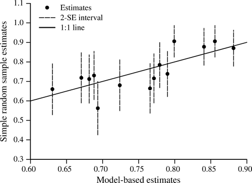
The primary advantages of model-based estimators are that they produce maps as by-products, estimates that are consistent with the maps in the sense that they represent the aggregation of mapping unit predictions, and possibly precise estimates for small areas for which only small numbers of sample observations are available. Their primary disadvantages are that they may be computationally intensive and they are not necessarily unbiased. Computational intensity results from the necessity of calculating variances and covariances for a large number of mapping units for even relatively small AOIs. For example, an AOI of radius 15 km includes centers for approximately 7.85×10⁵ 30×30 m Landsat pixels, meaning that the number of covariance estimates that must be calculated for eq. (Equation8) is of the order of 1010. However, eq. (Equation8) is just a two-dimensional mean over all units in the AOI and can be approximated by sampling from AOIs. Thus, McRoberts (Citation2010a) showed that the computational intensity may be greatly reduced with no discernible ill effects by using only pixels or mapping units located at the intersections of an equally spaced, two-dimensional, perpendicular grid superimposed on the AOI.
The issue of unbiasedness for model-based inference is closely linked to correct model specification. McRoberts (Citation2010a) reviews non-mathematical factors pertinent for forest mapping applications that may lead to deviations between observations and predictions and contribute to model lack of fit. Several approaches to assessing the correctness of model specification have been used. At the population unit level, if the model is correctly specified, a graph of observations versus model predictions should feature points that lie along a line with intercept 0 and slope 1. At the areal level, estimates, , may be compared to estimates,
, obtained using the SRS estimators with sample observations located in the AOI. Estimates,
, that are consistently within approximately two SRS standard errors of
indicate no serious lack of model fit and suggest unbiasedness of the estimator (McRoberts, Citation2010a) (). Finally, when the variance estimators are complex, non-parametric or based on unverified assumptions, bootstrap resampling approaches to variance estimation merit consideration (Efron & Tibshirani, Citation1994). However, two cautions are advised: first, the bootstrap resampling must capture the covariance structure of the original observations, and secondly, bootstrap bias estimates do not address model misspecification.
Figure 1. Assessing model misspecification for model-based inference: simple random sample estimates versus model-based estimates.
Examples of uses of model-based approaches to inference include McRoberts et al. (Citation2007), who used the kNN technique to infer small area means of proportion forest, basal area, volume and tree density. In addition, McRoberts (Citation2006McRoberts (Citation2010a)McRoberts (Citation2010b)) used logistic regression models to infer small area means of proportion forest, and Ståhl et al. (Citation2010) used a regression model with lidar data to infer population values of biomass.
Change detection
Detecting forest change
In remote sensing, the process of analyzing image data from two or more periods for the purpose of mapping cover change is commonly referred to as change detection. Multiple publications document remote sensing-based forest change detection methods, applications, limits and comparative results (Singh, Citation1989; Muchoney & Haack, Citation1994; Coppin et al., Citation2004). This section provides an update on how methods have changed over the past decade, and then looks to the future with a description of potential impacts of new approaches using both new and old data sets.
Sensor considerations
Forest composition and structure are shaped by both natural and anthropogenic forces, and understanding how forests change is crucial to predicting the character of future forests. Remote sensing methods for forest monitoring have been evolving since the Landsat program was established in the early 1970s. Since the early 1980s, detection and mapping of large-scale forest change have been possible using data from sensors such as AVHRR (Hansen & DeFries, Citation2004), MODIS (Langner et al., Citation2007) and VEGETATION (Fraser et al., Citation2003) (). However, the coarse spatial resolution of these sensors makes detected changes associated with forest management, which are commonly at a smaller grain, difficult to map accurately (Cohen et al., Citation2002; Hayes et al., Citation2008). Detailed, local mapping of forest change is possible with data from high spatial resolution airborne and spaceborne sensors such as IKONOS and QuickBird () (Clark et al., Citation2004), but these data are generally costly on a per unit area basis. Moreover, because these data have not been collected on a systematic, routine basis, they have limited use for widespread forest monitoring. Data from lidar sensors have great potential for forest monitoring because of their highly relevant quality (Kim et al., Citation2009), but repeated lidar coverage is only now becoming available (Næsset et al., Citation2004). Consequently, for most of the Earth's forests, lidar will remain a sampling and target-of-opportunity instrument for the foreseeable future owing to cost and the current lack of a suitable space-based platform. The Landsat program (), which has been collecting data routinely over most of the Earth's surface for nearly 40 years at a resolution commensurate with the spatial grain of forest management, has been the primary data source for monitoring forest change (Cohen & Goward, Citation2004; Masek et al., Citation2008; Huang et al., Citation2010). This situation is likely to continue, particularly because the data are now available at no cost if they reside in the archives of the US Geological Survey (Landsat Science Team, Citation2008), and because of the ongoing amalgamation of international archives and the planned continuation of the program. If long-term retrospective change detection is not important, then several other Landsat-class sensor choices merit consideration (Powell et al., Citation2007; Wulder et al., Citation2008b).
Past change detection approaches
Remote sensing-based approaches for detecting changes in vegetation can be categorized as two basic types: time series and interval. Time series approaches are based on regularly ordered images such as every 16 days for one or more years or once per year for numerous sequential years. The data for the time series are processed as a single data set to estimate trends and deviations in trends of spectral responses for the purpose of characterizing vegetation or vegetation change. Interval approaches are based on evaluations of transitions among vegetation classes for sequential pairs of multiple images acquired at either regular or irregular intervals.
Time series approaches have been largely the domain of high temporal, coarse spatial resolution sensors. For forest assessments, data from the AVHRR sensor were the first to be investigated. Largely focused on seasonality for one or more years at continental scales, these studies used principal components analysis (Johnson & Wichern, Citation1985) of temporal series to derive land cover classifications that distinguished forest from other vegetation cover types (Tucker et al., Citation1985), to examine interannual changes among forest and other land cover types (Lambin & Strahler, Citation1994), and to relate interannual changes in spectral responses of various vegetation types to climatic variations (Eastman & Fulk, Citation1993). Other studies focused on relating primary productivity in the form of vegetation growth as a function of latitude (Goward et al., Citation1987) or land use/cover type (Goward et al., Citation1985) to the sum over a growing season of spectral vegetation indices.
More recently, MODIS and VEGETATION data () have been used with interval approaches to map forest change directly. For one such study, forest harvest could not be detected for harvest patches of less than 20 ha; only when patch size was at least 50 ha could change be detected with high accuracy (Jin & Sader, Citation2005). Another study found that change due to fire could be accurately detected but only when burned areas were at least 10 km2 (Fraser et al., Citation2003). To minimize errors associated with classification of forest change using coarse-resolution data, other studies examined forest change in terms of proportions of image pixels that changed and found that both disturbance and recovery could be mapped with acceptable levels of error (Hayes & Cohen, Citation2007).
Interval approaches have largely been the domain of finer spatial resolution sensors such as Landsat, primarily because this class of sensors provides data that have both a lower temporal repeat cycle and, until recently, historically greater data cost. Early methods were based on postclassification comparisons (Singh, Citation1989; Coppin et al., Citation2004), whereby cover classifications from two separate images for a given location were compared (Hall et al., Citation1991). Other studies have been based on defining thresholds in two-date spectral space to classify change using a variety of statistical methods based on image subtraction, image division and principal components analysis, or by defining spectral change vectors having direction and magnitude (Muchoney & Haack, Citation1994; Cohen & Fiorella, Citation1998; Coppin et al., Citation2004). These methods have been extended to multiple two-date sets of imagery to classify forest changes associated with harvest (Cohen et al., Citation1998), fire (Eidenshink et al., Citation2007), insects (Goodwin et al., Citation2008) and forest recovery (Hayes & Sader, Citation2001). Recently, interval approaches have been extended to very broad areas, a strong indication of their continued utility.
Emerging developments in Landsat change detection
Time series approaches to forest change detection are not solely the domain of coarse-resolution sensors such as AVHRR and MODIS. However, whereas analyses based on the latter sensors rely primarily on the phenological signal contained in intra-annual time series, analyses based on Landsat time series (LTS) take advantage of annual or near-annual series for numerous years.
Lawrence and Ripple (Citation1999), who were among the first to use LTS for forest change detection, examined primary forest succession for 15 years after a volcanic eruption by characterizing differences in rates of cover accumulation. Schroeder et al. (Citation2007) used a 20-year annual LTS to characterize variation in secondary succession after harvest. Healey et al. (Citation2006) used LTS to map forest thinning for the purpose of understanding the deleterious effects of harvest on bird habitat. Kennedy et al. (Citation2007) were the first to develop a conceptual model for automated analyses of LTS for purposes of detecting forest change. Using high temporal density LTS increases the signal to noise ratio for forest change detection, thereby increasing the sensitivity of the data to subtle disturbance trends associated with chronic insect infestation, minor spectral departures associated with thinning and variations in recovery after disturbance.
The previously cited LTS studies were limited to a small number of Landsat scenes for two basic reasons: first, the analytical methods were nascent and in need of further development towards automation, and second, the high cost of data. Methods have now been developed to automate the analyses of time series over a large number of Landsat scenes (Huang et al., Citation2010Huang et al., ). In addition, Landsat data for much of the Earth's surface are now free and available in a standard, high-quality, preprocessed format (Landsat Science Team, Citation2008).
One particularly promising LTS approach was based on use of a limited set of expected spectral changes or deviations associated with a limited set of disturbance and regrowth combinations over the temporal series (Kennedy et al., Citation2007). This approach was based on comparing observations and expected sets of spectral trends to identify and label changes. Although this was a convenient way to initially frame the analysis, it had the effect of limiting resultant change maps to the predefined set of expectations. Because the observation period for the analysis was approximately 25 years, a large proportion of image pixels did not fit the expected set of conditions. Consequently, this approach is being altered by dropping the set of expectations in favor of identifying and defining temporal breaks in observed spectral trends and labeling the segments between two sequential break points as disturbance, recovery or stable, based on the direction or sign of spectral change.
Integrated change detection methods
In response to needs for detailed analyses for which Landsat-class resolution data may not be available at the temporal resolution desired because of image cloudiness or data gaps (Powell et al., Citation2007; Wulder et al., Citation2008b), new methods are being developed that blend data from multiple passive sensors. In addition, blending passive reflectance data from sensors having different temporal and spatial resolutions with data from active sensors such as lidar and radar that detect the strength and/or timing of reflectance of that energy will define the future of monitoring across a range of scales. A few examples highlight the potential for forest monitoring using fusion or blending methods.
One promising method for blending MODIS and Landsat data uses a variety of weighting functions derived from the co-occurrence of these data sets in time and space to predict Landsat images for dates where MODIS is available but Landsat is not (Gao et al., Citation2006). This algorithm, STARFM, is theoretically capable of predicting near-daily Landsat data from a single pair of MODIS and Landsat images and a daily time series of MODIS, although the results are improved if multiple Landsat anchor dates are used. Predicted Landsat images are degraded in quality for cases featuring fine-grained spatial heterogeneity and complex mixtures of cover types. Hilker et al. (Citation2009) demonstrated the value of STARFM for monitoring forest disturbance in Canada, where clouds often obscure Landsat images for several sequential 16-day acquisitions, by adapting the algorithm using 8-day MODIS composites to detect the 8-day period within which individual, Landsat-resolution disturbances occurred.
The Deformation, Ecosystem Structure, and Dynamics of Ice (DESDynI) space mission is to be launched later this decade (http://desdyni.jpl.nasa.gov/) with a primary goal of measuring and establishing monitoring protocols for vegetation structure and for understanding the carbon cycle. The DESDynI system will include both a mapping radar sensor and a sampling lidar sensor. The conceptual framework for blending disparate data sets from these two sensors for vegetation analysis is not new (Treuhaft et al., Citation2004), but at least some initial attempts at integrating lidar and radar data have demonstrated minimal advantage over lidar alone (Hyde et al., Citation2006; Nelson et al., Citation2007). However, the greatest value will be the extension of high-quality characterizations of forest structure from samples of lidar data to non-lidar-sampled areas through the spatially comprehensive radar data. Beneficial methods for integrating these data sets are likely to be developed, particularly for cloudy areas where radar has distinct advantages.
With the increasing number of sensors and data sets available, new paradigms are being developed for forest monitoring that take advantage of existing and advanced methods for specific sensor classes. The concept of multistage sampling in forestry is not new (Czaplewski, Citation1999), but successful integration of a variety of data sets for ongoing monitoring purposes has yet to be realized. Although DESDynI is one major step in that direction, many other sensor classes including MODIS, Landsat, QuickBird () and airphotos will ultimately be effectively integrated for monitoring forest change (GOFC-GOLD, Citation2009) in ways yet to be imagined.
Lidar
The use of data from lidar sensors, also known as laser altimetry, is growing rapidly, and lidar is about to become a major remote sensing technology for forestry applications. Lidar instruments are of many types and are operated from multiple platforms. This section provides a brief overview of technical aspects of lidar, illustrates the broad range of potential forest applications and emphasizes forest management inventories, with particular focus on the use of different types of instrumentation.
Lidar technology
Most lidar sensors emit a short duration pulse of light and measure the elapsed time between emission and detection of the reflected energy back at the sensor. The time is converted to distance or range by multiplying half the signal's travel time by the speed of light. Lidar instruments operated on the ground are known as terrestrial lidar, those carried on platforms such as fixed-wing aircraft and helicopters are known as airborne lidar, and those aboard satellites are known as spaceborne lidar. Although all types of platforms have been used in forest applications, this section focuses on airborne and spaceborne applications. When a lidar system is operated from aircraft, the sensor is usually integrated with systems that record the platform's three-dimensional (3D) position and orientation. Thus, highly precise ground positions on the order of 0.1 m or less can be provided for every laser measurement (Ahokas et al., Citation2003).
Laser pulses emitted from near nadir positions typically have circular or near circular outlines when they hit the ground. The diameter of the circle is known as the footprint diameter and typically varies from 0.1 to 20 m for airborne instruments and from 20 to 100 m for spaceborne instruments. Small-footprint systems with footprint diameters of 0.1–2.0 m are used primarily for commercial purposes such as operational mapping of topography and forest management inventories, whereas large-footprint systems with footprint diameters of 5–10 m are usually used for research purposes.
Lidar systems are further distinguished with respect to discrete return and full waveform. With discrete return lidar, a few distinct peaks of the continuous distribution of backscatter energy from the pulse reflection at the target on or near the ground are recorded as discrete echoes. Discrete return systems can usually store two to five distinct echoes per emitted pulse, the information necessary to produce 3D coordinates, and the echo intensity. In a forest, one or more echoes will often be reflected from vertical positions within and on the outer surface of the forest canopy, with the last echo reflected from the ground (). In forest gaps, only the single ground echo will be recorded. When aggregated over a target area such as a sample plot or forest stand, the collection of heights estimated from canopy echoes depicts the 3D structure of the forest and thus mimics the distribution of biological material in various vertical height layers. The first tasks with discrete return lidar data are usually to determine the terrain surface and then to estimate the height of each echo relative to the terrain. Discrete return systems are the most common with proprietary airborne lidars used for operational surveys.
Figure 2. Data recorded from an individual laser pulse emitted by small-footprint full-waveform lidar (the entire backscatter is recorded) and a discrete return lidar (discrete echoes are recorded; in this particular illustration a first echo, an intermediate echo and a last echo).
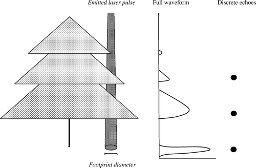
With full waveform lidar, the entire distribution of backscatter energy is recorded at discrete intervals for every emitted laser pulse. Thus, the waveform can consist of a vertical distribution of heights recorded at intervals such as 15 cm. Each individual waveform mimics the vertical distribution of biological material (). Large-footprint lidars are usually waveform systems and have been developed and used mainly for research purposes. However, the waveform principle is now also becoming available for small-footprint proprietary lidar systems. Full waveform systems generate much larger volumes of data than discrete return systems. Mallet and Bretar (Citation2009) provide a comprehensive review of full waveform lidar systems.
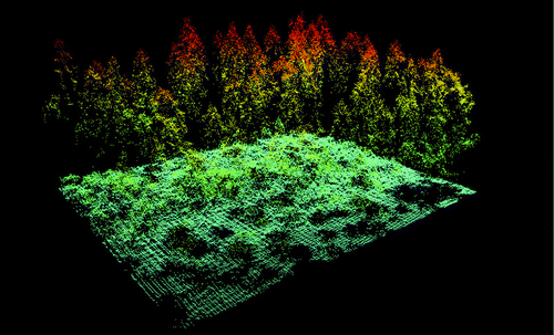
Emitted laser pulses are distributed using both profiling and scanning mechanisms. With profiling lidar, data are collected for consecutive footprints in a narrow strip beneath the platform. This mechanism was used by the first small-footprint lidars when they were introduced in forest research about 1980 and is still in use by small-footprint discrete return lidar research instruments and by large-footprint waveform lidars operated from aircraft or from space. The scanning mechanism is a feature of all proprietary lidars used for operational surveys. Multiple scanning mechanisms are used, but they all distribute the pulses continuously in wider swaths along the aircraft flight paths than the narrow strips characteristic of profiling systems. With small-footprint airborne lidars, also known as airborne laser scanning (ALS), swath widths range from 500 to 2000 m. Thus, scanning is an efficient means to collect data with full areal coverage. Small-footprint scanning lidar systems are used for topographic mapping and have to a large degree replaced photogrammetry in recent years. ALS is also used operationally in forest management inventories, as discussed below. An ALS data set with high density of measurements is shown in . Wehr and Lohr (Citation1999) provide further details regarding physical and technical aspects of airborne lidar and also describe various scanning mechanisms. Hyyppä et al. (Citation2008) provide an overview of small-footprint airborne lidar systems and their applications in forest research. Lim et al. (Citation2003) and Næsset et al. (Citation2004) report experiences with a broader suite of airborne lidar systems for forest applications.
Figure 3. Height measurements from an airborne laser scanning (ALS) data set of a spruce forest with high pulse density.
Lidar metrics as predictors of forest attributes
Airborne profiling lidar metrics.
Raw lidar data collected by small-footprint, discrete return, profiling lidar represent a two-dimensional height profile (Maclean & Krabill, Citation1986; Nelson at al., 1988) from which metrics such as cross-sectional areas and canopy heights have been shown to be related to forest attributes such as stand height, merchantable volume and biomass (Nelson et al., Citation1984, Citation1988). Over time, metrics derived from the profiles have been extended to include maximum height and mean of all or a selected number of the largest heights (Nelson et al., Citation1988), proportion of ground echoes to total number of emitted pulses, which is a measure of openness, and proportion of canopy hits to total number of emitted pulses, which is a measure of canopy cover. Quadratic mean height, calculated as the square root of the arithmetic mean of the individual squared lidar heights, gives greater weight to the higher measurements and has been commonly used. Based on their successful use in ALS studies, height percentiles such as the median have been proposed recently (Nelson et al., Citation2007). Height metrics have been used to represent different vertical canopy components by using varying lower threshold values such as 3 m.
Airborne scanning lidar metrics.
The first ALS studies commonly used metrics such as maximum and mean height values of canopy echoes and canopy cover density calculated as the proportion of canopy echoes to total number of emitted pulses for all pulses within a defined target area such as a sample plot or stand (Næsset, Citation1997a, Citation1997b). Since about 2000, ALS metrics have included means, medians, standard deviations, various percentiles of both tree and canopy heights, order statistics from the distribution of all echoes and proportions of the total numbers of echoes in vertical layers (Næsset, Citation2002).
A broad list of tree- and stand-level attributes may be estimated from ALS-derived metrics. Commonly estimated tree-level attributes include heights, cross-sectional crown areas and species (Hyyppä & Inkinen, Citation1999; Persson et al., Citation2002). Stand- or plot-level areal attributes include mean height, timber volume, canopy cover, tree size distributions (Næsset, Citation1997a, Citation1997b, Citation2002; Gobakken & Næsset, Citation2004, Citation2005) and species-specific proportions of stand attributes (Packalén & Maltamo, Citation2007; Hudak et al., Citation2008). In addition, recent studies have focused on attributes related to wood quality such as crown height, dead branch height and timber assortments (Næsset & Økland, Citation2002; Peuhkurinen et al., Citation2007; Maltamo et al., Citation2009).
Airborne and spaceborne full-waveform lidar metrics.
Because the entire distribution of backscatter energy is recorded for every emitted pulse with a full waveform lidar, the analysis of data acquired with such systems is usually conducted at a pulse level rather than as aggregates of echoes from multiple pulses along a segment as with a profiling discrete return lidar, or for areas as with ALS. For large-footprint systems, in particular, common metrics derived at the pulse level coincide to a large degree with those used for aggregates of echoes for discrete return systems. For example, maximum, median, mean and quadratic mean height have been used (Lefsky et al., Citation1999b), as well as the full range of percentiles (Drake et al., Citation2002). In addition, for data obtained from the spaceborne Geoscience Laser Altimeter System (GLAS), metrics related to the length of the waveform, which is the distance from the start to the end of the signal or from the start of the signal to the last peak of the signal, have been used as measures of vegetation height. Multiple other metrics, some rather complex, have been proposed, including those noted by Nelson et al. (Citation2009) for estimating timber volume.
Relating forest attributes and lidar metrics.
Regression modeling techniques are most frequently used to describe relationships between forest attributes and lidar metrics for data obtained from profiling and ALS systems. However, non-parametric methods such as the kNN technique have also been used with good results (Maltamo et al., Citation2006b, Citation2009; Packalén & Maltamo, Citation2007; Hudak et al., Citation2008). For full waveform data, regression approaches have also been commonly used. When the footprint diameters for the latter data are on the order of 10 m, regression analyses have even been conducted at footprint level using field measurements for every footprint (Lefsky et al., Citation1999b). provides a summary of forest attributes predicted using lidar metrics; the emphasis is on providing examples from different continents and with different instrumentation.
Table III. Relationships between forest structural attributes and lidar metrics.
Lidar applications for forest structure, composition and ecology
Lidar data's unique capability to depict the 3D structure of the ground surface, trees, canopies and other vegetation attributes with fine spatial resolution over large geographical areas has attracted the attention of researchers in many forest resource and ecological disciplines. A few examples suffice to illustrate the diversity of applications.
Forest structure and composition.
For forest ecology applications, estimates of structural parameters obtained from lidar data have been used to model the probability of vegetation types in boreal forests (Vehmas et al., Citation2009), to map woodland understories (Hill & Broughton, Citation2009) and to quantify forest floristics (Tickle et al., Citation2006). Hill and Thomson (Citation2005) reported strong relationships between tree and shrub species composition and structure as forest attributes and structural metrics obtained from lidar data. Strong correlations have been found between indicators of the success of natural regeneration and structural lidar metrics in unmanaged forests (Bollandsås et al., Citation2008). Because lidar data with high pulse density can detect trees shorter than even 1 m, they have been suggested to be useful for monitoring tree migration in the alpine and arctic tree lines in response to climate change and changing land use (Næsset & Nelson, Citation2007). Korpela (Citation2008) found that lidar intensity values discriminated well between lichens and other ground vegetation. Precise lidar-based estimation of leaf area index (LAI) from small-footprint data (Morsdorf et al., Citation2006) contributed to the detection of defoliation of Scots pine in Norway due to a severe insect attack (Solberg et al., Citation2006).
Lidar data can be used to predict the species of individual trees, at least in boreal forests with relatively few tree species. Such predictions can be improved using a fusion of lidar data and aerial imagery (Holmgren et al., Citation2008). However, dense lidar data have been shown to produce accurate tree-level species classification, even without supporting aerial imagery (Vauhkonen et al., Citation2009). Hyyppä et al. (Citation2008) provide a review of studies dealing with tree species classification.
Habitat.
Lidar data have been shown to be particularly important for forest habitat studies. Nelson et al. (Citation2005) used structural lidar metrics to model habitat suitability for small mammals such as squirrels. Müller and Brandl (Citation2009) demonstrated that the richness and composition of assemblages of forest-dwelling beetles are strongly correlated with structural lidar metrics. In their pioneering study on habitat quality for great tits and blue tits in the United Kingdom, Hinsley et al. (Citation2002) reported a significant relationship between mean chick mass and vegetation height derived from lidar data. In an analysis of the suitability of a forest reserve in the Alps as habitat for capercaillie, Graf et al. (Citation2009) reported good relationships between presence–absence patterns and lidar-derived metrics of horizontal and vertical canopy structure. Bradbury et al. (Citation2005) provide a brief review of other studies linking bird characteristics to estimates of forest structure obtained from lidar data.
Wildfire.
For purposes of modeling wildfire behavior, relevant canopy structural features such as tree height, tree cover, surface canopy height, surface canopy cover, crown bulk density, crown volume and foliage biomass have all been shown to be strongly correlated with metrics derived from lidar data (Riaño et al., Citation2003; Morsdorf et al., Citation2004). Sensitivity analyses of fire behavior models have shown that lidar data can improve the accuracy of fuel mapping and can provide more detailed information about fire characteristics (Mutlu et al., Citation2008). Erdody and Moskal (Citation2010) provide a short review of studies investigating relationships between lidar data and the canopy properties typically used in wildfire modeling.
Lidar applications for forest management inventories
Forest inventory is one of the most investigated and potentially most useful applications for lidar data. For this discussion, the focus is on management inventories; McRoberts et al. (Citation2010) address applications for national forest inventories.
Airborne scanning lidar.
The first operational and commercial ALS-supported management inventory was conducted in Norway in 2002 (Næsset, Citation2004b), and such inventories have since become standard practice in the Nordic countries. Laser pulse densities of 0.5–1.0 pulses m−2 are typically used for area-based inventories and provide stable and accurate results, at least in conifer forests (Maltamo et al., Citation2006a; Gobakken & Næsset, Citation2009; Magnussen et al., Citation2010). Wulder et al. (Citation2008a) assert that lidar now has moved from research and development to operational implementation over a broad range of forest inventory attributes. Tests are also being conducted to incorporate ALS as an operational tool to facilitate forest management and inventories in other parts of the world: Australia (Rombouts et al., Citation2010), Austria (Hollaus et al., Citation2007), Canada (Thomas et al., Citation2006), Germany (Breidenbach et al., Citation2008) and the United States of America (Jensen et al., Citation2006).
With the introduction of small-footprint, proprietary ALS systems for forest research in about 1995 (Næsset, Citation1997a, Citationb), lidar-based height information became available as 3D, wall-to-wall data. The first studies pointed toward great opportunities for accurate estimation of stand-level inventory attributes such as mean tree height and timber volume (Næsset, Citation1997a, Citationb; Magnussen & Boudewyn, Citation1998; Means et al., Citation2000). Although ALS data were shown to underestimate tree heights (Næsset, Citation1997a; Magnussen & Boudewyn, Citation1998), adjustments using field data could be used to correct the estimates. Næsset (Citation1997a), p. 55, 1997b, p. 252) proposed an approach featuring construction of models of stand properties using data from georeferenced field sample plots and corresponding ALS metrics distributed over AOIs as large as 100–500 km2. The models would then be used to predict properties for individual stands within the larger areas. For this type of application, the models are considered synthetic in the sense that they are based on data external to the AOI to which they are applied (Särndal et al., Citation1992). Means et al. (Citation2000) asserted that ALS offers great potential for savings compared to conventional management inventories, and Eid et al. (Citation2004) confirmed that ALS can be more cost-efficient for management inventories than the extensive use of aerial photography combined with field checking.
For stand-level estimation, approaches using models and model predictions typically have four components: (1) construction of models of the relationships between ground plot observations of forest attributes and ALS-derived metrics; (2) division of stands into grid cells equal in size to the ground plots; (3) prediction of forest attributes of interest for every cell; and (4) aggregation of the individual cell predictions to obtain stand-level estimates. Although the primary purpose is to estimate stand-level attributes, the cell predictions actually constitute a forest attribute map. Næsset and Bjerknes (Citation2001) and Næsset (Citation2002) provided proofs of concept for this approach; the concept was later validated for forest stands of 0.02–5.00 ha using both small control studies and full-scale operational tests in multiple countries. Næsset (Citation2002, Citation2004a, Citation2004b, Citation2007), Holmgren (Citation2004) and Maltamo et al. (Citation2006a) all reported that ALS-based management inventories can produce estimates of stand attributes such as mean tree height, dominant height, mean stem diameter, stem number, stand basal area and stand volume under boreal forest conditions that are more accurate than estimates obtained from conventional management inventories based on fieldwork and aerial photography. Næsset's (Citation2007) review of Nordic studies indicates that varying levels of precision, expressed as percentages of means, may be expected: mean height, 3.0–6.4%; dominant height, 3.4–8.0%; mean diameter, 5.9–15.5%; stem number, 11.6–29.3%; stand basal area, 8.6–14.4%; and stand volume, 7.9–14.3%. Of particular recent interest, Asner (Citation2009) proposed monitoring above-ground biomass and carbon in tropical countries under the UN-REDD (Reducing Emissions from Deforestation and Forest Degradation) program (http://www.un-redd.org/) using areal estimation methods with wall-to-wall ALS coverage. Whenever the lidar data are available as canopy surface models only and not as raw data consisting of echoes from the individual laser pulses, only the lidar height information may be used for inventory purposes, i.e. information on canopy density must be ignored. For such a special case Corona and Fattorini (Citation2008) reported an interesting probability-based sampling approach.
Estimators using synthetic regression models for small domains such as individual forest stands for which no field data are available have been shown to be very precise, albeit with possibly large biases (Särndal et al., Citation1992, pp. 410–411). Estimation does not provide any means for controlling potential bias and depends entirely on correctly specified models. Næsset (Citation2007) reported that for Nordic conditions application of synthetic models to local AOIs with no use of local data to adjust estimates, stand-level bias is moderate, generally less than 10% and in most cases less than 5%. In a simulation study, Andersen and Breidenbach (Citation2007) compared estimators using synthetic models with no local adjustment to modified estimators with local adjustments and reported that local stand-specific plot data can be used to adjust estimates to reduce the effects of local model misspecification. However, collection of stand-level field data is not feasible for local bias control in large area operational forest management inventories.
Airborne profiling lidar.
The very first investigations of small-footprint discrete return lidar in forest research used profiling systems (Solodukhin et al., Citation1977; Nelson et al., Citation1984). Because profiling systems only collect data along a narrow strip beneath the platform, profiling lidar data must be considered along separate flight lines. Thus, in forest inventory, the use of profiling lidar has been limited to sample survey and has not found any applications in management inventories.
The first forest sample survey with airborne profiling lidar was conducted in Delaware, USA (Nelson et al., Citation2003b, Citation2004), where data were collected with the Portable Airborne Laser System (PALS) (Nelson et al., Citation2003a) profiling lidar system for 56 flight lines spaced 1 km apart. Models of the relationships between merchantable volume and biomass estimated from ground samples and crown closure and height metrics derived from the lidar profiles obtained separately were used to predict biomass and volume along all the flight lines. Statewide volume and biomass estimates based on data for only every fourth flight line were within 1–16% of the estimates reported by the Forest Inventory and Analysis program of the US Forest Service (Nelson et al., Citation2004). A forest inventory using the PALS lidar and a similar design was later conducted in Ehime Prefecture, Japan (Tsuzuki et al., Citation2008).
In 2006, Hedmark County, Norway (~27,000 km2), was sampled with the PALS profiling lidar using 105 parallel flight lines spaced 3 km apart that coincided with the 3 × 3 km grid of 250 m2 permanent sample plots of the Norwegian National Forest Inventory. Regression models of the plot-based estimates of biomass versus lidar-derived height and canopy density metrics were constructed for use with two sample-based estimators, one assuming a probability-based framework (Gregoire et al., Citationin press) and the other a model-based framework (Ståhl et al., Citationin press). The county was also sampled with an ALS instrument flown along 53 flight lines spaced 6 km apart. Similar sample-based estimators were developed as for the profiling application.
Spaceborne lidar.
The GLAS onboard the ICESat satellite has been the only spaceborne lidar sensor with the capacity to assess vegetation structure. The GLAS instrument is a full waveform, profiling lidar with nominal ground footprint diameter of approximately 65 m (Schutz et al., Citation2005). For an inventory in Quebec, Canada, Boudreau et al. (Citation2008) used a two-phase, model-based design to estimate above-ground forest biomass. GLAS footprints systematically distributed over the entire AOI were used as the first phase sample, and PALS airborne profiling lidar data for a subset of the GLAS footprints constituted the second phase sample. A model based on the relationship between plot biomass for a purposive sample of ground plots and corresponding PALS lidar metrics was used to predict biomass for the GLAS footprints, and a second model of the relationship between the predicted biomass and the GLAS lidar metrics was used to predict biomass for all the GLAS footprints. Among the important results, 36% of the above-ground biomass was found to be north of what is considered to be Quebec's commercial forest. For a study in central Siberia, Nelson et al. (Citation2009) used a model of the relationship between timber volume obtained from field plots corresponding to a purposive sample of GLAS footprints and GLAS lidar metrics to predict volume for all footprints. The estimate of total timber volume corresponded well with an estimate from a previous independent inventory.
However, both GLAS studies identified difficulties. For the Quebec study, the large GLAS footprint caused the laser pulses to strike lower elevation canopy tops at the same time as higher elevation ground in areas with moderate to high relief and produced a waveform that was complex and difficult to interpret (Harding & Carajabal, Citation2005). For the Siberian study, volume tended to be overestimated for terrain with slopes greater than 10 degrees because of confounding of higher altitude topography with the forest canopy. Future large area inventories using data from spaceborne lidar systems may profit from smaller footprints such as the ~ 25 m footprint of NASA's planned DESDynI mission (http://desdyni.jpl.nasa.gov/).
Additional considerations
Accurate co-registration of field plots and ALS footprints is crucial to exploit the full potential of lidar data (Gobakken & Næsset, Citation2009). Current, state-of-the-art global positioning systems may be expected to produce location accuracies in the 0.1–1.0 m range for field plots in boreal forests.
When planning ALS acquisition for forest inventories, the properties of ALS data obtained with different sensors must be considered. For example, factors such as flying altitude, pulse repetition frequency and footprint size on the data may affect estimates of forest attributes (Næsset & Gobakken, Citation2008; Næsset, Citation2009). When the instrument and acquisition parameters are kept constant between inventories, models developed for one AOI can be applied to adjacent AOIs and hence reduce the necessary fieldwork and reduce costs (Næsset et al., Citation2005; Næsset, Citation2007). However, when sensors or acquisition parameters differ between AOIs, models should be constructed using locally acquired data to reduce the risk of bias in the estimators as a result of model misspecification (Næsset, Citation2009). Wulder et al. (Citation2008a) identifies factors that should be considered when planning acquisition of ALS data for forest inventories with specific focus on Canadian conditions.
Summary and conclusions
The relatively recent, but nevertheless widespread, availability of remotely sensed data has been a boon to forest researchers, particularly those interested in spatial analyses. Techniques for predicting forest attributes from remotely sensed data as a means of constructing maps have often simply been borrowed from other disciplines. Therefore, it is not surprising that the general topic area of parametric approaches to classification for categorical response variables and prediction for continuous response variables is one of the more mature aspects of remote sensing-based applications. Non-parametric approaches to classification and prediction, however, continue to attract attention, at least partially because forest attribute and remotely sensed data often cannot be characterized using familiar statistical distributions. Similarly, accuracy assessment may also be considered a relatively mature topic area, although selection of accuracy assessment sampling designs that are cost-efficient and produce acceptably precise estimates of accuracy measures still merits considerable attention.
The status of approaches to inference using remotely sensed data reflects both perplexity and mixed levels of maturity. The perplexity arises from the relative lack of reported attempts to construct inferences for maps or using map data, even though probability-based approaches to inference are both relatively familiar and easy. Thus, despite their relative lack of use, probability-based approaches to inference may be regarded as relatively mature. Such is not the case for model-based approaches to inference, which are less familiar, much less commonly reported, more complex, subject to a greater degree of computational intensity and require bias assessments. Nevertheless, the utility of model-based inference, particularly for small area estimation and map applications, justifies continued exposition and research.
As classification and prediction techniques matured and as acquisition of remotely sensed data was replicated for annual and near-annual time steps, the extension to change detection was natural. Whereas the first approaches to change detection were based on comparisons of separately classified images, later more powerful approaches were developed that combined data for multiple time steps into a single data set. Change detection may properly be characterized as an emerging topic area on the basis of a lack of accepted standardizations, although the expected demands for change detection products will surely promote rapid increases in maturity.
Nearly anything related to lidar is currently a topic of interest for the forest research community. To an even greater degree than change detection, lidar applications must be considered immature because of the variety of kinds of lidar data, the lack of consensus on prediction methods, the lack of very large area applications, the lack of accepted methods for accommodating the quantity of data and the costs. Nevertheless, progress made on incorporating lidar data into operational forest management inventories suggests that increased maturity will be forthcoming shortly.
Five conclusions may be drawn from this review. First, and most importantly, remotely sensed data have greatly contributed far beyond field data alone to two important functions: adding a spatial component to forest attribute information via the construction of maps and reducing the costs of forest inventories. Secondly, continued attention to non-parametric, multivariate approaches to forest attribute classification and prediction using remotely sensed data is warranted. Thirdly, greater attention should be paid to map-based inference, particularly when it can be approached as a relatively easy extension of accuracy assessments. As a necessary component, methods for estimating the variances of mapping unit estimates must become familiar and must be incorporated into standard software packages. For model-based inference, three areas merit consideration: (1) educating researchers and practitioners on the utility of model-based inference; (2) developing consensus on methods for easily assessing model misspecification as it pertains to bias; and (3) investigation of methods for reducing the computational intensity. Fourthly, despite the current relative immaturity of change detection methods, their relevance and utility for assessing the effects of climate change on forests and for assessing deforestation and forest degradation under the auspices of the UN-REDD program cannot be underestimated. Broad, generalized comparisons of approaches to change detection and development of supporting inferential methods merit attention. Fifthly, the intense interest in lidar-based research will without doubt lead to exciting developments and greater consensus. The development of inferential methods for use with lidar data indicates progress toward maturity.
Additional information
Notes on contributors
Erkki O. Tomppo
No relevance should be attributed to the order of the authors; all authors contributed equallyRelated Research Data
References
- Ahern , F. J. , Erdle , T. , MacLean , D. A. and Kneppeck , I. D. 1991 . A quantitative relationship between forest growth rates and Thematic Mapper reflectance measurements . International Journal of Remote Sensing , 12 : 387 – 400 .
- Ahokas , E. , Kaartinen , H. and Hyyppä , J. 2003 . A quality assessment of airborne laser scanner data. International Archives of Photogrammetry . Remote Sensing and Spatial Information Sciences , 34 ( Part 3/W13 ) : 1 – 7 .
- Andersen , H.-E. & Breidenbach , J. 2007 . Statistical properties of mean stand biomass estimators in a LIDAR-bases double sampling forest survey design . Proceedings of the ISPRS Workshop Laser Scanning 2007 and SilviLaser 2007 , Espoo, Finland, September 12–14, 2007. IAPRS , XXXVI Part 3/W52 , pp. 8 13 .
- Asner , G. 2009 . Tropical forest carbon assessment: Integrating satellite and airborne mapping approaches . Environmental Research Letters , 4 : 034009
- Baffetta , F. , Fattorini , L. , Franceschi , S. and Corona , P. 2009 . Design-based approach to k-nearest neighbours technique for coupling field and remotely sensed data in forest surveys . Remote Sensing of Environment , 11 : 463 – 475 .
- Biging , G. S. , Colby , D. R. and Congalton , R. G. 1998 . “ Sampling systems for change detection accuracy assessment ” . In Remote sensing change detection: Environmental monitoring methods and applications , Edited by: Lunetta , R. S. and Elvidge , C. D. 281 – 308 . Chelsea, MI : Ann Arbor Press .
- Binaghi , E. , Brivio , P. A. , Ghezzi , P. and Rampini , A. 1999 . A fuzzy set-based accuracy assessment of soft classification . Pattern Recognition Letters , 20 : 935 – 948 .
- Blackard , J. A. , Finco , M. V. , Helmer , E. H. , Holden , G. R. , Hoppus , M. L. Jacobs , D. M. 2008 . Mapping US forest biomass using nationwide forest inventory data and moderate resolution information . Remote Sensing of Environment , 112 : 1658 – 1677 .
- Bollandsås , O. M. , Holt Hanssen , K. , Marthiniussen , S. and Næsset , E. 2008 . Measures of spatial forest structure derived from airborne laser data are associated with natural regeneration patterns in an uneven-aged spruce forest . Forest Ecology and Management , 255 : 953 – 961 .
- Boudreau , J. , Nelson , R. F. , Margolis , H. A. , Beaudoin , A. , Guindon , L. and Kimes , D. 2008 . Regional aboveground forest biomass using airborne and spaceborne LiDAR in Quebec . Remote Sensing of Environment , 112 : 3876 – 3890 .
- Bradbury , R. B. , Hill , R. A. , Mason , D. C. , Hinsley , S. A. , Wilson , J. D. Baltzer , H. 2005 . Modelling relationships between birds and vegetation structure using airborne LiDAR data: A review with case studies from agricultural and woodland environments . Ibis , 147 : 443 – 452 .
- Breidenbach , J. , Koch , B. , Kändler , G. and Kleusberg , A. 2008 . Quantifying the influence of slope, aspect, crown shape and stem density on the estimation of tree height at plot level using Lidar and InSAR data . International Journal of Remote Sensing , 29 : 1511 – 1536 .
- Breiman , L. 2001 . Random forests . Machine Learning , 45 : 5 – 32 .
- Breiman , L. & Cutler , A. 2010 . Random forests . Retrieved fromhttp://www.stat.berkeley.edu/~breiman/RandomForests/cc_software.htm [Accessed 6 July 2010]
- Brewer , K. R. W. 1963 . Ratio estimation in finite populations: Some results deductible from the assumption of an underlying stochastic process . Australian Journal of Statistics , 5 : 93 – 105 .
- Chambers , R. 2003 . An introduction to model-based survey sampling . Retrieved November 2009, from http://www.eustat.es/prodserv/seminario_i.html
- Clark , D. B. , Castro , C. S. , Alvarado , L. D. A. and Read , J. M. 2004 . Quantifying mortality of tropical rain forest trees using high-spatial-resolution satellite data . Ecology Letters , 7 : 52 – 59 .
- Cochran , W. G. 1977 . Sampling techniques , 3rd ed , New York : Wiley .
- Cohen , J. 1960 . A coefficient of agreement for nominal scales . Educational and Psychological Measurement , 20 : 37 – 46 .
- Cohen , W. B. and Fiorella , M. 1998 . “ Comparison of methods for detecting conifer forest change with Thematic Mapper imagery ” . In Remote sensing change detection: Environmental monitoring methods and applications , Edited by: Lunetta , R. S. and Elvidge , C. D. 89 – 102 . Chelsea, MI : Ann Arbor Press .
- Cohen , W. B. , Fiorella , M. , Gray , J. , Helmer , E. and Anderson , K. 1998 . An efficient and accurate method for mapping forest clearcuts in the Pacific Northwest using Landsat imagery . Photogrammetric Engineering and Remote Sensing , 64 : 293 – 300 .
- Cohen , W. B. and Goward , S. N. 2004 . Landsat's role in ecological applications of remote sensing . BioScience , 54 : 535 – 545 .
- Cohen , W. B. , Spies , T. A. , Alig , R. J. , Oetter , D. R. , Maiersperger , T. K. and Fiorella , M. 2002 . Characterizing 23 years (1972–1995) of stand replacement disturbance in western Oregon forests with Landsat imagery . Ecosystems , 5 : 122 – 137 .
- Cohen , W. B. , Spies , T. A. and Fiorella , M. 1995 . Estimating the age and structure of forests in a multi-ownership landscape of western Oregon, USA . International Journal of Remote Sensing , 16 : 721 – 746 .
- Congalton , R. G. and Green , K. 1999 . Assessing the accuracy of remotely sensed data: Principles and practices , Boca Raton, FL : CRC Press .
- Coops , N. C. , Hilker , T. , Wulder , M. A. , St-Onge , B. , Newnham , G. , Siggis , A. and Trofymow , J. A. 2007 . Estimating canopy structure of Douglas-fir forest stands from discrete-return liDAR . Trees , 21 : 295 – 310 .
- Coppin , P. , Jonckheere , I. , Nackaerts , K. , Muys , B. and Lambin , E. 2004 . Digital change detection methods in ecosystem monitoring: A review . International Journal of Remote Sensing , 25 : 1565 – 1596 .
- Corona , P. and Fattorini , L. 2008 . Area-based lidar-assisted estimation of forest standing volume . Canadian Journal of Forest Research , 38 : 2911 – 2916 .
- Crist , E. P. and Cicone , R. C. 1984 . Application of the tasseled cap concept to simulated Thematic Mapper data . Photogrammetric Engineering and Remote Sensing , 50 : 343 – 352 .
- Czaplewski , R. 1999 . Towards an annual national inventory . Journal of Forestry , 12 : 44 – 48 .
- Czaplewski , R. L. 2003 . “ Accuracy assessment of maps of forest condition: Statistical design and methodological considerations ” . In Remote sensing of forest environments: Concepts and case studies , Edited by: Wulder , M. A. and Franklin , S. E. 115 – 140 . Boston, MA : Kluwer .
- Czaplewski , R. L. and Catts , G. P. 1992 . Calibration of remotely sensed proportion or area estimates for misclassification error . Remote Sensing of Environment , 39 : 29 – 43 .
- Danson , F. M. and Curran , P. J. 1993 . Factors affecting the remotely sensed response of coniferous forest plantations . Remote Sensing of Environment , 43 : 55 – 65 .
- Dawid , A. P. 1983 . “ Statistical inference I ” . In Encyclopedia of statistical sciences , Edited by: Kotz , S. and Johnson , N. L. Vol. 4 , 89 – 105 . New York : Wiley .
- De Mast , J. 2007 . Agreement and kappa-type indices . The American Statistician , 61 : 148 – 153 .
- Dong , J. , Kaufmann , R. K. , Myneni , R. B. , Tucker , C. J. , Kauppi , P. E. Liski , J. 2003 . Remote sensing estimates of boreal and temperate forest woody biomass: Carbon pools, sources, and sinks . Remote Sensing of Environment , 84 : 393 – 410 .
- Drake , J. B. , Dubayah , R. O. , Knox , R. G. , Clark , D. B. and Blair , J. G. 2002 . Sensitivity of large-footprint lidar to canopy structure and biomass in a neotropical rainforest . Remote Sensing of Environment , 81 : 378 – 392 .
- Drake , J. B. , Knox , R. G. , Dubayah , R. O. , Clark , D. B. , Condit , R. , Blair , J. B. and Hofton , M. 2003 . Above-ground biomass estimation in closed canopy Neotropical forests using lidar remote sensing: Factors affecting the generality of relationships . Global Ecology and Biogeography , 12 : 147 – 159 .
- Duncanson , L. I. , Niemann , K. O. and Wulder , M. A. 2009 . Estimating forest canopy height and terrain relief from GLAS waveform metrics . Remote Sensing of Environment , 114 : 138 – 154 .
- Eastman , J. R. and Fulk , M. 1993 . Long sequence time series evaluation using standardized principal components . Photogrammetric Engineering and Remote Sensing , 59 : 1307 – 1312 .
- Efron , B. and Tibshirani , R. J. 1994 . An introduction to the bootstrap , New York : Chapman & Hall .
- Eid , T. , Gobakken , T. and Næsset , E. 2004 . Comparing stand inventories based on photo interpretation and laser scanning by means of cost-plus-loss analyses . Scandinavian Journal of Forest Research , 19 : 512 – 523 .
- Eidenshink , J. , Schwind , B. , Brewer , K. , Zhu , Z.-L. , Quayle , B. and Howard , S. 2007 . A project for monitoring trends in burn severity . Fire Ecology , 3 : 3 – 21 .
- Eklundh , L. , Johansson , T. and Solberg , S. 2009 . Mapping insect defoliation in Scots pine with MODIS time-series data . Remote Sensing of Environment , 113 : 1566 – 1573 .
- Erdody , T. L. and Moskal , L. M. 2010 . Fusion of LiDAR and imagery for estimating forest canopy fuels . Remote Sensing of Environment , 114 : 725 – 737 .
- Foody , G. M. 2002 . Status of land cover classification accuracy assessment . Remote Sensing of Environment , 80 : 185 – 201 .
- Foody , G. M. 2004 . Thematic map comparison: Evaluating the statistical significance of differences in classification accuracy . Photogrammetric Engineering and Remote Sensing , 70 : 627 – 633 .
- Foody , G. M. , Boyd , D. S. and Cutler , M. E. J. 2003 . Predictive relations of tropical forest biomass from Landsat TM data and their transferability between regions . Remote Sensing of Environment , 85 : 463 – 474 .
- Foody , G. M. , Cutler , M. E. , McMorrow , J. , Pelz , D. Tangki , H. 2001 . Mapping the biomass of Bornean tropical rain forest from remotely sensed data . Global Ecology and Biogeography , 10 : 379 – 387 .
- Franklin , J. , Beardsley , D. , Gordon , H. , Simons , D. K. and Rogan , J. M. 2001 . Evaluating errors in a digital vegetation map with forest inventory data and accuracy assessment using fuzzy sets . Transactions in GIS , 5 : 285 – 304 .
- Fraser , R. H. , Fernandes , R. and Latifovic , R. 2003 . Multi-temporal mapping of burned forest over Canada using satellite-based change metrics . Geocarto International , 18 : 37 – 47 .
- Gao , F. , Masek , J. , Schwaller , M. and Hall , F. 2006 . On the blending of the Landsat and MODIS surface reflectance: Predicting daily Landsat surface reflectance . IEEE Transactions on Geoscience and Remote Sensing , 44 : 2207 – 2218 .
- Gemmell , F. M. 1995 . Effects of forest cover, terrain, and scale on timber volume estimation with Thematic Mapper data in a Rocky Mountain site . Remote Sensing of Environment , 51 : 291 – 305 .
- Gobakken , T. and Næsset , E. 2004 . Estimation of diameter and basal area distributions in coniferous forest by means of airborne laser scanner data . Scandinavian Journal of Forest Research , 19 : 529 – 542 .
- Gobakken , T. and Næsset , E. 2005 . Weibull and percentile models for lidar-based estimation of basal area distribution . Scandinavian Journal of Forest Research , 20 : 490 – 502 .
- Gobakken , T. and Næsset , E. 2009 . Assessing effects of positioning errors and sample plot size in biophysical stand properties derived from airborne laser scanner data . Canadian Journal of Forest Research , 39 : 1036 – 1052 .
- GOFC-GOLD 2009 . A sourcebook of methods and procedures for monitoring measuring and reporting anthropogenic greenhouse gas emissions and removals caused by deforestation, gains and losses of carbon stocks in forests remaining forests, and forestation GOFC-GOLD Report Version COP15-1 . Alberta : GOFC-GOLD Project Office, Natural Resources Canada .
- Goodwin , N. R. , Coops , N. C. , Wulder , M. A. , Gillanders , S. , Schroeder , T. A. and Nelson , T. 2008 . Estimation of insect infestation dynamics using a temporal sequence of Landsat data . Remote Sensing of Environment , 112 : 3680 – 3689 .
- Gopal , S. and Woodcock , C. 1994 . Theory and methods for accuracy assessment of thematic maps using fuzzy sets . Photogrammetric Engineering and Remote Sensing , 60 : 181 – 188 .
- Goward , S. N. , Dye , D. , Kerber , A. and Kalb , V. 1987 . Comparison of North and South American biomes from AVHRR observations . Geocarto International , 2 : 27 – 39 .
- Goward , S. N. , Tucker , C. J. and Dye , D. G. 1985 . North American vegetation patterns observed with the NOAA-7 Advanced Very High Resolution Radiometer . Vegetatio , 64 : 3 – 14 .
- Graf , R. F. , Mathys , L. and Bollmann , K. 2009 . Habitat assessment for forest dwelling species using LiDAR remote sensing: Capercaillie in the Alps . Forest Ecology and Management , 257 : 160 – 167 .
- Graubard , B. I. and Korn , E. L. 2002 . Inference for superpopulation parameters using sample surveys . Statistical Science , 17 : 73 – 96 .
- Gregoire , T. 1998 . Design-based and model-based inference: Appreciating the difference . Canadian Journal of Forest Research , 28 : 1429 – 1447 .
- Gregoire , T. G. , Ståhl , G. , Næsset , E. , Gobakken , T. , Nelson , R. & Holm , S. 2010 . Model-assisted estimation of biomass in a LiDAR sample survey in Hedmark county, Norway . Canadian Journal of Forest Research in press .
- Hagen , A. 2003 . Fuzzy set approach to assessing similarity of categorical maps . International Journal of Geographical Information Science , 17 : 235 – 249 .
- Hall , F. G. , Botkin , D. B. , Strebel , D. E. , Woods , K. D. and Goetz , S. J. 1991 . Large-scale patterns in forest succession as determined by remote sensing . Ecology , 72 : 628 – 640 .
- Häme , T. , Stenberg , P. , Andersson , K. , Rauste , Y. , Kennedy , P. , Folving , S. and Sarkeala , J. 2001 . AVHRR-based forest proportion map of the pan-European area . Remote Sensing of Environment , 77 : 76 – 91 .
- Hansen , M. C. and DeFries , R. S. 2004 . Detecting long-term global forest change using continuous fields of tree-cover maps from 8-km Advanced Very High Resolution Radiometer (AVHRR) data for the years 1982–99 . Ecosystems , 7 : 695 – 716 .
- Hansen , M. C. , DeFries , R. S. , Townshend , J. R. G. , Carroll , M. , Dimiceli , C. and Sohlberg , R. A. 2003 . Global percent tree cover at a spatial resolution of 500 meters: First results of the MODIS Vegetation Continuous Fields algorithm . Earth Interactions , 7 : 1 – 15 .
- Hansen , M. H. , Madow , W. G. and Tepping , B. J. 1983 . An evaluation of model-depending and probability-sampling inferences in sample surveys . Journal of the American Statistical Association , 78 : 776 – 793 .
- Haralick , R. , Shanmugam , K. and Dinstein , I. 1973 . Textural features for image classification. IEEE Transactions on Systems . Man and Cybernetics , 3 : 610 – 622 .
- Harding , D. J. and Carajabal , C. C. 2005 . ICESat waveform measurements of within-footprint topographic relief and vegetation vertical structure . Geophysical Research Letters , 32 : L21S10
- Hayes , D. J.& and Cohen , W. B. 2007 . Spatial, spectral and temporal patterns of tropical forest cover change as observed with multiple scales of optical satellite data . Remote Sensing of Environment , 106 : 1 – 16 .
- Hayes , D. J. , Cohen , W. B. , Sader , S. A. and Irwin , D. E. 2008 . Estimating proportional change in forest cover as a continuous variable from multi-year MODIS data . Remote Sensing of Environment , 112 : 735 – 749 .
- Hayes , D. J. and Sader , S. A. 2001 . Change detection techniques for monitoring forest clearing and regrowth in a tropical moist forest . Photogrammetric Engineering and Remote Sensing , 67 : 1067 – 1075 .
- Healey , S. P. , Zhiqiang , Y. , Cohen , W. B. and Pierce , J. 2006 . Application of two regression-based methods to estimate the effects of partial harvest on forest structure using Landsat data . Remote Sensing of Environment , 101 : 115 – 126 .
- Heilman , G. E. Jr Strittholt , J. R. , Slosser , N. C. & Dellasala , D. A. 2002 . Forest fragmentation of the conterminous United States: Assessing forest intactness through road density and spatial characteristics . BioScience , 52 , 411 422 .
- Hilker , T. , Wulder , M. A. , Coops , N. C. , Linke , J. , McDermid , G. Masek , J. G. 2009 . A new data fusion model for high spatial- and temporal-resolution mapping of forest disturbance based on Landsat and MODIS . Remote Sensing of Environment , 113 : 1613 – 1627 .
- Hill , R. A. and Broughton , R. K. 2009 . Mapping the understorey of deciduous woodland from leaf-on and leaf-off airborne LiDAR data: A case study in lowland Britain . ISPRS Journal of Photogrammetry and Remote Sensing , 64 : 223 – 233 .
- Hill , R. A. and Thomson , A. G. 2005 . Mapping woodland species composition and structure using airborne spectral and LiDAR data . International Journal of Remote Sensing , 26 : 3763 – 3779 .
- Hinsley , S. A. , Hill , R. A. , Gaveau , D. L. A. and Bellamy , P. E. 2002 . Quantifying woodland structure and habitat quality for birds using airborne laser scanning . Functional Ecology , 16 : 851 – 857 .
- Hollaus , M. , Wagner , W. , Maier , B. and Schadauer , K. 2007 . Airborne laser scanning of forest stem volume in a mountainous environment . Sensors , 7 : 1559 – 1577 .
- Holmgren , J. 2004 . Prediction of tree height, basal area and stem volume in forest stands using airborne laser scanning . Scandinavian Journal of Forest Research , 19 : 543 – 553 .
- Holmgren , J. , Persson , Å. and Söderman , U. 2008 . Species identification of individual trees by combining high resolution LIDAR data with multi-spectral images . International Journal of Remote Sensing , 29 : 1537 – 1552 .
- Hopkinson , C. and Chasmer , L. 2009 . Testing LiDAR models of fractional cover across multiple forest ecozones . Remote Sensing of Environment , 113 : 275 – 288 .
- Huang , C. , Goward , S. N. , Masek , J. G. , Thomas , N. , Zhu , Z. and Vogelmann , J. E. 2010 . An automated approach for reconstructing recent forest disturbance history using dense Landsat time series stacks . Remote Sensing of Environment , 114 : 183 – 198 .
- Hudak , A. T. , Crookston , N. L. , Evans , J. S. , Hall , D. E. &, Falkowski , M. J. 2008 . Nearest neighbor imputation of species-level, plot-scale forest structure attributes from LiDAR data . Remote Sensing of Environment , 112 , 2232 2245 .
- Hyde , P. , Dubayah , R. , Walker , W. , Blair , J. B. , Hofton , M. and Hunsaker , C. 2006 . Mapping forest structure for wildlife habitat analysis using multi-sensor (LiDAR, SAR/InSAR, ETM+, QuickBird) synergy . Remote Sensing of Environment , 102 : 63 – 73 .
- Hyyppä , J. , Hyyppä , H. , Leckie , D. , Gougeon , F. , Yu , X. and Maltamo , M. 2008 . Review of methods of small-footprint airborne laser scanning for extracting forest inventory data in boreal forests . International Journal of Remote Sensing , 29 : 1339 – 1366 .
- Hyyppä , J. and Inkinen , M. 1999 . Detecting and estimating attributes for single trees using laser scanner . Photogrammetric Journal of Finland , 16 : 27 – 42 .
- Ingram , J. C. , Dawson , T. P. and Whittaker , R. J. 2005 . Mapping tropical forest structure in southeastern Madagascar using remote sensing and artificial neural networks . Remote Sensing of Environment , 94 : 491 – 507 .
- Janssen , L. L. F. and van der Wel , F. J. M. 1994 . Accuracy assessment of satellite derived land-cover data: A review . Photogrammetric Engineering and Remote Sensing , 60 : 419 – 426 .
- Jensen , J. L. R. , Humes , K. S. , Conner , T. , Williams , C. J. and DeGroot , J. 2006 . Estimation of biophysical characteristics for highly variable mixed-conifer stands using small–footprint lidar . Canadian Journal of Forest Research , 36 : 1129 – 1138 .
- Jin , S. and Sader , S. A. 2005 . MODIS time-series imagery for forest disturbance detection and quantification of patch size effects . Remote Sensing of Environment , 99 : 462 – 470 .
- Johnson , R. A. & Wichern , D. 1985 . Multivariate analysis . In S. Kotz & N. L. Johnson , Encyclopedia of statistics , 6 1 16 . New York : Wiley .
- Kangas , A. & Maltamo , M. 2006 . Forest inventory, methodology and applications . Dordrecht : Springer .
- Kauth , R. J. & Thomas , G. S. 1976 . The Tasseled Cap—A graphic description of the spectral–temporal development of agricultural crops as seen by Landsat . Proceedings of the Symposium on Machine Processing of Remotely Sensed Data 41 51 . West Lafayette, IN : Purdue University .
- Kennedy , R. E. , Cohen , W. B. and Schroeder , T. A. 2007 . Trajectory-based change detection for automated characterization of forest disturbance dynamics . Remote Sensing of Environment , 110 : 370 – 386 .
- Kim , Y. , Yang , Z. , Cohen , W. B. , Pflugmacher , D. , Lauver , C. and Vankat , J. L. 2009 . Distinguishing between live and dead standing tree biomass on the North Rim of Grand Canyon National Park, USA using small-footprint lidar data . Remote Sensing of Environment , 113 : 2499 – 2510 .
- Koistinen , P. , Holmström , L. and Tomppo , E. 2008 . Smoothing methodology for predicting regional averages in multi-source forest inventory . Remote Sensing of Environment , 112 : 862 – 871 .
- Korpela , I. S. 2008 . Mapping of understory lichens with airborne discrete-return LiDAR data . Remote Sensing of Environment , 112 : 3891 – 3897 .
- LaBau , V. J. , Bones , J. T. , Kingsley , N. P. , Lund , H. G. & Smith , W. B. 2007 . A history of the forest survey in the United States: 1830–2004 FS-877 . Washington, DC : US Department of Agriculture, Forest Service .
- Lambin , E. F. and Strahler , A. 1994 . Multitemporal change-vector analysis: A tool to detect and categorize land-cover change processes using high temporal resolution satellite data . Remote Sensing of Environment , 48 : 231 – 244 .
- Landsat Science Team: Woodcock , C. E. , Allen , R. , Anderson , M. , Belward , A. , Bindschadler , R. Cohen , W. B. 2008 . Free access to Landsat data (Letter) . Science , 320 : 1011
- Langner , A. , Miettinenz , J. and Siegert , F. 2007 . Land cover change 2002–2005 in Borneo and the role of fire derived from MODIS imagery . Global Change Biology , 13 : 2329 – 2340 .
- Lawrence , R. L. and Ripple , W. J. 1999 . Calculating change curves for multitemporal satellite imagery: Mount St. Helens, 1980–1995 . Remote Sensing of Environment , 67 : 309 – 319 .
- Lefsky , M. A. , Cohen , W. B. , Acker , S. A. , Parker , G. G. , Spies , T. A. and Harding , D. 1999b . Lidar remote sensing of the canopy structure and biophysical properties of Douglas-fir western hemlock forests . Remote Sensing of Environment , 70 : 339 – 361 .
- Lefsky , M. A. , Cohen , W. B. , Harding , D. J. and Parker , G. G. 2002 . Lidar remote sensing for forest ecosystem studies . BioScience , 52 : 19 – 30 .
- Lefsky , M. A. , Harding , D. , Cohen , W. B. , Parker , G. and Shugart , H. H. 1999a . Surface lidar remote sensing of basal area and biomass in deciduous forests of eastern Maryland, USA . Remote Sensing of Environment , 67 : 83 – 98 .
- Lillesand , T. M. , Kiefer , R. W. and Chipman , J. W. 2008 . Remote sensing and image interpretation , 6th ed , Hoboken, NJ : Wiley .
- Lim , K. , Treitz , P. , Wulder , M. , St-Onge , B. and Flood , M. 2003 . LiDAR remote sensing of forest structure . Progress in Physical Geography , 27 : 88 – 106 .
- Liu , C. , Frazier , P. and Kumar , L. 2007 . Comparative assessment of the measures of thematic classification accuracy . Remote Sensing of Environment , 107 : 606 – 616 .
- Lohr , S. 1999 . Sampling: Design and analysis , Pacific Grove, CA : Duxbury .
- McInerney , D. O. and Nieuwenhuis , M. 2009 . A comparative analysis of kNN and decision tree methods for the Irish National Forest Inventory . International Journal of Remote Sensing , 30 : 4937 – 4955 .
- Maclean , G. A. and Krabill , W. B. 1986 . Gross-merchantable timber volume estimation using airborne lidar system . Canadian Journal of Remote Sensing , 12 : 7 – 18 .
- McRoberts , R. E. 2006 . A model-based approach to estimating forest area . Remote Sensing of Environment , 103 : 56 – 66 .
- McRoberts , R. E. 2009a . A two-step nearest neighbors algorithm using satellite imagery for predicting forest structure within species composition classes . Remote Sensing of Environment , 113 : 532 – 545 .
- McRoberts , R. E. 2009b . Satellite image-based estimates of forest area for international reporting . Proceedings of the IUFRO Conference, International Symposium on National Forest Inventory: Forest resources monitoring and climate change , Yangyang, Gangwon Province, Korea, September 8–9, 2009 3 13 . Korea Forest Research Institute .
- McRoberts , R. E. 2010a . Probability- and model-based approaches to estimating proportion forest using satellite imagery . Remote Sensing of Environment , 114 : 1017 – 1025 .
- McRoberts , R. E. 2010b . The effects of rectification and Global Positioning System errors on satellite image-based estimates of forest area . Remote Sensing of Environment , 114 : 1710 – 1717 .
- McRoberts , R. E. , Holden , G. R. , Nelson , M. D. , Liknes , G. C. and Gormanson , D. D. 2006 . Using satellite imagery as ncillary data for increasing the precision of estimates for the Forest Inventory and Analysis program of the USDA Forest Service . Canadian Journal of Forest Research , 36 : 2968 – 2980 .
- McRoberts , R. E. , Tomppo , E. O. , Finley , A. O. and Heikkien , J. 2007 . Estimating areal means and variances of forest attributes using the k-nearest neighbors technique and satellite imagery . Remote Sensing of Environment , 111 : 466 – 480 .
- McRoberts , R. E. , Tomppo , E. O. and Næsset , E. 2010 . Advances and emerging issues in national forest inventories . Scandinavian Journal of Forest Research , 25 : 368 – 381 .
- Magnussen , S. and Boudewyn , P. 1998 . Derivations of stand heights from airborne laser scanner data with canopy-based quantile estimators . Canadian Journal of Forest Research , 28 : 1016 – 1031 .
- Magnussen , S. , Boudewyn , P. and Wulder , M. 2004 . Contextual classification of Landsat TM images to forest inventory cover types . International Journal of Remote Sensing , 25 : 2421 – 2440 .
- Magnussen , S. , Næsset , E. and Gobakken , T. 2010 . Reliability of LiDAR derived predictors of forest inventory attributes: A case study with Norway spruce . Remote Sensing of Environment , 114 : 700 – 712 .
- Maiersperger , T. K. , Cohen , W. B. and Ganio , L. M. 2001 . A TM-based hardwood–conifer mixture index for closed canopy forests in the Oregon Coast Range . International Journal of Remote Sensing , 22 : 1053 – 1066 .
- Mallet , C. and Bretar , F. 2009 . Full-waveform topographic lidar: State-of-the-art . ISPRS Journal of Photogrammetry and Remote Sensing , 64 : 1 – 16 .
- Maltamo , M. , Eerikäinen , K. , Packalén , P. and Hyyppä , J. 2006a . Estimation of stem volume using laser scanning-based canopy height metrics . Forestry , 79 : 217 – 229 .
- Maltamo , M. , Malinen , J. , Packalén , P. , Suvanto , A. and Kangas , J. 2006b . Non-parametric estimation of stem volume using laser scanning, aerial photography and stand register data . Canadian Journal of Forest Research , 36 : 426 – 436 .
- Maltamo , M. , Packalén , P. , Yu , X. , Eerikäinen , K. , Hyyppä , J. and Pitkänen , J. 2005 . Identifying and quantifying structural characteristics of heterogeneous boreal forests using laser scanner data . Forest Ecology and Management , 216 : 41 – 50 .
- Maltamo , M. , Peuhkurinen , J. , Malinen , J. , Vauhkonen , J. , Packalén , P. and Tokola , T. 2009 . Predicting tree attributes and quality characteristics of Scots pine using airborne laser scanning data . Silva Fennica , 43 : 507 – 521 .
- Mandallaz , D. 2008 . Sampling techniques for forest inventories , New York : Chapman & Hall .
- Masek , J. G. , Huang , C. , Cohen , W. B. , Kutler , J. , Hall , F. G. , Wolfe , R. and Nelson , P. 2008 . North American forest disturbance mapped from a decadal Landsat record: Methodology and initial results . Remote Sensing of Environment , 112 : 2914 – 2926 .
- Mátern , B. 1960 . Spatial variation . Medd. Statens Skogsforskningsinst. Band 49, No. 5 (Reprinted as Vol. 36 of the series Lecture notes in statistics, 1986) . New York : Springer .
- Mayaux , P. , Eva , H. , Gallego , J. , Strahler , A. H. , Herold , M. Agrawal , S. 2006 . Validation of the Global Land Cover 2000 map . IEEE Transactions on Geoscience and Remote Sensing , 44 : 1728 – 1739 .
- Means , J. E. , Acker , S. A. , Brandon , J. F. , Renslow , M. , Emerson , L. and Hendrix , C. J. 2000 . Predicting forest stand characteristics with airborne scanning lidar . Photogrammetric Engineering and Remote Sensing , 66 : 1367 – 1371 .
- Means , J. E. , Acker , S. A. , Harding , D. J. , Blair , J. B. , Lefsky , M. A. Cohen , W. B. 1999 . Use of large-footprint scanning airborne lidar to estimate forest stand characteristics in the Western Cascades of Oregon . Remote Sensing of Environment , 67 : 298 – 308 .
- Miura , N. and Jones , S. D. 2010 . Characterizing forest ecological structure using pulse types and heights of airborne laser scanning . Remote Sensing of Environment , 114 : 1069 – 1076 .
- Moeur , M. and Stage , A. R. 1995 . Most similar neighbor: An improved sampling inference procedure for natural resource planning . Forest Science , 41 : 337 – 359 .
- Moisen , G. G. , Edwards , T. C. Jr Cutler , D. R. 1994 . Spatial sampling to assess classification accuracy of remotely sensed data . In W. K. Michener , J. W. Brunt & S. G. Stafford , Environmental information management and analysis: Ecosystem to global scales 159 176 . New York : Taylor and Francis .
- Morsdorf , F. , Kötz , B. , Meier , E. , Itten , K. I. and Allgöwer , B. 2006 . Estimation of LAI and fractional cover from small footprint airborne laser scanner data based on gap fraction . Remote Sensing of Environment , 104 : 50 – 61 .
- Morsdorf , F. , Meier , E. , Kötz , B. , Itten , K. I. , Dobbertin , M. and Allgöwer , B. 2004 . LIDAR-based geometric reconstruction of boreal type forest stands at single tree level for forest and wildland fire management . Remote Sensing of Environment , 92 : 353 – 362 .
- Muchoney , D. M. and Haack , B. 1994 . Change detection for monitoring forest defoliation . Photogrammetric Engineering and Remote Sensing , 60 : 1243 – 1251 .
- Müller , J. and Brandl , R. 2009 . Assessing biodiversity by remote sensing in mountainous terrain: The potential of LiDAR to predict forest beetle assemblages . Journal of Applied Ecology , 46 : 897 – 905 .
- Mutlu , M. , Popescu , S. C. and Zhao , K. 2008 . Sensitivity analysis of fire behavior modeling with LIDAR-derived surface fuel maps . Forest Ecology and Management , 256 : 289 – 294 .
- Næsset , E. 1997a . Determination of mean tree height of forest stands using airborne laser scanner data . ISPRS Journal of Photogrammetry and Remote Sensing , 52 : 49 – 56 .
- Næsset , E. 1997b . Estimating timber volume of forest stands using airborne laser scanner data . Remote Sensing of Environment , 61 : 246 – 253 .
- Næsset , E. 2002 . Predicting forest stand characteristics with airborne scanning laser using a practical two-stage procedure and field data . Remote Sensing of Environment , 80 : 88 – 99 .
- Næsset , E. 2004a . Practical large-scale forest stand inventory using a small-footprint airborne scanning laser . Scandinavian Journal of Forest Research , 19 : 164 – 179 .
- Næsset , E. 2004b . Accuracy of forest inventory using airborne laser-scanning: Evaluating the first Nordic full-scale operational project . Scandinavian Journal of Forest Research , 19 : 554 – 557 .
- Næsset , E. 2007 . Airborne laser scanning as a method in operational forest inventory: Status of accuracy assessments accomplished in Scandinavia . Scandinavian Journal of Forest Research , 22 : 433 – 442 .
- Næsset , E. 2009 . Effects of different sensors, flying altitudes, and pulse repetition frequencies on forest canopy metrics and biophysical stand properties derived from small-footprint airborne laser data . Remote Sensing of Environment , 113 : 148 – 159 .
- Næsset , E. and Bjerknes , K.-O. 2001 . Estimating tree heights and number of stems in young forest stands using airborne laser scanner data . Remote Sensing of Environment , 78 : 328 – 340 .
- Næsset , E. , Bollandsås , O. M. and Gobakken , T. 2005 . Comparing regression methods in estimation of biophysical properties of forest stands from two different inventories using laser scanner data . Remote Sensing of Environment , 94 : 541 – 553 .
- Næsset , E. and Gobakken , T. 2008 . Estimation of above- and below-ground biomass across regions of the boreal forest zone using airborne laser . Remote Sensing of Environment , 112 : 3079 – 3090 .
- Næsset , E. , Gobakken , T. , Holmgren , J. , Hyyppä , H. , Hyyppä , J. Maltamo , M. 2004 . Laser scanning of forest resources: The Nordic experience . Scandinavian Journal of Forest Research , 19 : 482 – 499 .
- Næsset , E. and Nelson , R. 2007 . Using airborne laser scanning to monitor tree migration in the boreal–alpine transition zone . Remote Sensing of Environment , 110 : 357 – 369 .
- Næsset , E. and Økland , T. 2002 . Estimating tree height and crown properties using airborne scanning laser in a boreal nature reserve . Remote Sensing of Environment , 79 : 105 – 115 .
- Narendra , P. M. and Goldberg , M. 1980 . Image segmentation with directed trees . IEEE Transactions on Pattern Analysis and Machine Intelligence , 2 : 185 – 191 .
- Nel , E. M. , Wessman , C. A. and Veblen , T. T. 1994 . Digital and visual analysis of Thematic Mapper imagery for differentiating old growth form younger spruce–fir stands . Remote Sensing of Environment , 48 : 291 – 301 .
- Nelson , R. , Keller , C. and Ratnaswamy , M. 2005 . Locating and estimating the extent of Delmarva fox squirrel habitat using airborne LiDAR profiler . Remote Sensing of Environment , 96 : 292 – 301 .
- Nelson , R. , Krabill , W. and Maclean , G. 1984 . Determining forest canopy characteristics using airborne laser data . Remote Sensing of Environment , 15 : 201 – 212 .
- Nelson , R. , Krabill , W. and Tonelli , J. 1988 . Estimating forest biomass and volume using airborne laser data . Remote Sensing of Environment , 24 : 247 – 267 .
- Nelson , R. , Ranson , K. J. , Sun , G. , Kimes , D. S. , Kharuk , V. and Montesano , P. 2009 . Estimating Siberian timber volume using MODIS and ICESat/GLAS . Remote Sensing of Environment , 113 : 691 – 701 .
- Nelson , R. , Short , A. and Valenti , M. 2004 . Measuring biomass and carbon in Delaware using an airborne profiling LIDAR . Scandinavian Journal of Forest Research , 19 : 500 – 511 .
- Nelson , R. F. , Hyde , P. , Johnson , P. , Emessiene , B. , Imhoff , M. L. , Campbell , R. and Edwards , W. 2007 . Investigating RaDAR–LiDAR synergy in a North Carolina pine forest . Remote Sensing of Environment , 110 : 98 – 108 .
- Nelson , R. F. , Parker , G. and Hom , M. 2003a . A portable airborne laser system for forest inventory . Photogrammetric Engineering and Remote Sensing , 69 : 267 – 273 .
- Nelson , R. F. , Valenti , M. A. , Short , A. and Keller , C. 2003b . A multiple resource inventory of Delaware using airborne laser data . BioScience , 53 : 981 – 992 .
- Nilson , T. and Peterson , U. 1994 . Age dependence of forest reflectance: Analysis of main driving factors . Remote Sensing of Environment , 48 : 319 – 331 .
- Ohmann , J. L. and Gregory , M. J. 2002 . Predictive mapping of forest composition and structure with direct gradient analysis and nearest neighbor imputation in coastal Oregon, USA . Canadian Journal of Forest Research , 32 : 725 – 741 .
- Opsomer , J. D. , Breidt , F. J. , Moisen , G. G. and Kauermann , G. 2007 . Model-assisted estimation of forest resources with generalized additive models (with discussion) . Journal of the American Statistical Association , 102 : 400 – 416 .
- Packalén , P. and Maltamo , M. 2007 . The k-MSN method in the prediction of species specific stand attributes using airborne laser scanning and aerial photographs . Remote Sensing of Environment , 109 : 328 – 341 .
- Pekkarinen , A. 2002 . A method for the segmentation of very high spatial resolution images of forested landscapes . International Journal of Remote Sensing , 23 : 2817 – 2836 .
- Pekkarinen , A. , Reithmaier , L. and Strobl , P. 2009 . Pan-European forest/non-forest mapping with Landsat ETM+ and CORINE Land Cover 2000 data . ISPRS Journal of Photogrammetry and Remote Sensing , 64 : 171 – 183 .
- Persson , Å. , Holmgren , J. and Söderman , U. 2002 . Detecting and measuring individual trees using an airborne laser scanner . Photogrammetric Engineering and Remote Sensing , 68 : 925 – 932 .
- Peuhkurinen , J. , Maltamo , M. , Malinen , J. , Pitkänen , J. and Packalén , P. 2007 . Preharvest measurement of marked stands using airborne laser scanning . Forest Science , 53 : 653 – 661 .
- Powell , R. L. , Matzke , N. , de Souza , C. Jr Clark , M. , Numata , I. , Hess , L. L. & Roberts , D. A. 2004 . Sources of error in accuracy assessment of thematic land-cover maps in the Brazilian Amazon . Remote Sensing of Environment , 90 , 221 234 .
- Powell , S. L. , Pflugmacher , D. , Kirschbaum , A. A. , Kim , Y. and Cohen , W. B. 2007 . Moderate resolution remote sensing alternatives: A review of Landsat-like sensors and their applications . Journal of Applied Remote Sensing , 1 : 012506
- Puhr , C. B. and Donoghue , D. N. M. 2000 . Remote sensing of upland conifer plantations using Landsat TM data: A case study from Galloway, southwest Scotland . International Journal of Remote Sensing , 21 : 633 – 646 .
- Rautiainen , M. , Heiskanen , J. , Eklundh , L. , Mottus , M. , Lukes , P. & Stenberg , P. 2010 . Ecological applications of physically-based remote sensing methods . Scandinavian Journal of Forest Research , 25 , 325 339
- Rennolls , K. 1982 . The use of superpopulation-prediction methods in survey analysis, with application to the British national census of woodlands and trees . In T. B. Brann , L. O. House IV H. G. Lund , In place resource inventories: Principles and practices , Orono, ME, August 9–14, 1981 395 401 . Bethesda, MD : Society of American Foresters .
- Riaño , D. , Meier , E. , Allgöwer , B. , Chuvieco , E. and Ustin , S. L. 2003 . Modeling airborne laser scanning data for the spatial generation of critical forest parameters in fire behavior modeling . Remote Sensing of Environment , 86 : 177 – 186 .
- Richards , J. A. and Xiuping , J. 2008 . Remote sensing digital image analysis: An introduction , 4th ed , Berlin : Springer .
- Rombouts , J. , Ferguson , I. S. and Leech , J. W. 2010 . Campaign and site effects in LiDAR prediction models for site-quality assessment of radiate pine plantations in South Australia . International Journal of Remote Sensing , 31 : 1115 – 1173 .
- Rouse , J. W. , Haas , R. H. , Schell , J. A. & Deering , D. W. 1973 . Monitoring vegetation systems in the great plains with ERTS . Proceedings of the Third ERTS Symposium , NASA SP-351 , 1 309 317 . Washington, DC : NASA .
- Roy , D. P. , Frost , P. G. H. , Justice , C. O. , Landmann , T. , Le Roux , J. L. Gumbo , K. 2005 . The Southern Africa Fire Network (SAFNet) regional burned-area product-validation protocol . International Journal of Remote Sensing , 26 : 4265 – 4292 .
- Royall , R. M. 1970 . On finite population sampling theory under certain linear regression models . Biometrika , 57 : 377 – 387 .
- Royall , R. M. and Herson , J. 1973 . Robust estimation in finite populations II . Journal of the American Statistical Association , 68 : 890 – 893 .
- Särndal , C.-E. , Swensson , B. and Wretman , J. 1992 . Model assisted survey sampling , New York : Springer .
- Schroeder , T. A. , Cohen , W. B. and Yang , Z. 2007 . Patterns of forest regrowth following clearcutting in western Oregon as determined from a Landsat time-series . Forest Ecology and Management , 243 : 259 – 273 .
- Schutz , B. E. , Zwally , H. J. , Shuman , C. A. , Hancock , D. and DiMarzio , J. P. 2005 . Overview of the ICESat mission . Geophysical Research Letters , 32 : L21S01
- Sherrill , K. R. , Lefsky , M. A. , Bradford , J. B. and Ryan , M. G. 2008 . Forest structure estimation and pattern exploration from discrete-return lidar in subalpine forests on the central Rockies . Canadian Journal of Forest Research , 38 : 1081 – 2096 .
- Singh , A. 1989 . Digital change detection techniques using remotely-sensed data . International Journal of Remote Sensing , 6 : 989 – 1003 .
- Solberg , S. , Astrup , R. , Bollandsås , O. M. , Næsset , E. & Weydahl , D. J. Deriving forest monitoring variables from X-band InSAR SRTM height . Canadian Journal of Remote Sensing in press .
- Solberg , S. , Næsset , E. , Hanssen , K. H. and Christiansen , E. 2006 . Mapping defoliation during a severe insect attack on Scots pine using airborne laser scanning . Remote Sensing of Environment , 102 : 364 – 376 .
- Solodukhin , V. , Zukov , A. & Mazugin , I. 1977 . Possibilities of laser aerial photography for forest profiling . Lesnoe Khozyaisto (Forest Management) , 10 , 53 58 . In Russian .)
- Ståhl , G. , Holm , S. , Gregoire , T. G. , Gobakken , T. , Næsset , E. & Nelson , R. Model-based inference for biomass estimation in a LiDAR sample survey in Hedmark county, Norway . Canadian Journal of Forest Research in press .
- Stehman , S. V. 1992 . Comparison of systematic and random sampling for estimating the accuracy of maps generated from remotely sensed data . Photogrammetric Engineering and Remote Sensing , 58 : 1343 – 1350 .
- Stehman , S. V. 1997 . Selecting and interpreting measures of thematic classification accuracy . Remote Sensing of Environment , 62 : 77 – 89 .
- Stehman , S. V. 2000 . Practical implications of design-based sampling inference for thematic map accuracy assessment . Remote Sensing of Environment , 72 : 35 – 45 .
- Stehman , S. V. 2004 . A critical evaluation of the normalized error matrix in map accuracy assessment . Photogrammetric Engineering and Remote Sensing , 70 : 743 – 751 .
- Stehman , S. V. 2005 . Comparing estimators of gross change derived from complete coverage mapping versus statistical sampling of remotely sensed data . Remote Sensing of Environment , 96 : 466 – 474 .
- Stehman , S. V. 2009a . Model-assisted estimation as a unifying framework for estimating the area of land cover and land-cover change from remote sensing . Remote Sensing of Environment , 113 : 2455 – 2462 .
- Stehman , S. V. 2009b . Sampling designs for accuracy assessment of land cover . International Journal of Remote Sensing , 30 : 5243 – 5272 .
- Stehman , S. V. and Czaplewski , R. L. 1998 . Design and analysis for thematic map accuracy assessment: Fundamental principles . Remote Sensing of Environment , 64 : 331 – 344 .
- Stehman , S. V. , Czaplewski , R. L. , Nusser , S. M. , Yang , L. and Zhu , Z. 2000 . Combining accuracy assessment of land-cover maps with environmental monitoring programs . Environmental Monitoring and Assessment , 64 : 115 – 126 .
- Stehman , S. V. and Foody , G. M. 2009 . “ Accuracy assessment ” . In The SAGE handbook of remote sensing , Edited by: Warner , T. A. , Nellis , M. D. and Foody , G. M. 297 – 309 . London : Sage .
- Stehman , S. V. and Wickham , J. D. 2006 . Assessing accuracy of net change derived from land cover maps . Photogrammetric Engineering and Remote Sensing , 72 : 175 – 185 .
- Stehman , S. V. , Wickham , J. D. , Fattorini , L. , Wade , T. D. , Baffetta , F. and Smith , J. H. 2009 . Estimating accuracy of land-cover composition from two-stage cluster sampling . Remote Sensing of Environment , 113 : 1236 – 1249 .
- Steininger , M. K. 2000 . Satellite estimation of tropical secondary forest aboveground biomass: Data from Brazil and Bolivia . International Journal of Remote Sensing , 21 : 1139 – 1157 .
- Strahler , A. H. , Boschetti , L. , Foody , G. M. , Friedl , M. A. , Hansen , M. C. , Herold , M. , et al. . 2006 . Global land cover validation: Recommendations for evaluation and accuracy assessment of global land cover maps EUR 22156 EN–DG . Luxembourg : Office for Official Publications of the European Communities .
- Takahashi , T. , Yamamoto , K. , Senda , Y. and Tsuzuku , M. 2005 . Estimating individual tree heights of sugi (Cryptomeria japonica D. Don) plantations in mountainous areas using small-footprint airborne LiDAR . Journal of Forest Research , 10 : 135 – 142 .
- Tansey , K. , Grégoire , J.-M. , Binaghi , E. , Boschetti , L. , Brivio , P. A. Ershov , D. 2000 . A global inventory of burned areas at 1 km resolution for the year 2000 derived from spot vegetation data . Climatic Change , 67 : 345 – 377 .
- Thessler , S. , Ruokolainen , K. , Tuomisto , H. and Tomppo , E. 2005 . Mapping gradual landscape-scale floristic changes in Amazonian primary rain forests by combining ordination and remote sensing . Global Ecology and Biogeography , 14 : 315 – 325 .
- Thomas , V. , Treitz , P , McCaughey , J. H. and Morrison , I. 2006 . Mapping stand-level forest biophysical variables for a mixedwood boreal forest using lidar: An examination of scanning density . Canadian Journal of Forest Research , 36 : 34 – 47 .
- Tickle , P. K. , Lee , A. , Lucas , R. M. , Austin , J. and Witte , C. 2006 . Quantifying Australian forest floristics and structure using small footprint LiDAR and large scale aerial photography . Forest Ecology and Management , 223 : 379 – 394 .
- Tomppo , E. 1987 . An application of a segmentation method to the forest stand delineation and estimation of stand variates from satellite images . In Image Analyses. Proceedings of the 5th Scandinavian Conference on Image Analysis , Stockholm , June 1987 1 253 260
- Tomppo , E. 1992 . Satellite image aided forest site fertility estimation for forest income taxation . Acta Forestalia Fennica , 229 .
- Tomppo , E. , Haakana , M. , Katila , M. & Peräsaari , J. 2008 . Multi-source national forest inventory—Methods and applications . Managing Forest Ecosystems 18 . New York : Springer .
- Tomppo , E. and Halme , M. 2004 . Using coarse scale forest variables as ancillary information and weighting of variable sin k-NN estimation: A genetic algorithm approach . Remote Sensing of Environment , 92 : 1 – 20 .
- Tomppo , E. O. , Gagliano , C. , De Natale , F. , Katila , M. and McRoberts , R. E. 2009 . Predicting categorical forest variables using an improved k-nearest neighbour estimation and Landsat imagery . Remote Sensing of Environment , 113 : 500 – 517 .
- Treuhaft , R. N. , Law , B. E. and Asner , G. P. 2004 . Forest attributes from radar interferometric structure and its fusion with optical remote sensing . BioScience , 54 : 561 – 571 .
- Tsuzuki , H. , Nelson , R. and Sweda , T. 2008 . Estimating timber stock of Ehime Prefecture, Japan using airborne laser profiling . Journal of Forest Planning , 13 : 259 – 265 .
- Tucker , C. J. , Townshend , J. R. G. and Goff , T. E. 1985 . African land-cover classification using satellite data . Science , 227 : 369 – 375 .
- Valliant , R. , Dorfman , A. H. and Royall , R. M. 2000 . Finite population sampling and inference , New York : Wiley .
- Vauhkonen , J. , Tokola , T. , Packalen , P. and Maltamo , M. 2009 . Identification of Scandinavian commercial species of individual trees from very high density ALS data using Alpha Shape metrics . Forest Science , 55 : 37 – 47 .
- Vehmas , M. , Eerikäinen , K. , Peuhkurinen , J. , Packalén , P. and Maltamo , M. 2009 . Identification of boreal forest stands with high herbaceous plant diversity using airborne laser scanning . Forest Ecology and Management , 257 : 46 – 53 .
- Wehr , A. and Lohr , U. 1999 . Airborne laser scanning—An introduction and overview . ISPRS Journal of Photogrammetry and Remote Sensing , 54 : 68 – 82 .
- Weller , D. , Denham , R. , Witte , C. , Mackie , C. and Smith , D. 2003 . Assessment and monitoring of foliage projected cover and canopy height across native vegetation in Queensland, Australia, using laser profiler data . Canadian Journal of Remote Sensing , 29 : 578 – 591 .
- Wulder , M. , Dymond , C. , White , J. , Leckie , D. and Carroll , A. 2006 . Surveying mountain pine beetle damage of forests: A review of remote sensing opportunities . Forest Ecology and Management , 221 : 27 – 41 .
- Wulder , M. , White , J. , Magnussen , S. and McDonald , S. 2007 . Validation of a large area land cover product using purpose-acquired airborne video . Remote Sensing of Environment , 106 : 480 – 491 .
- Wulder , M. A. , Bater , C. W. , Coops , N. C. , Hilker , T. and White , J. C. 2008a . The role of lidar in sustainable forest management . The Forestry Chronicle , 84 : 807 – 826 .
- Wulder , M. A. , White , J. C. , Goward , S. N. , Masek , J. G. , Irons , J. R. Herold , M. 2008b . Landsat continuity: Issues and opportunities for land cover monitoring . Remote Sensing of Environment , 112 : 955 – 969 .
- Zimble , D. A. , Evans , D. L. , Carlson , G. C. , Parker , R. C. , Grado , S. C. and Gerard , P. D. 2003 . Characterizing vertical forest structure using small-footprint airborne LiDAR . Remote Sensing of Environment , 87 : 171 – 182 .