Abstract
The Westland petrel (Procellaria westlandica) is an endemic New Zealand species and one of the very few burrowing seabird species still breeding on mainland New Zealand. It nests only on a series of coastal ridgelines near to Punakaiki on the West Coast of the South Island. Between 2002 and 2005, surveys were undertaken at 28 of the 29 known colonies. The area occupied by the colonies was 73 ha; most colonies had fewer than 50 burrows, but six colonies had 201–500 burrows and four colonies had more than 1000 burrows. We find that the current breeding range of Westland petrel and the location of individual colonies are similar to those reported in both the 1950s and 1970s. Based on total burrow counts at 28 colonies and burrow occupancy rates determined by annual monitoring, the annual breeding population is estimated to be between 2954 and 5137 breeding pairs.
Introduction
The Westland petrel (Procellaria westlandica) is endemic to New Zealand and breeds only on the West Coast of the South Island. It breeds during the winter and spring months in the coastal foothills between Punakaiki River and Waiwhero (Lawson) Creek (Best & Owen Citation1976). Westland petrels forage in New Zealand waters during the breeding season, and then migrate eastwards to spend the non-breeding period in southern South American waters (Landers et al. Citation2011). Numerous petrel species formerly bred in coastal forests on mainland New Zealand, but most of these species have gone extinct due to early human exploitation, the introduction of mammalian predators and browsers, and habitat modification (Worthy & Holdaway Citation2002). The continuing survival of Westland petrels is therefore of major significance in the conservation of New Zealand's biodiversity given that the presence of this seabird on the mainland is one of the last examples of a formerly widespread feature of New Zealand ecosystems.
There have been two previous attempts to identify and map the breeding range of the Westland petrel. These occurred in the 1950s and 1970s when topographic maps were of poor quality compared with today, making survey work more difficult and locality data less precise than is possible today. Since the 1970s, the bulk of all work on Westland petrels has concentrated on breeding biology. In some cases, the collected data and general observations over time were used by researchers as a basis to estimate the total population and to describe the population trend. However, no comprehensive surveys have been undertaken since the 1970s and therefore, the current size of the population is not known, nor have the locations of the colonies been accurately mapped.
Although one colony is on private land, all other known colonies are in the Westland Petrel Specially Protected Area (SPA) within Paparoa National Park, on other conservation land managed by the Department of Conservation (DOC) or on land owned by the Royal Forest and Bird Protection Society of New Zealand. The DOC has an unpublished Recovery Plan (2002–2012) and one of the high priority actions is to conduct a survey of the known breeding range in order to map colony locations accurately and to count burrows to produce an estimate of the population size. Therefore, survey work began during the 2002 breeding season. In 2006, the Ministry of Fisheries commissioned Latitude 42 Environmental Consultants Pty Ltd to produce an estimate of the breeding population and thus far, they have reported on the location of and number of burrows and breeding pairs in 10 colonies (Baker et al. Citation2008).
Methods
Locating and mapping of colonies
The known locations of colonies as reported in Jackson (Citation1958) and Owen & Best (1976) and from the ad hoc observations of one of the authors (GCW) were used to identify the general area where surveys were required. Best & Owen (Citation1976) reported one area south of Waiwhero (Lawson) Creek where birds had been seen dropping down into forest but no occupied burrows were located. This area had already been searched for a day by GCW in the late 1990s and no burrows or Westland petrel sign (e.g. lack of or disturbed undergrowth, scats, feathers, claw marks on trees, open overhead canopy) were found. Therefore, this area was not re-surveyed.
As most known colonies have been located on ridges, and because the vegetation on the lower sides of ridges and valley bottoms is extremely thick, it was decided to prioritise search effort along ridgelines. Surveys were conducted every year from 2002 until 2005 when all the known colonies and places where Westland petrel habitat was likely to occur on conservation land had been thoroughly searched. As no burrows were found along one ridgeline in 2004 where Westland petrels were previously recorded to breed (between Carpentaria and Hibernia Creeks), this area was re-surveyed in 2010 by the authors. The only known colony not visited as part of this survey was the one known colony located entirely on freehold land. However, GCW knew of the colony's location and approximate size, having visited the colony as part of inspecting a privately run Westland petrel viewing tourism operation.
Over the 4 years of surveys, approximately 600 person-hours were spent searching for colonies and counting burrows. The amount of time spent searching ridgelines was recorded rather than each colony individually but an indicative time per colony has been provided for the purposes of assisting planning for future re-surveys. A total of 583 person-hours were allocated to colony surveys () and a further 17 person-hours were spent searching areas where no burrows were located. Initial effort was concentrated along ridgelines until burrows or other signs of Westland petrels were detected. Once burrows were located, survey effort continued on the edges of the colony until no further burrows could be located. Trees on the outer edge of the colony were marked with waterproof chalk to delineate the colony boundary to the survey team members. The geographic positioning system (GPS) technology available at the time of the survey was limited and the few points obtained often had an accuracy of 20–50 m. The boundaries of colonies and search areas where no burrows were found were therefore hand drawn onto a colour aerial photograph using some GPS points and an understanding of topography of the limestone terrain surveyed. Each colony located was assigned a name to reduce confusion; three colonies had already been named in previous publications (Jackson Citation1958; Waugh et al. Citation2003) and these names are also used in this paper.
Table 1 Search effort spent surveying 28 colonies and the number of Westland petrel burrows found in each colony.
Counting burrows
Surveys conducted during 2002–2005 were undertaken in October, November and early December when chicks were close to fledging. This was considered the best time for surveying because signs of burrow occupation would be most obvious. The 2010 ridgeline re-survey was conducted in August to coincide with staff availability. The survey team of two to four people worked in a line moving both across and up and down through each colony with less experienced surveyors placed between more experienced surveyors. Surveyors stayed within sight or voice contact of each other to ensure burrows were not missed or doubled counted. Burrow identification was based on characteristics defined by Waugh et al. (Citation2003). Burrows not meeting these characteristics were not counted. Every identified burrow in each colony was marked with waterproof chalk at its entrance and tallies were kept by each surveyor. At the completion of counting each colony, an experienced surveyor conducted a second check of the colony boundaries and walked the colony in a different direction to the count to confirm that burrows had been correctly identified. At all colonies, the identified boundaries were confirmed as true and few burrows were incorrectly identified or missed.
In 2002, the breeding activity status of each burrow was assessed at three colonies of different size—Scotchman's Creek (3260 burrows), Middle (561 burrows) and Rowe (1057 burrows). One of three categories was assigned: (1) breeding, having a live chick within, (2) active, a burrow without a live chick but having been used during the season and (3) unused, a burrow by the definition of Waugh et al. (Citation2003) but having no signs of recent use.
Results
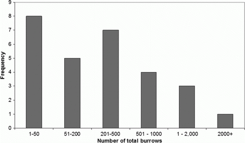
The location and number of burrows was recorded at 28 colonies and ranged from six to 3260 total burrows (). The breeding range covered an area c. 2 km wide and 3.5 km long from the Punakaiki River south to Waiwhero (Lawson) Creek () and the 29 colonies covered 73 ha in total. Eighty-two per cent of the total area covered by the 29 colonies is on conservation land managed by the DOC (). Westland petrels also breed on freehold land held by three different owners, one of these being the Royal Forest and Bird Protection Society of New Zealand. Six colonies were over mixed land tenure between the crown and freehold. The one colony on private land at the southern extent of the breeding range was estimated to have between 200 and 600 burrows following a visit in early 2000s (GCW pers. obs.). Colonies were located on the sides and tops of ridge, with no strong preference for a particular aspect. Most colonies had a nearby accessible take-off cliff or tree where the canopy above was clear. However, for some colonies, the take-off points could not be located. Most colonies had fewer than 50 total burrows, but six colonies had 201–500 total burrows and four colonies had more than 1000 total burrows (). A total of 12,843 burrows were counted in the 28 colonies surveyed. In order to produce an estimate of annual breeding population, burrow occupancy rates were used.
Figure 1 Location of known Westland petrel colonies as numbered in and all other areas surveyed during 2002–2005 and in 2010 and the various land statuses. A, Scotchman's Creek. B, Carpentaria Creek. C, Hibernia Creek. D, Waiwhero (Lawson) Creek.
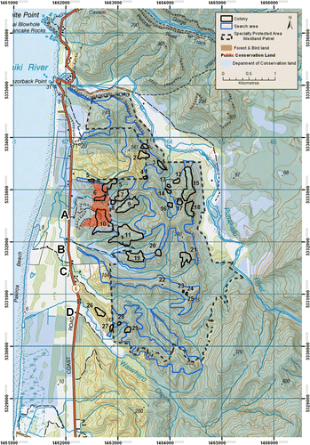
Figure 2 Frequency of colony size of Westland petrels as measured by the total number of burrows.
Monitoring of the same 150 burrows in Scotchman's Creek colony annually between 1997 and 2009 indicated a mean burrow occupancy of 40% (3% standard error of mean, SEM) during the early incubation period. Monitoring of the same 50×10-m transect area in Scotchman's Creek colony annually between 2001 and 2009 indicated a mean burrow occupancy of 23% (2% SEM) during the early incubation period (DOC unpubl. data). An assessment of the breeding status of burrows in three colonies was conducted during the late breeding season to provide an assessment of the variability of burrow occupancy rates between colonies. At Scotchman's Creek colony, 26.6% of the burrows had a live chick, whereas 32.4% and 32% of burrows had chicks at Middle colony and Rowe colony, respectively (mean 30.3±2% SEM). A 2% SEM for colony variability in burrow occupancy is no greater than the SEM of the annual burrow occupancy variability at one colony. It is therefore considered appropriate to extrapolate from the mean burrow occupancy rates at the beginning of the breeding season at one colony to calculate the breeding population. Based on burrow occupancy rates at the beginning of the breeding season between 23% and 40%, the annual breeding population is estimated to be between 2954 and 5137 breeding pairs.
Discussion
The annual breeding population was estimated to be in the range of 3000 to 5000 breeding pairs with almost 19,000 burrows potentially available for use. New Zealand's threat classification system takes into account when assessing species the total number of mature individuals and the population trend, and for threatened species, the area of occupancy (Townsend et al. Citation2008). Westland petrel is currently ranked as ‘At risk—naturally uncommon’ (Miskelly et al. Citation2008) and this is due primarily to the stable demographic rates calculated by Waugh et al. (Citation2006). The information provided by this study does not alter the current threat ranking if the population trend is assumed stable, although it would be appropriate to add the qualifier ‘Range restricted‘.
Location of colonies
Our systematic intensive search over four breeding seasons located 28 colonies. All known colonies and all likely areas where unidentified colonies could reasonably be expected to occur within the Paparoa National Park, other conservation land and land owned by Royal Forest and Bird Protection Society of New Zealand were searched. A total of 29 colonies were identified and the number of burrows at 28 colonies was counted. One ridgeline on freehold land, where Westland petrels may breed, has yet to be surveyed. The current range of Westland petrel colonies and individual colony locations is similar to that reported in the 1950s and 1970s. Jackson (Citation1958) indicated that the breeding range was distributed over 1550 ha, whereas Best & Owen (Citation1976) estimated the breeding area to be 360 ha. In our study, the actual area covered by colonies was 72 ha distributed over an area of approximately 2×3.5 km (i.e. 700 ha). The difference in the breeding ranges among the studies is possibly due to inaccuracies in the topographic maps available when the two earlier studies were conducted.
There are other conflicts in the data, which are possibly due to differences in the time spent searching for burrows and errors. Jackson (Citation1958) conducted his survey work over 2 years and he located six areas with burrows. Best & Owen (Citation1976) conducted fieldwork over a 6-week period and found 21 colonies. Best & Owen (Citation1976) re-located all but one of the colonies reported by Jackson (Citation1958) but could not locate the colony on the ridge between Hibernia Creek and Waiwhero (Lawson) Creek, which Jackson (Citation1958) marked on his map as being at the eastern end of the ridge. In contrast, our survey found four colonies at the western end of this ridge, including one with 209 burrows, but no other colonies were found further east along the ridge. Additionally, Jackson (Citation1958) reported ‘very large concentrations‘ of Westland petrel burrows on the ridge between Carpentaria Creek and Hibernia Creek, however Best & Owen (Citation1976) found two colonies of 12 and 50 active burrows and we found four small colonies close together with 86 burrows in total. Jackson (Citation1958) may have located the ridge between the Carpentaria and Hibernia Creeks in the wrong place in his publication and/or incorrectly marked the location of the large colony, as is the case for some of the terrain and colonies drawn in the northern section of his map.
Change in total population
Nine estimates or indicators of Westland petrel population have been reported by four different authors using a variety of methods, both land and sea based as well as one estimate of the number of birds found in spring/summer off South America (). Jackson (Citation1958) estimated a total population of 3000–6000 birds in the 1950s based on coastal overhead counts and number of colonies. Only Best & Owen (Citation1976) and this study provide an estimate based on counts of burrows at all/most known colonies. Best & Owen counted 818 active burrows (i.e. c. 1600 birds) in Citation1974, but soon after, Baker & Coleman (Citation1977) found this estimate hard to reconcile with their own count of birds seen offshore and the markedly higher estimates provided by Jackson (Citation1958) and Bartle (Citation1974) (). Baker & Coleman (Citation1977) acknowledged that the differences in the estimated population size could be related to a large number of non-breeding birds present during the breeding season and suggested that more precise counts were needed.
Table 2 Reported estimates of population and trend for Westland petrel.
Table 3 The number of active burrows during April–July counted by Best & Owen (1976) and the total number of burrows counted during October–December and estimated active burrows by this study for 11 colonies or colony areas.
Sandy Bartle reported estimates of the total Westland petrel population in five separate publications that appear to be based on specific abundance and demographic studies at Scotchman's Creek colony and burrow counts at other colonies (full results have not been published) (). His estimates range from 6000 to 10,000 birds in 1972, 14,000 birds in 1985 to 20,000 birds in 2000. One estimate stated that the population had doubled over the previous 20 years (Bartle Citation1985b) and in another, he stated that since 1955 the population had been increasing at 5% (presumably per annum as not stated in the publication) up until 1987 (Bartle Citation1987). Other authors have also concluded that the population has increased since the 1950s, peaking in the mid-1980s and has then remained steady (e.g. Taylor Citation2000). Our assessment is that there are no available verifiable data (except Best & Owen Citation1976, which was questioned soon after being published) on which to make an assessment about whether the total population of Westland petrel or the number of breeding pairs has changed between the 1950s and 2000s. However, we note that our estimate of 2954 to 5137 breeding pairs annually is within the range of estimates provided by the various authors ().
Baker et al. (Citation2008) used a different method to estimate the number of total burrows and occupied burrows in each of ten colonies during 2007 and 2008. They used GPS points to map and calculate the area covered by the colony, 2-m wide strip transects of variable length to determine burrow density rates and inspected burrows using burrowscopes, cameras, torches, grubbing and pre-existing inspection lids to determine burrow occupancy rates. The total number of burrows estimated by Baker et al. (Citation2008) for 10 colonies was between 6394 and 6052 (based on three colonies being counted in both years), whereas our count of total burrows for the same 10 colonies was 10,482. However, the estimates of active burrows does not differ markedly, with a total of 2436–3597 active burrows reported by Baker et al. (Citation2008) and 2411–4193 active burrows counted in our study.
There is likely to be a number of reasons why the two methods produce slightly different results, with the Baker et al. (Citation2008) method providing a lower estimate of burrow numbers than our total count. A discussion of the two estimates and the methods used would be valid once Latitude 42 Environmental Consultants Pty Ltd has completed surveys at the other colonies.
Change in colony size
One possible avenue to explore population trend may be determined by examining successive counts made over time at specific colonies. Waugh et al. (Citation2003) reported in 2001 that Scotchman's Creek colony had more than 1000 burrows and Island colony had c. 300 burrows. Our study found 3260 and 363 burrows, respectively. It is also possible to compare the colonies mapped by Best & Owen (Citation1976) with those found in this study. In some cases, counts of burrows in areas with multiple adjacent colonies were combined because our individual colony locations could not be matched directly with those reported by Best & Owen (Citation1976). Best & Owen (Citation1976) counted active burrows between April and July, and for comparative purposes, the total number of burrows counted during October to December in this study was converted to estimated numbers of active burrows, based on the mean occupancy rate of 23% during the early breeding season as determined by the transect monitoring. Five of the colonies (or combined colonies) had considerably more active burrows in 2002–2005 than when counted in 1976, three colonies had slightly more active burrows and two small colonies were fewer active burrows (). If a burrow occupancy rate of 40% was used, even more colonies would be considerably larger in 2002–2005 than in 1976. However, this comparison has limited validity given the counts reported by Best & Owen (Citation1976) were questioned soon after being published by Baker & Coleman (Citation1977) as being very low.
Conservation management of threats
The Westland petrel is assessed as ‘At risk—naturally uncommon’ under New Zealand's threat ranking system (Miskelly et al. Citation2008), but given its small population and very limited breeding range, attention to addressing land- and marine-based threats is appropriate. The birds face threats from interactions with fishing vessels within the marine exclusive economic zones of New Zealand and several South American countries and on international waters, which can affect the population size (Taylor Citation2000; Landers et al. Citation2011). Eighty-eight per cent of the total area of the colonies is on land managed by the DOC and the Royal Forest and Bird Protection Society of New Zealand. The relevant conservation legislation protects the species and its habitat from disturbance, particularly through the requirement to obtain a permit from the DOC to enter the colonies located on crown land and to disturb the species at any of the colonies. Therefore, this legislation should ensure colonies and Westland petrels at colonies are not be adversely affected by human land-based activities. Other key threats include land-based predators (i.e. dogs, cats, pigs and stoats), habitat degradation by deer, pigs, goats and land development (primarily the night-time lighting of the coastal flight path areas).
The DOC is currently concentrating management effort on surveillance for pig and dog incursions to the breeding range, ensuring boundary fences are maintained, raising public awareness of the threats to Westland petrel and assessing interactions with fisheries in New Zealand, Chile and on the high seas in the South Pacific Ocean. Currently, there are a number of initiatives to determine a population trend more accurately for the species and the information from these studies will drive future management actions. It is clear that an accurate picture of the population trend of the Westland petrel is critical to ensure the survival of one of the last seabird species breeding on mainland New Zealand.
Acknowledgements
Many thanks to the following surveyors who assisted with fieldwork: Martin Abel, Sonya Roxburgh, Jane Prendergast, Lisa McArthur, Barry Chalmers, Reuben Lane, Daniel Sawyers, Mark Jones, Bevin Cairns, Nicki Winslade and Robert Schadewinkel. Department of Conservation staff Martin Abel managed the Westland petrel programme, and Liam Anderson and Cielle Stephens produced . Tim Shaw, John Lyall, Paul Scofield, Richard Phillips and Graeme Taylor provided very useful advice for earlier drafts. Jonathon Banks, Amanda Freeman and one anonymous referee helped to improve the manuscript.
References
- Baker , AJ and Coleman , JD . 1977 . The breeding cycle of the Westland black petrel . Notornis , 24 : 211 – 231 .
- Baker B , Cunningham R , Hedley G and King S 2008 . Data collection of demographic, distributional and trophic information on the Westland petrel to allow estimation of effects of fishing on population viability . Report prepared for The Ministry of Fisheries. Hobart, Latitude 42 Environmental Consultants Pty Ltd .
- Bartle , JA . 1974 . Seabirds of eastern Cook Strait, New Zealand, in autumn . Notornis , 21 : 135 – 166 .
- Bartle JA 1985a . Report on research on Westland black petrels 1969–83 with an outline of future objectives and a brief summary of management problems . Unpublished report of the National Museum of New Zealand , Wellington .
- Bartle , JA . 1985b . “ Westland black petrel ” . In Reader's digest complete book of New Zealand birds , Edited by: Robertson , CJR . 91 Sydney : Reader's Digest Services .
- Bartle JA 1987 . Westland black petrel research notes, 10–29/4/87. OSNZ News 44 . P. 5 . Supplement to Notornis 34 .
- Best HA , Owen KL 1974 . Distribution of breeding sites of the Westland black petrel (Procellaria westlandica) . Fauna survey unit; Report No 3 New Zealand Wildlife Service . Wellington , Department of Internal Affairs .
- Best , HA and Owen , KL . 1976 . Distribution of breeding sites of the Westland black petrel (Procellaria westlandica) . Notornis , 23 : 233 – 242 .
- Jackson , R . 1958 . The Westland petrel . Notornis , 7 : 230 – 233 .
- Landers , TJ , Rayner , MT , Philips , RA and Hauber , ME. 2011 . Dynamics of seasonal movements by a trans-Pacific migrant, the Westland petrel . The Condor , 113 : 71 – 79 . doi: 10.1525/cond.2011.100064
- Marchant S , Higgins PJ . 1990 . Handbook of Australian, New Zealand and Antarctic Birds. Volume 1: Ratites to ducks. Part A, Ratites to petrels . Melbourne , Oxford University Press . Pp. 566 – 572 .
- Miskelly , CM , Dowding , JE , Elliott , GP , Hitchmough , RA , Powlesland , RG , Robertson , HA , Sagar , PM , Scofield , RP and Taylor , GA . 2008 . Conservation status of New Zealand birds, 2008 . Notornis , 55 : 117 – 135 .
- Spear , LB , Ainley , DG and Webb , SW . 2005 . Distribution, abundance, habitat use and behaviour of three Procellaria petrels off South America . Notornis , 52 : 88 – 105 .
- Taylor GA 2000 . Action Plan for Seabird Conservation in New Zealand Part A: Threatened seabirds . Threatened species occasional publication no.16 . Wellington , Department of Conservation .
- Townsend , A.J , de Lange , PJ , Duffy , CAJ , Miskelly , CM , Molloy , J and Norton , D . 2008 . New Zealand Threat Classification System manual , 35 Wellington : Department of Conservation .
- Waugh , SM , Cabrera , H , Wood , GC and Davis , LS . 2003 . Burrow occupancy in Westland petrel (Procellaria westlandica) . Notornis , 50 : 123 – 127 .
- Waugh , SM , Doherty , PF , Freeman , AND , Adams , L , Woods , GC , Bartle , JA and Hedley , GK . 2006 . Demography of Westland petrels (Procellaria westlandica), 1995–2003 . Emu , 106 : 219 – 226 . doi: 10.1071/MU05065
- Worthy , TH and Holdaway , RN . 2002 . The lost world of the moa: Prehistoric life of New Zealand , Bloomington/Christchurch : Indiana University Press/Canterbury University Press .