Abstract
Scientific observations and interpretations of the geology of the Wellington Peninsula, New Zealand, during a 55-year period from 1855 to 1910, were made by four geologists; James Coutts Crawford between 1855 and 1885, Alexander McKay between 1872 and 1894, James Hector between 1865 and 1893, and James McIntosh Bell in 1910. Their studies established the foundation to nearly all aspects of Wellington geology, namely. lithology, structure, fossils, age, correlation and distribution of greywacke, Tertiary and Quaternary sediments, regional deformation and peneplanation, the origin of Wellington Harbour, marine terraces, earthquake-uplifted beaches, the moa and its relation to Maori occupation, delineation of faults, in particular the Wellington Fault, and the effects of the destructive earthquake in 1855. These advances are examined in light of our current early twenty-first-century understanding. Published and previously unpublished archival material used in this study reveals a more substantive record of the development of geological thinking by these first geologists than is currently understood and appreciated by the earth science community.
Introduction
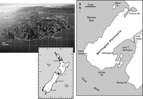
In late September 1839, Ernest Dieffenbach, naturalist to the New Zealand Company sailed from Te-awa-iti in Tory Channel, Marlborough Sounds, north-east South Island, to Port Nicholson (Wellington Harbour). During a stay of 16 days, he recorded observations that provide the first brief description of the physiography and rocks of the Wellington Peninsula, south-west North Island of New Zealand ().
Port Nicholson is situated in a foreland [peninsula] which, in its longest extent, has a north-east to south-east direction… The outermost point of this foreland is Cape Te-re-witi [Terawhiti]… and the general aspect of the foreland, in which the harbour is situated, bears decided proof of wear and tear of the coasts. At the head of the harbour… [is] a triangular space, formed of alluvial land brought down by the river Eritonga, or Hutt…The apex of this delta is about seven miles [11 km] from the beach, where the hills approach each other and form the gorge of the river. At a distance of about forty miles [64 km] a range of hills … shuts in the view. These mountains – the Tararua range – run north and south… The hills which bound Port Nicholson to the westward, and terminate at Cape Te-ra-witi, and those which bound it to the eastward, and terminate at Baring's heads, are branches of the Tararua range. Their geological structure is argillaceous schist, interrupted, especially on the western shore, by bulky and irregular dykes of red black, or greenish Lydian stone [basalt jasper]. Sometimes the clay [clay slate] is more quartzose and granular… Notwithstanding the very early formation of these schistous and trappean rocks, shocks of earthquakes are sometimes felt at Port Nicholson. They are generally very slight… The boundary hills, both to the east and west of the basin of Port Nicholson, rise abruptly from the water's edge: but in that peninsula part where the town of Wellington has been founded, there is a strip of flat land at their base … consisting of soil composed of sand, shells, shingle, and vegetable earth, and extending to the western headland of the harbour where the hills are low and undulating [Miramar peninsula]… (Dieffenbach Citation1843).
Figure 1 Oblique aerial photo looking north along the Wellington Peninsula and harbour, and map of the Wellington Peninsula with place names referred to by Dieffenbach (1843) (photo: DL Homer, GNS Science).
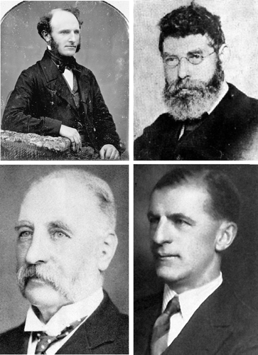
Dieffenbach's observations set the scene and were just the beginning. The substantive foundations for understanding the geology of Wellington Peninsula were largely due to the observations and ideas of two men—James Coutts Crawford (1817–1889) and Alexander McKay (1841–1917). Crawford (), a naval officer, farmer, natural scientist, explorer and public servant, arrived in New Zealand in 1839, settling on Miramar peninsula () in 1840 before being appointed Wellington Provincial Geologist in 1861, a post which he held until 1864. Alexander McKay (), self-taught and a legendary figure in New Zealand geology, arrived in Wellington in 1873 as assistant to Sir James Hector, Director of the Geological Survey, where he was to remain until being transferred to the Mines Department as Mining Geologist in 1892. Between 1855 and 1892, Crawford and McKay published 25 papers that touched on most aspects of the geology of Wellington. As provincial geologist, Crawford's work initially appeared as reports to the Wellington Provincial Council, but from 1868 his papers were published in the Transactions of the New Zealand Institute which began in the same year. McKay also published in the Transactions but most of his work appeared in the New Zealand Geological Survey Reports of Geological Explorations published annually. Two other scientists who contributed to late nineteenth and early twentieth century developments in the geology of Wellington were Sir James Hector and James Abbott Mackintosh Bell (). Hector, who was appointed Director of the New Zealand Geological Survey in Wellington in 1865, did not publish anything specific about Wellington geology, but he directed and edited McKay's work and provided commentary, clarification and summaries of this in his yearly Progress Reports. Bell was a 27-year-old Canadian who arrived in Wellington in 1905 to take over McKay's position in the Mines Department, but was instead (after renegotiation) appointed Director of the Geological Survey that had been in recess since 1893. Bell's 1910 paper on the Physiography of Wellington Harbour can be regarded as marking the beginning of geomorphological studies of the Wellington Peninsula.
Figure 2 Photographs of Wellington-based geologists. Upper: left, James Coutts Crawford (1817–1889), Wellington Provincial Geologist (1861–1864) (photographer George Popowitz, 1849–1856; No. PA10–08–01, Crawford Family Collection, Alexander Turnbull Library, National Library of New Zealand); right, Alexander McKay (1841–1906), Assistant geologist, New Zealand Geological Survey (1873–1892) (Cyclopedia of New Zealand (Wellington Provincial District) 1897, Wellington, Cyclopedia Company Limited); Lower: left, Sir James Hector (1834–1907), Director of New Zealand Geological Survey (1865–1892) (photographed from framed photo; Institute of Geological and Nuclear Sciences Ltd.); right, James Abbott Mackintosh Bell (1877–1934), Director of New Zealand Geological Survey (1905–1911) (photographed from framed photo; Institute of Geological and Nuclear Sciences Ltd.).
To most earth scientists, the geology of Wellington Peninsula is regarded as somewhat ‘difficult’ due to the relatively intractable nature of the dominant basement greywacke rocks, the lack of coherent mappable stratigraphy, absence of fossils, complicated structure, and the lack of any significant economic resource potential in terms of mineral wealth. This account demonstrates how the early geologists made sense of it all, namely, lithology, age, structure, correlation and distribution of greywacke, Tertiary and Quaternary sediments, regional deformation and peneplanation, the origin of Wellington Harbour, marine terraces, earthquake-uplifted beaches, the moa and its relation to Maori occupation, delineation of faults, in particular the Wellington Fault, and the effects of the two destructive earthquakes in 1848 and 1855. It also evaluates the extent to which they were correct or on the right track. Above all it offers a fascinating insight into what exercised their minds at the time, and why, and it shows how liberal and open-minded they were in their thinking as Victorian natural historians.
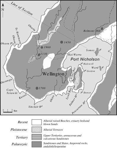
In addition to information contained in published work between 1840 and 1910, we have used unpublished material of Crawford (Crawford Family Papers) and reports written by McKay in 1872 and 1879a that contain information not used in his 1879b paper The geology of the neighbourhood of Wellington. Except for a geological map of the Wellington Province produced by Crawford (Citation1864) (), and a sketch map of Miramar peninsula (1873), none of the reports and papers of Crawford or McKay contains geological or locality maps, and we have compiled these from information provided in the various texts, augmenting this with information from the Wellington geological map of Begg and Mazengarb (Citation1996). Discussion of gold mining activities on the Wellington Peninsula, e.g. mainly at Terawhiti, between the Citation1860s and 1915, are not included in this account, but details can be found in Aitchison-Windeler (Citation1973) and Brodie (Citation1986).
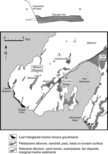
Figure 3 First geological map of the Wellington Peninsula (reproduced from Crawford 1864a; Geological Sketch Map of the Province of Wellington). Dashed lines = roads; hill heights in feet. Geology along the Line of Section is shown in . Scale and North direction are inserted.
Greywacke
The first mention of the greywacke rocks at Wellington (and the Marlborough Sounds) was made by Dieffenbach (Citation1840, Citation1841), who termed the rocks ‘yellow clay slate and greywacke’, and ‘slate, siliceous slate, argillaceous slate, argillaceous schist and clay slate, often with Lydian stone, basalt and greenstone (Dieffenbach 1843, Appendix II). In the absence of fossils, Dieffenbach correlated the greywacke with the Transition Series of Abraham Gottlob Werner (1749–1817), father of the Neptunian theory of the origin of rocks and Professor of Mineralogy at the Mining Academy, Freiburg, Germany. Rocks of the ‘Transition Series’ were characterized by lithology, mode and age of deposition, and were stratigraphically positioned between unfossiliferous, crystalline (primitive) and younger or secondary stratified (flötz) formations of the Earth, because they consisted of a mixture of mineral and flötz-like rock fragments (clastics) enclosed in a slaty cement (matrix), the unstratified nature of which was thought to be typical of rocks of the primitive formation (Werner Citation1786). Werner's ‘grauwacke formation’ also contained trap rocks (basalt or ‘spilite’), chert and limestone, an association (together with serpentinite) recognized by Gustav Steinmann (Citation1905) as characteristic of the axial part of a deep ocean geosynclinal environment, and later termed the ‘Steinman Trinity’.
In 1848, Crawford described the Wellington greywacke:
The shores of the harbour [Port Nicholson] are bounded by a range of mountains, having a height of from 500 feet [152 m] to perhaps 2,500 feet [762 m] in the centre of the range. The direction of the range is from about NNE to SSW. The formation is metamorphic, and is called greywacke by my cousin Dr. Monro of Nelson, who is the most competent judge I have met with in the Colony. This range rises into abrupt mountains forming precipitous and narrow gorges, strata broken, contorted, and at all angles, frequently perpendicular and often so altered that the stratification is doubtful. The rock is frequently of a siliceous texture, sometimes clayey and often passes into fine quartz, when struck by a hammer it breaks into angular fragments the size of road mettle or is intersected by numerous veins of igneous rock, but there is no appearance of lithic lava which may have flowed on the surface, or granite reefs, and no fossil remains have as yet been detected in it. (Crawford Family Papers and also reproduced in part in Crawford Citation1855)
Ferdinand von Hochstetter, with whom Crawford communicated on the geology of the Wellington area, providing him with specimens of ‘quartzose clay slate, greywacke-type sandstone, clay slate and red jaspilitic siliceous slate’, regarded the age of the greywacke as Paleozoic (Hochstetter Citation1864). He also records that Julius von Haast, who visited Wellington in December 1859, described the greywacke-sandstone there as forming ‘thick beds 10–50 ft [3–15 m] thick, which alternate with thinner clay slate beds’.
Dieffenbach, Crawford and Hochstetter correctly use the term ‘greywacke’ to describe the low-grade metamorphosed sedimentary rocks that constitute the Wellington Peninsula, and a sketch map of New Zealand published in 1860 by Charles Heaphy indicates the presence of ‘clay-slate and wacke’. Crawford understood ‘grauwacke’ in terms of the age-related system established by Werner and believed that we must be ‘content’ to call the ‘semi-metamorphic’ rocks in the main range of the Island ‘grauwacke … until the discovery of fossils shall enable us to assign... a definite geological age’ (Crawford Family Papers). However, after 1860, ‘greywacke’ disappeared from the New Zealand geological literature and was replaced by ‘sandstone and slate’. Crawford never actually used ‘greywacke’ in his publications and nor did McKay. The reason may have been due to the English aversion to the name ‘grauwacke’—considered an uncouth, foreign vernacular name that was also nomenclaturally confusing because it referred to both a rock type and to a time of formation (Nicholson Citation2003). Professor Adam Sedgewick and Roderick Murchison, leaders in British geology, came out forcefully against ‘grauwacke’ and encouraged others to abandon the term, with the result that after 1840 greywacke dropped out of common use in England, although not in Scotland (Nicholson Citation2003). James Hector, sent out to New Zealand in 1862 on Murchison's recommendation, presumably carried with him a prejudice against greywacke and continued it as Director of the Geological Survey in Wellington and as editor of the Transactions of the New Zealand Institute (from 1868). The term returned to the Wellington rocks as ‘grauwacke’ with Bell in 1910.
In his Geology of the Wellington Province of 1868, Crawford considered the age of the Wellington greywacke as ‘possibly secondary or palæozoic’, and ‘probably silurian’ (), and he correctly surmised that the rocks decreased in ‘geological age from west to east’ (Crawford 1869b). The earliest attempt to subdivide the Wellington greywacke in terms of age and lithology was made by McKay in 1872 along ‘… a portion of the shore of Cook's Straits with the object of discovering fossils which might determine the age of the slates and sandstones which form the ranges between Wellington and Cape Terawiti’ (; ). Following additional surveys in May of 1879, McKay modified this subdivision and produced a rough cross section of the coastal exposure between Sinclair Head and Terawhiti () (McKay 1879a,b) (). In 1888, McKay presented a final revision after he had examined the rocks of the Rimutaka and Tararua Ranges, in which he concluded that the greywacke was not younger than Triassic or older than Lower Carboniferous / Upper Devonian ().
Figure 4 Cook Strait coastal sections of the Wellington Peninsula after Crawford (1864a) (south Wellington coastal section between Cape Terawhiti and Sinclair Head projected onto the section line shown in ) and McKay (1879a), compared with that of Suneson (Citation1993).
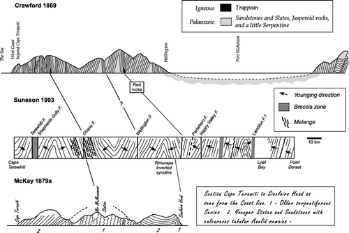
Table 1 Age and lithologic divisions of the Wellington greywacke
a. Devonian?-Carboniferous greywacke
The oldest rocks, considered to be Devonian by McKay (1872, 1879a,b) and Lower Carboniferous (lower Maitai or Rimutaka series) by Hector (Citation1879) and McKay (Citation1888b) (), comprised steeply dipping, ‘much jointed and usually highly contorted’ sandstones with green and black shales in the core of a regional anticline exposed on the coast between Sinclair Head and Terawhiti (, ). Hector (1879) characterizes the rocks as ‘hard grey or green, and sometimes red, much jointed slates and sandstones, with black, drossy, serpentiferous shales’. Numerous ‘strings and small leaders of quartz’ were usual and sometimes gold-bearing. In other places barren reefs of quartz were present.
Figure 5 Map showing lithological and age divisions of the Wellington greywacke (after McKay 1879a,b; 1888). Localities of fossil plants from Crawford (1864b, 1869b) and McKay (1879a). ‘C’ = section at Pauatahanui Inlet where plant fossils were first found by Crawford in 1863. Localities of Torlessia mackayi from McKay (1879a,b, 1894). Distribution of semischistose greywacke (=?Devonian—Lower Carboniferous rocks of McKay 1879a) is after Begg and Mazengarb (Citation1996).
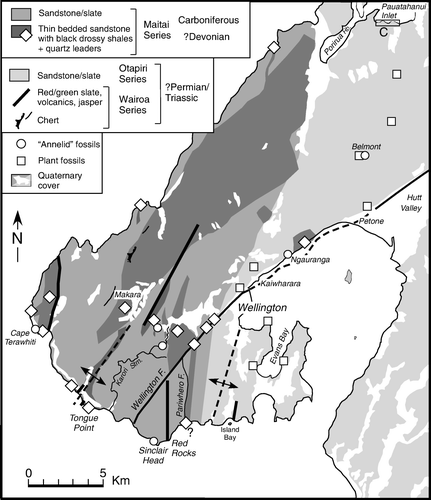
The rocks were thought to be developed along three north to north-east-striking ‘axial lines’—one extending inland from the coast north across Terawhiti Hill, another extending north-east from either side of the mouth of Wairaki Stream (west of Tongue Point) and across Makara Valley, and another extending NNE from the coast east of Sinclair Head (). Localities where these rocks were observed by McKay () indicate that they coincide with outcrops of semi-schistose (textural zone IIA) greywacke mapped by Mortimer et al. (Citation1993) and Begg and Mazengarb (Citation1996) (a), the crush zone of the Wellington Fault, and the silicified crush zone of the Pariwhero Fault (at the coast) and other unnamed faults near to where they join the Wellington Fault ().
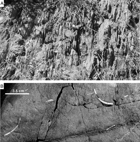
Figure 6 A, Schistose greywacke regarded by Crawford (1868), Hector (1869) and MacKay (1879a,b) as the oldest greywacke (Devonian?—Lower Carboniferous) of the Wellington Peninsula. Wrights Hill car park, Karori (Photo: S Eagar). B, Tube fossils of Torlessia mackayi preserved on a bedding plane in dark grey argillite from Sinclair Head, and probably the same locality mentioned by McKay (1879a). Greywacke containing the tube fossils was regarded as Carboniferous by McKay (1879b), but is now considered to be Triassic (photo: John Simes, GNS Science).
Crawford (1869b) had also characterized the ‘old rocks’ at Terawhiti as ‘slaty rock, laminated with veins of quartz; of the usual hard green crystalline sandstone, veined with thin threads of quartz, and some hornstone or chert, and some serpentiferous rocks’. He noted that the ‘same rocks, or some of them’ could be found ‘near the Printers Flat in Makara; at various points on the Karori Road; between Ngahauranga and Pitone’ (). Hector (Citation1869), who was primarily concerned with gold deposits in the area, described the junction between the ‘Primary slates, shales, and sandstones’ and the younger greywacke:
though both are generally found in a vertical position, the line of junction between them is well marked. The district has been traversed by a series of dislocations which cross the lines of stratification in oblique lines [faults]. The consequent displacement appears to have indurated the sandstones, and altered the shales, when in contact with them, into friable cherty slates of a deep blue colour, traversed by thread-like veins of quartz. The altered sandstone is slightly micaceous, and has been so infiltrated with silica, that the specimens have been mistaken for granite.
Hector's description refers to the distinct boundary between non-foliated and schistose textural zone IIA greywacke that crosses Terawhiti Hill (). The slightly micaceous nature of the silicified sandstone and its granitic appearance echoes an earlier idea of Crawford (Citation1861), who thought that these rocks had been ‘nearer to the central fires’ so that they became more crystalline and were ‘traversed by veins and possibly transfused with gold’. The veins in the blue cherty slate as the probable source of a small quantity (about 80 ounces in 1869) of ‘fine grained rough, unworn’ gold that had been found (Hector 1869).
b. Carboniferous greywacke and fossils
According to McKay (Citation1879a), the coastal exposure of the Carboniferous greywacke comprised ‘hard grey, much jointed sandstone and some thin beds of conglomerate’ that were unconformably underlain by the Devonian greywacke west of Sinclair Head and then reappeared towards Cape Terawhiti (, 5). Like the older greywacke, the Carboniferous rocks were ‘…traversed by numerous small leaders of a grey flinty quartz and at places by larger veins which in one place in Makara have been prospected for gold’ (McKay Citation1879a). In 1888, McKay grouped the Devonian and Carboniferous greywacke together as part of the Carboniferous Maitai Series (). The Carboniferous greywacke was initially thought to include red and green slates (McKay Citation1872, 1879a,b), such as those at Red Rocks, but these were later grouped with diabase, ‘ash beds’ and chert as part of the Wairoa Series of Triassic age (McKay 1888b) ().
In the ‘earthy slates’ (argillite), McKay found rare occurrences of ‘a peculiar fossil known as the Mount Torlesse Annelid’ (Torlessia mackayi Bather 1906) (b), ‘… on the coast a little west of Sinclair Head and at Cape Terawiti’ which he had previously identified inland towards Wellington (headwaters of Karori Stream) and on the shores of Port Nicholson between ‘Kaiwara and Lower Hutt’ (). These occurrences were comparable with the same fossil in rocks at Mt. Torlesse, Canterbury, as ‘…consisting of a straight calcareous tube seldom more than two inches [5 cm] in length, often divided into several joints but this condition scarcely appears to have been the natural condition but to have been an after result, nor is it present in all the specimens’ (McKay Citation1879b). ‘Vermiform castes of indistinct character’ in the greywacke were also mentioned by Crawford (Citation1876), e.g. at Belmont Hill () where ‘Theca or Dentalium’ and probable ‘Tentaculites’ were found (Crawford 1869b), these fossils, with Dentalium in particular, superficially resembling the Triassic tube fossil Titahia corrugata (Webby Citation1967). Hector (1879) noted that ‘the beds in which this fossil occur have hitherto been referred to the Maitai Formation; but, it appears that this must be broken up into an upper and lower series…with the Wellington deposits…regarded as Upper Maitai; Lower Maitai comprising all rocks from the fossiliferous limestones at the base of the Maitai slates [as characterized at Nelson by Hochstetter 1864] downwards’. The tubular ‘worm’ fossil Torlessia mackayi in the Wellington greywacke is now equated with the agglutinated foraminiferal family Bathysiphonidae rather than to the annelid family Terebellidae (e.g. Hannah and Collen Citation1995; Hannah and Campbell Citation1996), and is regarded as indicating a Middle-Late Triassic age (Campbell et al. Citation1993).
c. Permian?—Triassic rocks
Greywacke and fossils
McKay's youngest greywacke rocks (Old Sedimentary or Permian; Triassic or Permian; Triassic; ) comprised ‘…coarse sandstones, which weather to hard concretionary boulders and decompose to a soft brown rock. With these are associated slaty shales and fine-grained sandstones’. In places, he considered that ‘…the beds make a near approach to the characters of the Monotis sandstone both in Nelson [Wairoa Gorge in his 1879b paper] and Southland but as a rule they are as close in their resemblance to the Kaihiku Series as developed in many places. There is in the Wellington deposits an almost total absence of the crystalline conglomerates which so significantly distinguish both the Wairoa [Triassic] and the Kaihiku [Permian] Series of rocks in most localities in which they occur’ (McKay Citation1879a).
Some of the greywackes contained fossil plant impressions. These had first been found associated with ‘carbonised substances’ by Crawford in 1863 in a c. 244 m thick section of vertically dipping sandstone and slate ‘strata’ on the shore platform of Pauatahanui Inlet, Porirua Harbour (). The plant impressions occurred in some six beds ‘of various width of from fourteen [4.3 m], to two or three feet [0.6 to 0.9 m]; and with the associated shales and sandstones they make a thickness of at least 800 feet [244 m]’. Crawford had hopes of using them to establish the age of the rocks, but the impressions ‘proved too indistinct and obscure to give any definite information’. Examining further outcrops along the line of strike of the strata southeast from Pauatahanui Inlet, ‘similar organic substances’ were discovered in exposures on the Belmont Road (in ‘soft sandstone’) and at Oriental Bay, Wellington, and other unspecified places ‘within the limits’ of Wellington (Crawford Citation1864b, Citation1869b), but he was unable to ‘decide whether they were of terrestrial or marine origin’ (Crawford Citation1876). Crawford submitted samples of sandstone containing plant impressions along with others, to Melbourne, Australia, for further identification. He received a reply on 14 February 1863 stating that according to Professor Frederick McCoy (University of Melbourne) they were probably of Mesozoic age and equated with the ‘upper beds of the Australian Newcastle coal seams’, whereas the associated shale or ‘mudstones being declared Palaeozoic and probably Silurian, it follows that we have sedimentary rocks of two eras in these ranges, folded however together in such a way that I foresee great difficulty in drawing the line of demarcation’ (Crawford 1863). A subsequent and different age identification was received on 05 January 1864 from WB Clarke in Sydney. Reverend William Clarke, a geologist and Anglican clergyman acknowledged as the father of Australia geology, was involved in an increasingly acrimonious controversy lasting some 30 years with Professor McCoy over the age of the New South Wales coalfield. According to Clarke, the Porirua specimen ‘resembles very much the stem of Phyllotheca, but it may be that of a fern. If the former it would bring the deposit near to one of our New South Wales beds in the coal series, probably the upper’, which Clarke considered to be Paleozoic (Carboniferous). Regarding another sample from Belmont, Clarke wrote; ‘Apparently an upper Silurian rock with Dentalium, or Theca, and caste of worm track, as in the May Hill sandstone of Heidelberg, Victoria’, with additional information that ‘Theca belongs to Carboniferous and Silurian formations. Dentalium goes as low as Carboniferous’ (Crawford Citation1864). Being satisfied that the Wellington greywackes containing the plant impressions were of probable Carboniferous age, Crawford contemplated the possibility of finding ‘workable coal seams amongst them’, as in New South Wales.
Fifteen years later, McKay (Citation1879a) noted that fossil plants had been ‘diligently searched for by various collectors’ but without success. John Buchanan, botanist and draughtsman of the Geological Survey, made several unsuccessful attempts to obtain distinct specimens from Point Jerningham (then known as Powder or Magazine Point) forming the eastern headland of Lambton Harbour, Wellington, and presumably the same locality reported by Crawford at Oriental Bay. According to McKay, this was the best known locality in Wellington, and he also mentions that plant impressions had been found on ‘spurs of the hills bounding the town [Wellington] to the N.W. and are exposed in the road cuttings leading from Tinakori Road to Wadestown—also according to Mr. Crawford's report near Petone west of the Hutt Road’, and that they ‘…are also present in the saddle leading from Newtown to the Patent Slip at the head of Evans Bay’ (McKay Citation1879a) (). However, despite determined efforts to locate diagnostic specimens, the fossil plant material is poorly preserved and cannot be identified, and is therefore of little stratigraphic importance.
Volcanics, chert and coloured argillite
Crawford's 1869 cross section of the Wellington Peninsula shows the occurrence of basaltic rocks (termed ‘trappean’ [Crawford 1869b], or ‘vesicular trap’ [Crawford Citation1876]) at Red Rocks and near Tongue Point (). The coastal Red Rocks outcrop () is the best exposed locality in the Wellington Peninsula and the stratigraphy was described by McKay (Citation1888a) as consisting: ‘…of grey, red and green slates, the green and red colours over a thickness of some 30 ft [9 m], … Succeeding these are grey and red cherts, 15 ft [4.6 m] to 20 ft. [6 m] thick [‘the bands being curiously contorted’; McKay 1888b]; a flinty jasper rock, veined yellow and white [‘25 ft to 30 ft thick’; McKay 1888c]; and a varying thickness of rather remarkable rock consisting of a mixture of granular limestone, serpentine, and brown jasperoid rock [‘the total thickness of all these rocks, including the quartzites, was about 300 ft (91 m)’; McKay 1888c]; beneath which on the western side, there is a varying thickness of a finely-crystalline volcanic rock, of a leek-green colour, in which numerous cavities of irregular form have been filled with carbonate of lime’. He considered that the sequence younged to the east.
Figure 7 McKay's (1888b) section at Red Rocks compared with that of Broadgate (1916; cliff exposure), Wellman (Citation1949) and Grapes et al. (Citation1990); shore platform section).
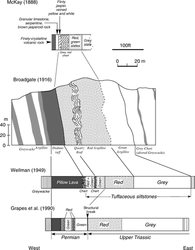
It is not easy to correlate McKays’ description with the sequence mapped by Broadgate (Citation1916), Wellman (Citation1949) and Grapes et al. (Citation1990) (), but the flinty jasper rocks, veined with yellow and white, the rock consisting of a mixture of limestone, serpentinite and brown jasper, and the finely-crystalline volcanic rock, presumably refer collectively to the diabasic tuff of Broadgate and the basaltic pillow lava identified by Wellman and Grapes et al. The basalt is a dark reddish-purple colour and is transected by yellow (epidote), green (chlorite/pumpellyite = McKay's serpentine?) and white (calcite) veins, with interpillow carbonate segregations (= McKay's granular limestone?). The whole section youngs to the west, not east as postulated by McKay, and is overturned.
McKay also found a similar basaltic rock in Makara Valley (). He originally thought that this was a dyke, but after examining the finely crystalline volcanic rock at Red Rocks concluded that the both occurrences represented lavas erupted contemporaneously with greywacke deposition (McKay 1888a). He also reported that ‘cherts, red and green rocks are three times repeated between the entrance to Wellington Harbour and Cape Terawhiti’ because of folding (McKay 1888b), and these occurrences presumably refer to the outcrops at Island Bay (Brodie Citation1953; George Citation1985), Red Rocks, and near Tongue Point (Grapes et al. 1992; Barlow Citation1997) and their supposed continuation to Makara and further to the northeast (Broadgate Citation1916) ().
As mentioned above, McKay (1879a,b) initially correlated the red and green argillites, or slates as they were termed, with the red and green slates in the Maitai Valley, Nelson, and grouped them as part of the Maitai Series of Carboniferous age (). However, in 1888 he had doubts about the correlation based on the occurrence of red and green slates associated with greywacke in the Canterbury area (Malvern Hills, Ashley Gorge, Glentui and upper Okuku Rivers) where limestone associated with ‘diabase-ash beds, red slates, and quartzites’ contained the Triassic fossils Monotis salinaria and Mytilus problematicus. No fossiliferous limestone had been found in the Wellington greywacke although limestone associated with basalt, red and green slates and chert was known from greywacke at Eketahuna in northern Wairarapa and McKay expressed hopes of recovering fragments of Monotis from the limestone (McKay Citation1889). This was not to be, and Monotis richmondiana was first discovered in impure limestone within the greywacke some 40 miles north of Wellington at Otaki Gorge, Tararua Range, by Grant-Taylor and Waterhouse (1963) establishing a Late Triassic (Monotis zone) age of the Wellington greywacke (e.g. Grant Taylor & Waterhouse 1963; Speden 1976). This age has been confirmed by the occurrence of Late Carnan to Middle Norian radiolarian fossils in phosphorite lenses within argillite beds at several localities along the south Wellington coast (Grapes et al. Citation1990; Grapes and Campbell Citation1994).
Based on the similarity with the Canterbury lithological assemblage, McKay placed the Red Rocks association and other red and green slates in the Wellington greywacke within his Wairoa Series of Triassic age (). A Late Triassic age for the grey argillite at Red Rocks has been confirmed by the hyrozoan Heterastridium cf.) (Grapes et al. Citation1990; Grapes and Campbell Citation1994). Radiolaria from chert associated with the basalt and red argillite indicate a Permian age implying that this part of the sequence represents a slice of ocean crust tectonically emplaced within the Triassic age greywacke (Grapes et. al. 1990).
d. Paucity of fossils in the greywacke
In 1876, Crawford conjectured about the lack of fossils in the ‘older Paleozoic’ slate and sandstone of Wellington and elsewhere, e.g. the Tararua and Ruahine ranges. He considered that although the rocks had been deposited in regular parallel strata of great thickness, the sandstone and slate layers were ‘extremely irregular’ in that the sandstone and slate commonly merged, thinned, thickened, mixed and were heavily jointed causing the rocks to break into angular pieces so that ‘very little solid rock within the whole area… can be used for building purposes’. He explained the irregular structures as a result of their mode of deposition, ‘in a sea agitated by rapid, conflicting, and changing currents’, creating conditions that would have been ‘…unfavourable to the growth of animal life; and destructive, during the process of deposition, to such life as might exist’—a description that reflects the conditions of their turbidity current origin proposed by Brodie (Citation1953), Reed (Citation1957) and Webby (Citation1959, Citation1967), although Crawford did not recognize the effects of subsequent tectonic deformation.
Tertiary rocks
a. The Makara occurrence
The earliest mention of fossiliferous rocks in the Wellington Peninsula was by Crawford (1863); ‘at Makara there is a fossiliferous patch, probably marking an old sea beach’ which he regarded as ‘Recent’. By 1869, he had revised this idea when he correctly depicted the Makara rocks as ‘Tertiary’ on his geological sketch map of the Wellington Province (). In 1869, Hector, presumably also referring to the same Makara occurrence, commented (erroneously) that some of the intervening valleys in the country near Cape Terawhiti ‘are occupied by marine tertiary strata’.
The Tertiary rocks at Makara were briefly examined by McKay in Citation1877, who characterized them as fine-grained conglomerate with ‘a considerable number of broken shells and fragments of corals’. However, he was able to obtain ‘fragments of a thick-shelled oyster, some castes of Waldheimia [brachiopod], and two kinds of coral’, all of which he had found in the ‘Napier and Castle Point beds’ on the east coast of the North Island, which he regarded as Miocene (McKay Citation1879a). The massive type of oyster, indeterminate shell fragments, and the degree of induration of the matrix led John Marwick of the Geological Survey to suggest a Pliocene age (Gage 1940), and an Early to Middle Pliocene age (5–4 Ma) is now confirmed on the basis of foraminiferal, nannofossil and macrofossil evidence (summarized in Begg & Mazengarb Citation1996). According to McKay's (1879a,b) age and lithological division of the Wellington rocks, the Pliocene is incorrectly assumed to comprise ‘conglomerates and sandy clays’ and ‘coastal terraces along the shore of Cook Strait’ (see below), and oddly his scheme does not include the fossiliferous Miocene rocks he had previously identified at Makara.
b. Tertiary rocks, regional deformation and peneplanation
A theory of submergence, uplift and regional tilting to explain geological features of the southern North Island and to explain why there were no Tertiary rocks, except for the small outlier at Makara, overlying Wellington greywacke was proposed by Crawford (Citation1873). His theory was formulated following a remark and question from Sir James Hector regarding Crawford's paper on Miramar Peninsula delivered at the New Zealand Institute (Crawford Citation1873), namely ‘that the particular denudation of the Miramar Peninsula was difficult to account for under the present conditions [which] gave him [Hector] the idea that it was formerly the summit of a mountain’ with the question, ‘had [Crawford] observed any signs of marine remains in this locality higher than a height of about fifteen feet [4.6 m] above the sea?’, to which Crawford's answer was that he had not. In his explorations of the Wellington Province in 1869, an area that covered the southern part of the North Island, Crawford noted that marine Tertiary rocks (Eocene to Pliocene) overlying greywacke on the flanks of the Tararua, Ruahine and Kaimanawa Ranges increased in height from 400–500 ft (122 to 152 m) in the vicinity of the Manawatu to 2700 ft (823 m) in the Kaimanawa. He reasoned that prior to and during deposition of the Tertiary sediments the greywacke surface in these places was depressed relative to greywacke in the Wellington area which, in contrast, may have stood at ‘… a great elevation, possibly equal to the present extreme altitude of the Tararua, viz, 5,000 to 6,000 feet [1500 to 1800 m], perhaps higher’, and at that time ‘… it is reasonable to suppose that Cook Strait did not exist, and that the islands [North and South] were united’. Subsequent uplift that exposed the Tertiary rocks must have also involved regional tilting but with increasing height toward the north, whereas the Wellington area was submerged ‘below its present level [i.e. 4.5 m], and probably at the same time Cook Strait was formed and the islands separated’. The idea that the North and South Islands had been joined until geologically recent time had been surmised by Dieffenbach in 1843; ‘The outermost point of this foreland [Wellington Peninsula] is Cape Te-ra-witi. This is the narrowest point of Cook's Straits [now called ‘The Narrows’], the distance to the nearest land in the middle island being only thirty miles [48 km], and it can scarcely be doubted that formerly both islands were here connected. The sea having once broken through this connection, a rush of tide, which comes from the southward, and runs at a rate of five knots an hour during spring-tides, took place through the opening’. By analogy with the Manawatu Gorge through the Tararua Range, Crawford (Citation1875a,b) considered that ‘a large [eastward-flowing] river first denuded and weakened the channel, by forming a valley, which permitted the sea afterwards to complete the work thus begun’. He also cited evidence of the flightless birds, kiwi and weka, and in particular the remains of the extinct moa, throughout both islands indicating that they must have been joined between Terawhiti and Queen Charlotte Sound until a geological recent time (‘no distant date’) (see also Te Punga Citation1953), which proved that there must have been a Cook Strait river and that Port Nicholson was a freshwater lake (see below). According to Lewis et al. (Citation1994), the first breaching of a narrow land bridge between the North and South Islands and tidal scouring to produce a proto-Cook Strait could have associated with a Mid-Pleistocene interglacial sea level high at c. 450 ka.
Although Crawford mainly considered that changes in elevation were caused by uplift or submergence of the land, he did consider the possibility of a eustatic rise in sea level; ‘At the time when a large part of Europe emerged from the ocean, a corresponding quantity of water must have been displaced. It is by no means unreasonable to suppose that this may have passed to the southern hemisphere, and drowned out some of the southern islands…Possibly this theory may give a clue to the date at which the great Cook Strait River existed’ (Crawford Citation1875a).
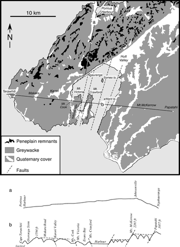
The idea that a major erosion event had removed younger sediments overlying the greywacke was also considered by McKay (1879a) and Bell (1910) (). McKay thought that the preservation of Tertiary rocks at Makara was due to ‘their being so placed as to escape the full force of the denuding agents which have swept every vestige of these beds from the rest of the neighbourhood’. According to Bell, the flatish remnants of this erosion surface represented a peneplain although ‘the peneplain, as its name implies, was not absolutely a plain, but doubtless owing either to original greater resistance in composition, or possibly a favourable position free from attack by erosive agencies, a few hills remained above the general denuded surface’. He also recognized the importance of vertical displacement on faults that transected the Wellington Peninsula, based on differences in relative heights of the peneplain surface (a). As with Crawford, Bell envisaged that post-early Mesozoic uplift and concomitant erosion of the deformed greywacke undermass of Wellington Peninsula had created a low, hilly, or even mountainous topography, although the absence of glacial debris indicated that the elevation was below snowline level, following which erosion had reduced the land to sea level producing a peneplain. In the Late Tertiary, the area was again elevated, or ‘relatively elevated, with regard to the sea’, possibly aided by block faulting, when the known faults transecting the Wellington Peninsula were formed.
Figure 8 Map showing the remnant peneplain surface of the Wellington Peninsula (after Ota et al. Citation1981; Begg and Mazengarb Citation1996), cross sections (a and b) and faults from Bell (Citation1910).
The age of the peneplain (named the Key or K-surface by Cotton in 1912) is not known, but if the Makara Pliocene sediments overlie the peneplain surface, it must be older, at least in the Makara area. Eocene-Oligocene sediments overlie a similar greywacke surface near Paraparaumu, about 20 km to the north of Makara (Macpherson Citation1949), indicating that the peneplain is diachronous. These Tertiary sediments had been noted by Crawford (Citation1865), who mentions ‘…the junction of the Tertiary and Palæozoic rocks, near Paekakariki…’, and was presumably referring to the same locality described by Macpherson (Paekakariki is some 7 km SE of the Tertiary outcrop at Paraparaumu).
Pleistocene deposits, a freshwater lake, marine terraces
a. Boulders, water-worn pebbles, conglomerates and sandy clays
The earliest report of conglomerate overlying the Wellington greywacke was by Crawford (Citation1869a), who mentions ‘boulders which are of considerable size’ found at numerous places such as Belmont, on the Porirua Road, at Pauatahanui Inlet and Makara, and described as ‘large blocks of dioritic [in Crawford 1885 ‘dioritic’ is changed to ‘coarse’] sandstone apparently deposited in lines, and generally resting upon decomposing sandstones’. Crawford conjectured that such boulders either represented the ‘hard nuclei of strata, the softer parts of which have decomposed, that they represented old watercourses ‘before denudations had worn down the valleys to their present depth’, or were erratics deposited by ice. What Crawford described was the periglacial solifluxion debris later identified by Cotton and Te Punga (Citation1955) and Stevens (Citation1957) (b).
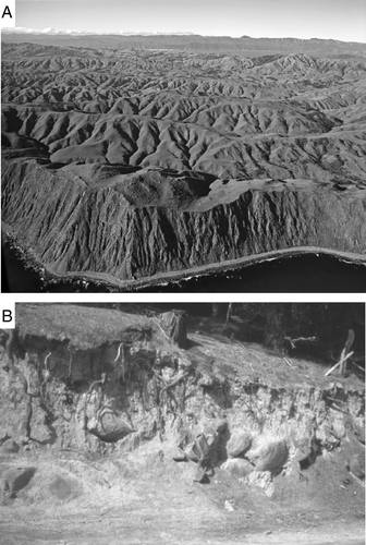
Figure 9 A, Oblique aerial photo looking north-east across the central part of the Wellington Peninsula (Port Nicholson in background) showing flattened hill tops of N–S trending ridges that represent remnants of the peneplain surface (photo: DL Homer, GNS Science). B, Photo showing solifluxion material exposed at Belmont. Such deposits contained the ‘travelled boulders’ described by Crawford in 1869a (photo: R Grapes).
Crawford (Citation1885a) also recorded sparsely distributed water-worn pebbles ‘possibly a foot or yard or more from each other’ within the soil and subsoil developed on Pleistocene sediments preserved on the hills surrounding Miramar Valley that he considered were a ‘very puzzling geological problem, possibly involving great movements of the Earth's surface’. As there was no evidence of marine deposits ‘above a height of about 15 feet [4.6 m] from present high-water mark’, that ‘subsidence of the land to an extent of 1,000 feet [305 m] or more’ was highly unlikely, and no evidence that the pebbles were ‘the remains of a conglomerate, or a coarse sandstone rock, which had undergone decomposition’, he concluded that the water-worn pebbles supported his theory that Port Nicholson had once been a freshwater lake (Crawford Citation1874) (see below).
The Wellington Pleistocene sediments were briefly described by McKay (1879b) (although he incorrectly refers to them as ‘Pliocene’ deposits) as ‘conglomerates followed by a considerable thickness of sandy clays’, from various localities within Wellington City and in Karori (), and commented that the only fossils present were indistinct remains of plants. He considered that they ‘…sometimes closely resemble the Pumice Sands and Rotella beds of the East Coast of the North Island, to which they may with tolerable certainty be referred’, i.e. of Pliocene age. According to Begg and Mazengarb (Citation1996), McKay's ‘conglomerates and sandy clays’ are pre-Last Glacial terrestrial deposits.
Figure 10 Map showing the distribution of Pleistocene-Holocene sediments in the Wellington Peninsula and the Makara Pliocene rocks (after Begg and Johnston Citation2000). The A-B section is after Adkin (Citation1954).
b. Port Nicholson as a freshwater lake
The idea that Port Nicholson has once been a freshwater lake was mooted by Crawford in 1874. He suggested that when the present harbour entrance was closed, a boulder and gravel bar between the mainland and Miramar peninsula dammed a large freshwater lake and that this was the original outlet of the lake. The barrier was sufficiently high so that the lake submerged a large part of the Hutt Valley and the deposits that filled the valley represented ‘talus of the river drifts falling into the lake’. Crawford was not aware of any marine sediments in the Hutt Valley sediments, and characterized the stratigraphy as ‘heavy boulders succeeded by gravels and clay, and finally by fine alluvium, the latter covered by a magnificent forest’. Gently dipping gravels underlying Thorndon Flat at Wellington were also regarded as evidence of deposition in a freshwater lake and borings made in relation to the construction of a wharf there showed the ‘remains of land vegetation at a considerable depth’. The most likely agency for excavation of the lake (harbour) basin, was ice—a glacier with its source ‘neve’ in the Tararua Range that filled the Hutt Valley and flowed south via Evans Bay (). It was this glacier that deposited the boulders (?moraine) that later formed the boulder bank bar enclosing the freshwater lake after retreat of the glacier, and that the boulder bank had subsequently been modified by the sea when the ‘land was depressed some fifteen feet [4.6 m] below its present level’. It was the presence of boulders and gravel on the isthmus between Evans and Lyall Bays [the boulder bank described by Travers (1869)], that raised the question of where such material came from considering that no such sediment was being deposited in more recent time. For glaciation to have occurred, Crawford invoked ‘great elevation’ over a large area, ‘including the whole of Cook Strait to Taranaki and Cape Farewell’ during the Pleistocene (Crawford Citation1874, 1876).
Figure 11 Map showing features relating to the idea of Port Nicholson being a freshwater lake (compiled from information given in Crawford 1874, 1875a,b). Distribution of greywacke and Quaternary sediments after Begg and Johnston Citation2000).
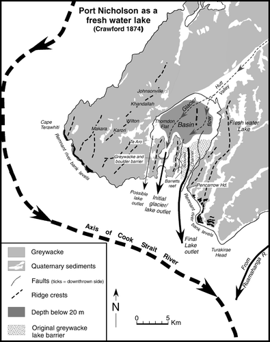
The hypothesis that Wellington Harbour had formerly been a freshwater lake was supported by Hector (in Crawford 1874, p. 378), who considered that the Hutt Valley was ‘a valley of erosion and that there was no evidence that it had ever been occupied by the sea to a much greater extent than at present’. He alluded to ‘drift’ deposited from earlier valley systems that could still be found some 300 m above the sea on the western side of the harbour indicating that ‘the harbour basin had been considerably wider before its present form had been excavated’. Except for ‘the slight rise of the shore-line in very recent times [1855]’, he considered that the most evident change had been marine erosion of the ancient rock barrier across the outlet of the harbour that he believed might have been ‘assisted by inequalities in the movement of the parallel ranges among which the harbour lies’ and which appears to have moved the ‘outlet of the valley to the east’. Crawford thought that from ‘the remains of Barrett Reef and other rocks, it is evident that this entrance or passage has been excavated chiefly by denudation’ in an area where erosion of the coastline had weakened the rocks so that ‘the waters took that direction and scoured out a channel, leaving the old Evans Bay passage high and dry’. At the time of Pleistocene glacial erosion, the present entrance/exit of the harbour/lake had been closed because of the greater elevation of the area.
Implicit in Hector's statement of ‘inequalities of movement of the parallel ranges’ () is the action of faulting, although at that time no faults had been delineated in the Wellington Peninsula. An active fault (the East Harbour Fault) with substantial vertical movement has been proposed as extending through the harbour entrance (Begg & Mazengarb Citation1996), movement on which may have deepened the greywacke basement, possible as a graben developed between the East Harbour Fault to the east and the Seatoun Fault to the west (). Beneath the harbour entrance the greywacke ‘ridge’ is overlain by c. 40 m of sediment (Wood et al. 1989).
The occurrence of ‘water-worn pebbles sparsely embedded in the clay and soil lying over the rock of the hills’ (west of the harbour; ) prompted Crawford (1885a) to suggest that they may have been deposited at some distance from the head of his freshwater lake or indicate ‘where these were gradually distributed by waves or currents over the lake bottom’. The deposits implied, as suggested by Hector, the existence of a lake ‘standing at an elevation of perhaps hundreds of feet over the present sea level’ and ‘show that the boundaries of the lake were far outside those of the present harbour’, and he believed that ‘further investigation will show that deposits of water-worn material, found along the ranges surrounding Port Nicholson, will be more easily accounted for by a theory of lacustrine origin than by bringing in the agency of glaciers’ (Crawford Citation1876, 1885). However, he conceded that further proof of lacustrine deposits might be difficult to obtain and ‘that should such deposits occur in the harbour, they must be overlain by those of marine origin, and could only be found by boring, but there are strata at Karori and Johnsonville, etc., lying on the old rocks [greywacke] [, ], which might be well to study to see whether they are lacustrine or marine. The talus on which that part of Wellington called Thorndon is built might also yield some information, as also the lower parts of Te Aro’ (, 11) (Crawford 1885a).
The deposits on the hills west of the harbour referred to by Crawford are isolated occurrences of variously weathered Quaternary alluvial gravels, some with well-rounded clasts up to 0.5 m diameter, associated with colluvium, loess, silt, sand and peat that overlie greywacke, frequently as channel fill, in the Johnsonville/Khandallah/Wilton/Karori areas (Brodie Citation1957; Begg & Mazengarb Citation1996) (). The deposits are typically < 50 m thick and a minimum age is given by the occurrence of the 350 ka Rangitawa tephra (Te Punga Citation1984).
Captain Frederick Hutton (in Crawford 1874; p. 378–379) pointed out that ‘the pleistocene beds, on which a large part of Wellington was built, were distinctly stratified, and therefore must have been deposited in still water; but as they rose to a height of 150 feet [46 m] above the sea level, and were continued uninterruptedly across to Island Bay, Wellington Harbour had, therefore, geologically speaking, three openings, viz, the present entrance, that between Evans and Lyall Bays, and that from Te Aro to Island Bay []. But no lake can have more than one opening, consequently the pleistocene beds of Thorndon, Te Aro, and the cutting going down to Evans bay, must be either marine, or else they must have been formed in a lake in which Mt. Victoria and Miramar Peninsula stood as islands’. Hutton reasoned that if this was the case, then the lake must have had a much more extensive southern barrier that extended from Cape Terawhiti to Pencarrow Head (), and consequently the lake, if it existed, was much older than suggested and ‘probably not later than the lower eocene’.
The record does not elaborate on Hutton's ‘not later than lower Eocene’ age of the inferred freshwater lake, but the nearest Eocene-Oligocene sediments (quartzite, glauconitic sandstone and minor siltstone) overlying greywacke occur near Paraparaumu some 47 km northeast of Wellington (Macpherson Citation1949), and he may have been referring to these rocks that had been recognized as ‘Tertiary’ by Crawford (1865). Although there is a low-lying corridor between Wellington and Island Bay, the highest point at 26 m above mean sea level, there is no ‘uninterrupted’ extension of Pleistocene sediments along it (, ). Possibly for this reason, Walter Mantell did not consider that there had been a lake outlet through Island Bay. He agreed that the lake had only one outlet, at least at any one time, and considered this to have originally been through Evans Bay (Crawford Citation1874).
The idea of glacial erosion to form Wellington Harbour has been replaced by the action of faulting mainly relating to vertical displacement on the Wellington Fault (down to the southeast) to create a fault-angle depression, coupled with erosion by a paleo-Hutt River (Bell Citation1910; Cotton Citation1912). Bell considered that the Port Nicholson depression began with the formation of a graben ‘somewhat complex in nature’ which extended up the Hutt Valley. He thought that initially the graben was not downfaulted to below sea level and that it was occupied by a paleo-Hutt River that shaped the contours of the depression prior to renewed downward movement of at least the southern part of the graben and invasion by the sea. Bell's ‘complex graben’ was considered to consist of several parallel and transverse fault-bounded blocks with different levels of depression or elevation, and he cited as examples, the ‘lows’ or corridors recognized by Crawford, Hutton and Mantell, between Lyall Bay–Evans Bay and Island Bay–Lambton Harbour, and the ‘highs’ of Seatoun and Kilbirine hills, Somes and Ward Islands ().
Subsequent studies suggest that the Evans Bay–Lyall Bay corridor may have been formed by the paleo-Hutt River exploiting the crush zone of the Evans Bay Fault that strikes N–S across the Kilbirnie isthmus, and then migrating to a more easterly exit though the present harbour mouth facilitated by movement on the East Harbour and possible Seatoun Faults (e.g. Lewis and Mildenhall Citation1985; Begg and Mazengarb Citation1996) ().
c. Marine terraces
Along the Cook Strait coast, Crawford (Citation1869c) records the presence of terraces in the southern part of the North Island at ‘about 1000 [305 m], 400 [122 m], and 250 to 300 feet [76–91 m],’ and that ‘between these principal terraces are many smaller ones. Although fossils are in general absent, it is likely that the terraces mark successive rests in the land during its rise’. He considered that ‘to account for them as lake terraces would require the supposed erection, or rather the demolition of a vast number of barriers’ and regarded the terraces as old beaches. He later suggested that the marine benches preserved between Cape Terawhiti and Tongue Point (Figs.10, 11, 12) were possible remnants of the banks and various levels of his proposed ancient, eastward flowing ‘Cook Strait River’ (Crawford Citation1874). The coastal platforms preserved along the south Wellington coast were also ascribed a marine origin by McKay (1879a), although in his report in the Geological Explorations of 1879b no reference is made to their origin, suggesting editing by Hector. McKay's unpublished views are given below:
We have now to consider the conditions under which the high level terraces on the coastline between Sinclair Head and Cape Terawiti were formed.
To all appearances these constitute a plain of marine denudation 150 [45 m] or 200 feet [61 m] above the sea, or less according to the breadth of the terrace. These terraces are again being cut away at a lower level by the present erosion of the shoreline so that they are bounded to the seaward by high vertical cliffs exposing the fundamental rocks [greywacke] at their base, but in the higher part [are] composed of gravel beds forming the outer part of the surface deposits of these terraces with a moderate slope to the seaward but inland along the buts of the hills the slope is greater and materials at the surface are mostly slope deposits. (McKay Citation1879a)
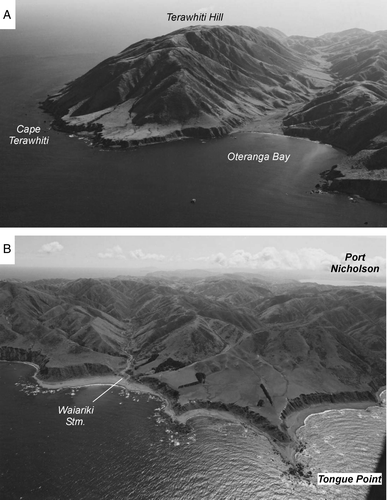
In 1887 and in 1888, James Park having ‘satisfied’ himself that the main coastal terrace (he uses the term ‘rock shelves’) was not an uplifted platform of marine erosion because its height along the coast was highly variable and its surface undulatory, attributed the platform to the work of ‘an ice sheet or glacier flowing through the depression occupied by Cook Strait’. Flat-topped Mana Island off the west coast of Wellington Peninsula () was used to support this origin as was the ‘lion form of contour’ (roche moutonee) of Somes Island in Port Nicholson when viewed from the south, being ‘characteristic of ice erosion in all glaciated areas’ (Park Citation1909). Park's hypothesis was a case of a flawed premise leading to a flawed conclusion and it was Charles Cotton in 1913, apparently unaware of McKay's proposal, who returned to Crawford's original idea, that the elevated coastal platforms such as the most prominent one at Tongue Point (b) had been cut by the sea during ‘pauses in the movement of uplift’.
Figure 12 Coastal terraces preserved along the south coast of Wellington Peninsula, and first postulated by Crawford (1869b) as being of marine erosional origin and later, in 1874, as a possible remnant of a fluvial terrace that bordered a Cook Strait River. A, Terawhiti Hill (photo: CN 6921-1 by DL Homer, GNS Science). B, Tongue Point (photo: CN 21396-3 by DL Homer, GNS Science). See for localities.
McKay (1879a,b) regarded the marine terraces as a Pliocene feature, but as
No marine shells or other fossils indicate the age of these deposits …the conjecture of their Pliocene age must look elsewhere for supporting evidence.
That the greater part of both islands was considerably depressed during the Upper Pliocene Period is shown by the deposits of strata containing marine shells at Wanganui, along the shores of Palliser bay and at numerous places on the East Coast of the South Island as for instance, Motanau and Amuri Bluff hill and the succession between the Wairau and the Conway River and also conspicuous at Kaikoura Peninsula and elsewhere to the north along the coast, shows that this depression was throughout these districts universal. (McKay Citation1879a)
This evidence indicated that as the coastal terraces had been cut across Pliocene rocks it implied that they could be younger and McKay conceded this possibility in his 1879b paper, ‘…as at the upper end of Palliser Bay Pliocene strata are unconformably overlaid by gravels presumably of the same age as those here treated [are] of’—a relationship also noted by Hector (1879) in that the ‘high level gravel terraces capping the Tertiary rocks… must be younger than the coastal terraces’. The ‘coastal terraces’ are now regarded as a Last Interglacial feature (Ota et al. Citation1981; Begg and Mazengarb Citation1996).
Recent sediments, uplifted beaches, human and faunal remains
McKay's 1872 and 1879b classification of Recent deposits (from youngest to oldest) at Wellington comprised:
| 1. | recent deposits at the head of Evans Bay, raised beaches containing marine shells | ||||
| 2. | accumulations by the hand of man—refuse heaps near Maori encampments | ||||
| 3. | brown sands containing moa eggs, shells, bones etc. | ||||
These deposits were mainly described from the Miramar peninsula and Kilbirnie isthmus ().
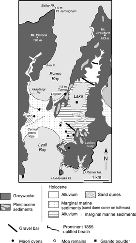
Figure 13 Map showing geology of Miramar peninsula and Kilbirine isthmus. Compiled from various sources; distribution of greywacke and Quaternary sediments (Begg and Mazengarb Citation1996); gravel bars, lake, lagoon, Pa site (Adkin Citation1959, Stevens 1974); uplifted 1855 beach (McKay 1879a; Bell Citation1910; Adkin Citation1955, 1956, 1957); Maori ovens, moa remains, granite boulder (Crawford 1873; McLeod Citation1912). Amount of uplift during the 1855 earthquake is shown for Balley Rock (off Point Jerningham) and the Evans Bay exit of a tunnel excavated through greywacke by Crawford to drain the lake in Miramar Valley.
a. Recent deposits
According to McKay (Citation1879a), ‘the youngest deposits with a radius of 6 miles [3.7 km] from Wellington’ are shell-bearing sands and ‘scarcely above high-water mark’ (McKay 1879b), at the southern end of Evans Bay that ‘had solidified through the decomposition of the calcareous matter into a solid rock now containing numerous casts of recent shells which are very interesting in as much as but for the position evidence of their being so formed and that at a very recent period, they might by their now condition be referred to beds of some considerable age’. These shell-bearing sands are now covered by fill.
b. Uplifted beaches
The ‘deposits next in age’ (the youngest in the Wellington area) are described as’…the result of the earthquake upheaval in 18_’ [McKay seems to have forgotten the date—in 1855!] whereby the southern shore of the harbour was elevated 3 to 5 feet [0.9 to 1.5 m] leaving beds of marine shells in several places to mark the amount of elevation. One of these is to be met with on the sandy flat between the Tea Gardens [at Te Aro in his 1879b report] beyond Powder Point [Magazine Point or Point Jerningham; ] and the present shoreline. Elsewhere where only hard rock was laid bare that fact and amount is still evidenced by the height at which we find the burrows of Pholas and other boring organisms’. Uplift in 1855 of the beach surrounding Lambton Harbour fronting Wellington was recorded by a number of primary and secondary sources as detailed in Grapes and Downes (1997:311–312), and a resurvey of the Wellington foreshore made in September 1856 in connection with land claims consequent on the uplift indicates the seaward shift in the position of the high tide line by about 80 m (Fig. 20 in Grapes and Downes Citation1997). Precise measurement of 1.5 m uplift was made at Balley Rock, off Point Jerningham (Roberts 1855), and of the same amount on the eastern side of Evans Bay as indicated from the change in height of a tunnel with respect to high tide level made by Crawford (1858) (). In his 1855 abridged version of ‘Geology of the Port Nicholson area’, sent to England from Sydney on May 1848, Crawford commented that ‘fluctuations in the height of the land’ caused by earthquakes should be looked for by geologists and that ‘a tunnel which he cut horizontally from high water mark to drain Burnham Water in the Peninsula near Wellington [Miramar], will form a good mark in that locality’, as it proved to be in 1855.
Except for a comment in a letter to Sir Charles Lyell in September 1862 by Haast (1862) that ‘the raised beaches at the entrance of that [Wellington] harbour are most conspicuous’, there appear to be no contemporary reports specific to the prominent 1855 uplifted beach on the south (Cook Strait) coast between Breaker Bay and Lyall Bay (). This was first photographed by Bell in 1910, and described as extending ‘for miles along the wild shore, elevated about 5 ft. [1.5 m] above the present high tide level. In places the surface of the beach bordering the steep marine-denuded cliffs is so flat, and composed of such fine gravel, that it resembles an artificial embankment. Elsewhere occur flats, 5 or 6 chains [100–121 m] wide or even more, surmounted by skerries [small rocky outcrops] which until very recently were washed by the waves’.
An older uplifted beach had been noted by Crawford in 1864b; ‘at Terawiti, Oriental Bay [reported by McKay], and elsewhere around the coast, there is a very marked sea beach, waterworn, and the rocks bored by pholas, at about 15 ft. [4.6 m] above the present high water mark’. Crawford also mentions ‘the latest raised beach is that which marks the rise of the land during the great earthquake of 1855’ with ‘the marks of the well known rise of the land, of from 4 [1.2 m at Wellington] to 9 [2.7 m at Mukamuka in Palliser Bay] feet’, and ‘supposed to have sloped off to nothing at Manawatu’.
Crawford's geological map of 1864a shows a wide raised beach line that obviously incorporates the higher terraces, around the entire Wellington Peninsula (), and appears to be a depiction emphasizing the conspicuous coastal uplift of the peninsula such as occurred in 1855 rather than geological reality. Crawford's beach at 4.6 m is possibly a reference to remnants of the highest Holocene beach. He recognized another at about 3.8 m, and noted the presence of a lower beach ridge from ‘gravel and sand, containing struthiolaria, ostrea, pecten, turritella, etc., at a height of about 10 feet [3 m]’ (Crawford 1864b), and pumice at 2.4 or 3.0 m above high-tide level in Miramar Valley (Crawford 1873). An uplifted beach ridge c. 3.8 m above m.s.l. is recorded along the southern extremity of Miramar peninsula between Palmer Head and Hue-te-taka Point (GL Adkin in Stevens Citation1973), the same stretch of coastline described by Bell (1910) (). At Cape Terawhiti, the uplifted beach is now very difficult to recognize and remnants were reported by Stevens (Citation1973) at c. 2.0 and 1.5 m above m.s.l. but confusion with the modern storm beach is not easy to resolve.
c. Moa remains and evidence of Maori occupation
In the sand-hills at either end of the Kilbirnie isthmus that joins Miramar peninsula to the mainland (), McKay (1879b) attempted to discriminate between deposits containing moa bones which resulted from their being hunted and eaten by the Maori, from those which had been deposited naturally. He records the presence of ‘very considerable accumulations of marine shells and other remains, which are the result of the occupation of this district by the Maoris’, and the general stratigraphy as: An upper, ‘superficial’ part consisting of ‘waste-heaps’ of mollusc shells, fish bones and other marine animals together with ‘numerous remains’ of tuatara (McKay 1879a) and a few bird bones. Underlying sands, the upper part of which is more compacted and contains abundant bones of moa, tuatara (including ‘jaws and other portions of the skull; McKay 1879a), and a large variety of flying birds, together with innumerable fragments of moa egg shells.
The contact between the two layers was normally clear-cut, but in some places the two layers were partially mixed (described as ‘pell-mell’ by McKay 1879a) and at other places the lower horizon was not covered by shell heaps. On the sand-covered hill slopes forming the southwestern part of the Miramar peninsula, McKay found large numbers of moa bones, some of adult birds but most of ‘immature or chick’ birds, and many egg shells exposed in places where the sand had been deflated. He found no evidence of Maori occupation or cooking places in the area and the widespread occurrence of egg shell suggested that the area was probably a moa hatching place. There was no trace of tuatara ‘…or moa remains …discovered on the isthmus although the moas must have been continually crossing and recrossing it, and although perhaps not a favourable spot for the lizards, they were probably not wholly absent’ (McKay 1879a). Moa bones, and a rare skull, had been reported by Crawford (1873), and well as other finds identified and reported by Hector (1872), at Ludlam Gully, Evans, Bay, and in swamp and sand deposits surrounding Burnham Water (). Moa-bone finds continued to be made into the early twentieth century (e.g. McLeod Citation1912).
Evidence of the coexistence of moa and Maori were also indicated from McKay's observations at the site of ‘… and old and extensive Pa [possibly Akautangi Pa; ] occupying the sandhills flanking the range at the west end of the isthmus’ and he also mentions similar occupation sites where moa remains had been found ‘…on Miramar Peninsula [no specific localities mentioned], at the mouth of Happy Valley [Owhiro Bay], and several places along the coast, although nowhere in such quantities as between Evans and Lyall Bays’. Hector (1872) lists a ‘tibia and other fragments of middle size—[that] had been split and cooked (?), Evans Bay’. Subsequently, the question of the time when the moa became extinct became a much-debated question throughout New Zealand. A paper on additional discoveries of moa bones on Miramar peninsula by Henry Christie (Citation1905) drew the comment by the ethnologist Edward Treager that he thought that the bird had been extinct for more than 400 years and that he doubted that ‘Maoris living in or near our own times had ever seen the bird’, whereas Alexander McKay was of the opposite view and instanced places near Wellington where he had collected many moa bones and egg shell and that ‘at one of these spots had found “gallons” of the egg shells, which had plainly been cooked, and the contents of which had doubtless been eaten’. McKay thought that ‘the evidence was overwhelming that the moa was here [Miramar] a hundred years ago’. After some 150 years of moa research, the timing of its extinction is still unresolved (Anderson Citation1989), with ‘…each new find or investigation, in solving some problem, has as frequently revealed new uncertainties’ (Archey Citation1941).
d. Other features
Being the owner of Miramar peninsula, the valley of which he farmed, Crawford had ample opportunity to examine the geology and archaeology and his observations were published in three papers in 1873, and 1885a,Citationb. The hills surrounding the valley consisted of the usual ‘sandstones and slates, standing at an inclination approaching vertical, with a northerly and southerly strike’, and the flat valley ‘containing nearly 700 acres [283 hectares]’ preserved evidence that it had been covered until ‘a late geological period’ by the sea that ‘stood at about fifteen feet [4.6 m] above the present level, as evidenced by water-worn caves, the borings of Pholadae, etc.’ (in his 1885 paper, Crawford refers to ‘a depression of the land to the extent of about fifteen feet [4.6 m]’). Crawford identified three distinct gravel bars or beach ridges across the valley (), and described a stratigraphy of basal gravel, overlain by sand and gravel with numerous marine shells, containing and overlain by abundant pumice together with moa bones (see section b. Uplifted beaches). Above this, extending over a considerable area, was several feet of peat ‘containing roots, stems and branches of trees’. The shells and pumice that were situated ‘at the height of five or six feet [1.5 or 1.8 m] above high water mark’ provided evidence for latest (1855) earthquake uplift of the peninsula.
The central area of the valley was occupied by a large, shallow lake ‘spread over about 200 acres [81 hectares]’, named Te Rotokura by the Maori, and Burnham Water or Para lagoon by European settlers, surrounded by swamp (Crawford 1873) (). On the northern edge of the lake, Crawford measured the thickness of the swamp deposit overlying sand as 1.8–2.1 m, and considered the lake to be a typical example of a ‘wind-formed lake’ (Crawford Citation1880). He reasoned that, ‘if we suppose a flat, composed of sandy soil say, more or less covered by vegetation, and on it a slight depression, which may be caused by the action of the wind blowing the soil away—in this depression storm-water will lodge. This lodgment destroys the grass and other land-plants which may have been growing on the surface; and when the pool had dried by evaporation, the surface of the depression is in a fit state to be again acted upon by wind, any aquatic plants may have sprung up being destroyed by the drying-up of the water. A further deepening and possible enlargement of the pool takes place, and this process goes on until rain again falls and forms a temporary lake. At length the lake may attain sufficient depth to retain its water throughout the year. And then vegetation may spring up round its borders, and a stability of years or of centuries may be attained’.
Evidence of aeolin erosion was also found on the Kilbirnie isthmus in the form of ‘sand-worn stones’ (ventifacts), the initial specimen being described by Travers (Citation1869) as ‘an inch and a half [3.8 cm] in length, pointed at both ends, and presenting three equal triangular faces’. Examining the locality with Hector and Walter Mantell, ‘who were both anxious to solve the apparent mystery’ of their origin, Travers noted that the isthmus consisted of a central ridge consisting of a boulder bank () bordered by sand dunes towards Lyall and Evans Bays; that the boulder bank consisted of sandstone of various sizes and hardness, and that the action of the strong north-easterly and south-westerly winds blowing across the isthmus carried sand ‘by a succession of jumps across the surface’, the cutting action of which had shaped the stones. Travers also noted that the subject of sand-shaped stones had ‘received much attention from geologists and engineers engaged in examining the line of the great Pacific railway’, completed across the United States in 1869, and he was interested ‘to ascertain whether anything of the same kind had been observed by them’.
Rare boulders that appeared ‘to belong to rocks not found in situ’ consisting of ‘a granite (c. 0.3 m long) and a garnet schist (c.13–15 cm long)’ were found on the Kilbirnie isthmus about 4 m above high tide level and ‘several hundred feet’ inland (Crawford 1869), and ‘boulders of granite and schist’ were obtained from the bed of Burnham Water after it had been drained via a tunnel excavated through the greywacke ridge between Miramar Valley and Evans Bay (Crawford 1873), although these could be the same as the earlier recorded occurrence because Crawford's map of the Miramar peninsula shows only the Burnham Water locality (). The compositions of these boulders were recognized as being similar to those at Nelson (presumably the Boulder Bank) and ‘excluding the action of floating ice we must suppose that they were carried either by sea-weed or imbedded in the roots of trees’ (Crawford 1873), rather than having been derived from weathering of conglomeritic horizons within the sandstones and slates. Only one in-situ occurrence of conglomerate within the Wellington greywacke that contains igneous and metamorphic pebbles has been reported from Greta Point, Evans Bay (now covered) (), but the pebbles are only up to 1 cm in size (Lauder Citation1962). In a discussion of Crawford's paper on the Miramar peninsula, where he reported the finds, William Travers (in Crawford 1874; p. 379) considered it more likely that the ‘Nelson’ boulders were ballast from Maori canoes.
Faults
A fault map prepared in 1890 and published in 1892 (McKay Citation1892) shows the Wellington Peninsula transected by three of the ‘Principle faults and earthquake rents’ in New Zealand (). The faults are across-Cook Strait extensions of the Clarence, Awatere and Wairau Faults mapped in the South Island and are numbered 2, 3 and 4, respectively, by McKay. However, in his description of the faults, McKay confuses the fault numbers with their North Island extensions, although he does state that the faults ‘converge and cross each other in the close vicinity of the city [Wellington], and here it is somewhat difficult to distinguish one from the other’. On the 1890 map, the Clarence Fault (2) is shown extending from the south coast near Karori Stream, north-northeast through Wellington along the western side of Port Nicholson, and along the western side of the Hutt Valley, i.e. following what is now known as the Wellington Fault (). McKay's description, incorrectly ascribed to his Fault No. 3 (Awatere Fault), states that ‘it is the line that forms the abrupt western shore of Wellington Harbour between Kaiwara and Petone, and beyond Petone, follows the direction of the Hutt Valley. Beyond this it has not been traced’. According to the 1890 fault map, the Awatere Fault enters the Wellington Peninsula at Oteranga Bay, and trends north-east as a straight line parallel to and almost coincident with the Moonshine–Takapua Road Fault (). Fault No.4 (Wairau Fault) also enters the North Island at Oteranga Bay and follows a more easterly trend to cross the Wellington Fault (= Clarence Fault = fault No.2) near Petone (McKay describes the fault as passing through the ‘City of Wellington’), then across the Hutt Valley (), thence across ‘the Rimutaka Range at the saddle by which the main road from the Hutt Valley reaches Featherston and the Wairarapa Valley’, to the east coast near Castle Point.
Figure 14 Map showing the distribution of faults (thick solid grey lines labeled 2, 3 and 4) in the Wellington Peninsula according to McKay (1892) and Bell (Citation1910) (solid thin black lines). Other named and unnamed faults shown are from Begg and Johnston (Citation2000).
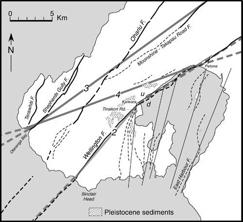
McKay had earlier proposed the existence of a major fault along the western side of Port Nicholson (Wellington Fault);
on the west side of Wellington Harbour the deposits … are at the sea level as inclined strata the basement beds of which dip at considerable angles to the N.E. and East. These beds and the terraces on the coast [e.g. Tongue Point] could therefore only be of the same age by supposing that a line of fault traverses the Eastern [should be western] side of the harbour being there at its greatest down throw and that on the western [should be eastern] side the country south of Kaiwara [Kaiwharawara] to the sea [Cook Strait] and east of the Polhill Gully water parting has been depressed from the level of the beds which we find to occupy the Karori basin to the west which are undoubtedly the same beds as those so largely developed at the Thorndon end of the town [Wellington]. (McKay 1879a)
McKay's description makes sense only if his references to eastern and western are transposed. In other parts of the same manuscript he has actually altered these directions. His reference to the ‘considerable angles’ of dip of the sediments ‘on the west side of Wellington harbour’ probably refers to the angle of slope of stratified congelifractate debris at Thorndon that have been derived from the marine cliff that extended to an appreciably lower sea level (Adkin Citation1954; Stevens Citation1958) (). With the inferred changes in elevation indicated above, McKay's description continues the line of the Wellington Fault to the south coast east of Polhill that equates with two unnamed faults that join with the Happy Valley Fault towards the south and a topographic height difference (), rather than along Tinakori Road. In his 1892 paper describing earthquake faults in New Zealand, McKay extends the Wellington Fault to the coast more or less where it is mapped today, but despite this it was only in Citation1914 that Cotton demonstrated the continuation of the Wellington Fault southwest along Tinakori Road to within about 2 km from the coast.
Figure 15 Map showing distribution of Pleistocene sediments, the Wellington Fault, Happy Valley Fault and associated faults, spot heights and localities (from Begg and Mazengarb Citation1996) to illustrate McKay's (1879a) postulated continuation of the Wellington Fault (thick dashed line) from Kaiwharawara to the south Wellington coast. See text.
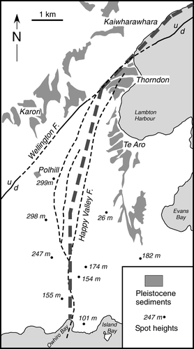
Bell (1910) also commented on the uplifted position of ‘clay terraces, elevated about 300 ft. [91 m] above the present level of the sea, on the steep slopes of the Karori Hills…’ with respect to those preserved at Thorndon, as one ‘proof of the great fault along the western side of Wellington Harbour’ (, ), and considered that the maximum vertical displacement of the fault ‘at the west side of the harbour’ to be not less than 150 m. The clay terraces overhanging Tinakori Road, referred to be Bell as beach deposits on the upthrown side of the Wellington Fault, were regarded by Cotton (Citation1912) as remnants of the floor of a mature valley which was cut across obliquely by the fault. Nevertheless, Bell was the first to recognize the effects of uplift along the fault on drainage across it, such as the lack of grade and formation of waterfalls, the gorged nature and V-shaped valleys of streams.
Earthquakes
Since the founding of Wellington in 1840, several strong earthquakes, a new phenomenon to the mainly British immigrants, were experienced. Sharp shocks were felt in 1840 and 1846 but there were no reports of ground damage (Eiby Citation1968, Citation1973). Only two, in October 1848 and in January 1855, were large enough to cause ground deformation and (in 1855) regional tectonic uplift that were recorded at the time and in recollections of the event (references in Downes and Grapes Citation1999; Grapes et al. Citation2003).
In the M7.4 1848 earthquake, ‘from the Heads [harbour entrance] round to Cape Terawhite large rocks were rent, and fragments rolled down and were precipitated into the sea’ and ‘the shocks were most violent and destructive on alluvial sand, or gravelly formations, as [at] Te Aro and Thorndon flats; on the claystone formation, as on the terraces surrounding the town; and on the Karori-road, at Wades’ town, and Kai-Warra, where the houses are nearer the rock, the shocks were comparatively light. Small clefts were made in the earth at some places, but the water in wells has not been disturbed’ (The New Zealand Evangelist Citation1848). Other contemporary observations of ground disturbance features in Wellington were also noted. ‘Several rents were observed in the ground, chiefly where the soil was gravelly or of a loose character, along the edges of cliffs and terraces; none were of any considerable depth or breadth’ (Fitzherbert Citation1848). Judge Chapman mentions that on 22 October, he observed ‘some earth cracks on the beach near high water mark, and some Pipi shells (or cockles) having been thrown up’ (Westminster Review 1849). Landsliding in the Ngaio Gorge was depicted in a painting by Charles Gold (Citation1849) (Grapes et al. Citation2003).
The most interesting information relates to a fissure that extended along the line of the Wellington Fault suggesting a possible rupture. The New Zealand Spectator and Cook's Strait Guardian of 25 October 1848 refers to a most ‘remarkable’ one (fissure) that crossed the beach ‘on Thorndon Quay a short distance beyond the Cottage of Content’, and a letter written on 9 August ?1910 in response to a lecture given by Bell on Wellington Harbour and the earthquake risk to the brick buildings of Wellington (McDowell undated) refers to the same fissure extending along Tinakori Road and ‘on into the harbour’. Judge Chapman (Citation1849) wrote on 18 November (Postscript) that ‘a report that there had been some subsidence of land at the Wairau Plain … creating a swamp where the land was dry before, and draining a swamp in another place hard by, rests on better evidence, and accords with some slight change of surface on the beach at Wellington—where one side of a slight fissure was left a few inches below the other side, some pi-pi (cockle) shells having been pushed to the surface’.
Similar ground deformation occurred during the M8.3 1855 earthquake which was accompanied by a tsunami and tectonic uplift as evidenced by the stranding of beaches and rock platforms around Wellington Harbour and the Cook Strait coast (see above; Grapes and Downes Citation1997). ‘About Wellington, several fissures occurred, one at the corner of Willis and Manners Streets extended to the harbour where it was necessary to lay planks so that passage way could be obtained; while the deep hole nearby exuding mud... Another fissure occurred beyond Pipitea Point and went up into Tinakori Road, and later disappeared altogether being filled with debris and harbour siltings’ (Taine Citation1855). This last reference also refers to possible rupturing along the line of the Wellington Fault, but it could be a confusion with the same feature apparently observed in 1848. Landslides occurred from the steep hills along the western side of the harbour, the largest of which formed the subject of a sketch by Charles Gold, and in the Hutt Valley there were numerous reports of ground fissuring, landsliding from surrounding hills and sand fountaining due to liquefaction (accounts and landslide sketch are given in Grapes and Downes Citation1997).
Both the 1848 and 1855 earthquakes were attributed to volcanic activity. In 1848 it was initially believed that ‘a volcano had broken out in some of the mountains near the center of the island [North Island]’ (New Zealand Evangelist 1848), an idea strengthened by the appearance of lights flaring across the sky seen to the north-east of Wellington. Chapman (1849) considered that only a very small increase of volcanic action from Tongariro could account for the earthquakes. However, the Wellington Independent of 25 October reported that ‘Tongariro has not burst out, so that we must look to other quarters’, and the night lights proved to be those of the Auroa Australis. For the 1855 earthquake, Haast (1862) conjectured, ‘It is evident, that in Cooks Straits, near the entrance of Wellington harbour a submarine volcano exists and that the earthquakes in Wellington are closely connected with it’. Crawford (1865; 1869b) also noted that ‘…after the earthquake of 1855, dead fish and a bituminous substance, were washed up on the coast near Wellington, shewing that volcanic action in the Strait had been attended with the emission of gases, or lava, or noxious products of some kind’. A volcanic cause for the earthquake was accepted by Hochstetter (1864), who obtained the information from Haast; ‘All observed phenomena point to an epicentre out in Cook Strait, and it is an opinion generally circulated by the colonists that a submarine volcano is situated here, having a connection with these outbreaks of earthquakes. In fact, soundings carried out by English Naval Officers, show that, in front of the entrance of Wellington Harbour in 41°25'S Lat. and 174°37'E Long., a deep crater-like hole is found on the sea bottom, over which the sea restlessly heaves up an down.’ Although there is no submarine volcano, Hochstetter's ‘crater-like hole’ is located within the Cook Strait Canyon (), and the grid coordinates are almost identical with the 41.4°S 174.5°E ± 0.5° epicentre for the earthquake based on felt intensity isoseismals inferred by Grapes and Downes (Citation1997).
Figure 16 Map showing location of the Cook Strait ‘volcanic source’ of the 1855 earthquake inferred by Haast (Citation1862) and Hochstetter (1864).
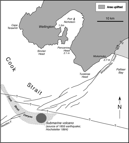
Summary and assessement
Between 1840 and 1892, the naturalist Ernest Dieffenbach, and geologists James Crawford and Alexander McKay in particular, established the foundations of geology of Wellington Peninsula in terms of the main rock type—greywacke, its general, although complicated structure, sparse annelid (i.e. Torlessia mackayi now recognized as the agglutinated foramaniferal family Bathysiphonidae) and plant fossil content, possible stratigraphy and inferred Carboniferous/Permian to Triassic age. Based in Wellington, Crawford and McKay also recorded and commented on many other aspects and peculiarities of the geology, namely, the distribution and nature of Tertiary, Pleistocene and Holocene sediments, origin of coastal terraces (due to marine erosion) and Wellington Harbour (a former freshwater lake), recognition of faults, in particular the Wellington Fault and its sense of vertical displacement (uplift on the northwest side), earthquake-uplifted beaches, the moa and its relation to Maori occupation. McKay's legacy in Wellington Peninsula is recorded in eight papers and two unpublished manuscripts and, apart from some errors and contradictions, is consistent with his almost unassailable reputation and stature as the greatest New Zealand field geologist of the nineteenth century. On the other hand, the reputation and work of Crawford are much less well known. Like McKay, he was a bold thinker and possessed a serious and far-sighted intellect that attempted to explain Wellington geology in terms of ‘the big picture’ of regional uplift and subsidence. He published 17 papers that dealt with the geology of Wellington, mostly within the wider context of the Wellington Province that included the Wairarapa, Manawatu, Rangitikei, Wanganui and central volcanic areas. Bell's 1910 publication on physiography also had regional significance with the delineation of a peneplain surface (also recognized as an important erosional event by Crawford and McKay) subsequently deformed by faulting. His work established a geomorphological framework for the Wellington region that was developed in terms of active tectonics and climate change in the seminal and internationally acclaimed work of Sir Charles Cotton between 1912 and 1972 (Grapes Citation2008). Compared with our current early twenty-first-century understanding of Wellington geology-physiography and the processes that have formed it, the published and previously unpublished archival material used in this study reveals a more substantive record of the development of geological thinking by these first geologists than is currently understood and appreciated by the earth science community.
Acknowledgements
Dallas Mildenhall (GNS) is thanked for information on fossil plant impressions in the Wellington greywacke. Comments from two anonymous reviewers are appreciated.
References
- Adkin , GL . 1954 . Late Pleistocene and Recent faulting in the Otaki-Porirua and Dalefield-Waipoua districts of south Wellington, North Island, New Zealand . Transactions of the Royal Society of New Zealand , 81 : 501 – 519 .
- Adkin GL 1955, 1956, 1957 . Unpublished field notebooks , Institute of Geological and Nuclear Sciences Ltd., Library , Lower Hutt, , New Zealand .
- Adkin , GL . 1959 . The Great Harbour of Tara. Traditional Maori pace-names and sites of Wellington harbour and environs , Wellington and Christchurch, Whitcombe & Tombs .
- Aitchison-Windeler SN 1973 . Gold mining at Cape Terawhiti, Wellington . Victoria University of Wellington, Publication of the Geology Department 3 .
- Anderson A 1989 . Prodigious birds: moas and moa-hunting in prehistoric New Zealand . Cambridge University Press , Cambridge .
- Archey , G . 1941 . The moa. A study of the Dinornithoformes . Auckland Institute Museum Bulletin , 1 : 1 – 145 .
- Barlow JJ 1997 . The geology of the Torlesse terrane, Tongue Point, south Wellington coast, New Zealand . Unpublished BSc (Hons) thesis, School of Earth Sciences, Victoria University of Wellington , Wellington , New Zealand .
- Begg JG , Johnston MR compilers 2000 . Geology of the Wellington area. Institute of Geological and Nuclear Sciences 1:25 000 geological map 10. 1 sheet + 64p . Lower Hutt, New Zealand, Institute of Geological and Nuclear Sciences Limited .
- Begg J , Mazengarb C 1996 . Geology of the Wellington area, scale 1:50 000. Institute of Geological and Nuclear Sciences geological map 22. 1 sheet + 128 p . Lower Hutt, New Zealand, Institute of Geological and Nuclear Sciences Limited .
- Bell , JM . 1910 . The physiography of Wellington Harbour . Transactions of the New Zealand Institute , 42 : 534 – 540 .
- Broadgate , FK . 1916 . The ‘red rocks’ and associated beds of Wellington Peninsula . Transactions of the New Zealand Institute , 48 : 76 – 86 .
- Brodie , JW . 1953 . Stratigraphy and structure of the greywackes and argillites on the south coast of the Wellington Peninsula . New Zealand Journal of Science and Technology , 34 : 205 – 226 .
- Brodie , JW . 1957 . Late Pleistocene beds, Wellington Peninsula . New Zealand Journal of Science and Technology , 38 (B) : 623 – 643 .
- Brodie , JW . 1986 . Terawhiti and the goldfields , 328 Wellington : The Karori Historical Society .
- Campbell HJ , Grapes RH , Simes JE 1993 . Time sliced: the Jurassic corridor in the Torlesse . Geological Society of New Zealand miscellaneous publication 79A, 49 .
- Chapman J 1849 . Article published in the Westminster and Foreign Quarterly Review , April–July, 1849, vol. 51 .
- Christie , HM . 1905 . Recent discoveries of moa-bones on Miramar Peninsula, Wellington . Transactions of the New Zealand Institute , 38 : 585
- Cotton , CA . 1912 . Notes on Wellington physiography . Transactions of the New Zealand Institute , 44 : 245 – 265 .
- Cotton , CA . 1914 . Supplementary notes on Wellington physiography . Transactions of the New Zealand Institute , 46 : 286 – 298 .
- Cotton , CA and Te Punga , MT . 1955 . Solifluxion and periglacially modified landforms at Wellington, New Zealand . Transactions of the Royal Society of New Zealand , 82 : 1001 – 1031 .
- Crawford , JC . 1855 . On the geology of the Port Nicholson district, New Zealand (Abridged) . Quarterly Journal of the Geological Society of London , 11 : 530 – 531 .
- Crawford JC 1861 . Theory for the discovery of gold in the [Wellington] Province . New Zealand Government Gazette (Province of Wellington) 8, 40, Wellington : 269 271 .
- Crawford , JC . 1864a . Geological Sketch Map of the Province of Wellington, New Zealand, and Geological Sections, Province of Wellington, New Zealand , Christchurch : Ward and Reeves .
- Crawford JC 1864b . Geological and other reports . Council Paper, Province of Wellington, Session XI , 17
- Crawford JC 1865a . Essay on the Geology of the North Island of New Zealand . 27 pp. Printed for the New Zealand Exhibition, Dunedin 1865 .
- Crawford JC 1869a . On boulders and travelled blocks in the Wellington Province . Transactions of the New Zealand Institute 1 : 79 80 (also in second edition, 1875, 19–20) .
- Crawford JC 1869b . Essay on the geology of the North Island of New Zealand . Transactions of the New Zealand Institute 1 : 27 (also in second edition 1875, 305–328) .
- Crawford JC 1869c . On indications of changes in the level of the coast line of the southern part of the North Island, as deduced from the occurrence of drift pumice (abstract) . Transactions of the New Zealand Institute 1 : 38 39 ( also in second edition 1875, 442–443 ).
- Crawford , JC . 1870 . On the geology of the Province of Wellington . Transactions of the New Zealand Institute , 2 : 343 – 360 .
- Crawford , JC . 1873 . Notes on Miramar Peninsula, Wellington Harbour . Transactions of the New Zealand Institute , 5 : 396 – 400 .
- Crawford , JC . 1874 . Port Nicholson an ancient fresh-water lake . Transactions of the New Zealand Institute : 290–294 , 6 : 378 – 379 .
- Crawford , JC . 1875a . Did the great Cook Strait river flow to the north-west or to the south-east? . Transactions of the New Zealand Institute , 7 : 448 – 450 .
- Crawford , JC . 1875b . Some further proofs as to the ancient Cook Strait river, and the harbour of Wellington as a fresh-water lake; also a consideration of the date at which the islands were united . Transactions of the New Zealand Institute , 7 : 451 – 453 .
- Crawford , JC . 1876 . On the old lake system of New Zealand, with some observations as to the formation of the Canterbury Plains . Transactions of the New Zealand Institute , 8 : 369 – 375 .
- Crawford , JC . 1877 . On probable reasons why few fossils are found in the Upper Palaeozoic, and possible Triassic rocks of New Zealand . Transactions of the New Zealand Institute , 9 : 561 – 564 .
- Crawford , JC . 1880 . On wind-formed lakes . Transactions of the New Zealand Institute , 12 : 415 – 416 .
- Crawford , JC . 1885a . On water-worn pebbles in the soil . Transactions of the New Zealand Institute , 17 : 341 – 342 .
- Crawford , JC . 1885b . On changes in the Hataitai Valley . Transactions of the New Zealand Institute , 17 : 342 – 343 .
- Crawford JC (undated) . First page of a manuscript (6 pp) entitled ‘Some Observations on the geology of New Zealand’. Crawford Family Papers 1811–1939, MS-Group-0759, Alexander Turnbull Library, National Library of New Zealand .
- Dieffenbach E 1840 . Extract from a ‘Report to the New Zealand Company, respecting the Physical Condition and Natural History of Queen Charlotte's Sound, Cloudy Bay, Tory's Channel, and the surrounding Country. By Ernest Dieffenbach, M.D., the Company's Naturalist The New Zealand Journal ‘Extra’ (Tuesday, 5 May) 6 .
- Dieffenbach E 1841 . Dr Dieffenbach's Report. Report to the Directors of The New Zealand Company respecting the Natural Productions and Present State of New Zealand . The New Zealand Journal No. 31, 27 March .
- Dieffenbach E 1843 . Travels in New Zealand; with contributions to the Geography, Geology, Botany, and Natural History of that Country 1 London , John Murray .
- Downes G , Grapes R 1999 . The 1855 Wairarapa, New Zealand, earthquake – historical data . Institute of Geological and Nuclear Sciences science report 99/16 , 267
- Eiby , GA . 1968 . A descriptive catalogue of New Zealand earthquakes, Part 1-Shocks felt before the end of 1845 . New Zealand Journal of Geology and Geophysics , 11 : 16 – 40 .
- Eiby , GA . 1973 . A descriptive catalogue of New Zealand earthquakes, Part 2-Shocks felt from 1846 to 1854 . New Zealand Journal of Geology and Geophysics , 16 : 857 – 907 .
- Fitzherbert W 1848 . An account of the earthquakes in New Zealand . New South Wales Sporting and Literary Magazine and Racing Calendar. Sydney, Australia: D. Wall, 76 York Street. Abstracted in: report of the Committee appointed to investigate and report upon Seismological Phenomena in Australasia. In: Hector J ed. Report of the Third Meeting of the Australasian Association for the Advancement of Science, Christchurch, New Zealand, March 1891 505 532 .
- George , AD . 1985 . The origin of metavolcanic and associated argillaceous rocks at Island Bay, Wellington, New Zealand . New Zealand Journal of Geology and Geophysics , 28 : 623 – 634 .
- Gold CE 1849 . Watercolour painting annotated ‘Gullies formed by earthquakes, Wellington, New Zealand 1849’. B-103–006 , Alexander Turnbull Library, National Library of New Zealand .
- Grapes RH 2008 . Sir Charles Cotton (1885–1970): international geomorphologist Grapes RH , Oldroyd D A Grigelis History of Geomorphology and Quaternary Geology . Geological Society of London Special Publication 301 : 295 313 .
- Grapes RH , Campbell HJ 1994 . Red Rocks: a Wellington geological excursion . Geological Society of New Zealand guidebook 11 . 32
- Grapes , R and Downes , G . 1997 . The 1855 Wairarapa, New Zealand, earthquake – analysis of historical data . Bulletin of the New Zealand National Society for Earthquake Engineering , 30 : 271 – 368 .
- Grapes , RH , Lamb , SH , Campbell , HJ , Spörli , B and Simes , JE . 1990 . Geology of the red rocks – turbidite association, Wellington Peninsula, New Zealand . New Zealand Journal of Geology and Geophysics , 33 : 377 – 391 .
- Grapes R , Downes G , Goh A 2003 . Historical documents relating to the 1848 Marlborough earthquakes, New Zealand . Institute of Geological and Nuclear Sciences science report 2003/4 . 221
- Haast J von 1862 . Letter from J. Haast to C. Lyell, dated July 3 1862. Micro-MS-Coll-20–1676, Alexander Turnbull Library , National Library of New Zealand .
- Hannah , MJ and Collen , JD . 1995 . An occurrence of the tube fossil Torlessia mackayi Bather 1906 from southwest Wellington, New Zealand . New Zealand Journal of Geology and Geophysics , 38 : 117 – 119 .
- Hannah , MJ and Campbell , HJ . 1996 . Torlessia mackayi and other foraminifera from the Torlesse Terrane, New Zealand . New Zealand Journal of Geology and Geophysics , 39 : 75 – 81 .
- Hector , J . 1869 . On mining in New Zealand . Transactions of the New Zealand Institute , 2 : 361 – 384 .
- Hector , J . 1879 . Progress report. New Zealand Geological Survey . Reports of Geological Explorations during 1878–79 , : 1 – 41 .
- Heaphy , C . 1860 . On the volcanic country of Auckland, New Zealand; with notes on fossils by the Editor . Quarterly Journal of the Geological Society London , 16 : 242 – 252 .
- Hochstetter F von 1864 . Geology of New Zealand. Contributions to the geology of the Provinces of Auckland and Nelson . Translated from the German and edited by CA Fleming, 1959. Wellington, New Zealand, Government Printer .
- Lauder , WR . 1962 . Notes on the greywacke near Wellington City . New Zealand Journal of Geology and Geophysics , 5 : 626 – 629 .
- Lewis , KB and Mildenhall , DC . 1985 . The Late Quaternary seismic, sedimentary and palynological stratigraphy beneath Evans Bay, Wellington Harbour . New Zealand Journal of Geology and Geophysics , 28 : 129 – 152 .
- Lewis , KB , Carter , L and Davey , FJ . 1994 . The opening of Cook Strait: interglacial tidal scour and aligning basins at a subduction to transform plate edge . Marine Geology , 116 : 293 – 312 .
- McDowell J c. 1910–11 . Letter dated August 19 to Editor of the Evening Post, Wellington . Family scrapbook of Alistair Stuart of Gladstone, Wairarapa. Wairarapa Archives , Masterton , New Zealand .
- McKay A. 1872 . Unpublished manuscript dated August 1872. MU 000135/10, Box 3, 1p. Archives, National Museum of New Zealand .
- McKay , A . 1877 . Report on the Tertiary rocks at Makara . New Zealand Geological Survey Report of Geological Explorations 1874–6 , 9 : 54
- McKay A 1879a . Unpublished report on the geology of Wellington dated 30 May 1879 . MU 000135/10, Box 3, 20p. Archives, National Museum of New Zealand .
- McKay , A . 1879b . The geology of the neighbourhood of Wellington. New Zealand Geological Survey . Report of Geological Explorations 1878–9 , 12 : 131 – 135 .
- McKay , A . 1884 . On the gold mines at Terawhiti . New Zealand Geological Survey Report of Geological Explorations 1883–4 , 16 : 135 – 140 .
- McKay , A . 1888a . On mineral deposits in the Tararua and Ruahine mountains . New Zealand Geological Survey Report of Geological Explorations 1887–8 , 19 : 1 – 6 .
- McKay , A . 1888b . On the Tauheranikau and Waiohine Valleys, Tararua Range . New Zealand Geological Survey Report of Geological Explorations 1887–8 , 19 : 58 – 67 .
- McKay , A . 1889 . On the limestones and other rocks of the Rimutaka and Tararua Mountains [Abstract] . Transactions of the New Zealand Institute , 21 : 486 – 487 .
- McKay A 1892 . On the geology of Marlborough and south-east Nelson . Part II. New Zealand Geological Survey Report of Geological Explorations 1890–1 , 21 : 35 38 .
- McKay , A . 1894 . On a reported discovery of copper-ore at Karori, near Wellington . New Zealand Geological Survey Report of Geological Explorations 1892–3 , 22 : 91 – 92 .
- McLeod , HN . 1912 . Pre-Pakeha occupation of Wellington District . The Journal of the Earth Settlers and Historical Association of Wellington , 1 : 114 – 118 .
- Macpherson , EO . 1949 . The Otaihanga faulted outlier and notes on the greensand deposits . New Zealand Journal of Science and Technology , B30 : 70 – 83 .
- Mortimer , N , McIntyre , H and Harris , D . 1993 . Terawhiti schist . Geological Society of New Zealand Miscellaneous Publication , 79B : 45 – 63 .
- New Zealand Evangelist 1848 . The Earthquakes . 1, No. V, November 5, 1848 116 .
- Nicholson HH 2003 . The New Zealand greywackes: a study of associated geological concepts . Unpublished PhD thesis, University of Auckland .
- Ota Y , Williams DN , Berryman KR 1981 . Parts sheets Q27, R27 and R28 – Wellington . 1st edition. Department of Scientific and Industrial Research, Wellington. Wellington Late Quaternary tectonic map of New Zealand, scale 1:50 000 .
- Park , J . 1909 . Some evidences of glaciations on the shores of Cooks Strait and Golden Bay . Transactions of the New Zealand Institute , 42 : 585 – 588 .
- Reed , JJ . 1957 . Petrology of the lower Mesozoic rocks of the Wellington district . New Zealand Geological Survey bulletin , 57 : 60
- Steinmann , G . 1905 . Geologische Beobachtungen in den Alpen, II. Die Schardtsche Ueberfaltungstheorie und die geologische Bedeutung der Tiefseeabsätze und der ophiolithischen Massengesteine . Berichte der Natforschenden Gesellschaft zu Freiburg im Breisgau , 16 : 18 – 67 .
- Stevens , GR . 1957 . Solifluxion phenomenon in the Lower Hutt area . New Zealand Journal of Science and Technology , B38 : 279 – 296 .
- Stevens , GR . 1958 . The Wellington Fault . Transactions of the Royal Society of New Zealand , 85 : 633 – 646 .
- Stevens , GR . 1973 . Late Holocene marine features adjacent to Port Nicholson, Wellington, New Zealand . New Zealand Journal of Geology and Geophysics , 16 : 455 – 484 .
- Suneson , NH . 1993 . The geology of the Torlesse Complex along the Wellington area coast, North Island, New Zealand . New Zealand Journal of Geology and Geophysics , 36 : 369 – 384 .
- Taine , JJ . 1855 . Diary , Napier : Original in possession of GJ Taine .
- Te Punga , M . 1953 . The Paryphantide and a Cook Strait land bridge . New Zealand Journal of Science and Technology , 35 : 51 – 63 .
- Te Punga M 1984 . Age, distribution and clay mineralogy of the Mangaroa Ash, Wellington . New Zealand Geological Survey Report G87 .
- Travers , WTL . 1869 . On the sand-worn stones of Evans’ Bay . Transactions of the New Zealand Institute , 2 : 247 – 248 .
- Webby , BD . 1959 . Sedimentation of the alternating greywacke and argillite strata in the Porirua District . New Zealand Journal of Geology and Geophysics , 2 : 461 – 478 .
- Webby , BD . 1967 . Tube fossils from the Triassic of south-west Wellington, N.Z . Transactions of the Royal Society of New Zealand , 5 : 181 – 191 .
- Wellman , HW . 1949 . Pillow lava at Red Rock Point, Wellington . Transactions of the Royal Society of New Zealand , 77 : 306 – 312 .
- Werner AG 1786 . Kurze Klassification und Beschreibung der verschiedenen Gebirgsarten . Waltherischen hofbuchhandlung , Dresden .