Abstract
A prominent feature of New Zealand biogeography is that species endemicity and diversity is not evenly distributed but shows an alternating pattern of latitudinal variation. Endemicity is generally highest in South Island and northern North Island and low in southern North Island. A prominent landscape feature that is partly correlated with this is Cook Strait, which separates the two main islands of New Zealand and marks the southern boundary of a region that interests biogeographers and geologists alike. This region encompasses a zone of intense tectonic strain related to the transfer of plate convergence via subduction into oblique-slip and strike-slip faulting. We review geological information and provide new palaeogeographic reconstructions of the area that depict changes in the distribution of mountains, the extent to which southern North Island was under the ocean, and the history of marine straits over the last 4 million years. This information is essential for the development of testable biogeographic hypotheses. We find that the Wellington region was formerly connected to the relatively mountainous Marlborough area, and more distant than today from the northern island of the time. Significant topography in the Kaimanawa Range is probably of Early Pliocene age. However, the Ruahine-Tararua ranges and Taranaki-Taupo volcanics have formed since c. 1 Ma. The implications for the biogeography of central New Zealand are considerable in terms of habitat availability for establishment of terrestrial species and opportunities for range shifting of both terrestrial and coastal organisms.
Introduction
Biogeography is the study of the distribution of living things (Wallace Citation1876). It has an obvious spatial component, but also a temporal element, as current distributions are the product of past evolutionary process; range changes, speciation and extinction. Approaches used by biogeographers to describe and interpret distribution include taxon inventory, distribution mapping, ecological inference and modelling, and latterly phylogenetic and phylogeographic analyses of molecular data. However, as the primary objective is to understand how biotas (assemblages of plants and animals) have come to occupy space, it is necessary that biogeographers have accurate information about the history and development of habitable space.
The New Zealand archipelago has long drawn the attention of biogeographers owing to its combination of relatively large size, supposed isolation, potential antiquity and distinctive biota (see Goldberg et al. Citation2008). In particular, events associated with the tectonic breakup of Gondwana, which preceded formation of New Zealand, have often been emphasized as central to understanding its biogeography (but see Campbell & Hutching Citation2007; Trewick et al. Citation2007; Landis et al. Citation2008). However, tectonism is by no means restricted in importance to the early history of the New Zealand region, rather its major influence with respect to the size, shape and topography of modern New Zealand began near the start of the Miocene (c. 23 Ma), and thus underpins the geographic context of local evolution. Since that time, New Zealand's form has continued to be modified, not least in the last 4 million years (Myr).
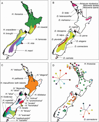
Today, New Zealand consists of two main islands, and one of its more readily apparent landscape features is Cook Strait, a seaway c. 25 km across at its narrowest point that separates these (). In addition to being a highly visible habitat discontinuity, Cook Strait marks the southern boundary of a biogeographic region of comparatively low plant endemicity that extends north to Taupo. There are many instances of disjunct plant distributions across this region that also imply some past or present biogeographic limitation (Wardle Citation1963, Citation1988, Citation1991; Burrows Citation1965; McGlone Citation1985; Craw Citation1989; Rogers Citation1989; Connor Citation2002; Gibbs Citation2006; see also McGlone et al. Citation2001; Wallis & Trewick Citation2009) (). Equivalent patterns of diversity and endemicity are less obviously concordant among terrestrial animals, but some taxa do have range limits associated with the Cook Strait (e.g. separate Petroica robins either side in the North and South islands, a mayfly Acanthophlebia cruenata and a skink Cyclodina aerea range from Cook Strait throughout North Island but not in South Island, the giant weta Deinacrida connectens throughout mountains of South Island to Marlborough but not in North Island). Furthermore, although a generalized boundary of plant species endemism occurs at Cook Strait, it is notable that many plant taxa with predominantly South Island distributions have ranges that extend across Cook Strait to the southern tip of North Island (Wellington region) but no further (Rogers Citation1989). Cook Strait, therefore, appears to be coincident with past biogeographic process(es). At a larger, New Zealand-wide scale, spatial diversity within many speciose animal groups does reveal a trend. For example, among the comparatively well-studied flightless crickets known as weta (Anostostomatidae), both diversity and endemicity are highest in South Island (). There are also some endemics in northern North Island but much of North Island and in particular the central/southern portion, is occupied by few, widespread species, and a few species have ranges that span Cook Strait.
Figure 1 New Zealand at present day (left) and reconstruction for 3 Ma (right). The inferred land area (grey) is shown relative to the modern coastline. Areas of land higher than c. 1000 m are shown in white, areas of low-lying land and marginal-marine deposition in the 3 Ma map are shown in lighter grey. Of note is the large area of modern North Island that has emerged since 3 Ma. Areas of high and low plant endemism in New Zealand are bounded by dashed lines (after Wardle Citation1991), and the southern margin of the north North Island region of higher endemicity is sometimes referred to as the Taupo Line (T). Dotted line indicates the northern margin of plant species that have ranges otherwise restricted to South Island but extend north of Cook Strait (after Rogers Citation1989). Solid black lines in South Island indicate the position of the modern plate boundary along the Alpine Fault and the Marlborough Fault System. Solid black lines in North Island are some of the main faults of the North Island fault system. The Hikurangi subduction trough is shown by the toothed line. The 3 Ma palaeogeographic map has been compiled from several sources, including Beu et al. (Citation1980), Nathan et al. (Citation1986), Field et al. (Citation1989), Turnbull et al. (Citation1993), Isaac et al. (Citation1994), Beu (Citation1995), Bland et al. (Citation2008) and references therein. Abbreviations are: TVZ, Taupo Volcanic Zone; MF, Mohaka Fault; RF, Ruahine Fault; WE, Wellington Fault; MS, Marlborough Sounds; CS, Cook Strait; TG, Mount Tongariro; NG, Mount Ngauruhoe; HH, Mount Hauhungatahi; RU, Mount Ruapehu; WF, Wairau Fault; SK, Seaward Kaikoura Range; IK, Inland Kaikoura Range; CVZ, Coromandel Volcanic Zone; MD, Moutere Depression.
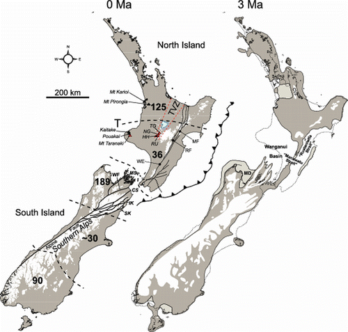
Figure 2 New Zealand biogeography—the weta exemplar. In keeping with observations of the distribution of plant endemicity, the distribution of diversity in many New Zealand taxa has a South Island bias. For example, in the family of crickets called weta (Anostostomatidae), species diversity in the three main genera Hemideina (A), Deinacrida (B), Hemiandrus (C), is highest in South Island; a distinct group of ‘tusked weta’ occur only in the northern parts of North Island (B, Anisoura, Motuweta); wide species ranges in some Hemiandrus and Hemideina extend through North Island. Only two species have distributions that bridge Cook Strait (Hemideina crassidens, A; Hemiandrus maculifrons, C). In one of these, Hemideina crassidens, low genetic distances in phylogeographic data suggest recent exchange between islands. In contrast, high genetic diversity exists among populations of the widespread species Hemideina thoracica (D) and Deinacrida connectens (D), in northern North Island and South Island, respectively. Data from Johns (Citation2001), Trewick et al. (Citation2000), Morgan-Richards et al. (Citation2001), Trewick and Morgan-Richards (Citation2005, Citation2009), Goldberg et al. (Citation2008) and Pratt et al. (Citation2008).
A recent review of New Zealand phylogeography (the study of the geographic distribution of genealogical lineages) did not reveal any single consistent pattern in the distribution of species-level phylogenetic diversity among geographic areas (Wallis & Trewick Citation2009). This is perhaps not surprising given the wide range of ecological attributes expressed by the organisms studied, and a similar lack of congruence has been identified in other parts of the globe, albeit at a larger geographic scale (e.g. Hewitt Citation1996; Taberlet et al. Citation1998). Very probably there are, as yet, insufficient examples of New Zealand taxa with similar ecologies to allow confident conclusions about congruence, or lack of it. It is also likely that, by their nature, phylogeographic studies provide a different level of resolution than given by interspecific comparisons (e.g. inventories of endemicity) because the former usually deal with intraspecific diversity. Several observations from phylogeography do, however, appear to be consistent with the biogeography inferred from endemicity (e.g. Fleming Citation1962, Citation1975; McGlone Citation1985, Rogers Citation1989, McGlone et al. Citation2001 and references therein); a number of plants and animals have subspecific division across Cook Strait with associated genetic differences; phylogeographic divisions exist in some marine taxa in the same region; interior placement of southern North Island lineages in phylogenies imply relatively recent origin of these; several taxa show patterns indicative of southward spread of diversity from northern North Island; many taxa contain relatively low genetic diversity in central and southern North Island (Wallis & Trewick Citation2009). Such patterns in individual studies are variously attributed to Quaternary climate change, volcanic eruptions, and marine inundation, but in most instances there are, in reality, insufficient data to distinguish between these explanations (see Wallis & Trewick Citation2009 and references therein). The resolution and hypothesis-testing power of phylogeographic studies will in future be increased by the use of more stringent sampling design, multigene data and statistical phylogeographic methods (Crisp et al. Citation2010). However, the development of testable hypotheses about the correlation between geological/geographic processes and biological patterns requires more detailed and better time-constrained palaeogeographic reconstructions that provide information about past habitat availability. Rewarding research will come from the integration of phylogeographic and palaeogeographic studies of the most geologically dynamic regions.
Geological context
Central New Zealand, extending across Cook Strait from Taupo to Nelson-Marlborough, is one such region. It has undergone immense topographic and geographic changes during the Plio-Pleistocene (, ), which is a direct result of the region's position within the modern plate boundary zone. (A New Zealand geological timescale is available in Cooper (Citation2004) http://www.gns.cri.nz/Home/Our-Science/Environment-Climate/Paleontology/Online-Resources/New-Zealand-s-Geological-Timescale). The area straddles the modern distribution of ‘North’ and ‘South’ islands, and includes the zone where oceanic Pacific Plate subduction beneath the continental Australian Plate (Hikurangi trough) transitions into continent-continent collision between the two plates (Alpine Fault). Through central South Island the majority of motion along the plate boundary has been accommodated by strike-slip and oblique-slip faulting, with about 480 km of horizontal and 25 km of vertical displacement along the Alpine Fault, yielding the Southern Alps and associated mountain ranges (Kamp Citation1986; Cox & Sutherland Citation2007; ). The tectonic situation in North Island is very different, with the Pacific Plate subducting beneath the Australian Plate, resulting in the rapidly uplifting accretionary wedge (sedimentary material scraped off a subducting plate and accumulated on a non-subducting plate) and arc volcanism (). As most convergence between the plates beneath North Island is accommodated on the subduction thrust (Nicol et al. Citation2007), only a relatively small proportion of the Pacific Plate motion is transferred to the overlying Australian Plate. The result is that mountain building and faulting is and has been less dramatic in North Island than South Island. Furthermore, while North Island is entirely on the Australian Plate with an offshore subduction zone to the east (Hikurangi trough; ), modern South Island is situated on both the Pacific and Australian plates. Parts of northeastern South Island have been progressively captured by the Australian Plate due to eastward fault migration (e.g. Kamp & Furlong Citation2006).
Figure 3 Last Glacial Maximum (c. 14–30 cal ka) reconstruction for New Zealand including locations of some places named in the text. The base map is adapted from Alloway et al. (Citation2007). This map illustrates that the land area of New Zealand was notably different to that which exists today as recently as c. 20 ka ago. This demonstrates how relative sea-level changes as well as the effects of tectonism have had profound influences on the shape of New Zealand and the distribution of its landforms. Abbreviations are: KA, Kaimai Range; KM, Kaimanawa Mountains; AH, Ahimanawa Range; KW, Kaweka Range; RR, Ruahine Range; TR, Tararua Range.
In this paper, we consider the palaeogeography of central New Zealand that encompasses the modern dislocation between ‘North’ and ‘South’ islands and comprises the largest expanse of land emerged from the ocean in recent geological time. Examination of rocks from this area, both in outcrop and subsurface, clearly illustrates that the landforms currently referred to as ‘North Island’ and ‘South Island’ are geologically young, having only acquired most of their shape in the last half-million years or so. This central New Zealand zone has been subjected to phases of rapid subsidence and sedimentary basin formation, followed by periods of rapid uplift, erosion and mountain building. In addition, active arc volcanism and the products of these volcanoes have periodically affected large areas through the deposition of extensive ignimbrite sheets and ash fall (Wilson et al. Citation1995a; Shane et al. Citation1996b; Naish et al. Citation1998; Alloway et al. Citation2005b; Pillans et al. Citation2005). We provide an up-to-date review of the geological literature in order to develop a palaeogeographic synthesis, tracking the development of land and the timing and extent of disjunction between islands past and present, which will provide a robust basis for the development and testing of biogeographic hypotheses.
Palaeogeographic reconstruction
Approach
New palaeogeographic maps have been compiled using a combination of historical and recent information from outcrop mapping, drillholes, seismic interpretation and micro- and macrofossil analysis. The maps therefore summarize the current state of knowledge developed since the pivotal importance of plate tectonics in the development of central New Zealand's landscape was recognized (e.g. Walcott Citation1978, Citation1987; van der Lingen & Pettinga Citation1980; Pettinga Citation1982; Kamp Citation1986; Ballance Citation1993; Lewis & Pettinga Citation1993). While some of the details may change with the addition of new data, the general first-order palaeogeography and timing of tectonic events are not likely to change significantly.
Previous palaeogeographic maps of central New Zealand for the late Neogene (c. last 5 Ma) have invoked extensive strike-slip faulting, contraction and block rotation in North Island on the basis of previously published tectonic reconstruction models of the New Zealand micro-continent (e.g. Wellman Citation1985; Kamp Citation1986; Lewis et al. Citation1994; Beu Citation1995; King Citation2000; Bunce et al. Citation2009). For many years it was assumed that large-scale strike-slip faulting (several hundred kilometres) and tectonic rotations of similar magnitude to those inferred for South Island also occurred in North Island (e.g. Wellman Citation1985; Cutten Citation1991, Citation1994). However, more recent studies have demonstrated that there is little geological evidence for large-scale (>20 km) strike-slip displacement in North Island during the late Neogene, and that extensive strike-slip faulting and tectonic rotation (60°–90°) is not required to reconstruct the tectonic framework of central New Zealand (e.g. Beanland et al. Citation1998; Wallace et al. Citation2004; Nicol et al. Citation2007). Clockwise rotations of c. 45°–50° take up much of the margin-parallel (i.e. parallel to plate boundary) motion at the plate boundary, and most of the margin-normal (i.e. at right angles to plate boundary) contraction (>80%) is occurring on the subduction thrust (Nicol et al. Citation2007). Thus, models including large-magnitude strike-slip offset in central New Zealand are inconsistent with current knowledge.
The palaeogeographic maps presented are drawn relative to the modern New Zealand coastline, and we have made no attempt to deform the coastline to accommodate possible tectonic block rotations, contraction, extension and strike-slip faulting. We acknowledge that such tectonic deformation will have had some influence on the geometry of the study area, but suggest that the amount of deformation is probably small compared to the uncertainties in the palaeogeographic maps. Movement on the large strike-slip faults in central New Zealand (e.g. Wellington, Wairau and Awatere faults) and clockwise vertical axis rotations of the eastern North Island are the most likely source of map distortion due to deformation, but >50 km of strike-slip would be required to significantly distort the palaeogeographic maps and there is little evidence for this (Nicol et al. Citation2007). Of the main strike-slip faults, the Wellington Fault has accommodated <10 km strike-slip (Begg & Mazengarb Citation1996), while rates of horizontal displacement on the Wairau and Awatere faults are currently 4–5 mm/yr (Van Dissen & Yeats Citation1991). If, as it appears, these rates have remained approximately constant since c. 4 Ma on the Awatere Fault (Little & Jones Citation1998) and Wairau Fault (Van Dissen & Yeats Citation1991; Rattenbury et al. Citation2006), their total horizontal displacements would be no more than 20 km. Similarly, clockwise vertical-axis rotations of c. 3°/Ma appear to have resulted in the east coast in the southern North Island moving 10 to 15 km closer to Mount Taranaki over the last c. 5 Ma (Nicol et al. Citation2007). This movement was primarily accommodated by shortening, which was distributed across the entire island and would probably result in only minor distortion of the palaeogeographic maps.
Four million years ago
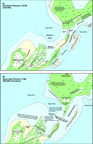
By the Early Pliocene much of the northern North and South islands were exposed as land, although there was significant variation in topography. The Southern Alps were mostly formed by this time, and their elevation has probably changed little since due to a balance being reached between uplift and erosion rates (Koons Citation1989, Citation1995; Cox & Sutherland Citation2007). Sediments produced through erosion of the Southern Alps built large alluvial plains which, in Canterbury, eventually joined South Island to offshore Late Miocene volcanic islands to form what is today Banks Peninsula. Most of southern North Island was still under water (A). In particular, the Wanganui-Manawatu area lay in relatively deep water (c. 200–600 m) due to a period of rapid subsidence and basin formation (named the ‘Tangahoe Pulldown’) that commenced at c. 4.8 Ma (Kamp et al. Citation2004). The main effect of this subsidence was the formation of the Wanganui Basin, and a dramatic increase in water depth from c. 50–100 m to over 600 m in some areas (Hayton Citation1998; Kamp et al. Citation2004). This subsidence was also responsible for the re-opening of a shallow marine seaway (c. 50–100 m deep) and associated deposition across the modern Kaweka Range in the early to mid Pliocene (informally named ‘Kuripapango Strait’; Browne Citation2004a, b; Bland et al. Citation2008). The Kaimanawa Mountains area was land by this time, and both basement and Cenozoic cover rocks were eroding from it to be redeposited in adjacent sedimentary basins.
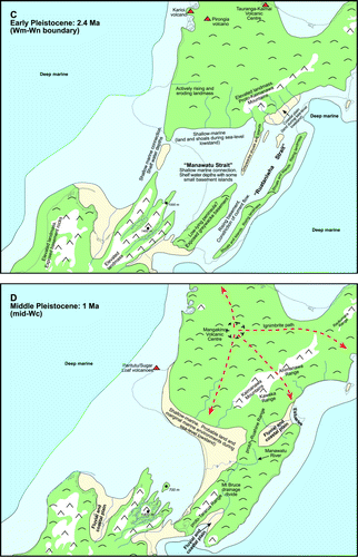
Figure 4 Simplified palaeogeographic maps (4A, 4 Ma; 4B, 3 Ma; 4C, 2.4 Ma; 4D, 1 Ma) illustrating inferred land area (green), areas potentially >1000 m (white), coastal land (light yellow), shelfal water depths (0–200 m; light blue) and deep marine environments (>200 m; dark blue), relative to the modern New Zealand coastline. Inverted ‘Vs’ indicate potential mountains, lower symbols indicate hills. Red dashed arrows (D) indicate ignimbrite paths from the Mangakino Volcanic Centre. MK (A) denotes the location of the Makara inlier, and ‘ + ’ shows location of the Young-1 drillhole. KM (A), Kaimanawa Mountains; ‘Kuri. Strait’, Kuripapango Strait; Wp, Waipipian (3.6–3.0 Ma); Wm, Mangapanian; Wn, Nukumaruan (2.4–1.63); Wc, Castlecliffian (1.63–0.34 Ma). These maps have been compiled from many sources, including Beu et al. (Citation1980), Nathan et al. (Citation1986), Isaac et al. (Citation1994), McIntyre (Citation2002), Browne (Citation2004b), Bland et al. (Citation2008), Nicol (in press) and unpublished work-in-progress at GNS Science.
Continued south and east-directed shoreline retrogradation (marine transgression), which had started in the latest Miocene, continued through the Early Pliocene in southwestern ‘North Island’. An east-west orientated shoreline that occurred over the position of central Taranaki in the latest Miocene (Vonk & Kamp Citation2008) had retreated back to near the site of the modern axial ranges due to the ongoing development of the plate boundary. The western Wellington area was at shelf water depths (c. 50–200 m) as indicated by a small inlier of Early Pliocene marine rocks preserved at Makara, near Wellington city (Begg & Mazengarb Citation1996). The orientation of the shoreline in this area is uncertain, but a shore facing west into the Wanganui Basin appears most likely (e.g. Nicol, in press). There is no evidence for an east-west marine connection between ‘North’ and ‘South’ islands farther south, and it is also likely that the Ruahine-Tararua range area was an emergent finger of basement rocks, albeit at low elevation (see also B). This means that there was probably no seaway across the Manawatu Gorge area at this time. Shoals and small islands were beginning to appear in the easternmost parts of Hawke's Bay and northern Wairarapa due to uplift of the western (inboard) edge of the Hikurangi margin's accretionary wedge (Pettinga Citation1980, Citation1982; Beu et al. Citation1980; Beu Citation1995; Bland et al. Citation2008).
Three million years ago
At this time most of the Wanganui area was deep marine and lay under c. 200–400 m of water, and the Manawatu region was mostly at shelfal water depths (0–200 m; B). Shelfal environments also covered much of the Wairarapa-Hawke's Bay area as part of the narrow but laterally extensive ‘Ruataniwha Strait’ (after Beu Citation1995). Continued uplift of the accretionary wedge complex in eastern Hawke's Bay and northern Wairarapa led to the development of an archipelago of small islands and shallow marine shoals, around which carbonate shell banks accumulated (e.g. Kamp et al. Citation1988; Nelson et al. Citation2003; Caron et al. Citation2004).
Uplift of the King Country area was well under way by 3 Ma (Pulford & Stern Citation2004), and most of the northern parts of modern North Island were land by this time (Isaac et al. Citation1994). Modern topography in the King Country area rarely exceeds 400–500 m due to natural slope and hillside instability. This instability is a consequence of the poorly lithified and thus easily erodable nature of most of the Neogene surface strata, except in areas where harder basement or limestone are exposed. It is therefore likely that maximum topography in the King Country area in the Late Pliocene differed little from that of today. The onset of uplift in the King Country records the motif of rapid subsidence followed by uplift that has occurred along the western margin of North Island throughout the Neogene (see ; Kamp et al. Citation2002, Citation2004; Pulford & Stern Citation2004; Kamp & Furlong Citation2006; Furlong & Kamp Citation2009). Andesitic and rhyolitic arc volcanoes were active in the southern Coromandel and Kaimai area (Briggs et al. Citation2005) and would have contributed topography, which may have approached 1000 m in height in places. To the west of the zone of active arc volcanoes, the northern Waikato area comprised a low-lying coastal plain that abutted shallow-marine environments in the Port Waikato and South Auckland areas (Isaac et al. Citation1994; Edbrooke Citation2001, Citation2005).
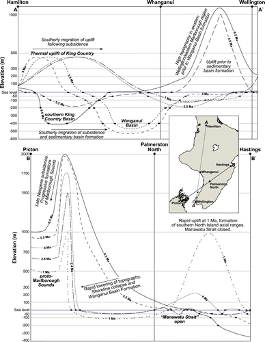
Figure 5 Schematic topographic profiles showing estimated average topography, sea level, bathymetry and thus pattern of elevation change over time. Bathymetry is derived from palaeogeographic maps of southern North Island. The general elevation of the King Country area is based on modern topography and assumed natural hillslope stability. Elevation in the Marlborough Sounds area has been estimated from Nicol (Citationin press). Inset: locations of profiles A-A′ and B-B′.
In the south there was significant topography in the Marlborough area, with large river valleys and mountain ranges of uplifted basement rocks. The height of these mountains, as depicted on B, has been inferred by comparing modern topography in the Marlborough Sounds with now-buried basement relief in this area (Nicol in press). The extent of these mountains was smaller and their elevations lower than that which existed at 4 Ma due to continued subsidence (). Alpine environments may have been existing on these ranges, which were probably part of a large elevated area extending from southern Nelson across to Marlborough. The Wellington area was probably still geographically part of this ‘South Island’ area, although it most likely comprised low-lying basement hills rather than mountainous country. A narrow peninsula of low-lying land probably existed in the region of the modern Tararua Range, and was separated by a narrow seaway (the ‘Manawatu Strait’) in the Manawatu Gorge area from a finger of low-lying land and shallow shoals that extended over the location of the Ruahine Range. The presence of non-marine to marginal-marine greywacke-derived conglomerate beds (including pebbly beach deposits) in Waipipian rocks (3 Ma) west of the Ruahine Range near Taihape indicates that an erodable source of greywacke was present nearby (CitationLee et al. in prep). Also, rocks of Waipipian age were probably not deposited over the axial range area in central and lower North Island (Bland et al. Citation2008), except at Saddle Road, immediately north of the Manawatu Gorge (e.g. McIntyre Citation2002). The inference is that much of the modern axial ranges were at or above sea level at this time. An unconformity between late Waipipian (3 Ma) and Nukumaruan (2.4 Ma) rocks in the Saddle Road section (McIntyre Citation2002) indicates that the Manawatu Gorge area was subject to erosion, and was therefore probably land during the Mangapanian Stage (c. 3.0–2.4 Ma).
Rocks of Opoitian (5.3–3.6 Ma) and Mangapanian (3.0–2.4 Ma) age occur in the Kuripapango region (), whereas rocks of Waipipian age are absent (Browne Citation2004a; Bland et al. Citation2007). This suggests a period of land, non-deposition, and erosion in the Kuripapango area during the Waipipian, an interpretation supported by the presence of significant erosional unconformities of probable Waipipian age (Bland et al. Citation2008).
A large landmass probably existed over the Raukumara Peninsula by this time. Basement rocks were certainly cropping out at the surface in some areas of this landmass, as shown by the presence of greywacke-derived clasts in adjacent sedimentary successions. Areas of exposed basement may have had notable relief, although there are insufficient data to allow accurate estimation of heights. Areas of exposed Cenozoic rocks were present too, and probably formed hilly country. The Wairoa area () still lay at significant water depths, although small islands or shoals may have existed in some areas due to fault-related folding and uplift, as indicated by depositional onlap patterns discernable from seismic profiles (e.g. IRBA Citation1998).
2.4 million years ago
This time marks the position of the Mangapanian-Nukumaruan New Zealand Stage boundary during the Early Quaternary. The Ruahine Range area was under the ocean, probably in the form of a narrow, shallow marine sill. A seaway across the location of the modern southern Ruahine and northern Tararua ranges at shallow shelf depths existed between the eastern Wanganui Basin and central and southern Hawke's Bay area, and separated northern and southern land masses (C). This seaway represents the Manawatu Strait at its most extensive, and to its north was an area of low-lying shoals and islands. Marine deposition onto mostly ravened (sub-aerially eroded and wave-planed) basement in the axial ranges at this time is illustrated by the presence of basal-Nukumaruan shallow marine limestone in many places along the now-uplifted Ruahine and southern Kaweka ranges (Beu et al. Citation1981; Beu Citation1995; Browne Citation2004a; Lee et al. in prep). Erosion of basement from growing ranges to the north of Kuripapango is indicated by widespread deposition of greywacke-derived gravels in western Hawke's Bay in the form of alluvial fans and braided river systems, similar to those present today in Canterbury (Cutten Citation1994; Bland Citation2001; Graafhuis Citation2001; Bland et al. Citation2007, Citation2008). The Wanganui Basin depocentre had moved south and east during the Pliocene (Anderton Citation1981), perhaps in a stepped rather than gradual process, and was located near Whanganui City at this time (Nicol in press). Deposition of sediments from river systems surrounding the eastern margin of the basin was directed into this area.
The Alexandra Volcanics, located in western Waikato, were erupted between 2.74 and 1.6 Ma (Briggs & McDonough Citation1990). Karioi volcano, the north-westernmost of the Alexandra volcanics group (), was active between c. 2.5 and 2.3 Ma (Goles et al. Citation1996). This now deeply eroded mountain would have had many hundreds of metres of relief. The stratovolcano of Mount Pirongia was also formed at this time, and would have had an elevation of over 1000 m at its summit. These volcanic edifices were surrounded by a low-relief coastal plain (Goles et al. Citation1996). The King Country, located south of these volcanoes, continued to rise in response to mantle-driven thermal uplift (Kamp et al. Citation2004; Pulford & Stern Citation2004). This wave of uplift followed a period of subsidence and resulted in erosion (). Elevation in this part of central North Island was probably of the order of several hundred metres due to natural slope instability, preventing the generation of high mountainous topography. The river systems draining this large area of juvenile topography delivered significant volumes of sediment to adjacent sedimentary basins, as is evident from the rapid progradation of the continental shelf in Taranaki-King Country area (e.g. Hansen Citation2003).
By about 1.5 Ma, uplift of the Mount Bruce block in central Wairarapa had closed off the Ruataniwha Strait at its southern end, although marine deposition still occurred in parts of Wairarapa and Hawke's Bay into the late Quaternary (Field et al. Citation1997; Begg & Johnston Citation2000; Lee & Begg Citation2002; , C). The uplift at Mount Bruce indicates a change in displacement along faults in this area. It also initiated a drainage divide east of the proto-axial ranges that resulted in the Manawatu River system developing to the north of the divide and the Ruamahanga River system to the south. Most of the Wanganui-Manawatu area was at shelf to marginal-marine water depths.
Rapid uplift was also occurring farther south in the Nelson-Marlborough area. A large, low-gradient coastal plain was located in the Tasman Bay area due to the large rivers that flowed through the Moutere Depression. These rivers drained adjacent mountain ranges that at this time were rapidly rising and eroding. Substantial rivers still existed in the region of the modern Marlborough Sounds, draining this mountainous area of high topography (>1000 m).
Rhyolitic volcanism in Mangakino Volcanic Centre of the Taupo Volcanic Zone (TVZ; D) had commenced by c. 1.7 Ma, with the focus of arc-related volcanism migrating from the Tauranga-Kaimai centre to the modern TVZ (Carter et al. Citation2003; Briggs et al. Citation2005). This transition was apparently seamless and without obvious breaks or changes in major element composition of volcanic glass. The resulting volcanism from the TVZ since this time has made it arguably the most active and productive rhyolitic system in the world (Wilson et al. Citation1995b; Carter et al. Citation2003; Alloway et al. Citation2005b).
One million years ago
By 1 Ma (D), the Kaimanawa Mountains and Kaweka Range were reasonably well established, and it is likely that some alpine habitat already existed in the northern parts of this area (D). Rapid uplift and formation of the Ruahine and Tararua ranges in their current form commenced at about 1 Ma (Beu et al. Citation1981; Erdman & Kelsey Citation1992; Heerdegen & Shepherd Citation1992; Shane et al. Citation1996b; Lee & Begg Citation2002), although some uplift in this region had probably been initiated by 1.5 Ma (Erdman & Kelsey Citation1992; Lee & Begg Citation2002; Nicol et al. Citation2002; Bland et al. Citation2008). Uplift here was a response to the inception of significant displacement on the Wellington, Wairarapa and Ruahine faults, possibly due to increased convergence across the North Island fault system. The growth of these mountain ranges is indicated in the sedimentary record by the sudden influx of large volumes of coarse-grained greywacke clasts into adjacent basins to the west and east (e.g. Okehu, Mangamaire and Kidnappers groups; Fleming Citation1953; Kingma Citation1971; Kamp Citation1978; Townsend et al. Citation2008; Lee & Begg Citation2002; Lee et al. in prep). Some constraint on the timing of uplift of these ranges prior to c. 1 Ma is provided by the presence of multiple TVZ-derived ignimbrites in Kidnappers Group rocks in Hawke's Bay, which must have been able to flow across the position of the developing mountains (D; e.g. Shane et al. Citation1996a, b). Continued uplift of the Kaweka Range was probably also occurring during this time, and eroded gravels from the range contributed to the alluvial plain developing along the western margin of Hawke's Bay. The King Country and Wairoa areas consisted of extensive hill country, with topographic relief probably similar to that of today.
Much of Hawke's Bay was land by 1 Ma, except for a small area of marginal-marine deposition at Cape Kidnappers (Kingma Citation1971; Kamp Citation1978; Shane et al. Citation1996a). The axial ranges, particularly the Ruahine Range, were rapidly rising, and large volumes of sediment were derived from them (D, ). A braid plain built out from the rising mountains in response to the uplift and erosion, and probably resembled the modern Heretaunga Plains in its general form and character. Uplift in the east of southern Hawke's Bay and northern Wairarapa during the Early Quaternary caused the hitherto east-flowing Manawatu River to drain westwards through the area that would become the modern Manawatu Gorge. Uplift along the western side of the Wellington Fault from 1 Ma in the region of the gorge caused ponding and the formation of a lake (Shane Citation1991; Lee & Begg Citation2002), which was then drained towards the Tasman Sea. Uplift of the Tararua and Ruahine ranges west of the Wellington Fault was not rapid enough to defeat the river, which maintained its westward course to the Tasman Sea, and cut the Manawatu Gorge.
The Wanganui-Manawatu area, into which the proto-Manawatu and other rivers (e.g. Rangitikei, Whanganui) were draining, comprised a combination of low-lying land and marginal marine estuaries as indicated by outcropping strata (Fleming Citation1953; Abbott & Carter Citation1997, Citation1999; Townsend et al. Citation2008). The Wanganui Basin depocentre had moved south, and by 1 Ma lay off the coast of Levin and Foxton (Nicol in press). The proto-Marlborough Sounds at the southern end of the Wanganui Basin continued to be pulled down, and the river valleys in this area became flooded by the Tasman Sea, yielding the flooded valleys or ‘sounds’ seen today. The high hills that surrounded the river valleys of the Marlborough Sounds may have had up to c. 1400 m of topographic relief (Nicol in press). By 1 Ma the Wanganui area had ceased subsiding and began to rise, reflecting the arrival of the uplift part of the sinusoidal wave following subsidence (). The change from subsidence to uplift is marked by the formation of well-developed flights of marine terraces that are preserved in the Wanganui–South Taranaki areas (e.g. Pillans Citation1990a, Citationb; Townsend et al. Citation2008).
Andesitic volcanism in the Taranaki region commenced around 1.7 Ma (Stipp Citation1968; Townsend et al. Citation2008)—the remains of which are Paritutu and the Sugar Loaf Islands in the New Plymouth area. These volcanic centres are the southern part of a southward-developing chain of volcanoes that had lain off western North Island during the Neogene (King & Thrasher Citation1996; Thrasher et al. Citation2002; Giba et al. Citation2010). The Paritutu-Sugar Loaf volcanoes were probably not connected to the proto-North Island, although they most likely formed emergent volcanic islands. Egmont volcano (Mount Taranaki) became active much more recently (by 130 ka, Alloway et al. Citation2005a), although the upper cone is mostly younger than 7000 years old.
Prior to about 2 Ma the TVZ had not formed (Wilson et al. Citation1995b; Carter et al. Citation2003, Citation2004) and the extensive modern plains of the Bay of Plenty area, which are partly the product of crustal rifting and voluminous volcaniclastic deposition, probably did not exist. Marine macrofossils indicate that the Ohope area, near the eastern edge of the modern TVZ, was at shallow marine depths during the Early Quaternary (Beu & Maxwell Citation1990). To the west of the axial ranges, the andesitic stratovolcanoes of the southern TVZ (i.e. Ruapehu, Tongariro) had not yet formed, although volcanic activity was well established by c. 1 Ma in the Mangakino area northwest of present-day Lake Taupo (D; Wilson et al. Citation1995b). A series of large rhyolitic eruptions from the Mangakino volcanic centre resulted in the emplacement of ignimbrites and volcaniclastic deposits over much of central North Island (Wilson et al. Citation1995a).
The oldest volcanic feature in the Tongariro volcanic centre is Mount Hauhungatahi (). Lavas from this mountain have been dated at c. 800 ka (Hackett Citation1985; Cameron et al. Citation2010), and topographic profiles across the mountain suggest that the now-eroded summit vent may have been over 2000 m asl (Hackett Citation1985). The oldest exposed parts of Mount Tongariro, a volcanic complex consisting of several overlapping volcanoes, are c. 275,000 years old (Hobden et al. Citation1996). Mount Ngauruhoe, a cone on the southern flank of the Tongariro volcanic complex, is only c. 2500 years old. The oldest parts of Mount Ruapehu have been dated at 245 ka (Stipp Citation1968; Gamble et al. Citation2003).
By the time of the eruption of the ignimbrites of the silicic Whakamaru group at around 0.34 Ma, the Kaimanawa Mountains and Ahimanawa Range were in much their present form. These mountains created a barrier to emplacement of these ignimbrites, which overlie greywacke in this area (Townsend et al. Citation2009).
The estimated timing of formation of Cook Strait at c. 500 ka (Lewis et al. Citation1994) suggests that the Wellington area was, until this time, still connected to Marlborough via a low-relief land bridge between areas of mountainous topography. This land was likely to have been relatively narrow with sedimentary basins on its northwestern and eastern sides. The developing central ‘New Zealand’ landmasses at 1 Ma may have comprised a single large island with a low, narrow isthmus in the Wellington area (D). After about 500 ka Cook Strait had formed the modern partition between ‘North Island’ and ‘South Island’, although connections between the two islands may have existed during times of low sea level (e.g. glaciations; ).
Discussion
Tectonic activity has been of primary significance for New Zealand since the inception of the present plate boundary. The shape and topography of ‘New Zealand’ since this time has changed markedly as tectonic activity proceeded, from a series of very small islands into the landmasses present today. However, the extent of land area at the start of the Miocene remains somewhat uncertain despite past attempts at reconstructions (e.g. Fleming Citation1975; King et al. Citation1999; King Citation2000), due to the paucity of information on which to form a basis for earliest Miocene palaeogeography (Landis et al. Citation2008). Southern North Island has in particular been subjected to and remains a focus of intense tectonic processes. The inference that tectonic displacement of land areas has had an important role in the distribution of the New Zealand and, in particular, South Island, biota has been largely rejected (McGlone et al. Citation2001; Wallis & Trewick Citation2001; Trewick & Wallis Citation2001). Even so, early inference that tectonic movement of terrestrial surfaces (and biota) might have been important in generating the contrast between southern and northern North Island endemicity (McGlone Citation1985; Rogers Citation1989) was dependent on the assumption of substantial horizontal strike-slip faulting in North Island. Such a view originated from early study of tectonics that inferred that similar amount of strike-slip movement occurred in North Island as in South Island (Suggate et al. Citation1978; Wellman Citation1985; Rogers Citation1989; Cutten Citation1991, Citation1994). Although some continue to ignore modern geological mapping and fault analysis, it is now well recognized that total strike-slip displacement in the North Island fault system in the Plio-Pleistocene has been minimal (<20 km; e.g. Beanland et al. Citation1998; Berryman et al. Citation2002; Bland & Kamp Citation2006; Nicol et al. Citation2007; Bland et al. Citation2008). An important corollary of this is inference of the timing of formation and extent of past seaways in the region. The focus on a single large feature that persists across central North Island throughout much of the Neogene (e.g. Kamp Citation1982, Beu Citation1995; Bunce et al. Citation2009) does not properly accommodate the outcropping geology (Erdman & Kelsey Citation1992; Lee & Begg Citation2002; Bland et al. Citation2004, Citation2007, Citation2008; Browne Citation2004a; Bland Citation2006; Townsend et al. Citation2008; Vonk & Kamp Citation2008; Lee et al. in prep) and drillhole records (e.g. Leslie Citation1971a, Citationb; Johnston & Francis Citation1996; Johnston & Langdale Citation2000) or consider the detailed geological investigations from fault and tectonic analysis (e.g. Cashman et al. Citation1992; Beanland et al. Citation1998; Wallace et al. Citation2004; Nicol et al. Citation2007).
Understanding the palaeogeography and thus biogeography of the region depends on recognition that the tectonic plate boundary between the Australian and Pacific plates operates in very different ways through the New Zealand micro-continent. In particular, large amounts of horizontal movement have occurred in South Island during the Neogene, but much less so in North Island, whereas volcanic activity during the Plio-Pleistocene has been substantial in North Island, but absent in South Island, and arc volcanism is virtually restricted to North Island (except for Solander Island; Turnbull et al. Citation1993). Furthermore, the present-day location of the separation between North and South Islands is in the area where the transition from subduction of Pacific Plate into predominantly strike-slip displacement occurs.
Underlying this is the north-south migration of a wave of uplift, subsidence and sedimentary basin formation, and then basin inversion that has occurred along the western North Island margin through the Neogene (Stern et al. Citation1992; Kamp et al. Citation2004; Pulford & Stern Citation2004; Proust et al. Citation2005; ). The Plio-Pleistocene geological evolution of the western margin of central New Zealand represents one period of this wave. The driving force behind this process is certainly linked in some way to the ongoing development of the plate boundary through New Zealand, although the exact mechanism remains unresolved (e.g. Kamp et al. Citation2004; Pulford & Stern Citation2004; Nicol et al. Citation2007; Stagpoole & Nicol Citation2008; Furlong & Kamp Citation2009). The most recent expression of this ‘wave’ is the formation of land in southern North Island (such as Wanganui), and the separation of modern ‘North’ and ‘South’ islands. Uplift of Wanganui-King Country is the back of the wave, with the drowning of the Marlborough Sounds representing the wave trough. At present the wave front is considered to lie in the Kaikoura-Nelson area.
In the following sections we briefly discuss some of the palaeogeographic issues and features that are illustrated by the maps presented in this paper. These features have implications for biogeography because they provide our best opportunity to estimate the availability and quality of terrestrial habitat in the central New Zealand region during the late Neogene. Biogeographic inference has tended to view New Zealand as a fixed entity and of necessity has applied simplified notions of the influence of Quaternary climate change, tectonic displacement of land surfaces and marine transgression (e.g. Fleming Citation1962, Citation1975; McGlone Citation1985; Rogers Citation1989; McGlone et al. Citation2001 and references therein). Studies that draw on ecological (e.g. habitat preference, dispersal capacity) and population genetic/phylogenetic information have the potential to test alternative hypotheses about the driving forces of taxon distribution, but have been limited by the availability of detailed palaeogeography (see McGlone et al. Citation2001; Wallis & Trewick Citation2009). For instance, the young age of southern North Island coincides with the period of greatest climatic change in the second half of the Pleistocene. It would therefore be useful to know when, where and how much habitat is likely to have existed through this period. Understanding the potential influences of climate change on terrestrial taxa can only really be achieved with inclusion of information about land area and topography over time.
Marine seaways
At least three marine seaways have existed across the trend of axial ranges during the Neogene, including the ‘Manawatu Strait’, the ‘Kuripapango Strait’, and a probable strait in the Lake Waikaremoana area (, ). In general, the age of these seaways appears to decrease towards the south and is consistent with the southward propagation of the plate boundary through time and space, and the southward progression of volcanism, mountain building and increased strike-slip faulting during the past c. 5 Ma. The Manawatu Gorge (and the Late Pliocene ‘Manawatu Strait’) lies very close to where the Wellington Fault bifurcates into the Ruahine and Mohaka faults (Langridge et al. Citation2005). The older Late Miocene–Early Pliocene ‘Kuripapango Strait’ lies near the point where several major faults (the Kaweka, Ruahine and Glenross faults) intersect (Browne Citation2004a; Bland Citation2006). Even older seaways, such as a possible Middle Miocene connection in the Lake Waikaremoana region, also coincide with an area where major faults bifurcate, in this case the Mohaka, Whakatane and Waimana faults. The positions of late Neogene east-west seaways across the modern axial ranges may have been linked in some way to structural dynamics and the transition of displacement from one structure onto another in these zones of fault interactions. Cook Strait, the modern-day marine connection from east-west across the trend of the axial ranges, lies near the southern termination of subduction along the Hikurangi margin, where plate boundary convergence transfers onto oblique-slip the Marlborough fault system and on to the Alpine Fault ().
The oldest cover rocks overlying basement in the area about the Manawatu Gorge are coarse-grained limestone of latest Miocene (late Kapitean, c. 6.5–5.3 Ma) age, and Early Pliocene mudstone (c. 5.3 Ma; Lillie Citation1953; Beu Citation1995; Lee et al. in prep). These rocks crop out to the east of the axial ranges. To the west of the ranges, however, the stratigraphic record contained in the Young-1 drillhole, together with seismic correlations, shows that marine transgression over basement near the gorge did not occur until the Late Pliocene (Waipipian, c. 3.6 Ma; Superior Oil Co. of NZ Ltd Citation1942; Uruski Citation1998; Townsend et al. Citation2008). The apparent absence of any cover rocks older than Late Pliocene (Waipipian) across the axial ranges in the Manawatu Gorge area is consistent with the presence of land between Hawke's Bay and Manawatu during the Late Miocene and Early Pliocene (A, B). This is also supported by the absence of strata older than Late Pliocene in the subsurface of Wanganui Basin west of the gorge (Uruski Citation1998). Coarse-grained Late Pliocene (Waipipian) rocks on the southern end of the Ruahine Range provide the first evidence of a marine breach across the gorge area, consistent with the age of onlapping rocks in the Young-1 area (Townsend et al. Citation2008).
The importance of the ‘Manawatu Strait’ as a single topographic entity, and barrier to dispersal, during the Neogene has probably been overplayed in the past. The key characteristic of the Plio-Pleistocene seaways discussed in this paper is that they were moderately short-lived features, typically lasting for no more than c. 2–5 Myr before they were inverted. Once a seaway was closed due to uplift it was replaced by another one farther south along the trend of the modern axial ranges and North Island fault system within 1–2 Myr. The Kuripapango and Manawatu straits were also fairly narrow (<20 km wide). Outcropping geology preserved around what would have been the margins of these seaways illustrates that they did not attain the dimensions shown in previous palaeogeographic maps. This contrasts strongly with the hypothesized single, very wide (>100 km) and long-lived (>5 Ma) strait of previous authors that is inferred to have existed throughout the Neogene (e.g. Kamp Citation1982; Beu Citation1995; Bunce et al. Citation2009).
Manawatu River
The modern Manawatu Gorge at present separates the Tararua and Ruahine ranges, and occupies the probable centre of the late Neogene ‘Manawatu Strait’. The Manawatu River flows through an antecedent gorge across the trend of the North Island axial ranges. The river itself is somewhat unusual in that its catchment drains a large part of the eastern side of the North Island axial ranges, yet it crosses the North Island main divide and disgorges into the Tasman Sea on the western side of those same ranges. At some point the proto-Manawatu River drained to the east, but due to progressive uplift of the eastern margin of Hawke's Bay during the Late Pliocene it was diverted towards the west. The modern drainage pattern indicates that the river was already flowing across the site of the gorge to the west coast before uplift occurred in this part of the axial ranges. The combined flow of river systems draining the northern Tararua and southern Ruahine ranges was sufficient to enable the river to continue down-cutting through the rising mountains, albeit at a structural low point, and for the Manawatu River to maintain its course to the west coast (Heerdegen & Shepherd Citation1992; Lee & Begg Citation2002).
Wellington: a foot in both camps
The present form and disjunction between New Zealand's ‘North’ and ‘South’ islands is geologically a very young feature (<0.5 Ma; Lewis et al. Citation1994). For much of the late Neogene (c. 8 Ma) parts of the Wellington area have been part of a ‘South Island’ rather than a ‘North Island’, linked to the south by low-lying land across what is now Cook Strait. The oldest cover rocks known overlying basement in the Wellington region form a small erosional onshore remnant of Late Eocene to Oligocene-aged strata at Otaihanga, near Paraparaumu. At Makara near Wellington City a small remnant of Early Pliocene shelfal rocks indicates that marine transgression over a sub-aerially eroded and wave-planed (ravened) basement surface occurred in this area during the Opoitian (5.3–3.6 Ma; Begg & Mazengarb Citation1996; Begg & Johnston Citation2000). Apart from these two areas of outcrop, the apparent absence of any cover rocks older than Quaternary overlying basement in the Wellington area suggests that the region has been above sea level (subaerial) for much of the latest Neogene. The presence of the Manawatu and Kuripapango straits in the late Neogene means that the Wellington area remained largely unconnected to the rest of ‘North Island’ until at least the middle Quaternary (c. 1 Ma) when the North Island axial ranges were uplifted.
While the nearby Marlborough Sounds underwent subsidence in the late Quaternary (Hayward et al. Citation2010; Nicol in press) associated with a 50 km southward step in the Wanganui Basin depocentre at c. 1.5 Ma (), the Wellington area remained mostly as land due to uplift on the Ohariu, Wellington, and Wairarapa faults.
Nelson-Marlborough, and the Ruahine-Tararua ranges: alpine zones in central New Zealand
In contrast to the axial mountain ranges in South Island (e.g. Southern Alps, Kaikoura ranges) that were largely in place since the latest Miocene (Cox & Barrell Citation2007; Cox & Sutherland Citation2007), most of the axial mountains in southern North Island formed in latest Pliocene and Quaternary time (Beu et al. Citation1981; Erdman & Kelsey Citation1992; Beu Citation1995; Lee & Begg Citation2002; Bland et al. Citation2008). This implies that zones of alpine habitat and thus their constituent flora and fauna could not have existed here until some time after 1 Ma.
Land has existed in northwest Nelson and parts of the northern Marlborough area since the Late Miocene (Rattenbury et al. Citation1998; Nicol in press), and it is possible that some alpine zones have existed there for several million years at least. This interpretation is supported by south-directed onlap of marine sedimentary rocks onto ravened basement in Wanganui Basin, as revealed by seismic profiles (e.g. Uruski Citation1998; Proust et al. Citation2005; Nicol in press). Topography in the northern Marlborough area was controlled by a series of faults, forming mountain ranges separated by deep river valleys, similar to the Seaward and Inland Kaikoura ranges, and the Awatere and Clarence rivers today. Topographic relief in these mountains may have been as great as c. 2000 m, although this is difficult to quantify. Since the end of the Miocene these mountains have steadily reduced to their present elevations (up to c. 1500 m) due to downwarping and erosion on the southern edge of Wanganui Basin (Nicol in press; ).
Taupo-Tongariro volcanics
Arc volcanism has occurred in ‘North Island’ since the inception of the through-going plate boundary in the earliest Miocene (Ballance Citation1993; Isaac et al. Citation1994), and has progressively moved south during the Neogene to its present location in the Taupo-Taranaki area in response to continued subduction of Pacific Plate (Wilson et al. Citation1995b; Stern et al. Citation2006). Subduction of Pacific Plate beneath Australian Plate to the east of ‘North Island’, off the northeastern Northland coastline, has possibly been occurring since the middle Eocene (Stagpoole & Nicol Citation2008) and almost certainly since the Oligocene (King Citation2000; Nicol et al. Citation2007). The modern volcanic arc lies in the Taupo-Rotorua area, with backarc volcanism in western Taranaki. Volcanism has migrated south through the Northland-Coromandel-Tauranga areas during the Neogene, and reached its present position in the TVZ during the past c. 2 million years (Carter et al. Citation2003). North Island volcanism is, in terms of volume, a minor although highly visible surficial consequence of the same tectonic processes that have produced North Island's mountains, sedimentary basins and fault systems. The modern TVZ stratovolcanoes (Tongariro, Ngauruhoe and Ruapehu volcanoes), as well as Mount Taranaki, have formed since c. 0.28 Ma, and their influence on Neogene palaeogeography in terms of landmass and habitat generation are relatively small. However, the presence of Mount Taranaki and deposits from older volcanoes (e.g. Pouakai, c. 0.25 Ma; Kaitake, c. 0.5 Ma) contributed much of the material forming the Taranaki Bight as well as armouring the Taranaki coastline against erosion (Alloway et al. Citation2005a). Large-scale eruptions, particularly those from rhyolitic volcanoes such as Mangakino, Whakamaru, Taupo and Okataina, have probably impacted on biogeography. For example, the late Quaternary Oruanui eruption, which formed Lake Taupo c. 27,000 cal yr ago, ejected more than 1000 cubic kilometres of material, depositing ash from Taranaki to Chatham Island with thicknesses of up to 200 m in central North Island (Pillans et al. Citation1993; Wilson Citation2001).
Wanganui Basin
Wanganui Basin is a geologically young feature located in the southwest part of North Island (), of which about one third has since been uplifted to form land. The basin formed as a separate depocentre at about 4.8 Ma due to a major tectonically driven lithospheric-scale pull-down (Kamp et al. Citation2004), and since this time it has accumulated up to 5 km of marine-dominated rocks (Proust et al. Citation2005; Townsend et al. Citation2008). The basin comprised an extensive area of marine environments over what is now south-western North Island, and much of this has only emerged as land in the past 1 Ma (e.g. Pillans Citation1990a, Citationb; , ). This has importance for biogeography, as the presence of the basin limits the area of terrestrial habitat available in this part of central New Zealand until geologically recently. Because of its gradual uplift, the Wanganui Basin contains an exceptionally well-preserved stratigraphic record of late Neogene global eustatic sea-level changes (e.g. Beu & Edwards Citation1984; Naish & Kamp Citation1997; Naish et al. Citation2005), reflecting past orbitally controlled (Milankovitch) cycles associated with climate cycling during the Pleistocene.
Quaternary sea-level change and the last glacial maximum (LGM)
The record of sea-level change suggests that global ocean volume changes will have had significant influences on the size of landmasses in the central New Zealand area during the Plio-Pleistocene. The effects of orbitally controlled (Milankovitch cycles) glacial events have been variably preserved in late Neogene (late Miocene-Recent) rocks in New Zealand. The character of the sedimentary response to these sea-level oscillations has been well documented in Wanganui Basin and also parts of Hawke's Bay and Wairarapa (e.g. Vella Citation1963; Beu & Edwards Citation1984; Naish & Kamp Citation1997; Haywick et al. Citation1992; Abbott & Carter Citation1997, Citation1999; Haywick Citation2000; Vonk et al. Citation2002; Bland et al. Citation2004; Caron et al. Citation2004; Naish et al. Citation2005). Although there is little evidence of terrestrial ice affecting North Island prior to the Late Pleistocene, the interplay of land elevation and extent, sea level change and climate are likely to have influenced biogeography (McGlone et al. Citation2001). The distribution of land during glacial stages is most readily estimated for the LGM c. 14–30 cal ka ago, with the shoreline during the LGM approximated by the modern 120 m bathymetric contour (). North Island was therefore probably connected to South Island at this time, although the extent of this ‘land-bridge’ is uncertain as tidal channels may have persisted in some areas. North Island–South Island connections could have existed during some earlier Pleistocene glacials, but extensive connection through the Wanganui Basin is unlikely before 1 Ma.
Conclusions
New palaeogeographic maps presented in this paper illustrate the general positions of land areas, estimates of their topography and bounding seaways for the latest Neogene (Pliocene-Pleistocene). These maps show that the land masses known as ‘North’ and ‘South’ islands are geologically young features, and that large parts of southern North Island have emerged from a marine environment only in the past 1.5 Ma. This contrasts with nearby northern South Island, much of which has existed as land with significant relief through the Plio-Pleistocene, and in some parts since at least the latest Miocene. High mountains in the area of the Marlborough Sounds have subsided since this time. Much of the area that is now shelf off the Nelson coastline was part of an extensive coastal plain crossed by large rivers draining the rising mountainous interior of northern South Island (). This coastal plain has been progressively drowned due to a southward propagating wave of subsidence that is contiguous with subsidence affecting the Marlborough Sounds (Stern et al. Citation1992; Proust et al. Citation2005; Nicol in press; ).
Although Cook Strait is a geologically young feature, it marks the current southern boundary of an area of intense but geologically recent activity spanning hundreds of kilometres. In pre-Pliocene times the two main islands of New Zealand were spaced further apart and the landscape of the intervening area has developed recently. On the whole, land has extended southwards during the last 4 million years from ‘old’ North Island as the Wanganui Basin was infilled and uplifted. This was balanced to some degree by subsidence of northern South Island, resulting in the drowned valleys (sounds) of Marlborough. Terrestrial connection between the two main islands is likely to have been tenuous or absent until late Pleistocene glacials when uplift of southern North Island was supplemented by climate-induced sea-level changes (). At other times, connections would probably have been by narrow and very low-lying isthmuses. It is therefore likely that on the whole, plants and animals came to occupy southern North Island by range expansion primarily from the north, thus sustaining the North Island biotic character.
The late Pleistocene is the time when the most land area was available in southern North Island for colonization. The lack of significant terrestrial habitat to occupy (and speciate within) before this time provides the simplest explanation for low taxon endemicity in this region (Rogers Citation1989). Furthermore, observations from intraspecific animal phylogeography support the inference of recent occupation of the region (e.g. stick insects, Buckley et al. Citation2009; Morgan-Richards et al. Citation2010), and recent bridging of Cook Strait (e.g. Hemideina tree weta, Galaxiid fish, Paranephrops freshwater crayfish; see Wallis & Trewick Citation2009) is also consistent with young landscape formation and connection (). Although the distribution and diversity of vegetation has been attributed largely to climatic variation in the Pleistocene (McGlone et al. Citation2001), it must be acknowledged that distinguishing climatic and geomorphological effects on habitat availability will be difficult as they coincide in time. Indeed, increasingly detailed data indicate more widespread persistence of vegetation types through New Zealand during episodes of cooler climate (e.g. Shepherd et al. Citation2007).
A potential source of endemism in southern North Island is the archipelago that existed in the Hawke's Bay/Wairarapa area during the late Neogene. Although undoubtedly some islands were subsequently submerged after their formation, the Te Aute limestones on the east coast of Hawke's Bay and Wairarapa initially emerged as islands from the sea in late Pliocene-early Pleistocene time (e.g. Beu et al. Citation1980; Beu Citation1995; Harmsen Citation1985; Nelson et al. Citation2003; Bland et al. Citation2007, Citation2008). It is possible that these islands were colonized by the ancestors of the few species endemic to the area now (e.g. Hawke's Bay tree weta, Morgan-Richards Citation1995). Alternatively, local species may have colonized after land connection occurred and subsequently been extirpated elsewhere.
The Wellington area was geographically part of eastern Marlborough (and thus South Island) for several million years prior to the formation of Cook Strait about 500 ka (Lewis et al. Citation1994). Distributions of some plants and animals are consistent with this (Rogers Citation1989; McGlone Citation1985), although such distribution patterns might also have been achieved by expansion during Quaternary land connection. More compelling are examples of local endemics within the Wellington area that are more closely related to other species in Marlborough/Nelson than those in North Island (e.g. the ground weta Hemiandrus bilobatus; Pratt et al. Citation2008; ).
The uplift of the Tararua and Ruahine ranges from c. 1 Ma, coupled with the emergence of the Wanganui and East Coast sedimentary basins during the Quaternary, resulted in the development of North Island in its present form. These ranges provide much of the alpine habitat of North Island, and their youth is consistent with shallow diversity within species that occupy them and other North Island alpine sites (e.g. Sigaus grasshopper, Trewick & Morris Citation2008; Kikihia cicada, Marshall et al. Citation2009), and low North Island alpine endemicity compared even to the South Island alpine environment developed during the Pliocene (e.g. Rannunculus buttercups, Winkworth et al. Citation2005; see also ).
Volcanic activity in the TVZ has probably had local effects on biogeography, primarily through the extensive deposition of ash. The last Taupo eruption is probably implicated in many ways, such as the beech gap between Mount Ruapehu and Taranaki, secondary contact of Auckland tree weta chromosome races by Lake Taupo (Morgan-Richards et al. Citation2000), and the comparatively low diversity of freshwater fish around Lake Taupo (McDowall Citation1996). The abrupt change in endemicity near Taupo () may relate to this volcanic activity but is possibly also a signature of an older biota on the older ‘North Island’ compared to younger land to the south.
The Kaimanawa Mountains are the longest-lived area of elevated topography in central North Island, having existed since at least the earliest Pliocene (). Seaways across the Kuripapango area in the latest Miocene and Early Pliocene, and farther south around Manawatu in the Late Pliocene provided marine connections between east coast and west coast sedimentary basins, but may have been limited barriers to terrestrial exchange. Ephemeral shoals and fingers of land have occupied the sites of the modern axial ranges, and these areas have been periodically breached by these east-west orientated seaways.
North Island biogeography has therefore been strongly influenced by a succession of youthful processes impacting on diversification and extinction; small, ephemeral and low lying land areas have been transected by marine straits, with only recent emergence of substantial land in the southern area, later orogenic and volcanic processes including the massive rhyolitic eruptions from the Taupo Volcanic Zone generating topographic and habitat diversity and periodically destroying local biota, and climate cycling. Population and species ranges were probably influenced by any or all of these to varying degrees. Even with the application of DNA-based population genetic and phylogenetic tools, it may prove difficult to distinguish between possible biogeographic drivers in all cases. However, increased accuracy of estimates of land area, topography and timing provide the basis for more accurate ecological modelling and development of eco-biogeographic hypotheses.
Acknowledgements
The palaeogeographic maps and interpretations we present in this paper have benefited from discussions and comments from many people, including Jan Baur, John Begg, Alan Beu, Mike Isaac, Peter King, Andy Nicol, Dominic Strogen, Dougal Townsend and Ian (Mo) Turnbull. We acknowledge, however, that the final interpretations presented here are those of the authors. Cliff Atkins, Andy Nicol and Dougal Townsend provided thorough reviews of an early version of the manuscript. Jenny Black provided the 120 m bathymetry for , and David Barrell provided the base map for the same figure. We also thank Mary Morgan-Richards, Ian Henderson and other members of the Phoenix Lab, INR, Massey University for helpful discussions and comments that improved the manuscript. KJB acknowledges public good science funding provided through the Foundation of Research Science and Technology to GNS Science (contracts CO5X0302 and CO5X0905). We thank Brent Alloway and an anonymous reviewer for constructive comments that improved this paper.
References
- Abbott , ST and Carter , RM . 1997 . Macrofossil associations from Mid-Pleistocene cyclothems, Castlecliff Section, New Zealand: implications for sequence stratigraphy . Palaios , 12 : 188 – 210 .
- Abbott , ST and Carter , RM . 1999 . Stratigraphy of the Castlecliffian type section: 10 mid-Pleistocene sequences from the Wanganui coast, New Zealand . New Zealand Journal of Geology and Geophysics , 42 : 91 – 111 .
- Alloway , BV , McComb , P , Neall , V , Vucetich , C , Gibb , J , Sherburn , S and Stirling , MW . 2005a . Stratigraphy, age, and correlation of voluminous debris-avalanche events from an ancestral Egmont Volcano: implications for coastal plain construction and regional hazard assessment . Journal of the Royal Society of New Zealand , 35 : 229 – 267 .
- Alloway , BV , Pillans , BJ , Naish , TR , Carter , L and Westgate , JA . 2005b . Onshore-offshore correlation of Pleistocene rhyolitic eruptions from New Zealand: Implications for TVZ eruptive history and paleoenvironmental construction . Quaternary Science Reviews , 24 : 1601 – 1622 .
- Alloway BV , Lowe DJ , Barrell DJA , Newnham RM , Almon PC , Augustinus PC , Bertler NAN , Carter LC , Litchfield NJ , McGlone MS , Schulmeister J , Vandergoes MJ , Williams PW , and NZ-INTIMATE Members 2007 . Towards a climate event stratigraphy for New Zealand over the past 30,000 years . Journal of Quaternary Science 22 : 9 – 35 .
- Anderton , PW . 1981 . Structure and evolution of the South Wanganui Basin, New Zealand . New Zealand Journal of Geology and Geophysics , 24 : 39 – 63 .
- Ballance PF 1993 . The New Zealand Neogene forearc basins . In: Ballance PF ed. Sedimentary basins of the world, 2. South Pacific sedimentary basins . Amsterdam , Elsevier . Pp. 177 – 193 .
- Beanland , S , Melhuish , A , Nicol , A and Ravens , J . 1998 . Structure and deformational history of the inner forearc region, Hikurangi subduction margin, New Zealand . New Zealand Journal of Geology and Geophysics , 41 : 325 – 342 .
- Begg JG , Mazengarb C 1996 . Geology of the Wellington area, scale 1:50 000. Institute of Geological and Nuclear Sciences geological map 22 . Lower Hutt, Institute of Geological & Nuclear Sciences Limited. 1 sheet + 128 p.
- Begg JG , Johnston MR (compilers) 2000 . Geology of the Wellington area: Institute of Geological & Nuclear Sciences 1:250 000 geological map 10 . Lower Hutt, Institute of Geological & Nuclear Sciences 64 + folded map .
- Berryman , K , Van Dissen R , Mouslopoulou V 2002 . Recent rupture of the Tararua section of the Wellington Fault and relationships to other faults section and rupture segments . Institute of Geological & Nuclear Sciences EQC research report, 97/248 .
- Beu AG 1995 . Pliocene limestones and their scallops. Lithostratigraphy, pectinid biostratigraphy and palaeogeography of eastern North Island Late Neogene limestone . Institute of Geological and Nuclear Sciences Monograph 10 . Lower Hutt , Institute of Geological and Nuclear Sciences . 243 p.
- Beu , AG and Edwards , AR . 1984 . New Zealand Pleistocene and Late Pliocene glacio-eustatic cycles. Palaeogeography, Palaeoclimatology . Palaeoecology , 46 : 119 – 143 .
- Beu AG , Maxwell PC 1990 . Cenozoic mollusca of New Zealand, illustrated by RC Brazier . New Zealand Geological Survey Bulletin 58 . Lower Hutt , New Zealand Geological Survey . 518 p.
- Beu AG , Grant-Taylor TL , Hornibrook N de B 1980 . The Te Aute limestone facies, Poverty Bay to northern Wairarapa . Department of Scientific and Industrial Research , Wellington , , New Zealand . 36 p.
- Beu , AG , Browne , GH and Grant-Taylor , TL . 1981 . New Chlamys delicatula localities in the central North Island and uplift of the Ruahine Range . New Zealand Journal of Geology and Geophysics , 24 : 127 – 132 .
- Bland KJ 2001 . Analysis of the Pliocene forearc basin succession-Esk River catchment, Hawke's Bay . Unpublished MSc thesis, lodged in the Library , University of Waikato , Hamilton , , New Zealand . 233 p + enclosure .
- Bland KJ 2006 . Analysis of the central Hawke's Bay sector of the late Neogene forearc basin, Hikurangi margin, New Zealand . Unpublished PhD thesis, lodged in the Library , The University of Waikato , Hamilton , , New Zealand . 306 p + 8 enclosures and appendices .
- Bland KJ , Kamp PJJ 2006 Geological structure of the forearc basin in central Hawke's Bay, eastern North Island . In: Proceedings of the 2006 New Zealand Petroleum Conference . Wellington , Ministry of Economic Development . 13 p.
- Bland , KJ , Kamp , PJJ , Pallentin , A , Graafhuis , RB , Nelson , CS and Caron , V . 2004 . The early Pliocene Titiokura Formation: stratigraphy of a thick mixed carbonate-siliciclastic shelf succession in Hawke's Bay Basin, New Zealand . New Zealand Journal of Geology and Geophysics , 47 : 675 – 695 .
- Bland KJ , Kamp PJJ , Nelson CS 2007 . Systematic lithostratigraphy of the Neogene succession exposed in central parts of Hawke's Bay Basin, eastern North Island, New Zealand . Ministry of Economic Development New Zealand unpublished petroleum report PR3724 . 259 + 2 enclosures .
- Bland KJ , Kamp PJJ , Nelson CS 2008 . Late Miocene-Early Pleistocene palaeogeography of the onshore central Hawke's Bay sector of the forearc basin, eastern North Island, New Zealand, and some implications for hydrocarbon prospectivity . In: 2008 New Zealand Petroleum Conference proceedings: Beyond 08 . Ministry of Economic Development , Wellington . 22 p.
- Briggs , RM and McDonough , WF . 1990 . Contemporaneous convergent margin and intraplate magmatism, North Island, New Zealand . Journal of Petrology , 31 : 813 – 851 .
- Briggs , RM , Houghton , BF , McWilliam , M and Wilson , CJN . 2005 . 40Ar/39Ar ages of silicic volcanic rocks in the Tauranga-Kaimai area, New Zealand: dating the transition between volcanism in the Coromandel Arc and the Taupo Volcanic Zone . New Zealand Journal of Geology and Geophysics , 48 : 459 – 469 .
- Browne , GH . 2004a . Late Neogene sedimentation adjacent to the tectonically evolving North Island axial ranges: Insights from Kuripapango, western Hawke's Bay . New Zealand Journal of Geology and Geophysics , 47 : 663 – 674 .
- Browne GH 2004b Field trip 6: The Miocene-Pliocene interior seaway of the central North Island: sedimentary patterns and tectonic styles in the Kuripapango Strait . In: Manville VR ed. Geological Society of New Zealand/New Zealand Geophysical Society/26th New Zealand Geothermal Workshop, 6th–9th December 2004, Taupo: field trip guides . Geological Society of New Zealand miscellaneous publication 117B. Geological Society of New Zealand . Pp. 89 – 109 .
- Buckley , TR , Marske , KA and Attanayake , D. 2009 . Identifying glacial refugia in a geographic parthenogen using palaeoclimate modelling and phylogeography: the New Zealand stick insect Argosarchus horridus (White) . Molecular Ecology , 18 : 4650 – 4663 .
- Bunce , M , Worthy , TH , Phillips , MJ , Holdaway , RN , Willerslev , E , Haile , J , Shapiro , B , Scofield , RP , Drummond , A , Kamp , PJJ and Cooper , A . 2009 . The evolutionary history of the extinct ratite moa and New Zealand Neogene paleogeography . Proceedings of the National Academy of Sciences of the USA , 106 : 20646 – 20651 .
- Burrows , C . 1965 . Some discontinuous distributions of plants within New Zealand and their ecological significance II: Disjunctions between Otago-Southland and Nelson-Marlborough and related distribution patterns . Tuatara , 13 : 9 – 29 .
- Cameron , E , Gamble , J , Price , R , Smith , I , McIntosh , W and Gardner , M . 2010 . The petrology, geochronology and geochemistry of Hauhungatahi volcano, S.W. Taupo Volcanic Zone . Journal of Volcanology and Geothermal Research , 190 : 179 – 191 .
- Campbell HJ , Hutching G 2007 . In search of ancient New Zealand . North Shore Auckland , Penguin . 239 p.
- Caron , V , Nelson , CS and Kamp , PJJ . 2004 . Contrasting carbonate depositional systems for Pliocene cool water limestones cropping out in central Hawke's Bay, New Zealand . New Zealand Journal of Geology and Geophysics , 47 : 697 – 717 .
- Carter , L , Shane , P , Alloway , B , Hall , IR , Harris , SE and Westgate , J . 2003 . Demise of one volcanic zone and birth of another-A 12 m.y. marine record of major rhyolitic eruptions from New Zealand . Geology , 31 : 493 – 496 .
- Carter , L , Alloway , B , Shane , P and Westgate , J . 2004 . Deep-ocean record of major late Cenozoic rhyolitic eruptions from New Zealand . New Zealand Journal of Geology and Geophysics , 47 : 481 – 500 .
- Cashman , SM , Kelsey , HM , Erdman , CF , Cutten , HNC and Berryman , KR . 1992 . Strain partitioning between structural domains in the forearc of the Hikurangi subduction zone, New Zealand . Tectonics , 11 : 242 – 257 .
- Connor , HE . 2002 . Regional endemism in New Zealand grasses . New Zealand Journal of Botany , 40 : 189 – 200 .
- Cooper RA 2004 . The New Zealand Geological Timescale . Institute of Geological & Nuclear Sciences monograph 22 . Lower Hutt , Institute of Geological & Nuclear Sciences Limited . 284 p.
- Cox SC , Barrell DJA compilers 2007 . Geology of the Aoraki area: Institute of Geological & Nuclear Sciences 1:250 000 geological map 15 . Lower Hutt , Institute of Geological & Nuclear Sciences . 71 p. + folded map .
- Cox SC , Sutherland R 2007 . Regional geological framework of South Island, New Zealand, and its significance for understanding the active plate boundary . In: Okaya DA , Stern TA , Davey FJ . A continental plate boundary: tectonics at South Island, New Zealand . Geophysical monograph 175 . Washington , DC , American Geophysical Union . 19 46 .
- Craw , R . 1989 . New Zealand biogeography: a panbiogeographic approach . New Zealand Journal of Zoology , 16 : 527 – 547 .
- Crisp M , Trewick SA , Cook LG. Hypothesis testing in biogeography . Trends in Ecology and Evolution, in press .
- Cutten HNC 1991 . Geological structure of the East Coast, North Island . In: 1991 New Zealand Oil Exploration Conference: ‘Meeting old challenges with new perspectives’: programme and abstracts. Energy and Resources Division (Wellington) . 25 p.
- Cutten HNC 1994 . Geology of the middle reaches of the Mohaka River . Institute of Geological & Nuclear Sciences geological map 6. Lower Hutt, Institute of Geological & Nuclear Sciences . 38 +1 map
- Edbrooke SW compiler 2001 . Geology of the Auckland area: Institute of Geological & Nuclear Sciences 1:250 000 geological map 3 . Lower Hutt, Institute of Geological & Nuclear Sciences . 74 + folded map .
- Edbrooke SW compiler 2005 . Geology of the Waikato area: Institute of Geological & Nuclear Sciences 1:250 000 geological map 4 . Lower Hutt, Institute of Geological & Nuclear Sciences . 68 + folded map .
- Erdman , CF and Kelsey , HM . 1992 . Pliocene and Pleistocene stratigraphy and tectonics, Ohara Depression and Wakarara Range, North Island, New Zealand . New Zealand Journal of Geology and Geophysics , 35 : 177 – 192 .
- Field BD , Browne GH , Davy BW , Herzer RH , Hoskins RH , Raine JI , Wilson GJ , Sewell RJ , Smale D , Watters WA 1989 . Cretaceous and Cenozoic sedimentary basins and geological evolution of the Canterbury region, South Island, New Zealand . New Zealand Geological Survey basin studies 2. New Zealand Geological Survey. . Lower Hutt 94 p.
- Field BD , Uruski CI and others 1997 . Cretaceous-Cenozoic geology and petroleum systems of the East Coast Region, New Zealand . Monograph 19 . Institute of Geological and Nuclear Sciences Limited , Lower Hutt , , New Zealand . 301 p.
- Fleming CA 1953 . The geology of the Wanganui subdivision; Waverly and Wanganui sheet districts (N137 and N138) . New Zealand Geological Survey Bulletin 52. New Zealand Geological Survey . 362 p.
- Fleming , CA . 1962 . History of the New Zealand land bird fauna . Notornis , 9 : 270 – 274 .
- Fleming CA 1975 . The geological hiostry of New Zealand and its biota . In: Kushel G . Biogeography and ecology in New Zealand . The Hague, Dr. W. Junk 1 – 86 .
- Furlong , KP and Kamp , PJJ . 2009 . The lithospheric geodynamics of plate boundary transpression in New Zealand: initiating and emplacing subduction along the Hikurangi margin, and the tectonic evolution of the Alpine Fault system . Tectonophysics , 474 : 449 – 462 .
- Gamble , JA , Price , RC , Smith , IEM , McIntosh , WC and Dunbar , NW . 2003 . 40Ar/39Ar geochronology of magmatic activity, magma flux and hazards at Ruapehu volcano, Taupo Volcanic Zone, New Zealand . Journal of Volcanology and Geothermal Research , 120 : 271 – 287 .
- Giba M , Nicol A , Walsh JJ 2010 . Evolution of faulting and volcanism in a back-arc basin and its implications for subduction processes . Tectonics . doi: 10.1029/2009TC002634 . 18 p.
- Gibbs G 2006 . Ghosts of Gondwana: The history of life in New Zealand . Nelson , Craig Potton Publishing .
- Goldberg , J , Trewick , SA and Paterson , AM . 2008 . Evolution of New Zealand's terrestrial fauna: a review of molecular evidence. Philosophical Transactions of the Royal Society . London , 363 : 3319 – 3334 .
- Goles , GG , Briggs , RM and Rosenberg , MD . 1996 . Late Pliocene stratigraphic succession and volcanic evolution of Karioi volcano, western North Island, New Zealand . New Zealand Journal of Geology and Geophysics , 39 : 283 – 294 .
- Graafhuis RB 2001 . Stratigraphy and sedimentology of Pliocene strata in the forearc basin (Waikoau and Waikari River catchments), northern Hawke's Bay . Unpublished MSc thesis, lodged in the Library , University of Waikato , Hamilton , , New Zealand. 218 p + enclosure .
- Hackett WR 1985 . Geology and petrology of Ruapehu volcano and associated vents . Unpublished PhD (Geology) thesis . Victoria University of Wellington , Wellington , , New Zealand .
- Hansen RJ 2003 . Characteristics and evolution of a dynamic prograding continental margin: the Late Neogene Giant Foresets Formation, northern Taranaki Basin, New Zealand . Unpublished PhD (Earth Sciences) thesis, lodged in the Library , University of Waikato , Hamilton , , New Zealand .
- Harmsen , FJ . 1985 . Lithostratigraphy of Pliocene strata, central and southern Hawke's Bay, New Zealand . New Zealand Journal of Geology and Geophysics , 28 : 413 – 433 .
- Hayton S 1998 . Sequence stratigraphic, paleoenvironmental, and chronological analysis of the Late Neogene Wanganui River section, Wanganui Basin . Unpublished PhD Thesis, lodged in the Library , University of Waikato , Hamilton , , New Zealand . 320 p.
- Hayward , BW , Grenfell , HR , Sabaa , AT , Kay , J , Daymond-King , R and Cochran , U . 2010 . Holocene subsidence at the transition between strike-slip and subduction on the Pacific-Australian plate boundary, Marlborough Sounds, New Zealand . Quaternary Science Reviews , 29 : 648 – 661 .
- Haywick DW 2000 . Recognition and distinction of normal and forced regression in cyclothemic strata: a Plio-Pleistocene case study from eastern North Island, New Zealand . In: Hunt D , Gawthorpe RL . Sedimentary Responses to Forced Regressions , 172 . London , Geological Society of London Special Publication . Pp. 193 – 215 .
- Haywick , DW , Carter , RM and Henderson , RA . 1992 . Sedimentology of 40 000 year Milankovitch-controlled cyclothems from central Hawke's Bay, New Zealand . Sedimentology , 39 : 675 – 696 .
- Heerdegen RG , Shepherd MJ 1992 . Manawatu Landforms – Product of Tectonism, Climate Change and Process . In: Soons JM , Selby MJ . Landforms of New Zealand , 1st edition . Auckland, Longmans . Pp. 308 – 333 .
- Hewitt , GM . 1996 . Some genetic consequences of ice ages, and their role in divergence and speciation . Biological Journal of the Linnean Society , 58 : 247 – 276 .
- Hobden , BJ , Houghton , BF , Lanphere , MA and Nairn , IA . 1996 . Growth of the Tongariro volcanic complex: new evidence from K-Ar age determinations . New Zealand Journal of Geology and Geophysics , 39 : 151 – 154 .
- IRBA (Ian R. Brown Associates Ltd) 1998 . Kiakia-1/1A well completion report, PEP 38329. Westech Energy New Zealand Ltd. Ministry of Economic Development unpublished petroleum report PR2381 .
- Isaac MJ , Herzer RH , Brook FJ , Hayward BW , 1994 . Cretaceous and Cenozoic sedimentary basins of Northland, New Zealand . Institute of Geological & Nuclear Sciences monograph 8 . Lower Hutt , Institute of Geological & Nuclear Sciences . 230 p.
- Johns , PM 2001 . Distribution and conservation status of ground weta, Hemiandrus species (Orthoptera: Anostostomatidae) . Science for Conservation 180 . Wellington , , New Zealand , Department of Conservation .
- Johnston JG , Francis DA , 1996 . Kereru-1 well completion report, PEP38328. Indo-Pacific Energy (NZ) Ltd. Ministry of Economic Development unpublished petroleum report PR 2283 .
- Johnston J , Langdale S 2000 . Speedy-1/1A Well Completion Report. PEP 38332. Indo-Pacific Energy (NZ) Ltd. Ministry of Economic Development unpublished petroleum report PR2537 .
- Kamp PJJ 1978 . Stratigraphy and sedimentology of conglomerates in the Pleistocene Kidnappers Group, Hawke's Bay . Unpublished MSc thesis, lodged in the Library , University of Waikato , Hamilton , , New Zealand .
- Kamp PJJ 1982 . Landforms of Hawke's Bay and their origin: a plate tectonic interpretation . In Soons JM , Selby MJ . Landforms of New Zealand , 1st edition . Auckland, Longmans . Pp. 233 – 254 .
- Kamp , PJJ . 1986 . Late Cretaceous-Cenozoic tectonic development of the southwest Pacific region . Tectonophysics , 121 : 225 – 251 .
- Kamp PJJ , Furlong KP 2006 . Neogene plate tectonic reconstructions and geodynamics of North Island sedimentary basins: implications for petroleum systems . In: Proceedings of the 2006 New Zealand Petroleum Conference . Wellington , Ministry of Economic Development . 16 p.
- Kamp , PJJ , Harmsen , FJ , Nelson , CS and Boyle , SF . 1988 . Barnacle-dominated limestone with giant cross-beds in a non-tropical, tide-swept, Pliocene forearc seaway, Hawke's Bay, New Zealand . Sedimentary Geology , 60 : 173 – 195 .
- Kamp PJJ , Vonk AJ , Bland KJ , Griffin AG , Hayton S , Hendy AJW , McIntyre AP , Nelson CS , Naish TR 2002 . Megasequence architecture of Taranaki, Wanganui, and King Country basins and Neogene progradation of two continental margin wedges across western New Zealand . In: 2002 New Zealand Petroleum Conference proceedings, 24–27 February 2002, Carlton Hotel, Auckland, New Zealand. Wellington, Publicity Unit, Crown Minerals, Ministry of Economic Development . Pp. 464 – 481 .
- Kamp , PJJ , Vonk , AJ , Bland , KJ , Hansen , RJ , Hendy , AJW , McIntyre , AP , Ngatai , M , Cartwright , SJ , Hayton , S and Nelson , CS . 2004 . Neogene stratigraphic architecture and tectonic evolution of Wanganui, King Country, and eastern Taranaki basins, New Zealand . New Zealand Journal of Geology and Geophysics , 47 : 625 – 644 .
- King , PR . 2000 . Tectonic reconstructions of New Zealand 40 Ma to the present . New Zealand Journal of Geology and Geophysics , 43 : 611 – 638 .
- King PR , Thrasher , GP 1996 . Cretaceous-Cenozoic geology and petroleum systems of the Taranaki Basin, New Zealand . Institute of Geological & Nuclear Sciences monograph 13 . Lower Hutt , Institute of Geological & Nuclear Sciences . 243 p.
- King PR , Naish TR , Browne GH , Field BD , Edbrooke SW 1999 . Cretaceous to Recent sedimentary patterns in New Zealand . Institute of Geological & Nuclear Sciences folio series 1 . Lower Hutt , Institute of Geological & Nuclear Sciences .
- Kingma JT 1971 . Geology of the Te Aute Subdivision . New Zealand Geological Survey Bulletin 70. New Zealand Geological Survey . 173 p.
- Koons , PO . 1989 . The topographic evolution of collisional mountain belts: a numerical look at the Southern Alps, New Zealand . American Journal of Science , 289 : 1041 – 1069 .
- Koons , PO . 1995 . Modelling the topographic evolution of collisional belts . Annual Reviews in Earth Planet Science , 23 : 375 – 408 .
- Landis , CA , Campbell , HJ , Begg , JG , Mildenhall , DC , Paterson , AM and Trewick , SA . 2008 . The Waipounamu erosion surface: questioning the antiquity of the New Zealand land surface and terrestrial fauna and flora . Geological magazine , 145 : 173 – 197 .
- Langridge , RM , Berryman , KR and Van Dissen , RJ . 2005 . Defining the geometric segmentation and Holocene slip rate of the Wellington Fault, New Zealand: the Pahiatua section . New Zealand Journal of Geology and Geophysics , 48 : 591 – 607 .
- Lee JM , Begg JG compilers 2002 . Geology of the Wairarapa area . Institute of Geological & Nuclear Sciences 1:250 000 geological map 11 . Lower Hutt , Institute of Geological & Nuclear Sciences . 66 p + 1 folded map
- Lee JM , Bland KJ , Townsend DB , Kamp PJJ compilers; in prep . Geology of the Hawke's Bay area . Institute of Geological & Nuclear Sciences 1:250 000 geological map 8. Lower Hutt, Institute of Geological & Nuclear Sciences .
- Leslie WC 1971a . Ongaonga-1 . Beaver Exploration NZ Ltd. Ministry of Economic Development unpublished petroleum report PR271 .
- Leslie WC 1971b . Takapau-1 . Beaver Exploration NZ Ltd. Ministry of Economic Development unpublished petroleum report PR273 .
- Lewis KB , Pettinga JR 1993 . The emerging, imbricate frontal wedge of the Hikurangi Margin ,. In: Ballance PF . South Pacific sedimentary basins . Sedimentary basins of the world 2 : Amsterdam , Elsevier Science Publishers . Pp. 225 – 250 .
- Lewis , KB , Carter , L and Davey , FJ . 1994 . The opening of Cook Strait: Interglacial tidal scour and aligning basins at a subduction to transform plate edge . Marine Geology , 116 : 293 – 312 .
- Lillie AR 1953 . The geology of the Dannevirke Subdivision . New Zealand Geological Survey bulletin 46 . Wellington , Department of Scientific and Industrial Research . 156 .
- Little , TA and Jones , A . 1998 . Seven million years of strike-slip and related off-fault deformation, northeastern Marlborough fault system, South Island, New Zealand . Tectonics , 17 : 285 – 302 .
- Marshall DC , Hill KBR , Fontaine KM , Buckley TR , Simon C. 2009 . Glacial refugia in a maritime temperate climate: Cicada (Kikihia subalpina) mtDNA phylogeography in New Zealand . Molecular Ecology 18 : 1995 – 2009 .
- McDowall , RM. 1996 . Volcanism and freshwater fish biogeography in the northeastern North Island of New Zealand . Journal of Biogeography , 23 : 139 – 148 .
- McGlone , MS . 1985 . Plant biogeography and the late Cenozoic history of New Zealand . New Zealand Journal of Botany , 23 : 723 – 749 .
- McGlone , MS , Duncan , RP and Heenan , PB . 2001 . Endemism, species selection and the origin and distribution of the vascular plant flora of New Zealand . Journal of Biogeography , 28 : 199 – 216 .
- McIntyre AP 2002 . Geology of Mangapanian (late Pliocene) strata, Wanganui Basin: lithostratigraphy, palaeontology and sequence stratigraphy . Unpublished PhD thesis, lodged in the Library , University of Waikato , Hamilton , , New Zealand . 431 p + 2 maps .
- Morgan-Richards , M . 1995 . A new species of tree weta in the North Island of New Zealand (Orthoptera: Stenopelmatidae: Hemideina) New Zealand Entomologist , 18 : 15 – 23 .
- Morgan-Richards , M , Trewick , SA and Wallis , GP . 2000 . Characterization of a hybrid zone between two chromosomal races of the weta Hemideina thoracica following a geologically recent volcanic eruption . Heredity , 85 : 586 – 592 .
- Morgan-Richards , M , Trewick , SA and Wallis , GP . 2001 . Chromosome races with Pliocene origins: evidence from mtDNA . Heredity , 86 : 303 – 312 .
- Morgan-Richards , M , Trewick , S and Stringer , IAN . 2010 . Geographic parthenogenesis and the common tea-tree stick insect of New Zealand . Molecular Ecology , 19 : 1227 – 1238 .
- Naish , TR and Kamp , PJJ . 1997 . Sequence stratigraphy of sixth-order (41 k.y.) Pliocene-Pleistocene cyclothems, Wanganui Basin, New Zealand: a case for the regressive systems tract . GSA Bulletin , 109 : 978 – 999 .
- Naish , TR , Abbott , SS , Alloway , BV , Beu , AG , Carter , RM , Edwards , AR , Journeaux , TJ , Kamp , PJJ , Pillans , B , Saul , G and Woolfe , KJ . 1998 . Astronomical calibration of a southern hemisphere Plio-Pleistocene reference section, Wanganui Basin, New Zealand . Quaternary Science Reviews , 17 : 695 – 710 .
- Naish , TR , Wehland , F , Wilson , GS , Browne , GH , Cook , RA , Morgans , HEG , Rosenberg , M , King , PR , Smale , D , Nelson , CS , Kamp , PJJ and Ricketts , B . 2005 . An integrated sequence stratigraphic, palaeoenvironmental, and chronostratigraphic analysis of the Tangahoe Formation, southern Taranaki coast, with implications for mid-Pliocene (c. 3.4–3.0 Ma) glacio-eustatic sea-level changes . Journal of the Royal Society of New Zealand , 35 : 151 – 196 .
- Nathan S , Anderson HJ , Cook RA , Herzer RH , Hoskins RH , Raine JI , Smale D 1986 . Cretaceous and Cenozoic sedimentary basins of the West Coast Region, South Island, New Zealand . New Zealand Geological Survey Basin Studies 1 . 89 p.
- Nelson , CS , Winefield , PR , Hood , SD , Caron , V , Pallentin , A and Kamp , PJJ . 2003 . Pliocene Te Aute limestones, New Zealand: expanding concepts for cool-water shelf carbonates . New Zealand Journal of Geology and Geophysics , 46 : 407 – 424 .
- Nicol , A , Van Dissen , R , Vella , P , Alloway , B and Melhuish , A . 2002 . Growth of contractional structures during the last 10 m.y. at the southern end of the emergent Hikurangi forearc basin, New Zealand . New Zealand Journal of Geology and Geophysics , 45 : 365 – 385 .
- Nicol A Mazengarb C Chanier F Rait G Uruski C Wallace L Tectonic evolution of the active Hikurangi subduction margin, New Zealand, since the Oligocene. Tectonics 269, TC4002 2007 10 24 doi: 1029/2006TC002090
- Nicol A in press . Geological history of the Marlborough Sounds, New Zealand . New Zealand Journal of Geology and Geophysics .
- Pettinga JR 1980 . Geology and landslides of the eastern Te Aute district, southern Hawke's Bay . Unpublished PhD thesis . The University of Auckland , Auckland , , New Zealand .
- Pettinga , JR . 1982 . Upper Cenozoic structural history, coastal Southern Hawke's Bay, New Zealand . New Zealand Journal of Geology and Geophysics , 25 : 149 – 191 .
- Pillans , B . 1990a . Pleistocene marine terraces in New Zealand: a review . New Zealand Journal of Geology and Geophysics , 33 : 219 – 231 .
- Pillans B 1990b . Late Quaternary marine terraces, south Taranaki-Wanganui . Scale 1:100 000. New Zealand Geological Survey miscellaneous series map 18. Lower Hutt, New Zealand Geological Survey. 1 sheet + 1 booklet .
- Pillans , B , McGlone , M , Palmer , A , Mildenhall , D , Alloway , BV and Berger , G . 1993 . The Last Glacial Maxima in central and southern North Island, New Zealand: a palaeoenvironmental reconstruction using the Kawakawa Tephra Formation as a chronostratigraphic marker. Palaeogeography, Palaeoclimatology . Palaeoecology , 101 : 283 – 304 .
- Pillans , B , Alloway , BV , Naish , T , Westgate , JA , Abbot , S and Palmer , AS . 2005 . Silicic tephras in Pleistocene shallow marine sediments of Wanganui Basin, New Zealand . Journal of the Royal Society of New Zealand , 35 : 43 – 90 .
- Pratt , RC , Morgan-Richards , M and Trewick , SA . 2008 . Diversification of New Zealand weta (Orthoptera: Ensifera: Anostostomatidae) and their relationships in Australasia . Philosophical Transactions of the Royal Society London B , 363 : 3427 – 3437 .
- Proust , J-N , Lamarche , G , Nodder , S and Kamp , PJJ . 2005 . Sedimentary architecture of a Plio-Pleistocene proto-back-arc basin: Wanganui Basin, New Zealand . Sedimentary Geology , 181 : 107 – 145 .
- Pulford A , Stern T 2004 . Pliocene exhumation and landscape evolution of central North Island, New Zealand: the role of the upper mantle . Journal of Geophysical Research. Earth Surface 109 ( F1 ): F01016 . doi: 10.1029/2003JF000046 .
- Rattenbury MS , Cooper RA , Johnston MR (compilers) 1998 . Geology of the Nelson area . Institute of Geological & Nuclear Sciences 1:250 000 geological map 9. Lower Hutt, Institute of Geological & Nuclear Sciences 67 + 1 folded map
- Rattenbury MS , Townsend DB , Johnston MR compilers 2006 . Geology of the Kaikoura area . Institute of Geological & Nuclear Sciences 1:250 000 geological map 13. Lower Hutt, Institute of Geological & Nuclear Sciences 70 + 1 folded map
- Rogers , GM . 1989 . The nature of the lower North Island floristic gap . New Zealand Journal of Botany , 27 : 221 – 242 .
- Shane , PAR . 1991 . Remobilised silicic tuffs in middle Pleistocene fluvial sediments, southern North Island, New Zealand . New Zealand Journal of Geology and Geophysics , 34 : 489 – 499 .
- Shane , P , Alloway , B , Black , T and Westgate , J . 1996a . Isothermal plateau fission-track ages if tephra beds in early-middle Pleistocene marine and terrestrial sequence, Cape Kidnappers, New Zealand . Quaternary International , 34–36 : 49 – 55 .
- Shane , PAR , Black , TM , Alloway , BV and Westgate , JA . 1996b . Early to middle Pleistocene tephrochronology of North Island, New Zealand: implications for volcanism, tectonism and paleoenvironments . Geological Society of America Bulletin , 108 : 915 – 925 .
- Shepherd , LD , Perrie , LR and Brownsey , PJ. 2007 . Fire and ice: volcanic and glacial impacts on the phylogeography of the New Zealand forest fern Asplenium hookerianum . Molecular Ecology , 16 : 4536 – 4549 .
- Stagpoole V , Nicol A 2008 . Regional structure and kinematic history of a large subduction back thrust: Taranaki Fault, New Zealand . Journal of Geophysical Research 113 : B01403 . 19 doi: 10.1029/2007JB005170
- Stern , TA , Quinlan , GM and Holt , WE . 1992 . Basin formation behind an active subduction zone: three-dimensional flexural modelling of Wanganui Basin, New Zealand . Basin Research , 4 : 197 – 214 .
- Stern TA , Stratford WR , Salmon ML 2006 . Subduction evolution and mantle dynamics at a continental margin: Central North Island, New Zealand . Reviews of Geophysics , 44 ( 4 ): RG4002 , doi: 10.1029/2005RG000171
- Stipp JJ 1968 . The geochronology and petrogenesis of the Cenozoic volcanics of the North Island, New Zealand . Unpublished PhD thesis . Canberra , Australian National University . 438 p.
- Suggate RP , Stevens GR , Te Punga MT 1978 . The Geology of New Zealand . I and II . Wellington , Government Printer .
- Superior Oil Co. of NZ Ltd 1942 . Data and correspondence Young-1 . Ministry of Economic Development New Zealand unpublished petroleum report PR 603 .
- Taberlet , P , Fumagalli , L , Wust-Saucy , A-G and Cosson , J-F . 1998 . Comparative phylogeography and postglacial colonization routes in Europe . Molecular Ecology , 7 : 453 – 464 .
- Thrasher GP , Leitner B , Hart AW 2002 Petroleum system of the Northern Taranaki Graben, New Zealand New Zealand Petroleum Conference Proceedings 2002 . Wellington , Ministry of Economic Development . 192 – 197 .
- Townsend D , Vonk A , Kamp PJJ compilers 2008 . Geology of the Taranaki area . Institute of Geological & Nuclear Sciences 1:250 000 geological map 7. Lower Hutt, Institute of Geological & Nuclear Sciences 77 + 1 folded map
- Townsend D , Bland KJ , Lee JM , Browne GH , Begg JG , Kamp PJJ 2009 . The QMAP 1:250,000 geological map of the Hawke's Bay area: new features and updates . In: Barrell DJA , Tulloch AJ . Geological Society of New Zealand & New Zealand Geophysical Society Joint Annual Conference, Oamaru, 23–27 November 2009: programme and abstracts. Wellington, Geological Society of New Zealand. Geological Society of New Zealand miscellaneous publication 128A . Pp. 212 .
- Trewick , SA and Morgan-Richards , M . 2004 . Phylogenetics of New Zealand's tree, giant and tusked weta (Orthoptera: Anostostomatidae): evidence from mitochondrial DNA . Journal of Orthoptera Research , 13 : 185 – 196 .
- Trewick , SA and Morgan-Richards , M . 2005 . After the deluge: mitochondrial DNA indicates Miocene radiation and Pliocene adaptation of tree and giant weta (Orthoptera: Anostostomatidae) . Journal of Biogeography , 32 : 295 – 309 .
- Trewick , SA and Morgan-Richards , M . 2009 . “ New Zealand, Biology ” . In Encyclopedia of islands , Edited by: Gillespie , GD and Clague , DA . 665 – 673 . Berkeley , CA : University of California Press .
- Trewick SA , Morris S 2008 . Diversity and taxonomic status of some New Zealand grasshoppers . DOC Research & Development Series 290. . Wellington New Zealand
- Trewick , SA and Wallis , GP . 2001 . Bridging the ‘beech-gap’: invertebrate phylogeography implicates recent rather than ancient processes in New Zealand biogeographic patterns . Evolution , 55 : 2170 – 2180 .
- Trewick , SA , Wallis , GP and Morgan-Richards , M . 2000 . Phylogeographic pattern correlates with Pliocene mountain-building in the alpine scree weta (Orthoptera, Anostostomatidae) . Molecular Ecology , 9 : 657 – 666 .
- Trewick , SA , Paterson , AM and Campbell , HJ . 2007 . Hello New Zealand . Journal of Biogeography , 34 : 1 – 6 .
- Turnbull IM , Uruski CI , Anderson HJ , Lindqvist JK , Scott GH , Morgans HEG , Hoskins RH , Raine JI , Mildenhall DC , Pocknall DT , Beu AG , Maxwell PA , Smale D , Watters WA , Field BD 1993 . Cretaceous and Cenozoic sedimentary basins of western Southland, South Island, New Zealand . Institute of Geological & Nuclear Sciences monograph 1. New Zealand Geological Survey basin studies 4. Lower Hutt, Institute of Geological & Nuclear Sciences . 86 p.
- Uruski CI 1998 . Wanganui Basin seismic maps . Institute of Geological & Nuclear Sciences client report 54767A.12. 16 p + maps .
- van der Lingen GJ , Pettinga JR 1980 . The Makara Basin: a Miocene slope-basin along the New Zealand sector of the Australian-Pacific convergent plate boundary . In: Ballance PF , Reading HG . Sedimentation in oblique-slip mobile zones . SEPM (Association for Sedimentologists) . Pp. 191 – 215 .
- Van Dissen , R and Yeats , RS . 1991 . Hope Fault, Jordan thrust, and uplift of the Seaward Kaikoura Range, New Zealand . Geology , 19 : 393 – 396 .
- Vella , P . 1963 . Plio-Pleistocene cyclothems, Wairarapa, New Zealand. Transactions of the Royal Society of New Zealand . Geology , 2 : 15 – 50 .
- Vonk AJ , Kamp PJJ 2008 . The Late Miocene Southern and Central Taranaki Inversion Phase (SCTIP) and related sequence stratigraphy and palaeogeography . In: 2008 New Zealand Petroleum Conference proceedings: beyond 08 . Wellington , Ministry of Economic Development . 17 .
- Vonk AJ , Kamp PJJ , Hendy AJW 2002 Outcrop to subcrop correlations of late Miocene-Pliocene strata, eastern Taranaki Peninsula . In: 2002 New Zealand Petroleum Conference proceedings, 24–27 February 2002, Carlton Hotel, Auckland, New Zealand . Wellington , Ministry of Economic Development . Pp. Crown Minerals 234 – 255 .
- Walcott , RI . 1978 . Present tectonics and late Cenozoic evolution of New Zealand . Geophysical Journal of the Royal Astronomical Society , 52 : 137 – 164 .
- Walcott , RI . 1987 . Geodetic strain and deformational history of the North Island of New Zealand during the late Cainozoic . Philosophical Transactions of the Royal Society of London , 321 : 163 – 181 .
- Wallace AR 1876 . The geographical distribution of animals. With a study of the relations of living and extinct faunas as elucidating the past changes of the earth's surface . New York , Harper & brothers .
- Wallace LM , Beavan RJ , McCaffrey R , Darby DJ 2004 . Subduction zone coupling and tectonic block rotations in the North Island, New Zealand . Journal of Geophysical Research: Solid Earth 109 ( B12 ): B12406 . doi: 10.1029/2004JB003241 . 21 p.
- Wallis , GP and Trewick , SA . 2001 . Finding fault with vicariance: a critique of Heads (1998) . Systematic Biology , 50 : 602 – 609 .
- Wallis GP , Trewick SA 2009 . New Zealand phylogeography: evolution on a small continent . Molecular Ecology 18 : 3548 – 3580 . doi: 10.1111/j.1365-294X.2009.04294.x .
- Wardle , P . 1963 . Evolution and distribution of the New Zealand flora, as affected by Quaternary climates . New Zealand Journal of Botany , 1 : 3 – 17 .
- Wardle , P . 1988 . Effects of glacial climates on floristic distribution in New Zealand. 1 A review of the evidence . New Zealand Journal of Botany , 26 : 541 – 555 .
- Wardle , P . 1991 . Vegetation of New Zealand , Cambridge : Cambridge University Press .
- Wellman , HW . 1985 . Evolution of the North Island during the last 32 million years . Newsletter of the Geological Society of New Zealand , 68 : 38 – 40 .
- Wilson , CJN . 2001 . The 26.5 ka Oruanui eruption, New Zealand: an introduction and overview . Journal of Volcanology and Geothermal Research , 112 : 133 – 174 .
- Wilson , CJN , Houghton , BF , Kamp , PJJ and Williams , MO . 1995a . An exceptionally widespread ignimbrite with implications for pyroclastic flow emplacement . Nature , 378 : 605 – 607 .
- Wilson , CJN , Houghton , BF , Williams , MO , Lanphere , MA , Weaver , SD and Briggs , RM . 1995b . Volcanic and structural evolution of Taupo volcanic zone, New Zealand: a review . Journal of Volcanology and Geothermal Research , 68 : 1 – 28 .
- Winkworth , RC , Wagstaff , SJ , Glenny , D and Lockhart , PJ . 2005 . Evolution of the New Zealand mountain flora: Origins, diversification and dispersal . Organisms Diversity & Evolution , 5 : 237 – 247 .