Abstract
Experiments conducted in the low-altitude coastal atmosphere in New Zealand have demonstrated the potential of a new unmanned aerial system (UAS) for meteorological research. The Kahu unmanned aerial vehicle flies autonomously using GPS and pre-programmed waypoints, collecting observations of air temperature and relative humidity that are relayed to a ground-station near-instantaneously. Experiments conducted in the Hauraki Gulf, Auckland, show that the Kahu's radio transmission system can successfully transmit data across the ocean surface at distances up to 25 km. Accuracy of the meteorological data collected by the UAS was assessed via a direct comparison with weather station sensors and radiosonde soundings at heights of up to 500 m in the Bay of Plenty. Close agreement between the UAS, radiosonde and weather station data suggests that the Kahu UAS has considerable scope as a new field research tool in New Zealand, capable of providing reliable atmospheric data that can complement and even supplement conventional low-altitude sampling techniques.
Introduction and aims
Unmanned aerial systems
Unmanned aerial systems (UAS) consist of an unmanned aerial vehicle (UAV), a ground control system (GCS) and a pilot or navigator who operates the UAV using the GCS (Strong & Ashman Citation2008).Footnote UAVs, often colloquially referred to as drones, are powered aircraft that can fly without need of an onboard human operator (Soddell et al. Citation2004). Historically, UAV development and application has been driven by militaries (Dempsey Citation2010), but in the last decade there has been an increasing acceptance and use of these technologies beyond the battlefield. By equipping radioactive, chemical, magnetic, imagery and biological sensors to UAVs, information collected remotely from a diversity of atmospheric, terrestrial and maritime environments can be rapidly supplied to researchers. The versatility of UAS has led to a rapid increase in their use in search and rescue missions, agriculture, petroleum and mineral exploration, mapping, ecological and environmental studies and meteorology (Holland et al. Citation2001; Soddell et al. Citation2004; Watai et al. Citation2006; Dalamagkidis et al. Citation2008; Reuder et al. Citation2009; Waugh & Mowlem 2010; Houston et al. Citation2012).
Although UAS research has been active in New Zealand since the beginning of the 21st century (Strong & Ashman Citation2008; Oliver Citation2009), there has been, to date, little use of UAS for research purposes. In 2009, researchers at the Defence Technology Agency (DTA) began developing a UAS for meteorology to support ongoing research into coastal atmospheric processes (Haack et al. Citation2010; Garrett et al. Citation2011).
Aims
The primary aim of this research was to investigate the ability of the DTA's Kahu UAS to collect meteorological observations of the low-altitude atmosphere in coastal New Zealand. To achieve this, the performance of the UAS in the coastal environment was assessed, focusing on the characteristics and reliability of communications and data-transfer processes over open water. The second aim of this research was to examine the quality of atmospheric observations collected by the Kahu UAS, comparing the accuracy and resolution of measurements against well-calibrated meteorological sensors.
The Kahu UAS
Kahu UAV
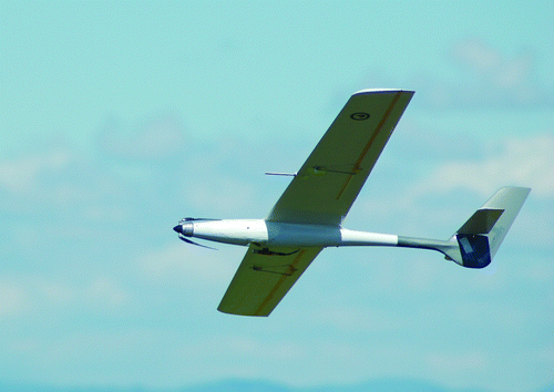
The Kahu UAV is a small (2 metre class) fully composite airframe specifically designed to minimise drag and therefore maximise mission endurance (). The airframe is portable, hand-launched, and recovers to land either via controlled soft-landing or parachute descent. While the UAV can fly for up to 2 hours at a maximum speed of 100 km h−1, cruising speeds of c. 60 km h−1 are more commonly employed. Positioning of the UAV is achieved using a combination of GPS and barometric height and distance plotting undertaken by the autopilot. Information collected by the UAV is transmitted to the ground-station using a FreeWave (902–928 MHz) wireless radio link.
Figure 1 The Kahu UAV during flight. Photograph by D. Ashman, Defence Technology Agency.
Autopilot
The autopilot is the ‘brain’ of the Kahu UAV, providing control, guidance, navigation and communication functions which together with the physical airframe constitute an autonomous robotic aircraft. Autopilot hardware includes sensors for six-degrees-of-freedom inertial navigation, GPS, a pitot-static system and barometric pressure sensors.
Hawk ground control
The Hawk ground control station (GCS) is the graphical user interface for all aspects of the UAS Command and Control process. The GCS consists of a software application running on a notebook computer that maintains the radio link with the Kahu airframe.
Meteorological sensors, data acquisition and capture
In order to collect meteorological measurements of the atmosphere, a Kahu airframe was modified to accommodate a HMP50 combined temperature and humidity probe manufactured by Vaisala Oyj. The HMP50 probe was selected due to its low weight, low power consumption and the performance of its humidity and temperature sensors, which is comparable with industry-standard radiosonde technology (Vaisala Citation2008, Citation2010). Vaisala estimates of accuracy for the probe are ±3% for relative humidity (at 0%–90% relative humidity, increasing to ±5% above 90%) and ±0.6 °C for temperatures between 10 and 20 °C (with accuracy decreasing outside this range). The probe was installed beneath the UAV's wing, 0.06 m from the leading edge (to shield from solar heating) and approximately 0.2 m from the wing root to avoid propeller wash and any thermal effects (). All measurements were collected onboard the UAV at a rate of 8 Hz. The autopilot was programmed to combine the meteorological observations with their corresponding time-stamped GPS data, so the magnitude, timing and location of each measurement were packaged and transmitted to the GCS every 0.25 s.
UAS communication performance in the coastal environment
The sea surface is a significant source of interference to line-of-sight radio frequency (RF) transmission. When operating the Kahu UAV offshore using a shore-based GCS, the Fresnel zone along the RF transmission path will be partially interrupted by the sea surface when the UAV is flying at low altitudes. RF reflection from the water can lead to significant RF multipath propagation and loss of signal at the receiver (Lippincott Citation1998; Shen & Wen Citation2010). In addition, the maritime surface boundary layer (the atmosphere immediately overlying the ocean's surface) may also attenuate RF signals (Sim Citation2002).
To determine the ability of the Kahu UAV to reliably transmit meteorological observations to the GCS while operating in the coastal environment, a field experiment was conducted exploiting locations along the coastline of the Hauraki Gulf, Auckland. Using the same radio transmitters, receivers and antennae used in the Kahu UAS, the performance of the FreeWave radio link was tested over open water in late November 2008 using 12 locations along the coastline (). Five minutes of data were transmitted from a height of 20.5 m above mean sea level (AMSL) southwards from Gulf Harbour to each receiver location. This site was selected as it provided clear RF line-of-site to most of the east-coast beaches immediately north of Auckland. At each receiver location, two processes were checked. First, whether the radio transmission signal from Gulf Harbour could be detected, and second, how much (if any) of the transmitted data could be received.
Figure 2 Transmitter and receiver locations on the coastline of the Hauraki Gulf and Waitemata Harbour, Auckland, New Zealand. Distances between locations and their elevation are detailed in brackets.
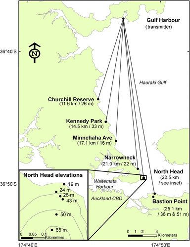
One low-elevation location on the coastline failed to receive any data (North Head, 19 m AMSL). The remaining 11 locations received between 74 and 100% of transmitted data, at distances of up to 25 km across the Hauraki Gulf and Waitemata Harbour. These results suggest that the radio link may be reliable up to distances of 25 km across water with the UAV flying at altitudes above 50 m. With the UAV flying at altitudes below 20 m, our results suggest that the distance between the UAV and the GCS should be no further than c. 12 km for reliable data transmittance.
Comparison of UAS, weather station and radiosonde data
Introduction and experimental design
For observations collected by a UAS to be of any value to researchers, the quality of the data needs to be known with certainty. In previous UAS research, data reliability has been assessed by comparing UAV-collected measurements with soundings and stationary meteorological sensors (Soddell et al. Citation2004; Reuder et al. Citation2009). The Seabreeze 2009 field experiment in the Bay of Plenty, New Zealand (Garrett et al. Citation2011) presented the first opportunity to conduct preliminary flights of the Kahu UAV complete with meteorological sensors. A direct comparison of the meteorological observations collected by the UAV was made against industry-standard sensors at a range of heights below 500 m. This height range was selected as it is of particular importance to planetary boundary layer research, an area in which we see considerable scope for the use of the Kahu UAS.
On 26 February 2009, the intercomparison experiment began on Thornton Beach, Bay of Plenty, with the UAV launched near sea-level (7 m AMSL) at 1831 UTC (0731 local time) into still, sunny conditions. The Kahu UAV flew a spiral-up flight pattern and was programmed to loiter at heights of 75 m, 150 m, 295 m and 436 m collecting atmospheric observations for periods of up to two minutes. To test the accuracy of the ground-level UAV data, simultaneous measurements of temperature and humidity were collected using a Weather-Pro Plus weather station located at a height of 20.05 m AMSL. To assess the accuracy of the UAV results above this height, a radiosonde was launched beneath the UAV flight path, taking care to avoid collision with the aircraft. A Vaisala RS92-SGP radiosonde was paired with a Marwin MW12 receiver for the low-altitude sounding. The radiosonde was calibrated using a Vaisala ground check GC-25 unit to ensure optimum sensor performance (Vaisala Citation2010). A helium weather balloon attached to the sonde was partially underfilled in order to slow the rate of ascent and to optimise the vertical sampling resolution of the sounding (after Bailey Citation2000). Low-level (75 m) observations were collected by the UAV and radiosonde near simultaneously. However, due to the slower ascent of the UAV compared to the weather balloon, there was a 16 minute delay between when the radiosonde reached an altitude of 436 m and when the UAV began sampling at this height. Radiosonde drift in this experiment was negligible (c. 200 m), while the horizontal distance between the sounding and the centre of the UAV flightpath never exceeded 550 m.
Results
Temperature and relative humidity measurements collected by the Kahu UAV were equivalent to those recorded by the ground-level weather station within the 95% confidence intervals of its accuracy (). Similarly, data collected by the UAV up to 436 m AMSL were statistically indistinguishable from those collected using the radiosonde within the 95% confidence limits of both data sets (). Post-flight comparison of the GPS and barometric derived heights from the UAV data suggest that uncertainties in altitude during atmospheric sampling were within ±5%.
Figure 3 Kahu UAV measurements of air temperature and relative humidity from the Bay of Plenty, New Zealand. A, UAV and weather station observations at ground-level (7–23 m AMSL). Horizontal error bars represent sensory accuracy at two standard errors. Vertical error bars represent altitude accuracy at two standard errors. B, UAV and radiosonde observations up to 500 m AMSL. Green solid ellipses represent the mean±two standard deviations in temperature/relative humidity (n=1594) and ±5% altitudinal error. Horizontal error bars represent sensory accuracy at two standard errors (purple broken lines).

Discussion
Above ground-level, UAV observations exhibit a small but consistent warm temperature (c. 0.2–0.4 °C) and dry humidity bias (c. 2%–5%) (). The dry bias in particular increases throughout the UAV flight, suggesting that it may be associated with delays in the UAV collecting data at increasing heights. Previous studies have considered time-lags to be at least partially responsible for discrepancies in UAV measurements of the atmosphere (Soddell et al. Citation2004). Results from the ground-level weather station show that relative humidity decreased from 87.6% to 82.9% during the 18 minute UAV flight; this change is broadly equal to the dry bias in the UAV measurements at 436 m, collected 16–18 minutes after the UAV was launched. While alternative sources of UAV measurement bias could include kinetic heating of the UAV sensors or aerodynamic effects (Soddell et al. Citation2004), the small discrepancies in this study lie within the quoted error ranges of the sensors. As such, no meaningful insights into the potential sources of error in UAV-derived atmospheric data can be made at this time.
The direct comparison of airborne meteorological measurements against independent sensors shows the UAV data to be of sufficient accuracy for research purposes. As such, the Kahu UAS may be used with confidence to complement, or perhaps supplement, radiosonde releases, greatly expanding our capability to accurately study the low-altitude coastal atmosphere. Future research with the Kahu UAS will focus on collecting wind speed and direction measurements during flights, so that the suite of atmospheric information supplied from the UAS may be directly compared with that obtained using traditional radiosonde and weather station hardware.
Conclusions
The Kahu UAS has been successfully employed to collect in situ observations of the low-altitude coastal atmosphere. Using commercially available meteorological sensors, the UAV is capable of collecting both vertical and horizontal atmospheric profiles with the data transmitted to the ground-station near instantaneously for collection and analysis. Field testing of the radio transmission link of the UAS across line-of-sight paths over open water suggests that robust communications may be maintained between the UAV and GCS at distances of up to 25 km. A direct comparison of the Kahu UAVs meteorological measurements with radiosondes and weather stations shows that atmospheric measurements made using the Kahu are accurate at heights up to 500 m. There is some evidence of minor dry and warm biases in the UAS results, though these are likely to be the result of differences in the timing of data collection at higher altitudes. In total, these preliminary findings indicate that there is considerable scope for the Kahu UAS in future studies of the atmospheric coastal environment, providing a new, flexible and reusable research platform for meteorologists in New Zealand.
Supplementary file
Supplementary file: The location and timing of the radiosonde launch and UAV flight during the intercomparison experiment at Thornton Beach, New Zealand
The location and timing of the radiosonde launch and UAV flight during the intercomparison experiment at Thornton Beach, New Zealand
Download PDF (219.1 KB)Acknowledgements
We should like to thank our colleagues at the Defence Technology Agency for their assistance in planning and completing the Kahu UAS field experiments. Mr Daniel Ashman contributed to the integration of the meteorological sensors with the airframe and autopilot and was also the UAV operator for flights in the Bay of Plenty. Additional funding and support for this research from the Office of Naval Research (USA) (Program Element 0602271N) is greatly appreciated. Meteorological equipment used in this study was supplied by the Defence Technology Agency, the New Zealand Met Service (Paraparaumu) and the School of Artillery of the New Zealand Army. Finally, we are grateful to Mr Ian Whaley and two anonymous reviewers for providing thoughtful comments and suggestions on an earlier version of this paper.
Notes
Supplementary data available online at www.tandfonline.com/10.1080/03036758.2012.695280 Supplementary file: The location and timing of the radiosonde launch and UAV flight during the intercomparison experiment at Thornton Beach, New Zealand
References
- Bailey DT 2000 . Meteorological monitoring guidance for regulatory modeling applications. EPA document EPA-454/R-99-005 . United States Environmental Protection Agency, Office of Air Quality Planning .
- Dalamagkidis , K , Valavanis , KP and Piegl , LA . 2008 . Current status and future perspectives for unmanned aircraft system operations in the US . Journal of Intelligent and Robotic Systems , 52 : 313 – 329 .
- Dempsey ME 2010 . Eyes of the Army - U.S . Army Roadmap for Unmanned Aircraft Systems 2010–2035. Fort Rucker, Alabama, USA, US Army UAS Center of Excellence.
- Garrett , SA , Cook , DE and Marshall , RE . 2011 . The Seabreeze 2009 experiment: investigating the impact of ocean and atmospheric processes on radar performance in the Bay of Plenty, New Zealand . Weather and Climate , 31 : 82 – 100 .
- Haack , T , Wang , C , Garrett , S , Glazer , A , Mailhot , J and Marshall , R . 2010 . Mesoscale modeling of boundary layer refractivity and atmospheric ducting . Journal of Applied Meteorology and Climatology , 49 : 2437 – 2457 .
- Holland , GJ , Webster , PJ , Curry , J , Tyrrell , G , Gauntlett , DJ , Brett , G , Becker , J , Hoag , R and Vaglienti , B . 2001 . The Aerosonde robotic aircraft: a new paradigm for environmental observations . Bulletin of the American Meteorological Society , 82 : 889 – 902 .
- Houston , AL , Argrow , B , Elston , J , Lahowetz , J , Frew , EW and Kennedy , PC . 2012 . The collaborative Colorado–Nebraska unmanned aircraft system experiment . Bulletin of the American Meteorological Society , 93 : 39 – 54 .
- Lippincott WL 1998 . Sea surface multipath effects on ship radar radiated power determination . Washington DC, USA, Advanced Systems Technology Branch, Space Systems Development Department.
- Oliver , B 2009 . Could UAVs improve New Zealand's maritime security? Unpublished Master's thesis. Palmerston North, New Zealand, Centre for Defence Studies, Massey University.
- Reuder , J , Brisset , P , Jonassen , M , Müller , M and Mayer , S . 2009 . The Small Unmanned Meteorological Observer SUMO: a new tool for atmospheric boundary layer research . Meteorologische Zeitschrift , 18 : 141 – 147 .
- Shen , W and Wen , BY . 2010 . Experimental research of UHF radio back-scattered from fresh and seawater surface . Progress In Electromagnetics Research M , 11 : 99 – 109 .
- Sim CYD 2002 . The propagation of VHF and UHF radio waves over sea paths . Unpublished PhD thesis. Leicester, UK, Department of Engineering, University of Leicester.
- Soddell , JR , McGuffie , K and Holland , GJ . 2004 . Intercomparison of atmospheric soundings from the Aerosonde and radiosonde . Journal of Applied Meteorology , 43 : 1260 – 1269 .
- Strong P , Ashman D 2008 . Kahu unmanned aircraft system description and user manual . Unpublished DTA manual. Auckland, New Zealand, Defence Technology Agency.
- Vaisala 2008 . HMP50 miniature humidity and temperature probe for OEM applications . Helsinki , Finland, Vaisala .
- Vaisala 2010 . Vaisala radiosonde RS92-SGP . Helsinki , Finland , Vaisala .
- Watai , T , Machida , T , Ishizaki , N and Inoue , G . 2006 . A lightweight observation system for atmospheric carbon dioxide concentration using a small unmanned aerial vehicle . Journal of Atmospheric and Oceanic Technology , 23 : 700 – 710 .
- Waugh , E and Mowlem , M . 2011 . Low cost UAV for ship based science missions . Ocean Science Discussions , 7 : 757 – 772 .