
 ?Mathematical formulae have been encoded as MathML and are displayed in this HTML version using MathJax in order to improve their display. Uncheck the box to turn MathJax off. This feature requires Javascript. Click on a formula to zoom.
Abstract
How are patterns of armed control and dispute by armed actors related to land concentration, land property rights, and distribution? We argue that armed actors affect land tenure by using different land transfer mechanisms to distribute the land, which reflects the dynamics of control and dispute during civil conflict. We test this argument by studying the case of Urabá, a region in northwestern Colombia, using a mixed-method strategy. First, using extensive qualitative fieldwork, we find that armed actors systematically applied different land transfer mechanisms in areas where they held control. Armed actors strategically changed from employing one land transfer mechanism to another in relation to the level of dispute, political and economic objectives, and alignment with the state, among others. In our fieldwork, we identify how these land transfer mechanisms led to patterns of territorial control and land tenure structure. We then analyze an original dataset of rural plot ownership in Urabá, based on official cadastral information, to empirically verify our qualitative findings. We estimate a village-level fixed effects model that shows that disputed territories and those under paramilitary control had larger plots, higher land inequality, and fewer land transfers. In contrast, territories with established control by left-wing insurgents exhibit a small landholder scheme. These results offer important insights into the relationship between civil armed conflict and land and the logic of rebel governance.
¿Cómo se relacionan los patrones de control armado y de disputa por parte de los agentes armados con la concentración de tierras, los derechos de propiedad de las tierras y su distribución? Argumentamos que los agentes armados ejercen un efecto en la tenencia de tierras utilizando diversos mecanismos de transferencia de tierras para distribuir las tierras, lo que refleja la dinámica de control y de disputa durante un conflicto civil. Ponemos a prueba esta hipótesis, utilizando una estrategia de método mixto, a través del estudio del caso de Urabá, una región en el noroeste de Colombia. En primer lugar, hallamos, utilizando un extenso trabajo de campo cualitativo, que los agentes armados aplicaron sistemáticamente diferentes mecanismos de transferencia de tierras en las áreas donde tenían el control. Los agentes armados fueron cambiando, de manera estratégica, el uso entre uno u otro mecanismo de transferencia de tierras en función del nivel de disputa, de los objetivos políticos y económicos, y de la alineación con el Estado, entre otros factores. En nuestro trabajo de campo, identificamos cómo estos mecanismos de transferencia de tierras provocaron patrones de control territorial y de estructura de tenencia de la tierra. A continuación, analizamos un conjunto de datos originales, basado en información catastral oficial, de propiedades parcelarias rurales en Urabá con el fin de verificar empíricamente nuestros hallazgos cualitativos. Estimamos un modelo de efectos fijos en las aldeas que demuestra que los territorios en disputa y aquellos bajo control paramilitar tenían parcelas más grandes, mayor desigualdad de tierras y menor transferencia de tierras. En contraposición, aquellos territorios cuyo control está establecido por insurgentes de izquierdas exhiben un pequeño esquema de terratenientes. Estos resultados ofrecen información importante acerca de la relación entre el conflicto armado civil y la tierra, y acerca de la lógica de la gobernanza rebelde.
Quels sont les liens qui unissent les schémas de contrôle armé et de conflits des acteurs armés à la concentration et la distribution des terres, ainsi que les droits à la propriété foncière? Selon nous, les acteurs armés ont une incidence sur le régime foncier en utilisant différents mécanismes de transfert des terres, qui reflètent la dynamique de contrôle et les oppositions lors d’un conflit civil. Afin de vérifier cette hypothèse, nous appliquons une stratégie aux méthodes mixtes pour analyser le cas d’Urabá, une région au nord-ouest de la Colombie. D’abord, à l’aide d’un travail de terrain qualitatif approfondi, nous observons que les acteurs armés ont systématiquement appliqué différents mécanismes de transfert de terres dans les régions qu’ils contrôlaient. Ils passaient stratégiquement d’un mécanisme de transfert des terres à l’autre, notamment selon l’intensité du conflit, les objectifs politiques et économiques ou leur accord avec l’État. Dans notre travail de terrain, nous identifions comment ces mécanismes de transfert de terres ont engendré des schémas de contrôle territorial et une structure de régime foncier. Ensuite, afin de vérifier empiriquement nos observations qualitatives, nous analysons un ensemble de données original de la propriété des parcelles rurales à Urabá, en nous appuyant sur les informations officielles du cadastre. Nous élaborons un modèle des effets fixe au niveau d’un village qui montre que les territoires disputés, et ceux contrôlés par des forces paramilitaires, se caractérisent par de plus grandes parcelles, une inégalité foncière plus marquée et des transferts de terres plus rares. À l’inverse, l’organisation des territoires non disputés et contrôlés par des rebelles de gauche favorise les petits propriétaires terriens. Ces résultats fournissent des renseignements importants sur la relation entre un conflit armé civil, les terres et la logique de gouvernance rebelle.
Introduction
Many internal armed conflictsFootnote1 take place in agrarian developing economies, where land is a valuable asset. In this context, even if these conflicts are born out of grievances, armed groups may eventually fight for greed—for either case, illegal appropriation of assets and resources becomes common practice (Collier and Hoeffler Citation2004; Centro Nacional de Memoria Histórica [CNMH] Citation2016; Korf Citation2005). In fact, land appropriation becomes an important source of power and territorial domination for armed actors (Bagozzi, Koren, and Mukherjee Citation2017; Beyers Citation2013), boosting inequality and inefficiency in land market transactions (CNMH Citation2016; Wily Citation2009). Surprisingly, whereas unequal land tenureFootnote2 schemes have received ample academic attention as being part of initial motivations and intensifying factors in armed conflict (Esteban and Ray Citation2011; Grossman Citation1994; Luca and Sekeris Citation2012), less is known about the mechanisms tying armed conflict to landholding inequality, land property rights, and land tenure structures. What happens to land concentration during civil conflict? How are patterns of territorial control and disputeFootnote3 by non-state armed actors related to the way in which land is appropriated and distributed in conflict zones?
In this paper, we provide new insights on the relationship between civil conflict and land ownership structure, formality, and distribution, focusing on the case of Urabá, Colombia. This region in northwestern Colombia was particularly affected by the intensification of armed conflict during the 1990s and early 2000s.Footnote4 As a result, thousands of hectares of land were either abandoned or illegally appropriated by different armed groups. Through many mechanisms, different actors sought to formalize their dominion over appropriated land and gain property rights by taking advantage of their influence over local institutions. These illegal land acquisitions are posited to have been used in some cases, as insurance for maintaining groups’ economic and political power during times of potential change in a post-conflict setting (Reyes Posada Citation2009). Furthermore, recent evidence suggests a strong relationship between how land was distributed by landed elites in Colombia, and local levels of inequality and development (Faguet, Sánchez, and Villaveces Citation2020).
The Colombian civil conflict provides leverage to study the general phenomenon of how armed groups’ objectives and goals might shape institutions such as land property rights during and after a civil conflict. As in many conflict-ridden countries, Colombia has a weak state with developing urban centers while state-building has been left behind in the rural periphery, in which non-state actors employ strategies to impose their political, economic, and social control, even after signing a peace agreement. This is the case for communist insurgencies in India and the Philippines currently, and for past conflicts in El Salvador and Guatemala, among other territories, in which the legacy of conflict on social institutions still persists. Thus, our findings might contribute to understanding other contexts as well as armed actors such as other revolutionary groups, despite ideological differences, like anti-authoritarian movements (e.g. Hamas in Palestine, Free Syrian Army in Syria) and politicized religious or identity insurgencies (e.g. Taliban, ISIS, Boko Haram, Hezbollah) (Kalyvas Citation2015; Rubin Citation2020). Moreover, the case of the Colombian right-wing paramilitaries can also be used to analyze the right-wing armed groups in Guatemala and El Salvador (Gross Citation1995; Gutiérrez Sanín Citation2008), for example.
We employ a multi-method empirical strategy to address the endogeneity issue in the relationship between civil conflict and land tenure structure. Using qualitative methods and extensive fieldwork in Urabá, we develop a detailed understanding of the different territorial disputes in the region, emphasizing their spatial distribution using social cartography. By identifying geographical patterns and actors, we were able to uncover the different mechanisms by which land property rights were transferred and concentrated in the region from 1970 to 2011. We focus on understanding the dynamics and motivations of how non-state armed actors may favor a particular land transfer mechanism over another in a particular time and territory.
Based on the qualitative findings, we perform an exploratory quantitative analysis by using an original dataset based on the 2011 land plot census provided by the Cadastral Office of the government of the department of Antioquia in Colombia. This census offers information on the ownership and physical characteristics of each rural plot in Urabá. Even though this quantitative approach does not allow us to study the dynamics or changes over time, it provides a unique opportunity to verify how the different land disputes and control have produced a particular land tenure structure. So, we part from the territorial classification derived from our findings from the social cartography instrument to estimate a fixed-effects model to test how patterns of territorial control and dispute by armed actors are related to the land ownership structure at the micro-level.
Our qualitative findings allow us to build a detailed understanding of the types of armed actors that were present in Urabá between 1970 and 2011, their geographical location, and their strategies and motivation for fighting over land control. In these territories, we find that armed actors used six different mechanisms of land transfer: (i) invasions, (ii) repopulation, (iii) material dispossession, (iv) forced sale, (v) market transactions, and (vi) forgery and identity theft. The use of these mechanisms was not exclusive to a particular actor, they were employed by different actors, sometimes simultaneously and other times, at different times. Our qualitative findings allow us to identify the way in which these dynamics took place, their geographical location, and the potential effect on the land tenure structure in each location. We verify these qualitative insights in the econometric results. We find those territories that have been contested among different armed actors are associated with higher levels of land inequality, fewer plots per owner, and a higher rate of formality in property rights. By contrast, areas with low contestation show less land inequality, more plots per owner, and a lower rate of formality in property rights.
Our study offers four main contributions. First, we contribute to the deeper theoretical understanding of the relationship between armed conflict and land within the social sciences, by developing and testing a theory tying patterns of control and dispute by armed actors to posterior patterns of land ownership and concentration. Most empirical evidence has mostly been interested in the opposite relationship, in which land inequality leads to conflict and unrest, in the vein of the grievance hypotheses (Albertus, Brambor, and Ceneviva Citation2018; Collier and Hoeffler Citation2004; Korf Citation2005; Muller and Seligson Citation1987; Russet Citation1964; Thomson Citation2016). Instead, we approach the issue from the perspective of armed actor governance and the institutions they build (Arjona Citation2016; Berg and Carranza Citation2018; Stewart and Liou Citation2017). Additionally, we inductively identify several types of land transfer mechanisms, and highlight their importance to the study of civil conflict and its aftermath.
Second, we contribute to the simultaneous use of qualitative and quantitative strategies (Seawright Citation2016; Thaler Citation2017), by using qualitative results to code and inform regression analysis, as well as complement it. Territorial control by armed actors is notoriously hard to measure using standard conflict data, since the absence of direct violence can sometimes mean control by a single actor (Kalyvas Citation2006). As an alternative, we use a wealth of qualitative field data from focus groups, interviews, and structured social cartography to assess control and dispute by different armed actors. Third, we analyze new data on the land ownership structure at sub-village (vereda) level for the region of Urabá which allows us to measure micro-level variation in levels of violence and control, and inequality in land ownership. Lastly, our results have implications for peacebuilding and post-conflict democracy, given the importance of property rights in institutional theories of democracy and civil conflict. Our work provides support for the ongoing process of transitional justice based on land restitution in Colombia, and the conclusions can inform debates in other post-conflict settings.
The paper is structured as follows. In the next section, we discuss the underpinnings of the relationship between civil conflict, particularly armed groups’ territorial control and preferences, and the concentration of land ownership, developing testable empirical implications simultaneously. Then, we present the two sides of our empirical strategies. We trace changes in land transfer mechanisms and patterns of control and dispute in Urabá, using qualitative fieldwork. We then analyze an original dataset of land ownership in Urabá, informed by our qualitative findings, and find empirical support for our hypotheses. We conclude by discussing the implications for the literature, post-conflict politics, and avenues for future research.
From Control and Dispute to Land Transfer and Appropriation
Considerable attention has been paid to patterns of control and dispute by armed actors in civil conflicts, particularly after Stathis Kalyvas' (Citation2006) seminal work The Logic of Violence in Civil War. Following Kalyvas (Citation2006, 88), we define control as a (near) monopoly of presence by an actor, violent or otherwise, as opposed to the overlap of this presence, which Kalyvas describes as zones of intermediate or contested control and which we call dispute. As Kalyvas focuses on control and dispute in relation to civilian support and loyalties, this article extends the argument to include the relation of control and dispute to land structure and violence. Territorial control is not limited to matters of coercion and physical control. The recent literature on rebel and militant governance shows how non-state armed actors build institutions, predominantly informal ones,Footnote5 that go beyond the use of violence (Arjona Citation2014, Citation2016; Weinstein Citation2007). This has recently been extended to understand issues of criminal governance (Barnes Citation2021; Lessing Citation2015; Lessing and Willis Citation2019; Magaloni, Franco-Vivanco, and Melo Citation2020). Based on this literature, we suggest that the prevalence of control or dispute in a territory affects what strategies and goals actors pursue. We explore the strategies related to the establishment of rules regarding the distribution and transfer of land in a territory.
Our argument is that patterns of control and dispute by armed actors, and the prevalent mechanisms by which land is transferred, are linked to the structure, distribution, and concentration of land ownership. Whether there is control or dispute influences the type of governance non-state actors employ in relation to the institutions they seek to implement with regards to land distribution. These institutions or land transfer mechanisms are varied, mixing legal and illegal, formal and informal rules, and they change over time. In the end, we argue that the concentration, or lack thereof, of land ownership is a product of these processes.
A key aspect of territorial control and governance is the establishment of institutions, or rules, about the distribution and redistribution of land, which we call land transfer mechanisms. Common examples of land transfer mechanisms defined in this manner include land colonization by settlers in agricultural frontier lands, titling and state-led (re)distribution of land, forced or violent displacement, the market, and even falsification of documents and identities. Though we are not the first to identify these mechanisms (Albertus and Kaplan Citation2013; Bagozzi, Koren, and Mukherjee Citation2017; Grajales Citation2011, Citation2013; Grossman Citation1994), they have not yet been incorporated into a framework relating armed conflict to subsequent land distribution.
The land transfer mechanisms we identify vary along five dimensions. First, we conceptualize these mechanisms as being means to an end, and each mechanism is used with certain objectives in mind, including military expansion, increased legitimacy, rent-seeking, counterinsurgency, social reform, and land redistribution. Second, each mechanism is perpetrated by an actor and serves a beneficiary. These two often coincide, as in the case of criminally-oriented organizations, though they do not have to: an armed actor can forcibly remove land from a group, in order to transfer it and benefit another group, separate from the military organization. Third, each mechanism has its own internal logic–how it operates. For example, material dispossession usually takes place under the use of direct violence exacted on land dwellers (such as forced displacement) (Kalyvas Citation2006). Meanwhile, actors that force owners to sell for risible amounts under threat of direct violence thereafter often utilize land markets to secure property rights over land. Fourth, mechanisms vary in their degree of legality, as in the Rule of Law of the land, and formality, whether formal paperwork such as deeds exist. Finally, there are opportunities that make a mechanism attractive and feasible. For instance, the presence or absence of rival actors as well as the state, can create an opportunity to favor a particular mechanism over others.
Therefore, during armed conflict armed actors can, and often do, set the predominant ways in which land changes hands and how property is divided and structured. Control and dispute impact the mechanisms used by these actors in their place and time. Because of its value, actors in armed conflicts seek to acquire and transfer land through a variety of different mechanisms. Armed actors in civil conflicts have been shown to use different types of violence against civilians (Balcells Citation2010, Citation2011; De la Calle and Sanchez-Cuenca Citation2015; Kalyvas Citation2006). Yet while land transfer mechanisms are frequently carried out using violence, even illegal actors may find it more efficient at times to make use of land markets and formal institutions. Criminal but nonviolent mechanisms—such as the forgery of titles and identity theft, further broaden the repertoire of potential tactics.
Notwithstanding the fact that the choice of land transfer mechanism rests partially on the nature of each actor, other factors such as geographical conditions, level of formalization of land property rights, and state presence, also influence this choice. Armed confrontation has the potential of altering an actor’s preferred mechanism, as the value of land changes and the options to transfer it become limited. This discussion leads to several expectations regarding the use of land transfer mechanisms and the structure of land tenure in conflict areas. First, the choice of mechanism is conditional upon each actor’s objectives and opportunities. In terms of objectives, while ideological and political goals necessitate control over both the physical territory and the population, economic and criminal ones exhibit a reduced need for social control (Kalyvas Citation2006). Meanwhile, opportunities are mainly shaped by the number and relative strength of other actors, as well as their objectives. Increased state capacity through military presence and well-defined property rights reduces the opportunities for successful violent appropriation, and actors seek more subtle ways, such as corrupt practices within state institutions, to acquire and transfer land. Based on this logic, we arrive at our first hypothesis:
Hypothesis 1: Actors use different land transfer mechanisms to bolster particular social orders which lead to a specific land tenure structure.
On the other hand, Rubin (Citation2020) claims that communities with greater collective action capacity (CAC) mobilize information and resources more efficiently, increasing armed groups’ incentives to control territory. Nevertheless, CAC also increments community bargaining power to demand costly investments in governance, partially canceling out these gains (Rubin Citation2020). Furthermore, as state presence increases, communities leverage CAC to demand prohibitively costly rebel governance, discouraging rebel control, and increasing government support (Albertus and Kaplan Citation2013; Rubin Citation2020). For instance, in El Salvador’s armed conflict (1980–1992), regime support was highest in those political subdivisions in which land reform had been implemented and where death squad violence had been subdued (Mason Citation1986).
However, during a civil conflict, increasing state presence may be insufficient to prevent armed actors from imposing a social order by ruling over land tenure structure. Schwartz illustrates this by using the case of the Contra insurgency in Nicaragua (1980–1990): “the obstacles to wartime agrarian reform may not emerge from state weakness or incompetence, but from how strategic wartime imperatives perversely remake the rules of land redistribution and titling” (2022, 1). In this sense, De la Calle and Sanchez-Cuenca (Citation2015) contend that tactics (assassinations, bombings, ambushes, massacres, raids, kidnappings, etc.) and targets (civilians, security forces, politicians, entrepreneurs) vary depending on the type of actor and desired social order. That is, the type of armed group (leftist-guerrillas, paramilitaries, the state) and their military, political, and economic objectives and opportunities may favor certain types of land transfer mechanisms that allow them to impose a specific social order. This leads to our second hypothesis (in three parts):
Hypothesis 2a: In territories with leftist-guerrilla control, they employed land transfer mechanisms to establish a social order that would change the status quo characterized by a less concentrated land tenure structure: smaller plots, more owners, and more transfers in guerrilla-controlled areas.
Hypothesis 2b: In territories with right-wing paramilitary control, they employed land transfer mechanisms to establish a social order that would maintain the status quo characterized by a more concentrated land tenure structure: larger plots, fewer owners, and fewer transfers in state and paramilitary-controlled areas.
Right-wing paramilitary groups’ objectives and opportunities varied over time. In countries like Colombia, El Salvador, Guatemala, and Nicaragua, most of these groups originated as self-defense groups that spontaneously cropped up in response to leftist-guerrilla threats to land and economic well-being (extortion, cattle rustling, among others) (Gross Citation1995; Gutierréz Sanín 2008; Kruijt Citation2008). Some paramilitary groups are pro-government and state-manipulated where “the state seeks to ensure not only that paramilitaries remain under its firm (or relative) control but also that militias do not grow excessively powerful or independent” like with the Loyalists in Northern Ireland (Aliyev Citation2016, 501). However, there are paramilitary groups that turn into powerful independent agents that not only offer services to the state and traditional elites to defend their military, political, and economic interests, but also to serve their own developing interests (Ahram Citation2016; Aliyev Citation2016; Staniland Citation2015). In cases where they are involved in counterinsurgency and land issues, their political objectives focus on maintaining and boosting state and elite control over government; not allowing the left into politics by any means necessary; and applying land transfer mechanisms that trigger economic exploitation and that allow for the maintenance of the status quo and prevent confiscation due to land reform, whether state or guerrilla-led (Gutierréz Sanín 2008; Kruijt Citation2008; Wickham-Crowley Citation1993). Furthermore, they want to limit economic losses and production disruptions for dominant economic groups like traditional elites, large-scale landholders, and large business owners, many of whom were involved politically and militarily in the state and maintain a legally functioning market through which they could buy and sell land uninterrupted (Ahram Citation2016; Gutierréz Sanín 2008). They use their political power for pursuing their own goals, such as appropriating, concentrating, and legalizing land for its leaders and members.
Hypothesis 2c: In territories with disputed control by fighting non-state armed actors, they favored land transfer mechanisms that focused on the minimum military goals and not the maximum goals (maintaining social order, rent-seeking, among others).
Lastly, in disputed territories where armed groups and the state were fighting for control, opportunities were created by a weak state, mostly absent from these territories, as well as informal land rights. These opportunities motivated each side to fight for power and control of the land, as each side attempted to fulfill its own objectives. During this period of disputed control, levels of violence are generally high and the local population is often forced to flee mostly due to material dispossession, forced sale, fraud, and identity theft. It is yet unclear whether the local population tried to protect their land by formalizing land titles or whether they just left in a hurry to flee the violence without formalizing their land. Following Barnes (Citation2021), this disputed land can be called an active threat, where a criminal group (the paramilitaries for their involvement in narco-trafficking and murder of leftist democratically-elected politicians) faces a rival that is intent on taking over a territory in which they operate, using violence or its threat. Based on our fieldwork, we see evidence for this not only when the paramilitaries had become clearly autonomous and criminal but also when they were agents of the state and elites, focused primarily on counterinsurgency and private security. In the following section, we offer a more thorough discussion that clearly links the armed actors and their characteristics to different land tenure outcomes in our study case.
Territorial Control and Land Transfer Mechanisms: The Case of Urabá, Colombia
We use qualitative evidence from extensive fieldwork in the region of Urabá, Colombia, a historical hotspot of land-related violence and civil conflict within the country, to show how land transfer mechanisms have interacted with each other over time and how they are affected by changes in social orders and conflict dynamics. We identify a series of land transfer mechanisms and argue that they are closely related to each other and, at times, occur in sequence (or rarely, even overlap), shaping the changes in the structure of land tenure in Urabá. Based on these qualitative findings, we illustrate hypotheses 2a–2c by using quantitative analysis to estimate the direction of the relationship between territorial control and land ownership and concentration in the region. We argue, based on the evidence, that both patterns of control and dispute by armed actors, and the prevalent mechanisms by which land is transferred, are linked to the structure, distribution, and concentration of land ownership.
We study Urabá for a few reasons. Urabá witnessed the formation and expansion of some of the main left and right-wing non-state armed organizations in Colombia, meaning that partly, the armed conflict originated there. Urabá is an exemplary case of the canonical causes of civil conflict: an unequal land tenure endowment concentrated by the rich, peasant land deprivation, forced displacement, lack of state presence and allocation of basic services, lack of democracy, reduced opportunities for most of the population, extreme socio-economic inequality, and poverty. Furthermore, this list of causes cannot only be found in Urabá or Colombia, but resonates with many other conflicts around the globe, for example in El Salvador, Guatemala, Nicaragua, Peru, the Philippines, Nepal, and Sudan, among others. For these reasons, studying Urabá can aid in the study of other agrarian and inequality-based armed conflicts, as well as conflicts between left and right-wing armed groups. Urabá is a critical case—as a local community leader put it: “Urabá is a laboratory for Colombian reality: everything that happens in the rest of the country happens here first” (2011).
Qualitative Data and Methods
We conducted extensive fieldwork between March and August of 2011, just before the signing of the peace agreement between the Colombian government and the main left-wing guerrilla group, the Revolutionary Armed Forces of Colombia (FARC).Footnote7 We complemented this with secondary sources in both Spanish and English. Along with the regional Peace Commissioner’s Office, other scholars, and local contacts in Urabá, we built a purposeful and well-informed qualitative sample (Coyne Citation1997), composed by high-ranking ex-combatants from the main armed actors involved in the conflict in Urabá: military, leftist-guerrilla groups, and right-wing paramilitaries. We also included other actors such as civil society, the private sector and business owners, and governmental offices. We focus on understanding the dynamics of the non-state armed groups; though the state is an essential actor, we did not find substantive evidence on its role given their weak presence in Urabá in the period of study. describes our qualitative sample.
Table 1. Qualitative sampling.
Given the actors’ availability, mobility, and relevance to the issue, we used three different qualitative instruments for data collection: (i) informal interviews, (ii) life histories, and (iii) focus groups.Footnote8 In all cases, we employed a social cartography approach in which actors were asked to build a geographical representation along with their narratives. Each actor was invited to identify where the different territorial disputes took place on a physical map, and the role of the mechanisms through which land was transferred. Then, all geographical representations were digitized and discussed during an expert workshop, in which we built a consensus on the geographical representation for each period.
When both security and mobility allowed it, we carried out interviews and meetings at neutral places (e.g. hotels or cafés). In cases where the presence of army members or any hierarchical actor was necessary (e.g. when we did interviews of certain high-level ex-combatants), we asked to have a private room only for the interviewees and interviewers. Two members of the research team conducted each interview: one held an active role, interacting with the interviewee and leading the discussion, while the other held a passive role and kept a detailed field diary. In some cases, with permission of the interviewee, we were able to record the interviews, but in other cases, for security reasons, some actors did not consent. In these cases, a hand-written interview log served as the data-collection device. Recordings, logs, and field diaries were transcribed and manually coded.
To reduce bias during the coding process, we randomly assigned the analysis of each instrument to different members of the research team. Additionally, once we agreed upon the most important emerging categories, we randomly cross-checked the categorization of some instruments to avoid coding errors. Finally, to minimize potential researcher bias, we held meetings and forums with academic experts and actors immersed in the reality of the region to share and receive feedback on our findings.
Land Disputes and Armed Conflict in Urabá
We identified five periods in the recent history of civil conflict in Urabá (1970–2011): for each period, we characterize actors with an active role in the conflict, the geographical location of territorial disputes, and the land transfer mechanisms that armed actors used. The periods include the early stage of civil conflict (1970–1991); the demobilization of old non-state armed actors and the arrival of new ones (1991–1994); the emergence and consolidation of paramilitarism in the region (1994–2001); paramilitary hegemony and their demobilization (2001–2006); and the influx of new criminal groups and the initial land restitution processes (2006–2011).
The mechanisms of land transfer used by non-state armed actors during this period were land invasions and squatting, the buying and selling of land in the market, material dispossession, repopulation, forgery and impersonation, and forced sale. Land titling by the state is a factor that runs through these mechanisms, sometimes being a legal formal outcome, sometimes an illegal but formal outcome, sometimes a legal but informal one, and finally, sometimes none of the above. Our findings show the type of land transfer mechanism chosen by actors at a specific point was the result of the territorial, political, and economic objectives and opportunities they faced in each period. That is, the two elements, time-period and land transfer mechanisms, are tied together by patterns of territorial control and dispute among non-state armed actors.
Before 1950, Urabá constituted an agricultural frontier with dense tropical forest and flooded soil that needed significant investment to become productive.Footnote9 During this time, although large investments to break the land were taking place, farmers would come and colonize this unproductive, mostly state-owned land by setting up homes and working the land for themselves. Initially, this colonization was informal, but eventually land formalization laws allowed these small-scale farmers to formalize land titles, based on their continued length of time working their land.Footnote10
The first non-state armed group in the region of Urabá was the Popular Liberation Army (EPL), who appeared in the early 1970s, as a result of the increase of syndicalism associated with the agro-industry. Later, in 1975, the FARC arrived as well. To expand their social and territorial control, both groups promoted massive land invasions and squatting of both state and privately-owned land by civilians. This process started in the mid-1970s, extending into the late 1980s. They had two main goals. First, they sought to implement informal land reform in the area by invading stagnant, abandoned or otherwise unproductive private property that was well-located (close to roads and urban centers) but in areas relatively abandoned by the state, redistributing it to civilian sympathizers (see Rubin Citation2020). Second, it motivated these leftist armed groups to hold increased territorial and social control, though illegally and informally, with the eventual goal of governing these populations and areas (see Stewart and Liou Citation2017). For small-scale farmers who sympathized with either group, it was an opportunity to occupy land and make a better living.
One of the most emblematic cases of land invasions in Urabá happened in 1983–1986 at the hands of EPL militants and sympathizers (Muñoz Mora et al. Citation2021). After squatters took over half of the 4000-hectare plantation owned by COLDESA, a Colombian-Dutch company, privately-hired paramilitaries tried to take the land back. The EPL offered military support to the squatters and after 1986 divided the land among a cohort of their supporters and sympathizers (mostly made up of laborers and small-scale farmers). In the cases of land invasions of state-owned land, eventually, as with colonization, the farmer could get a legal and formal title to the land, if they could show their continuous permanence on the property.
While the EPL managed to maintain control in northern Urabá, FARC controlled the south as well as the region’s periphery. Due to the state’s weak presence in these areas, there was space for non-state actors to rule the region. In the late 1980s, the national political context (a new coming constitution and negotiations with several insurgent groups) provided EPL leaders with incentives to demobilize and create a political party, though members and former combatants were subsequently targeted by the FARC and new paramilitary groups (Steele Citation2011).
By the late 1980s, as guerrilla groups were at the height of their territorial control of Urabá, large landowners got together to form the Peasant Self-Defense Forces of Córdoba and Urabá (ACCU) in 1989. Initially, these groups were hired as private security for landowners, but then gradually through the 1990s into the 2000s, turned into independent groups pursuing their own economic and political interests by offering, for example, protection and security services to industries and civilians (like narco-traffickers). The expansion of the ACCU was also triggered by newly-founded legal, government-sponsored security and policing groups known as Vigilance and Private Security Cooperatives (CONVIVIR),Footnote11 who became an important ally for the ACCU (Kalyvas and Arjona Citation2005). After a few years, paramilitaries were able to repopulate areas that were formerly EPL-dominated territories. Their opportunities were based on their continuous “prestige”: their previous legality, continued social acceptance by a large segment of the population, and their previous ties to the state and traditional elites. Furthermore, due to the weak state presence in most rural areas, their actions were typically hidden from full view.
After 1994, the armed conflict between the two powerful ACCU and FARC was characterized by the use of several strategies: direct military confrontation; selective and indiscriminate violence against those suspected of aiding the enemy; displacement from and repopulation of vacated areas; and alliances among actors, such as the state, industrialists, and narco-traffickers. In 1997, the ACCU united with several other paramilitary groups from different regions and became an umbrella organization called the United Self-Defense Forces of Colombia (AUC). At this point, the organization had expanded and consolidated itself on a national scale and became fully autonomous. Paramilitary violence was used to consolidate their territorial control, destroy efforts at institutional reform, sabotage any peace efforts, protect and engage in narcotics production and trafficking, and to ensure impunity from state prosecution (Tate Citation2001). In Urabá, they pushed FARC further into the periphery, while they controlled the core and the region’s production centers.
As narco-trafficking became more prominent and profitable, the paramilitaries became involved as rent-seekers and adapted their military objectives accordingly by fighting other groups involved in narco-trafficking (like the FARC or ELN) and seizing land for both illegal and legal economic purposes. The paramilitaries would engage in political violence to meet their needs or be paid to do so for other groups while also hoisting up their own political candidates through corrupt or violent means, anything to maintain the status quo and prevent the left from gaining political power. They would use their political power for pursuing their own goals, such as appropriating, concentrating, and legalizing land for its leaders and members.
During this period, the logic of land appropriation and transfer shifted. Neither the FARC nor AUC promoted mass land invasions. Instead, they both sought to control land and territory by forcefully dispossessing civilians through selective and indiscriminate violence as they both expanded their narcotics production and trafficking (the paramilitaries more for “greedy” personal enrichment of its “cadre army” and the FARC more to finance the military operations of their “mass army”, still mostly focused on their political and social motivations but now more influenced by economic reasons [Gutiérrez Sanín Citation2008]). This resulted in a major humanitarian crisis, with thousands dead and displaced (CNHM 2016; UARIV Citation2020). In Urabá, we observe two logics of displacement (García de la Torre and Aramburo-Siegert Citation2011; Steele Citation2011). First, as “collateral” damage, when the objective of non-state armed actors is territorial control for some type of gain (political or economic) and their strategies include terrorizing citizens. As a reaction, the population flees and seeks refuge elsewhere. In the second logic, dispossession is the objective of the conflict, fixed on defeating the enemýs social bases and appropriating their land for themselves, through collective threats and aggression. This land is then used for productive projects, legal and illegal, and could even be formally titled by the state through various processes, “apparently” legal or fraudulent. Multiple opportunities are produced by state weakness and corruption of land agencies, widespread informality in land tenure, and the lack of law enforcement.
Additionally, they began using a tactic known in the region as “repopulation” as a mechanism for transferring land. One group would dispossess civilians and supporters of the enemy side and would then redistribute that land to their own members or supporters. Though former combatants indicated that this tactic was employed by both FARC and AUC, it was more commonly used among FARC fronts in the region as a form of land reform that benefited their social base. Most interviewees, especially military personnel and demobilized guerrilla members, recognized the strategic intentionality behind repopulation. The new inhabitants on repopulated lands were either sympathizers or family members, some of whom were even victims of previous dispossession. As opposed to instances of invasion, the intentions of these armed groups were not to define the property rights of these new tenants, but to exercise control and power over a territory where supporters could live safely, regardless of the legal status of the land. This mechanism therefore acted as an alternative form of armed group-led land reform biased towards their supporters, while causing the displacement of others. Repopulation has only been used sparingly in more recent times (after the mid-2000s and the demobilization of the AUC), however.
Land structure changed drastically in this setting when economic reasons became more prominent than political ones for both left and right-wing non-state armed actors. Small-scale farmers living in strategic areas were removed violently, bought off forcefully, or were victims of fraud and identity theft, and often threatened by both sides. Urban populations were not better off: for example, civilians in the central municipality of Apartadó were displaced on a massive scale, mostly due to their political preferences toward the left (Steele Citation2011). Entrepreneurs and small-scale businessmen who owned ranches and plantations in Urabá were forced to close or sell. Alternatively, they paid AUC, FARC or both for their protection. Speculators took advantage and bought land on the cheap with the expectation of selling afterwards, while others expanded their own landholdings. Drug lords amplified their operations, often using the newly vacated land for their benefit. Finally, paramilitaries undertook a massive process of land grabbing using land transfer mechanisms based on land markets (Grajales Citation2011, Citation2013).
During this period, the transfer of land via material dispossession, forced sale, fraud, and identity theft, was the main motivation for territorial disputes and armed conflict. The opportunities already mentioned remain relevant, those of: state weakness and corruption of land agencies, widespread informality in land tenure, the lack of law enforcement, high impunity for fraudulent and identity theft-related crimes, as well as narco-trafficking and extortion. Mechanisms such as forced sale and fraud and identity theft created gray areas of legality and formality, though sometimes hard to prove due to the legal and formal-appearing paperwork produced, which benefited the non-state armed groups, and even other groups who took advantage of the impunity-ridden environment. These land transfer mechanisms remain a problem today as there have not been big changes made to the opportunity structure.
A demonstrative case of material dispossession is the case of 4,000 people from the collectively titled Afro-Colombian Community Councils of Jiguamiandó and Curbaradó (department of Chocó, close to Urabá of Antioquia) that were displaced in 1997 by the paramilitaries to Urabá’s municipalities of Turbo and Mutatá (Muñoz Mora et al. Citation2021). This case is one of the largest cases of material dispossession in the history of Colombia. Shortly thereafter in 2001, private companies, with the help of the state, planted African palm and set up their business in these same areas, in some parts formally but illegally and in others illegally and informally (Muñoz Mora et al. Citation2021).Footnote12 One can see from this example how the paramilitaries, along with the state’s help, prioritized large business interests over the population, even using illegal and informal mechanisms to reach their goal. Furthermore, according to García de la Torre and Aramburo-Siegert (Citation2011), one outcome of material displacement has been the destruction of cultural territorialities in the region.
One exemplary instance of forced sale to the paramilitaries is the case of five of the best estates in Turbo totaling almost 200 hectares of fertile land: Las Margaritas, El Consejo, Puertorriqueño, Nueva Ilusión, and Los Claveles. The owner received under threat of a risible price of 11 million Colombian pesos (COP) (nearly US$10,000)Footnote13 for his land in 1996. In 2000, that land had ended up being united to another estate (into a total of 410 hectares) and titled in the names of the wife and daughter of notorious paramilitary leader Carlos Castaño (Verdad Citation2009). This is just one example of many that show how forced sale was used to economically benefit a paramilitary leader and his family.
Finally, fraud and identity theft by non-state armed groups and other private groups produced land transfers in apparently legal ways with the help of state officials working for INCODER,Footnote14 the Office of Registration of Public Instruments, and notaries, among others. For example, there existed “parallel” or “ghost” regional INCODER offices where documents were forged in order to take away, change or transfer titled land, often public land (Muñoz Mora et al. Citation2021). Also, people would falsify powers of attorney and contracts of sale, among others, to make transactions possible through notaries and public registration offices. Lastly, identity theft would take place using forged documents and claims of being that person. Though violence was minimal with this mechanism, armed actors, including the state, were often involved and the outcomes for the victims were stark.
By 2001, the AUC had obtained control over most of Urabá. A regional public official in the municipality of Apartadó said it plainly: “During this period, Urabá was paramilitarized” (2011). This period witnessed paramilitary hegemony throughout the region as the FARC retired further into the periphery. The AUC imparted justice, resolved citizens’ private disputes, and provided security, creating an alternate governing order in the absence of state control (Rivera and Duncan Citation2018). But just as they had reached hegemonic power over the territory, in 2002, AUC leaders entered negotiations with the government of President Álvaro Uribe, which led to their demobilization and reintegration into civil society (Valencia Agudelo Citation2007). By 2006, the last of the nation-wide paramilitary structures had turned their weapons in to the state. Former AUC combatants were granted amnesty, while those in commanding positions were offered reduced incarceration sentences.
The demobilization of the AUC did not mean a stop to the violence, nor did it imply the regularization, legalization, or formalization of land transfers in the region. Paramilitaries had taken advantage of their increased control to dispossess, annex, resettle, buy, merge, and exploit land with relative ease, all with near-perfect impunity given lack of enforcement and the coercion of local authorities. They used this land to develop agro-industrial projects and for cocaine production and trafficking (CNMH Citation2016; García de la Torre and Aramburo-Siegert Citation2011; Giraldo Ramírez Citation2011). As demobilization loomed closer, AUC leaders started buying land on a massive scale and investing in agro-industrial enterprises as a way of keeping their assets safe from the state. As reiterated by a local journalist as well as a regional community leader: they vied to make this process appear legal by buying off local state officials, forging documents, impersonating legitimate owners, forcing owners to sell under threat, and sometimes formalizing their acquisitions with government-sanctioned titles (2011). As the same community leader pointed out: “it was not so much due to the weakness of the state, but its collusion.” This led to penetration of illegality into otherwise legal activities, especially African palm oil production.
The demobilization of the AUC left a void: security services and illegal markets were still required to ensure the continued production and transport of illicit drugs, but the AUC’s system of protection had broken down (Nussio and Howe Citation2016). New criminal structures, collectively known as emerging criminal gangs (BACRIM), sometimes partnered with FARC in the drug trade and provided safe passage for shipments. In addition to drug-related activities, other forms of criminality peaked. Paramilitary control had provided security and “pacified” the region from the leftist-guerrillas, but with them gone, and despite increased state presence, independent criminal organizations had more opportunities to expand (often made up of former paramilitaries). In 2011, the Colombian Congress approved Law 1448 (known as the Law of Victims and Land Restitution), requiring the state to compensate victims of the conflict through restitution of their land. However, this law has been criticized for not going far enough nor being fast enough to repair all the victims (Muñoz Mora et al. Citation2021). In short, despite the demobilization of one of the main non-state armed actors as well as government efforts to protect and restitute property rights, there have been failures on the statés part and vested interests in the control of land are still prevalent in the region.
In the case of disputed areas, at a point in the 1990s, the EPL and FARC, though both leftist-guerrillas, began fighting against each other. They had similar incentives and objectives, but still became adversaries. However, disputed areas were mostly between either EPL or FARC against the paramilitaries, sometimes alongside the state. While the conflict in Urabá was still based on military and political objectives, the mechanisms used were mostly invasion, repopulation, and the market. However, once narco-trafficking and extortion really took a foothold in the late 1990s and the objectives became primarily based on criminality and economic gain, the mechanisms of material dispossession, forced sale, and fraud and identity theft became the most utilized.
Finally, the case of the property known as La Joba highlights how several land transfer mechanisms can interact with each other. In 1986, Cristobalina Martínez bought a 70-hectare farm in the municipality of Necoclí, in northern Urabá. Later in 1993, paramilitaries displaced the Martínez family. More than a decade later, on May 10, 2007, INCODER emitted Resolution 0413, which included the property in the registry of abandoned rural land plots due to displacement, supposedly guaranteeing that no further transfers would take place. However, in December of that year, INCODER awarded the “vacant” lot to Luis Alberto Echeverri through Resolution 3605. However, in INCODER archives, the resolution registered under that number alludes to another case altogether. According to an interviewed INCODER official, the May 2007 resolution is fake. However, it has an appearance of legality, to the point that the regional Office of Public Instruments legalized it and has it registered in their archives. In a last episode in this saga, in 2009, Mr. Echeverri transferred the property to some relatives, who then proceeded to sell it to a third party. The case is still contested and unresolved and showcases the dynamics of land transfer mechanisms in the region.Footnote15
Territorial Disputes and Land Transfer: A Social Cartography Approach
Our qualitative work has allowed us to identify the main changes in the logic of territorial control over time, as well as its geographical distribution. Geographically, we identify three areas according to the aggregate dynamics of actor presence and territorial control: (i) areas of EPL and, later, paramilitary control (ACCU/AUC), (ii) historically disputed areas by all armed actors involved, and (iii) areas of continued and mostly undisputed FARC control. shows their spatial distribution.Footnote16 Out of the 653 villages (veredas) in Urabá, 5.9% are in zones with defined territorial control as described by (i) above, 59.4% in zones of territorial disputes between non-state armed actors, and 12.5% in zones historically under control of the FARC ().Footnote17 The disputed zone was the main theater of armed confrontation between guerrilla groups and paramilitaries, often alongside the state.
Figure 1. Spatial distribution of territorial disputes in Urabá. Notes. This map shows the spatial distribution of territorial disputes in Urabá during the last 50 years. The distribution was created based on qualitative interviews. The yellow color stands for territories historically controlled by the FARC; the green stands for those territories under dispute between the paramilitaries (AUC) and guerrillas (FARC); and the orange stands for those territories with defined control by either EPL (1970–1992) or AUC later on. Source: authors’ calculation based on qualitative fieldwork.
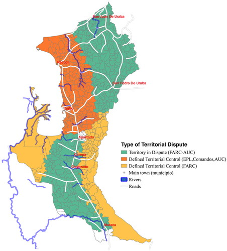
Table 2. Descriptive statistics.
In this section, we presented the findings of our qualitative analysis, based on extensive fieldwork, of the dynamics of territorial control and land transfer in Urabá. We identified five periods and the changes in the mechanisms used by non-state armed actors to transfer land during these periods, as well as the changing patterns of territorial control and dispute in the region. In doing so, we brought in a temporal dimension to our analysis (Brockett Citation1992). These mechanisms are deeply interrelated—the qualitative evidence demonstrates that each mechanism functions as a link in a long chain of land transfer. Land can move from legality to illegality and back, considering the lack of formality in property rights, the weakness and lack of state presence in the region, as well as the ongoing armed conflict and presence of organized crime and narco-trafficking groups.
Our social cartography results show that each mechanism sought to promote a particular social order (Hypotheses 2a–2c) that changed through time: the territorial, political, and economic objectives and opportunities that each actor faced during each conflict period. Besides the dynamics of these mechanisms, we found a clear pattern related to the conflict timing and type of actors involved. When territorial control was not well-defined, all actors favored land transfer mechanisms that allowed them to impose their military predominance (Hypothesis 2c) (forced displacement and so on). Once a territory was under the control of a particular actor, for example, right-wing non-state armed groups favored land transfer mechanisms seeking a social order that maintained the status quo (Hypothesis 2b), while leftist-guerrilla group control favored those mechanisms that changed the status quo (Hypothesis 2a).
A stylized narrative of the changes in which land has been transferred in the region starts with 20th-century colonization of land by refugees, small-scale farmers, and agro-industrial companies. Afterwards, guerrilla groups began sponsoring the invasion of land for their supporters, redistributing land, and creating alternative social orders in the region. With the appearance of paramilitary groups in the 1980s and 1990s as well as changes in the nature of the conflict (towards rent-seeking and criminality), new mechanisms emerged. Violent material dispossession and repopulation dominated the late 1990s and early 2000s, while forced sale and forgery and identity theft have become increasingly relevant as criminal economies thrive. Running through this narrative are both the market exchange of properties and the titling of land by the state. Similarly, we have shown that violence has been equally transversal. Finally, with the qualitative data we collected on the spatial distribution of control and dispute among non-state armed actors in Urabá, we built the main independent variable of interest for the quantitative analysis we present in the following section.
Empirical Analysis: Land Ownership Structure and Control in Urabá
Our qualitative findings allow us to understand the dynamics and prevalence of the different land transfer mechanisms across Urabá. In this section, we verify these insights by using a descriptive analysis based on an original dataset of land ownership in Urabá at the sub-village (vereda) level in 2010. Even though this cross-section approach does not consider the dynamics of this relationship, it offers a unique opportunity to understand how land transfer mechanisms might lead to particular land tenure structures. Although we cannot claim any causal link, this approach offers an exploratory way to contrast our hypotheses. We present the results of a statistical analysis of this relationship and discuss its implications.
Quantitative Data and Methods
We use a 2011 plot census for Urabá, based on cadastral information provided by the departmental government of Antioquia. This census gathers information on the owners, the physical characteristics of the land, and the registration of any formal titles or deeds at local notaries. We aggregated data at the vereda level, which is a small rural population center and constitutes the lowest level of administrative division in Colombia.Footnote18 According to the latest census of veredas carried out by the government of Antioquia in 2010, Urabá had 713 veredas. We were able to match 653 of those to our cadastral dataset.Footnote19 While our dataset cannot provide any evidence on how land tenure patterns changed over time, it provides exploratory insights on the relationships discussed in our theory as well as the qualitative findings.
We built three different indicators for land tenure structure. First, we aggregated information at the owner level, summing up the number of plots and hectares (ha) belonging to the same individual in a given vereda. With this data, we built two indicators for a given vereda: (i) the number of hectares per owner and (ii) the number of plots per owner. On average, landowners had 52.13 ha of land distributed in 1.3 plots. Nonetheless, the high standard deviations suggest important heterogeneity in owners (). Second, following Ibáñez and Muñoz-Mora (Citation2010), we built an index of informality in land property rights, defined as the area of informal properties over the private cadastral area (in ha), as an indicator of the state of land property rights in every vereda. On average, 34% of the plots do not have a formal title in Urabá.
Third, we built two Gini indices for land at the vereda level. First, we considered each plot without considering the owners: we call this the Gini coefficient of Landholdings. Second, we summed all the properties belonging to the same owner in a specific vereda and then estimated the index, which we call the Gini coefficient of Land Ownership. In general, we found that higher concentrations of land ownership were located in the northern areas of Urabá, a strategic area close to the sea.
Finally, as our main variable of interest, we coded and built a set of dummy variables indicating whether or not a given vereda belongs to a territory in dispute described by our qualitative findings in the previous section. After a triangulation process among actors and sources, we built a geographical representation of the land disputes from 1970 to 2011, which was validated during a workshop with experts and stakeholders. Finally, we use information on displacement provided at the vereda level by the government of Antioquia for 1999–2006. We found that 56% of the veredas had at least one person displaced, while 65% received displaced people from other locations. shows the principle descriptive statistics.
In order to approach the relationship between land tenure structure and territorial control in Urabá, we estimate the following equation:
(1)
(1)
The sub-index m refers to the municipality, i to the corregimiento, j to the vereda, and is the land tenure outcome. We consider five different approaches: (i) Gini coefficient of Land Ownership, (ii) Gini coefficient of Landholdings, (iii) number of hectares per owner, (iv) number of plots per owner, and (v) Land Tenure Informality Index. As our main variable of interest, we introduce a set of four dummy variables:
which indicate the main territories in dispute described by our qualitative findings;
is a vector of geographical and displacement controls at the vereda level, which includes: (i) distance to the sea (in kilometers [km]), (ii) distance to the main road (in km), (iii) number of displaced people received (1995–2011), and (iv) number of displaced people emitted (1995–2011).
The term includes a set of fixed effects at the municipal and corregimiento levels to control for different potentially unobservable characteristics that could possibly bias our estimates.
Given that most local political decisions are taken at the municipality level, we argue that these fixed effects control for fixed municipality and corregimiento conditions that could be correlated with the different territorial disputes, making some veredas more prone to territorial disputes than others. Thereby, our main source of spatial variation is within the corregimiento level.Footnote20 Given the low level of disaggregation and proximity,Footnote21 our data may be spatially correlated.Footnote22 Therefore, we estimate the error term,
in two different ways. First, as a benchmark, we estimate robust standard errors corrected for clustering at the municipal level; second, following Conley (Citation1999), we allow for spatial dependence of an unknown form, correcting our standard deviation for spatial correlation.Footnote23 Both standard deviations are reported in the results tables, the former in brackets and the latter in parentheses.
Territorial Disputes and Land Tenure Structure: Quantitative Results
Our quantitative results show an important and statistically significant correlation among the different types of territorial disputes and the structure of land tenure in Urabá. Our results are robust to the introduction of additional controls, as well as the implementation of an alternative specification in the dependent variable. We present two specifications for each land tenure outcome: first, we estimate EquationEquation (1)(1)
(1) without additional controls at the vereda level,
and without corregimiento fixed effects; after that, we fully estimate EquationEquation (1)
(1)
(1) , which we use to make inferences.
shows the results for the two land Gini indices. We find a significant relationship between levels of inequality and land tenure in territories under dispute between FARC and AUC. On average, veredas located in those territories have levels of land ownership inequality up to 0.41 standard deviations higher than an average vereda. Similar results were found for the Gini coefficient for Landholdings (0.50 standard deviations; see Column IV). Territories with defined FARC control are strongly significant once corrected for spatial correlation. These territories also exhibit lower levels of land inequality (0.26 standard deviations less in the Gini coefficient of Land Ownership).
Table 3. Land and territorial disputes: results for land Gini Indices.
shows the results for the two indicators of land ownership. We do not find strong results for the number of hectares per owner. In line with our previous results, however, we find that disputed southern territories have owners with more land (0.37 standard deviations higher than the average). We also find a pattern in the number of plots per owner. Whereas disputed territories in the north are related with fewer plots per owner (0.23 standard deviations less), in disputed territories located in the south we find more plots per owner (0.26 standard deviations more). This can be explained by the level of contestation by paramilitary groups in the south, where more agro-industry is located. Moreover, territories under historical FARC control are correlated with fewer plots per owner (0.23 standard deviations less). Other controls are only significant after correcting for spatial correlation in the residuals.
Table 4. Land and territorial disputes: results for ownership.
Finally, shows the results for the Land Tenure Informality Index. Interesting results emerge from this analysis. Veredas located in territories under FARC control exhibit higher levels of informality in land property rights (0.95 standard deviations) while disputed territories show lower levels of informality (0.72 standard deviations).
Table 5. Land and territorial disputes: informality of land property rights.
Taken together, these results support our argument that armed conflict and territorial control are strongly associated with the structure and distribution of land in Urabá. We identify two patterns in the current structure of land tenure in the region. Veredas located in territories marked by territorial disputes between the FARC and AUC (and previously EPL) have higher levels of land inequality, owners with fewer plots, and less informality. Those located in areas of defined FARC control show less land inequality, more plots per owner, and increased informality in property rights. In the conclusion, we discuss some of the implications of these findings.
Conclusion
In this paper, we have shown that armed conflict and territorial disputes are related to an inefficient land tenure structure in the region of Urabá in the department of Antioquia in Colombia. We do this by using a multi-method approach: qualitatively assessing the nature and logic of land transfer in the region, and quantitatively estimating the relationship of armed conflict and territorial control on the structure of land ownership at the micro-level (vereda). Our central argument is that changes in the objectives and opportunities for territorial control by non-state armed groups are key to understanding the changes in land transfer mechanisms and the structure of land tenure in contexts of violent civil conflict. In the qualitative approach, other important variables that can affect land transfer and tenure are: informality in land rights, state weakness (e.g. corruption, lack of law enforcement, impunity), military-political incentives of different armed groups, and economic incentives (greed) of any type of actor.
We identified five historical periods between 1970 and 2011 that coincide with important shifts in the logic and dynamics of land transfer and armed conflict in Urabá. Within this historical context, we have identified eight land transfer mechanisms in use (the five in italics were mostly committed by non-state armed groups): colonization, allocation of public land titles, land market, invasion, repopulation, material dispossession, forced sale, and forgery and identity theft. These mechanisms coincide with different periods of time, sometimes overlapping, and depend on the opportunities offered by the armed conflict and the actors involved. Furthermore, a plot of land could potentially go through any or all these mechanisms at various moments in a chain-like sequence.
We use the results from this qualitative approach to inform our quantitative analysis. We analyze an original dataset of rural plot ownership in Urabá, based on state cadastral information. We analyze the relationship between armed conflict and land concentration in the region. The results of a fixed effects model show a substantively and statistically significant association between the different types of territorial dispute and the structure of land tenure. This analysis matches and boosts the conclusions derived from our qualitative work. However, due to a lack of pre-conflict data and clear identification, we cannot make strong causal claims.
We identify two patterns in the structure of land tenure in the region, which are tied to control and dispute by armed actors. Veredas located in areas marked by territorial disputes between FARC and AUC (and previously EPL) have higher levels of land inequality, fewer plots per owner, and a higher rate of formality. This is especially important when looking at the FARC-AUC territorial dispute in the south of Urabá. From this, we conclude that as these areas saw more conflict and paramilitary influence, land became more concentrated through the various mechanisms we identify. Since maintenance of the traditional status quo (protecting large landholders and maintaining the state’s power) was one of the AUC’s objectives, we see that they were partly successful. In contrast, those veredas located in historically FARC-controlled territory show less land inequality, more plots per owner, and increased informality in property rights, boasting a small landholder scheme. These territories had lower levels of conflict due to consistent and dominant control by one group. This made it possible for FARC to partially achieve one of its main stated goals: informal land reform for small-scale farmers (though they did not have the authority to legalize these land reforms). These results tie in with work highlighting the importance of ideology in civil wars (Gutiérrez Sanín and Wood Citation2014).
On November 24, 2016, the FARC and the Colombian government signed an ambitious peace agreement, where land reform was a central tenant. There have been general decreases in civilian deaths and land displacement since then, though violence and tensions still continue due to the persistence of narco-trafficking, weak state presence in rural regions, and the complex process of land restitution. From 2010 to the end of 2019, according to the Colombian non-governmental organization Programa Somos Defensores, 746 social leaders and people in process of land restitution have been assassinated in Colombia, of whom 515 were killed during the post-agreement period from 2016 to the end of 2019 (Programa Somos Defensores Citation2022). Of the 8,078,127 registered victims of internal land displacement in Colombia (1985–2020), the government barely touches this number in terms of land restituted per year, which stays in the low hundreds of thousands (UARIV Citation2020). Though these numbers are staggering, the government is yet to proactively take a stance against the assassinations or increase resources for land restitution. The country continues to be polarized on many issues, only time will tell if the peace agreement can be fully implemented.
Land reform and distribution can serve many purposes. As we show in this article, it can be used by insurgents and paramilitaries to foster support, further their stated goals, gain power and resources, and wage war. It can also be used by states and governments as a political tool (Albertus Citation2015; Boone Citation2011) and even as a counterinsurgent measure (Albertus and Kaplan Citation2013). The Colombian state needs to strengthen its land agencies, focusing on combating corruption and high levels of impunity, and strengthening its legal enforcement, as well as implementing the peace agreement´s stipulation on land reform and committing to updating the national cadastral database. Each region of the country is unique in its history and present, highlighting the need to understand who exactly the government should restitute. For a region like Urabá, this question is hard to answer—though not impossible. With the identification of the land transfer mechanisms and their respective logic, the state could be one step closer.
Acknowledgments
This study is published within the project ‘Inequality and Governance in Unstable Democracies: The Mediating Role of Trust’, implemented by a consortium led by Institute of Development Studies (IDS). The support of the UK Economic and Social Research Council (ESRC) Grant: ES/S009965/1 is gratefully acknowledged. We also acknowledge support from the Gobernacion de Antioquia. Daniela Maturana provided useful research assistance.
Additional information
Funding
Notes
1 We use the following terms interchangeably as synonyms throughout the paper: internal [armed] conflict, civil [armed] conflict, and armed conflict.
2 We use the following terms interchangeably as synonyms throughout the paper: land tenure and land ownership.
3 Land dispute is defined by land that is disputed violently between two or more armed groups. Land contestation and limited control are synonyms to land dispute.
4 In Colombia, by the end of 2008, around 2.8 million small-scale farmers had been forced to migrate. More than half of the displaced population, 55.4%, had access to land before this forced migration. In many cases, it was impossible to recover these properties, since only 31.2% of these farmers had formal property titles, 12.8% still controlled their property in some manner, and 25.8% hoped to recover their property when they returned (Ibáñez and Muñoz-Mora Citation2010). From 1985 to October 31, 2020, there have been 8,078,127 victims of internal land displacement in Colombia (UARIV 2020).
5 “Informal institutions [are] rules and procedures that are created, communicated, and enforced outside the officially sanctioned channels” (Helmke and Levitsky Citation2006, 1).
6 Though there were several different leftist-guerrilla groups, they exhibited similar and at times the same behavior, so we have grouped them together in this article.
7 All non-state armed group acronyms in this article are based on their Spanish names.
8 Details concerning forms and questionnaires are available upon request.
9 For a detailed history of Urabá before 1950, see Parsons (Citation1967, Citation1968).
10 Currently, occupants of state-owned land can legally title it as their own after five years of continued permanence, or 10 years if the permanence was irregular but still continuous.
11 Though to civilian populations, they were considered to be paramilitaries, no different to any other paramilitary group.
12 In 2017, a Superior Tribunal condemned businessman Antonio Nel Zúñiga Caballero to 10 years in prison for crimes including invading and displacing people from Jiguamiandó and Curbaradó. Zúñiga Caballero was the main share-holder in the companies of Urapalma and Palmura, which really belonged to paramilitary commander Vicente Castaño (Muñoz Mora et al. Citation2021). Some of this territory is involved in a land restitution procedure.
13 In June 1996, 11 million COP equaled US$10,252 using a rate of 1,073 COP to US$1.
14 INCODER (2003–2015) was the Colombian Institute of Rural Development (Instituto Colombiano para el Desarrollo Rural) until it was liquidated in 2015 due to rampant corruption issues.
15 This case was related to us by a local investigative journalist who had spent years researching the case.
16 Individual maps for each period are available upon request.
17 These dummy variables are not exhaustive. That is, there are veredas that we could not allocate to any of the territorial disputes, so the vereda could be in any two types of territory. Hence, these variables are not linearly independent.
18 The administrative division of territorial units in Colombia has four levels: departments, municipalities (similar to counties in the United States), towns (corregimientos), and villages (veredas).
19 Different reasons might explain why some veredas were not found: misspelling in either dataset or different names in both sources. Nonetheless, neither of those reasons leads to a systematic selection to bias the data. Further information about this process is available upon request.
20 Urabá has 54 corregimientos, which on average have 11.2 veredas (sd = 13.43).
21 The average distance between veredas is 1.05 km (sd = 0.48).
22 Moran’s I rejected the null hypothesis of spatial correlation for all our land tenure outcomes: (i) Gini coefficient of Land Ownership (Moran’s I = 0.090, p-value = 0.000); (ii) Gini coefficient of Landholdings (Moran’s I = 0.086, pvalue = 0.000); (iii) number of hectares per owner (Moran’s I = 0.041, p-value = 0.000); (iv) number of plots per owner (Moran’s I = 0.028, p-value = 0.000); and (v) Land Tenure Informality Index (Moran’s I = 0.079, p-value = 0.000).
23 We establish the maximum distance between closest neighbors (i.e. 5.13 km) as the cutoff point in order to estimate the “windows” required for the procedure proposed by Conley (Citation1999). We also re-estimate following other specifications and find similar results.
References
- Ahram, A. I. 2016. “Pro-Government Militias and the Repertoires of Illicit State Violence.” Studies in Conflict & Terrorism 39 (3): 207–226. doi:10.1080/1057610X.2015.1104025.
- Albertus, M. 2015. “The Role of Subnational Politicians in Distributive Politics: Political Bias in Venezuela’s Land Reform under Chávez.” Comparative Political Studies 48 (13): 1667–1710. doi:10.1177/0010414015600457.
- Albertus, M., T. Brambor, and R. Ceneviva. 2018. “Land Inequality and Rural Unrest: Theory and Evidence from Brazil.” Journal of Conflict Resolution 62 (3): 557–596. doi:10.1177/0022002716654970.
- Albertus, M., and O. Kaplan. 2013. “Land Reform as a Counterinsurgency Policy: Evidence from Colombia.” Journal of Conflict Resolution 57 (2): 198–231. doi:10.1177/0022002712446130.
- Aliyev, H. 2016. “Strong Militias, Weak States and Armed Violence: Towards a Theory of ‘State-Parallel’ Paramilitaries.” Security Dialogue 47 (6): 498–516. doi:10.1177/0967010616669900.
- Arjona, A. 2014. “Wartime Institutions: A Research Agenda.” Journal of Conflict Resolution 58 (8): 1360–1389. doi:10.1177/0022002714547904.
- Arjona, A. 2016. Rebelocracy: Social Order in the Colombian Civil War. Cambridge: Cambridge University Press.
- Bagozzi, B. E., O. Koren, and B. Mukherjee. 2017. “Droughts, Land Appropriation, and Rebel Violence in the Developing World.” The Journal of Politics 79 (3): 1057–1072. doi:10.1086/691057.
- Balcells, L. 2010. “Rivalry and Revenge: Violence against Civilians in Conventional Civil Wars.” International Studies Quarterly 54 (2): 291–313. doi:10.1111/j.1468-2478.2010.00588.x.
- Balcells, L. 2011. “Continuation of Politics by Two Means: Direct and Indirect Violence in Civil War.” Journal of Conflict Resolution 55 (3): 397–422. doi:10.1177/0022002711400865.
- Barnes, N. 2021. “The Logic of Criminal Territorial Control: Military Intervention in Rio De Janeiro.” Comparative Political Studies 0 (0): 1–43.
- Berg, L. A., and M. Carranza. 2018. “Organized Criminal Violence and Territorial Control: Evidence from Northern Honduras.” Journal of Peace Research 55 (5): 566–581. doi:10.1177/0022343317752796.
- Beyers, C. 2013. “Urban Land Restitution and the Struggle for Social Citizenship in South Africa.” Development and Change 44 (4): 965–989. doi:10.1111/dech.12041.
- Boone, C. 2011. “Politically Allocated Land Rights and the Geography of Electoral Violence: The Case of Kenya in the 1990s.” Comparative Political Studies 44 (10): 1311–1342. doi:10.1177/0010414011407465.
- Brockett, C. D. 1992. “Measuring Political Violence and Land Inequality in Central America.” American Political Science Review 86 (1): 169–176. doi:10.2307/1964022.
- Centro Nacional de Memoria Histórica (CNMH). 2016. “Tierras y conflictos rurales: Historia, políticas agrarias y protagonistas.” Accessed June 2021. http://centrodememoriahistorica.gov.co/wp-content/uploads/2020/01/tierras-y-conflictos-rurales.pdf.
- Collier, P., and A. Hoeffler. 2004. “Greed and Grievance in Civil War.” Oxford Economic Papers 56 (4): 563–595. doi:10.1093/oep/gpf064.
- Conley, T. G. 1999. “GMM Estimation with Cross Sectional Dependence.” Journal of Econometrics 92 (1): 1–45. doi:10.1016/S0304-4076(98)00084-0.
- Coyne, I. T. 1997. “Sampling in Qualitative Research. Purposeful and Theoretical Sampling: Merging or Clear Boundaries?” Journal of Advanced Nursing 26 (3): 623–630. doi:10.1046/j.1365-2648.1997.t01-25-00999.x.
- De la Calle, L., and I. Sanchez-Cuenca. 2015. “How Armed Groups Fight: Territorial Control and Violent Tactics.” Studies in Conflict & Terrorism 38 (10): 795–813. doi:10.1080/1057610X.2015.1059103.
- Esteban, J. M., and D. Ray. 2011. “Linking Conflict to Inequality and Polarization.” American Economic Review 101 (4): 1345–1374. doi:10.1257/aer.101.4.1345.
- Faguet, J. P., F. Sánchez, and M. J. Villaveces. 2020. “The Perversion of Public Land Distribution by Landed Elites: Power, Inequality and Development in Colombia.” World Development 136: 1–23. doi:10.1016/j.worlddev.2020.105036.
- García de la Torre, C. I., and C. I. Aramburo-Siegert. 2011. Geografías de la guerra, el poder y la resistencia. Medellín: CINEP-ODECOFI and Instituto de Estudios Regionales.
- Giraldo, Ramírez, J. ed. 2011. Economía criminal en Antioquia: Narcotráfico. Medellín: Universidad EAFIT.
- Grajales, J. 2011. “The Rifle and the Title: Paramilitary Violence, Land Grab and Land Control in Colombia.” Journal of Peasant Studies 38 (4): 771–792. doi:10.1080/03066150.2011.607701.
- Grajales, J. 2013. “State Involvement, Land Grabbing and Counter-Insurgency in Colombia.” Development and Change 44 (2): 211–232. doi:10.1111/dech.12019.
- Gross, L. ed. 1995. Handbook of Leftist Guerrilla Groups in Latin America and the Caribbean, 1st Ed. New York: Routledge.
- Grossman, H. I. 1994. “Production, Appropriation, and Land Reform.” American Economic Review 84 (3): 705–712.
- Gutiérrez Sanín, F. 2008. “Telling the Difference: Guerrillas and Paramilitaries in the Colombian War.” Politics & Society 36 (1): 3–34. doi:10.1177/0032329207312181.
- Gutiérrez Sanín, F., and E. J. Wood. 2014. “Ideology in Civil War: Instrumental Adoption and beyond.” Journal of Peace Research 51 (2): 213–226. doi:10.1177/0022343313514073.
- Helmke, G., and Levitsky S. eds. 2006. Informal Institutions and Democracy: Lessons from Latin America. Baltimore: Johns Hopkins University Press.
- Helweg-Larsen, S. 2003. “The Peace of the Oligarchs: Land Distribution and the Guatemalan Peace Process.” Revue Canadienne D'études du Développement [Canadian Journal of Development Studies] 24 (4): 617–632. doi:10.1080/02255189.2003.9668948.
- Ibáñez, A. M., and J. C. Muñoz-Mora. 2010. “The Persistence of Land Concentration in Colombia: What Happened between 2000 and 2009.” In Distributive Justice in Transitions, edited by M., Bergsmo C. Rodríguez-Garavito P. Kalmanovitz and M. P. Saffon, 279–323. Olso: Torkel Opsahl Academic (Epublisher).
- Joshi, M., and T. D. Mason. 2010. “Land Tenure, Democracy, and Patterns of Violence during the Maoist Insurgency in Nepal, 1996–2005.” Social Science Quarterly 91 (4): 984–1006. doi:10.1111/j.1540-6237.2010.00745.x.
- Kalyvas, S. N. 2006. The Logic of Violence in Civil War. Cambridge: Cambridge University Press.
- Kalyvas, S. N. 2015. “Is ISIS a Revolutionary Group and If Yes, What Are the Implications?” Perspectives on Terrorism 9 (4): 42–47.
- Kalyvas, S. N., and A. Arjona. 2005. “Paramilitarismo: Una perspectiva teórica.” In Rangel a El Poder Paramilitar, edited by Alfredo Rangel. 25–45. Bogotá: Editorial Planeta
- Korf, B. 2005. “Rethinking the Greed-Grievance Nexus: Property Rights and the Political Economy of War in Sri Lanka.” Journal of Peace Research 42 (2): 201–217. doi:10.1177/0022343305050691.
- Kruijt, D. 2008. Guerrillas: War and Peace in Central America. London: Zed Books.
- Lessing, B. 2015. “The Logic of Violence in Criminal War.” Journal of Conflict Resolution 59 (8): 1486–1516. doi:10.1177/0022002715587100.
- Lessing, B., and G. D. Willis. 2019. “Legitimacy in Criminal Governance: Managing a Drug Empire from behind Bars.” American Political Science Review 113 (2): 584–606. doi:10.1017/S0003055418000928.
- Luca, G. D., and P. G. Sekeris. 2012. “Land Inequality and Conflict Intensity.” Public Choice 150 (1–2): 119–135. doi:10.1007/s11127-010-9692-8.
- Magaloni, B., E. Franco-Vivanco, and V. Melo. 2020. “Killing in the Slums: Social Order, Criminal Governance, and Police Violence in Rio De Janeiro.” American Political Science Review 114 (2): 552–572. doi:10.1017/S0003055419000856.
- Mason, T. D. 1986. “Land Reform and the Breakdown of Clientelist Politics in El Salvador.” Comparative Political Studies 18 (4): 487–516. doi:10.1177/0010414086018004004.
- Muller, E. N., and M. A. Seligson. 1987. “Inequality and Insurgency.” American Political Science Review 81 (2): 425–451. doi:10.2307/1961960.
- Muñoz Mora, J. C., J. Giraldo, J. A. Fortou, and S. L. Johansson. 2021. Esta Tierra es mi Tierra. Conflicto Armado y Propiedad Rural en Urabá, Colombia. Medellín: Editorial Universidad EAFIT.
- Nussio, E., and K. Howe. 2016. “When Protection Collapses: Post-Demobilization Trajectories of Violence.” Terrorism and Political Violence 28 (5): 848–867. doi:10.1080/09546553.2014.955916.
- Parsons, J. J. 1968. Antioqueño Colonization in Western Colombia. 2nd ed. Spring Green: University of California Press.
- Parsons, J. J. 1967. Antioquia’s Corridor to the Sea: An Historical Geography of the Settlement of Urabá. New York: University of California Press.
- Programa Somos Defensores. 2022. “Sistema de Información sobre Agresiones contra Defensores y Defensoras de los Derechos Humanos (SIADDHH). Accessed 12 June 2022. https://somosdefensores.org.
- Reyes Posada, A. 2009. Guerreros y campesinos: El despojo de la tierra en Colombia. Bogotá: Editorial Norma.
- Rivera, M., and G. Duncan. 2018. “Colombian Paramilitaries: From Death Squads to State Competitors.” The Global South 12 (2): 109–130. doi:10.2979/globalsouth.12.2.06.
- Rubin, M. A. 2020. “Rebel Territorial Control and Civilian Collective Action in Civil War: Evidence from the Communist Insurgency in the Philippines.” Journal of Conflict Resolution 64 (2-3): 459–489. doi:10.1177/0022002719863844.
- Russet, B. M. 1964. “Inequality and Instability: The Relation of Land Tenure to Politics.” World Politics 16 (3): 442–454.
- Schwartz, R. A. 2022. “Rewriting the Rules of Land Reform: Counterinsurgency and the Property Rights Gap in Wartime Nicaragua.” Small Wars & Insurgencies. Advance online publication DOI: 10.1080/09592318.2022.2033497
- Seawright, J. 2016. Multi-Method Social Science: Combining Qualitative and Quantitative Tools. Cambridge: Cambridge University Press.
- Skaperdas, S. 2001. “The Political Economy of Organized Crime: Providing Protection When the State Does Not.” Economics of Governance 2 (3): 173–202. doi:10.1007/PL00011026.
- Staniland, P. 2015. “Militias, Ideology, and the State.” Journal of Conflict Resolution 59 (5): 770–793. doi:10.1177/0022002715576749.
- Steele, A. 2011. “Electing Displacement: Political Cleansing in Apartadó, Colombia.” Journal of Conflict Resolution 55 (3): 423–445. doi:10.1177/0022002711400975.
- Stewart, M. A., and Y. M. Liou. 2017. “Do Good Borders Make Good Rebels? Territorial Control and Civilian Casualties.” The Journal of Politics 79 (1): 284–301. doi:10.1086/688699.
- Tate, W. 2001. “Paramilitaries in Colombia.” The Brown Journal of World Affairs 8 (1): 163–175.
- Thaler, K. M. 2017. “Mixed Methods Research in the Study of Political and Social Violence and Conflict.” Journal of Mixed Methods Research 11 (1): 59–76. doi:10.1177/1558689815585196.
- Thomson, H. 2016. “Rural Grievances, Landholding Inequality, and Civil Conflict.” International Studies Quarterly 60 (3): 511–519. doi:10.1093/isq/sqw023.
- Unidad para la Atención y la Reparación Integral de Víctimas (UARIV). 2020. “Registro Único de Víctimas (RUV).” Accessed June 2022. https://www.unidadvictimas.gov.co/es/registro-unico-de-victimas-ruv/37394.
- Valencia Agudelo, G. D. 2007. “Reconstrucción analítica del proceso de desarme, desmovilización y reinserción con las Autodefensas Unidas de Colombia, 2002–2007.” Perfil de Coyuntura Económica 10: 147–191.
- Verdad, Abierta. 2009, December 21. “Testaferros de Castaño son dueños de 200 predios en Urabá.” Accessed 12 February 2022. https://bit.ly/2Gb9NlH.
- Weinstein, J. M. 2007. Inside Rebellion: The Politics of Insurgent Violence. Cambridge: Cambridge University Press.
- Wickham-Crowley, T. P. 1993. Guerrillas and Revolution in Latin America: A Comparative Study of Insurgents and Regimes since 1956. New Haven: Princeton University Press.
- Wily, L. A. 2009. “Tackling Land Tenure in the Emergency to Development Transition in Post-Conflict States: From Restitution to Reform.” In Uncharted Territory: Land, Conflict, and Humanitarian Action, edited by S. Pantuliano. UK: Practical Actions Publishing.