ABSTRACT
Sixteenth-century Venetians decorated the walls of their homes with maps as well as pictures of all kinds. A large corpus of inventories of household goods records the location of these wall decorations and, together with books offering advice on the display of maps, provides evidence that maps were intentionally placed in the most public spaces in the house. The manuals also confirm the impression gained from the inventories that the maps were valued for their ability to construct a public identity for the owner. They were versatile objects that could demonstrate that the owner was a cultured, cosmopolitan man educated about the world, reinforce his professional or trade standing, or enhance a military persona, all to the glorification of the family name.
Les Vénitiens du seizième siècle décoraient les murs de leurs habitations avec des cartes aussi bien qu'avec des images de toutes sortes. Un important corpus d'inventaires de biens domestiques qui enregistrent l'emplacement de ces décorations murales, de même que des livres dispensant des conseils sur l'exposition des cartes, prouvent que celles-ci étaient placées intentionnellement dans les parties les plus publiques des habitations. Les manuels confirment également l'impression issue des inventaires que les cartes étaient appréciées pour leur capacité à construire une identité sociale pour le propriétaire. Il s'agissait d'objets polyvalents qui pouvaient démontrer que le propriétaire était un homme cultivé, un cosmopolite connaissant le monde, et renforcer son statut professionnel ou marchand, ou valoriser un personnage militaire, le tout contribuant à glorifier le patronyme familial.
Die Venezianer des 16. Jahrhunderts dekorierten die Wände ihrer Wohnhäuser sowohl mit Karten als auch mit Bildern aller Art. Zahlreiche Haushaltsinventare weisen den Platz dieser Wanddekorationen aus und beweisen zusammen mit Büchern, die Rat für die Zurschaustellung von Karten boten, dass Karten mit Absicht an die am stärksten außenwirksamen Wände im Haus gehängt wurden. Die Ratgeberliteratur unterstützt außerdem den aus den Inventaren gewonnenen Eindruck, dass Karten wegen ihres Potentials, das Ansehen des Hausherrn zu betonen, geschätzt wurden. Die Karten stellten vielseitige Objekte dar, mit denen der Besitzer zeigen konnte, wie kulturell engagiert, kosmopolitisch und weltgewandt er war. Außerdem konnte er seine professionelle oder merkantile Stellung hervorheben beziehungsweise seine militärische Bedeutung herausstreichen: all das zur Glorifizierung seiner Familie.
Los venecianos del siglo XVI decoraban las paredes de sus casas con mapas, así como con imágenes de todo tipo. Un gran corpus de inventarios de artículos del hogar registra la localización de estas decoraciones de paredes, y esta información, junto con los libros que ofrecen consejos sobre la exhibición de mapas, proporcionan evidencias de que los mapas se colocaban intencionadamente en los espacios públicos más relevantes de la casa. Los manuales también confirman la impresión obtenida de los inventarios de que los mapas eran apreciados por su capacidad de construir una identidad pública para el propietario. Eran objetos versátiles que podían demostrar que el dueño era un hombre culto, cosmopolita y conocedor del mundo, y reforzar su posición profesional o comercial, o mejorar una posición militar para glorificar el nombre de la familia.
When Federico da Porto walked into the house of Venice's prominent diarist Marino Sanudo (1466–1536) in the early years of the sixteenth century, he was struck particularly by the contents of one specific part of the home. Da Porto, a gentleman from Vicenza, described the experience in a Latin epigram he sent to Sanudo after the visit. Re-enacting the tour through Sanudo's home, da Porto wrote,
then you ordered me to ascend the staircase of the palace; we moved upward little by little: at the top stood a spacious portego. And here we entered a sea of singular objects; nor can the wall be seen anywhere, not any part is empty. Here you could see the various races of mankind, their outward features described; here you could see a thousand new things.Footnote 1
At the centre of the portico (portego, pl. porteghi, in the Venetian dialect), the long interior hall that served as the most public room in the house, was a world map.Footnote 2 Viewing the map, da Porto explains in his letter, was a revealing, almost life-changing, experience. ‘The immense machine of the universe is opened up at last’, he wrote.
I have seen what sustains the world, the seas, the heavens, the infernal regions, and those who live on the other side of the earth … Whoever wishes to understand the sea, the earth, and the vast world, should behold this house of yours, learned Marino.Footnote 3
In this description, not only does the map become a teaching tool that reveals the extent of the world, but Sanudo's home itself also becomes for da Porto a site of discovery. Merely walking through the portego gave him a new appreciation for the world as he viewed ‘a thousand new things’. In his telling, the map is the ultimate tool for knowledge; it opens up the universe to the viewer and grants a new level of understanding.Footnote 4 Not only that, it also reinforced Sanudo's persona as a learned man.
Da Porto's hyperbolic reaction to beholding Sanudo's world map is particularly helpful because we understand little about how sixteenth-century Italians viewed and valued maps. We know a great deal about the production of maps in that century, particularly in Venice, but much less about the people who purchased these maps and displayed them in their homes.Footnote 5 David Woodward called for historians of cartography to study the private consumption of maps, noting that ‘more attention has been paid to the process of compiling and using maps in official administration, exploration, and warfare than to their purchase and use at the popular level as informal consumer goods’.Footnote 6 Part of this problem stems from a perceived shortage of sources of information on private map ownership. Several studies, however, have already shown how much may be learned from the household inventories that are the basis of my own analysis of map ownership among relatively ordinary Venetians in the sixteenth century.Footnote 7
In Renaissance Venice, household inventories were kept by two offices: Giudici di Petizion and Miscellanea Notai Diversi.Footnote 8 Between 1497 and 1631 they collected inventories from more than 2,200 households. The inventories are in the Venetian dialect and list all moveable goods contained in a home, including art, furniture, dishes and clothes down to the last pair of socks, usually describing the items according to their size, country or region of origin, and material, often noting their condition and occasionally their value. Nearly a thousand maps, along with more than one hundred books containing maps, are mentioned in these documents.Footnote 9 Of the maps, 410 were world views and 321 were paese or landscape views; trailing behind these two genres were regional maps (97), city views (70), and navigation charts (32).Footnote 10
For historians of cartography, the inventories are more than merely a record of objects. As the inventory takers usually worked room by room or, less frequently by type of object, the lists allow us to reconstruct the location of any map found in the homes of hundreds of Venetians from different social levels. It is not always easy to decide, however, what was meant by the terms used for the objects on the wall. The generic retratto [picture] or quadro (lit. a square or rectangle; Venetian for ‘picture’ or ‘painting’) is of little help except where the subject is specified; for example, we can take un quadro di napamondo [sic] vecchio, ‘an image of an old world map’, or un quadretto de Italia, ‘a small picture of Italy’, to indicate a map, but a quadro of a city could be either a plan or a view, while uno quadro de paese [a painting of the countryside] could be translated indifferently as a ‘view’ or a ‘landscape’. Other terms, such as disegno [drawing] suggest the medium rather than the perspective, but even these leave us wondering if a pittura [picture] was executed in pencil, watercolour, oils or even print. The catch-all quadro, the term found most frequently, was applied to all genres of image, including maps, portraits, and sacred or historical figures.Footnote 11 What is rarely specified is if the map or picture was printed or manuscript or in a frame.
By exploring how Venetians displayed maps, we can understand why they regarded maps as valuable consumer objects and begin to comprehend why they chose to decorate their interior spaces with maps. Maps signified connection with the outside world, whether in halls of government or within the home. At the same time that their Ducal Palace was commissioning fresco maps of the regions of the world, Venetians were decorating the interiors of their homes with similar images.Footnote 12 For them, maps in the halls of state or in domestic spaces alike supplied a visual link to, above all, the world beyond Venice; images of La Serenissima, Venice itself, were uncommon.Footnote 13
The evidence from household inventories indicates, however, that the maps adorning domestic walls served a broader and more flexible role than publicly commissioned maps. They were part of a larger process of the crafting of an identity. Owners selectively chose maps to emphasize desired traits—the majority of maps were on view in the most public rooms of the home. Indeed, contemporary advice manuals stressed that maps should be in these rooms, tacitly acknowledging that maps were meant to be seen not just by the owner but more importantly by visitors. The maps were most valuable as public objects, serving as visual proof of sophistication, and their arrangement in the house can thus be interpreted as a conscious attempt on the part of map owners to craft a cosmopolitan identity.
Identifying what attached owners to their maps in the sixteenth century is difficult, but it seems clear that the value of the maps rested neither on their financial worth nor in the information they contained. As with other works of art, maps were endowed with multiple meanings, a point made in a discussion of demand and taste by Sara Matthews-Grieco, who observed that ‘art objects were often invested with associations, over and above the quality of their materials or the excellence of their manufacture, that made them more desirable for certain categories of buyers’.Footnote 14
Several historians have delved into household inventories, most notably Catherine Delano-Smith, Federica Ambrosini and Margaret Morse. Catherine Delano-Smith called map ownership ‘a grey area in the history of early modern cartography’ and addressed this gap through an examination of probate inventories from sixteenth-century Cambridge, a rather different context.Footnote 15 She also noted that the records reveal several motives for purchasing a map—political, academic and didactic—as well as simply because it was ‘an interesting or fashionable domestic decoration’.Footnote 16 About half of the maps listed had been placed on the walls, pointing again to the public function of maps.
Federica Ambrosini has used the Venetian inventories from the angle of map ownership. Her focus was primarily on the world maps in seventeenth- century homes. She concluded that the purchase of world maps was a way for Venetians, then spectators on the world stage, to feel once again central to mainstream political and cultural currents.Footnote 17 My analysis of the Venetian homes, however, indicates that the motives were primarily local—maps on the walls of private houses were about promoting the reputation of an individual rather than the reputation of the state.
Although Margaret Morse's attention was directed to religious images in Venetian homes, her findings are similar to mine. The inventories she examined revealed that more than 90 per cent of Venetian households contained articles of religious significance. In her view, the inventories were reflecting the ‘regular appropriation of piety into the personal space’, demonstrating that Renaissance homes were not wholly secular spaces.Footnote 18 One of the many functions of religious images in the Venetian home, she concluded, was ‘the construction of the family's public image’; as we shall see maps served a similar purpose.Footnote 19
My own approach to the evidence provided by the inventories is two-pronged. I looked first to discover what maps the Venetians selected and where they chose to place them, and then I compared my findings with the recommendations offered in contemporary manuals and elsewhere. From these sources it is evident that the portego was the usual location for maps, although maps could be found in almost any other room including the study (studiolo), a place typically devoted to male intellectual endeavour. In fact, Sanudo recorded a visit by Alberto da Carpi, who came ‘to see my study and the world map’.Footnote 20 Yet out of 2,200 Venetian households only three listed maps in a studiolo, all dating to the late sixteenth and early seventeenth centuries––a navigation chart in the back-room study of the shop owned by Guerino Guerini, a world map in the study of the Flemish merchant Nicolo Perez, and, alongside a collection of 994 books, two world maps in the study of Giuseppe Zerlino.Footnote 21
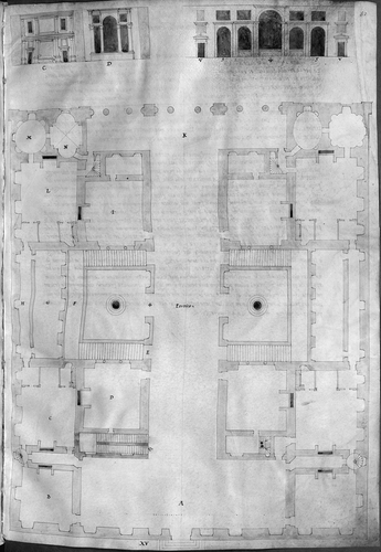
The portego, then, was by far the most important room for the display of maps on walls. Much as in da Porto's description of his visit to Sanudo's home, the portego was ‘the spine of the house’, literally in an architectural sense, and also figuratively. As shown in Sebastian Serlio's floor plan of a palace for a Venetian gentleman, the portego connected the front and back of the house, opening onto several rooms that were only accessible through it ().Footnote 22 It was thus the most public space in the house, used, as Vincenzo Scamozzi wrote in his architectural treatise, ‘to receive relatives at the time of weddings, and to have banquets, and celebrations’.Footnote 23
Fig. 1. Sebastiano Serlio, ‘Sesto libro d'architettura’, 1547–1550, a treatise that circulated in manuscript, includes this floor plan of a palace for a Venetian gentleman. Here, the portego, which runs the full length of the house, is the central focus of the palazzo; several rooms are accessible only from the portego. (Reproduced with permission from the Bayerische Staatsbibliothek, Munich, Codex Icon. 189, fol. 52r.)
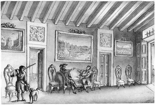
In day-to-day life, the portego was the first place a visitor would see after ascending the staircase to the piano nobile. Patricia Fortini Brown points out that it often intersected with an open colonnaded room called the sala, such as those that form the facade of many of the palazzi on the Grand Canal, leading her to classify the portego as a ‘semi-public’ space because of its visibility from outside.Footnote 24 She also observes that ‘the head of the house might receive business clients [here] who would not be invited into the more private rooms’ ().Footnote 25 Francesco Sansovino reinforces this interpretation in his statement that ‘the windows of the sala [the room at the end of the portego] are placed in the middle of the façade so that onlookers can easily recognize where the sala is located’.Footnote 26
Fig. 2. Interior Scene with Two Gentlemen Seated in a Hall Hung with Venetian Paintings, A Hunter and His Dog Standing to the Left. North Italian School from the eighteenth century. Oil on canvas. On the walls of this room, most likely a sala or portego, are views of Venice at Carnival time after Canaletto. (Private collection. Image reproduced courtesy of Sotheby's.)
Advice on Displaying Maps
Da Porto's epigram praised Sanudo personally for his decorating acumen, but da Porto's comments applied to everybody. Literate Venetians would have had access to advice on the best way of arranging maps in their houses from a variety of sources. Most of these were printed, but, like da Porto's poem, an occasional treatise circulated in manuscript. A late example of the latter was a text on the display of art by Guilio Mancini (1558–1630), a Sienese doctor, which clearly articulates the placement of maps within the home. His ‘Considerazioni sulla pittura’, written in 1619, was widely copied and distributed. This manuscript was an expansion of an earlier, shorter work titled ‘Discorso di pittura’, written in 1617. In both Mancini gave a brief explanation of the history of art along with advice for collectors.
Mancini's advice to collectors was to arrange the paintings in their homes according to subject matter. He went through a list of different types of art, from religious works to classical, from paintings of war to nude women, explaining where in the home a collector should locate each category. He also recommended how to deal with maps, suggesting that ‘landscapes and cosmographies’ should be positioned ‘in the galleries where everyone can go’.Footnote 27 In his earlier manuscript Mancini had similarly argued that maps should be highly visible: ‘landscapes, pastorals, animals, seasons of the year and similar works should be placed in communal galleries and porticos and where everyone can frequent, this is also where perspectival scenes and cosmographies should be placed’.Footnote 28
The placement of art within the home shapes how others will view the collector, as Mancini understood. A collector should aim to ‘impress’ visitors with the different genres on his walls, making sure to choose their locations according to the function of each room and the appropriateness of the images for public viewing or private contemplation. Religious art should go on the ground floor and in rooms where people sleep; depictions of war and other civil actions should be in the antechambers or halls along with images of popes, cardinals, emperors and other princes so that visitors would be impressed; lascivious paintings of Venus, Mars and nudes should be in galleries in the garden or in private rooms ().Footnote 29
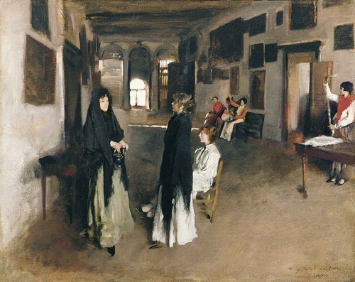
Plate 1. John Singer Sargent's A Venetian Interior, c.1880–1882 (oil on canvas), captures both the architectural and design elements of the Venetian portego. As the household inventories of the sixteenth century indicate, the portego was richly decorated with paintings and prints centuries before Sargent's portrayal. (Held by the Sterling & Francine Clark Art Institute, Williamstown, Massachusetts. Reproduced with permission from The Bridgeman Art Library International.)
In Mancini's logic, maps belonged in the most public spaces in the home, where they would be seen and thus would reflect positively upon the owner. A similar sentiment had been promoted by the Florentine architect and humanist Leon Battista Alberti nearly two centuries earlier. On the Art of Building, written around 1450 and the first book on architecture since antiquity, dedicates Book 9 to advice on the decoration of private homes. Alberti remarked that ‘it is surely most appropriate for a portico or a dining hall to be painted or sculpted with scenes of bravery by the citizens, portraits and events worthy of recollection’. He went on, ‘We are particularly delighted when we see paintings of pleasant landscapes or harbors, scenes of fishing, hunting, bathing, or country sports, and flowery and leafy views’.Footnote 30
It is scarcely conceivable that Mancini had not read Alberti's text. Both stress that certain types of images are most suited to the public spaces within a home; landscapes are one of these types. However, there is a recognizable difference between the language used by Alberti and by Mancini, largely because in the centuries separating the two authors, the number of maps circulating in Europe increased dramatically.Footnote 31 Alberti's hypothetical fifteenth-century home designer lived in a world of limited private map ownership—a mere 1,500 maps were created in the five centuries before the advent of printing—and would have been more familiar with the artistic depictions of landscapes and harbours than with the cosmographies mentioned by Mancini.Footnote 32
The value of maps was also touched on in Baldassarre Castiglione's The Courtier [1528], another text that many Renaissance Venetians were likely to have read. Sounding much like da Porto in his epigram for Sanudo, Castiglione makes his count say:
The machine of the universe, which we can see in the vast spaces of heaven, so resplendent with their shining stars, in the earth at its centre, surrounded by the seas, varied with mountains, valleys and rivers … can be said to be a noble and grand painting, composed by nature and the hand of God. And, in my opinion, whoever can imitate it deserves the highest praise.Footnote 33
Just as da Porto claimed that a world map opened ‘the immeasurable machine of the universe’ and made him ‘understand the sea, the earth, and the vast world’, Castiglione claimed that the purpose of painting was to capture the ‘machine of the universe’.Footnote 34
Of course, in The CourtierCastiglione was writing about the skills that an educated nobleman should have, one of which was painting. This was partly for military reasons, since ‘a knowledge of the art gives one the facility to sketch towns, rivers, bridges, citadels, fortresses and similar things’, skills very similar to those needed by a mapmaker.Footnote 35 Castiglione also mentioned another reason for collecting art, namely that ‘a knowledge of painting is the source of very profound pleasure’.Footnote 36 The dual functions ascribed to painting—the representation of the contours of the landscape and the provision of aesthetic pleasure—can, by extension, also apply to cartography. And although cartography was not Castiglione's direct concern, he was an appreciator of maps, owning at least one himself.Footnote 37
Marcantonio Michiel (1484–1552), who wrote ‘Notizia d'opere del disegno’ between 1521 and 1543, spoke about the importance of the home as a site for showing art work. These notes, circulated in manuscript but unpublished until 1800, represent his survey of the important art works in various cities in northern Italy, including Padua, Cremona, Milan and Pavia. Whereas for these cities he focused on art work in churches and public art, his section on Venice is firmly situated in the private home.Footnote 38 Michiel must have gone from house to house listing the art works in great detail and often noting their location. Thus, Andrea di Oddoni had a crystal bowl engraved in the hand of Christophoro Roman, M. Chabreil Vendramin owned ‘a chiaroscuro in ink, made by the hand of Rafael’, and Cardinal Domenico Grimani possessed, among his ‘many images of saints’, ‘many small tablets of landscapes for the most part in the hand of Alberto of Holland’.Footnote 39
Michiel's work reinforces the idea that Venetians both knew and cared about what was in their neighbours' homes, and that they wanted their neighbours to know what was in theirs. In the early years of the sixteenth century when the collection of art and marvels was still in its early stages, these men turned their houses into galleries that they organized with a purpose—to demonstrate their knowledge and reinforce their identities (). Maps were part of this effort and were particularly valued for their flexibility in conveying multiple messages.
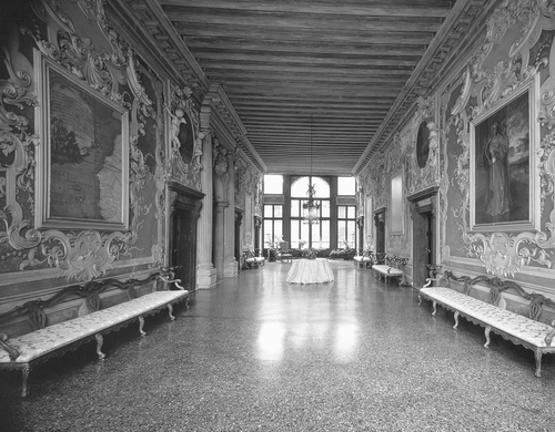
Fig. 3. Interior view of the salon from Ca' Da Mosto in Venice showing the richly decorated seventeenth-century style portego facing the sala on the Grand Canal. The map on the left shows northwest Africa and the Atlantic Ocean. The palace, built in the thirteenth century and the oldest on the Grand Canal, is named after the Venetian explorer Alvise Ca' da Mosto, who travelled the coast of Africa in the mid-fifteenth century under the aegis of Prince Henry of Portugal. (Reproduced with permission from the Scala / Art Resource, New York.)
The Display of Maps in Venetian Homes
In order to reconstruct the interior spaces of Venetian homes, I compiled complete or partial (excluding moveable furnishings) lists of images for more than fifty porteghi containing maps. An analysis of the way the images were coupled with maps indicates that the maps were valued as signifiers of their owner's status. Their versatility served him in multiple ways, conveying to all that here was a cultured, cosmopolitan man, informed, well-connected in the commercial world and professionally skilled, and evoking his or his antecedents' military standing. They glorified the family name.
The following case studies were selected according to several criteria. First, I largely chose examples where I could collect supplementary information about the individual or family represented in the inventory. In some instances this amounted solely to the description of the individual's profession given in the inventory, whereas for others, such as Marco Dandolo and Marietta Pisani, much is known about their family history. My selections thus tend towards the wealthier map owners, in part because they allow for a richer picture of the map's role in shaping identity, but also because the less well-off map owners frequently possessed fewer images. My second criterion required inventories that contained a large number of maps along with other images, again in order to provide a more detailed and complex reading of the map's place in the portego.
That there was a close association between the maps and the owner's identity is made particularly clear when we look at the images surrounding maps in the porteghi of individual Venetian households. Andrea Maioli, whom the notaries listing his goods in 1571 identified as a cavaliere, had chosen to emphasize his military background. In his portego were maps and images from the Netherlands, which could be taken to indicate his service there during the ongoing revolt against Spanish rule. If so, his home decor promotes the Spanish cause; for his portego contained a map of the duchy of Brabant, at the time ruled by Philip II of Spain, along with a number of views of cities, on which the Imperial arms were shown in gold.Footnote 40
In addition to Brabant, Maioli's portego contained maps of Gelderland, Holland, Amsterdam, Bruges and Flanders, which he might have used to follow events in the first decade of what is now called the Eighty Years' War.Footnote 41 In the course of the sixteenth century the circulation of news in print was accelerating, and accounts of events were increasingly illustrated by maps and views. In the case of the siege of Malta (1565), for example, Niccolò Nelli's prints began to be distributed within a month of the siege and were updated several times between May and August of 1565, capitalizing on the desire among Italians for news of the Ottoman fleet.Footnote 42
At the same time, Maioli's collection reinforced his interest and expertise in military matters, as is seen from the decoration of his second home. Here, in the portego, Maioli had ‘an image of diverse armies’, another of two Flemish armies, and a map of Europe.Footnote 43 Maioli also had portraits of Emperor Charles V and Johanna Queen of Spain, and in a separate room he had images of the funeral of Charles V, and a map of the city of Colonna.Footnote 44
If Maioli's maps spoke mainly to his military career, other Venetians used maps to strengthen their professional associations. The maps on the walls in the home of Gasparo Segezi, a miniaturist whose household contents were recorded in 1576, reveal a distinctly classical bent. In a room off the portego Segezi had either prints or paintings of an ancient Greek Madonna, a nude woman, the Roman emperors Caesar Augustus and Hadrian, along with ‘an image of an old map’.Footnote 45 The description of the map does not reveal if this was an old map or a map of the classical world. In either case, the contents of the room would have indicated Segezi's interest in the classical past, and the map amplified this impression.
To judge by his wall decorations, Segezi was a humanist. The art in his portego, where there was another classical emperor as well as two more old madonnas and a portrait of Segezi himself, also pointed to his interest in antiquity.Footnote 46 Through the art on the walls of his home, Segezi was proclaiming that he was knowledgeable about the classical past. The inclusion of a self-portrait was not only a form of self-fashioning, but also an advertisement of his skills as an artist and miniaturist. Segezi wanted his patrons to know that he was both competent and cultured, knowledgeable in the classics.
Another man whose house became almost an advertisement for his services was Bernaba di Rizzi, who lived in the parish of San Felice, near San Marco, and died in 1609. Di Rizzi was a sanser, or broker, most likely dealing in wholesale goods, for whom it would have been important to maintain a reputation for having many connections, not only for business reasons, but also to ensure he always had the latest news. His portego contained portraits of several rulers, including the kings of Spain and France and the pope.Footnote 47 Next to these powerful men he had a map of Transylvania, possibly to indicate his trading ties with Hungary and the Ottoman Empire. The combination of his portraits of great rulers and the map would have reinforced di Rizzi's claim to having many valuable ties abroad.
Maps were also frequently coupled with religious images, as in the porteghi of Cornelia Bellon and Bernardin Serena. The only items listed in the 1538 inventory of Bellon's portego, apart from a map of Italy, were the adjacent pictures of Mary, mother of Christ (stamped with the family arms), and Christ himself.Footnote 48 Later in the century, in 1584, we find a similar arrangement in Serena's portego, where there were pictures of Mary and of the Last Supper next to doi quadri de paesi de Tuscana [two pictures of the Tuscan countryside], together with, elsewhere in the room, a painting of Mary Magdalene and portraits of Serena's parents.Footnote 49
For both Bellon and Serena, the maps were prominent in small collections of the primarily religious images that tended to be omnipresent in Venetian homes.Footnote 50 It is difficult, accordingly, to know how to interpret their collections. It could be that the juxtaposition of geographical and religious representation was coincidental. Alternatively, it could be that the combination of just a few religious pictures with an even smaller number of maps or landscapes was intended to highlight a devout family's interest in, or loyalty to, the locations depicted. In Serena's case the genealogical elements in the room combined with the landscapes could indicate that his family was from Tuscany; for Bellon, the flanking the map of Italy with pictures of Mary and Jesus could suggest a plea for the protection of the Holy Family for the war-torn continent.Footnote 51
The wall decorations in Marietta Pisani's house, as detailed in 1623, are more difficult to categorize. The inventory lists them together without delineating location. In spite of this, the collection is revealing. Out of a total of 67 pictures, 25 were of religious subjects, including 13 madonnas. There were also representations of the Three Wise Men, Christ, Mary Magdalene and Saint Francis. In addition, Pisani had two images of senators (possibly Roman or Venetian), one each of the king of France and an unspecified prince, and a sketch of a general. She also had seven maps.Footnote 52
In contrast to the lack of information about their location in the house, the map entries in Pisani's inventory are relatively detailed. One map is described as an ‘image of the Geography of all of the world’.Footnote 53 Alongside this map were ‘images of the four parts of the world’, meaning individual maps of Europe, Asia, Africa and America in accordance with the fashion that had grown in popularity during the sixteenth century.Footnote 54 The presence of a set of ‘modern’ maps hint at the contemporary shift away from classical knowledge towards contemporary geography. There were also several landscapes described as a quadretto con un paese [countryside] and two telari[framed images] di paesi. These may have been landscapes in the style recently popularized by the Flemish, or they may have depicted specific regions. The inventory also listed a quadro con il disegno della citta di Verona, where Pisani's ancestors had served as podestà in the fifteenth century, which would have been both a reminder of the family's power and of the recently built Pisani villa in Verona.Footnote 55
Whereas the Pisani household appears to have had a taste for a wide spread of visual subjects consistent with the general idea of a ‘Renaissance home’, in another home the focus was explicitly on maps as a means of advertising the family's standing in the community. When an inventory was made in 1631 of Marco Dandolo's home, his rooms revealed a particular interest in city maps. There were maps of Buda, Rome and Padua. Next to these, following ‘an old parchment with a description of other territories drawn in pen’, came a printed map of Bergamo.Footnote 56 The same room contained ‘two printed maps in large folio one a sketch of Friuli and the other of the Duchy of Carniola’.Footnote 57 Dandolo also had something not encountered anywhere else in the Venetian inventories: a ‘drawing [disegno] in paper attached to cloth of Piran and territory’.Footnote 58
Piran, on the Istrian peninsula, had been under Venetian control since 1282. This map was perhaps intended to indicate Dandolo's trading interests with either just the town or with the region as a whole. Moreover, since Dandolo came from a politically involved family that had produced four doges and numerous regional governors in the Terrafirma, the map of Piran, taken together with those of Rome and Buda as well as more local places such as Bergamo and Padua, suggests that his collection was intended to underline his personal connections with the world as controlled by or aligned with Venice as well as Venice's supremacy.
This interpretation is reinforced by yet another drawing, ‘painted with the arms of the Dandolo family’, of the fortress in Bergamo.Footnote 59 Dandolo would have had good reason to stamp Bergamo with the family's bearings for when, in 1437, his ancestor and namesake, Marco Dandolo, had served as Venetian ambassador to the Holy Roman Empire (and stood as representative for the Republic), the Empire had officially recognized Venice's claim to Bergamo, along with Padua, Treviso, Brescia and other parts of Venice's Terrafirma. Similarly, another of Marco's illustrious ancestors, Giovanni Dandolo, had served as podestà of Padua in the late thirteenth century and as doge had signed the treaty which brought Piran under Venetian control.Footnote 60 By the early seventeenth century, thus, the historically important Dandolo family had a strong claim—as demonstrated in the maps decorating their house in Venice—to close ties with the territory of Bergamo, the city of Padua, and the territory around Piran.
Dandolo was neither the first nor the only Venetian to draw attention to his or his family's connections with a particular province or region through the maps decorating their homes. In Marino Sanudo's portego, with its map of the world that Federico da Porto had found so enlightening, there had also been a view of Verona where Sanudo had once held a minor administrative position for sixteen months early in his career.Footnote 61
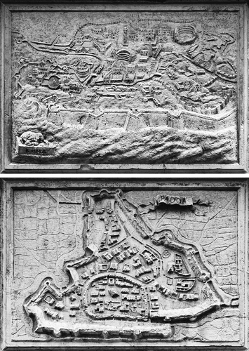
The practice apparently continued well into the seventeenth century. When, in 1626, the contents of Marco Crasso's house were recorded, the Officers found this cittadino veneto [citizen of Venice] had portraits of himself, his famous jurist brother Nicolo, and another relative named Alvise Crasso along with a map of Rome and two world maps.Footnote 62 Much later in the seventeenth century, Admiral Antonio Barbaro requested in his will of 1678 that the façade the church of Santa Maria del Giglio be carved with maps of the six cities in which he had served: Padua, Candia [Heraklion, Crete], Zara, Rome, Spalato [Split, Croatia] and Corfu (). These maps took the formerly private glorification of an individual through maps and turned it into a public testament to the naval and political glory of the family.Footnote 63
Fig. 4. The façade of Santa Maria del Giglio in Venice has six relief maps carved between 1679 and 1683 under the direction of Giuseppe Sardi. Shown here are those of (top) Rome and (bottom) Padua. The maps were requested by Antonio Barbaro as part of the larger effort to glorify his family's history. (Photography by Steve Carlton.)
The household inventories described here have illuminated a perhaps unexpected aspect of sixteenth- and early seventeenth-century Venetian domestic life. Venetians evidently greatly appreciated maps as wall decoration in their homes, in both public and private rooms. Whereas, however, it might have been anticipated that their tastes would run towards images of the city they were so proud to live in, precisely the opposite is found. Hardly any households had either a map or a view of their own city.
Venetians had many reasons for choosing the maps they placed, with other pictures, on their walls. Sometimes their concern was domestic; to promote the reputation of the householder, for example. At other times, it was their social standing that had encouraged a selection of maps that glorified Venice and celebrated her territorial and commercial power. This was especially the case where members of the family, or their ancestors, had been involved in strengthening Venice's empire. Whatever each particular reason, Venetians saw their maps as consumer objects, which they valued not merely in monetary terms, or even for geographical information, but for the subtle messages they conveyed to their neighbours and visitors. In Renaissance Venice, maps were self-fashioning agents that operated through association. In this respect, their maps were no different from those in the great halls of state in other parts of Italy, and elsewhere. In Venice, however, the maps carried more intimate connotations when displayed in the family home.
This article is based on a talk given on 14 June 2010 in the British Library's symposium ‘Maps in Context’.
Notes
NOTES AND REFERENCES
1. Venice, Biblioteca Marciana [hereafter BM], It. cl. XII, cod. 211, cited in Rinaldo Fulin, ‘Diarii e diaristi veneziani’, Archivio Veneto 22:1 (1881): xx: ‘Inde jubes scalam paulatim ascendere’ sursum / Tendimus: in summo porticus ampla patet. / Hicque novum intramus rerum mare; cernitur usquam / Nex paries: quavis parte nihil vacuum. / Hic poteris varias hominum spectare figuras, / Deformes facies; hic nova mille vides’. This is also discussed in Federica Ambrosini, ‘Descrittioni del mondo nelle case venete dei secoli XVI e XVII’, Archivio Veneto 117 (1981): 67–68; and in Patricia Fortini Brown, Private Lives in Renaissance Venice: Art, Architecture, and the Family (New Haven, Yale University Press, 2004), 222–23.
2. The word portego was commonly used for a roofed outdoor space supported by a colonnade, but in Venice it usually designated an entrance hall on the piano nobile reached by a long flight of stairs inside the home.
3. BM It. cl. XII, cod. 211, cited in Fulin, ‘Diarii e diaristi veneziani’ (see note 1): ‘Immensi tandem reseratur machina mundi … [xx]. Vidi quae continent orbis, / Quae mare, quae caelum, tartara et antipodes … Qui mare, qui terram et vastum vult cernere mundum, / Ille domum aspiciat, docte Marine, tuam’ [xix].
4. It is worth noting that da Porto knew how to read a map, an acquired skill which was likely shared by most educated Italians in the sixteenth century. At least 10 per cent of Venetian households, and possibly more, then had maps, a proportion that remained steady throughout the 140 years covered by the inventories. Since the absolute number of inventories grew faster than total population, the implication is that the number of Venetian households containing maps was also increasing. Maps, it is clear, were not obscure objects, but liable to be encountered by a Venetian on a regular basis.
5. On map publishing in Venice, see David Woodward, ‘The Italian map trade, 1480–1650’, in The History of Cartography, vol. 3: Cartography in the European Renaissance, ed. David Woodward (Chicago, University of Chicago Press, 2007), 779–91; Denis Cosgrove, ‘Mapping new worlds: culture and cartography in sixteenth-century Venice’, Imago Mundi 44 (1992): 65–89; Lilian Armstrong, ‘Benedetto Bordon, ‘miniator’, and cartography in early sixteenth-century Venice’, Imago Mundi 48 (1996): 65–92. For more on map collecting and display, see George Tolias, ‘Maps in Renaissance libraries and collections’, in Woodward, Cartography in the European Renaissance, op. cit., 637–60; David Woodward, Maps as Prints in the Italian Renaissance: Makers, Distributors & Consumers (London, British Library, 1996), particularly chapter 3 on the consumers of maps. On the display of maps in the halls of government, see Francesca Fiorani, The Marvel of Maps: Art, Cartography and Politics in Renaissance Italy (New Haven, Yale University Press, 2005), and idem, ‘Cycles of painted maps in the Renaissance’, in Woodward, Cartography in the European Renaissance, op cit., 804–30. On collecting in Italy more broadly, see Krysztof Pomian, Collectors and Curiosities: Paris and Venice 1500–1800 (Cambridge, Polity Press, 1990); and Paula Findlen, Possessing Nature: Museums, Collecting and Scientific Culture in Early Modern Italy (Berkeley, University of California Press, 1994).
6. Woodward, ‘The Italian map trade, 1480–1650’ (see note 5), 794.
7. In the history of cartography, see Catherine Delano-Smith, ‘Map ownership in sixteenth-century Cambridge: the evidence of probate inventories’, Imago Mundi 47 (1995): 67–93; and Ambrosini, ‘Descrittioni del mondo’ (see note 1). For non-cartographic studies, see Margaret A. Morse, ‘Creating sacred space: the religious visual culture of the Renaissance Venetian casa’, Renaissance Studies 21:2 (2007): 151–84; and John Kent Lydecker, ‘The Domestic Setting of the Arts in Renaissance Florence’ (doctoral dissertation, Baltimore, MD, The Johns Hopkins University, 1987).
8. Both offices collected inventories in cases where an individual died without an heir or with a minor heir; their records also contain wills, testaments and inventories of disputed estates.
9. This figure almost certainly represents an undercount, since many inventories did not list the wall decorations individually or give the titles of the books.
10. Genevieve Carlton, ‘Worldly Consumers: The Demand for Maps in Renaissance Italy’ (doctoral dissertation, Evanston, IL, Northwestern University, 2011), particularly chapter 5. Rather than separate landscape maps from other types of maps, I treat them as manifestations of the same cartographic impulse. The demand for landscapes as consumer objects was driven by the desire to purchase images of specific places. Even when the landscapes are of unspecified locations, they nevertheless indicate an interest in capturing and recreating the outside world within the home.
11. The lack of a terminological distinction between a cartographic and any other image on display provides further evidence that for sixteenth-century viewers there was not a substantial gulf between maps and what are regarded today as ‘works of art’.
12. State rulers also understood the power of maps as public objects, as evident through the numerous mural maps commissioned during the 16th century. While these civic murals have usually been interpreted as evidence of the imperial, land-claiming nature of maps, they also point to the symbolic and cultural messages in maps. On the use of maps at this level for similar purposes, see Fiorani, The Marvel of Maps (note 5), and Fiorani, ‘Cycles of painted maps in the Renaissance’ (note 5).
13. In the whole of my survey, I found only two references to maps of Venice, one of which was owned by a Genoese merchant. The inventory records listing these maps are in the Archivio di Stato Venezia, Giudici de Petizion [hereafter ASV, GdP], b. 349/14, no. 72, 1625 Nov., fol. 1r.; and ASV, GdP, b. 348/13, no. 20, 1622 June 6, fol. 12r. The absence of local views was also noted by Woodward, who remarked on a lack of representations of Saint Mark, the patron saint of Venice, in the inventories: Woodward, Maps as Prints (see note 5), 83.
14. Sara F. Matthews-Grieco, ‘The buyers’ end of the market: demand, taste and consumption in Renaissance and Counter-Reformation Italy’, in The Art Market in Italy: 15th–17th Centuries, ed. Louisa Matthew, Sara F. Matthews-Grieco and Marcello Fantoni (Modena, Panini, 2003), 19.
15. Delano-Smith, ‘Map ownership in sixteenth-century Cambridge’ (see note 7), 67.
16. Ibid., 71.
17. Ambrosini, ‘Descrittioni del mondo’ (see note 1), 78–79.
18. Morse, ‘Creating sacred space’ (see note 7), 158–59.
19. Ibid., 177.
20. Marino Sanudo, I diarii di Marino Sanuto, 58 vols. (Bologna, Forni Editore, 1969), vol. 13, col. 293; 5 Dec. 1511: ‘Da poi disnar, noto, el signor Alberto da Carpi vene a veder il mio studio e il mapamondo insieme con tre savii ai ordeni sier Alvise Bembo, sier Mafio Lio, sier Daniel Barbarigo’. On the Italian studiolo, see Dora Thornton, The Scholar in His Study: Ownership and Experience in Renaissance Italy (New Haven, Yale University Press, 1997); and Tolias, ‘Maps in Renaissance libraries and collections’ (see note 5).
21. ASV, GdP (see note 13), b. 345/10, no. 91, 1614 Feb. 27, fol. 7v.; ASV, GdP (see note 13), b. 348/13, no. 24, 1622 Oct. 31, fol. 6r.; Archivio di Stato Venezia, Cancelleria Inferiore, Miscellanea Notai Diversi, [hereafter ASV, MND], b. 43, no. 16, 1590 Feb. 8, fol. 2r.
22. Sebastiano Serlio, floor plan of a palace for a Venetian gentleman, in his ‘Sesto libro d'architettura’, 1547–1550 (Munich, Bayerische Staatsbibliothek, Codex Icon. 189, fol. 52r).
23. Vincenzo Scamozzi, L'idea della architettura universale (Venice, Expensis Auctoris, 1615), 243: ‘per potere ricevere i parentadi nel tempo delle nozze, e far conviti, e feste’. Cited in Brown, Private Lives in Renaissance Venice (see note 1), 71; for more on the portego, see 71–75.
24. Brown, Private Lives in Renaissance Venice (see note 1), 74–75.
25. Ibid.
26. Francesco Sansovino, Venetia citta nobilissima (Venice, 1581; reprinted Farnborough, Gregg, 1968), 1: 384: ‘si mettono le finestre della Sala nel mezzo della facciata, onde si comprende con facilità da i riguardanti, dove sia posta la Sala’, cited in Brown, Private Lives in Renaissance Venice (see note 1), 74.
27. Giulio Mancini, Considerazioni sulla pittura [1619] (Rome, Accademia nazionale dei Lincei, 1956), 143: ‘per i paesaggi e cosmografie si metteranno nelle gallarie e dove puol andar ognuno’. The 1956 Lincei edition includes both the 1617 and 1619 texts.
28. Ibid., 331: ‘paesacci, pastori, animali, stagion d'anno e simili si metteranno nell gallerie comuni e portici e dove ognuno possa praticare, dove ancor si possin mettere le prospettive, cosmografie’.
29. Ibid., 143–44.
30. Leon Battista Alberti, On the Art of Building in Ten Books [c.1450] (Cambridge, Mass.: MIT Press, 1988), 299, Bk. 9.4.
31. Robert Karrow estimates that some 60,000 individual maps were in circulation in the year 1500, a figure that rose to approximately 1.3 million by 1600, causing ‘a sea change in European consciousness of the possibilities of maps’. Robert W. Karrow, ‘Centers of map publishing in Europe, 1472–1600’, in Woodward, Cartography in the European Renaissance (see note 5), 611–21, at 621.
32. For this figure see the table in J. B. Harley and David Woodward, eds., The History of Cartography, vol. 1: Cartography in Prehistoric, Ancient, and Medieval Europe and the Mediterranean(Chicago, University of Chicago Press, 1987), 298 n.15; and Robert W. Karrow, ‘Intellectual Foundations of the Cartographic Revolution’ (doctoral dissertation, Loyola University of Chicago, 1999), 7.
33. Baldassarre Castiglione, Il Cortegiano [1528], ed. Carlo Baudi di Vesme (Firenze, F. Le Monnier, 1854), 65: ‘Chè la machina del mondo, che noi veggiamo coll'amplo cielo di chiare stelle tanto splendido, e nel mezzo la terra dai mari cienta, di monti, valli e fiumi variata, e di si diversi alberi e vaghi fiori e d'erbe ornata, dir si può che una nobile e grand pittura sia, per man della natura e di Dio composta; la qual chi può imitare, parmi esser di gran laude degno’.
34. BM It. cl. XII, cod. 211, cited by Fulin, ‘Diarii e diaristi veneziani’ (see note 1): ‘Immensi tandem reseratur machina mundi … ’[xx]; ‘Qui mare, qui terram et vastum vult cernere mundum, / Ille domum aspiciat, docte Marine, tuam’ [xix].
35. Castiglione, Il Cortegiano (see note 33), 65: ‘della [arte], oltra che in sè nobilissima e degna sia, si traggon molte ultilità, e massimamente nella guerra, per disegnar paesi, siti, fiumi, ponti, ròcche, fortezze, e tai cose’.
36. Ibid., 68: ‘Vedete adunque come lo aver cognizione della pittura sia causa di grandissimo piacere’.
37. Emperor Charles V had given Castiglione a manuscript map made by Diego Ribiero: see Peter Barber and Tom Harper, Magnificent Maps; Power, Propaganda and Art (London, British Library, 2010), 119–20; and Guido Rebecchini, Private Collectors in Mantua 1500–1630 (Rome, Edizioni di storia e letteratura, 2002), 119.
38. Marcantonio Michiel, Notizia d'opere del disegno [c.1532], ed. Cristina De Benedictis (Florence, Edifir-Edizioni Firenze, 2000).
39. Ibid., 52, 56, 58. The identity of Alberto of Holland is unknown.
40. ASV, MND (see note 21), b. 41, no. 46, 1571 April 9, fol. 1v.
41. The identity of these maps is uncertain, but, in view of their dates and descriptions they were probably those printed by Paolo Forlani, who had produced maps of Brabant (1566), Holland (1563) and Flanders (1567). It is quite possible that the maps of Gelderland, Bruges and Amsterdam were also made locally in Venice, which published more maps in the 16th century than any other city.
42. Woodward, Maps as Prints (see note 5), 93–99. See also Alberto Ganado and Maurice Agius-Vadalà, A Study in Depth of 143 Maps Representing the Great Siege of Malta of 1565, 2 vols. (Valletta, Malta, Publishers Enterprise Group, 1994).
43. ASV, MND, b. 41, no. 46, 1571 April 9 (see note 40), fol. 7v.
44. Ibid., fols. 7v–8r. Probably a map of Cologne, Germany, but it could have been a representation of Colonna, Lazio, Italy.
45. ASV, MND (see note 21), b. 42, no. 32, 1576, May 15, fol. 1v. The text reads ‘un quadro di napamondo [sic] vecchio’.
46. Ibid., fol. 1r.
47. ASV, GdP (see note 13), b. 344/9, no. 10, 1609 Oct. 6–13, fol. 11r. Rizzi's portego also contained a collection of four images portraying each season of the year. These ‘quadri delle stagioni del anno’ were popular among Venetian households in the 16th and early 17th centuries.
48. ASV, MND (see note 21), b. 34, no. 51, 1538 May 4–8, fol. 2r.
49. ASV, GdP (see note 13), b. 338/3, no. 58, 1584 Sept. 19, fol. 7v.
50. Morse, ‘Creating sacred space’ (see note 7), 158–59.
51. For the cartographic images distributed to Italian pilgrims showing the territory protected by the local madonna or saint, see Catherine Delano-Smith and Alessandro Scafi, ‘Sacred geography’, in Szent Helyek a Térkeépeken / Sacred Places on Maps, ed. Zsolt Török (Pannaonhalma, Hungary, Archabbey of Pannonhalma, 2005), 122–40, figs. on 51.
52. ASV, GdP (see note 13), b. 348/13, no. 65, 1623 June 12, fol. 4r.
53. Ibid., fol. 4r: ‘quadro con la Geografia di tutto il mondo’.
54. Ibid., fol. 4r: ‘quadri con le quattro parti del mondo––no.4’. For more, see Ambrosini, ‘Descrittioni del mondo’ (note 1). See also Mariarosa Cesari, ‘New evidence for the date of five rare Dutch-Italian wall maps: F. de Wit's world map and W. J. Blaeu's four continents’, Imago Mundi, 64:1 (2012): 41–59.
55. ASV, GdP (see note 13), b. 348/13, no. 65, 1623 June 12, fol. 4r. Podestà was the Italian term for an elected governor, often a foreigner, who would rule a city-state for a period of between six months and two years. The practice, common from the 12th to 16th centuries, was partly an attempt to quash local factionalism.
56. ASV, GdP (see note 13), b. 352/17, no. 99, 1631 April 29, fol. 7v: ‘una bergamina vechia scritta a pena con descrittione de altri territori’.
57. Ibid., fol. 7v: ‘doi carte in foglio real stampate cioe una della descritione del friul et l'altra del Ducado di Carniola’. Carniola, today part of Slovenia, was then part of the Austrian Empire. Folio here refers to the size of the paper; when objects were found in cupboards or drawers the notaries recorded the location; these maps were all listed together as simply in the room.
58. Ibid., fol. 7v: ‘dissegno in carta attacato in tella di Piran et territorio’.
59. Ibid., fol. 31r: ‘un dissegno della fortezza di Bergamo colorito con l'arma Dandola’.
60. Emmanuele Cicogna, Giovanni Veludo, Francesco Caffi, Giovanni Casoni, Giovanni Antonio Moschini and Antonio Nani, Storia dei dogi di Venezia (Venice, G. Grimaldo, 1867), number 48.
61. BM, Ital. cl. IX, cod. 364, cited in Fulin, ‘Diarii e diaristi veneziani’ (see note 1), xxi. See also D. S. Chambers, ‘Marin Sanudo, Camerlengo of Verona, 1501–1502’, Archivio Veneto 109 (1977): 37–66.
62. ASV, GdP (see note 13), b. 350/15, no. 16, 1626 April 27, fol. 2r.
63. For more, see Deborah Howard and Sarah Quill, The Architectural History of Venice (New Haven, Yale University Press, 2002), 229–31.