Abstract
This paper presents a methodology for the use of 3D modelling and landscape visualization in the context of real-world experience. The techniques offer a framework for a qualitative ‘ground truth’ exercise to assess the nature and quality of digital geographic information within the context of fieldwork exercises. In view of the increasing use of such compelling images in a range of public contexts, the approach aims to encourage viewers of computer-generated landscape images to question the data and processing techniques which generated the digital models. The techniques are used to complement the physical geography components of fieldwork by augmenting real scenes with hidden (geological) and past (glaciated) landscapes. Ongoing developments in the use of mobile computing devices to further support these approaches are presented.
Introduction: The Need for ‘Ground Truth’ in Landscape Visualization
The use of digital models of the Earth's surface is widespread and 3D visualization of such data is increasingly common in the public domain. There are also increasing expectations of what is possible, in part driven by the computer games industry but also by the growing popularity of so-called ‘virtual globes’ such as Google Earth and Microsoft's Virtual Earth 3D. Although visualizations are ever more compelling and believable there is a risk that many audiences are totally unfamiliar with the nature of the digital data and processes used to build such models. This danger can be recognized in the context of environmental decision-making where rural landscapes are often visualized as part of public consultations (Appleton & Lovett, Citation2003).
Many techniques for the creation of digital models and potential pitfalls in their use have been well documented in the academic literature (Lane et al., Citation1998). Data sources for elevation include direct ground survey, contours and spot heights, photogrammetry, airborne laser measurement known as Light Detection And Ranging (LiDAR) and Interferometric Synthetic Aperture Radar. The distribution and density of elevation data points can vary hugely, yet should be at an appropriate resolution for the task at hand. This concept of ‘fit for purpose’ extends to derivatives of the elevation including slope and water flow used in GIS analysis and also computer-generated landscape visualizations, which can be presented either as static snapshots, animated fly-throughs or real-time interactive virtual environments.
Bishop (Citation1994) observed the increasing use of visual realism when creating landscape visualizations due to the need to involve the public in decision-making, and therefore to present information in a more digestible form. Given cheaper and increasingly more powerful tools this can be done effectively, irrespective of the quality of available data. The addition of high resolution aerial photography draped over the surface is a common technique and offers a familiar representation to most viewers, exploiting their tendency to make sense of visual images (Wood, Citation1994). It may also have the effect of masking crude representations of the terrain containing artefacts of sparsely distributed height data. The high resolutions of the aerial imagery tend to dominate the scene and make it more likely that the audience accepts the 3D view as ‘the truth’.
Figure illustrates this phenomenon, featuring models of Cat Bells, a hill near Keswick in the English Lake District. The view shown in Figure was interpreted by a colleague of the author as showing horizontal geological strata on the hillside left of centre, whereas in fact this banding is a result of contour-related artefacts. The model viewed in Figure is derived from airborne radar and shows down slope linear patterns on the hillside to be dominant. Both surface models are draped with the same high-resolution aerial photography. By replacing the photorealistic drapes with representations of the source height data, contours (Figure ) and a grid of spot heights at 5m spacing (Figure ), the causes of the artefacts become clear, the two surfaces appearing very different. The difference in apparent surface complexity between Figure and Figure is relatively small when compared with clear differences in surface roughness between Figure and Figure , illustrating the power of photographic drapes, especially those containing strong shadowing, to suggest a surface complexity far in excess of that supplied by the elevation data.
Figure 1 Digital representations of Cat Bells, Cumbria, England: (a) contour-derived surface model draped with aerial photography, (b) radar-derived surface model draped with the same photography, (c) contour model showing contour lines, (d) radar model showing data points on a 5 m grid
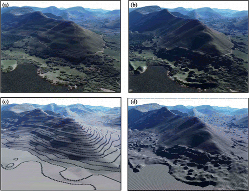
Figure was created by the author for illustrative purposes only and demonstrates how surface models can be created quite easily within a geographical information system (GIS) with ‘default’ settings, using contours at an interval not suitable for the creation of highly detailed surface models. Once photographic drapes are added the metadata describing the nature of the source data and the details of the processing history are often lost.
It is considered important to address these issues within the GIS curriculum by fostering a critical awareness of the nature of various forms of digital surface model. Gillings (Citation2002) noted that realism in virtual reality models is more often judged against photographs than real landscapes, and the same could be said of all forms of landscape visualization. Fieldwork, however, offers an ideal opportunity to design qualitative ground truthing exercises to allow direct comparison of computer-generated scenes with the actual landscapes they represent. Such exercises can also form an engaging introduction to the nature of digital surface models for students in the early stages of a GIS pathway, whilst also supporting learning objectives related to physical geography. Although the focus of the exercise described in this paper is on taking landscape visualization into the field, some of the general utility of the technique is employed before and after fieldwork to support other activities in the spirit of the Virtual Field Course (Dykes et al., Citation1999).
The general premise for this work is that computer-based visualization of landscape is often used to mimic reality in public contexts and therefore we should not only raise awareness of the technical possibilities in various application domains, but also foster a deeper understanding of what could be termed representational fidelity. By focusing on the distinction between ‘believable’ landscape visualization and that which is faithful to reality we can address issues relating to both the techniques and the data used. This work utilizes static snapshots from 3D models to focus on the importance of the data, though other research acknowledges the importance of interactivity in providing a sense of presence in virtual environments (Whitelock & Jelfs, Citation2005).
This paper presents the use of visualization in the context of a real field trip, first by way of support materials when presenting an overview of the physical landscape. The emphasis, however, is on the design of an exercise to specifically engage students in the comparison of landscape visualization and the real scenes. The acquisition of spatial knowledge through fieldwork is considered important for integrating separate observations onto a common frame of reference (Ishikawa & Kastens, Citation2005). By walking through the area to find the locations of chosen viewpoints students have the opportunity to judge the significance of putting static views into their spatial context. The need for careful structuring of experiential learning exercises was recognized by Gibbs (Citation1988) and this is certainly a requirement in the present study where we need to ensure that students reflect on some of the subtleties of data and technique.
Visualization to Support Fieldwork
This paper describes an exercise designed for use on a first-year undergraduate geography field course near Keswick, Cumbria, north-west England. The four-day residential course is a core geography module covering both human and physical geography. Digital data for the area were acquired to support introductions to geology-landscape relationships, the glacial history of the region, and landscape visualization assessment exercises described here. The following data were used:
| • | Digital Surface Model (DSM)—the NEXTMap product, a grid of elevation values at regular 5m spacing, derived from Interferometric Synthetic Aperture Radar. | ||||
| • | Aerial Photography—digital colour aerial photography with a ground resolution of 25 cm. | ||||
| • | Geology—Solid and drift geology data polygons and fault lines. | ||||
In addition a surface model of one possible scenario for the extent of glacial ice and moraine deposits towards the end of the most recent ice age was created through consultation with the geomorphologists on the field course and was constructed using Arcview GIS and the Bryce5 modelling and visualization package.
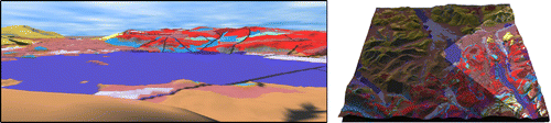
A series of perspective views of the terrain draped with geology (a composite of solid, drift and fault lines) was used in orientation exercises to describe the broad character and history of the landscape. A single panorama from this series is shown in Figure , with the cone of vision highlighted on a block diagram. The radar data were found to be extremely useful for representing the characteristic surface rock structure responsible for some classic Lakeland scenery, for example the rough fault-cut terrain of the Borrowdale volcanics in the south-east quarter of the block diagram.
Figure 2 Geology—landscape relationship: panorama looking East from Cat Bells (left), and the equivalent cone of vision (right)
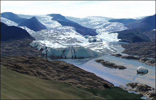
Visualizations of the glacial ice model were rendered in Bryce as static images and printed out to support field-based orientation exercises, an example being shown in Figure . Having used visualization to support the discussion of landscape history and development, a project was designed to engage students with the issues relating to the digital representation of landscape.
Figure 3 Glacial reconstruction in the Newlands Valley: one possible scenario for the retreating glacial ice modelled in Bryce
A Framework for Field-Based Assessment of Landscape Visualization
The aim was to enable students to produce reasonably believable landscape visualizations using commercially available data and then to compare the outputs with their real-world counterparts. No prior knowledge of the software was assumed and the project was designed to take a full day including the written report. Specific learning objectives of the exercise were:
| • | To assess the degree to which individual computer-generated scenes derived from radar terrain data and aerial photography are representative of the real scenes. | ||||
| • | To develop a schema for evaluating such landscape visualization by outlining the factors that proved important when making the comparisons. | ||||
| • | To assess the degree to which evidence observed in the field supports the computer-generated 3D reconstructions of glacial ice retreat. | ||||
| a. | Briefing: Students were organized into groups of four. The concept of a grid-based Digital Surface Model derived from airborne radar was introduced, as was the notion that landscape visualization is often used to represent real scenes in public contexts. | ||||
| b. | Choice of viewpoints: Students were asked to select five locations which they believed would offer a range of landscape scenes suitable for establishing the strengths and weaknesses of the techniques and data for representing real scenes. The locations needed to be easily and safely accessible by foot within a one-hour walk of the field centre. | ||||
| c. | Creation of 3D views: Within the Bryce visualization package each of the chosen viewpoints was taken in turn and the ‘observer’ location and direction were carefully defined. A perspective view was rendered and printed out. In addition the glacial model was merged into the scene and printed out onto acetate to enable a simple ‘augmented reality’ technique to be used. | ||||
| d. | In-field stage: All of the chosen viewpoints were visited in turn in the field assisted by GPS if necessary. The printouts of the computer-generated scenes were annotated, field sketches made as appropriate, and observations made as to the extent to which the image conveyed a true sense of reality (Figures and 4b). In addition to taking digital photos from these viewpoints the groups were encouraged to take spatially referenced photos of other locations in order to re-create these scenes back in the field centre. The printouts of the glacial scene were used to convey the position and extent of one possible scenario for glacial retreat as shown in Figure .
Figure 4 In-field visualization: (a) 3D view from radar model; (b) photo of real scene; (c) simple augmentation technique for views of glacial model 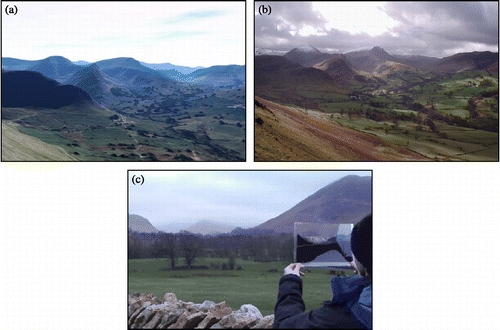 | ||||
| e. | Development of a schema for assessment: The reporting stage back at the field centre first involved some re-creation of scenes to match any additional photos taken in the field. The groups were then asked to develop a structured schema by which landscape visualizations could be assessed against the real scenes they observed, and to illustrate this with evidence gathered in the field alongside the computer-generated imagery. | ||||
Findings
The techniques have been found to be useful in engaging student groups in the nature of digital surface modelling and visualization at an early stage in the undergraduate curriculum. Given the ever more public contexts in which landscape visualization is used, the emphasis from a teaching and learning perspective has been on encouraging a critical awareness of where these data and visualization techniques could and should be used to represent reality in a faithful manner. Some specific observations emerging from student reports, feedback forms and group discussions over a number of years are summarized below:
| • | Scale issues—The techniques are effective in illustrating the relationship between data resolution and the scale of those features in the landscape that can be appropriately represented. It is difficult to appreciate the significance of the cell resolution of a grid-based digital surface model until familiar features are seen modelled in this way. This is clearly most important when objects appear in the foreground of the view, being prominent in the real-world scene but often poorly represented or completely absent in the computer-generated scene. | ||||
| • | Composition of the view—There are various types of landscape view dependent on the prominence of nearby surface objects such as trees and buildings. This makes the positional accuracy of viewpoint location in the virtual model very important, as small positional differences can be hugely influential on the overall composition of the view in certain situations but not others. In upland areas such as Cumbria the skyline can often be relied upon for orientation but in lowland areas this would not be the case, and therefore the viewpoint location would become even more critical. | ||||
| • | ‘Camera model’ properties—The parameters relating to the ‘camera model’ used to create computer-generated scenes, such as the field of view, can be altered and have an impact on the overall landscape composition as with a lens in landscape photography. The focal length of the human eye can be approximated to a 50 mm camera lens but with wide peripheral vision, and it is hard to replicate this in monocular computer-generated snapshots. | ||||
| • | Spatial context & orientation—The student groups planned the viewpoints by examining the maps and then walked to each location in turn as a series of waypoints. The views were therefore familiar and it proved relatively easy for them to orientate themselves and identify the scene. Presenting views in isolation does not provide this wider landscape context offered by the journey to the location, and this could potentially be significant when dealing with the general public. | ||||
| • | Essence of a view—Many non-visual factors were important in contributing to the ‘essence’ of the view, such as weather conditions, sound and sense of exposure or the conditions under foot. This may be significant when considering whether people orientate and navigate in virtual environments in a similar way to how they do so in the real environments. | ||||
| • | Augmenting reality—The use of the acetate to provide a simple ‘augmented reality’ overlay worked well, and emphasized the importance of human peripheral vision as contributing a significant amount to the overall impression of a landscape. | ||||
| • | Glacial reconstruction and evidence—Great care must be taken to provide thorough explanation of the nature of evidence and processing that has created the glacial scenes to prevent these being taken as ‘truth’. | ||||
Augmenting Reality Using Mobile Technology
The broad technique presented here is being extended to allow a more varied selection of digital data relevant to the student's location to be supplied in the field, and to assess the usability of a range of handheld computing devices for augmenting real landscape scenes. The first phase has been to develop a version of the exercise which uses mobile computers such as personal digital assistants (PDAs) to take the pre-generated images out into the field (Priestnall & Polmear, Citation2006). Views of the terrain model, the glaciated scene and also geological drapes are generated for each chosen location and uploaded onto the mobile device as a series of waypoints. On reaching each location the appropriate views are displayed automatically, triggered by the location from a connected GPS receiver. On-screen annotation and the supply of audio information relevant to the area visible from that point are additional features. The basic functions of this application can be tested in the lab using a virtual model of Cumbria outputting the user's position in the model via Bluetooth (Priestnall & Polmear, Citation2007). The role of mobile technology and visualization forms part of SPLINT (SPatial Literacy IN Teaching), a Centre for Excellence in Teaching and Learning funded by the Higher Education Funding Council of England (HEFCE). Involving the University of Leicester (lead), the University of Nottingham, and University College London, SPLINT focuses on pedagogic developments in geospatial technologies, and aims to explore and enhance spatial literacy skills in higher education across a wider cross-disciplinary framework. The intention is to evaluate the new mobile techniques side by side with the methods described earlier in this paper to ensure the technologies themselves are not interfering with the learning objectives.
An extension to the methodologies described so far would be to deliver landscape information in real time as with certain recreational packages designed for PDA or Smartphone, for example Viewranger (Augmentra Ltd, Citation2009). There have been several examples of the use of such technologies in the context of location-based services and studies of spatial awareness (Aslan, Citation2004; Krüger et al., Citation2004; Bartie & Mackaness, Citation2006). A logical aim for extending the present study is the real-time delivery of glacial and geologic models superimposed onto the user's view via a head-mounted display, achieved by fusing a video stream of the real scene with computer-generated models. This is true ‘augmented reality’ (AR) and at present the technological complexity, cost and development time required to match the geometry of real and virtual models in real-time (Piekarski, Citation2006) are prohibitive in the context of this project. An approach to be followed, however, is to allow views of landscapes to be rendered in real-time through a head-mounted visa which replaces the central part of the user's vision yet the real scene remains visible in his/her peripheral vision (Jarvis et al., Citation2008). This will be based on experimental approaches combining portable computer, GPS and Inertial Navigation System (INS) as implemented in the ‘Augurscope’ (Schnädelbach et al., Citation2002).
Conclusion
A technique has been developed to introduce students to the nature of Digital Surface Models and the process of landscape visualization through a qualitative ground truthing exercise undertaken during fieldwork. The methods take believable computer-generated scenes and assess their ability to represent the real scene through direct comparison. Encouraging students to develop a schema for assessing landscape visualization has, over a number of years, allowed a summary of the key factors in their understanding of the problem to be presented. Through the SPLINT initiative the degree to which mobile and wearable technologies can assist with this teaching and learning approach is being investigated.
Acknowledgements
The ‘NEXTMap’ Digital Surface Model, derived from Intermap's IFSAR (Interferometric Synthetic Aperture Radar), and colour aerial photography were supplied by Getmapping UK. Digital geology data were supplied by the British Geological Survey (BGS). Digital contours used in Figure were obtained through the Edina Digimap service, ©Crown Copyright Ordnance Survey. The author gratefully acknowledges the input of Dr Michele Clarke, Dr Bob Dugdale and Dr Nick Mount of the School of Geography, The University of Nottingham, in relation to the reconstruction of the extent of glacial ice and depositional features for creating the 3D model. Thanks are due to colleagues on the SPLINT project, Claire Jarvis, Nick Tate, Paul Longley, Martin Smith, Andy Burton and in particular Gemma Polmear for ongoing developments relating to the use of mobile devices. Finally the author is grateful to the reviewers for providing very useful feedback on the first submission of this paper.
References
- Appleton , K. and Lovett , A. 2003 . GIS-based visualisation of rural landscapes: defining ‘sufficient’ realism for environmental decision-making . Landscape & Urban Planning , 65 ( 3 ) : 117 – 131 .
- Aslan, I. (2004) The Bum Bag Navigator: A configurable mobile multi-purpose navigation system for pedestrians. Unpublished thesis for German Diploma in Computer-Science, Saarland University. Available at w5.cs.uni-sb.de/∼aslan/share/diploma_thesis.pdf (accessed January 2009).
- Augmentra Ltd (2009) Viewranger. Available at http://www.viewranger.com/ (accessed January 2009).
- Bartie , P. and Mackaness , W. A. 2006 . A speech based augmented reality system for city tourists . Transactions in GIS , 10 ( 1 ) : 63 – 86 .
- Bishop , I. 1994 . “ The role of visual realism in communicating and understanding spatial change and process ” . In Visualization in Geographic Information Systems , Edited by: Hearnshaw , H. M. and Unwin , D. J. 60 – 64 . New York : Wiley .
- Dykes , J. , Moore , K. and Wood , J. 1999 . Virtual environments for student fieldwork using networked components . International Journal of Geographical Information Science , 13 ( 4 ) : 397 – 416 .
- Gibbs , G. 1988 . Learning by Doing: A Guide to Teaching and Learning Methods , London : Further Education Unit . Available at: http://www2.glos.ac.uk/GDN/gibbs/ (accessed January 2009)
- Gillings , M. 2002 . “ Virtual archaeologies and the hyperreal: or, what does it mean to describe something as virtually-real? ” . In Virtual Reality in Geography , Edited by: Fisher , P. and Unwin , D. J. 17 – 34 . London : Taylor & Francis .
- Ishikawa , T. and Kastens , K. A. 2005 . Why some students have trouble with maps and other spatial representations . Journal of Geoscience Education , 53 ( 2 ) : 184 – 197 .
- Jarvis, C., Priestnall, G., Polmear, G. & Li, J. (2008) Geo-contextualised visualisation for teaching and learning in the field. Paper presented at Geographical Information Science Research UK (GISRUK) Conference, 2–4 April 2008, Manchester Metropolitan University.
- Krüger , A. , Aslan , I. and Zimmer , H. 2004 . The effects of mobile pedestrian navigation systems on the concurrent acquisition of route and survey knowledge . Lecture Notes in Computer Science , 3160 : 211 – 224 .
- Lane , S. N. , Richards , K. S. and Chandler , J. H. 1998 . Landform Monitoring, Modelling and Analysis , Chichester : Wiley .
- Piekarski , W. 2006 . “ Simple collaborative indoor–outdoor modelling using mobile augmented reality ” . In Proceedings of the First International Workshop on Mobile Geospatial Augmented Reality Banff, Alberta, Canada, 29–30 May 2006. Available online at: http://regard.crg.ulaval.ca/2006/proceedings/12-piekarski.pdf
- Priestnall , G. and Polmear , G. 2006 . “ Landscape visualisation: from lab to field ” . In Proceedings of the First International Workshop on Mobile Geospatial Augmented Reality Banff, Alberta, Canada, 29–30 May 2006. Available online at: http://regard.crg.ulaval.ca/2006/proceedings/10-priestnall_%20and_polmear.pdf
- Priestnall , G. and Polmear , G. 2007 . “ A synchronised virtual environment for developing location-aware mobile applications ” . In Proceedings of the 15th Annual Geographical Information Science Research UK Conference (GISRUK ‘07) 236 – 240 . National Centre for Geocomputation, National University of Ireland, Maynooth, 11–13 April 2007
- Schnädelbach , H. , Koleva , B. , Flintham , M. , Fraser , M. , Chandler , P. , Foster , M. , Benford , S. , Greenhalgh , C. , Izadi , S. and Rodden , T. 2002 . “ The Augurscope: a mixed reality interface for outdoors ” . In Proceedings of ACM CHI 2002 , 9 – 16 . New York : ACM Press .
- Whitelock , D. and Jelfs , A. 2005 . Would you rather collect data in the rain or attend a virtual field trip? Findings from a series of virtual science field studies . International Journal of Continuing Engineering Education and Lifelong Learning , 15 ( 1/2 ) : 121 – 131 .
- Wood , J. 1994 . “ Visualizing contour interpolation accuracy in digital elevation models ” . In Visualization in Geographic Information Systems , Edited by: Hearnshaw , H. M. and Unwin , D. J. 168 – 180 . New York : Wiley .