
Abstract
Field courses are essential for subjects like Earth Sciences, Geography and Ecology. In these topics, GIS is used to manage and analyse spatial data, and offers quantitative methods that are beneficial for fieldwork. This paper presents changes made to a first-year Earth Sciences field course in the French Alps, where new GIS methods were introduced. Students use GIS in preparation to explore their research area using an elevation model and satellite images, formulate hypotheses and plan the fieldwork. During the fieldwork, a pilot group managed their field-observations using GIS and made digital maps. Students praise the use of quantitative digital maps in the preparation. Students made use of the available techniques during the fieldwork, although this could be further intensified. Some students were extra motivated due to the technical nature as well as the additional analytical possibilities. The use of GIS was experienced as a steep learning curve by students, and not all staff members are confident in supervising students using GIS, which calls for a sufficient preparation and training of both students and staff. The use of GIS adds abstract analyses and quantitative assessment, which is a complementary learning style to fieldwork that mostly focuses on practical skills.
Introduction
Fieldwork is an integral part of education in natural sciences and disciplines with a strong spatial component, e.g. Earth Sciences, Ecology, Anthropology and Human Geography (Favier & van der Schee, Citation2009; Fuller, Edmondson, France, Higgitt, & Ratinen, Citation2006; Hope, Citation2009; Krakowka, Citation2012). Field courses vary in style and learning goals, for example teachers may show and explain phenomena to students, or students can have more freedom in a research-oriented fieldwork (Kent, Gilbertson, & Hunt, Citation1997; Remmen & Frøyland, Citation2014; Tonts, Citation2011).
Geographic Information Systems (GIS) comprise spatial datasets and software to collect, manage and analyse this data. GIS is valuable for education since it may help students to identify and analyse spatial patterns (Kim & Bednarz, Citation2013; Lee & Bednarz, Citation2009; Sinton, Citation2009). In many Geography, Earth Science and similar programs, GIS methods are being taught. However, for programmes with no GIS courses, or programmes where such courses appear late in the curriculum, students participating in fieldwork do not have a background in GIS methodology. In such cases, easy-to-use GIS-methods are a valuable addition to individual courses.
Fieldworks are considered valuable for teaching as this incorporates active learning or learning by doing (Klein, Citation2003; Remmen & Frøyland, Citation2014; Revell & Wainwright, Citation2009) and students learn better due to the usual positive affection toward fieldwork (Boyle et al., Citation2007). Nevertheless, field courses are often quite qualitative in nature, and adding quantitative GIS-methods adds a different learning style which may further enhances the students learning experience (Healey & Jenkins, Citation2000; Kolb, Citation1984). Previous work has shown that using novel technologies engages students, and that the use of GIS improves students’ sense of spatial concepts (Carlson, Citation2007).
GIS can be used for several aspects of a fieldwork: (1) exploration and preparation of the fieldwork by using existing maps, elevation data and remote-sensed imagery; (2) collection of data by using mobile-GIS systems; (3) management and processing of collected data during the fieldwork to make or adjust a fieldwork campaign; (4) data analysis and creating maps; and (5) post-fieldwork analyses (e.g. modelling) with information collected in the field(Karssenberg, Burrough, Sluiter, & de Jong, Citation2001). Warburton and Higgitt (Citation1997) state that IT-supported learning is useful for preparation of a fieldwork. However, field equipment now permits the use of GIS during all phases of a fieldwork (Wagtendonk & De Jeu, Citation2007).
This paper reports on changes made to a first-year field course in the Earth Sciences programme at Utrecht University. In this field course, students collect their own data to reconstruct the geology and geomorphology. The aim of these changes was to improve this fieldwork by using GIS methods for the preparation, data management and mapping. For this purpose, a new tutorial was made where students used QGIS and Google Earth to explore their fieldwork site prior to the actual fieldwork, which focusses on students with no prior GIS experience. Furthermore, during the fieldwork, a pilot group consisting of about half of the students used GIS to manage and analyse their field data, and to make digital maps instead of hand-drawn maps.
The changes made to the course were evaluated using questionnaires and interviews with students, and experiences of involved staff-members. This evaluation focusses on two research questions. Firstly, what is the benefit of using GIS to the learning goals of the fieldwork? We hypothesize that (1) the students make better hypotheses related to their fieldwork site when using GIS in the preparation; and (2) that the students’ field data are better structured, which helps them see spatial relations and relations with existing data (Bearman, Jones, André, Cachinho, & DeMers, Citation2016). The second research question reads: does the learning experience of the students improve by using GIS during fieldwork? Here we hypothesize that (1) the use of GIS appeals to a different learning style, which enhances students learning (Healey & Jenkins, Citation2000); and (2) the use of GIS motivates students as this is experienced as a modern approach (Carlson, Citation2007).
Implementation of GIS methods in a field course
This section summarizes the structure and learning goals of a first year field course and the changes we made to this course. This course is part of the Bachelor programme Earth Science at Utrecht University. The first three quarters of the first year consist of theoretical courses and a four-day excursion, and there is no GIS-course in this period. The field course under consideration takes up the entire final quarter.
Structure and learning goals of the field course
The field course consists of a preparation period of four weeks, followed by four weeks of fieldwork and two weeks back at the campus for wrapping up. Student-pairs are assigned a unique research area in the region between Veynes and Larange-Monteglin, France (Figure ).
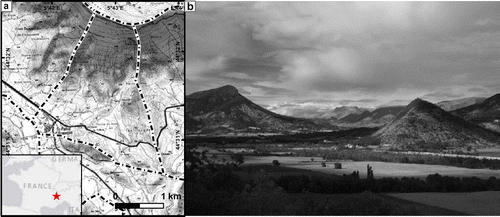
Figure 1. (a) Example area delineated with dashed line assigned to student-pair, Topographic data: SCAN 25 (IGN, Citation2012). Inset: location of the fieldwork site, (b) photo showing typical limestone outcrops, river terraces and alluvial fans in the area
In the preparation period, executed on campus, students learn fieldwork methods the general geology and geomorphology of the area. Furthermore, students explore their research area (A1 in Table ) and formulate hypotheses (A2) using aerial photographs and a topographic map.
Table 1. Learning goals of various aspects of a fieldwork and ways to improve these by using GIS methods.
During the fieldwork period, student-pairs spend two-and-a-half week researching their own area, the remaining time is spent on excursions and field activities that are not related to the students’ own research area. The goals of the research are to learn to perform observations (B1 in Table ), interpret the spatial pattern in these observations (B2) and their relation to existing data (B3), and to reconstruct the geological and geomorphological history (B4). Students collect about 100 field observations, draw maps and write a report. The fieldwork is driven by setting-up working hypotheses, which students test with field observations.
New GIS methods in fieldwork preparation
In the fieldwork preparation period, new tutorials were introduced where student use Google Earth (Google Inc, Citation2013), and satellite imagery and a digital elevation model (DEM) using QGIS (QGIS Development Team, Citation2015), see A1 in Table . These, and the existing aerial photograph tutorial, focused on exploration of the research area and resulted in a set of maps (A2), working hypotheses, and a list of locations to visit in the field (A3). (Full text of these tutorials is available in Marra, Citation2016a).
In the aerial photograph and Google Earth tutorials, students formed hypotheses on the geology and geomorphology of their fieldwork area. The aerial photos give an overview of the research area, while Google Earth gives more flexibility in viewing at different scales and angles. Google Earth is considered engaging tool valuable for geoscience education in general (Bailey, Whitmeyer, & De Paor, Citation2012), and can bridge between the broader content of classroom lectures and the students’ research areas (Monet & Greene, Citation2012). Students made a fieldwork plan consisting of interesting locations together with their expectation of what to find there in the field.
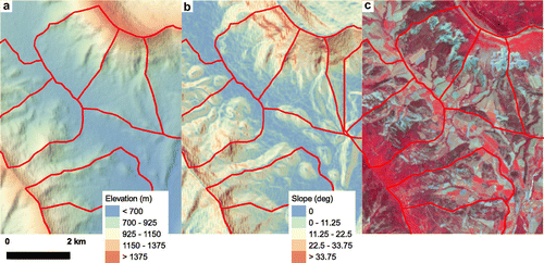
The QGIS tutorial focussed on quantitative data. Students used a DEM at 30 m resolution (SRTM, USGS, Citation2015a) and a pre-processed Landsat-8 satellite image (USGS, Citation2015b) in both natural colours and false-colour to show vegetation patterns. Students made a slope-map from the DEM and described the vegetation patterns using the satellite imagery (Figure ). With this information, they made a digital map with hypothesised geomorphological units.
Figure 2. Examples of maps made by students in the preparation of their fieldwork (a) elevation map, (b) slope map and (c) false-colour satellite image.
New GIS methods during fieldwork
During the actual fieldwork, data collection in the field remained the same, using a paper notebook, GPSs, geological compass, etc. In addition, students managed their data with QGIS at the end of each day in their accommodation (B1, Table ). They digitized their fieldbook using an Excel spreadsheet (Figure (a)) in combination with QGIS. (Templates are available in Marra, Citation2016b). With this data, students were encouraged to make maps of spatial pattern in rock type, grains-size, soil properties, etc., and to overlay their observations on the topographic map, DEM and satellite images (B2, Figure (b)).
Figure 3. Digital workflow during the fieldwork. (a) Part of an Excel-sheet of students’ observations; (b) example of observation map made by students, showing soil clast size patterns (higher is coarser); (c) students’ digital geomorphological map.
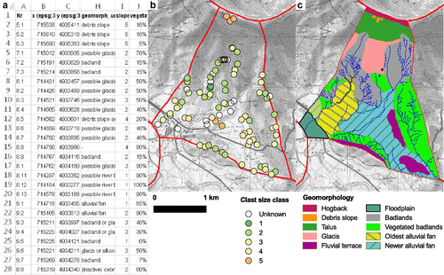
Students made digital maps (Figure (c)) instead of hand drawn maps. By drawing these maps in QGIS, the datasets and observations points are directly available as an aid to make these maps (B3), and students could make use of additional data sources to combine with their own field data to confirm or reject hypotheses (B4).
Evaluation methods
To evaluate the intended benefits of the use of GIS in the field course, students filled in questionnaires and a focus group was interviewed. All students used the new components of the preparation period (Section New GIS methods in fieldwork preparation), and a pilot group of about half of the number of students used the new workflow during the fieldwork (Section New GIS methods during fieldwork).
A questionnaire was taken after the fieldwork preparation period. This questionnaire was intended to compare how the students experienced the classic and new methods, and to what extent the preparation contributed to the intended learning outcomes. A second questionnaire was taken after the fieldwork period. In this questionnaire the students had to reflect on the usefulness of the preparatory assignments for their fieldwork and use of GIS during the fieldwork. With the latter questionnaire, we compared students that used GIS and those that relied on classic methods during their fieldwork.
We asked the students questions on the following topics:
| (1) | How the students experienced the preparatory tutorials, whether these contributed to the students understanding of their fieldwork area prior to the fieldwork, and which elements of the preparation contributed to the fieldwork in retrospect (learning goals A1, A2, A3 in Table ). | ||||
| (2) | How students collected and managed their data, how the new digital methods were used and if this contributed to the students’ understanding of the landscape and their maps (B1, B2, B3). | ||||
| (3) | Which data sources the students used, and whether this contributed to the fieldwork planning, the students’ understanding of the landscape and the quality of their maps (B2, B3). | ||||
| (4) | How students and their supervisors experienced the use of the new methods. | ||||
The questionnaires consisted of 4-step Likert rating scale (Likert, Citation1932) and free-text questions. A 4-step scale was used to avoid students picking the neutral option when they had a weak opinion about the subject, and to make strong visualisation of the results based on the method by Robbins, Heiberger, Court, and Hall (Citation2011). Using a 4-step scale does not decrease the reliability of such a rating scale (Lozano, García-Cueto, & Muñiz, Citation2008).
Differences in the mean of Likert-scale were assessed with a dependent-samples t-test for the difference between questions and with an independent t-test for the differences between GIS vs non-GIS users. Although the response scale could be considered non-continuous, a t-test is still a powerful tool to evaluate rating scales (de Winter & Dodou, Citation2010).
A number of 68 (out of 70) students completed the evaluation after the preparation period and 64 students completed the questionnaire after the fieldwork, 23 of them were part of the pilot group that used GIS. Six students from the pilot group were interviewed by a person not involved in the fieldwork and unfamiliar to the students. The interviews were anonymous to promote honest responses. In this interview, students elaborated on their experiences, difficulties and improvements.
Furthermore, the experiences and opinions of six members of the staff involved in the field-course as supervisors were used to reflect of the students’ evaluation.
Results of the evaluation
Fieldwork preparation tutorials
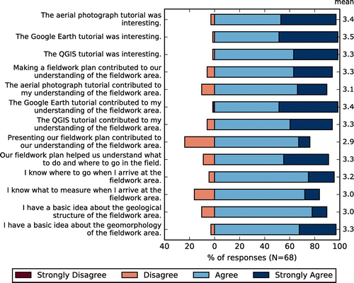
The Google Earth tutorial received the highest scores (average = 3.5) regarding how interesting students found the tutorials, although the other tutorials followed closely (3.3, 3.4, Figure ). Similarly, when asked if the tutorials contributed to their fieldwork preparation, students gave the highest score to the Google Earth tutorial (3.4), followed by the GIS-tutorial (3.3).
Figure 4. Students’ responses to questions of the pre-fieldwork questionnaire.
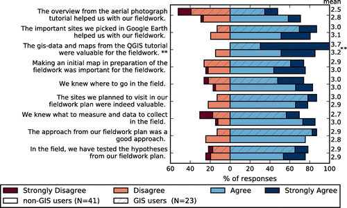
After the fieldwork, we asked the students if the preparatory assignments helped them with their fieldwork. The average scores for the GIS tutorial was the highest for both GIS and non-GIS users, compared to the aerial photo and Google Earth practical (Figure ). Interestingly, students that used GIS gave a lower score to the aerial photograph tutorial than non-GIS users (2.5 and 2.8), and a higher score to the GIS tutorial (3.7 and 3.2) (Figure ).
Figure 5. Students’ responses to questions asked after the fieldwork, concerning the preparation, grouped by students that did or did not use GIS during the fieldwork.
On the open questions, the large majority (48 out of 68 completed surveys) of the students answered that seeing the area in 3D is strongest point of using aerial photographs. For Google Earth most students (24/68) identify that familiarizing with the research area is the most useful part of this tutorial, and many students praise the flexibility and different angles from which they could view the research area (17/68) and finding location to visit (16/68) (Figure ). For the GIS tutorial, most students indicate seeing many maps as the most useful part if this tutorial (24/68), followed by making a geomorphological map (16/68), and the use of quantitative data (10/68). Specifically, for making a map students praise the synthesis of hypotheses during this exercise, an example of a response: “Getting a final, clear view/hypothesis on the geomorphology of the area before going into the field”, “Seeing different maps and combining them really helped us to make hypotheses of the area.” Regarding the use of quantitative data, a student responded: “With maps like elevation and slope, you can already test hypotheses because we used real values instead of only ideas.”
Figure 6. Categorized responses to open-questions on the most useful parts (left) and possible improvements (right) of the preparatory tutorials.
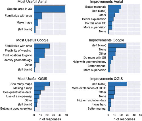
Points for improvements are provided by the students mainly for the aerial photo tutorial, students indicate they wanted better materials (20/68) and instructions (18/68) (Figure ). For the other two tutorials, most students left this question blank, filled in “None” or a similar response. For the GIS tutorial, several students requested more explanation of the software (10/68), mostly to deal with common issues like changing or deleting polygons. The remaining responses covered diverse topics.
Fieldwork planning
Making a fieldwork plan in the preparation period received the lowest appreciation of the students (Figure ). In the interview, students indicated there was not enough time to make a complete plan and to receive feedback. The plan describes places to visit for the first few days, however in the field these plans quickly change. As one of the students stated: “You think of better places to go, it is difficult to make this assessment on forehand”, and: “Some places turn out to be inaccessible by cliffs or stingy bushes.”
Although the fieldwork plans and hypotheses quickly superseded in the field, supervisors felt that making and presenting the fieldwork plan was valuable. This part of the preparation made students think about their approach in the field, and made it easier to discuss steps to prove or reject hypotheses during the fieldwork.
Data collection and mapping
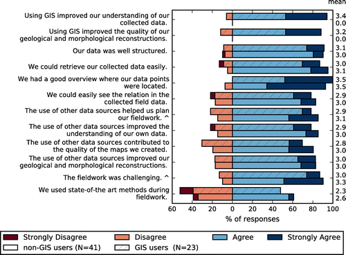
Students that used GIS during the fieldwork give a positive reaction on the statements that GIS improved their understanding of their collected data (3.4) and the quality of their maps (3.2). However, there are no large differences in responses between students that used GIS and those that did not (Figure ). Assessing these differences based on this questionnaire is difficult, because students cannot reflect on the difference in method as they have not experienced both. Students in the focus group were asked for their opinions on the use of GIS, which yielded enthusiastic responses, e.g. “GIS is a real improvement, otherwise you have to draw all points manually and use transparent paper. We already spend too much time on things that are so much easier with a computer.”
Figure 7. Students’ responses to questions regarding the fieldwork period, grouped by students that did or did not use GIS during the fieldwork.
In the students’ reports, we see that the GIS-users made use of elevation profiles made from a DEM using QGIS as an alternative to making such a profile from contour lines of the topographic map. Besides elevation profiles, students have used the DEM and slope-map as an aid to map the boundaries of geomorphological units that were difficult to observe in the field. None of the students used the provided satellite images in their report to support their findings. These could be used to classify vegetation and to complement field observations on vegetation. To make students use the satellite image better, they would need to be asked to make a qualitative assessment, for example by using a vegetation index based on infrared data and compared to observed vegetation properties.
Technical quality and issues
Several students indicated in the questionnaire that they wanted more instructions of QGIS (8 out of 23 from the pilot group). Some of these students experienced a lack of skills: “If we practiced more with GIS, everybody could have made much more beautiful maps”, while others indicted they wanted to do more than required: “I wish they (supervisors) explained more of the functions of QGIS, because there are so many more things you could do to make fieldwork easier.” Supervisors indicated that hand drawn-maps were in general more appealing to see. However, a quality difference was present for both methods, which shows that quality difference is not merely the result of a digital- or hand-drawn map.
A number of 5 students out of 23 from the pilot group indicated to have experienced technical difficulties while using QGIS during fieldwork. There were three occasions where the transfer of the digital data-set from student to supervisor failed. This is the result of the data structure of a GIS project, consisting of multiple data-files with one central project-file referencing the data-files. As the students did not fully grasp this structure, only a part of the data structure was transferred in several cases.
Students indicate that using GIS is hard at first: “The first time it is like magic, you have no idea what happens, it is not the easiest software to work with” Also, students indicate that not all supervisors could equally help with GIS and sometimes had to forward problems to more knowledgeable members of staff.
The main concern supervisors had, is that they do not feel confident with supervising students using GIS or helping with technical difficulties. This an important point for making such changes; it requires a good preparation of the students so they hardly need technical help, and teaching the supervisors on the software and techniques that the students use.
Motivation of using GIS
Fieldwork in general is a positive experience for students, as one of the students’ stated: “… fieldwork is essential because the type of skills are not learned from a book.”, or “You now see everything we learned in the field, therefore you start looking at it differently.”
Student indicated that learning GIS is important for your career perspective since many job-vacancies ask for GIS-skills. “Skills you learn should prepare you for labour market”. Similarly, students indicate that they prefer to use the same methods as the staff uses for their research to manage and process data. In that perspective, using advanced methods could be motivating for the students, which may help them overcome the hurdle of learning them.
Discussion
In this paper, we presented changes made to a research-focussed field course to incorporate the use of GIS, and the results of the evaluation thereof. In this section, we summarise and elucidate on the intended learning benefits, and provide recommendation for further improvements and similar courses.
Benefits and recommendations for using GIS in a field course
Preparing for fieldwork using Google Earth and QGIS in addition to the classic stereo-aerial photographs, was considered valuable for their fieldwork and a good experience by the students. Students indicate the value of exploring their research area with quantitative data using GIS (learning goal A1 in Table ).
In addition to just exploring, students made hypotheses and a fieldwork plan in the preparation phase (A2, A3 in Table ). However, these were quickly superseded by better hypotheses once in the field and several planned routes were inaccessible in reality. This did not speed up or improve the quality of the fieldwork per se, but we consider this an exercise in formulating hypotheses. For improvements and future cases, making such plans and hypotheses are more valuable when the students already have some experience with fieldwork and better know what to expect.
Students produced well-structured data-set using GIS during their fieldwork (B1), but the evaluation remains unclear about whether this resulted in a better understanding of the spatial patterns compared to students that did not use GIS (B2 and B4). Most students made use of elevation profiles, several students explicitly used spatial patterns of grain-sizes to support their interpretation, but none made use of the satellite image showing vegetation patterns. In the presented case, students were hinted at using these sources of data, but were not given step-by-step instructions. For first-year students we recommend to require the use of such GIS analyses in the assignment to promote their usage.
Making a map digitally was not faster or slower than the analogue alternative (B3). The quality of digital and analogue maps varied between students, with hand-drawn maps being more appealing in general. We recommend a good preparation to familiarize the students with the software for a smooth experience in the field and to improve visual quality of the maps.
Learning experience and motivation of students
GIS is increasingly becoming a valuable tool in geography research and an important skill in industry. The number of GIS courses increases, but courses focused on GIS alone do not provide a realistic view of its applications (Şeremet & Chalkley, Citation2014; Sinton, Citation2009). Using GIS as part of a fieldwork is an easy way to introduce GIS in a relevant context rather than in a GIS-specific course and enhances the student’s view of the possibilities of GIS.
Using GIS techniques has a motivating effect on some students. We noticed that tech-savvy students explored additional functionality and invested more time on making their maps. Students indicated they liked the use of digital and quantitative data as this gave a different view on their fieldwork area. It seems that both the use of new techniques as well as the additional analytical opportunism are a source of motivation (Carlson, Citation2007; Welsh et al., Citation2015). In addition, students indicated they also liked using GIS because it is a relevant skill for future research and for the labour market.
With GIS-data, students had to formulate hypotheses and were had to think about what to find in the field before going there. This exercise forced them to combine theoretical knowledge from lectures and abstract data to an expectation on what to find in the field.
The latter two points are associated with skills like abstract thinking and reflection, i.e. the assimilator learning style (Healey & Jenkins, Citation2000; Kolb, Citation1984). These skills are a valuable addition to a fieldwork, which is often dominant in practical skills like measuring, reporting observations, planning, or learning by experiencing in general. With the use of GIS, different types of learning styles are combined in a field course, which enhances the learning experience of the students (Healey & Jenkins, Citation2000).
Technical issues and staff-support
In our case, several students experienced’ technical issues, which is in most cases a lack of understanding and practice with the software, just as that students may have difficulties using advanced analyses with pencil and paper. The latter case is not deemed a “technical” issue, but likewise requires help of knowledgeable staff. Students indicate that GIS has a steep learning curve, so the advice is to reserve enough time for practice in the preparation period and not give up or be tempted to revert to non-GIS methods.
Several members of staff raised the concerns of not being able to help students with questions on GIS, similar to the findings of Fletcher, France, Moore, and Robinson (Citation2007), who indicated that a limited understanding of new technologies is a barrier in incorporating these in field courses. This is especially an issue for field courses as knowledgeable staff members are not available for support. Possible solutions are to train all involved staff in the same techniques as the students use, and to make use of distant-learning techniques like screencasts (e.g. Ooms et al., Citation2015) for common procedures and remote supervision to reduce the technical demand of on-site staff members.
Additional opportunities and recommendations
The teaching materials described in this paper were made for a first-year Earth Sciences field course in the French Alps. In this section we describe additional opportunities and recommendation for using these materials for similar initiatives.
The tutorials for preparing a fieldwork are based on the use of Google Earth and QGIS. Google Earth can be used in a wide range of topics (Bailey et al., Citation2012). In addition to global imagery and elevation data, many areas contain historic and ground-based (street-view) imagery. For geological exploration, Google Earth combined with an additional elevation data source can be used to map geological contacts and estimate strike and dip angles (Hasbargen, Citation2012). Google Earth is particular useful for showing both a broad overview as well as local details, and can be strong tool combine insights from the general landscape and information from small research areas.
We choose to use QGIS as it is relatively easy to use for basic analyses and digitizing, available for free and without a connection to a licence server. There are many alternate chooses for GIS-software (GisGeography, Citation2016), with ArcGIS and GRASS being widely used. To mitigate issues with demanding hardware requirements and licencing during a fieldtrip, ArcGIS could be run in a cloud service (Mui, Nelson, Huang, He, & Wilson, Citation2015).
For the QGIS tutorial, a 30-m SRTM elevation model and 15-m Landsat-8 image was used (USGS, Citation2015a, 2015b). These data are available worldwide and good to get an overview of areas of several kilometres across. The datasets were pre-processed for the fieldwork, but the students did the visualisation and derivation of a slope map themselves. Although this is merely pressing a few buttons, student’s positive reaction on using the slope map may be encouraged as they made and visualised the data themselves.
The 30 m resolution was just enough for our case, but it mainly shows the general structure of the fieldwork areas (a few km in size). For future use, we recommend the use of a higher resolution DEM. Using a higher resolution model increases the details and quality of the maps and derived hypotheses, which may therefore be of higher value in the field. Furthermore, advanced GIS techniques can be used to identify morphological features (Seijmonsbergen, Hengl, & Anders, Citation2011) or the vegetation could further explored using a NDVI-index (Tucker, Citation1979).
In the presented case, we used a workflow with a paper notebook in the field and digital methods for processing field data afterwards on a daily basis. We choose not to use mobile devices as we anticipated issues with batteries and adverse weather conditions. Nevertheless, mobile GIS systems on smartphones, tablets or PDAs (Wagtendonk & De Jeu, Citation2007) could be used for this purpose, especially with rugged weatherproof equipment. Using mobile GIS integrates data collection and data processing, and students can access digital maps in the field, which may help to relate data to reality.
Conclusions
This paper describes newly introduced GIS-methods in a first-year field course to the French Alps. Students explored their fieldwork, using a DEM, satellite image and aerial photographs. During the actual fieldwork, a pilot group stored and analysed their field observations using QGIS and drew digital geomorphological maps. The new approach was evaluated using questionnaires and a group-interview. We draw the following conclusions:
| • | Students praise the exploration of their fieldwork area using Google Earth and QGIS, and both the students that did and did not use GIS during the fieldwork indicate the preparatory GIS-assignment as the most valuable for their fieldwork. | ||||
| • | Plans and hypotheses made in the preparation were a valuable exercise, although quickly superseded by better ones when the students were in the field. | ||||
| • | Students utilized GIS during fieldwork to explore spatial patterns in their data and the relation with existing GIS-data, although it remains unclear if this improved the quality of the students’ interpretations. | ||||
| • | Students were on general positive about the use of GIS. They indicate that working with a skill that is relevant for future work was motivating and tech-savvy students spend more time and effort on their work. | ||||
| • | Using GIS introduces skills related to abstract thinking and reflection, which is a valuable addition to the students’ learning experience in a field course that otherwise consist of mainly practical skills. | ||||
| • | A few students experienced technical issues, mainly with transferring GIS-data to supervisors. These issues can be resolved with more training and step-by-step instructions before and during the fieldwork. | ||||
| • | Some supervisors had concerns about not being able to help students with specific problems with the software. These concerns call for a good preparation for the students, as well as teaching supervisors. | ||||
Funding
This work was supported by Utrechts Stimuleringsfonds Onderwijs (USO) [grant number CB.842400.3.01.064]; and by the faculty of Geosciences, Universiteit Utrecht.
Disclosure statement
No potential conflict of interest was reported by the authors.
Online resources
Full text of tutorials: doi:10.6084/m9.figshare.3472940 (Tutorials)
Digital fieldbook templates: doi:10.6084/m9.figshare.3472952 (Templates)
Acknowledgements
We are grateful for the support of the fieldwork staff and students for their cooperation. We thank three anonymous reviewers and the editor for their constructive comments on an earlier version of this manuscript.
References
- Bailey, J. E., Whitmeyer, S. J., & De Paor, D. G. (2012). Introduction: The application of Google Geo tools to geoscience education and research. GSA Special Paper, 492, vii–xix. doi:10.1130/2012.2492(00)
- Bearman, N., Jones, N., André, I., Cachinho, H. A., & DeMers, M. (2016). The future role of GIS education in creating critical spatial thinkers. Journal of Geography in Higher Education, 1–15. Retrieved from http://www.tandfonline.com/doi/full/10.1080/03098265.2016.1144729, doi:10.1080/03098265.2016.1144729
- Boyle, A., Maguire, S., Martin, A., Milsom, C., Nash, R., Rawlinson, S., … Conchie, S. (2007). Fieldwork is good: The student perception and the affective domain. Journal of Geography in Higher Education, 31, 299–317. Retrieved from http://www.tandfonline.com/doi/abs/10.1080/03098260601063628, doi:10.1080/03098260601063628
- Carlson, T. (2007). A field-based learning experience for introductory level GIS students. Journal of Geography, 106, 193–198. Retrieved from http://dx.doi.org/10.1080/00221340701697636\nhttp://www.tandfonline.com/doi/abs/10.1080/00221340701697636, doi:10.1080/00221340701697636
- de Winter, J. C. F., & Dodou, D. (2010). Five-point likert items: t test versus Mann-Whitney-Wilcoxon. Practical Assessment, Research & Evaluation, 15, 1–16. Retrieved from http://pareonline.net/pdf/v15n11.pdf, doi:citeulike-article-id:10781922
- Favier, T., & van der Schee, J. (2009). Learning geography by combining fieldwork with GIS. International Research in Geographical and Environmental Education, 18, 261–274. Retrieved from http://www.tandfonline.com/doi/abs/10.1080/10382040903251091. doi:10.1080/10382040903251091
- Fletcher, S., France, D., Moore, K., & Robinson, G. (2007). Practitioner perspectives on the use of technology in fieldwork teaching. Journal of Geography in Higher Education, 31, 319–330. Retrieved from http://search.ebscohost.com/login.aspx?direct=true&db=ehh&AN=24905677&site=ehost-live, doi:10.1080/03098260601063719
- Fuller, I., Edmondson, S., France, D., Higgitt, D., & Ratinen, I. (2006). International perspectives on the effectiveness of geography fieldwork for learning. Journal of Geography in Higher Education, 30, 89–101. Retrieved from http://www.tandfonline.com/doi/abs/10.1080/03098260500499667, doi:10.1080/03098260500499667
- GisGeography. (2016). Mapping out the GIS software landscape. gisgeography.com. Retrieved July 20, 2016, from https://perma.cc/VVU7-FSSB
- Google Inc. (2013). Google Earth pro 7.1.2.2041. Retrieved from https://www.google.com/earth/
- Hasbargen, L. E. (2012). A test of the three-point vector method to determine strike and dip utilizing digital aerial imagery and topography. In S. J. Whitmeyer, J. E. Bailey, D. G. De Paor, & T. Ornduff (Eds.), Google earth and virtual visualizations in geoscience education and research: GSA special papers 492 (Vol. 2492, pp. 199–208). Retrieved from http://specialpapers.gsapubs.org/lookup/doi/10.1130/2012.2492(14), doi:10.1130/2012.2492(14)
- Healey, M., & Jenkins, A. (2000). Kolb‘s experiential learning theory and its application in geography in higher education. Journal of Geography, 99, 185–195.10.1080/00221340008978967
- Hope, M. (2009). The importance of direct experience: A philosophical defence of fieldwork in human geography. Journal of Geography in Higher Education, 33, 169–182. Retrieved from http://www.tandfonline.com/doi/abs/10.1080/03098260802276698, doi:10.1080/03098260802276698
- IGN. (2012). SCAN 25 Version 3. Retrieved from http://professionnels.ign.fr/scan25
- Karssenberg, D., Burrough, P. A., Sluiter, R., & de Jong, K. (2001). The PCRaster software and course materials for teaching numerical modelling in the environmental sciences. Transactions in GIS, 5, 99–110. doi:10.1111/1467-9671.00070
- Kent, M., Gilbertson, D. D., & Hunt, C. O. (1997). Fieldwork in geography teaching: A critical review of the literature and approaches. Journal of Geography in Higher Education, 21(2015), 313–332. doi:10.1080/03098269786183
- Kim, M., & Bednarz, R. (2013). Development of critical spatial thinking through GIS learning. Journal of Geography in Higher Education, 37, 350–366. Retrieved from http://www.tandfonline.com/doi/abs/10.1080/03098265.2013.769091, doi:10.1080/03098265.2013.769091
- Klein, P. (2003). Active learning strategies and assessment in world geography classes. Journal of Geography, 102(2015), 146–157. doi:10.1080/00221340308978539
- Kolb, D. A. (1984). Experiential learning: Experience as the source of learning and development (pp. 20–38). New Jersey: Prentice Hall Inc. doi:10.1016/B978-0-7506-7223-8.50017-4
- Krakowka, A. R. (2012). Field trips as valuable learning experiences in geography courses. Journal of Geography, 111, 236–244. Retrieved from http://www.tandfonline.com/doi/abs/10.1080/00221341.2012.707674, doi:10.1080/00221341.2012.707674
- Lee, J., & Bednarz, R. (2009). Effect of GIS learning on spatial thinking. Journal of Geography in Higher Education, 33, 183–198. Retrieved from http://www.tandfonline.com/doi/abs/10.1080/03098260802276714, doi:10.1080/03098260802276714
- Likert, R. (1932). A technique for the measturement of attittudes. Archives of Psychology, 22, 1–55. Retrieved from http://www.voteview.com/pdf/Likert_1932.pdf\nhttp://psycnet.apa.org/psycinfo/1933-01885-001, https://www.researchgate.net/publication/200086112_A_Technique_for_Measurement_of_Attitudes
- Lozano, L. M., García-Cueto, E., & Muñiz, J. (2008). Effect of the number of response categories on the reliability and validity of rating scales. Methodology, 4, 73–79. doi:10.1027/1614-2241.4.2.73
- Marra, W. A. (2016a). Fieldwork area exploration tutorials (for undergraduate field course). figshare. Retrieved from http://dx.doi.org/10.6084/m9.figshare.3472940. doi:10.6084/m9.figshare.3472940
- Marra, W. A. (2016b). Digital notebook template (spreadsheet) for geology and geomorphology. figshare. Retrieved from http://dx.doi.org/10.6084/m9.figshare.3472952. doi:10.6084/m9.figshare.3472952
- Monet, J., & Greene, T. (2012). Using Google Earth and satellite imagery to foster place-based teaching in an introductory physical geology course. Journal of Geoscience Education, 60, 10–20. Retrieved from http://nagt-jge.org/doi/abs/10.5408/10-203.1, doi:10.5408/10-203.1
- Mui, A. B., Nelson, S., Huang, B., He, Y., & Wilson, K. (2015). Development of a web-enabled learning platform for geospatial laboratories: Improving the undergraduate learning experience. Journal of Geography in Higher Education, 1–13. Retrieved from http://www.tandfonline.com/doi/full/10.1080/03098265.2015.1039503, doi:10.1080/03098265.2015.1039503
- Ooms, K., De Maeyer, P., De Wit, B., Maddens, R., Nuttens, T., Van De Weghe, N., & Vervust, S. (2015). Design and use of web lectures to enhance GIS teaching and learning strategies: The students’ opinions. Cartography and Geographic Information Science, 42, 271–282. Retrieved from http://www.tandfonline.com/doi/abs/10.1080/15230406.2015.1011236, doi:10.1080/15230406.2015.1011236
- QGIS Development Team. (2015). QGIS 2.8. Retrieved from http://qgis.org/
- Revell, A., & Wainwright, E. (2009). What makes lectures ‘unmissable’? Insights into teaching excellence and active learning. Journal of Geography in Higher Education, 33, 209–223. Retrieved from http://hdl.handle.net/2438/3045, doi:10.1080/03098260802276771
- Remmen, K. B., & Frøyland, M. (2014). Implementation of guidelines for effective fieldwork designs: Exploring learning activities, learning processes, and student engagement in the classroom and the field. International Research in Geographical and Environmental Education, 23, 103–125. Retrieved from http://www.tandfonline.com/doi/abs/10.1080/10382046.2014.891424, doi:10.1080/10382046.2014.891424
- Robbins, N. B., Heiberger, R. M., Court, C., & Hall, S. (2011). Plotting likert and other rating scales. Joint Statistical Meetings (2005), 1058–1066. Retrieved from http://www.amstat.org/sections/srms/proceedings/y2011/Files/300784_64164.pdf
- Seijmonsbergen, A. C., Hengl, T., & Anders, N. S. (2011). Semi-automated identification and extraction of geomorphological features using digital elevation data. In Developments in earth surface processes (Vol. 15, pp. 297–335). Elsevier B.V. Retrieved from http://linkinghub.elsevier.com/retrieve/pii/B9780444534460000100, doi:10.1016/B978-0-444-53446-0.00010-0
- Şeremet, M., & Chalkley, B. (2014). Student perspectives on the teaching of geographical information systems (GIS) in geography degrees. Journal of Geography in Higher Education, (2015), 1–19. doi:10.1080/03098265.2014.963795
- Sinton, D. S. (2009). Roles for GIS within higher education. Journal of Geography in Higher Education, 33(Suppl. 1), S7–S16. Retrieved from http://www.tandfonline.com/doi/abs/10.1080/03098260903034046, doi:10.1080/03098260903034046
- Tonts, M. (2011). Using problem-based learning in large undergraduate fieldwork classes: An Australian example. International Research in Geographical and Environmental Education, 20, 105–119. Retrieved from http://www.tandfonline.com/doi/abs/10.1080/10382046.2011.564784, doi:10.1080/10382046.2011.564784
- Tucker, C. J. (1979). Red and photographic infrared linear combinations for monitoring vegetation. Remote Sensing of Environment, 8, 127–150. doi:10.1016/0034-4257(79)90013-0
- USGS. (2015a). Digital elevation: SRTM 1 arc-second (30 m). Retrieved from http://earthexplorer.usgs.gov/
- USGS. (2015b). Landsat archive: L8 OLI/TIRS. Retrieved from http://earthexplorer.usgs.gov/
- Wagtendonk, A. J., & De Jeu, R. A. M. (2007). Sensible field computing: Evaluating the use of mobile GIS methods in scientific fieldwork. Photogrammetric Engineering & Remote Sensing, 73, 651–662.10.14358/PERS.73.6.651
- Warburton, J., & Higgitt, M. (1997). Improving the preparation for fieldwork with “IT”: Two examples from physical geography. Journal of Geography in Higher Education, 21, 333–347. Retrieved from <GotoISI>://A1997YH10500003, doi:10.1080/03098269708725440
- Welsh, K. E., Mauchline, A. L., Powell, V., France, D., Park, J. R., & Whalley, W. B. (2015). Student perceptions of iPads as mobile learning devices for fieldwork. Journal of Geography in Higher Education, 1–20. Retrieved from http://www.tandfonline.com/doi/full/10.1080/03098265.2015.1066315, doi:10.1080/03098265.2015.1066315