
ABSTRACT
Third year geoscience students were introduced to digital tools for fieldwork, Fieldmove on iPads, in a capstone field mapping course at Oslo University, Norway. Despite little prior experience with digital tools for fieldwork, they became independent Fieldmove users in a few hours. They self-report positive cognitive impacts, including positive effects on quality of fieldwork, maps and reports. However, submitted course material suggest students achieved similar levels of understanding with and without digital tools. We hypothesize that students’ confidence in their work increases when supported by digital tools, however, they may also overrate their proficiency due to the ease of collecting large data sets, and the professional look of the digital outputs. Students report both positive and negative effects on teamwork; observations suggest this reflects sharing of devices rather than use of digital tools per se. The students also report pronounced positive affective impacts, which appear to be the main effect of the digital tools in this study. Overall, the students are very positive to digital tools in fieldwork, preferring they were introduced early during the bachelor program, but after traditional field methods are learnt. When given a choice, most students chose to combine traditional and digital tools for their fieldwork.
Introduction
Fieldwork is typically an integral part of higher education Earth Science curricula (Mogk & Goodwin, Citation2012). The advent of affordable, lightweight and precise digital tools is currently transforming geological fieldwork. Among the benefits are fast high precision location of observations and measurements on digital maps, rapid acquisition and recording of large data sets, visualization of the data in the field, and access to digital data sets such as geophysical maps in the field (House, Clark, & Kopera, Citation2013). Geoscience educators now need to address how this digital transformation in field geology should translate into teaching practices. Should digital tools be used in geoscience field teaching, and if so, when should they be introduced? Should they supplement or supplant the traditional field techniques? To answer these questions, more has to be understood about the impacts of digital tools on the students’ learning experience. This pilot study reports how two cohorts of 3rd year geology students at Oslo University, Norway, experienced a trial with the software Fieldmove on Ipads in a geological field mapping course in the spring of 2018 and 2019. Until this trial, pencil and paper had been the tools of choice for mapping, taking field notes and making sketches, and structural measurements had been taken using clinometer compasses. Although the students commonly used GPS devices, these were typically used alongside paper maps. Here, we report how the students perceived the impact of the digital tools on the cognitive, affective and social domains, based on self-reporting and observations of the fieldwork.
Background
Digital tools in geoscience field work
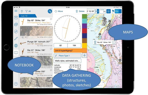
A growing body of literature reports on the implementation of digital tools in geological fieldwork (House et al., Citation2013; McCaffrey et al., Citation2005; Pavlis, Langford, Hurtado, & Serpa, Citation2010), and in teaching of geoscience in the field (e.g. De Donatis, Alberti, Cesarini, Menichetti, & Susini, Citation2016; Menking & Stewart, Citation2007; Senger & Nordmo, Citationin press; Swanson & Bampton, Citation2009; Walker & Black, Citation2000; Whitmeyer, Citation2012). Pavlis et al. (Citation2010, p. 275) for example states that “Paper-based geologic mapping is now Archaic […]”, and the literature on teaching field geology echoes this in stressing the importance of students learning digital field skills to prepare them for future geoscience jobs. In many instances the digital fieldwork is built around a GIS (Geographical Information System) program such as ArcGIS or QGIS, run on a portable device (De Donatis et al., Citation2016; Whitmeyer, Citation2012). In terms of field teaching, most reports are positive in the sense that students self-report that they appreciate the digital tools. However, using GIS programs such as ArcGIS is typically challenging for beginners (Marra, van de Grint, Alberti, & Karssenberg, Citation2017; Whitmeyer, Citation2012). This is also the current authors’ experience, and is reflected in the commonly voiced concern among teaching staff that the students may end up using a significant amount of the time available for fieldwork to learn how to operate computer programs (Welsh, Mauchline, Park, Whalley, & France, Citation2013; Whitmeyer, Citation2012). A simpler alternative to highly capable but complex GIS software is now available in the form of Fieldmove (Midland Valley Inc.; Muir, Citation2015), which was launched in June 2015. Fieldmove brings together many of the Ipads capabilities that are of interest to Earth scientists in one app. For example, Fieldmove can measure orientations and visualise the results in a Stereonet, allows the user to take photos and sketch on these, and take digital notes. Similar to a fully-fledged GIS program, all data are georeferenced and shown on a digital map of choice (). For more advanced analysis, the data can be exported to for example ArcGIS.
Figure 1. The interface of Fieldmove on Ipad. Georeferenced maps of any kind can be imported as layers and shown on the device, in this case the 1:50 000 bedrock map from the Norwegian Geological Survey.
The setting
In the last couple of years the geoscience department at Oslo University and our colleagues at other Norwegian universities have begun experimenting with introducing more digital tools in field teaching. This has been prompted by our own increasing use of digital devices in the field, changing practices in the industry and geological surveys, a generally greater digital literacy among the students and teachers, the increasing availability of apps, programs and portable devices that make it practical, and the pursuit of better learning outcomes compared to traditional methods (cf. Welsh et al., Citation2013). At Oslo University the geology students end the Geology and Geography bachelor program with a 10 ECTS credits geological field mapping course. The course comprise three parts: 1) interpreting geological maps representing different tectonic settings in Norway, 2) field methods in theory and practice, and 3) field mapping projects carried out in groups of 2 to 4 students. In 2017 we conducted a pilot study in which one student group did their final 5 days field mapping project using ArcGIS software on a ruggedized laptop. The students reported their experience at the 33rd Geological Wintermeeting in Copenhagen (Aanvik, Slang, Rian, & Oftedal, Citation2017). It can briefly be summarised as follows: the students were very enthusiastic about using digital tools in the field, and strongly recommended that more such tools be implemented in our field teaching. However, they also reported that it had been time consuming and challenging to use the ArcGIS software in the field, and proposed that other software/hardware combinations be tried out. In response to this recommendation, we decided to do a field trial of the Fieldmove app run on 10.5 inch Ipad Pros in the field mapping course in the spring of 2018, which was continued in the spring of 2019. In order to share our experiences with our fellows, we decided to gather some observations from the trial in collaboration with a student from the geoscience teacher education programme (SVJ), who observed parts of the course in 2018.
Purpose of study
Digital tools are increasingly introduced in teaching geoscience fieldwork, but come at a price. To take advantage of the digital tools we may have to adapt the teaching, invest in new equipment, and spend scarce teaching time to allow students to learn to use the new tools. The use of digital tools may also have unintended impacts on the student learning experience in both the cognitive, affective and social domains. The main aim of this study is to investigate the student perceptions of digital tools in fieldwork. The objectives were to identify:
What were the students’ experiences with the digital tools?
How do the students assess the impact of the digital tools on different aspects of the fieldwork?
After using the digital tools, what place do the students see for digital tools in field teaching?
The field trial
The first field sessions during the course were undertaken using traditional field equipment, i.e. conventional topographic maps, notebooks and clinometer compasses. Fieldmove was first introduced in the classroom; after a 15 minute introduction to the program the students were given 30 minutes to try it out by setting up a project, locating themselves geographically with Fieldmove, and measuring the strike and dip of some planar surfaces and saving these in Fieldmove. In all exercises using Fieldmove, the student groups, consisting of 2 to 4 students, were given one Ipad and asked to take turns using it. Below is a short description of the exercises done with Fieldmove. For the first field experience in 2018, a 4h field exercise, 3 student groups used Fieldmove, and 3 student groups used conventional notebooks and clinometer compasses. The groups using Fieldmove got instructions and help with the program for the first 1½h in the field, after which they continued working on their own. For the second ca. 2½h field exercise with Fieldmove, new groups were formed, and the students who already had used Fieldmove were distributed among the new groups and asked to help their fellow students to use the program. For the third field experience with Fieldmove, all groups did a two day mapping exercise, one day with Fieldmove, and one day using conventional field equipment. For the final 5 day mapping exercise, the groups could choose to map digitally or traditionally. Two groups chose to map digitally, 5 groups chose to combine digital and traditional field methods, and 1 group chose to do the final project using only traditional field methods. For the second cohort, attending the course in 2019, the first field experience with Fieldmove described above was done entirely using conventional techniques. Instead, the second field experience was used to introduce all groups to practical work with digital fieldwork, and Fieldmove was used for noting and recording throughout the entire day in the field. These changes were introduced mainly to address an issue noticed in 2018, where some students quickly became the “experts” on Fieldmove, and then proceeded to do most of the practical data acquisition and recording in the field (see below). As in 2018, ca. 1½h in the field were spent on practicing using Fieldmove, after which the students completed their tasks independently. The 2 day and 5 day mapping exercises were structured in the same way as in 2018. However, this time 3 groups chose to map digitally, and 3 groups chose to use both digital and traditional techniques.
Methods
After the field mapping course the students were asked to complete an on-line questionnaire as part of a small-scale study. The questionnaire format was chosen as the most time-efficient survey method for the participating students. The students were informed that they would be anonymous in the study, and no data were recorded that would allow individuals to be identified (e.g. gender or age). The questionnaire consisted of 36 5-point Likert scale questions complemented by 4 open-ended questions and 1 multiple choice question. In the questionnaire, “digital fieldwork” was operationalized as 9 digital tools that the students were asked to evaluate separately. This avoids obscuring negative and positive aspects of the different tools in one overall assessment by the students (cf. ). The questions for the students were grouped into 4 themes. 1) Students prior experience with use of digital tools for fieldwork, 2) their assessment of the usefulness of the digital tools relative to traditional tools, 3) the impact of the digital tools on learning, teamwork, motivation, and quality of student work. In addition, the students were asked about 4) their attitude to digital tools in the field, and when (if) digital tools should be incorporated in the teaching of fieldwork. In 2018 13 out of 23 students taking the course completed the questionnaire, in 2019 11 out of 13 students answered. Due to the small number of students completing the questionnaire, answers are presented as number of student responses. In the text the following descriptive terms are used: most (>75% of responses); majority (>50% of responses); minority (<50% of responses). The questionnaire is included in Appendix 1. The questionnaire was complemented by field observations of the 2018 cohort to allow us to put the questionnaire answers into context. Self-reporting is commonly used in behavioural studies due to its ease of use, but there are inherent limitations, e.g. respondents may not interpret questions and scales the same way, may not have an accurate understanding of the subject they are asked about, and may not be entirely truthful (e.g. Schwartz, Citation1999; Maltese, Harsh, & Jung, Citation2017). In the 2018 cohort three student groups were observed during their first 4h field session using Fieldmove, and one group was observed using Fieldmove during the second 2½h field session. The observations were done by a student unaffiliated with the course who attended the 3rd year of the geoscience teacher education program, who alternated between following the different groups. The focus was on observing how much time the groups spent on different tasks and how the group members interacted with Fieldmove and each other. Anonymised observations were recorded while in the field, and the students were also asked to comment on their experiences as they tried out Fieldmove. The field mapping course was given in much the same way in the spring of 2017, 2018 and 2019, except for the introduction of Fieldmove in 2018 and 2019. The course is only graded on a satisfactory/no credit basis. However, the maps and reports submitted for completion of the course in 2017, 2018 and 2019 were compared for evidence of a qualitative impact of the introduction of Fieldmove.
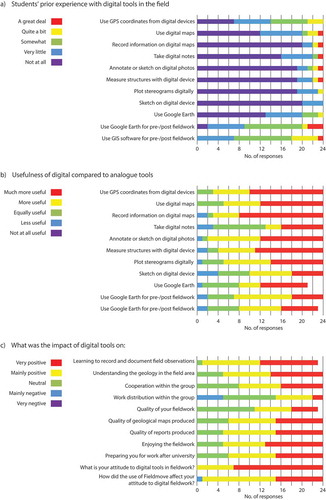
Figure 2. (a) Students’ prior experience with digital tools in the field. (b) Student assessments of the relative usefulness of digital compared to traditional tools. (c) Student assessments of the impact of digital tools.
Results
Given the small number of students participating in this study, 13 and 11 from the 2018 and 2019 cohorts, respectively, the results will primarily be reported and discussed on an aggregate level. If distinct differences between the two cohorts are present, these will be mentioned. The questionnaire was primarily designed to explore 4 themes. The first of these was the students’ prior experience with using digital tools in the field. The digital tools were broken down into 9 components (). In addition, the students were asked about their previous use of Google Earth and GIS for fieldwork. Overall, the students reported limited experience with using digital tools in the field, and somewhat more experience with using Google Earth and GIS in preparation for, and following, the fieldwork.
The second theme was student perception of the relative usefulness of digital compared to analogue tools for fieldwork (). Overall, a majority of the students participating in the survey found the digital tools to be more or much more useful than the traditional counterparts. The exception was note-taking, where a majority of the students ranked digital notes as equally or less useful than traditional notes. In open questions the students were asked about the main advantages and disadvantages of using digital tools compared to traditional analogue methods. The following advantages were mentioned by one to four respondents: ease of organizing data, integration of field data with post-fieldwork supplementary work, the possibility to zoom on the digital maps, unlimited space for data recording on digital maps, the way in which working digitally forces you to make decisions/interpretations as you record your data in the field, sketching on photos, and data visualization with stereonet. However, rapid data collection and recording were mentioned by 9 out of 24 respondents, and automatic georeferencing of the collected data was mentioned by 10 respondents.
The disadvantages mentioned by the students were, in order of number of mentions, difficulties with mapping uncertain geological boundaries and/or units (1 out of 24), software/hardware malfunction (3 out of 24), time consuming to convert and use the data in GIS program following the fieldwork (3 out of 24), time consuming to learn to use Fieldmove (5 out of 24), poor battery life (9 out of 24), and (potentially) unreliable measurements produced by Fieldmove (9 out of 24 respondents).
The third theme explored student perception of the impact of digital tools on various aspects of fieldwork (). This section can be divided into a) learning and understanding geoscience, b) teamwork, c) quality of fieldwork, maps and reports, d) motivation, and e) attitude to fieldwork. Overall, the impact of the digital tools was perceived by the respondents to be positive. The exception was the impact on group work, where a majority of the students found the impact of the digital tools to be neutral or negative, with 5 out of 24 respondents (3 in the 2018 cohort and 2 in the 2019 cohort) reporting a negative impact.
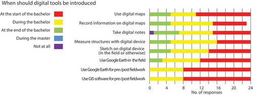
The fourth theme related to the potential use of digital tools in fieldwork during the bachelor/master study program. The students were asked when (if) the different digital tools should be introduced (). A majority of the respondents favored early introduction of digital tools for fieldwork, either at the start or during the bachelor, as opposed to at the end of the bachelor (as was done in this pilot study) or during post-graduate studies. The exception was digital note-taking, where 6 out of 24 students favored introducing this tool at the end of the undergraduate studies, with one student preferring not to introduce digital note-taking at all. The students were also asked if analogue tools ought to be introduced before digital tools. Here 6 out of 24 respondents strongly agreed, 12 respondents agreed, and 6 respondents neither agreed nor disagreed.
Figure 3. Students’ opinions on when (if) digital tools ought to be introduced during the geoscience studies.
The observations of the students during their first field encounters with Fieldmove showed that the students were quick in their uptake of the new technology, and generally positive about both the use of digital tools in general, and Fieldmove in particular. Initial frustration with Fieldmove related particularly to incidents where the software apparently switched from measuring strike and dip of structures to measuring dip and dip direction on its own accord, to the GPS turning itself off without the students noticing it (and thus logging data in the wrong place), and the lack of an option for moving notes, photos and measurements between different localities defined in Fieldmove (in the beginning, the students kept forgetting to define new localities, and ended up with disorganized notes). Making speedy geometrical measurements with a clinometer compass requires a lot of practice, and for the students, Fieldmove sped up the measuring of geometrical data considerably. Similarly, pinpointing your location on a topographic map can be time consuming and imprecise in absence of good landmarks such as buildings, roads and coastlines. Using digital maps preloaded into Fieldmove, and the maps native to the program, saved time and made the students more confident in locating themselves and their observations and measurements on the map.
The impact of Fieldmove in the graphical outputs included in the maps and reports submitted for completion of the course in 2017 (without Fieldmove) and 2018 and 2019 (with Fieldmove) were evident. However, when comparing the students’ interpretations of structures and map patterns on different scales, and of the geological history of the area across the cohorts, i.e. students’ understanding of the geology in the field areas, the overall quality of the reports and maps, did not appear to differ.
Discussion
Should digital tools be used in field teaching? It depends primarily on whether they make the students more efficient in their fieldwork, thus freeing up time for more learning activities (Whitmeyer, Citation2012), and their impact on the students in the cognitive, affective and social domains (Boyle et al., Citation2007; Mogk & Goodwin, Citation2012; Streule & Craig, Citation2016).
Getting started with Fieldmove
A concern often raised regarding the use of digital tools in fieldwork teaching, and particularly GIS, is that the complexity of the tools take time and focus from other learning goals, and makes the students frustrated (Welsh et al., Citation2013; Whitmeyer, Citation2012). In this study, the majority of the students report having none or very little experience with using digital tools in the field prior to the capstone course (; similar results are also reported by Senger & Nordmo, Citationin press). This reflects that instructors explicitly choose traditional methods for bachelor level fieldwork. Though all students report having been exposed to GIS in association with fieldwork, only 6 out of 24 students report having more than little or some such experience. This suggests that one reason the students struggle with GIS in fieldwork is simply a lack of experience with the software. This is supported anecdotally by our discussions with the students during the course; however, it is also possible that some students have ample GIS experience, just not in the context of fieldwork. Observations of the students during the first 4h field session showed that the 45 min classroom introduction by itself failed to enable the students to use Fieldmove efficiently. However, after approximately 1½h in the field spent setting up a project in Fieldmove, measuring structures, taking and annotating photos and taking digital notes with the help of instructors, the students were sufficiently confident to continue work on their own. The use of the Ipads did not seem to cause any of the groups problems (cf. Welsh et al., Citation2015). Both during the fieldwork and in the questionnaire some students specifically address the issue of efficiency. One student stated that with digital tools it is: “More efficient to gather data, and faster. Easier to transfer and use digital data for post fieldwork tasks”, another that using Fieldmove is “Better, easier and a lot faster, once you have learnt how it works.”, and a third that “This is faster and better organized [than traditional documentation of field data]”. In other words, Fieldmove appears to present the students with an interface for gathering and visualising georeferenced data in the field that is logical and intuitive enough to allow the students to become independent users in less than 3h while significantly speeding up the fieldwork.
Traditional tools vs. digital tools in the field
A majority of the students rate all but one of the digital tools as more useful than the traditional tools (). In free text answers most of the different functions of Fieldmove are mentioned in positive terms (see above). Digital note-taking was the only digital tool that was not rated as more or much more useful by a majority of the students. Taking rich field notes is something of an art. It requires meticulousness, at the same time it invites sketching, leaps of imagination and development of hypotheses on the pages of the notebook over the course of the fieldwork. The students’ skepticism towards digital note-taking highlights the strength and versatility of pencil and paper. However, when digital field notes were introduced during the field mapping course the students had already spent nearly 3 years developing traditional note-taking skills. Their preference for traditional note-taking may partly reflect that digital notes require a different style, which takes time to develop.
It is worth noting that there was one more feature that received relatively less positive reviews in the questionnaire by the students. Four out of 24 students found sketching on a digital device less useful than traditional sketching (). Sketching on a digital device requires some getting used to, and the student responses suggest that if digital sketching becomes a permanent part of the field teaching, the traditional sketching instruction provided to the bachelor students should be complemented with a digital component. The fact that some students opted to use a digital pen and some did not may have influenced the results.
The main disadvantages cited in the open questions of the questionnaire reflect either technical issues such as concerns about potentially unreliable measurements by Fieldmove, poor battery life and software malfunction, or problems associated with the transition from traditional to digital tools, i.e. learning to use the software and problems with finding a good way to illustrate uncertainty digitally when mapping boundaries and units with Fieldmove. These concerns were also noted during observation of the fieldwork.
The impact of digital tools
Besides concerns regarding time spent on learning to use digital tools, our experience is that the main concern voiced by staff is that digital tools will have a negative impact on learning and understanding geoscience, i.e. impact the cognitive domain. The digital tools may act as black boxes where important steps in data acquisition and handling are hidden from the students. For example, measuring the orientation of a planar structure using a clinometer compass requires the students to explicitly identify the strike and the dip of the plane. In Fieldmove, on the other hand, the orientation is measured simply by resting the Ipad on a planar surface and pressing the screen. Another example could be plotting geometrical data in a Stereonet manually as opposed to the automated plots in Fieldmove. However, nearly all the students (23 out of 24 respondents) report that the digital tools support learning to record and document field observations, and a majority of the students report that the digital tools contribute to a better understanding of the geology, improving the quality of both the fieldwork, the geological maps produced, and the final report (). The perceived positive effects of the digital tools reported by the students may reflect less time spent on lower order cognitive processes such as recording and describing, and more time spent on higher order cognitive processes such as applying the data to understand the regional geology and forming and testing hypotheses in the field (cf. Biggs & Tang, Citation2014). Also, the automatic and immediate connection between all data gathered by the students and high quality zoomable maps in Fieldmove may allow the students to spot patterns more easily than when plotting select data manually onto a fixed resolution topographic map, and prompt them to consider the large scale implications of their observations early on in the fieldwork. Both of these interpretations find some support in the positive emphasis the students put on the georeferencing and organizational capabilities of Fieldmove (see above). However, it is interesting to note that despite the student perception that the maps and reports were improved by the use of Fieldmove, there is no obvious improvement in the course material handed in after the introduction of Fieldmove (in 2018 and 2019) compared to prior to the introduction of Fieldmove (in 2017). An alternative interpretation is therefore that the support Fieldmove gives the students in measuring structures, plotting data, and accurately positioning their observations and measurements on the map (-s), along with the structured, chronological note-taking, provide the students with a greater sense of confidence in their work, both in the field and during post-fieldwork use of the data, translating into higher scores for the quality of their fieldwork, maps and reports. On the other hand, it is also possible that the students mistake quantity of measurements for quality, and that they to some degree are fooled by the professional look of e.g. the Stereonets produced by Fieldmove into thinking that they are doing better than they actually are. We suspect that all of the above explanations may be at play.
Other types of goals of fieldwork commonly stated are affective, such as motivation, and social, such as teamwork (Mogk & Goodwin, Citation2012). As a proxy for motivation the students were asked if the digital tools made the fieldwork more enjoyable. A majority of the student responses (19 out of 24) were positive. This was also apparent during observation of the students’ initial field experience with Fieldmove. One representative student comment regarding the use of Fieldmove was that “It’s chronological, it’s faster and I think it’s more fun”. Though some part of this could stem from the novelty of the tools, it was clear from the observations that the students felt that Fieldmove allowed them to spend less time on tedious and repetitive tasks such as measuring orientations, locating their exact position and plotting data on the map, and more time on covering ground and studying the geology. Another aspect of motivation is whether the students consider the fieldwork relevant. In the absence of relevance, there may be little motivation for the students to engage with a task (Ambrose, Bridges, DiPietro, Lovett, & Norman, Citation2010; Kember, Ho, & Hong, Citation2008). As a proxy for relevance, the students were asked if they thought the digital tools helped prepare them for work after university studies. Most of the students (18 out of 24) thought the digital tools were helpful in this respect. It thus appears that the digital tools contributed to motivate the students involved in this study, a result that mirrors findings in other studies of digital tools in fieldwork (e.g. Menking & Stewart, Citation2007, and references therein).
To assess the impact on the social aspect of the fieldwork, the students were asked about the impact of using Fieldmove on the group work. Whereas a majority of the students reported that the use of digital tools had a positive impact on the cooperation within the groups, some students (5 out of 24) also reported a negative impact on work distribution within their group (). This was borne out by the authors’ observations of the students’ fieldwork. Fieldmove combines gathering, documenting and visualizing field data in one device. Sharing one device among 2 to 4 students meant that the students huddled around the device to cooperate in the interpretation of their data and deciding on their next actions. However, in some groups it also led to a mismatch in work distribution. A tendency for one student to emerge as the “expert” on the device was observed in some groups. To maximize the group’s efficiency, the expert ended up doing most of the practical work, taking measurements, notes, photographing, sketching, and so on. The issue arose in 2018, and to address it we decided not to introduce Fieldmove to one group of students first, and then use these students as “teachers” in 2019. However, from the student responses in the 2019 questionnaire, it appears that the problem remained. A somewhat similar observation was made by Welsh et al. (Citation2015), who noted that in some groups sharing Ipads during fieldwork there were complaints about students “hogging” the device. It is our interpretation that both the positive and the negative impacts on teamwork largely had to do with the sharing of one device among several group members, not the use of the digital tools themselves. Thus, the negative effects can be addressed by supplying the students with individual devices, or, as these devices become more ubiquitous, the use of Bring Your Own Device schemes (cf. Welsh et al., Citation2018). In the context of Norway, it is interesting to note that some schools supply all pupils with an Ipad already at the start of 1st grade, at the age of 6. It is to be expected that issues stemming from unfamiliarity with tablets and limited availability will become less important over time.
We conclude that the teachers’ fear of a negative cognitive impact of digital tools in the field were unfounded. On the other hand, the students self-reported cognitive gains also failed to materialize in the final maps and reports handed in. It would thus seem that the impact of the digital tools in the cognitive domain in sum were neutral. Similarly, the reported positive and negative effects on the social domain appear to be largely unrelated to the digital tools themselves. The main impact of the digital tools found in this study were thus affective, with a pronounced positive effect on students’ perceived relevance of, and enjoyment of the fieldwork.
The future of digital tools in teaching fieldwork
This pilot study of digital tools for end-of-bachelor fieldwork has investigated the students’ experiences with Fieldmove on Ipads in field teaching, the perceived impact of these tools, and the students’ views of the role of digital tools in field teaching. Our findings indicate that the participating students take to the digital tools easily, tend to find them more useful than their traditional counterparts, perceive them as beneficial to learning and understanding, believe that they enhance the quality of their work, and enjoy using them. The positive self-reported experience of the digital tools was not accompanied by cognitive gains specifically attributable to the digital tools. However, the increased motivation and the perceived increase in relevance of fieldwork are by themselves strong arguments for introducing digital tools in field teaching. If left to the students, the digital tools would be introduced (early) during the bachelor studies and not, as was done in this case, at the end of the bachelor (). However, the students still see a role for the traditional field methods. Eighteen out of 24 respondents to the questionnaire agreed or strongly agreed that traditional field methods ought to be introduced before the digital tools. Furthermore, the majority of the student mapping groups (8 out of 14) opted to use a combination of traditional and digital field methods for their final mapping project. This suggests that the students see the educational value of the traditional tools, and in actual fieldwork, prefer to complement them with digital tools rather than replace them.
In this pilot study the students reported having next to no prior experience with digital tools for fieldwork. In the future, given the overall positive student perceptions of digital tools and the increasing availability of applications such as Fieldmove (and the smartphone version Clino) for tablets and smartphones, it seems likely that the students themselves will find and start using digital tools in the field, whether it is taught as part of the bachelor courses or not. In fact, this trend can already be discerned among our post-graduate students, who increasingly seek out and use digital tools to aid them in fieldwork.
Madsen and Rump (Citation2012) argued that a transition from using regular maps to GIS involves more than just learning to use a new tool, it affects how the users think about spatial problems. It remains an open question if and how digital tools will change the way the students think about and approach fieldwork, and what educational benefits may be lost if analogue tools are completely abandoned, and just as importantly, what may be gained by using the new tools.
Acknowledgments
The authors would like to thank the 2018/19 students who participated in the Fieldmove pilot study. We also thank Rie H. Malm for valuable comments on a draft of this manuscript, and two anonymous reviewers who helped improve the manuscript through constructive comments. This study is part of the iEarth.no initiative.
Disclosure statement
No potential conflict of interest was reported by the authors.
References
- Aanvik, M., Slang, S., Rian, A. B., & Oftedal, M. (2017). GIS - an appropriate tool for undergraduate field mapping? 33rd nordic geological winter meeting, Copenhagen. Abstract volume.
- Ambrose, S. A., Bridges, M. W., DiPietro, M., Lovett, M. C., & Norman, M. K. (2010). How learning works: Seven research-based principles for smart teaching. Wiley (San Francisco, CA).
- Biggs, J. B., & Tang, C. (2014). Teaching for quality learning at university: What the student does (4th ed.). McGraw-Hill Education (Birkshire, UK).
- Boyle, A., Maguire, S., Martin, A., Milson, C., Nash, R., Rawlinson, S., … Conchie, S. (2007). Fieldwork is good: The student perception and the affective domain. Journal of Geography in Higher Education, 31, 299–317.
- De Donatis, M., Alberti, M., Cesarini, C., Menichetti, M., & Susini, S. (2016). Open source GIS for geological field mapping: Research and teaching experience. Peer J Preprints, 4, e2258v1.
- House, P. K., Clark, R., & Kopera, J. (2013). Overcoming the momentum of anachronism. Rethinking the Fabric of Geology, 502, 103.
- Kember, D., Ho, A., & Hong, C. (2008). The importance of establishing relevance in motivating student learning. Active Learning in Higher Education, 9(3), 249–263.
- Madsen, L. M., & Rump, C. (2012). Considerations of how to study learning processes when students use GIS as an instrument for developing spatial thinking skills. Journal of Geography in Higher Education, 36, 97–116.
- Maltese, A., Harsh, J., & Jung, E. (2017). Evaluating undergraduate research experiences—development of a self-report tool. Education Sciences, 7(4), 87.
- Marra, W. A., van de Grint, L., Alberti, K., & Karssenberg, D. (2017). Using GIS in an Earth Sciences field course for quantitative exploration, data management and digital mapping. Journal of Geography in Higher Education, 41(2), 213–229.
- McCaffrey, K. J. W., Jones, R. R., Holdsworth, R. E., Wilson, R. W., Clegg, P., Imber, J., … Trinks, I. (2005). Unlocking the spatial dimension: Digital technologies and the future of geoscience field work. Journal of the Geological Society, 162, 927–938.
- Menking, K., & Stewart, M. E. (2007). Using mobile mapping to determine rates of meander migration in an undergraduate geomorphology course. Journal of Geoscience Education, 55(2), 147–151.
- Mogk, D. W., & Goodwin, C. (2012). Learning in the field: Synthesis of research on thinking and learning in the geosciences. In K. A. Kastens & C. A. Manduca (Eds.), Earth and mind II: A synthesis of research on thinking and learning in the geosciences: Geological society of america special paper 486 (pp. 131–163). Geological Society of America (Boulder, CO).
- Muir, R. J. (2015). Digital field mapping—Making the change from paper to touchscreen technology. Geology Today, 31(6), 232–236.
- Pavlis, T. L., Langford, R., Hurtado, J., & Serpa, L. (2010). Computer-based data acquisition and visualization systems in field geology: Results from 12 years of experimentation and future potential. Geosphere, 6(3), 275–294.
- Schwartz, N. (1999). Self-reports: how the questions shape the answers. American Psychologist, 54, 93–105.
- Senger, K., & Nordmo, I. (in press). Using digital field notebooks in geoscientific field learning in polar environments. Journal of Geoscience Education.
- Streule, M. J., & Craig, L. E. (2016). Social learning theories—An important design consideration for geoscience fieldwork. Journal of Geoscience Education, 64(2), 101–107.
- Swanson, M. T., & Bampton, M. (2009). Integrated digital mapping in geologic field research: An adventure-based approach to teaching new geospatial technologies in an REU site program. In Whitmeyer, S.J., Mogk, D.W., & Pyle, E.J. (Eds.), Field geology education: historical perspectives and modern approaches 461 (p. 117).
- Walker, J. D., & Black, R. A. (2000). Mapping the outcrop. Geotimes, 45(11), 28–31. Retrieved from http://www.geotimes.org/nov00/mapping.html
- Welsh, K. E., Mauchline, A. L., France, D., Powell, V., Whalley, W. B., & Park, J. (2018). Would Bring Your Own Device (BYOD) be welcomed by undergraduate students to support their learning during fieldwork? Journal of Geography in Higher Education, 42(3), 1–16.
- Welsh, K. E., Mauchline, A. L., Park, J. R., Whalley, W. B., & France, D. (2013). Enhancing fieldwork learning with technology: Practitioner’s perspectives. Journal of Geography in Higher Education, 37(3), 399–415.
- Welsh, K. E., Mauchline, A. L., Powell, V., France, D., Park, J. R., & Whalley, W. B. (2015). Student perceptions of iPads as mobile learning devices for fieldwork. Journal of Geography in Higher Education, 39(3), 450–469.
- Whitmeyer, S. J. (2012). Community mapping in geology education and research: How digital field methods empower student creation of accurate geologic maps. Geological Society of America Special Papers, 486, 171–174.