
ABSTRACT
A GIS project is an effective means of linking learning about GIS and learning with GIS, and it can enhance students’ employability. However, individual project work creates challenges that could result in failed assessment. Here we adopt a mixed-methods approach to examine how students of mixed abilities cope with GIS problems and to reveal the variety of support mechanisms they adopt. We also highlight the moral dilemmas of achieving academic success independently. We conclude that more research needs to be conducted into the way staff promote the graduate attribute of independence while still supporting their students.
Introduction
There is a tension in all geography modules between two potentially conflicting aims – helping students learn the subject guided by the staff, and allowing them to learn the subject independently from the staff. The former ensures that students understand the core of the subject as set out in the UK’s Subject Benchmarking Statement for Geography (Quality Assurance Agency, Citation2019). Achieving this understanding traditionally requires considerable input from the staff through lectures, tutorials, practical classes and reading lists. The latter – independent learning – develops the students’ self-reliance, a key employment and graduate skill (Whyatt et al., Citation2011). This tension is particularly strong in final-year modules and in Geographical Information Systems (GIS) modules. The research question here is how staff can instil independence among GIS students when their individual projects will inevitably generate problems for which they will wish to seek help. How can their help-seeking be structured so that it promotes independence rather than reinforcing their dependence on the staff? What practical measures can staff use to achieve this?
When teaching GIS within a Geography degree one needs the right balance between an education, which gives an understanding of the underlying theory, concepts and applications, and a training in the use of specific software packages (Şeremet & Chalkley, Citation2015) ideally for real-world problems (Barros, Citation2017; Bowlick et al., Citation2016). GIS education is now a mainstream component of most British undergraduate geography degree programmes and the Benchmarking Statement for Geography mandates knowledge of and skills in GIS (Walford, Citation2017). Furthermore, skills in GIS can enhance many marketable graduate attributes for students and previous studies have focused on the outcomes of GIS education, particularly for careers. Instead this study examines how students learn GIS rather than dealing with the teachers’ or employers’ views (Argles, Citation2017; Hill et al., Citation2016; Whyatt et al., Citation2011).
In practice, teaching GIS is neither easy nor intuitive (Perkins, as cited in Argles, Citation2017) and there is a tension between conceptual and applied learning. Students typically have to build their theoretical understandings and technical skills simultaneously, often through separate “lecture” and “laboratory” sessions (Bowlick et al., Citation2016). There is often a disconnection between lecture content, regarded as essential by academics but dull by students, and laboratory classes, favoured by students who consider the “hands on” experience the most valuable part of teaching (Read, Citation2010; Şeremet & Chalkley, Citation2015). There is a steep learning curve to mastering the software, with an initial emphasis on acquiring basic skills by following detailed, step-by-step instructions in “cookbooks” (Argles, Citation2017) before progressing to higher-level, problem-solving activities with reduced instructions or “scaffolding” (Carlson, Citation2008). Students therefore need to learn about GIS before they can learn with GIS. However, this “cookbook” or “buttonology” approach is dangerous because deeper learning does not necessarily come from obeying instructions. Not all students will understand what they are doing or why they are doing it, seeking merely to complete the task on time in any way possible (Argles, Citation2017). Such an approach does not foster students as independent learners.
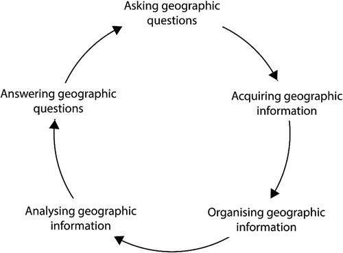
The transition from learning about GIS to learning with GIS is challenging. It can be facilitated through engagement with independent project work, where selected techniques are applied in real-world settings to solve geographical problems, and this can enhance student employability (Chen, Citation1998; DeMers et al., Citation2021; Whyatt et al., Citation2011). Many projects are group-based, letting students contribute to specific tasks, typically supervised by a leader or mentor (Bowlick et al., Citation2016). However, few students in teams get the opportunity to engage with all the stages of the geographical problem-solving cycle (), from problem definition, through data acquisition, manipulation and analysis, to data presentation and interpretation (Bearman et al., Citation2016). An individual project achieves all of this. However, working alone students may struggle with overambitious goals and unrealistic expectations of what is achievable in the time available (Read, Citation2010). Planning and time management are key but rarely taught skills for independent project work and problem solving.
Figure 1. The problem-solving cycle (Source: National Education Standards project Citation1994, p. 42).
This paper explores how students cope with the problems they inevitably encounter whilst working on their independent GIS projects. Which strategies do they use to solve their problems in the limited time available? From where do they get help? To what extent and for which type of problem do they trust this help? How do they feel about asking for help? How does the experience of a project alter their views on whether and how to seek help after graduation? There is a dearth of academic understanding of how students actually work and how they minimise the risk of failure when faced with the unavoidable technical challenges of using GIS software for an independent, student-designed project. The results should guide staff on how much help to give and in ways that promote student independence.
Module details
This paper focuses on the practical element of LEC.314, a final-year, 15-credit undergraduate optional module in GIS taken by 60 students at Lancaster University in the first term of the 2018–2019 session, before COVID-19. The module consists of 10 x 1-hour lectures and 10 x 2-hour practical classes. It builds on basic concepts and skills taught in LEC.211, a 15-credit core module in which the “buttonology” approach prevails because of large-class teaching and the need to learn basic GIS skills. In LEC.314 students are introduced to advanced forms of spatial analysis and are required to download and manipulate their spatial data rather than being given it already processed and ready to use. The level of instruction, or scaffolding, in LEC.314 is much lower than in LEC.211, with students encouraged to experiment with the software without detailed instructions.
The module is assessed through a combination of examinations (50%) and an individual project (50%). The latter is an advanced, student-designed project that encompasses the whole problem-solving cycle (). The project assessment is introduced through a lecture in week 6 and the final 3 practical classes of term are dedicated entirely to project support. Students submit a 2000-word, fully illustrated project report after the four-week Christmas vacation. The project brief is deliberately open-ended, giving the students every opportunity to focus on a real-world geographical problem and geographical area of interest to them: “Use GIS to conduct research on a topic of your own choice for an area of your own choice using appropriate data and methods”.
This is a challenge, both in terms of defining the aims and scope of the project (neither too simplistic nor too complex given time constraints), and in terms of the technical challenges of acquiring, manipulating and analysing spatial data within a GIS environment. Although the staff provide initial feedback on project ideas through short individual meetings, students have to work independently through all the stages of the problem-solving cycle (). The software is complex, and every stage will throw up problems. Failing to solve these problems on time could lead to the student failing the module because the project comprises 50% of the overall assessment, which could endanger their hoped-for degree class. The module runs in parallel with the final stages of their core 30-credit dissertation and other modules with similar coursework deadlines. The time pressures on students are very real and the stakes are high. The temptation is for the teaching staff to be really helpful and answer every query from every student. Yet over-helpfulness reduces the students’ independent problem-solving abilities.
Methodology
Studying how students seek help during an independent, time-constrained project is necessarily complex. There are several sources of help that can be accessed at different times and in different ways. How do students choose which sources to use and when? Which sources do they trust? Are they morally conflicted by seeking help or do “ends justify help-seeking means”? This study of the hitherto “black box” of how students interact with each other and staff aims to deconstruct how students actually learn GIS. Previous studies of GIS education have not focused on how students obtain help with the inevitable GIS problems and how they perceive the relative value of sources of help – only they know how they do this. Therefore we require a mixed-methods approach that collects quantitative and qualitative information on how and why the students behave in the ways they do. A mixed-methods approach was successfully used by Clark and Jasaw (Citation2014) when they studied the varied actions, perceptions and responses of the staff, students and communities to university projects based in rural communities. Lessons learned from that study informed the methodology used in this project and have been adapted for a GIS context. The methods collect this information in several ways. Some will come from the staff who interact with the students during the course of the project. Some can be derived from existing university feedback and course-review mechanisms. Some can be gained from observing the students while they work on their projects. Finally, deeper insights can be gained through interviews with the students to explore their motives, actions and intentions and the longer-term gains the students identified from the project. Such a mixed-methods approach with qualitative elements is relatively common in the study of GIS teaching and learning (Bowlick et al., Citation2016; Madsen & Nielsen, Citation2013; Madsen & Rump, Citation2012), however, this study is unique in the number of methods used and the independent nature of the observer.
The researchers involved are: (i) the authors (JDW and GD) who have run this GIS module over many years and who gave the lectures and supervised the practical classes that preceded the project and gave on-going student support during it; and (ii) an independent researcher (the author GC), a geographer from the Department who had retired ten years before this research was conducted, was not known to the students and had no practical experience of using GIS. Five sources of information were used.
Reflections by the two staff who run the module (JDW and GD) on the types of questions and their frequency that they have been asked during the project-support sessions in 2018–19 and previous years.
Observations by the independent researcher (GC) of 32 students during three project-support sessions in 2018–19. He noted the students’ interactions with staff and fellow students during the sessions and the use of online help resources. He could not monitor the content of the interactions and the results are aggregated and quantitative. This captures only the scale of the students’ interactions during the project-support sessions: interactions outside of these or via social media remain unknown.
The critical reflections from 25 anonymised students on their project experiences, collected by the module convenor (JDW) in 2016–17 and 2018–19.
The students’ free-text, anonymous comments in the module’s standard annual university Evaluation Report in 2018–19, which had a 50% response rate.
Interviews conducted in January 2019 by the independent researcher (GC) with 20 students after their projects had been submitted in 2018–19 but before the marks were known to the students or GC. The interviews were recorded and varied in length from 13 to 20 minutes. When quoted, the students are referred to by a number. The recordings will be deleted after the project has been completed.
The methods used were approved by the University when they awarded a small grant to the principal researcher (JDW) to meet the minor costs of this research which aims to enhance the University’s understanding of its GIS teaching beyond what the standard course-evaluation methods were telling. Here we summarise the University’s ethical safeguards which were used in this research. The students were made aware at the start of the module of the purpose and nature of the research and the role in it of GC. Participation in all the data-collection methods was always voluntary and open equally to all. Consent was always sought and given freely, and the students knew that they could review, amend or withdraw anything they had said or written. The responses are given either with the students anonymised (the interviews, reflections and evaluations) or in an aggregated, numerical form in which no individual could be identified (the observations). When anonymised, the students are referred to by a number and only the independent researcher (GC) knows their real names.
Results
To understand how the students coped with and learned from the difficulties during their GIS project, the analysis of the results is presented through eight themes. These are: project definition; practical difficulties encountered; tactics for overcoming difficulties; rationale for choice of tactics; success of tactics; tactics rejected; lessons learned; and the broader effects of completing this GIS project.
By which criteria did the students define their GIS project’s topic, and how and why did they change their topic during the project period?
The 20 students interviewed gave between one and three reasons for their choice of topic, and mostly more than one. Most of the reasons were aimed at making the project easier in some way.
11 students based it in the university area or their home area to relate their GIS analysis to a familiar real-world location.
9 said it was a topic that paralleled data, GIS functions or topics used in previous practical classes in the LEC.314 module.
9 students chose the topic because it seemed feasible, or did not need too much data or even because it was seen as easy.
8 said it was a topic in which they were personally interested and 4 said it was a topic about which they felt strongly.
5 said it was a topic that linked to other modules in their degree scheme or their dissertation.
The reasons are clearly overlapping – feasible, easy, linked to a practical class or a topic they knew about from another module. Feasibility (and hence more likely to get a good mark) is rational and in line with the advice from the staff not to over-complicate it. Their criteria for topic selection all focus on minimising the risk of failure and the need for help.
Each student was then asked whether their topic had evolved after their initial one-to-one project meeting with JDW or GD. Only three students said that there had been few significant changes.
7 narrowed the project topic to make the project more feasible.
3 narrowed the study area to make the project more feasible.
2 narrowed the topic so that the computation could be done on their laptop (presumably allowing work away from the university).
2 chose different data and 1 chose a new study area specifically to get data.
Two completely changed the topic, the original one not being feasible despite smaller changes. One student said they had expanded their project as it had gone along and another mused whether they should have done a more ambitious project. Again risk-minimisation tactics are evident.
The difficulties the students encountered during their project
The staff reported the most common questions they were asked by worried students during the three project-support sessions.
How to acquire the relevant spatial data and format it correctly. All the students had such problems, including those happy with the topic and how to tackle it.
How to plan the analysis of the data to achieve the objective. This group was mostly those students who were unclear on what their topic was and how tackle it. The lack of clarity was often about how the project had been defined or how it might be achieved.
Technical questions, including why an output was not in the form intended.
Student 1 summed up the major difficulty experienced by the interviewees: “I think that like 70% of the time I spent on my project was on data collection and how to make the data appear the way I wanted and how to connect them and georeference them”. In the interviews eight students said that getting the right data they needed for their topic was a big problem. Six said that a major difficulty was getting the data they had collected into the form that they wanted so the data could all be analysed together in ArcGIS. In their course review Student 2 wrote that initially “I was just clicking away aimlessly without knowing what I was really doing”. A very wide range of other technical issues around using the GIS software correctly or to achieve a desired outcome was raised as problematic, each by a single student.
How did the students deal with these difficulties?
During the project-support sessions the researcher, sited behind a small group of 10–12 students at their computers, recorded how the students actually behaved, by observing them during these sessions.
During the 3 x 2-hour project support sessions the 32 students who were observed (10–12 per session) asked questions of the staff 95 times, of a near-neighbour student 51 times, used notes or a handout 42 times, accessed a website 20 times (mostly a GIS forum site or a YouTube “how to” video), and consulted a book or journal once.
The number of times an individual student sought help from one of the above sources ranged from 2 to 16 times during a single project-support session.
The length of time given by the staff member to answering a student’s question ranged from under one minute to 15 minutes.
The number of different sources of help that an individual student used during a single project-support session ranged from 1 to 4.
Out of the 32 students observed, only 4 never asked for help from a member of staff, 9 never asked for help from a neighbouring student and 16 never consulted a website.
From these quantitative observations of student behaviour it is clear that the students varied greatly in how often they sought help – from the unconfident to the highly but not wholly self-reliant. The students varied greatly in the number of sources of help they used. Help from staff and to a lesser extent from other students was the most used, because it was easily and quickly accessible and particularly the staff were trusted to sort out problems swiftly and accurately. The students’ behaviour is highly rational for ensuring progress – accurate solutions quickly achieved.
The 20 students interviewed were asked how they dealt with the difficulties they met during their project.
15 students said that they used online sources to solve their problems – Google, YouTube, ESRI ArcGIS help, Stack Exchange, and various forums and online tutorials. This is proportionately only a little more than was seen during the project-support sessions, despite including periods outside the sessions.
13 students said they used other students as a source of help. This is under-reported as students could contact each other outside of the sessions and quick chats in the sessions were forgotten or not registered as being “help”.
10 students said they asked the staff for help. This is a major under-reporting given the researcher’s observations (see above).
9 students used handouts or previous projects on the LEC.314 Moodle site.
9 students noted that they solved their problems by trial-and-error, persistence or teaching themselves something new.
2 students did as much of the work as possible during the project-support sessions where staff were on hand to answer questions.
All the students used more than one source of help, though some more than others. They often had a preferred sequence of using the sources. The most common sequence of external sources was – online sources, Moodle materials (the University’s Virtual Learning Environment), other students and finally the staff. But for some, the staff were their first choice and for others the Moodle materials. This is studied further in the following section.
Why did the students choose to try and resolve these difficulties in these ways?
In the interviews the students had very different perceptions of the effectiveness, ease of use and desirability of the different sources of help, which some students used extensively and others little.
A few decided to use QGIS software rather than ArcGIS to broaden their experience of software and enhance their employability. They had to rely on online sources for help as all the practical handouts for the module were written specifically for ArcGIS. No other sources could help them except the other students using QGIS, who formed a peer-support group.
For students using ArcGIS software, the advantages of online sources of help were described in the interviews as follows: always available wherever you were; vast; often clear and with close parallels to the student’s problem; and good for straightforward technical problems.
The two biggest disadvantages of online sources were, first, that they were so vast that it was hard to find quickly the help required and, second, the requirement to use exact and specific search terms – and the students doubted they knew the right terms. Other disadvantages mentioned in the interviews were clear but specific to individual students:
Too much technical language to be comprehensible (Student 3);
Too complex to search (Student 4);
Its usefulness was variable and could not be relied on (Student 5);
It was not specific enough; a person asked for help could see what was on your screen and so give a better focused answer for your problem (Student 6).
The advantages of online sources were most strongly emphasised by those more confident in using computers – Student 7 said, “I swear by them” – and the disadvantages by those who were not. The latter tended to be those who preferred dealing with people. Student 8 really was afraid of “breaking something” and wanted personal reassurance, so they looked online last of all.
Help from other students was favoured because they were available and would usually try to help. They were seen as most helpful on smaller technical issues. Their value was seen as variable in quality. However, Student 12 had believed that their project was impossible, but it was saved by another student who showed them how it could proceed. This is confirmed by the observations the researcher made on students’ behaviour during the practical support sessions.
The staff were always seen as helpful, accurate and wholly reliable. They were “fair game” for requests for help in the support sessions. As Student 9 said, “I did ask [the staff] for a lot of help in the practicals – maybe too much at times”. Student 10 did as much as possible in these sessions to get the best access to the staff. This is confirmed by the staff’s accounts of the kinds of questions they are asked during the project support sessions.
Lancaster GIS handouts on the Virtual Learning Environment were well regarded as a source of help (easily available and reliable), particularly when the topic had been chosen and structured to be similar to an earlier practical done in LEC.314, as some students did.
The interviews added a strong moral (as opposed to a pragmatic) dimension to the students’ help-seeking – they knew they ought to be working on their own to solve the problem.
Student 9 said, “I didn’t want to feel as though I was relying on them [the staff] too much. I wanted to build the project myself. I like trying to work it out myself […] a sense of achievement when you get it [after] seven or eight attempts.”
“That sort of independence; that ability to solve it yourself, yeah”, said Student 11, who taught themself QGIS. In the students’ official module-review responses in 2018–9 (completed by 31 of the 62 students) the most frequent comment (by 11 of them) was that the experience of doing the project had improved their senses of self-worth, self-belief, confidence and pride in their work.
Clearly there is a preference, even a pressure, to be independent – some students believe that this is what the project is meant to be, and independence is good in itself, avoiding the loss of face by asking simple questions you feel (and the staff might feel) you should have been able to solve yourself. For several students, being independent is part of their identity. Yet there is a tension (shown in the quotations) between the desire for and value of independence and the need to finish a good project in the time available. Some students asked for staff help last of all: others asked them first and saved time.
How successful were these problem-solving methods?
The predominant answer in the interviews was that these sources of help did solve the problems satisfactorily. The most interesting aspects of the answers were the ways in which this satisfaction was qualified. Student 13 said, “I did feel a bit guilty about asking so many questions [of the staff]”. Student 15 noted how some students could help them and others could not. Student 5 was critical of online sources: some were helpful, some not. Student 9 said that online sources and students were helpful only if their problem had come up before. The students were not uncritical of the sources of help.
Why were other possible problem-solving methods rejected?
According to the interviews, each source of help had students who deliberately used it sparingly or not at all, for various reasons.
Online sources were not used by Student 3 because they were not feasible for them or were not understandable. Student 20 found YouTube videos unhelpful for their specific problems. Student 10 did not use online sources or forums at all. Student 14 said, “After a couple of times I realised it was best not to Google. It sort of blows your mind a little bit.” All these replies suggest a prior deep-seated lack of confidence in online sources for reasons that are sometimes specific but may also be generally technophobic. This strongly contrasts with those students who were happy and confident to use them.
Student 3 did not consult fellow students as they were not helpful, while Student 16 did not like to ask other students for help because they stressed them out since they talked about their successes.
The staff were not asked for help for various reasons. Student 7 said “I usually try and avoid ask questions, not because they are difficult to approach, but just because it’s much more satisfying to do it yourself”. “If I had got to that point where I was completely stuck, I would have [asked the staff].” Student 13 said “There was a couple of times where I avoided asking Duncan or Gemma purely because I had pestered them so much, them being overloaded with work. […] If I had not been able to find it myself, I would have asked them eventually.” Similarly, Student 11 said that the staff were really busy – a big class: “I did not want to waste their time with trivial problems like that”.
Clearly the students tempered their faith in the staff’s generosity of time and their subject knowledge with a concern not to overload them or exploit their pastoral ethos. The duty of seeing yourself as autonomous could sometimes outweigh the ease and time-saving of asking staff for help.
What lessons were learned by the students for how to solve GIS problems and how they would solve GIS problems after graduation?
All but one of the students could envisage doing another GIS project. Nonetheless, they identified a wide range of lessons from their LEC.314 project beyond skills in ArcGIS software, GIS itself, finding data, and data and file handling. Student 13 and Student 6 said that they had learned the mindset of independent learning (“You are much more likely to remember the issues if you do it yourself”). Student 6 also learned the value of patience. Student 15 focused on how their skills improved over time. Student 17 acquired an enhanced belief in the power of trial and error. Confidence was at the heart of Student 12ʹs learning. “Like, I feel so much more confident now […] I feel like I am in a better position to know where to start if I were put into a job circumstance. It forces you to click out of ‘press this, press that’; it forces you to think about it.” As Student 3 put it, “The more that I went through the project, the more I intuitively knew what to do.” Their fluency analogy was with learning to drive a car. Student 14 had learned to experiment with the software with a more can-do mindset and Student 18 said, “It’s probably simpler than you think”. Student 7 understood the rest of the module better because of the project. Student 11 stressed the importance of more planning. Student 5 neatly summarised the students’ types of wider learning and their inter-connections. “I got a much better understanding of GIS. Actually solving problems yourself makes you think about it rather than just following the instructions. It is mainly the confidence that once you have done one and you have come across problems and you’ve solved it yourself and you kind of think, well, now I know where to look […]. By the end I had kind of found quite a good source so that would be helpful in the future.”
Their “lessons learned” are diverse, affecting all the stages of doing a project successfully – planning, data collection and manipulation, online sources of help, critical thinking, software skills. Also there were the personal qualities and graduate attributes needed for solving problems – persistence, self-confidence, patience, trial and error, and the practical value of independent problem solving.
When asked how differently they would tackle a future GIS project after graduation, many changes were suggested based on what had worked less well in the LEC.314 project, while others were necessary changes because university staff were no longer there to give help – a more tightly defined topic, checking at the start that the right data were available, reading previous comparable projects for guidance, more early planning, and identifying from the start sources of help. Seventeen of the 20 students interviewed would seek help in a future project from online sources, that is, by trying to solve the problem themselves. Sixteen would try to find people (colleagues, friends or experts) from whom help could be sought. All but one of the students noted more than one intended source of help. Where two sources of help were given, online sources were the first mentioned by 15 students and colleagues by three.
The emphasis on self-help (which is what a reliance on online sources implies) is partly a matter of necessity – no-one else would be prepared to help as much as the staff had. It was also a growing realisation among most students of the potential of online sources. This was among both the original supporters of online sources and through a growing preference for these by initially sceptical but partly won-over students.
Seeking help from new work colleagues was realised by some students as feasible but potentially problematic. Student 11 said “Conduct yourself professionally when asking for support. Show an element of sophistication in what you are doing so they are more inclined to help”. Similarly Student 9 said, “You would have to show you had really really tried working on it yourself [before asking for help]”.
The broader effects of doing this independent, time-limited GIS project
The results here are based on the course-evaluation data and they record the students’ ranked views on the benefits from the module and project.
19 students believed that they are now better GIS problem-solvers.
17 students said they could now add GIS skills and competence to their CV.
16 students felt that the experience of doing the project had improved their senses of self-worth, self-belief, confidence or pride in one’s work.
14 students said they enjoyed the experience of doing research and the freedom it gave.
12 students said they valued the support of trusted people and materials.
9 students thought the project made sense of the practicals earlier in the module.
8 students said they now recognised the importance of persistence and trial-and-error in achieving one’s aims.
3 students said they had come to understand the true value of GIS approaches and techniques in general.
In their course review Student 2 wrote, “I am proud that I was able to use GIS by myself and use it in a real-world context”, and Student 19 wrote that they had “greater confidence, that they could question and understand GIS and data” and “I would like to pursue a career specifically in GIS”.
Collectively these perceptions show that the module had induced the changes in the students that the module’s aims and objectives aspired to – enhanced problem solving and self-confidence, reliance on online sources, trusting colleagues and one’s own abilities, and fuller GIS technical skills.
Discussion
Introduction
This study, like others, confirms the wide-ranging benefits of independent project-based learning in GIS (Bowlick et al., Citation2016; Chen, Citation1998; Şeremet & Chalkley, Citation2015). The students featured in this study each engaged in all aspects of the problem-solving cycle from project definition to critical interpretation of its outputs (). How did they cope with “going solo”? Given that “independence” is a key graduate attribute (Hill et al., Citation2016; Quality Assurance Agency, Citation2019) how did they balance their inevitable need for help to prevent assessment failure with their laudable desire for independence. We shall now consider: (i) what help (conceptual and technical) was required, and when, and (ii) which help resources were utilised. Finally, we shall reflect on what we have learnt from this study, and how we can use this to better support our students achieve real independence.
What help was required?
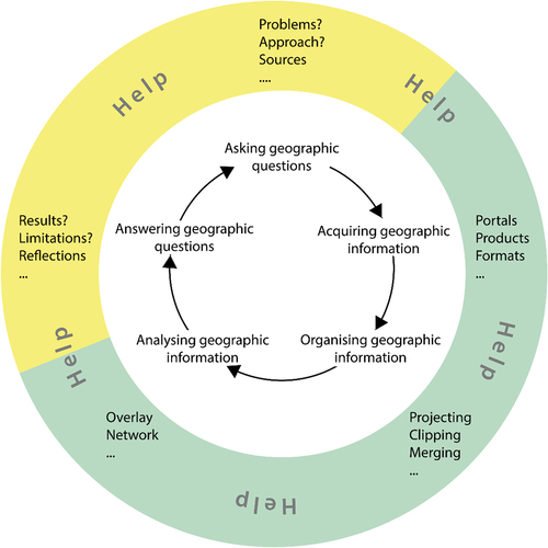
The students had already largely learned to use GIS by following instructions designed by the staff for a pre-defined geographical problem. shows the problem-definition cycle, this time annotated to illustrate the GIS tasks where help will be needed. Some of these are conceptual – translating a real-world problem into GIS operations – whilst others are technical – manipulating data and utilising them for spatial analysis. The end of the cycle lets the student reflect on how good a critical spatial thinker they have become (Bearman et al., Citation2016).
Figure 2. The original problem-solving cycle annotated for the stages in a GIS project where tasks and problems occur. Yellow and green colours indicate where more conceptual and more technical help are given, respectively.
The GIS staff (authors JDW and GD) noted that some of their students were excited by the challenge, one of the reasons that they chose the module. Others were more apprehensive. This was reflected, to some extent, by the level of ambition of the individual projects. Some projects were ambitious – complex real-world problems using sophisticated techniques. Others were less so – predictable topics, less conceptual translation and basic techniques. Some students decided to take risks and embrace the project and its freedoms: others chose not to do so (Chen, Citation1998; Madsen & Rump, Citation2012). Only some of these students will go on to evaluate critically what they have achieved and become critical spatial thinkers (Bearman et al., Citation2016).
Which help resources were utilised?
summarises the students’ views of the characteristics of the sources of help they accessed to deal with problems and minimise the risk of assessment failure.
Table 1. Sources and characteristics of help used by students during individual project work.
The teaching staff were readily accessible, highly accurate, speedy, flexible, specific and reassuring, but they were the one source of help that would be unavailable after university, and their repeated use (tempting) might be perceived to reflect badly on the student although this was false. The students knew they were the best source of help for the project and the worst for promoting their independence. They were the best help for struggling and less confident students who needed personal reassurance (Bowlick et al., Citation2016; Chen, Citation1998). Fellow students were also accessible in class or via social media but were seen as less accurate and could be intimidating. The course resources on the VLE (Moodle) were seen to be accurate, accessible and trustworthy, however, they could not always be adapted to the specific circumstances of the individual project.
Some students accessed the help pages in the ArcGIS software, encouraged by the teaching staff, but not actively promoted in earlier practical sessions. Students found the advice to be highly accurate and highly trustworthy, but some struggled to translate the general advice for their project. They disliked having to search large volumes of online help unsure whether it was relevant, but perhaps because they were unsure what they needed (Rickles et al., Citation2017). Others have commented on how users turn to the Internet to find a solution in preference to the software’s help pages (Martin et al., Citation2005), but this too was seen as time-consuming and at best hit-and-miss. Some students chose to search for video tutorials for particular tools. Such material is highly accessible but there are issues of specificity and accuracy since anyone can upload material.
Finally, some students engaged with social Q&A sites such as GIS StackExchange (https://gis.stackexchange.com), which provide a forum for knowledge seekers (users of software asking for support) to interact with knowledge providers (other users, more knowledgeable about the topic) in an open environment (Vasilescu et al., Citation2014). This was the only source of support for students who chose to conduct their analysis using QGIS. This can be a highly accurate and highly accessible form of support, however, since StackExchange sites encourage participants to “ask well-formed questions, leading to well-formed answers” this can be problematic for students asking imprecise questions.
Lessons learned
Finally, we reflect on what we have learnt from this study, and how we can use this to better support our students in the future.
The individual GIS project exposes students to all aspects of the geographical problem-solving cycle and the conceptual and technical challenges this brings. The students clearly understand the benefits of completing the project, transitioning from learning about GIS to learning with GIS, but they approach the project in different ways depending on their attitudes to risk and their confidence in their own abilities to use complex software to complete tasks with minimal instruction and to a tight timetable. The students experience a real tension between the need to achieve a good grade and the need to work (and to be seen to work) independently, since this is where the main learning opportunity arises for employment after graduation.
A few students minimise problems, the risk of failure and the need for help by choosing simple projects that mirror topics covered in class, making the most of pre-existing handouts and in-person interactions with staff. They struggle to move beyond the buttonology approach (one of the aims of the project), are over-reliant on accessible and authoritative sources of help, notably the teaching staff, and they are not always aware of the strengths and weaknesses of their resulting analysis. Their project may get a pass mark but it is questionable whether these students have gained many new skills from completing the project or have become critical spatial thinkers (Bearman et al., Citation2016). The risk of failure was too high for them to work more independently.
However, the majority of the students rose to the challenge of the individual GIS project, becoming, in their words, increasingly independent as the project progressed, less reliant on more immediate and knowledgeable sources of help such as the teaching staff and more engaged with software help pages, online video clips and Q&A forums.
Some of these students had the confidence from an early stage to explore the software, to take risks, to learn from their mistakes and thereby gain a deeper understanding of the capabilities of the software in the context of their specific geographical problems (Chen, Citation1998; Madsen & Rump, Citation2012). This was most apparent for those who chose to use QGIS for their project work despite having been taught up to that point in ArcGIS.
Reflections and future research
The benefits of conducting project work are well documented and are recognised in the Subject Benchmarking Statement for Geography (Quality Assurance Agency, Citation2019), contributing to the development of intellectual and subject specific skills, generic skills and other personal attributes. This study has also demonstrated the wider importance of project work in relation to “graduate attributes” which Wong et al. (Citation2021) thematically group into categories of self-awareness and lifelong learning, employability and professional development, global citizenship & engagement and academic & research literacy. Our study has shown that completing the project has improved some students’ sense of self-worth, self-belief, confidence, pride and professionalism in their work, using “skills and resources at their disposal” to “master their personal effectiveness and achieve their goals” (Wong et al., Citation2021). Inevitably the students will need help with their projects, but in a way that reinforces the development of independence for careers after graduation. In the future, students should be encouraged to capture and then reflect upon the elements of the project that have helped develop this independence. This might be achieved through conducing pre– and post- project audits of GIS skills and broader graduate attributes and writing a reflective account of the experience based on learning journal entries made over the duration of the project.
What practical measures might we introduce to achieve this and so encourage more students to go solo more fully and quickly? The staff could reduce the level of scaffolding (instruction) in the laboratory sessions that the students complete before their projects, so as to encourage more independent learning at an earlier stage. Alternatively, current levels of scaffolding could be maintained but supplemented by more free-form exercises in which students apply the techniques they have learned independent of written instruction. The challenge here is to avoid “spoon feeding” the students and to let them learn through experimentation and trial and error, though this is stressful (Chen, Citation1998). There is also scope to encourage more active use of online resources (e.g. help systems, tutorials, knowledge forums) in the laboratory sessions, teaching students how to frame their questions in the correct terms – a major problem students found with online sources (Rickles et al., Citation2017). However, it is up to the individual student to decide on the best strategy to complete their project, balancing the level of risk and reward associated with time spent on this coursework against time spent completing coursework for other modules. For some students, simply getting through the project is a satisfactory end point, whilst for others, the need to deliver a piece of high-quality independent coursework is all-consuming. The pressures to go solo are student specific.
Conclusions
This study has highlighted some of the challenges that students face when completing individual GIS project work and their strategies for dealing with these challenges. The GIS project presents a risk to all students, although the risk is higher for those less computer literate or less confident in using the software without detailed instructions. These students minimise risk by adapting detailed “cookbook” instructions from earlier practical sessions and asking many questions in project support sessions, with teaching staff providing accurate, timely and precise answers to their queries. In contrast, the risk is very much lower for the more computer literate students, happy to learn through trial and error and to work out solutions through various online sources. The majority of students fall between these extremes, and this study has shown clear evidence of students becoming more confident and independent in their abilities as their projects progress, not only through developing skills in problem solving and project management, but also through development of critical self-awareness, such as self-directedness, self-regulation, self-reflection and self-improvement (Wong et al., Citation2021). Many students felt duty-bound to ask staff for help only as a last resort, preferring to find solutions themselves, accepting, perhaps, that they were unlikely to receive such knowledgeable, accessible and specific support in the workplace. There are ways, noted above, in which staff can and should use to increase trust in online sources among sceptical students and so convert themselves from first-resort sources of help to last-resort ones.
This research has highlighted both the many stresses on the students doing this highly technical project under time pressure and also the range of coping and risk-minimising strategies adopted to solve GIS problems. It has also revealed the relative levels of trust that students place in face-to-face and online sources of help at the onset of the project, and how levels of trust in online sources are measurably higher at the end of the project. Strikingly, the research reveals the tension between “independence” as a moral imperative and “fear of failure” in how students choose to obtain the help they need and the many personal and behavioural changes induced in the students by having completed the project.
In conclusion, this study has highlighted five key underlying themes. Firstly, a student’s initial self confidence in computer and online skills is important, as is the degree to which these improve during the project. Secondly, a student’s way of getting help is affected by their relative trust in the various sources of help available, particularly online sources, staff and students. Thirdly, the students’ comments record the development during the project of their unassessed personal qualities that are vital for problem-solving in GIS (self-confidence, persistence, a belief in the efficacy of trial-and-error methods, and a can-do mindset). Fourthly, staff need to note the moral weight many students attach to independence of action and performance over more personal ways of getting answers to one’s questions during GIS problem-solving. Fifthly, the graduate attribute of independence will be effectively developed widely only if both the students and the staff recognise its importance and work together to achieve it. Each student has unique reasons for taking the module and unique approaches to navigating the challenges the individual project presents. Its benefits extend far beyond a better understanding of GIS.
Acknowledgments
This study was funded by Lancaster University Faculty of Science Technology Teaching Development Grant. The authors would like to thank the 20 anonymous students who were interviewed as part of this study and other students who have provided critical reflections with their project write-ups in recent years. They would also like to thank the 2 reviewers for their constructive comments.
Disclosure statement
No potential conflict of interest was reported by the author(s).
References
- Argles, T. (2017). Teaching practical science online using GIS: A cautionary tale of coping strategies. Journal of Geography in Higher Education, 41(3), 341–352. https://doi.org/10.1080/03098265.2017.1315531
- Barros, J. (2017). Introducing GIS across levels: Designing for diversity. Journal of Geography in Higher Education, 41(3), 353–367. https://doi.org/10.1080/03098265.2017.1331207
- Bearman, N., Jones, N., André, I., Herculano, A., & DeMers, M. (2016). The future role of GIS education in creating critical spatial thinkers. Journal of Geography in Higher Education, 40(3), 394–408. https://doi.org/10.1080/03098265.2016.1144729
- Bowlick, F. J., Bednarz, S. W., & Goldberg, D. W. (2016). Student Learning in an Introductory GIS Course: Using a Project-Based Approach. Transactions in GIS, 20(2), 182–202. https://doi.org/10.1111/tgis.12146
- Carlson, T. (2008). Scaffolding Instruction in a University-level GIS Course. Journal of Planning Education and Research, 28(2), 258–262. https://doi.org/10.1177/0739456X08323770
- Chen, X. M. (1998). Integrating GIS Education with Training: A Project-Oriented Approach. Journal of Geography, 97(6), 261–268. https://doi.org/10.1080/00221349808978843
- Clark, G., & Jasaw, G. (2014). Evaluating project-work using triangulation: Lessons from communities in northern Ghana. Journal of Geography in Higher Education, 38(4), 511–524. https://doi.org/10.1080/03098265.2014.936311
- DeMers, M. N., Kerski, J. J., & Sroka, C. J. (2021). The Teachers Teaching Teachers GIS Institute: Assessing the Effectiveness of a GIS Professional Development Institute. Annals of the American Association of Geographers, 111(4), 1160–1182. https://doi.org/10.1080/24694452.2020.1799745
- Hill, J., Walkington, H., & France, D. (2016). Graduate Attributes: Implications for Higher Education Practice and Policy. Journal of Geography in Higher Education, 40(2), 155–163. https://doi.org/10.1080/03098265.2016.1154932
- Madsen, L. M., & Nielsen, T. T. (2013). Learning to do geography? University students posing questions in GIS laboratory exercises. Norsk Geografisk Tidsskrift, 67(3), 157–161. https://doi.org/10.1080/00291951.2013.803259
- Madsen, L. M., & Rump, C. (2012). Considerations of How to Study Learning Processes when Students use GIS as an Instrument for Developing Spatial Thinking Skills. Journal of Geography in Higher Education, 36(1), 97–116. https://doi.org/10.1080/03098265.2011.576336
- Martin, A. P., Ivory, M. Y., Slabosky, B., & Megraw, R., 2005. How Helpful is Help? Use and Satisfaction with User Assistance. Paper presented at the 3rd International Conference on Universal Access in Human-Computer Interaction, July 22-27, Las Vegas, NV, USA.
- National Education Standards. (1994). National Education Standards Project 1994: Geography for life. National Geographic Society Committee on Research and Exploration.
- Quality Assurance Agency, 2019. Subject Benchmark Statement for Geography. https://www.qaa.ac.uk/docs/qaa/subject-benchmark-statements. 18/08/2021
- Read, J. M. (2010). Teaching Introductory Geographic Information Systems through Problem-based Learning and Public Scholarship. Journal of Geography in Higher Education, 34(3), 379–399. https://doi.org/10.1080/03098265.2010.490909
- Rickles, P., Ellul, C., & Haklay, M. (2017). A suggested framework and guidelines for learning GIS in interdisciplinary research. Geo: Geography and Environment, 4(2), e00046. doi:10.1080/03098265.2017.1331210.
- Şeremet, M., & Chalkley, B. (2015). Student perspectives on the teaching of geographical information systems (GIS) in geography degrees. Journal of Geography in Higher Education, 39(1), 18–36. https://doi.org/10.1080/03098265.2014.963795
- Vasilescu, B., Serebrenik, A., Devanbu, P., & Filkov, V., 2014. How Social Media Sites are Changing Knowledge Sharing in Open-Source Software Communities. Proceedings of the 17thACM Conference on Computer Supported Cooperative Work and Social Computing, February 15-19, 2014, Baltimore, MD, USA.
- Walford, N. (2017). The changing nature of GIS and the provision of formal GIS education in the UK: A case study. Journal of Geography in Higher Education, 41(3), 310–326. https://doi.org/10.1080/03098265.2017.1315532
- Whyatt, J. D., Clark, G., & Davies, G. (2011). Teaching GIS in Geography Degrees: A Critical Reassessment of Vocationalism. Journal of Geography in Higher Education, 35(2), 233–244. https://doi.org/10.1080/03098265.2010.524198
- Wong, B., Chiu, Y.-L. T., Copsey-Blake, M., & Nikolopoulou, M. (2021). A mapping of graduate attributes: What can we expect from UK university students? Higher Education Research and Development, 1–16. https://doi.org/10.1080/07294360.2021.1882405