
ABSTRACT
Recruiting undergraduate students is a significant challenge for undergraduate geography programs. Few students have robust exposure to geography in secondary school and the major has low name recognition for entering first year students. In fact, geography is often a “found” major on many campuses with students coming to the major after a general education course. But, does it need to be this way? Can geography programs take a more proactive role in building a pipeline of prospective students that is not solely tied to supporting AP Human geography teachers? In this paper, we describe an alternative path for university departments to build strong recruiting pathways, sharing the successes and challenges of building the connections and the learning advantages that students gain through early exposure to geospatial technologies. We focus on the Geospatial Semester, a dual enrollment program between James Madison University and participating school districts in Virginia (and beyond) that began in 2005. We share how departments can build a successful partnership with high schools and the process of sustaining such a program within a university setting. We will also describe the research we have done on the learning gains the Geospatial Semester provides to participating students and how extended use of geospatial technology bolters students’ spatial thinking skills.
Introduction
Enrollments in undergraduate geography majors have been a point of concern for programs across the United States (cf. Kaplan, Citation2019). Prospective majors’ exposure to geography in primary and secondary schools is uneven, and often the social studies curriculum is dominated by history. Not surprisingly, recent NAEP results point to weak performance in geography (Solem et al., Citation2021) at all levels. Despite the widespread offering of AP Human Geography in high schools, students are not drawn to further study. Interestingly, Jones and Luna (Citation2018) point out that in 2015, more than 37% of those that take the exam live in just two states, Texas and Florida. It is worth noting that the placement of the class (typically 9th grade), the pedagogy and high-stakes test may mitigate against deeper student interest. Minoritized students, in particular, may not be drawn to class as the standardized content often lacks cultural relevance and connection (cf. Allen, Citation2015). The AP Human Geography pedagogy stands in stark contrast to the Powerful Geography movement (Boehm et al. Citation2018), which attempts to teach key geography concepts while “capturing the imagination and ambitions of individual students, a learning group displaying very diverse social, economic, racial, and ethnic backgrounds.” (Boehm et al. Citation2018, p. 126).
Figure 1. The number of geography majors in the US by year. Data source National center for education Statistics - IPEDS (https://nces.ed.gov/ipeds/), CIP code 45.0701.
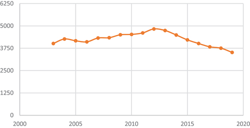
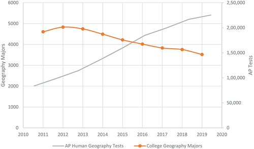
Figure 2. The number of college geography majors vs. The number of AP Human geography tests. Data source: see and https://www.Totalregistration.net/AP-Exam-registration-Service/Compare-score-Distributions.Php?id=32&year=2013, accessed 15 March 2022.
Yet student interest in a variety of topics central to geography, such as climate change, human environment interaction, economic and social inequality, and healthcare inequities remains very high. So it is surprising that geography is not a more popular field of study and it suggests there may be a mismatch between curriculum, pedagogy and student interest/expectations. A simple thought experiment might help illustrate the point: if a high school student is very interested in studying human environment interaction, where would she be able to do that, and in what fashion would she be able to engage with the relevant content? What if that student wanted to learn about GIS or other geospatial technologies?
The key gateways to geography are largely closed to high school students and participation in the only class with real leverage, Advanced Placement Human Geography, seems to be negatively correlated with the number of students pursuing geography majors over the last decade (see ).
As an alternative to AP and IB classes, collaborations between high schools and colleges can provide students with the possibility of earning college credit while still in high school. Dual enrollment – where high school students take college level courses and receive college credit – is one type of collaboration offered widely to public high school students in the United States (Cowan & Goldhaber, Citation2015). Dual enrollment courses are often, though not always, taught by college faculty at the college campus, frequently at community colleges (Witkowsky & Clayton, Citation2020). Benefits of dual enrollment include supporting students’ college readiness, increasing graduation rates, providing accelerated learning opportunities, and providing access to courses not typically offered as part of the high school curriculum (An, Citation2013; Hoffman et al., Citation2009; Lukes, Citation2014). Additionally, in some cases collaborations between high schools and universities are established to create a pathway into majors such as education (Curci et al., Citation2022), technology (Hughes et al., Citation2005), and sciences (D’Anna et al., Citation2019; Lukes, Citation2014).
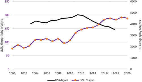
At James Madison University, we have chosen to take a different approach to working with K-12 schools, and in so doing, James Madison University has grown its geography program into one of the largest in the country. As shown in , our enrollments counter the national trend and have strongly increased. The program was recently recognized with the 2021 AAG Bachelors Program Excellence award.
Figure 3. JMU geography majors vs. US geography majors. Data sources – see and JMU office of institutional research (https://www.jmu.edu/oir/enrollment.shtml).
This growth has come about from a variety of reasons, but a key driver has been the Geospatial Semester program. In the rest of this paper, we introduce the Geospatial Semester, share details about its implementation, and discuss the research we have done regarding its impact on students’ spatial thinking and problem solving skills. We conclude by discussing how other programs can develop similar initiatives and share some of the success and challenges we have experienced.
The Geospatial Semester
The Geospatial Semester (GSS) was launched in 2005, not as a way to drive up geography enrollment, but as an intervention to bring geospatial technology to K-12 schools and to push high school students in the senior year to continue working to the end of the school year. This stemmed from the experience of one of the authors (BK) in regularly teaching first year college students in their first semester and struggling to get them reengaged with academic work. The GSS was born at a time of high-stakes testing and a diminution of inquiry-based instruction in the classroom, and as a reaction to a push from then Virginia Governor Mark Warner’s push for more AP and IB classes in the curriculum (Samuels, Citation2003).
The concept behind the GSS is simple – infuse a high school class with geospatial technology and project-based learning, and give students and teachers agency about the choice of projects and applications. We offer the class for concurrent enrollment at JMU at a large discount. Concurrent enrollment means that students are taking the class in their home high schools with the high school teachers providing the instruction (National Association of Concurrent Enrollment Partnerships, Citation2022). In our case, JMU faculty regularly visit the classes to provide mentoring, project and technology support, and quality control, so we have dubbed this “mentored dual enrollment”.
At a time when widespread adoption of geospatial technologies in schools has been quite modest, the GSS has plowed new ground in terms of how these technologies can be effectively implemented in a K-12 setting. The growing ease of use of the various online GIS tools, including ArcGIS Online, suggests that future implementation may have a shallower learning curve and lower technology support costs.
A key feature of the GSS class is an extended project driven by the students’ interest. It has been fascinating to see the range of issues that have arisen in these projects, including environmental issues such as solar or wind siting, political geography issues such as redistricting and gerrymandering, public health issues related to the pandemic, changing land use in a fast-growing county, social justice issues including food and health deserts, and even agricultural issues such as milksheds. The students are drawn to important contemporary topics in geography, spurred by the opportunity to use GIS and other technologies to analyze the wealth of data that are available.
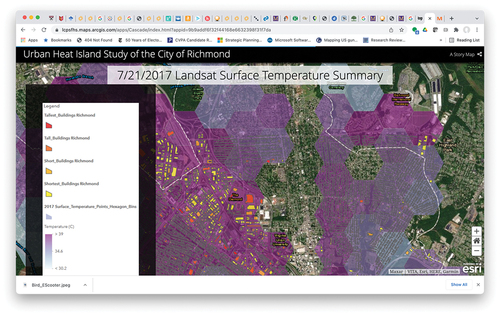
show example student projects. Additional projects can be found on the GSS website (https://isat.jmu.edu/geospatialsemester/recognition.html). The GSS culminates with students presenting their projects to JMU faculty and other external stakeholders, helping to motivate them to work through their final year of high and preparing them to defend their work in front of college faculty.
Figure 4. Example student project. This project focused on the deployment of Bird electric scooters in a city in Northern Virginia, factoring in demographics and commuting patterns.
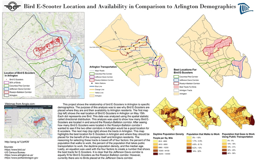
Figure 5. Example student project. This is a screenshot from a StoryMap focusing on urban heat islands in the city of Richmond, Virginia. https://lcpsfhs.maps.arcgis.com/apps/Cascade/index.html?appid=9b9addf6f32f44168e6632398f31f7da, accessed on 15 March 2022.
Geospatial Semester logistics
A key aspect of building the GSS has been developing relationships with school districts and teachers. Building on existing relationships from prior outreach work, we invited districts to participate in the project and to identify teachers who might lead the concurrent enrollment classes. The districts need to add an appropriate class to their course of study. Often, it has been a science class, but some districts offered the class for social studies or career and technical education (CTE) credit instead. At JMU, we added a course to our catalog entitled GEOG 161 – Geospatial Tools and Techniques.
To date in its 18 years of existence, the GSS has served more than 6,300 students who have earned more than 27,000 credit hours. We have had very good luck assisting those students not attending JMU in transferring the credit, although it is interesting how few four-year colleges and universities have GIS coursework in their lower division. From a financial standpoint, the GSS has been self-sufficient since 2007–2008 and currently supports 1.5 FTE. It has generated more than $2,000,000 in tuition revenue since its inception, even though we charge a steeply discounted tuition for the class. Excess revenues are shared with the geography program.
As districts came on board, we provided professional development for those teachers and lessons and other materials they could use to create their version of the GSS. Part of the appeal of the GSS to teachers is that we do not have a rigid curriculum, rather teachers and students can choose their own set of problems to which they apply geospatial technologies. We chose to use the ESRI suite of tools, in part because they are made available at no cost to K-12 schools. We have observed that prior GIS expertise is not a critical factor for success in the GSS. Rather a willingness to embrace project-based learning and to work with students as co-learners epitomizes our most successful teachers. We posit that this might be due to the fact that the software is complicated and it is difficult to master all aspects of it, even for an expert. By the teacher showing vulnerability in not knowing everything, it encourages students to explore and develop mastery they can share with the class. This is a powerful (and unanticipated) by-product of this experience.
Once teachers are on-board, building student interest in the Geospatial Semester has been critical to expanding its reach within schools. Observations and informal interviews with students in schools where the Geospatial Semester class has been well-established have indicated that factors such as the teacher, the project-based elements of the course, and word of mouth are important to students as they decide which courses to enrol for the following year. Anecdotally, many students express enthusiasm for taking a course that evaluated their performance on measures other than high stakes tests. In a prior analysis with students who did and did not enrol in the Geospatial Semester, we found that prior experience with GIS technologies was the biggest predictor of student enrollment in GSS (Peterson et al., Citation2020). First hand GIS experiences often came from having the GSS or AP Human Geography teacher incorporate a lesson on GIS in a previous course, or through out of school experiences such as Scouts or 4-H. First hand experiences using GIS technologies, not simply being aware of GIS technologies, predicted student enrolment in GSS. Notably, there was significant variability among the schools included in this analysis in terms of the proportion of students who had experience with GIS technology prior to taking the Geospatial Semester course.
Over time, more and more high school juniors were interested in taking the class and a number of them wanted additional experience in their senior year. This led us to add a second year to the program where students were able to pursue more advanced projects and develop deeper expertise with the software. These students also often help tutor and support students in their first year of the Geospatial Semester.
There have been a variety of impacts from GSS. We discuss how the experience shapes students’ spatial thinking and problem-solving below. We have also documented how the students’ final projects demonstrate 21st Century Thinking Skills (Charles & Kolvoord, Citation2016). In addition, each year, some students will take internships or volunteer with organizations that need their geospatial skills, such as local county GIS offices, businesses or non-governmental organizations (NGO’s). In a number of instances, these internships or other opportunities have shaped students’ career paths and opened a window into the study of geography. We have also received very positive feedback from the participating teachers. A number of partner teachers have shared that they have remained in the teaching profession well past their anticipated retirement date because the GSS gave them some respite from the high-stakes testing regime that has come to dominate K-12 education. They also rediscovered their passion for project-based or active learning pedagogies and have been able to ground their teaching in topics where students have interest and passion.
In addition, GSS teachers have been able to build partnerships with local government, business and industry that provide project possibilities for the students. These partnerships have allowed the students to do work that matters to the client and to start to see themselves as professionals. Both students and stakeholders report positive interactions. Although not all schools have been able to connect with external stakeholders, those that have make it a regular feature of the GSS.
Impact of the GSS on JMU geography enrollment
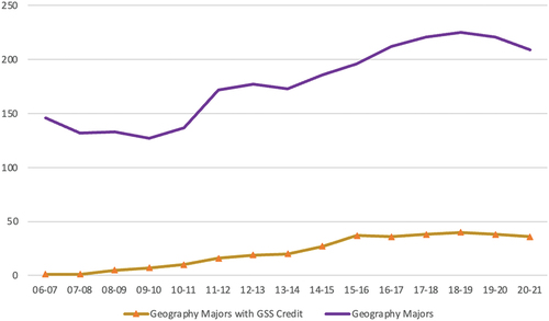
Since its inception, the GSS has introduced geography as a potential discipline for collegiate study and we have seen these students come to JMU and major in geography. shows the increase over time of students majoring in geography with credit from the Geospatial Semester. This coincides with the substantial growth of the program. Over the last six years, the percentage of students with GSS credit has varied between 17 and 19% of the total number of majors. We should note that we cannot claim causation (many factors impact a student’s choice of major), however there is a clear correlation over the history of the GSS.
Figure 6. This chart shows the total number of geography majors and those that have Geospatial Semester credit on their transcript. Data source - JMU Institutional Research.
Research on the benefits of GSS
Along with the impact of the GSS on undergraduate enrollment, we have found positive cognitive and brain-based changes for students enrolled in the Geospatial Semester (Cortes et al., Citation2022; Jant et al., Citation2020; Peterson et al., Citation2016). Specifically, we have found that students participating in the GSS leave high school ready to enter undergraduate geography courses with an increased ability to think about problems from through a spatial lens, a greater sense of themselves special thinkers, and improvements across a variety of spatial reasoning tasks.
A study by Jant and colleagues (Jant et al., Citation2020) found that students in the GSS course improved their ability to approach problems in spatial ways, with a greater degree of evidence-based reasoning. In this study, GSS students, but not a comparison group of students enrolled in AP science courses, used more spatial language from the beginning to the end of the school year when solving real world reasoning problems. Additionally, at the end of the course, students’ ability to provide claims backed up with evidence and reasoning was greater for students who had taken the Geospatial Semester relative to the comparison group.
The ability for students to think about problems in a spatial way has been observed across a variety of measures in a follow up study (Cortes et al., Citation2022; Peterson et al., Citation2016). In this study, we examined students’ spatial habits of mind; that is, the extent to which they think about themselves as spatial thinkers and engage in spatial practices in their everyday lives, such as using spatial language and concepts (Kim & Bednarz, Citation2013). Students who had completed the Geospatial Semester had a greater improvement in their spatial habits of mind relative to students in other science elective courses (Cortes et al., under review). Notably, while students enrolled in the Geospatial Semester showed an increase in their spatial habits of mind, students in other courses showed decreases in spatial habits of mind from the beginning to the end of the year. Moreover, benefits of the Geospatial Semester were greater for female students (Peterson et al., Citation2016). These findings align with prior research showing that taking an undergraduate GIS course supports students’ spatial habits of mind (Kim & Bednarz, Citation2013).
In addition to assessing students’ tendency to approach problems in spatial ways, more recent analysis has examined whether the Geospatial Semester may support students’ spatial skills as assessed through cognitive measures (Cortes et al., in press). Students enrolled in the Geospatial Semester showed greater improvement relative to their peers on some, but not all, spatial tasks. Compared to peers enrolled in other science elective courses, students in the Geospatial Semester had greater improvements in a visual search task from the beginning to the end of the school year, but not in a mental rotation task (Cortes et al., in press).
Additionally, there is evidence that gains in spatial thinking from the Geospatial Semester transfer to verbal reasoning tasks where comparisons among premises can be visualized (Cortes et al., Citation2022). Students who took the GSS improved both when comparing relations that are explicitly spatial, such as above and below, as well as relations that are not explicitly spatial, but can be visualized specially, such as better and worse. For a subset of students who completed the verbal reasoning tasks while having patterns of brain activity monitored through functional magnetic resonance imaging (fMRI), we found that students who completed the Geospatial Semester changed how they processed these problems from the beginning to end of year. Specifically, the pattern of brain activation suggested that students who took the GSS were more likely to show greater activation of regions associated with spatial processing while solving these verbal problems. Further, students who took GSS showed greater co-activation of between regions of the brain implicated in spatial reasoning and a frontal region of the brain associated with abstract reasoning and higher-order thinking (Cortes et al., Citation2022).
Discussion and conclusions
Establishing and sustaining the GSS has not been without challenges. Even with the salutary effects on teachers, longevity in the classroom is growing shorter and shorter, and we regularly need to work with schools to onboard new teachers. We are fortunate to have an established base of teachers that are willing mentors and partners, but the regular replacement of participating teachers is difficult.
Deciding on the rate of growth has also been challenging. We have shared details of the GSS regularly at teacher conferences and with school districts, but we have largely waited for school districts to come to us when they’re ready. This was done in part because we wanted to make sure we had the staffing to support the mentored dual enrollment and not get overwhelmed by growing too quickly. Another challenge, pre-pandemic, was the strain of driving to all the schools, which are not concentrated within a single region in Virginia, to make regular visits. We did transition to online visits during the pandemic. They were useful for some interactions, but not so much for others. We will continue to experiment with more online visits going forward.
We also struggled during the pandemic with keeping student motivation high and having students produce high quality work. While we were not alone in this struggle, we did notice a downturn in student work over the past two years, in part driven by some of the limitations placed on teachers by their schools about what could be required of their students.
All challenges aside, the GSS has contributed to an increase in the number of geography majors at JMU, and it has propelled a generation of students to a deeper understanding of geospatial technologies and the kinds of problem that are amenable to spatial analysis. Students have seen significant growth in their spatial thinking and problem-solving skills, especially when compared to similarly able peers. University programs wanting to both connect with local and regional K-12 schools and to grow their enrollment should consider efforts akin to the Geospatial Semester.
The structure of the GSS also connects well with the Powerful Geography movement referenced above. By giving the students agency, it offers both the teachers and the students to connect with culturally relevant topics that can open the door to geography to underrepresented and minoritized students in new ways. Using geospatial technology as the onramp to spatial thinking and problem solving is an approach that can, as we’ve shown, bear considerable promise.
In summary, the GSS offers a number of benefits to students, teachers, project stakeholders, and universities. Students are able to build both technology and spatial thinking and problem-solving skills, opening up new possibilities both in STEM careers and more broadly. Teachers find the process of teaching the GSS professionally rejuvenating and appreciate the opportunity to bring project-based learning back to the center of the classroom. External stakeholders get useful project work done and are able to connect with the next generation of talent. The university is able to support K-12 teachers and establish a pipeline into an often overlooked major. We encourage other programs to explore instituting a similar program and we will be happy to help you get started.
Disclosure statement
No potential conflict of interest was reported by the author(s).
Additional information
Funding
References
- Allen, K. M. (2015). (In)visible sons: Exploring the enactment of culturally relevant pedagogy with African American adolescent males [ Doctoral dissertation]. Retrieved from ProQuest Dissertations & Theses Global. ( 1695272248).
- An, B. P. (2013). The impact of dual enrollment on college degree attainment: Do low-SES students benefit? Educational Evaluation and Policy Analysis, 35(1), 57–75. https://doi.org/10.3102/0162373712461933
- Boehm, R. G., Solem, M., & Zadrozny, J. (2018). The Rise of Powerful Geography. The Social Studies, 109(2), 125–135. https://doi.org/10.1080/00377996.2018.1460570
- Charles, M. T., & Kolvoord, R. A. (2016). Geospatial semester: Developing students’ 21st century thinking skills with GIS: A three year study. Pyrex Journal of Educational Research and Reviews, 2(6), 67–78.
- Cortes, R. C., Peterson, E. G., Kraemer, D. J. M., Kolvoord, R. A., Uttal, D. H., Dinh, N., Weinberger, A. B., Daker, R. J., Lyons, I. M., Goldman, D., & Green, A. E. (2022). Transfer from spatial education to verbal reasoning and prediction of transfer from learning-related neural change. Science Advances, 8(32). https://doi.org/10.1126/sciadv.abo355
- Cowan, J., & Goldhaber, D. (2015). How much of a“running start” do dual enrollment programs provide students? The Review of Higher Education, 38(3), 425–460. https://doi.org/10.1353/rhe.2015.0018
- Curci, J. D., Johnson, J. M., Gabbadon, A. T., & Wetzel-Ulrich, E. (2022). Expanding the pipeline to teach: Recruiting future urban teachers of color through a dual enrollment program. The Urban Review, 55(2), 1–20. https://doi.org/10.1007/s11256-022-00646-1
- D’Anna, S., Denmark, B., Rosenthal, M., & Maillet, J. O. S. (2019). High school students’ college outcomes in a dual enrollment program, 1998-2015. Journal of Allied Health, 48(4), 263–269.
- Hoffman, N., Vargas, J., & Santos, J. (2009). New directions for dual enrollment: Creating stronger pathways from high school through college. New Directions for Community Colleges, 2009(145), 43–58. https://doi.org/10.1002/cc.354
- Hughes, K. L., Karp, M. M., Bunting, D., & Friedel, J. (2005). Dual enrollment/dual credit: Its role in career pathways. Career Pathways: Education with a Purpose, 227–255.
- Jant, E. A., Uttal, D. H., Msall, K., James, C., & Msall, C. (2020). Defining and measuring the influences of GIS-based instruction on students’ STEM-relevant reasoning. The Journal of Geography, 119(1), 22–31. https://doi.org/10.1080/00221341.2019.1676819
- Jones, M. C., & Luna, M. (2018). Geography deserts: State and regional variation in the formal opportunity to learn geography in the United States. Journal of Geography, 118(2), 1–13. https://doi.org/10.1080/00221341.2018.1521463
- Kaplan, D. (2019). President’s Column, AAG Newsletter. Retrieved June 21, 2022, https://www.aag.org/should-we-be-worried-or-how-to-maintain-and-expand-the-number-of-geographers-in-our-schools/
- Kim, M., & Bednarz, R. (2013). Effects of a GIS course on self-assessment of spatial habits of mind (SHOM). Journal of Geography, 112(4), 165–177. https://doi.org/10.1080/00221341.2012.684356
- Lukes, L. A. (2014). Two-year Community: Considerations and recommendations for implementing a dual-enrollment program: Bridging the gap between high school and college level science. Journal of College Science Teaching, 44(1), 17–22. https://doi.org/10.2505/4/jcst14_044_01_17
- National Association of Concurrent Enrollment Partnerships. (2022). What is concurrent enrollment. Retrieved June 21, 2022, https://www.nacep.org/about-nacep/what-is-concurrent-enrollment/
- Peterson, E. G., Kolvoord, R. A., Uttal, D. H., Goldman, D., Hollenbeck, E., Kraemer, D. J. M., & Green, A. (2016, September). Spatial thinking in the high school classroom: Cognitive and neural effects of the Geospatial semester. Paper presented at the conference of the International Mind, Brain and Education Society, Toronto, Canada.
- Peterson, E. G., Kolvoord, R. A., Uttal, D. H., & Green, A. E. (2020). High school students’ experiences with geographic information systems and factors predicting enrollment in the Geospatial semester. Journal of Geography, 119(6), 238–247. https://doi.org/10.1080/00221341.2020.1824009
- Samuels, C. A. (2003). Warner promotes education initiative. Washington Post. Retrieved December 2, 2022, https://www.washingtonpost.com/archive/local/2003/10/05/warner-promotes-education-initiative/6dbacf36-4cbf-440b-b1c5-7973f158a912/
- Solem, M., Vaughan, P., Savage, C., & De Nadai, A. S. (2021). Student- and school-level predictors of geography achievement in the United States, 1994–2018. Journal of Geography, 120(6), 201–211. https://doi.org/10.1080/00221341.2021.2000009
- Witkowsky, P., & Clayton, G. (2020). What makes dual enrollment work? High school counselor perspectives. Community College Journal of Research and Practice, 44(6), 427–444. https://doi.org/10.1080/10668926.2019.1610676