
ABSTRACT
Current environmental crises call for an integrated knowledge of landscapes and their ecosystems in a broader sense. This article presents a pedagogical framework for cross-disciplinary landscape research at postgraduate level. The framework is grounded in the use of geospatial epistemic discomfort as a creative force to develop and enhance inquiry skills able to cross and merge disciplinary boundaries. Developed within the Erasmus+ KA2 project “CROSSLAND”, the pedagogical framework is based on the scaffolding of epistemic discomfort through four key didactic elements: 1) cross-disciplinary group work and open-ended assignment, 2) in-field inquiry as pre-training on space-time, 3) replacement of traditional lectures by student-led seminars, 4) GIS labs centred on the exploration of cross-disciplinary portfolios of geospatial approaches and methods given as worked-out examples. Main results from the evaluation of the framework implementation in a Summer School show how learning cross-disciplinarity happened thanks to a scaffolding that allowed, first and foremost, the socialisation of different conceptualisations of space. While students felt at ease with geospatial epistemic discomfort, we can conclude that spatial cognitive processes are powerful in improving abilities beyond the spatial domain.
Introduction
Geospatial thinking allows crossing and transcending disciplinary boundaries since the conceptual understanding of the spatial dimension is common to most disciplines (Hawkey et al., Citation2019). Through spatial thinking, disciplines can be accessed and merged to acquire new knowledge. If we use geospatial cognition as a pedagogical tool, students can develop the ability to move between a variety of disciplinary modes and languages, learning to recognise that diverse epistemologies of the spatial co-exist (Bearman et al., Citation2016; Goodchild & Janelle, Citation2010), thus making sense of the complexity of our reality and the multiple ways to investigate it (Elwood & Wilson, Citation2017; Mathews & Wikle, Citation2019).
In this paper, we present a pedagogical framework for cross-disciplinary landscape research, grounded on scaffolding geospatial epistemic discomfort as a creative force in student-centred active learning. The framework was developed within the project “CROSSLAND. A new cross-disciplinary framework for studying the landscape over the long term” (hereafter CROSSLAND) and tested during a Summer School for postgraduate and PhD students in 2022. The experience of the participants (both students and tutors) is presented here, together with reflections on lessons learnt, setting the stage for the work ahead.
Designing discomfort in the third space: the CROSSLAND summer school
Student-active learning (Barrineau et al., Citation2019; Bolander, Citation2001; Castellanos-Reyes, Citation2020; O’Neill & McMahon, Citation2005) helps develop students´ understanding of the real world through direct exploration, engagement, interactions and negotiations with peers.
Among the many active-learning approaches, the inquiry-based method enables students to develop conceptual understanding and reasoning skills by exploring the complexity of real-world connections, in an independent and open-ended process in which the students themselves lead the inquiry in terms of research question, hypothesis and methodology to adopt (Houser et al., Citation2017; Landenberger et al., Citation2006; Song & Schwenz, Citation2013). For its own critical and self-driven explorative nature, inquiry-based learning is considered particularly suitable for the development of geographic education (Passon & Schlesinger, Citation2019). Inquiry-based learning may thus lead to the development of critical thinking, high-level questioning and the discovery of new knowledge (Lazonder & Harmsen, Citation2016; Pedaste et al., Citation2015) on the interconnections between the physical and socio-cultural environment in their spatial dimensions. Conversely, such intellectual freedom may create a feeling of discomfort, rising from the frustration and anxiety felt by the students over the lack of structure and instructions that geography courses based on student-active and inquiry-based pedagogy usually have (Spronken-Smith et al., Citation2008). However, such discomfort may be a transformative and productive force (Houwer, Citation2011). Pedagogies of discomfort intentionally challenge students´ perceptions, knowledges and “ontological security” (Clayton et al., Citation2023, p. 4), embedding the tensions derived from crossing epistemic borders within an inclusive learning environment that supports such tensions as creative. Navigating discomfort, in other words balancing the students´ freedom to explore with the amount of guidance to provide, is however a delicate task. CROSSLAND focused on how we could scaffold geospatial epistemic discomfort so to allow it to become a creative force in enhancing cross-disciplinary research skills. By scaffolding, we mean the design of course content and material in a way that they fall within a learner’s Zone of Proximal Development (ZPD, Vygotsky, Citation1978). The ZPD refers to learning objectives out of reach of an independent novice learner, but that can be successfully reached with instructional support.
The intended learning objectives of our “pedagogy of discomfort” were:
Develop a personal identity as a cross-disciplinary researcher, gaining the ability to formulate research questions bridging disciplinary divides;
Gain a deeper understanding of spatial conceptualisations;
Develop cognitive skills to move easily from conceptualisation to operationalisation.
We thus designed a Didactic Unit in the form of an intensive 7-day Summer School for postgraduate and PhD students, by purposefully scaffolding four “significant didactic facts” (Godino et al., Citation2019, p. 151):
Cross-disciplinary group work and open-ended assignments. Students are divided into cross-disciplinary groups and given an open-ended assignment on a given study area: Use geospatial analysis to conduct research on a topic of your own choice for the study area X.
In-field inquiry as pre-training on space-time. The School begins with a one-day hiking trip to explore the assigned study area. Tutors and local experts act as facilitators, accompanying students through the exploration of landscape different temporal and socio-cultural elements, letting them develop spatial questions that would then be addressed as group assignment.
Student-led seminars replace traditional lectures. Every morning students discuss papers provided in advance by the tutors (selected and scaffolded to be the theoretical support to each afternoon GIS Lab) and selected by the students themselves on the last day of the seminar activities. Each seminar includes both fish-bowl conversations and plenary discussions.
Cross-disciplinary “portfolios” of geospatial approaches and methods. During each afternoon GIS lab, students are given a new portfolio of geospatial approaches and techniques, in the form of a short presentation by the tutors and a collection of worked-out examples (Howarth, Citation2015) with open-source GIS software, which they can use as supportive material to develop their group project work. These “portfolios” are cross-disciplinary and show the students how different disciplines utilise geospatial analysis to investigate the spatial dimension of landscape, its spatiotemporal dimension and its contextual dimension (as different methods to investigate space co-exist, thus different conceptualisations and interpretations of space co-exist).
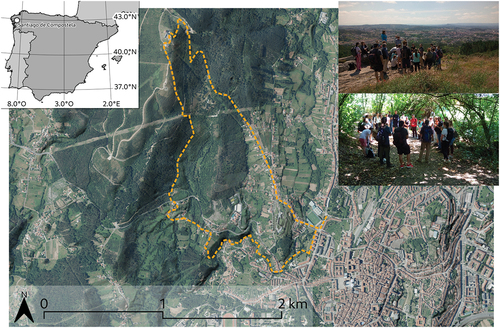
The Didactic Unit was tested in the Summer School “Cross-disciplinary spatial approaches to study long term landscape dynamics”, which took place in Santiago the Compostela on July 4th- 10th, 2022. The Summer School, a 3-credit module, consisted of 6 hours of fieldwork, 6 hours of seminars and 25 hours of project work/GIS labs (Annex 1). The assigned study area was the city of Santiago the Compostela and its peri-urban surroundings (). A basic dataset on the case study area was given to the students as well.
Figure 1. Field excursion on Monte Pedroso to explore the assigned case study area. Cartographic data derived from PNOA 2020 and MDS05, CC-BY, Spanish National Cartographic System, scne.Es.
The format of the Summer School was chosen as the embodiment of the third space, a liminal and in-between space outside disciplinary departments´ frames and their fixed curricula, allowing the transgression of disciplinary boundaries and our re-positionality as producers of cross-disciplinary knowledge (Tremonte, Citation2011). Furthermore, its short duration allows students and tutors from different locations worldwide to gather in Santiago for one week. The School attracted 23 students, selected by the partner universities through an open call. Requirements were basic literacy in GIS and a broad interest in landscape research. The participants had different backgrounds, nationalities, and mixed levels in their academic path (12 Master’s students and 11 PhD candidates). Moreover, the Summer School had a tutoring staff consisting of two experts in GIS and remote sensing in forestry, landscape ecology, and ecology; two experts in landscape archaeology and spatial digital humanities; two experts in geodesy, photogrammetry, and machine learning; two experts in GIScience and pedagogy; two experts in historical geography and remote sensing.
Methodology
The Summer School was evaluated using the phenomenography approach (Marton, Citation1981, Citation1986; Marton & Booth, Citation1997; Marton et al., Citation1997; McGrath et al., Citation2021; Mimirinis & Ahlberg, Citation2020; Öhrstedt & Scheja, Citation2018).
As an epistemological approach, phenomenography assumes that important learning in higher education happens during the cognitive transition process from preconceptions of phenomena to their improved understanding (Marton et al., Citation1997). Each person experiences phenomena in qualitatively different ways, having different understandings of these phenomena and assigning to them diverse meanings. By examining students´ qualitative perceptions of the learning experience is thus possible to reach insights into learning as a cognitive process, both at the individual and group level. In phenomenography, the research focus is centred at the group level, but it is reached through a first analysis of the meanings that individual students attribute to their learning experience. These individual meanings are grouped into categories, by marking meaningful utterances in interview transcripts that reveal students´ qualitative perceptions of the learning process. Bringing together these individual quotes at the group level will develop further the meaning of the categories and determine “the pool of meanings” (Marton et al., Citation1997, p. 42) used to analyse the learning process happening within the group as a whole. At this level the phenomenographic analysis is thus iterative, being focused on the “pool of meanings” that help better understand the qualitative dynamics of learning, while taking into account now both the individual and the group contexts where the attribution of the meaning of the learning experience took place.
In CROSSLAND, data were collected in two different rounds: a focus group discussion immediately after the Summer School and a semi-structured questionnaire sent via email to all participants seven months after the end of the School. Both collection rounds featured questions about students´ perceptions of learning outcomes and which elements of the School most contributed to these, as well as recommendations for improvements. The questionnaires (Annex 2) were designed to trace the learning steps by drawing out meanings behind students´ affirmations. The authors carried out the analysis of responses first individually, and then met to compare groupings of meanings and summaries of the main themes emerging, translated into categories that describe students´ perceptions.
Once the analysis of the students´ responses was concluded, the project working group reflected as well on their perceived experience of the Summer School.
Students´ perceptions of…
… the learning outcomes
Results from the phenomenography analysis of the Summer School (SS) show that the participants overall were satisfied with the course, feeling to have been intellectually stimulated and challenged. The most important learning outcome perceived by the participants was the awareness that geospatial analysis can open up to cross-disciplinary thinking. The students felt that this awareness opens up new, multiple, and more complex conceptualisations of space. Among all the different components of the SS, the participants perceived that the project work in their cross-disciplinary groups contributed the most to their learning, and felt very frustrating at the beginning, but highly rewarding at the end. The most controversial feature of the Summer School structure was the student-led morning seminars, some students liked it, others not. The categories of description resulting from the phenomenography analysis are elaborated in detail below, with some excerpts from respondents to illustrate key aspects of their conceptions.
Participants stated that they learned how to communicate with colleagues from other disciplines and different academic backgrounds. The result was a better understanding of different perspectives and research approaches, while at the same time reaching, as one student wrote, “a broader way of thinking about geospatial and landscape analysis”. The capability of geospatial analysis as a research approach to cross-disciplinarity collaboration was new and unexpected for the participants. At the same time, it facilitated creative work and allowed for the development of new ideas. In parallel, once reached a “cross-disciplinary mindset”, participants perceived they learnt to read spatial analysis research critically.
The second most important learning outcome perceived by the participants was the understanding that multiple conceptualisations of space can co-exist at once, as commented by several students: “Experiencing and knowing that my colleagues conceptualise space and spatial analysis in a different manner than I do was eye-opening”, “The biggest takeaway was a change in perspective (…)to address spatial analysis taking in consideration multiple variables and aspects”. Together with this ability to conceptualise the multiplexity of space and the acquisition of new ways to investigate such multiple complex reality, came the ability to combine different methods and data to address specific research questions: “Before the summer school it was a bit challenging to conceptualise the relationship between different landscape components, now this is something that can be done”.
… the course structure
The element of the Summer School perceived by the participants to have contributed the most to their learning outcomes was the group work done during the afternoon GIS labs. While working on their common group research project, the students perceived to have learnt different perspectives on approaches to geospatial analysis and specific techniques by directly integrating them into practice: “I see the potentiality of bringing together people with and from different backgrounds in GIS and landscape analysis”. Participants learned how to manage a project with colleagues from different backgrounds, knowledge and research expectations: “It was an interesting challenge to find a common objective and method approach that utilises everyone’s expertise in a good way”, and specific techniques by directly integrating them into practice. “Precious” was both the freedom and independence given to the students in leading their learning process through the group project work, and the presence of “super available” tutors to discuss approaches and methodologies, or to solve more direct technical issues. The GIS labs were “a more general and mind-broadening learning experience”, “very frustrating at the beginning but at the end, when we finally got some results, was quite rewarding”, where participants learned above all that the choice of methods or approaches depends entirely on the research questions.
Opinions on the effectiveness of the student-led seminars varied. Some of the participants did not find the morning seminars helpful in reaching new learning outcomes. Some students perceived the seminars as too theoretical “meta-discussions concerning cross-disciplinary aspects of spatial analysis”. Participants were interested in practical work and the finalisation of their group project work: “Less seminars, more labs and more time to work on the project work”. However, the students who found the morning seminars useful to the learning outcomes thought they were “very educational […] it helped me approach spatial analysis from different points of view and provide theoretical frameworks”. It was particularly during the student-led seminars that participants experienced and thus understood that “my colleagues conceptualise space and spatial analysis in different ways”, “a realisation which was important for the group project”.
Student-led seminars were also perceived as difficult due to group dynamics “Colleagues were pushing the discussion to their own field” but, similarly, they “forced people to take a look at something that they probably would never know by themselves”. The effectiveness of the seminars relied on the student active-learning approach, as one student commented: “If the morning seminars had not been student-led, I would not have read [the papers] as carefully”. Accordingly, the seminar the participants liked the most was the one in which they had to choose the papers to discuss.
The last “significant didactic fact” of the Summer School was the field activity. According to most students, the one-day hiking trip through the study area contributed only minimally to their learning: “Generally speaking, I have learned more in the classroom”. However, students perceived they specifically learnt during the field activity how spatial patterns change over time, and that the “once obvious” divide between cultural and natural landscape “during the day got more fuzzy and ended with me thinking that everything was just cultural landscape”. Thanks to the field excursion, participants felt they began reflecting on space as a multiple and complex reality, finding the excursion useful in this regard: “I learned that people from different disciplines experience and see the landscape differently”.
Concluding discussion
In CROSSLAND, three elements of inquiry intersect: cross-disciplinary epistemologies, spatiotemporal methods of analysis and visualisation, and a thematic focus on human-environmental change expressed through the landscape ().
Figure 2. Intellectual interconnection and interdependence when doing applied cross-disciplinary research adopting geospatial inquiry methods.
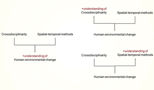
The various intersections of these elements identify questions of broad intellectual merit that transcend the place and time of a single field school. How do cross-disciplinary applications of spatial-temporal methods enrich our understanding of the human-environmental change? What are the similarities and differences in the ways different disciplines conceptualise space and change? What are the limits to current spatial-temporal methods for supporting cross-disciplinary studies of landscape change? And perhaps most immediately, how can educators help students navigate the intrinsic difficulty and epistemic discomfort induced when exploring these kinds of questions?
Through the work done in CROSSLAND, we framed a pedagogical approach grounded in scaffolding geospatial epistemic discomfort as a creative force to develop abilities in cross-disciplinary research. One student summarised the course saying: “I have learned more in a week than in a whole semester”. This general learning objective was achieved when students worked in a cross-disciplinary group of peers, where they first had to agree on a common (spatial) research interest and then negotiate with their colleagues the geospatial methods and data to use to pursue their commonly agreed research project. This process was supported by a set of parallel activities (geospatial inquiry in the field and critical thinking around papers). The phenomenography assessment of students´ learning steps suggests that they achieved a cognitive understanding of space as a multiple and complex reality, that can be approached and investigated through combined perspectives and methods. These results let us conclude that the initial foreseen learning outcomes of our pedagogical framework (cf. p.4) have been reached through the way in which we designed the Summer School. Its combination of theoretical discussions (student-led seminars) and practical labs for the group exploration of geospatial approaches and techniques portfolios worked very well, as the students developed a range of hypotheses centred on the use of space as a concept and geospatial analysis as functional toolsets to address their research questions. Most importantly, learning in cross-disciplinarity happened thanks to a scaffolding that allowed, first and foremost, the socialisation of different conceptualisations of space. The way students´ groups initially conceptualised the spatial problem of choice affected the way they designed the solution, but this entire cognitive process had been moulded through a conceptualisation of space happening within a cross-disciplinary dimension. Such observation leads us to notice how improvements in spatial cognitive processes can improve abilities beyond the spatial domain (Cortes et al., Citation2022). The case represented by CROSSLAND may thus lead to the educational hypothesis that curricula designed to foster spatial cognition might yield transfer to cognitive abilities that go beyond the spatial domain. Furthermore, CROSSLAND, with a focus on the spatial dimension as starting point to expand into cross-disciplinarity mindset, may provide relevant contributions to understanding how far inquiry approaches alone can support learning. The results of our project provide evidence that the didactic trajectory we designed (scaffolding epistemic discomfort through moments of inquiry, cooperative and dialogic work, and moments based on knowledge transmission, as with the “portfolios” of worked-out examples) can support mixed instructional models, able to overcome the dichotomy between inquiry-based and transmission-based theories of learning.
We observed some limitations as well, which can be translated as improvements in the scaffolding of a future Summer School: 1) a better connection between the data and what is “outside” the data in a real research context, emphasising more the importance of combining fieldwork, expert knowledge and spatial analysis (e.g. through community-based research); 2) a reduction of the cognitive load in the students, with the morning slot to prefer for lab work, while afternoon sessions better dedicated for student-led discussions around papers.
The framework developed in CROSSLAND remains fully human-centred, while improvements must be done also at theoretical level, with at least the inclusion of climate, water and animal ecology as active agents in landscape processes.
Acknowledgements
We would like to express our gratitude to the anonymous reviewers for the useful comments on earlier versions of the manuscript, as well as to the staff of the UL1 and UL2 courses organised by the Centre for the Advancement of University Teaching (CeUL Teaching) at Stockholm University for the support on pedagogical theory.
Disclosure statement
No potential conflict of interest was reported by the author(s).
Additional information
Funding
References
- Barrineau, S., Engström, A., & Schnaas, U. (2019). An active student participation companion. Avdelningen för kvalitetsutveckling - Enheten för universitetspedagogik.
- Bearman, N., Jones, N., André, I., Cachinho, H. A., & DeMers, M. (2016). The future role of GIS education in creating critical spatial thinkers. Journal of Geography in Higher Education, 40(3), 394–408. https://doi.org/10.1080/03098265.2016.1144729
- Bolander, K. (2001). Good practice in lecturing. research review paper 2. Part of Effective Lecturing Project, University of Glasgow.
- Castellanos-Reyes, D. (2020). 20 years of the community of inquiry framework. Tech Trends, 64(4), 557–560. https://doi.org/10.1007/s11528-020-00491-7
- Clayton, J., Griffin, P., & Mowl, G. (2023). Experiencing (dis)comforting pedagogies: Learning critical geography beyond the here and now. Journal of Geography in Higher Education, 43(3), 1–17. https://doi.org/10.1080/03098265.2023.2198201
- Cortes, R. A., Peterson, E. G., Kraemer, D. J. M., Kolvoord, R. A., Uttal, D. A., Dinh, N., Weinberger, A. B., Daker, R. J., Lyons, I. A., Goldman, D., & Green, A. E. (2022). Transfer from spatial education to verbal reasoning and prediction of transfer from learning-related neural change. Science Advances, 8(32), eabo3555. https://doi.org/10.1126/sciadv.abo3555
- Elwood, S., & Wilson, M. (2017). Critical GIS pedagogies beyond ‘week 10: Ethics’. International Journal of Geographical Information Science, 31(10), 2098–2116. https://doi.org/10.1080/13658816.2017.1334892
- Godino, J. D., Rivas, H., Burgos, M., & Wilhelmi, M. R. (2019). Analysis of didactical trajectories in teaching and learning mathematics: Overcoming extreme objectivist and constructivist positions. International Electronic Journal of Mathematics Education, 14(1), 147–161. https://doi.org/10.12973/iejme/3983
- Goodchild, M. F., & Janelle, D. G. (2010). Toward critical spatial thinking in the social sciences and humanities. Geo Journal, 75(1), 3–13. https://doi.org/10.1007/s10708-010-9340-3
- Hawkey, K., James, J., & Tidmarsh, C. (2019). Using wicked problems to foster interdisciplinary practice among UK trainee teachers. Journal of Education for Teaching, 45(4), 446–460. https://doi.org/10.1080/02607476.2019.1639263
- Houser, C., Bishop, M. P., & Lemmons, K. (2017). Teaching complex concepts in the geosciences by integrating analytical reasoning with GIS. Journal of Geoscience Education, 65(3), 263–271. https://doi.org/10.5408/16-152.1
- Houwer, R. (2011). Learning freedom: The pedagogical potential of crisis. Journal for Activism in Science and Technology Education, 3(1), 109–117. Retrieved October 4, 2023, from https://jps.library.utoronto.ca/index.php/jaste/article/view/21201.
- Howarth, J. (2015). Learning by solving problems: Cognitive load theory and the Re-design of an introductory GIS course. Cartographic Perspectives, (80), 18–34. https://doi.org/10.14714/CP80.1320
- Landenberger, R. E., Warner, T. A., Ensign, T. I., & Duane Nellis, M. (2006). Using remote sensing and GIS to teach inquiry‐based spatial thinking skills: An example using the GLOBE Program’s integrated earth systems science. Geocarto International, 21(3), 61–71. https://doi.org/10.1080/10106040608542394
- Lazonder, A. W., & Harmsen, R. (2016). Meta-analysis of inquiry-based learning: Effects of guidance. Review of Educational Research, 86(3), 681–718. https://doi.org/10.3102/0034654315627366
- Marton, F. (1981). Phenomenography—describing conceptions of the world around us. Instructional Science, 10(2), 177–200. https://doi.org/10.1007/BF00132516
- Marton, F. (1986). Phenomenography—a research approach to investigating different understandings of reality. Journal of Thought, 21(3), 28–49.
- Marton, F., & Booth, S. (1997). Learning and awareness. Routledge.
- Marton, F., Säljö, R., & Entwistle, N. J. (1997). Approaches to learning. In F. Marton & D. Hounsell (Eds.), The experience of learning. Implications for teaching and studying in higher education (2nd ed., pp. 39–58). Scottish Academic Press.
- Mathews, A., & Wikle, T. (2019). GIS&T pedagogies and instructional challenges in higher education: A survey of educators. Transactions in GIS, 23(5), 892–907. https://doi.org/10.1111/tgis.12534
- McGrath, C., Ståhle, Y., & Geijer, L. (2021). What’s in a grade? Teacher candidates’ experiences of grading in higher education: A phenomenographic study. Education Sciences, 11(8), 422. https://doi.org/10.3390/educsci11080422
- Mimirinis, M., & Ahlberg, K. (2020). Variation in education doctoral students’ conceptions of university teaching. British Educational Research Journal, 47(3), 557–578. https://doi.org/10.1002/berj.3669
- Öhrstedt, M., & Scheja, M. (2018). Targeting efficient studying–first-semester psychology students’ experiences. Educational Research, 60(1), 80–96. https://doi.org/10.1080/00131881.2017.1406314
- O’Neill, G., & McMahon, T. (2005). Student-centred learning: What does it mean for students and lecturers? In G. O’Neill, S. Moore, & B. McMullin (Eds.), Emerging issues in the practice of University Learning and teaching (pp. 27–36). University College Dublin.
- Passon, J., & Schlesinger, J. (2019). Inquiry-based learning in geography. In H. A. Mieg (Ed.), Inquiry-based learning – undergraduate research (pp. 281–290). Springer. https://doi.org/10.1007/978-3-030-14223-0_26
- Pedaste, M., Mäeots, M., Siiman, L. A., de Jong, T., van Riesen, S. A. N., Kamp, E. T., Manoli, C. C., Zacharia, Z. C., & Tsourlidaki, E. (2015). Phases of inquiry-based learning: Definitions and the inquiry cycle. Educational Research Review, 14, 47–61. https://doi.org/10.1016/j.edurev.2015.02.003
- Song, Y., & Schwenz, R. (2013). An inquiry-based approach to teaching the spherical earth model to preservice teachers using the global positioning system. Journal of College Science Teaching, 42(4), 50–58.
- Spronken-Smith, R., Bullard, J. O., Ray, W., Roberts, C., & Keiffer, A. (2008). Where might sand dunes be on Mars? Engaging students through inquiry-based learning in geography. Journal of Geography in Higher Education, 32(1), 71–86. https://doi.org/10.1080/03098260701731520
- Tremonte, C. M. (2011). Graduate education, SOTL and the third space. Arts and Humanities in Higher Education, 11(4), 387–405. https://doi.org/10.1177/1474022211416451
- Vygotsky, L. S. (1978). Mind in society: The development of higher psychological processes. Harvard University Press.