
 ?Mathematical formulae have been encoded as MathML and are displayed in this HTML version using MathJax in order to improve their display. Uncheck the box to turn MathJax off. This feature requires Javascript. Click on a formula to zoom.
Abstract
Recent excavations at Millukmungee 1, a limestone rock shelter along the upper bank of the Buchan River in GunaiKurnai Country (southeastern Australia), uncovered archaeological evidence of Mid- to Late Holocene occupation spanning c. 5000 years. Here we report on the stone artefacts and faunal remains, especially in light of a paucity of published details on artefact types and technologies for this part of southeast Australia. Results indicate that this part of the site was occupied only rarely from 5590–5050 cal BP (the uncertainty range for the oldest artefact from the excavation) to 2340–2030 cal BP. During this period, most of the artefacts were made from silcrete, quartz, chert, and quartzite. Small backed artefacts are present during this phase, all dating between 4570–1940 cal BP. A single, much larger backed artefact (elouera) dates to later, ≤290 cal BP. After 1960 cal BP, activities focussed on the production of flakes from locally available quartz and, to a lesser extent, hornfels; large pebbles obtained from the nearby Buchan River channel were flaked during this period. Occupation ceased with the onset of settler colonialism in the mid-1800s CE.
Introduction
This paper reviews what has previously been published on the stone artefacts of GunaiKurnai Country and adjacent areas in southeastern Australia, and presents new results from a recently excavated site. It aims to redress a paucity of available details about the types and technologies of stone artefacts in GunaiKurnai Country, through the analysis of the artefacts recovered from the Millukmungee 1 rock shelter. We reflect on these findings for what they say about the occupation of this area of GunaiKurnai Country over the past c. 6000 years.
Background
Stone artefacts have been a major source of information about the past in Australian archaeology since the founding days of the discipline (e.g. Kenyon and Stirling Citation1901; MacPherson Citation1885). From the 1930s through to the 1950s especially, before the advent of radiocarbon (from here-on ‘14C’) dating, the pioneers of Australian archaeology formulated regional stone ‘implement’ typologies arranged into successive ‘industries’ or ‘traditions’ (assemblage sequences) that acted as proxies for overarching patterns of culture change and spatial connections (e.g. see the many examples listed in McCarthy et al. Citation1946). Of these, the best-known and most influential chronological schemas are arguably Tindale’s successive Kartan, Tartangan, Pirrian, Mudukian, and Murundian ‘cultures’ (e.g. Hale and Tindale Citation1930) and McCarthy’s three-phase Capertian, Bondaian and Eloueran ‘Eastern Regional Sequence’ (McCarthy Citation1948, Citation1964; see also Hiscock and Attenbrow Citation2005).
The 1960s through to the mid-1980s saw a change in approach as the discipline burgeoned and increasingly professionalised, and as excavated assemblages began to be 14C-dated. The regional cultural sequences that defined the earlier approaches gave way to pan-Australian traditions as the artefact types and assemblages appeared to conform to an overarching temporal blueprint shared across much of the continent. Relatively homogeneous ‘old Australian industries’ of the Pleistocene and Early Holocene encapsulated by the ‘Core Tool and Scraper Tradition’ (Bowler et al. Citation1970) gave way to a more diverse Australian ‘Small Tool Tradition’ of the Mid- to Late Holocene (Gould Citation1969), and for many years excavated industries were neatly divided into one or other of these two sequential options.
Increasingly through the 1980s, however, the temporal synchronicity and immutability of the type-classes that made up each tradition came into question as they increasingly conflicted with accumulating archaeological evidence. Many Australian archaeologists moved away from the pan-Australian traditions to more regional approaches and began to consider how technological practices and the systematic curation of tool types (together making reduction sequences) in individual regions resulted in repeated but regionally circumscribed forms. This change is exemplified through the work of Hiscock (Citation1994) and Veth (Citation1989, Citation1993), who argued that while specialised technologies, such as seed grinding implements and multi-purpose types, such as backed artefacts and tulas were essential for the occupation of the central Australian arid zone, so too were amorphous artefacts not classified into distinct types. Furthermore, technological and typological innovations and adoptions did not all take place as a package, but developed in a rather more piecemeal fashion over time (e.g. Hiscock and Veth Citation1991). What was really needed was a disassembling of the purported archaeological traditions, so that the history of each artefact category and manufacturing technology could be understood in its own right, region by region. A careful examination of each component of artefact assemblages from individual sites and regions would reveal whether tula adzes really fitted into a single inter-related toolkit with Bondi points, geometric microliths, Juan knives, eloueras (among others) and their reduction technologies, as previously implied by the go-to Small Tool Tradition, for example (e.g. Hiscock Citation2014). In a way, Australian archaeologists now reverted to an earlier approach that had aimed to categorise stone artefact sequences by region, both to tell the story of local places and for comparative purposes towards a broader but more differentiated, more nuanced narrative. The difference was that now the multi-type tradition as a package with harmonious unity came to be largely rejected (e.g. Gould Citation1977 vs. Hiscock and Veth Citation1991).
How the less bundled, less culture-historical focus of the 1980s onwards differed from earlier approaches is perhaps best seen by two case studies, the onus for which was more on technology and process of artefact reduction and manufacture, even when concerned with the classic stone artefact types. How were the stone artefacts of a particular region made, and how did this compare with technologies elsewhere in Australia, even in neighbouring areas, and relating to the same formal types? One of the most influential of these studies was Hiscock’s (Citation1986) reanalysis of the artefacts from Sandy Hollow 1 in the Hunter River Valley, first excavated by Moore in 1965 (Moore Citation1970). Hiscock’s reanalysis was based on an understanding of stone-working technology rather than on a reductive type (see also, e.g. McNiven Citation1992, Citation1994). Investigating the reduction sequence employed to manufacture backed artefacts at Sandy Hollow 1 enabled Hiscock to identify distinct phases of reduction for the site’s backed artefacts, based largely on the characteristics of unretouched flakes (Hiscock Citation1986:46, Table 7). Where once the generally ubiquitous unretouched flakes were ignored, Hiscock’s focus revealed their importance for understanding, and characterising, whole artefact assemblages.
These developments in approaches to stone artefacts articulated also with social and ethical reflections about Australian archaeology. From the late 1970s, Indigenous commentaries and perspectives increasingly came to affect archaeological practice, culminating in the influential presentation by Ros Langford and other representatives of the Tasmanian Aboriginal Council to the Australian Archaeological Association in Hobart in December 1982 (Langford Citation1983). ‘Our Heritage—Your Playground’ was the title of the presentation, and it arguably remains the most important paper ever delivered in Australian archaeology. It was part of a broader momentum whose central message is as pertinent today as it was then: the archaeology of Aboriginal and Torres Strait Islander places and materials is about the living heritage, the living presence, of First Nations peoples today. All Indigenous archaeological practice in Australia therefore ethically needs to engage with local Traditional Owners, not just superficially as a token gesture or to meet legal requirements, but as the right thing to do. The legacies of this movement are the research and educational partnerships that often take place today, and the initiatives and requests of First Nations representative organisations for respectful archaeological research on and about Country. In GunaiKurnai Country in Victoria, the stone artefacts found in sites and landscapes are of greatest interest to Traditional Owners for what they reveal about the life of the Old Ancestors who put them there. This again calls for an understanding of stone artefacts as expressions of more local ancestral practices, in the places where they lived. Yet for many regions little is known, and little has been published, about the local artefact and assemblage technologies and types, so that more geographically overarching schemas are applied by default during archaeological research and cultural heritage assessments.
The stone artefacts of GunaiKurnai Country
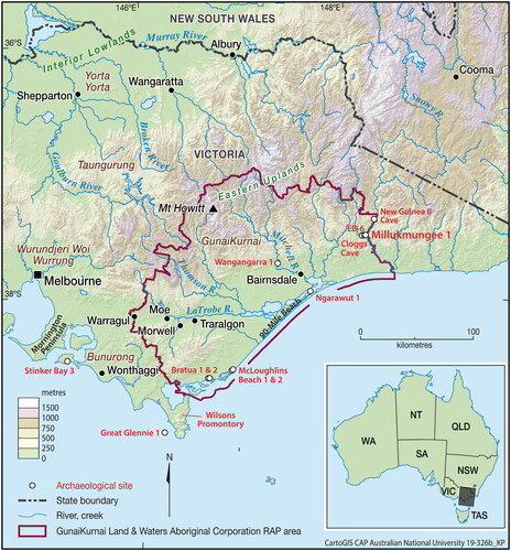
GunaiKurnai Country spans from the coast to Alpine elevations of Gippsland, eastern Victoria (). The stone artefacts of GunaiKurnai Country and nearby areas have received very little archaeological attention. Almost all of the published archaeological research on stratified stone artefacts in GunaiKurnai Country and nearby areas comes from excavations undertaken in the 1950s to early 1980s (Coutts Citation1967, Citation1970; Coutts et al. Citation1976; Flood Citation1973, Citation1974, Citation1980; Fullagar Citation2015; Gallus Citation1964; Gaughwin and Brennan Citation1986; Gaughwin and Fullagar Citation1995; Jones and Allen Citation1979, Citation1980, Citation1985; Ossa et al. Citation1995). The exceptions are Wangangarra 1, a site with only two excavated artefacts (Roberts et al. Citation2020); and Mialanes et al.’s (Citation2023) analysis from the 2019–2020 excavations at the special-purpose site of Cloggs Cave, a site with very few stone artefacts. How the stone artefact assemblages vary technologically, typologically, and functionally across the ecologically diverse landscapes of GunaiKurnai Country has never been investigated.
Figure 1. Study region showing location of published and recently excavated but currently unpublished archaeological sites in and near the GunaiKurnai Land and Waters Aboriginal Corporation Registered Aboriginal Party area.
The published studies began with Alexander (Sándor) Gallus’s excavation at rock shelter site EB-6 (East Buchan site 6, Victorian Aboriginal Heritage Register (VAHR) code 8522-0021) near the confluence of the Buchan and Snowy Rivers in 1958–1959. In applying for funding for a 14C age, Gallus submitted the following unpublished report on EB-6 to the Council of the newly established Australian Institute of Aboriginal Studies (AIAS, now AIATSIS) in Citation1964:
The excavation which was carried out in a rock shelter (designated by the Speleological Society of Victoria as EB6) during 1958–59, was the first stratified excavation conducted in Victoria, and a report on the results of this excavation awaits publication. Carbon has been obtained in sufficient quantity from Layers 3a (humus), 3b and 2. The excavation produced a large number of implements of well-defined types. For your reference a summary of this excavation is attached. A plan of a typical cross-section has been lodged with the Institute and may be seen on request ().
Figure 2. Alexander Gallus’s 1958–1959 section drawing (drawn by R.A. Bailey) of his excavation trench at rock shelter EB-6 (VAHR 8522-0021). (Courtesy of the Australian Institute of Aboriginal and Torres Strait Islander Studies).
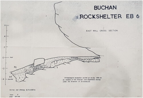
… The shelter faces North and would provide limited shelter against wind and rain. A large number of fireplaces were found, together with an abundance of stone implements. The stratification shows a sequence of three distinct industries.
Description of Layers:
Bedrock: Reddish clay, breaking into lumps when dry. Forme[d] over the uppermost level of the limestone. Contains a narrow culture layer with a sparse spreading of single bones and a few artifacts.
Layer 2: Powdery, deep chocolate soil, preserved only in patches. It merges gradually into Layer 3a. Contains a ‘microlithic’ industry.
Layer 3a: Deep brown to reddish brown soil, with an uneven accumulation of limestone debris at its base. This layer contains a flake and scraper industry.
Layer 3b: Humus which becomes brown in depth, merging into 3a. It contains a flake and scraper industry which favours white quartz as raw material. This Industry is associated with large pebble tools.
The flake and scraper industry in Layers 3a and 3b shows typological affinities to the Industry found in the first two layers of Koonalda Cave [which Gallus had also recently excavated, in South Australia].
Also in the southern foothills of the high country, just 3.8 km west-northwest of EB-6, Flood (Citation1973:286) excavated at Cloggs Cave in 1971–1972. Here she found 924 stone artefacts under the overhang outside the cave, and 70 inside the cave. She divided the deposit into two major phases, a Pleistocene ‘macrolithic’ industry of patinated pebble tools and steep-edged scrapers, and a ‘microlithic’ Late Holocene industry of small artefacts (Flood Citation1973:267). She found large core tools and scrapers in the deepest excavation levels both inside and outside the cave, and several geometric microliths and a single Bondi point in the uppermost levels outside (Flood Citation1973:270, Citation1974:175, Citation1980:259). However, these two distinct sets of artefact types occurred together in the disturbed area under the overhang outside the cave (Flood Citation1973:Figures 39–40). Two Late Holocene 14C ages were obtained from mid-depth in squares G and W of the excavations under the overhang outside the cave, putting into doubt an assumed Pleistocene age for the undated macrolithic artefacts found at similar depths.
David et al. (Citation2021) re-excavated and redated Cloggs Cave in 2019–2020. Mialanes et al. (Citation2023) reported on the 29 flaked stone artefacts newly excavated from square R31 inside the cave. In the deeper levels dating between 25,640–48,470 cal BP,Footnote1 the predominant raw material was the local cave limestone, whereas limestone was seldom used after 16,990 cal BP. Quartz was mostly used between 9290–17,260 cal BP. Quartzite and silcrete appeared between 12,040–14,060 cal BP, and volcanic rock between 10,720–12,420 cal BP. Freehand (unipolar) percussion was the most common technology used, and bipolar (anvil-rested) flaking was applied to quartz water-rolled pebbles between 12,040–14,930 cal BP. The retouching of stone artefacts was rare, with only a single artefact being retouched. The only formal tool type found was a small, thin portable grindstone used to crush and grind crystalline minerals and Bogong moths (Agrotis infusa), dated to c. 2000 cal BP (Stephenson et al. Citation2020). Cloggs Cave’s very small artefact sample size, the total absence of flaked stone artefacts from Late Holocene levels, and specialised use of the cave as a ritual domain (see David et al. Citation2021, Citation2024; Mialanes et al. Citation2023) does not permit broader generalisations to be reached for a regional stone artefact sequence.
Seventeen kilometres north-northeast of EB-6 and 18 km northeast of Cloggs Cave, Paul Ossa excavated 43.5 m2 under and near the entrance overhang of New Guinea II Cave in 1982–1985. This is a large limestone cave on the west bank of the lower reaches of the Snowy River. It is the only other published excavated site from GunaiKurnai Country within the highlands foothills. The stratigraphy of the main, >4.8 m-deep deposit [as based on the depth of the deepest 14C dating sample and published stratigraphy (Ossa et al. Citation1995:27, 28)] was unclear even at the time of excavation (‘Within the shelter […] there were no major continuous layers of sediment that could be recognised by any of the normal criteria (colour, texture, compaction, etc.))’ (Ossa et al. Citation1995:26). The 10 conventional 14C ages did not clarify the chronostratigraphy. The oldest 14C age, of 21,000 + 900/-800 BP (SUA-2222), is thus a minimum age for the archaeology (Ossa et al. Citation1995:28).
A total of 317 stone artefacts were excavated, 285 from under the entrance overhang. With very few exceptions, the artefacts were generally described as ‘amorphous’ and said to have been made from raw materials available from the nearby Snowy River bank (Ossa et al. Citation1995:29). Chert predominates, followed by other fine siliceous stones, quartz, limestone and volcanics. Most of the limestone artefacts came from the lower excavation units. A limestone pebble ‘double side scraper’ is a rare example of a retouched artefact. Ossa et al. (Citation1995:29) concluded that ‘there is some patterned change with depth’ as ‘there are more large lithics in the lower units’, although they also point out that:
There is a similar number of large artefacts in each of the units, with a greater quantity of small pieces in the upper two units. […] The small size of the pieces are similar in all units. These are what are normally called ‘chips’; small flakes and flake fragments resulting from occasional breakage, retouching and possibly use, all around a gram in weight.
Research from the 1960s through the 1980s in coastal Gippsland identified clearer temporal phases for the stone artefact assemblages. At Wilsons Promontory to the immediate west of the GunaiKurnai Land and Waters Aboriginal Corporation (GKLaWAC) Registered Aboriginal Party (RAP) area, Coutts (Citation1967:60, 1970) identified two major archaeological phases: an older phase (‘Yanakie A’: 6500–3000 BP) that consisted of a backed ‘blade’ industry (‘geometric microliths’) and retouched flakes made predominantly from non-local quartzite and local flint. This was followed by a later phase (‘Yanakie B’: 1000–0 BP) of flakes and large cores made from local quartz and flint and that included edge-ground axes made of ‘a dense dark grey fine-grained rock […] made from an altered basic rock of the serpentine type’ (Coutts 2967: Appendix 12.4).
At Great Glennie Island 7 km off the west coast of Wilsons Promontory, Jones and Allen (Citation1979, Citation1980) subsequently excavated the Glennie Island 1 rock shelter. They 14C-dated the occupation levels to within the past c. 1500 years (see Fullagar Citation2015 for a summary of Jones and Allen’s unpublished 1985 excavation report). The stone artefact assemblage was consistent with Coutts’ (Citation1970) Yanakie B assemblage that had been dated to 1000–0 BP (see above; we have left Coutts’ dating uncalibrated as the dates relate to phases rather than individual 14C ages). No formal tool types, such as backed artefacts or retouched flakes, were recovered from Glennie Island 1. Instead, the assemblage featured relatively large artefacts and the use of local quartz and introduced marine chert (‘flint’) (Fullagar Citation1986, Citation2015:221–222; Gaughwin and Fullagar Citation1995:45–46; Jones and Allen Citation1979:5).
Further to the west, Hilary Sullivan (Citation1981) conducted a survey of the Mornington Peninsula. She found a predominantly flake and blade industry (‘microlithic’ tradition) made largely from silcrete, chert, and quartz, which she suggested dates to the past 6000 years, presumably based largely on comparisons with Coutts’s work at Wilsons Promontory 130 km to the southeast (Sullivan Citation1981:96). Sullivan (Citation1981:91) identified numerous formal tool types in surface scatters, including backed ‘blades’ such as Bondi points and geometric microliths, flake scrapers and thumbnail scrapers. She also identified occasional isolated instances of an older lithic tradition consisting of pebble ‘choppers’ and large, steep-edged ‘horse-hoof’ cores. These latter artefact types were never associated with the ‘microlith’ scatters, and they all remained undated (Sullivan Citation1981:91).
To the immediate east of Mornington Peninsula, at Stinker Bay on Phillip Island in Western Port Bay, Gaughwin and Brennan (Citation1986) excavated a small rock shelter in 1983. The Stinker Bay 3 rock shelter excavation was small, totalling 1 m2 in area. Two 14C ages were obtained on charcoal, 250 ± 50 BP (Beta 7061) and 280 ± 55 BP (Beta 7062) for the top and bottom of the shallow marine shell-dominated archaeological deposit, respectively. At 95.4% probability, both these dates calibrate to ≤465 cal BP. A total of 10 stone artefacts were excavated. Four of six flakes were on flint, one on silcrete, and one on quartz. There was also a flint core, a basalt pebble used as a hammerstone, a silcrete pebble possibly used as a grindstone, and a unifacially flaked silcrete pebble. All raw materials were locally available at Stinker Bay.
Further to the east again and still along the coast, in the Gippsland Lakes and along the 90-Mile Beach within GunaiKurnai Country, Hotchin (Citation1990; Hotchin and May Citation1984) similarly identified distinct phases in the stone artefact assemblages. For the period from 4000 to 3000 BP, he noted that sites were dominated by silcrete ‘microliths’ such as backed ‘blades’ and burins (Hotchin Citation1990). The past 1000 years saw a disappearance of these formal tool types and an increasing use of quartz as a raw material (again, we retain Hotchin’s uncalibrated chronology as these are phases rather than individual 14C ages).
Summary of the stone artefact sequences
In short, most publications on the excavated stone artefacts of GunaiKurnai Country and nearby areas characterise or loosely mention that the stone artefacts come from one or other of two phases. These phases did not always correspond from site to site. Gallus’s excavation at EB-6, a limestone rock shelter, revealed a ‘microlithic industry’ dated to 2760 ± 100 BP followed by flake and scraper industries with large pebble tools and an increased incidence of quartz. The only two sites with Pleistocene deposits are both limestone caves, Cloggs and New Guinea II. Both have very few stone artefacts in the caves, with limestone predominating in the lowest levels. Flood characterised the Cloggs Cave assemblage as consisting of two distinct phases, a Pleistocene assemblage with steep-edged scrapers, large core tools, pebble tools, and a generally macrolithic industry, followed by a Late Holocene microlithic industry containing backed artefacts and other small artefacts—a reversed pattern to Gallus’s at EB-6, although the timeframes involved at the two sites were different. All three of the limestone sites from the southern foothills of the highlands occur within 18 km of each other.
The other excavated sites are coastal. At Wilsons Promontory, Coutts’s early phase (Yanakie A, 6500–3000 BP) of backed artefacts and retouched flakes predominantly of non-local quartzite and local flint was followed by a later phase (Yanakie B, 1000–0 BP) of flakes and large cores dominated by local quartz and flint—a two-fold division reminiscent of Gallus’s at EB-6. At Great Glennie Island, Jones and Allen saw large artefacts mainly of local quartz and flint dating to the past 1500 years, broadly consistent with Coutts’s Yanakie sequence. Hotchin’s work along 90-Mile Beach is also consistent with Coutts’s Yanakie schema, with an initial phase dated from 4000 to 3000 BP (within the Yanakie A chronology) containing silcrete backed artefacts and burins, followed by a most recent phase dated to the past 1000 BP when these artefact types disappeared and quartz became predominant.
Nevertheless, the chronostratigraphy of most sites remains problematic, and the sample sizes are generally very small. For all sites, the 14C dating that took place before the 2000s was relatively coarse-grained, with no site other than New Guinea II Cave (itself with very poor chronostratigraphic integrity and resolution) receiving more than five radiocarbon ages, irrespective of the age and duration of the individual deposits. In many cases also, the age of the archaeological phases are difficult to meaningfully calibrate to equivalent calendar years (i.e. convert ‘BP’ to ‘cal BP’), as the individual 14C ages received what today would be considered inadequate pre-treatment, and the conventional ages obtained during those research years before the advent of accelerator mass spectrometry (AMS) 14C dating usually required combinations of large amounts of charcoal originating from broad horizontal and vertical areas to meet requirements of sufficient sample size. Together, these limitations have led many contemporary researchers to question the precision, accuracy, and/or broader applicability of the purported archaeological phases (e.g. David et al. Citation2021; Rogers et al. Citationin press). Our excavations at the rock shelter site of Millukmungee 1 aim to address these issues by throwing some degree of chronological clarity on a new sequence that has reasonable numbers of flaked stone artefacts.
Millukmungee
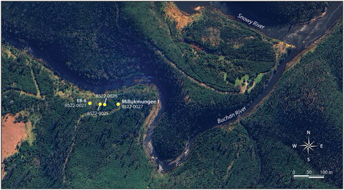
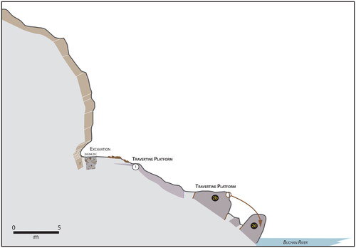
In 2017, GKLaWAC asked archaeologists from the Monash Indigenous Studies Centre at Monash University to investigate several places in GunaiKurnai Country. One of these is on the lands of the Krauatungalung clan, in an area called Millukmungee that refers to the grassy country along the banks of the Buchan River near its junction with the Snowy River in eastern Victoria where Gallus’s site EB-6 is located. Four small rock shelters are registered along the grassy slopes of Millukmungee in the State government’s Victorian Aboriginal Heritage Register. They were labelled shelters A, B, C, and D during the archaeological surveys undertaken on 5 May 1977, with official VAHR codes 8522-0021 (site EB-6, shelter A), 8522-0025 (shelter B), 8522-0026 (shelter C), and 8522-0027 (shelter D) ().
Figure 3. Aerial view of the four rock shelters at the base of the limestone escarpment at Millukmungee, with their VAHR site numbers.
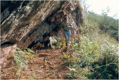
Two reported reconnaissance visits were made to these rock shelters by archaeologists in the 1970s, each apparently to assess their archaeological potential. Josephine Flood went to East Buchan in the early 1970s during her search for sites for her PhD studies, but she dismissed the rock shelters as being without promise: ‘It lies not far above the Buchan River and much of the earlier occupation deposit appeared to have been swept away by floodwater, but below the occupation of the Small Tool Phase were hints of Pleistocene occupation (Gallus pers. comm.). Not far away on the highest Arundel III terrace of the Buchan River … Gallus found in situ three pebble tools or “polyhedrons”, considered by him to have considerable antiquity’ (Flood Citation1980:254). Peter Coutts, Victoria’s State Archaeologist at the time, went to shelter C (VAHR 8522-0026) apparently in 1977 and dug a shallow hole; all we have is a photograph of the event, replete with spade, nearby sieve, and newly dug small square pit (). The official Victoria Archaeological Survey (VAS) recording form for the site, completed by Rudy Frank (then also with the VAS) on 5 May 1977, includes a brief note: ‘Small deposit some 25 cm deep good excavation potential’. A further, tentative attempt at determining the archaeological potential of the Millukmungee rock shelters also took place apparently on that same day, when a 1 m2 square was dug, again apparently with a shovel, this time in the eastern-most of the four rock shelters (shelter D, VAHR 8522-0027). That site’s recording form was again filled in on 5 May 1977 by Rudy Frank. The only record of this excavation is a brief note and sketch plan of the square pit on the form. In its entirety, the hand-written note states: ‘Test Pit 40 cm + deep’, and ‘Good excavation potential 40 cm + of deposit. Excavation time est[imated] 18 weeks’.
Figure 4. Peter Coutts and dog ‘Digger’ at rock shelter VAHR 8522-0026 at Millukmungee, probably in 1977. (Photographer unknown, courtesy of First Peoples – State Relations).
In 2019–2021, we undertook an archaeological excavation at ‘shelter D’, near the infilled ‘40 cm+’ pit of 1977. Since then, GKLaWAC have named the shelter Millukmungee 1. The excavation revealed many stone artefacts, a smaller quantity of animal bones, and an interesting pollen and burnt particle sequence that relates to cultural burning of the local vegetation; the cultural burning story will be reported elsewhere (Michael-Shawn Fletcher, personal communication 2022). Here we focus on the stone artefacts and animal bones, for what they reveal about site use and the nature and antiquity of the featured artefact types and their technologies. The stone artefacts are of particular importance for GKLaWAC because in recent years cultural heritage consultants working across GunaiKurnai Country have reported (in unpublished reports) many artefacts from cultural heritage surveys and salvage excavations, but seldom have their findings resulted in meaningful stories about the past, the Old Ancestors or Country. An absence or paucity of reliable information on the antiquity of artefact types and technologies for GKLaWAC Country, and indeed for all of eastern Victoria, means that baseline data on stone artefacts are sorely needed for this region. This is especially so given that the artefacts excavated from other sites in GunaiKurnai Country have been interpreted through largely culture-historical grand narratives of artefact traditions based on discoveries made hundreds or thousands of kilometres away, and that may or may not have close relevance for this region. What are needed are well-dated sequences to determine the relative and absolute chronologies of stone artefact types, technologies, raw materials, and their variabilities that apply to GunaiKurnai Country. If lithic resourcing at least in part relates to the accessibility of sources, or to partly or fully finished artefacts obtained through trade and social contacts, then we need to determine patterns and trends in raw material, types, and technological practices through time for each region, one at a time, rather than blindly applying geographically broad or pan-Australian patterns that do justice to no single location, habitat or Country. In this sense, it is important to remember that the choice of raw material at least in part relates to its cultural value, so that the changing incidence of raw materials at a site and across a region may reveal details of local and potentially changing or diverse Aboriginal philosophies of stone. Ethnographically, across Australia such relational ontologies are connected to the power or essence of the living stone, not just to its mechanical properties, such as hardness, or to the ‘functional’ efficiencies that it may proffer to the researcher (for discussions of Aboriginal philosophies and relational ontologies of stone across Australia, see e.g. Ash et al. Citation2022; Bradley Citation2008; Brumm Citation2010; Jones and White Citation1988; McBryde Citation1984; Paton Citation1994; Taçon Citation1991).
Millukmungee 1
Millukmungee 1 is found at the base of an 80 m-long limestone escarpment on the western bank of a northwest to southeast-oriented section of the Buchan River, 700 m upstream from the Buchan–Snowy Rivers junction, as the crow flies ( and ). The base of the escarpment is perched 10 m above the Buchan River. The escarpment is marked by numerous niches and alcoves, the rock shelter of Millukmungee 1 being among the largest.
Figure 5. Millukmungee escarpment and slopes to the Buchan River, 18 May 2019. Top: Western end of the escarpment, showing site EB-6 (VAHR 8522-0021). Bottom: Millukmungee 1 (VAHR 8522-0027) at eastern end of the escarpment, excavation in progress (photos by Bruno David).
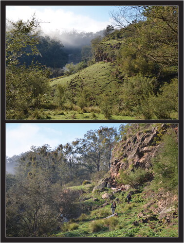
Figure 6. Simplified geological map of the Millukmungee 1 study area (figure by Jean-Jacques Delannoy, after Orth et al. Citation1995).
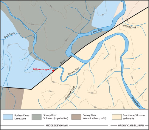
Millukmungee 1’s configuration is the result of a long morphogenic evolution (Delannoy et al. Citation2020; Webb et al. Citation1992). The originally offset topographies that resulted from faulting and tectonic movement are today no longer evident. Irrespective of their lithology (limestone, sandstone, volcanics), all the major geological formations of the region are now of similar elevations with summits c. 200 m above sea level, underlining the millions of years of erosion. The shape of the landscape mainly relates to the incision of the Snowy and Buchan Rivers and their tributaries, along with karstification of the limestone bedrock. The Buchan River flows southeastward through the study area, following the contact zone of the limestone (west bank) and volcanic bedrock of the Snowy River Formation (east bank) ().
Millukmungee 1 is located close to the Lucas Point fault-line (). This northeast–southwest trending regional fault-line is responsible for the anomalous contact between three geological formations: the Buchan Caves Limestone (Middle Devonian), volcanics of the Snowy River Group (Middle Devonian), and sandstone formations (Ordovician–Silurian). A perennial karst spring some 12 m above the Buchan River’s thalweg (lowest part of the river’s channel) is positioned precisely at this triple juncture point. The presence of the spring is important for understanding the configuration of the slope between the rock shelter and the Buchan River. The slope consists of a series of stepped platforms descending towards the river ( and ). This stepped topography developed through the deposition of large masses of travertine by water coming from the spring. The thick layers of travertine have long contributed to the stabilisation of the slope by protecting it from fluvial erosion. It has also played a role in the protection of the limestone escarpment. The Buchan River has not undercut the rock shelter; the shape of the escarpment has remained largely unchanged over long periods of time, with the width (distance between back wall and dripline) of the overhang having been reduced through time largely by gravitational processes (rockfall along its outer edge). Boulders at the foot of the escarpment, as revealed in the archaeological excavations (see below), are the main signs of such gravitational collapse.
Figure 7. The Millukmungee 1 landscape looking upstream. Note the position of the spring at the anomalous contact (fault) between the Buchan Caves Limestone and the Snowy River Volcanics. The stepped flats of travertine (Travertine Platforms 1 and 2) formed through karstic dissolution and redeposition of the limestone (photo and figure by Jean-Jacques Delannoy).
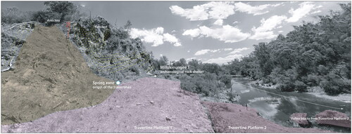
Figure 8. Plan of Millukmungee 1 (figure by Jean-Jacques Delannoy).
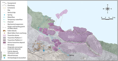
The geomorphological study of the site, and the dating carried out on the travertines, indicate that the rock shelter acquired much of its current configuration before c. 40,000 years ago. Since then, the shelter has continued to evolve, especially as the overhang receded through rockfall. Protected from fluvial erosion since then, aeolian sediments, secondary carbonate deposits, and rockfall have accumulated around and under the rock shelter, as evident from the site’s excavated sediments (see below). The present floor of Millukmungee 1 includes the area under the rock shelter and the flat floor that extends beyond the overhang. The floor of the site is c. 6 m wide (along the axis perpendicular to the dripline) and 10 m long (along the axis of the dripline), with 1.0 m of this width and 2.5–3.0 m of this length being under the overhang. Beyond the overhang, the flat floor extends to a shallow ‘balcony’ that sits over an older, partly buried travertine platform perched above the river (). The upper part of the travertine against the rock shelter’s back wall has been U-series dated to 39,988 ± 7327 years ago, giving a minimum age for the rock shelter’s existence.
Figure 9. Cross-section spanning the limestone escarpment, Millukmungee 1 rock shelter, slope and Buchan River channel. The rock shelter is perched above the travertine platform that began forming before 40,000 years ago (figure by Jean-Jacques Delannoy).
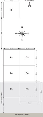
Initially, three non-contiguous 50 × 50 cm excavation squares—P3, P5, and P8—were aligned perpendicular to Millukmungee 1’s rear wall, to establish the stratigraphy both inside and outside the dripline and to explore the use of space. Square P3 was set ∼50 cm from the back wall to avoid areas of sediment mixing against the wall. Sediments under the overhang were found to be significantly less rocky than those in the outer squares. Additional 50 × 50 cm squares were then added to the east (O3, O4, O5) and west (P4, linking P3 with P5) to create a larger, contiguous pit to access the deeper layers (initially, square O3 was 65 × 65 cm in size, but was reduced to 50 × 50 cm below XU48) ().
Figure 10. Schematic plan of Millukmungee 1, showing positioning of the excavation squares (figure by Bruno David).
Excavation methods
Six juxtaposed 50 × 50 cm squares set as a 1 × 1.5 m pit were excavated to a maximum depth of 175.9 cm (square O4) and 175.3 cm (square O5). The pit’s long axis is oriented perpendicular to the back wall, with the outer squares (O4, P4, O5, P5) being wholly outside the overhang ( and ). Squares O3 and P3 were offset c. 50 cm north of the back wall. A further 50 × 50 cm square, P8, was dug 1 m to the north of P5, but only went down 51.3 cm before massive rockfall caused the excavation to be discontinued.
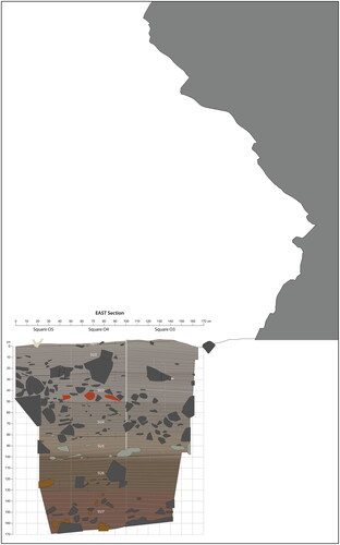
Figure 11. South–north transect from back wall across the main pit (squares O3–O5), showing the position of the overhang above the pit at Millukmungee 1. See for details of the excavated section (figure by Bruno David).
Excavation progressed in average 2.3 cm-thick artificial Excavation Units (XUs or ‘spits’) following the stratigraphy (). Bedrock was not reached in any part of the excavation. Stone artefacts, faunal remains, and other cultural materials ≥2 cm long, and a small number of pieces of charcoal from each XU were individually collected and their position within the square recorded to 1 cm horizontal and 1 mm vertical precision. Sieving was undertaken dry on-site in 2 mm-wide mesh, and again, this time wet, in the Monash University laboratories. All cultural materials and charcoal retained in the sieves were sorted and analysed. Bulk sediment samples were collected from each XU of each square. Pollen samples were collected at 5 cm depth intervals after completion of the excavation. All sorting of the sieved excavated sediments took place under controlled conditions at the Monash Indigenous Studies Centre archaeology laboratories.
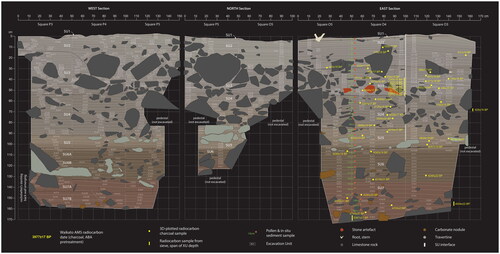
Figure 12. Section drawings of Millukmungee 1 squares O3–O5 and P3–P5. The 14C ages were back-plotted onto the sections. The white vertical line on the east section between squares O3 and O4 indicates where the upper part of square O3 was offset outwards by 15 cm down to the base of XU48 (figure by Bruno David).
Stratigraphy
Seven SUs were identified (numbered from SU1 at top to SU7 at bottom) ( and ). They are all compact and consolidated clayey loams (SU1, SU4), sandy clayey loams (SU2, SU6, SU7), or sandy loams (SU5); SU3 varies with depth from clayey loam to sandy clayey loam. Rockfall is abundant, especially in SU2–SU4, although it is present throughout. The base of many rocks lie flat, those that do not usually lean on other rocks, indicating that they typically fell and remained on palaeosurfaces rather than critically churning up the compact underlying sediments when they fell (the 14C age sequence confirms this, see below). SU5 and, especially in squares O3 and P3 closest to the back wall, SU6 are rich in travertine, with the lower levels of SU6 containing calcium carbonate concretions that are denser than the travertine. The interfaces between SUs are all gradual, typically taking place over 3–10 cm depth. In squares O3 and P3 (the squares adjacent to the back wall), the SU1–SU2, SU2–SU3, SU3–SU4, and SU6–SU7 stratigraphic transitions are blurred within 80–90 cm north of the out-sloping back wall. The SU5–SU6 transition is clearly visible within c. 25 cm of the back wall (). pHs hover around neutral to slightly alkaline, ranging from 6.91 to 8.43 and generally increasing with depth. Further details of the stratigraphy are given in .
Figure 13. Millukmungee 1 main pit after completion of excavation, 24 January 2021. Left: Squares O3–O5 and P3–P5 pit and back wall. Top-right: East section, squares O3–O5. Bottom-right: West section, squares P3–P5 (photos by Bruno David).
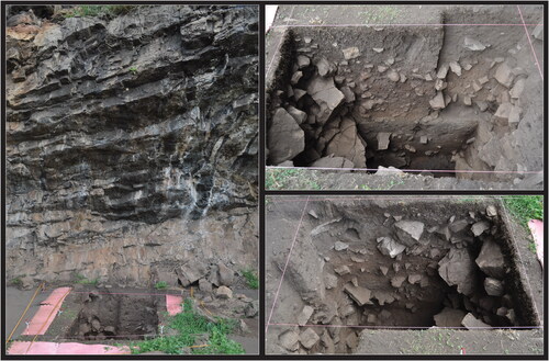
Table 1. Description of Millukmungee 1’s stratigraphic sequence.
Radiocarbon ages
We obtained 33 AMS 14C ages on individual pieces of charcoal () from squares O4, O5, P4, and P5. All 14C ages were calibrated using OxCal v4.4 (Bronk Ramsey Citation2024) with the Intcal20 curves (Reimer et al. Citation2020) and are reported at 95% probability in the text (, ).Footnote2 A further 14 ages on individual pieces of charcoal came from squares O3 and P3, making for a total of 47 AMS 14C ages. Thirty-six of the dated charcoal samples were plotted in three dimensions and collected in situ; the other 11 came from the sieves. Only the results from squares O4, O5, P4, and P5 underwent Bayesian modelling, to focus the Bayesian model on a vertical sequence. Other than near the top of squares O3 and P3, the chronostratigraphy is consistent across all squares. To provide a temporal outline for the sequence, we used Bayesian Sequence analysis whereby sequential 14C ages are constrained by prior stratigraphic information, in this case depth, between start and end boundaries (Bronk Ramsey Citation2009a). Stratigraphic units were not used to group dates into phases because the gradual soil development was punctuated by sudden change events, resulting in intermixing in some units. To test the internal consistency of the calibrated ages, we used a General t-Type outlier model with a prior outlier probability of 0.05. This methodology provides a probabilistic measure of the degree to which samples appear to be outliers and downweighs the influence of those ages on the model (Bronk Ramsey Citation2009b).
Figure 14. Bayesian age model for 14C ages from Millukmungee 1 grouped by SU. Red = SU7; Blue = SU6; Orange = SU5; Green = SU4; Black = SU4–SU3 interface to SU3–SU2 interface; Yellow = SU3–SU2 interface to SU2. Solid distributions represent boundary ages after Bayesian modelling. The notation [O:4/5] indicates a 4% posterior probability of being an outlier in the model (figure by Fiona Petchey).
![Figure 14. Bayesian age model for 14C ages from Millukmungee 1 grouped by SU. Red = SU7; Blue = SU6; Orange = SU5; Green = SU4; Black = SU4–SU3 interface to SU3–SU2 interface; Yellow = SU3–SU2 interface to SU2. Solid distributions represent boundary ages after Bayesian modelling. The notation [O:4/5] indicates a 4% posterior probability of being an outlier in the model (figure by Fiona Petchey).](/cms/asset/e08c87b4-14bc-46b5-9839-d7cd3efbbea0/raaa_a_2362936_f0014_c.jpg)
Table 2. AMS 14C charcoal ages from Millukmungee 1.
Table 3. Results of Bayesian Sequence model.
Our model calculates five minor outliers (those with posterior outlier probabilities of between 6 and 10%; Wk-57092, Wk-57098, Wk-52792, Wk-52298, and Wk-52578). There are two moderate outliers (outlier probabilities of 26 and 39%; Wk-52793 and Wk-57100) and seven major or 100% outliers (Wk-57101, Wk-57099, Wk-52791, Wk-57097, Wk-57096, and Wk-57095). Six of these major outliers are charcoals from SU3 and have 14C ages that are both older and younger than their relative depth context. As both older and younger ages are outliers, the age-depth reversals are unlikely to be due to inbuilt age in the charcoal, and more likely to have been caused by rock fall. The impact of these outliers on the model can be assessed by the convergence values generated (see ). These convergence values should be >95%; lower values indicate many different incompatible solutions to the model at these points (Bronk Ramsey Citation2009a). Low convergence values are identified for seven of 13 ages within SU3 (Wk-52791, 57096, 57097, 57098, 57099, 57100, and 57101) between depths of 55.9 cm (SU4/SU3 boundary) and 49.9 cm below surface within square O4. Ultimately, this large number of major outliers impacts the start and end boundary ages for Millukmungee 1, as indicated by low convergence values of 92% for each (for the OxCal code, see Supplementary Table 1, in Supplementary Materials).
Overall, this model suggests that deposition at the base of the excavated pit started after 6920 cal BP with a near-continuous sequence and gradual build-up of the deposit until c. 3690 cal BP. Only three obvious ‘gaps’ are evident in the sequence: between XU35 and XU38 within SU4 (c. 3690 cal BP to 2700 cal BP; at 66.4 and 73.8 cm depth); at the SU4–SU3 boundary (after 2100 cal BP) where a significant period of disturbance has occurred—at the time of the three large stone artefacts coloured red in the cross-section (see )—possibly destroying part of the sequence at this point. The last gap occurs after the deposition of charcoal in XU21 (between 830 cal BP and 610 cal BP; Wk-57093 and Wk-57092). The final evidence of use at the site continues until c. 140 cal BP.
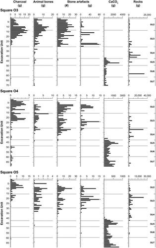
Cultural materials
The main archaeological evidence for occupation of the site is the stone artefacts, with lesser traces in the faunal remains and charcoal. No hearths, hearth stones, or concentrations of burnt sediment were recovered despite the presence of charcoal in every square, particularly in SU2 and SU3 (; Supplementary Figure 1). Charcoal is most likely to be the result of landscape fires, both cultural burning and bushfires; the vegetation at the site burned during the 2019–2020 Gippsland bushfires, accounting for the charcoal in the uppermost level (Buettel et al. Citation2023). Charcoal is generally sparse in SU4–SU7, increasing sharply in upper SU3. This temporal trend broadly, but not entirely follows the depositional trends of the stone artefacts and animal bones, which begin their peak values near the top of SU4 as well. Overall, the distribution of cultural materials indicates that human occupation was sporadic or infrequent between the formation of SU7 and lower SU4. The oldest stone artefact was found in square P5 XU67 (in SU7B), at a level dating to sometime between 5590–5050 cal BP (this is the calibration uncertainty range). Very few stone artefacts and animal bones were then discarded in SU6 and SU5, but the numbers increase notably in the upper half of SU4, after 2340–2030 cal BP. This timing corresponds also with the cessation of calcium carbonate (CaCO3) concretions, signalling that the floor in this part of the site became drier. Stone artefact discard peaks at or immediately after the SU3–SU4 interface, c. 1960 cal BP, and again during the first half of SU2, after 290 cal BP. The frequency of stone artefacts decreases abruptly in upper SU2, during the early colonial period (which in this region begins in the 1840s).
Figure 15. Frequency of cultural materials, calcium carbonate (CaCO3) concretions and limestone rocks from rock fall, squares O3, O4, and O5. Square O3 is under the overhang, O4 and O5 progressing furthest out from the overhang. *In O3, presence of a large hornfels core in XU28 weighing 302.0 g for a total weight of 304.2 g; in O4, presence of a large quartz core in XU24 weighing 274.9 g for a total weight of 275.0 g; in O5, presence of a large hornfels core in XU21 weighing 266.2 g for a total weight of 267.3 g (figure by Jerome Mialanes and Bruno David).
The stone artefacts
Assemblage size and raw materials
A total of 1515 stone artefacts weighing 5428.1 g were recovered from the seven excavated squares. The bulk of these were found in SU2 and SU3 (). The assemblage comprises six different raw materials. Quartz predominates in each square, accounting for 89.2% (N = 1349) of the entire assemblage by number (). The quartz varies from opaque to translucent to transparent. Quartz was, for the most part, obtained from riverbeds (a secondary source). Ninety-eight percent (N = 173) of the cortical surfaces of the quartz artefacts are water-rolled. The closest secondary source of quartz is the bed of the Buchan River, just a few metres from the site. In one rare instance, the recovery of a large quartz block indicates that people also targeted quartz veins.
Figure 16. Total number, weight and relative frequency (% by number and by weight) of artefacts by raw material, by SU, Millukmungee 1 (figure by Jerome Mialanes).
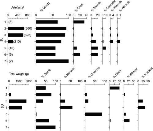
Silcrete is the second-most common raw material by number (N = 76). It is also a common raw material in the region, with two reported quarries south of the township of Buchan, one 9.8 km away near the headwaters of Tara Creek, and the other 16.8 km to the south (Fresløv Citation2021; Hunt Citation1993).
Chert is the third-most common material by number (N = 33). Chert artefacts have been found in other archaeological assemblages of the region (Hunt Citation1993; Mialanes et al. Citation2023; Ossa et al. Citation1995; Roberts et al. Citation2020; Stone Citation2013), although they have not been attributed to any specific source(s). Chert sources can be found in many parts of Gippsland, such as the Wonnongatta Valley, Nowa Nowa, and Toora (e.g. Bell Citation1959; Miezitis et al. Citation2000; Moore et al. Citation1998).
Quartzite artefacts also occur in small quantities (N = 30). The closest known source is c. 35 km to the north at Campbells Knob, along the Snowy River east of Gelantipy.
Hornfels artefacts (N = 19), made from fine-grained metamorphic rock found amidst the suite of raw materials that make up the Snowy River Volcanics, also occur at Millukmungee 1. Hornfels is found as cobbles in the Buchan River bed near the site. A few volcanic cobbles were also recovered from the excavation. Although hornfels and volcanic artefacts are few, they dominate parts of the assemblage by weight due to their large size ().
The range of raw materials used varies little through time. All raw materials except hornfels and volcanics (N = 4) are found through much of the sequence; hornfels and volcanics only occur in SU4 and above. Subtle changes in raw material use are nevertheless apparent. Excluding SU1 and SU7, both of which have very few artefacts (N = 3 and N = 2, respectively), there is a decline in the use of raw materials other than quartz through time (, Supplementary Figure 2). Results from a chi-squared test indicate that these changes are not due to chance; there is a statistically significant relationship [χ2 (df = 3) = 52.3, p < .001] between raw material frequency and SU.
Table 4. Relative frequency (%) and raw numbers (in brackets) of quartz vs. other raw materials, by SU.
The Millukmungee 1 stone artefacts are dominated by unretouched quartz flakes (N = 891), accounting for almost 67% of the assemblage (). Bipolar percussion is restricted to quartz, with bipolar flakes the second-most common fracture type, representing 16% of the total stone artefact assemblage.
Table 5. Fracture and further reduction types by raw material.
Relating knapping events to assemblage size can be problematic when a range of reduction techniques is used. Quantifying the Minimum Number of Flakes (MNF) in an assemblage is more useful than raw stone artefact numbers, as the former removes some of the background noise generated by broken flakes. A version of Hiscock’s (Citation2002a) MNF formula is here applied. The following formula was used to calculate the MNF of each raw material for each SU ():
Table 6. MNF by raw material, by SU.
A minimum of 646 flakes were discarded at Millukmungee 1 (as determined by the MNF calculations), with 91% (N = 586) occurring in SU2, SU3, and SU4. Given that 646 flakes were recovered from seven excavated squares and that they accumulated over more than c. 5000 years, a relatively low frequency of discarding and/or knapping events occurred in this part of the site.
Reduction intensity
Quartz cores and quartz manuports vary greatly in size. The smallest quartz nodule, a manuport from square P8 SU2 (XU5 in situ #4) (), measures 25 × 16 × 13 mm and weighs 7.4 g. Its water-rolled surface (cortex) is like that of quartz bipolar cores and flakes. This similarity in size between the manuport and the bipolar flakes, as shown in , suggests that nodules of this size were intentionally selected for reduction. Additionally, the assemblage includes much larger pebbles chosen for flaking, as indicated by the two largest quartz cores, which are of very similar sizes. Each core weighs between 253–275 g and measures between 67–88 mm long, 56–72 mm wide, and 41–54 mm thick (one of them is shown in ). Both are multi-platform freehand cores displaying four striking platforms.
Figure 17. Quartz artefacts from Millukmungee 1. (A) Multiplatform freehand core (P3 SU3 XU31). (B) Bipolar core (O3 SU3 XU16B). (C) Bipolar core (P4 SU2 XU15). (D) Bipolar core on flake (O3 SU2 XU5). (E) Manuport (P8 SU2 XU5). (F) Bipolar flake (P5 SU3 XU29) (photos by Steve Morton).
With such a large range of tool-stone sizes, it is not surprising that freehand (unipolar) and bipolar percussion were both used. Bipolar percussion was restricted to the smaller nodules with insufficient inertia for freehand (unipolar) percussion, and, in a single instance from SU2, for repurposing flakes as bipolar cores (). If required, and if core volume and geometry allowed, bipolar cores were further reduced by rotating 90°. Out of 45 bipolar cores (e.g. ), nearly a quarter (22%, N = 10) show evidence of rotation. Extending the use-life of bipolar cores by rotating them 90° is also reflected in the mean weight (3.2 ± 3.7 g) and mean maximum length (19.1 ± 9.3 mm) of the rotated bipolar cores, which are lighter and smaller than the non-rotated bipolar cores (mean weight 9.4 ± 19.7 g, mean length 23.1 ± 14.3 mm). While it may be surprising that people practised core rotation on a relatively abundant locally available quartz, water-rolled quartz nodules were small, and extracting more cutting power from flakes using core rotation would save time and energy compared to tool-stone replenishment. In addition, bipolar core rotation is easily implemented and does not require any additional steps apart from assessing the core morphology and volume. Nevertheless, evidence of core rotation on bipolar cores and complete flakes is not predominant, with similar levels of rotation observed from SU4 to SU2 (). A series of chi-squared tests comparing 90° rotations on bipolar cores and bipolar flakes between SU2 and SU3 (the SU4 sample was too small) reveal no significant correspondence between degree of bipolar rotation and SU, either for bipolar cores (χ2 = 0.90, df = 2, p = .34) or for bipolar flakes (χ2 = 0.26, df = 2, p = .61). Neither did the weight of bipolar cores significantly differ between SU2 (mean = 4.7 ± 5.4, N = 19) and SU3 (mean = 12.8 ± 24.7, N = 21) (Mann–Whitney test U = 192.5, p = .86). Overall, these results suggest consistent practices of quartz production without significant changes in reduction techniques over time.
Table 7. Presence or absence of 90° rotation on quartz bipolar cores and bipolar flakes, by SU.
All other raw materials underwent freehand (unipolar) percussion only. Hornfels artefacts were manufactured on-site, as evidenced by the recovery of five single-platform cores. The cores have large cortical surfaces. They average 462 g in weight and 99 × 80 × 44 mm in size (e.g. ). Apart from one core, all cores were discarded at an early stage of reduction. Based on the small number of hornfels cores and flakes recovered (N = 19), only a tentative description of the reduction method can be proposed. Flaking proceeded from a natural platform, generally located where the pebble was at its thickest. One of those very first flakes removed from a core (such as the one in ) is shown in . The flake scar on the core subsequently served as a new striking platform. As reduction continued, the core would progressively become smaller, such as that shown in . At this stage, the flattest sides of the pebbles were used as striking platforms. The resulting flakes are small (with lengths equivalent to the pebble’s smallest dimension) and they inherited the pebble’s cortical surfaces on both proximal and distal ends when removed from the middle part of the core (), or an entire lateral margin on top of the proximal and distal end when removed from the edges of the core (). Non-cortical flakes are rare (), which is most probably due to cobbles not being intensively reduced.
Figure 18. Hornfels artefacts. (A) Single platform core (East wall in situ #2). (B) Single platform core (P3 SU4 XU37). (C) Opposed platform core (O5 SU3 XU21). (D) Cortical unipolar flake (P5 SU4 XU33). (E) Cortical unipolar flake (O3 SU3 XU18). (F) Cortical unipolar flake (P5 SU4 XU34). (G) Unipolar flake (P4 SU2 XU10) (photos by Steve Morton).
Only one, large core was recovered among the chert artefacts (East wall #3, in O5 SU3 XU29). It weighs 631 g and measures 100 × 78 × 57 mm. The presence of numerous inclusions is probably the cause of its early discard.
Despite the recovery of 76 silcrete artefacts, no cores were found. Since only cores made of quartz, hornfels, and chert were recovered, stone artefacts made from other raw materials (silcrete and quartzite) were either brought to this part of the site already made, or their cores were retained for further use elsewhere.
Discussion of the stone artefacts
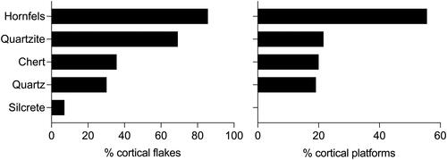
Cortex occurs on 19% (N = 290) of the entire lithic assemblage. Proportions of cortical flakes do not noticeably change through time, ranging between 29% (SU3) and 31% (SU2 and SU4). Cortex on the surfaces of complete flakes and on platforms are more frequent on locally available quartz and hornfels (). The presence of cortex on quartz (both unipolar and bipolar) and hornfels (unipolar) cores, and the recovery of numerous flakes with cortex covering their entire dorsal surfaces, indicate that the initial stages of reduction took place on-site. Many small quartz flakes and flake fragments were recovered from the excavation, indicating that tool manufacturing events also occurred on-site.
Figure 19. Proportions of complete flakes displaying cortical surfaces and cortical platforms (figure by Jerome Mialanes).
The weight and size of complete flakes vary greatly between raw materials (Supplementary Table 2). These differences are the result of (1) tool-stone size and morphology; (2) reduction technique; (3) reduction intensity; (4) reduction stages performed on-site; and (5) which flakes were discarded on-site or carried away. While small sample sizes hamper chronological comparisons for most raw materials, the quartz sample size is sufficient. The weight and dimensions of complete unipolar (Supplementary Table 3) and bipolar quartz flakes (Supplementary Table 4) do not vary significantly, suggesting that no significant changes took place in reduction intensity between SU2, SU3, and SU4, i.e. from 2340–2030 cal BP to colonial times in the mid-nineteenth century CE.
How much investment was placed in preparing the striking platform can give an indication of the type of raw materials people wanted to conserve. Greater proportions of focalised platform surfaces (where the platform’s area is equal to or smaller than the area of the ringcrack) and complex platform surfaces (facetted platforms) were more frequent on materials known for their superior flaking qualities, such as chert and silcrete (). This greater care in platform preparation implies that people maximised silcrete and chert flake production. Other attempts to conserve raw materials included overhang removals as a way of controlling platform angles and enabling successful flake detachment. Overhang removal was found in higher proportions on silcrete and chert ().
Figure 20. Proportions of focalised platforms, complex platforms, and overhang removal, by raw material (figure by Jerome Mialanes).
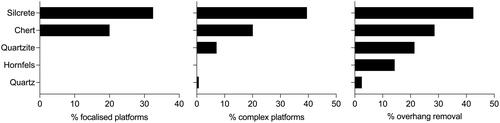
Raw materials that were preferentially conserved should show greater reduction intensity. One way of measuring reduction intensity is by counting the number of flake scars >10 mm long on the dorsal surfaces of complete flakes: everything else being equal, the number of scars on dorsal surfaces should increase with reduction, noting also that as artefact surface areas become smaller, less dorsal surface area becomes available for dorsal scars to accumulate (Clarkson Citation2002, Citation2005). The low number of flake scars on hornfels (mean 1.4 scars), quartz (mean 1.3 scars), and quartzite (mean 1.1 scars) indicates low reduction intensity. On the other hand, chert and silcrete show greater reduction intensity with higher numbers of flake scars (each with a mean of 2.3 scars).
The retouched assemblage
Only 3% (N = 39) of flakes (either complete or broken) show evidence of retouching. However, a look at raw material variations in retouching provides a different picture (). The low overall proportion of retouching is due to the large quantity of quartz flakes produced in SU2 and SU3 (1960–1270 cal BP to colonial times in the mid-nineteenth century CE), which for the most part were left unretouched. With 29.8% of its flakes retouched, silcrete is the most retouched material. Fine-grained siliceous materials were more often retouched than other raw material types. Clearly, people wanted to extend the use-life of silcrete artefacts, while other raw materials (e.g. quartz) were used in a more expedient manner (discarded after use, although some were selected for retouching). The overall low quantity of retouched artefacts can be attributed to the small quantity of fine-grained materials (e.g. silcrete and chert) in the entire lithic assemblage.
Figure 21. Proportions of retouched flakes, by raw material (figure by Jerome Mialanes).
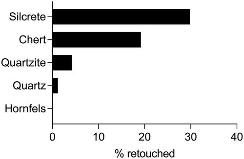
If we exclude SU5 and below because of their small sample sizes, it is in SU4 that the higher proportion of retouched artefacts is found. This is because SU4 contains the highest number of silcrete artefacts; this is a time when quartz manufacture had not yet reached the heights observed in SU2 and SU3.
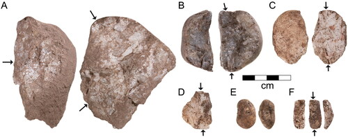
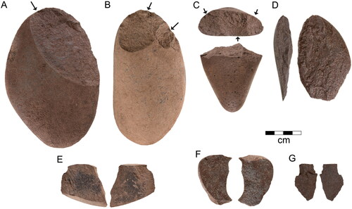
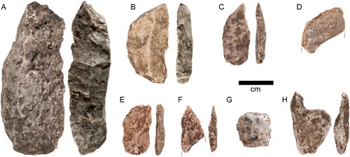
A few formal tool types occur among the retouched flakes. The most common are four complete backed artefacts () and two broken ones (). We follow Hiscock’s (Citation1993:70) definition of backed artefacts as ‘flakes presenting one or more blunted or steeply retouched margins. The steep retouching is sometimes bidirectional from the use of bipolar or anvil-rested techniques’ (Hiscock Citation2002b). All the Millukmungee 1 backed artefacts are on silcrete. The backing was done by bipolar anvil flaking on three of them () (note, however, that while the backing on the silcrete backed artefacts was produced through bipolar flaking, the backed artefacts themselves are not bipolar flakes). The backed artefacts include a crescentic geometric microlith and an elouera; all the others are small and irregular in shape. The earliest backed artefact is of irregular shape and came from square P4 (SU6A XU51) at a level dating to 4570–4440 cal BP (). All the other non-elouera backed artefacts (N = 4) were found in SU4 or SU5 and date to between 4570–1940 cal BP. The elouera () is much more recent. It came from P4 (SU2 XU8) and dates to after 290 cal BP. We are not aware of eloueras having previously been found in GunaiKurnai Country. The ages of the non-elouera backed artefacts, and of the elouera, are consistent with McCarthy’s (Citation1948, Citation1964) and Hiscock and Attenbrow’s (Citation2005) ‘Eastern Regional Sequence’.
Figure 22. Retouched artefacts. (A) Large silcrete backed flake (elouera) (P4 SU2 XU8). (B) Silcrete crescentic geometric microlith (backed flake) (P3 SU5 XU60). (C) Silcrete backed flake (P4 SU4 XU34). (D) Silcrete backed flake (P4 SU6A XU51). (E) Silcrete backed flake (O4 SU4 XU32). (F) Silcrete backed flake (P5 SU4 XU33). (G) Crystal quartz thumbnail scraper (O5 SU6 XU55). (H) Quartz notched tool (P5 SU3 XU30) (photos by Steve Morton).
Hiscock (Citation2014:128–129) investigated the degree of symmetry for backed artefacts across Australia, using an index of symmetry (BASI or Backed Artefact Symmetry Index) (see also Low Citation2015). He suggested that backed artefacts are asymmetrical along the coast and become more symmetrical inland. His preliminary map of geographical variations in backed artefact symmetry predicts a BASI ranging between 0.70–0.75 for the Buchan region. Here we have calculated a BASI ranging from 0.72 to 0.94 for the four complete backed artefacts from Millukmungee 1, and an average of 0.86 ± 0.10, indicating they are generally very symmetrical. In contrast, Theden-Ringl and Langley (Citation2018) reported an average BASI of 0.54 ± 0.18 (N = 7) for the Mid- to Late Holocene occupation of Wee Jasper 99, an inland site 260 km to the north of Millukmungee 1, well beyond GunaiKurnai Country in NSW but at a similar elevation. Theden-Ringl and Langley (Citation2018:152) also noted that backed artefacts from Wee Jasper 99 tend to become more symmetrical with time.
Backing flakes—the by-product of the backing process (see Way and Pope Citation2018)—were not found in the assemblage at Millukmungee I, indicating that the backing process took place elsewhere and that the backed artefacts were brought to this part of the site already manufactured.
Although quartz artefacts were rarely retouched, a few of those need special mention. They include a notched tool made from milky quartz () in SU3. A thumbnail scraper made of crystal quartz () was found in SU6, at a level dated between 4850–4450 cal BP. This is the only example of crystal quartz in the assemblage.
The faunal assemblage
The Millukmungee 1 excavations yielded 8515 bones, each of which was examined for evidence of burning and mode of accumulation. Most of the excavated bone came from squares O3 and P3 (39.32 and 33.75%, respectively), the only two squares positioned under the overhang. This may have provided protection against weathering or other diagenetic processes, or it may indicate that bones had mainly accumulated in the shelter proper.
Calcined bone makes up <25% of the bone from any XU of squares O3 and P3 (Supplementary Table 5). Squares O4, O5, P4, P5, and P8 all appear to have higher percentages of calcined bone, but this is strongly influenced by their small sample size. Bone can only become calcined when burnt at ≥700 °C, or at a lower temperature for an extended period of time. Ground-level fires that burn at very high temperatures or for an extended duration are almost always managed by people. However, much of the bone shows evidence of having burned at low temperature (180–200 °C), colouring it brown (Supplementary Table 5). This is most commonly caused by landscape fires or when fireplaces are built on top of bone-bearing sediments (see references in McDowell Citation2023).
All bones are highly fragmented, but most breaks are perpendicular, suggesting the bones were broken after deposition when they were dry and collagen had degraded. No evidence of cut marks or bone mastication were observed.
Of the 8515 bones, 327 were identifiable to family, genus, or species (Supplementary Table 6). They consist of native and introduced mammals, reptiles, and fish, notably including the remains of a platypus (Ornithorhynchus anatinus), koala (Phascolarctos cinereus), and Bare-nosed Wombat (Vombatus ursinus). Kangaroos and wallabies (Macropodidae) are the most common taxa recovered, and while only four Red-necked Wallabies (Notamacropus rufogriseus) and a Swamp Wallaby (Wallabia bicolor) could be identified as species, other species may be present but could not be differentiated from other wallaby bones. Bandicoots (Peramelidae), quolls (Dasyurus spp.), and the introduced European rabbit (Oryctolagus cuniculus) were also relatively common. While bandicoots and quolls occur throughout the assemblage, rabbits are restricted to the upper half of SU2 (occurring in O3 XU3, XU5–XU7 and XU9a–XU9b; P3 XU8a and XU11; P4 XU3a and XU5; P5 XU1, XU5c and XU6a). The rabbit bones are interpreted as natural/predator deaths, rather than a result of intrusive rabbit burrows, given that no burrows were evident in the very compact clayey and rocky sediments during excavation nor on the subsequently exposed walls of the pit. The levels with the rabbit remains are dated to within the uncertainty range 290–0 cal BP.
Venomous snake (Elapidae) vertebrae are also common in the assemblage. Snake vertebrae consist of dense cortical bone and are very durable. A single snake can have 100–200 vertebrae, making it difficult to estimate relative abundance unless cranial bones are recovered. The snake vertebrae and the platypus remains are unburnt, suggesting they are from natural deaths at the site. Live venomous snakes were seen at the site and platypus in the Buchan River immediately adjacent to the site during the excavation.
The lack of tooth marks, absence of scats, and limited representation of the broad spectrum of animals (e.g. birds, mammals, and reptiles) that would have been living around the shelter suggest that mammalian carnivores were not responsible for the bone assemblage. The low frequency of small mammals, such as rodents suggests that raptors contributed very little to the assemblage. The abundance of large and medium-sized mammals (e.g. kangaroos, wallabies, and bandicoots) combined with the frequency of calcined bone suggest that many of the bones were accumulated by people. However, the concentration of bone is not very high, suggesting that if people were responsible for the assemblage accumulation, animals were not frequently prepared and consumed there, suggesting that the cooking and discarding of meat foods was not a major activity in this part of the site.
Discussion
Ever since Gallus’s excavation at the Millukmungee site of EB-6 in 1958–1959, stone artefacts have featured prominently in the characterisation of the archaeology of GunaiKurnai Country and nearby areas. However, the purported timing of types and technologies has varied in those characterisations, and sometimes radically so. We read a tension across the literature, from preconceived models that feature an early, Pleistocene ‘macrolithic’ industry of ‘steep-edged scrapers’, ‘core tools’, and ‘pebble tools’ consistent with a formulaic belief in an early pan-Australian Core Tool and Scraper Tradition, as expounded especially from the mid-1960s into the 1970s when the Tradition was formally coined. Yet at EB-6 (before the coining of the Australian Core Tool and Scraper Tradition) and at almost every other excavated site in GunaiKurnai Country, the large, flaked pebbles appeared in the uppermost excavated levels dated to the Late Holocene, sometimes after a decline in the incidence of Mid- to Late Holocene backed artefacts. In the High Country 180 km to the northeast of GunaiKurnai Country, the most recent and most detailed work is by Theden-Ringl (Citation2017). Based on excavations at five rock shelters in the Namadji Ranges, whose earliest levels date back to the Early to Mid-Holocene, Theden-Ringl concluded that raw material diversity, a decline in artefact size, and the production of backed artefacts ‘culminate in the past millennium’ (Theden-Ringl Citation2017:81). She also explicitly concluded that there is no evidence in her study region for the onset of a proliferation of backed artefacts c. 4500–3500 BP, as argued by Hiscock (Citation2002b) for southeast Australia generally, nor for a Late Holocene ‘transition from chert-dominated backed artefact to bipolar quartz industry’ (Theden-Ringl Citation2017:81) as proposed by Flood (Citation1980). Rather, Theden-Ringl’s work reveals ‘a steady continuation of quartz predominance and bipolar flaking technique through time’ (Theden-Ringl Citation2017:81). Which of these varied typological and technological patterns and trends apply to GunaiKurnai Country has been difficult to assess, as there is an insufficient number of well-dated excavated sequences across the regional landscape.
Thirteen major findings can now be made as a result of the new Millukmungee 1 excavations in GunaiKurnai Country in the southern foothills of the High Country. Some of these relate to the above debates:
The oldest stone artefact at the site dates to 5590–5050 cal BP, but earlier occupational horizons are likely to be present at greater depth here or nearby given the presence of soft sediments below where the excavations stopped. There is great potential for such cultural deposits to continue further down, especially further away from the spring in the broader Millukmungee landscape, where conditions would have been drier. Future excavations should target the other rock shelters at Millukmungee, all of which are further from the spring, especially for the Early Holocene when annual rainfall peaked.
The excavated stone artefact assemblage comprises 1515 artefacts including 646 flakes accumulated since 5590–5050 cal BP. The relatively small number of artefacts deposited over this period suggests that knapping events in this part of the site were rare, especially during the earlier period of site use when silcrete was the preferred material.
The depositional trends for faunal materials are similar to those for stone artefacts.
The deposition of stone artefacts, and those of animal bones and charcoal, peak between 1960–1270 cal BP and again from c. 350–140 cal BP to 290–0 cal BP.
The increase in artefact deposition that begins 1960 cal BP does not correspond to when the site became drier. Waterflow against the back wall onto the shelter floor from the nearby spring ceased or significantly reduced in this part of the shelter after c. 4000 cal BP (uncertainty range: 4150–3920 cal BP), as indicated by a cessation of CaCO3 concretions and travertine build-up. The periods of peak artefact deposition here signal higher levels of occupational activity rather than an improved suitability of the rock shelter for camping activities due to locally improved environmental conditions.
Silcrete artefacts are most numerous in SU4, from sometime between 2700–2040 cal BP to within 1960–1270 cal BP. They then decrease as the proportion of quartz artefacts increases in SU2 and SU3, after 1960–1270 cal BP.
The absence of cores and higher secondary retouch rates among the 76 silcrete artefacts suggest that silcrete artefacts were initially made elsewhere and carried to this part of the site during the 1960–1270 cal BP peak in stone artefact deposition rates.
The vertical distribution of larger cores made from raw materials readily available close to the site suggests a change in provisioning activities at the site, with the reduction of local raw materials increasing significantly around the time SU3 began to form (sometime between 1960 cal BP and 1270 cal BP).
A small number of hornfels artefacts were worked on-site from large, locally obtained pebbles. Hornfels pebbles were only worked into stone artefacts after 1960–1270 cal BP.
Larger cores are also found a little higher up in the sequence in levels dated to within 1200–320 cal BP, suggesting that the initial stages of stone reduction from local raw materials occurred on-site for some time. This higher incidence of large core reduction includes a hornfels core (weight = 266.2 g) in XU21 of square P3 and a quartz core (weight = 274.9 g) in XU24 of square O4.
Larger hornfels cores include one (weight = 302.0 g) in XU28 of square O3, one (weight = 407.5 g) in XU32 of square P4, and one bipolar core (weight = 119.4 g) in XU33 of square P5. Larger quartz cores include one core (weight = 252.6 g) in XU31 of square P3 and one bipolar core (weight = 83.1 g) in XU30 of square P5. These cores all came from very close to the base of SU3 (dated to sometime between 1960 cal BP and 1270 cal BP). Their raw materials are all available in the Buchan River-bed a few metres away and indicate on-site provisioning.
Over the past decade, many undated excavations have been carried out in GunaiKurnai Country by cultural heritage advisers. They show increases in the use of quartz and a decrease in silcrete through time. But until now the sites have mostly been poorly excavated, the pattern of increased quartz has been unreliably reported, the changes in raw materials have been poorly documented and undated, and the results unpublished. The well-dated sequence from Millukmungee 1 now confirms the change and that it was gradual, allowing future exploration of the nature, extent, and meaning of this change across the East Gippsland landscape. At Millukmungee 1 quartz artefacts increasingly predominate in the more recent phases of site use, especially after 1960–1270 cal BP. The presence of quartz cores and small quartz fragments confirms that quartz was worked on-site. Methods of quartz artefact production were stable over time, with no changes in reduction intensities. Quartz nodules could easily be obtained from the Buchan River within metres of the site, in contrast to silcrete sources, the closest known being 9.8 and 16.8 km away as the crow flies.
The assemblage includes four complete and two broken backed artefacts. All four complete ones are made of silcrete. No silcrete backing flakes were found, suggesting that the backed artefacts were made somewhere else and brought to this part of the site. All the small backed artefacts (traditionally called backed ‘microliths’, only one of which is geometric) date between 4570 and 1940 cal BP, while the single much larger backed artefact, an elouera, dates to the past 290 cal BP. That is, with the exception of the elouera, all the small backed artefacts date to the previously identified period of peak backed artefact production across much of southeastern Australia, a phase that Hiscock (Citation2002b) termed the ‘backed artefact proliferation event’ estimated to begin between c. 4500–3500 BP and end c. 2000 BP (see also Attenbrow et al. Citation2009; White et al. Citation2011; for a comparable re-dating of the artefact sequence from Curracurrang 1 Rockshelter south of Sydney, see Koungoulos et al. Citation2024).
Conclusion
What were the Old Ancestors doing at Millukmungee 1 between 5590–5050 cal BP and 2340–2030 cal BP (SU7B–lower SU4)?
There is very little evidence of occupation between 5590 cal BP and 2030 cal BP. A quartz bipolar flake from square P5 (SU7B, XU67) is the earliest sign. It dates to 5590–5050 cal BP. People rarely camped in this part of the site during this period, as evidenced by the low numbers of discarded stone artefacts. Based on the number of stone artefacts, the Old Ancestors camped in this part of Millukmungee 1 maybe a dozen times at most between c. 5590–2030 cal BP.
The scant presence of charcoal and faunal remains also suggest that the Old Ancestors camped in this part of Millukmungee 1 for short periods of time. The most likely reason is that the permanent spring runs along the edge of the site, making this part of the rock shelter rather humid. Water percolated through the fragmented rock along the base of the back wall, especially during the period when SU5 and SU6 accumulated (4850–4410 cal BP), as evident by the high amounts of CaCO3 concretions and travertine that formed before 4150–3920 cal BP. Two further limiting factors are the limited space under the narrow overhang, and the frequency of small rocks falling overhead as they roll down from the slanting roof, which today occurs almost on a daily basis.
Chert, quartz (including crystalline quartz), quartzite, and silcrete artefacts (including backed artefacts) were discarded on-site with scant evidence of stone tool maintenance or manufacture. In other words, the chert, quartz, quartzite, and silcrete tools appear to have been largely manufactured elsewhere.
What were the Old Ancestors doing at Millukmungee 1 after 2340–2030 cal BP (upper SU4–SU1)?
Beginning 2340–2030 cal BP onwards, people engaged with this part of the site in a different way than previously. The presence of manuports (quartz, hornfels, and volcanics) suggests that the Old Ancestors anticipated their return to the site, stockpiling materials for future use. A greater range of raw materials than previously was used at the site, with the appearance of hornfels at the SU3–SU4 interface (beginning 1960 cal BP). The use of hornfels was limited to a small number of artefacts (N = 19, MNF = 8), most occurring in upper SU4 and SU3. Hornfels is accessible within a few metres of the site so that the locally available raw material was worked on-site or nearby. Initial reduction took place on-site, as evidenced by the presence of cores together with large primary cortical flakes. In addition to the introduction of local hornfels during this phase of occupation, Millukmungee 1 also saw more frequent bipolar reduction events on locally available quartz, starting in upper SU4 (2340–2030 cal BP) and reaching its climax in SU3 and SU2 (from sometime between 1960 cal BP and 1270 cal BP and continuing to colonial times in the mid-nineteenth century CE).
Millukmungee 1 reveals a story of changing levels and frequencies of site use with more exotics and small backed (hafted?) tools early on, indicating fleeting visits from elsewhere changing to local materials of small and large stone later. Sometime after 270 cal BP, i.e. largely and possibly exactly corresponding with the onset of colonial invasion in the 1840s, occupation at Millukmungee 1 decreased to only sporadic episodes.
Supplemental Material
Download PDF (4 MB)Acknowledgements
We thank the GunaiKurnai Elders Council, the Monash Indigenous Studies Centre at Monash University, and EDYTEM at the Université Savoie Mont Blanc for research support, and Donald and Bron Graham of Buchan for assistance. Thank you also to all the Monash University students from ATS3544 who participated in the Millukmungee 1 excavations: Majidah Ayoob, Shayne Bates-Gilby, Jeremy Davies, Alice Jefimenko, Max Jesiolowski, Sophie Rankin, Julia Riley, Stephanie Sweet, and Abigail Wilson-Wheeler. Thanks also to Michael Coulter, Daniel Derouet, Madeleine Kelly, and Clara Law for their participation in the excavations, and Chris Clarkson for comments on an earlier draft.
Disclosure statement
No potential conflict of interest was reported by the author(s).
Additional information
Funding
Notes
1 Throughout this paper, we present Bayesian-modelled ages in italics and rounded to the nearest 10 years by convention, to differentiate them from individual unmodelled calibrated ages.
2 We used IntCal because in the past SHCal did not go any further back than 1000 years (the rest being modelled from IntCal with a southern hemisphere correction). Now SHCal20 is constructed from the 1000–0 year dataset, a short section around 12,660–12,000 and 14 new tree-ring data sets in the 2140–0, 3520–3453, 3608–3590, and 13,140–11,375 cal BP with gaps modelled from IntCal data. So SHCal20 still has many gaps. Moreover, the Southern Hemisphere offset is only 36 ± 27 14C years older (see Reimer et al. Citation2020), though new research indicates more regional offsets are likely, which make reliance on results generated by either curve approximations only. We also prefer the use of IntCal for Australia because it maintains consistency both between the various sites we have been dating enabling comparison between sites that date <10,000 BP, and back in time for those sites that extend to 50,000 years old. The boundary between the InCal (north) and SHCal (south) curves is not at the equator, but is an atmospheric boundary that approximates the position of the Intertropical Convergence Zone (and the South Pacific Convergence Zone in this region) which is known to vary over time, but by what degree has not yet been determined—adding further unknowns (Hogg et al. Citation2020).
References
- Anonymous 1966 Australian Institute of Aboriginal Studies Newsletter 2:24.
- Ash, J., J.J. Bradley, J. Mialanes, L.M. Brady … and T. Manne 2022 Marra philosophies of stone, and the stone artefacts of Walanjiwurru 1 rockshelter, Marra Country, northern Australia. Journal of Anthropological Archaeology 68:101456.
- Attenbrow, V., G. Robertson and P. Hiscock 2009 The changing abundance of backed artefacts in south-eastern Australia: A response to Holocene climate change? Journal of Archaeological Science 36(12):2765–2770.
- Bell, G. 1959 The Iron Ore Deposits of Nowa Nowa, Eastern Gippsland. Bulletin 57 of the Geological Survey of Victoria. Melbourne: Department of Mines.
- Bowler, J.M., R. Jones, H. Allen and A.G. Thorne 1970 Pleistocene human remains from Australia: Living site and human cremation from Lake Mungo, western New South Wales. Australian Archaeology 2(1):39–60.
- Bradley, J.J. 2008 When a stone tool is a dingo. In B. David and J. Thomas (eds), Handbook of Landscape Archaeology, pp. 633–637. Walnut Creek, CA: Left Coast Press.
- Bronk Ramsey, C. 2009a Bayesian analysis of radiocarbon dates. Radiocarbon 51(1):337–360.
- Bronk Ramsey, C. 2009b Dealing with outliers and offsets in radiocarbon dating. Radiocarbon 51(3):1023–1045.
- Bronk Ramsey, C. 2024 OxCal Program v4.4, Radiocarbon Accelerator Unit. Oxford: University of Oxford.
- Brumm, A. 2010 ‘The falling sky’: Symbolic and cosmological associations of the Mt William greenstone axe quarry, central Victoria, Australia. Cambridge Archaeological Journal 20(2):179–196.
- Buettel, J., B. David, R. Mullett, J. Fresløv … and GunaiKurnai Land and Waters Aboriginal Corporation 2023 (eds) Fires in GunaiKurnai Country: Landscape Fires and their Impacts on Aboriginal Cultural Heritage Places and Artefacts in Southeastern Australia. Oxford: Archaeopress.
- Clarkson, C. 2002 An index of invasiveness for the measurement of unifacial and bifacial retouch: A theoretical, experimental and archaeological verification. Journal of Archaeological Science 29(1):65–75.
- Clarkson, C. 2005 Tenuous types: ‘Scraper’ reduction continuums in Wardaman country, northern Australia. In C. Clarkson and L. Lamb (eds), Lithics ‘Down Under’: Australian Perspectives on Lithic Reduction, Use and Classification, pp. 21–34. International Series 1408. Oxford: British Archaeological Reports.
- Coutts, P.J.F. 1967 The Archaeology of Wilsons Promontory Unpublished Masters thesis. Australian National University, Canberra.
- Coutts, P.J.F. 1970 The Archaeology of Wilsons Promontory. Canberra: Australian Institute of Aboriginal Studies.
- Coutts, P.J.F., D. Witter, R. Cochrane and J. Patrick 1976 Coastal Archaeology in Victoria. Unpublished report prepared by the Victoria Archaeological Survey for the Town and Country Planning Board, Melbourne.
- David, B., J. Fresløv, R. Mullett, J.-J. Delannoy … and H. Green 2021 50 years and worlds apart: Rethinking the Early Holocene abandonment of Cloggs Cave (East Gippsland, SE Australia) five decades after its initial archaeological excavation and in light of GunaiKurnai world views. Australian Archaeology 87(1):1–20.
- David, B., R. Mullett, N. Wright, B. Stephenson … and C.D. Matherson 2024 Archaeological evidence of an ethnographically documented Australian Aboriginal ritual dated to the last ice age. Nature Human Behaviour published online 1 July 2024. https://doi.org/10.1038/s41562-024-01912-w
- Delannoy, J.-J., B. David, J. Fresløv, R. Mullett … and H. Green 2020 Geomorphological context and formation history of Cloggs Cave: What was the cave like when people inhabited it? Journal of Archaeological Science: Reports 33:102461.
- Flood, J. 1973 The Moth Hunters: Investigations Towards a Prehistory of the South-Eastern Highlands of Australia Unpublished PhD thesis. Department of Prehistory, The Australian National University, Canberra.
- Flood, J. 1974 Pleistocene man at Cloggs Cave: His tool kit and environment. Mankind 9(3):175–188.
- Flood, J. 1980 The Moth Hunters: Aboriginal Prehistory of the Australian Alps. Canberra: Australian Institute of Aboriginal Studies.
- Fresløv, J. 2021 Buchan Caves Reserve Cultural Heritage Survey. Vol. 1: Management of Cultural Heritage Places. Unpublished report to Parks Victoria and the GunaiKurnai Traditional Owner Land Management Board, Forestec.
- Fullagar, R. 1986 Usewear and Residues on Stone Tools Unpublished PhD thesis. La Trobe University, Bundoora.
- Fullagar, R. 2015 The logic of visitation: Tool-use, technology and economy on Great Glennie Island, southeastern Australia. Quaternary International 385:219–228.
- Gallus, S. 1964 Application for Funds for Radiocarbon Dating of Archaeological Specimens. Unpublished document 64/148, call number pMS 622. Australian Institute of Aboriginal and Torres Strait Islander Studies, Canberra.
- Gaughwin, D. and G. Brennan 1986 Stinker Bay shell midden. Archaeology in Oceania 21(1):63–68.
- Gaughwin, D. and R. Fullagar 1995 Victorian offshore islands in a mainland coastal economy. Australian Archaeology 40(1):38–50.
- Gould, R.A. 1969 Subsistence behaviour among the Western Desert Aborigines of Australia. Oceania 39(4):253–274.
- Gould, R.A. 1977 Puntutjarpa Rockshelter and the Australia Desert Culture. Anthropological Papers of the American Museum of Natural History 54. New York: American Museum of Natural History.
- Hale, H.M. and N.B. Tindale 1930 Notes on some human remains in the lower Murray Valley, South Australia. Records of the South Australian Museum 3(2):145–218.
- Hiscock, P. 1986 Technological change in the Hunter River Valley and the interpretation of Late Holocene change in Australia. Archaeology in Oceania 21(1):40–50.
- Hiscock, P. 1993 Bondaian technology in the Hunter Valley, New South Wales. Archaeology in Oceania 28(2):65–76.
- Hiscock, P. 1994 Technological responses to risk in Holocene Australia. Journal of World Prehistory 8(3):267–292.
- Hiscock, P. 2002a Quantifying the size of artefact assemblages. Journal of Archaeological Science 29(3):251–258. 251.
- Hiscock, P. 2002b Pattern and context in the Holocene proliferation of backed artifacts in Australia. Archaeological Papers of the American Anthropological Association 12(1):163–177.
- Hiscock, P. 2014 Geographical variation in Australian backed artefacts: Trialling a new index of symmetry. Australian Archaeology 79(1):124–130.
- Hiscock, P. and P. Veth 1991 Change in the Australian desert culture: A reanalysis of tulas from Puntutjarpa rockshelter. World Archaeology 22(3):332–345.
- Hiscock, P. and V. Attenbrow 2005 Australia’s Eastern Regional Sequence Revisited: Technology and Change at Capertee 3. BAR International Series 1397. Oxford: Archaeopress.
- Hogg, A.G., T.J. Heaton, Q. Hua, J.G. Palmer … and L. Wacker 2020 SHCal20 Southern Hemisphere calibration, 0–55,000 years cal BP. Radiocarbon 62(4):759–778.
- Hotchin, K. and P. May 1984 An Archaeological Survey of Jack Smith Lake, South Gippsland Lakes. Unpublished report to the Australian Heritage Commission, Canberra.
- Hotchin, K.L. 1990 Environmental Evolution and Culture Change in the Gippsland Region, Victoria, Australia Unpublished PhD thesis. Australian National University, Canberra.
- Hunt, P. 1993 Hinterland Forests of East Gippsland: An Archaeological Survey of the East Gippsland Forest Management Area. Unpublished report to the Department of Conservation and Natural Resources, Victoria and the Australian Heritage Commission, Canberra.
- Jones, R. and J. Allen 1979 A stratified archaeological site on Great Glennie Island, Bass Strait. Australian Archaeology 9(1):2–11.
- Jones, R. and J. Allen 1980 A radiocarbon date for the final prehistoric occupation of Great Glennie Island Cave, Bass Strait. Australian Archaeology 10(1):21–25.
- Jones, R. and J. Allen 1985 The Great Glennie Island Excavation. Unpublished Manuscript.
- Jones, R. and N. White 1988 Point blank: Stone tool manufacture at the Ngilipitji Quarry, Arnhem Land, 1981. In B. Meehan and R. Jones (eds), Archaeology with Ethnography: An Australian Perspective, pp. 51–87. Canberra: The Australian National University.
- Kenyon, A.S. and D.L. Stirling 1901 Australian Aboriginal stone implements: A suggested classification. Proceedings of the Royal Society of Victoria 13(2):191–200.
- Koungoulos, L.G., J. Balme, S. O'Connor and S. Ingrey 2024 Late Holocene hunting economies in coastal southeastern Australia: Insights from the archaeological fauna of Curracurrang 1 rockshelter, Royal National Park. Archaeology in Oceania.
- Langford, R. 1983 Our heritage—Your playground. Australian Archaeology 16(1):1–6.
- Low, M.A. 2015 Investigating standardisation in the form of backed artefacts at two sites in the Hunter River valley, NSW, Australia. Australian Archaeology 80(1):60–69.
- MacPherson, P. 1885 Stone implements of the Aborigines of Australia and some other countries. Journal and Proceedings of the Royal Society of New South Wales 19:113–119.
- McBryde, I. 1984 Kulin greenstone quarries: The social contexts of production and distribution for the Mt William site. World Archaeology 16(2):267–285.
- McCarthy, F.D. 1948 The Lapstone Creek excavation: Two culture periods revealed in eastern New South Wales. Records of the Australian Museum 22(1):1–34.
- McCarthy, F.D. 1964 The archaeology of the Capertee Valley, New South Wales. Records of the Australian Museum 26(6):197–246.
- McCarthy, F.D. 1967 Australia: 1964–1966. Asian Perspectives 10:137–159.
- McCarthy, F.D., E. Brammell and H.V.V. Noone 1946 The stone implements of Australia. Memoirs of the Australian Museum 9:1–94.
- McDowell, M. 2023 The impact of fires on bone. In J. Buettel, B. David, R. Mullett, J. Fresløv … and and Waters Aboriginal Corporation (eds), Fires in GunaiKurnai Country: Landscape Fires and their Impacts on Aboriginal Cultural Heritage Places and Artefacts in Southeastern Australia, pp. 109–113. Oxford: Archaeopress.
- McNiven, I.J. 1992 Bevel-edged tools from coastal southeast Queensland. Antiquity 66(252):701–709.
- McNiven, I.J. 1994 Technological organization and settlement in southwest Tasmania after the glacial maximum. Antiquity 68(258):75–82.
- Mialanes, J., B. David, B. Stephenson, J. Fresløv … and J. Ash 2023 The mulla-mullung’s bulk: GunaiKurnai perspectives on the stone artefacts of Cloggs Cave, GunaiKurnai Country, southeastern Australia. In C. Smith, K. Pollard, A.K. Kanungo, S.K. May … and J. Watkins (eds), The Oxford Handbook of Global Indigenous Archaeology. Oxford: Oxford University Press.
- Miezitis, Y., S. Jaireth, A. McKay, K. Porritt … and T. Brearley 2000 Mineral Assessment Report. Canberra: Commonwealth and Victorian Regional Forest Agreement Steering Committee, Commonwealth of Australia.
- Moore, D.H., A.H. Vandenberg, C. Willman and A. Magart 1998 Palaeozoic geology and resources of Victoria. AGSO Journal of Australian Geology and Geophysics 17(3):107–122.
- Moore, D.R. 1970 Results of an archaeological survey of the Hunter River Valley, New South Wales, Australia. Part 1: The Bondaian industry of the upper Hunter and Goulburn River Valleys. Records of the Australian Museum 28:25–64.
- Orth, K., A.H.M. VandenBerg, R.J. Nott and B.A. Simons 1995 Murrindal – 1:100,000 Map Geological Report. Geological Survey of Victoria Report 100. Fitzroy: Geological Survey of Victoria.
- Ossa, P., B. Marshall and C. Webb 1995 New Guinea II Cave: A Pleistocene site on the Snowy River, Victoria. Archaeology in Oceania 30(1):22–35.
- Paton, R. 1994 Speaking through stones: A study from northern Australia. World Archaeology 26(2):172–184.
- Reimer, P.J., W.E.N. Austin, E. Bard, A. Bayliss … and S. Talamo 2020 The IntCal20 Northern Hemisphere radiocarbon age calibration curve (0–55 cal kBP). Radiocarbon 62(4):725–757.
- Roberts, G.L., R. Mullett, B. David, J. Fresløv … and L. Russell 2020 Community research in a public place: Wangangarra 1 rockshelter, Mitchell River National Park, East Gippsland (Australia). Australian Archaeology 86(2):176–197.
- Rogers, A.J., B. David, R. Mullett, J. Fresløv … and T. Parsons in press ‘Don’t wait until it has gone’: GunaiKurnai-led research at small, damaged and vulnerable coastal archaeological sites threatened by climate change and rising seas, GunaiKurnai Country, southeastern Australia. In L. Rankin, O. Moro Abadiá and E. Dotte-Sarout (eds), The Development of Indigenous Archaeology in Two Hemispheres: Research among Arctic Inuit and Aboriginal Peoples of Australia. London: Routledge.
- Stephenson, B., B. David, J. Fresløv, GunaiKurnai Land and Waters Aboriginal Corporation … and J. Hellstrom 2020 2000 year-old Bogong moth (Agrotis infusa) Aboriginal food remains, Australia. Scientific Report 10:22151.
- Stone, T. 2013 5 Mile Deposit Area: Aboriginal Cultural Heritage Management Interim Report. Unpublished report to Eastern Iron Limited, Melbourne.
- Sullivan, H. 1981 An Archaeological Survey of the Mornington Peninsula, Victoria. Occasional Reports 6. Melbourne: Victoria Archaeological Survey.
- Taçon, P.S.C. 1991 The power of stone: Symbolic aspects of stone use and tool development in Arnhem Land, Australia. Antiquity 65(247):192–207.
- Theden-Ringl, F. 2017 A reassessment of technological change models for the Australian high country. Archaeology in Oceania 52(2):81–97.
- Theden-Ringl, F. and M.C. Langley 2018 At the margins of the high country: A terminal Pleistocene to late Holocene occupation record from Wee Jasper, southeastern Australia. Australian Archaeology 84(2):145–163.
- Veth, P. 1989 Islands in the interior: A model for the colonisation of Australia’s arid zone. Archaeology in Oceania 24(3):81–92.
- Veth, P. 1993 Islands in the Interior: The Dynamics of Prehistoric Adaptations within the Arid Zone of Australia. Archaeological Series 3. Ann Arbor: International Monographs in Prehistory.
- Way, A.M. and A. Pope 2018 The identification and recovery of backing debitage: A new method for detecting backed artifact industries. Lithic Technology 43(1):38–50.
- Webb, J.A., D. Fabel, B.L. Finlayson, M. Ellaway … and H.-P. Spiertz 1992 Denudation chronology from cave and river terrace levels: The case of the Buchan Karst, southeastern Australia. Geological Magazine 129(3):307–317.
- White, P., S. Bowdler, S. Kuhn, I. McNiven … and P. White 2011 Forum: Backed artefacts: Useful socially and operationally. Australian Archaeology 72(1):67–75.