
Abstract
This paper provides new insights into the long-term history of Aboriginal use of mountainous Victoria over the past 25,000 years. It presents results of excavations at Garden Range 2 rock art site located on the edge of the Strathbogie Ranges in central Victoria. The excavations were a research collaboration between the Taungurung Land and Waters Council (TLaWC) and Monash University. Results indicate possible ephemeral visitation by the Old People during the Last Glacial Maximum, clear evidence of occupation over the past 11,000 years, and increased activity since 1600 cal BP. The stone artefact assemblage is dominated by flakes of local quartz. Three igneous flakes from ground-edge axes, dating to after 700 cal BP, are contemporary with a grinding stone showing use-wear and residues from stone axe maintenance. The faunal assemblage is dominated by forest and grassland animals, such as macropod and emu, with mussel shells and fish bones indicating the use of nearby Seven Creeks. The rarity of ochre within sediments precludes insights into the age of rock art paintings on the shelter’s surface. Fossil pollen documents the nineteenth-century European forest clearances, a period when Taungurung people’s use of the site became unsafe. Unburnt fragments of rabbit and sheep bone suggest subsequent use of the site as a fox den. Garden Range 2 illustrates Aboriginal use of mountainous central Victoria during periods of significant environmental changes in the Early Holocene and possibly in the Late Pleistocene. These chronological patterns, including increased activity in the central Victorian uplands during the Late Holocene, match emerging chronological patterns of long-term use of other mountainous regions of southeastern Australia. How sites like Garden Range 2 relate to broader long-term Aboriginal use of more elevated sub-alpine and alpine (snow country) zones of central and eastern Victoria is a question for future archaeological research.
Introduction
Archaeological insights into the long-term history of Aboriginal use of mountainous southeastern Australia have increased dramatically over the past decade (e.g. Aplin et al. Citation2016; Frankel Citation2017:Chap 9; Fresløv and Mullett Citation2023; Theden-Ringl Citation2016; Theden-Ringl and Langley Citation2018; Theden-Ringl et al. Citation2020; see also Flood Citation1980). This research, focused on mountainous southern New South Wales (NSW), the Australian Capital Territory (ACT), and eastern Victoria, has seen the following chronological patterns emerge for different physiographic zones (after Sahukar et al. Citation2003:319): use of mountainous/foothill areas under 1000 m above sea level (asl) dates back to the Late Pleistocene and to 25,000 years ago (Flood et al. Citation1987), taking in the Last Glacial Maximum; use of the montane zone 1100–1400 m asl occurs within the past 9500 years (Aplin et al. Citation2010; Fresløv and Mullett Citation2023); use of the sub-alpine zone 1400–1850 m asl is limited to the past 7000 years, after the amelioration of climatic conditions (Shawcross et al. Citation2006; Fresløv and Mullett Citation2023); use of the treeless alpine zone (>1850 m asl) remains undated beyond scant ethnographic observations and a low number of stone artefact scatters of unknown (albeit likely pre-contact) age (Flood Citation1980:163, 192, Citation1987:288; Fresløv and Mullett Citation2023:866, 868, 874, 880–881; Gardner Citation1992; Kamminga Citation1992); and use of mountainous regions intensifies over the past 2000 years (Lourandos Citation1997:235–236; Theden-Ringl Citation2016).
To what extent emerging chronological patterns of use of differing mountainous zones can be extended to central Victoria remains largely unknown due to a paucity of excavations. It is in this context that the Taungurung Land and Waters Council (TLaWC), whose Country includes mountainous central Victoria, have entered into a research partnership with Monash Indigenous Studies Centre (MISC), Monash University (Melbourne) to create new and detailed understandings about their past through fine-grained archaeological excavation and analysis of cultural sites and places. This research aims to tell informed and evocative stories of the lives and achievements of the Old People (Taungurung Ancestors), and to understand the environments and landscapes that they experienced, used, managed, and called home. An important aim of this research is greater control and protection of sites and places by highlighting their cultural, historical, and educational values and significance.
For the Taungurung, conceptualising and understanding their long-term history draws variously upon oral and archival histories, archaeology, palynology, cosmology, the Ancestors, and living on and caring for Country. Archaeological contributions to Taungurung history and culture have focused on cultural heritage assessments for infrastructure and resource-extraction developments. Published archaeological studies include rock art sites (Gunn Citation1983, Citation1984), axe quarries (McBryde and Watchman Citation1976; Schmidt Citation1974; Shiner Citation2002), rock wells (Gunn Citation1990; Massola Citation1957), and stone artefact scatters (Mitchell Citation1949:133–134; Shiner Citation2002, Citation2008). Ground-edge stone axes (aka edge-ground hatchet heads) and portable grinding stones for shaping/sharpening stone axes have been recorded above 1500 m asl within the sub-alpine zone at Mt Buffalo (Massola Citation1969:149; Mitchell Citation1940) and Mt Buller (Fisch Citation1953). Published excavations concern a birthing tree, stone artefact deposits, hearths, and ovens (Lawler et al. Citation2015), although these lack chronological information. A radiocarbon age of c.500 cal BP (on charcoal) is associated with the Lima South Burial in the Strathbogie Ranges (Godfrey et al. Citation1996:16, 35). In archaeological terms, understandings of the long-term history of the Taungurung are rudimentary.
This paper documents preliminary results of excavations at the Taungurung rock art rockshelter site of Garden Range 2 located on the edge of the Strathbogie Ranges on the north side of the Great Dividing Range near the rural township of Euroa (). Details of the excavation process and site chronology are presented as well as insights into cultural materials from Square A. Results reveal long-term use of the central uplands of Taungurung Country over the past 11,000 years, and possibly as far back as 25,000 years, with broader implications for understanding the deep-time Aboriginal history of mountainous Victoria. Draft versions of this paper were workshopped by MISC and TLaWC, and the final version was approved by TLaWC.
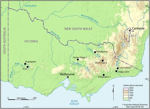
Figure 1. Map showing location of rockshelter and cave sites in elevated regions of Victoria mentioned in text.
Taungurung Country and cultural context
Taungurung Country is located in temperate central Victoria. It takes in the middle and upper parts of the Goulburn River catchment, including the mountainous headwaters region on the north side of the Great Dividing Range. Indeed, the ‘Goulburn tribe’ was the popular label for some of the Taungurung clans by nineteenth-century colonists (Barwick Citation1984:124). TLaWC is ‘the corporate representative “face” of the Taungurung people and serves to uphold their interests with respect to culture and country’ (TLaWC Citation2020). It is also the Registered Aboriginal Party (RAP) for Taungurung cultural heritage under the Aboriginal Heritage Act 2006 (Vic).
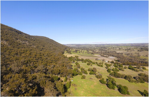
The north-south trending Seven Creeks valley, where Garden Range 2 is located, is flanked to the east by the western side of the north-south oriented Garden Range (). Garden Range 2 is elevated approximately 300 m asl while the nearby Seven Creeks is approximately 200 m asl. The highest point of Garden Range, located 1.3 km southeast of the site, is 679 m asl. Mt Strathbogie, the highest point on the Strathbogie Ranges plateau at 1033 m asl, is located 28 km southeast of Garden Range 2. Garden Range is part of the more extensive Strathbogie Ranges and is classified as a ‘mountains landform’ (LCC Citation1984:Map 7). Mountainous landforms are defined as >300 m relative local relief by McDonald et al. (Citation1990:36) and Rowan et al. (Citation2000:11).
Seven Creeks is a c.100-km-long waterway named after its seven headwater creeks in the Strathbogie Ranges (Cadwallader Citation1979; Wilson Citation1985:48). The creek flows southwest through the Strathbogie Ranges before turning north at Gooram Falls to run past Garden Range 2 and then northwest to exit the valley at Euroa where it continues northwest across riverine plains for a further 45 km to enter the Goulburn River at Shepparton which in turn enters the Murray River near Echuca a further 60 km to the northwest. Although Seven Creeks upstream of Euroa is fed by ‘permanent’ tributaries, it ‘ceased to flow’ downstream of Euroa during droughts in the summers of 1915 and 1968 (Cadwallader Citation1979:363; Halsall Citation1980:43, 94; Morgan Citation2018). The Seven Creeks valley has an annual average rainfall of 900–1200 mm with highest monthly rainfall occurring in winter (June, July, August) (Cadwallader Citation1979:363; Wood and McKinnon Citation1984). The highest average daily maximum temperature is 29 °C and this usually occurs in February, while the lowest average daily minimum temperature of 8 °C occurs in July (Wood and McKinnon Citation1984). Elevated parts of Garden Range and the wider Strathbogie Ranges ‘regularly’ receive ‘light snowfalls’ in winter (Wood and McKinnon Citation1984:7). Indeed, ‘snowfalls are quite frequent at 900 m during winter … on the Strathbogie Ranges’ (Ruddle Citation1977:8).
In the nineteenth century, during colonial invasion, pastoralists cleared the open forest in the lower parts of the Seven Creeks valley for grazing. Methods used included felling, ringbarking, and fire (Cadwallader Citation1979:363; Gubbins Citation2010:31; Halsall Citation1978:14). Early pastoralists recall ‘hoards [sic] of kangaroos and wallabies, also wombats, koala bears, tiger cats, etc., that inhabited the dense scrub and trees of the forest’ (Halsall Citation1978:97). Grasslands created and maintained by Aboriginal cultural burning practices attracted the attention of British pastoralists, who subsequently used these places for sheep farming (Chambers Citation1985:37). The study area forms part of the large Seven Creeks sheep run established by Scotsman and squatter John Templeton in 1838 (Chambers Citation1985:39; Grigg Citation2017:57; Templeton 1853). At the time, the Taungurung were recovering from the c.1830 smallpox epidemic (Clark Citation2013:19). The Seven Creeks station passed into the hands of Charles Barnes and Phillip Holland in 1843 and William Forlonge in 1851 (Chambers Citation1985:90; Grigg Citation2017:65, 82; Spreadborough and Anderson Citation1983:68; Wilson Citation1985). In 1846, John Dunmore Lang (Citation1847:287) visited the ‘Squatting Station of Mr. Holland’, noting a ‘fine valley’ and ‘plenty of land in the neighbourhood for cultivation’. In 1853, William Howitt (Citation1855, I:138, 283, 285) visited Forlonge’s station and new homestead (located 2 km southwest of Garden Range 2) and noted that the Aboriginal name for ‘Seven Creeks’ (run and/or creek?) was Gurra-gurra-gong (see also Grigg Citation2017:94–95, 110; Wilde Citation1994:30–31). Garden Range obtained its name in reference to an ‘orchard’ established next to Seven Creeks by Eliza Forlonge (mother of William) in the 1850s (Anonymous Citation1934:7).
Templeton (1853:229) claimed that Aboriginal people ‘very seldom appeared at my station, and then only in small numbers’. He further claimed that ‘I am glad to say that I never had any collision with them, nor in fact suffered any serious annoyance from them’ (Templeton Citation1853:229). In more populated parts of Taungurung Country closer to major waterways such as the Goulburn River, historical documents reveal a campaign of ‘extermination’ by certain pastoralists in the late 1830s and early 1840s (Barwick Citation1984:124; Chambers Citation1985:30; Kenny Citation2018). In response, the Taungurung waged a planned war of resistance in the form of strategic and targeted attacks on shepherds, pastoral workers, and sheep, cattle, and horse stocks (Christie Citation1979:63, 65–66; Clark Citation2013:91–94; Kenny Citation2018). When George Augustus Robinson, Chief Protector of the Port Phillip Aboriginal Protectorate, visited Templeton’s Seven Creeks station on 6 November 1842, he observed, hanging over the fireplace, an ‘obscene’ ink drawing of an Aboriginal man ‘hanging from a tree’ with the inscription ‘A warning to sheep stealers’ (Clark Citation2013:94, Citation2014:478). Where safe, some Taungurung gained employment on squatting runs in the region (Clark Citation2013:3, 95). With the establishment of the Protectorate in 1839, some Taungurung occasionally obtained refuge, work, provisions, and medical treatment at the Goulburn River District’s Central Station at Mitchellstown (1839–1840) and Murchison (1840–1853) (Clark Citation2013). As run/station work and hunting and gathering options dried up, many Taungurung gravitated to the Protectorate Reserves of Acheron (1859–1860), Mohican (1860–1863), and Coranderrk (1863–1950s) (Patterson and Jones Citation2020; Jones Citation2021; Kenny Citation2018; see also Caldere and Goff Citation1991; Christie Citation1979:96, 158–160, 167; Clark Citation2013:104).
Garden Range has mostly escaped the clear-felling and grazing pressures exerted by European pastoralists during the pastoral invasion. It supports open eucalypt forest (e.g. messmate stringybark, peppermint, box) with a light understorey of grasses and bracken fern (Wood and McKinnon Citation1984). Much of the range is crown land contained within the Mount Wombat-Garden Range Flora and Fauna Reserve. The block of land containing Garden Range 2 is similarly intact but freehold and now owned by TLaWC.
Little archaeological research and cultural site mapping has been undertaken along the c.10 km-long section of Seven Creeks valley adjacent to Garden Range. The best-known sites in the area are Garden Range Sites 1 to 4, a complex of granodiorite rockshelter rock art sites located within a few hundred metres of each other on the western face of Garden Range (Gunn Citation1981:263–272, Citation1983, Citation1984; Gunn and Thorn Citation2002). Europeans first reported these rock art sites in the late twentieth century (Halsall Citation1978:66). Garden Range 1 contains the largest assemblage of paintings of the site complex. A ‘test pit’ excavated at Garden Range 1 by Peter Coutts (Victoria Archaeological Survey) in 1974 ‘failed to reveal any occupational evidence’ (Gunn Citation1983:9, 12). Recording of rock art at Garden Range 2 in 1981 also included observation of quartz flakes, igneous flakes, burnt bone, and possibly burnt mussel shell on the surface of the rockshelter (Gunn Citation1981:270).
Since its registration in 2009, TLaWC has activated the inherent and unceded sovereign rights and obligations to Country of the Taungurung people, and in doing so asserted the right to control the recording, management, protection, expression, and research of their tangible and intangible cultural heritage sites and places. An important part of this cultural assertion is official representation on the First Peoples’ Assembly of Victoria that is spearheading formalisation of a Treaty between First Nations peoples and the State Government of Victoria. It is in this context that MISC and TLaWC entered into an archaeological research partnership, kicking off with TLaWC hosting MISC’s 2018 archaeology summer school undergraduate unit. TLaWC indicated a desire to increase understanding of the use and cultural significance of the Garden Range rock art sites, focusing on archaeological excavations of Garden Range 2 and 3. A team of archaeologists and archaeology students from Monash University and representatives of the Taungurung Aboriginal community excavated the sites in February and March 2018.
Garden Range 2
Garden Range 2 (VAHR 8024-0006) is located in the central northern part of the Taungurung RAP area approximately 10 km southeast of the rural township of Euroa and 120 km northeast of Melbourne. The rockshelter site is located on the eastern side of the Seven Creeks valley at the foot of the steep slope of Garden Range (). It centres on a free-standing boulder (tor) of Strathbogie Granodiorite, which forms part of the Garden Range component of the extensive Strathbogie granitic batholith of the Strathbogie Ranges (Phillips and Clemens Citation2013:38; VandenBerg Citation1997a). Local sediments are granodiorite derived with a high coarse-grained sand content. The surrounding vegetation is eucalypt forest with a grassy understorey. Approximately 50 m west of the site are open grassy pastures used for sheep grazing. The land slopes down to Seven Creeks, located a further 750 m to the west.
Figure 2. General view of Seven Creeks valley looking south, 21 June 2018. Garden Range 2 is located at the base of the tree line to the left of the white vehicle (photograph by Steve Micklethwaite).
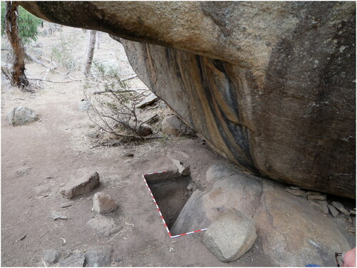
Garden Range 2 rockshelter is located at the northern end of the boulder (). The lower part of the northern end of the boulder has broken away along horizontal and vertical joints to create a void with an overhang. The back wall of the void (rockshelter) is a large flat surface oriented near vertically. This flat surface has a series of heavily weathered red ochre paintings (Gunn Citation1981:269–272; Gunn and Thorn Citation2002). Low tapering voids extend under the boulder at the base of the rear wall of the rockshelter and the exposed northwest side of the boulder. People have used a series of tabular fragments of exfoliated granodiorite to block-off the entrances to these voids, probably to deter foxes from using the alcove as a den (Gunn and Thorn Citation2002:26) (). The low void on the northwest side of the boulder features recent disturbance of surface sediments and scattered rabbit bones with soft tissue consistent with an active fox den.
Figure 3. Garden Range 2, after backfilling of Squares A and B, looking south, 20 June 2018 (photograph by Ian J. McNiven).
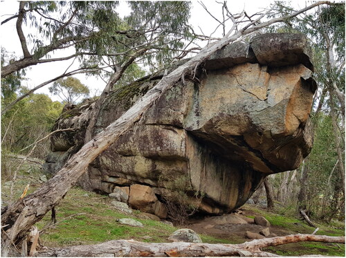
Figure 4. Garden Range 2 site map (artwork by Ian J. McNiven).
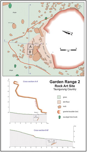
Figure 5. Garden Range 2 after excavation, looking east, 18 March 2018. Tabular fragments of granodiorite partly block the entrance to an active fox den on the lower right. Scales in 10 cm units (photograph by Ian J. McNiven).
The flat and sheltered area of the rockshelter covers approximately 25 m2. Relatively flat ground beyond the dripline to the north and west extends the potential useable area of the site. Vertical water flow stains (associated with the deposition of surface salts) at various points along the 5-m-wide rock art panel indicate that the rear surfaces of the rockshelter experience rainfall runoff. During excavation it was observed that surface rainfall runoff also enters the eastern side of the otherwise dry and protected area within the main dripline (see below).
Excavation aims and process
The aim of the excavation was to understand long-term Aboriginal use of the site, including chronological insights into the antiquity of rock art. Two contiguous 1 m × 1 m squares (Squares A and B) forming a 1 m × 2 m trench were carefully positioned beneath the highest concentration of rock art motifs to maximise potential recovery of ochres associated with creation of the paintings and any subsurface exfoliated wall fragments with art (). Systematic excavation proceeded using thin Excavation Units (XUs) removed with small trowels, brushes, and pans. Thin XUs allowed for documentation of potential post-depositional disturbance of sediments through fine-grained charting of the vertical distribution and potential vertical movement of cultural materials.
Square A was excavated to a mean depth of 119.3 cm using 54 XUs (170 when sub-XUs are counted) averaging 2.2 cm in thickness. Square B was excavated to a mean depth of 103.4 cm using 48 XUs (113 when sub-XUs are counted) similarly averaging 2.2 cm in thickness (Supplementary Materials: Figure A1). Excavation of Square A was ceased due to an absence of cultural objects observed during excavation. Excavation of Square B ceased due to the presence of granodiorite bedrock across the base of the square.
Stratigraphic Units (SUs) were differentiated during excavation based on differences in sediment colour, texture, compaction, and consolidation. Formal designation of SUs occurred during the process of drawing sections at the end of excavation. The number of XUs per SU ranged from four (SU2d) to 25 (SU8b) with variations in the number of XUs largely dependent on the thickness of the SU (Supplementary Materials: Figure A1). XUs were divided into sub-XUs (parts ‘a’, ‘b’, etc) to differentiate perceived differences in sediment. In some cases, sub-XUs indicate the start of a new SU. Attempts to align XU and SU boundaries were only moderately successful as SU transitions were often difficult to discern during excavation (Supplementary Materials: Figure A1).
Charcoal fragments suitable for radiocarbon dating were 3D-plotted and placed in separate plastic bags with a unique identifier label. All bones, shells, and stone artefacts larger than 2 cm or considered to be fragile were also 3D-plotted and bagged. The dip of each 3D find was also recorded (i.e. horizontal, vertical, inclined) as an indication of possible post-depositional disturbance. An A4 pro forma recorded details of each XU, including drawings of rocks and sediment changes across each XU. Rocks (≥10 cm in length) and major roots were plotted but not included in XU deposits for sieving. The elevations recorded at the end of XUs (corners and middle but often more) were tied to a temporary site datum (Datum 1 – high point on a nearby boulder) and measured to the nearest mm using an automatic level and stadia rod or tape measure. Datum 2 (high point of surface rock where it intersects the east side of Square A – see ) is elevated 257 mm below Datum 1. A detailed digital photographic record was made of every XU.
The weight of excavated deposit for each XU/sub-XU was measured to the nearest 0.1 kg using a spring balance. The volume of excavated deposit for each XU/sub-XU was recorded to the nearest 0.5 litres for volumes above 1.0 litre and to the nearest 0.05 litres for volumes less than 1.0 litre. Sediments were dry sieved through 2.1 mm mesh onto a plastic tarp located 20 m NNE of Square A. For each XU/sub-XU, a 50–100 g sample of sediment that passed through the sieve was collected for laboratory sediment analyses. The sieved fraction was placed into separate plastic bags. Excavations removed 1023.5 litres of deposit weighing 1559.1 kg, of which the vast majority (>70%) came from Square A (724.9 litres, 1121.2 kg) compared to Square B (298.6 litres, 437.9 kg).
After completion of excavation, section walls were cleaned using small brushes and trowels to facilitate delineation of features and SUs prior to comprehensive digital photography and detailed scale section drawings on graph paper. Bulk sediment samples (∼80 g) for each SU (including sub-SUs) were removed from the sections (mostly from the east section of Square A). In addition, 37 ∼ 80 g samples of sediment (Column Samples [CS]) were removed with a small trowel from the east section of Square A along a vertical transect at 2–5 cm depth intervals and placed into plastic bags for laboratory pollen analysis. The excavation trench was backfilled with sieve sediments and XU rocks (≥10 cm in length) from the excavations augmented by rocks and sediment obtained from more than 30 m north of the rockshelter. Green plastic shade cloth lined the walls and base of the trench prior to backfilling.
Sediments and stratigraphy
The deposit comprises eight major SUs (; Supplementary Materials: ). The primary source of the granitic sediments is from the adjacent hill slope. These sediments entered the rockshelter through the actions of wind and rainwater runoff. Sediments also include granular and block exfoliation of the granodiorite rockshelter, especially through roof fall.
Figure 6. East section, Square A, Garden Range 2, 11 March 2018. Horizontal scale in 10 cm units (photograph by Ian J. McNiven).
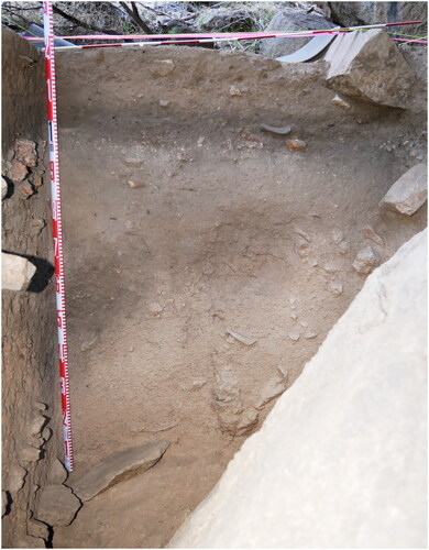
Figure 7. North and east sections, Squares A and B, Garden Range 2, 11 March 2018. Horizontal scales in 10 cm units (photograph by Ian J. McNiven).
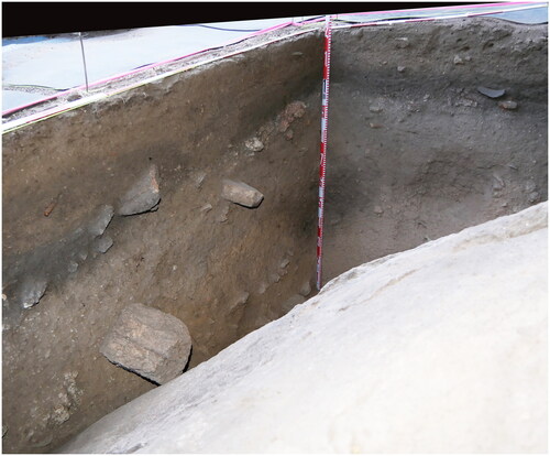
Figure 8. Section drawings, Squares A and B, Garden Range 2. Back-plotted radiocarbon ages (median) in red for Square A (artwork by Jeremy Ash and Ian J. McNiven).
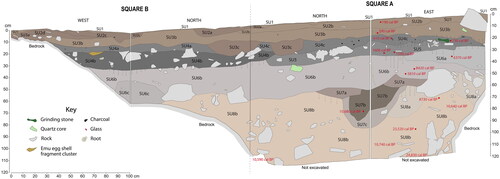
Table 1. AMS radiocarbon dates for Square A, Garden Range 2. Calibrated ages are rounded to the nearest 10 years.
Sediment colours and pH values were determined using the bulk SU sediment samples after air-drying. Dry sediment colour descriptions under natural light follow Munsell Soil-Color Charts (Munsell Citation2009). The determinations of sediment pH values follow methods outlined in Rayment and Lyons (Citation2011): the SU sediment samples (5.0 g) were mixed with 25 ml of deionised water and allowed to stand for 15 minutes after one hour of mechanical shaking. A TPS WP-80 pH/EC meter calibrated against 4.0, 7.0, and 10.0 pH buffers was used to measure pH values. The resulting pH values are the mean of two tests.
Summary sediment descriptions:
SU1 is dark greyish brown, loose, sandy sediment from the surface to 6 cm depth. pH = 5.8.
SU2 is very dark greyish brown, compact, coarse-grained sediment up to 9 cm below the surface, containing Aboriginal cultural materials (e.g. bone, shell, stone artefacts) and objects of European origin (glass, metal). Numerous rootlets. pH = 4.8–6.3.
SU3 is very dark greyish brown, mostly compact, coarse-grained sediment down to a depth of 23 cm. It contains cultural objects of European and Aboriginal origin. Numerous rootlets. pH = 5.5–7.8.
SU4 is very dark grey to black, compact, coarse-grained sediment with Aboriginal cultural materials extending to a depth of 33 cm. Scattered rootlets and roots. pH = 8.0–8.7.
SU5 is dark greyish brown, compact, coarse-grained sediment (Square A only) extending down to 36 cm below the surface with Aboriginal cultural materials. Scattered rootlets. pH = 9.0.
SU6 is dark greyish brown, compact, coarse-grained sediment with Aboriginal cultural materials between 26 and 63 cm below the surface and resting on granodiorite bedrock in Square B. Occasional roots, some large. pH = 7.4–9.0.
SU7 is a dark greyish brown to brown, compact, coarse-grained sediment. It is a U-shaped, pit-like feature in the northeast corner of Square A, containing a few stone artefacts, and it extends into the lighter-coloured sediments of SU8 over a depth range of 47–91 cm below the surface. It is interpreted as an infilled palaeo-channel associated with rainfall runoff in the past. Rootlets rare. pH = 8.1–9.2.
SU8 is pinkish grey, compact, coarse-grained sediment encompassing the lower half of the deposit between 47 and 120 cm below the surface. It contains a low number of tiny stone artefacts and is accumulated against steeply sloping ‘bedrock’ with sediments continuing below the base of the excavated pit in Square A. Occasional rootlets. pH = 7.5–9.0.
Whereas pH values for SUs 1 to 3b are acidic (4.8–6.3), pH values for SUs 3c to 8b are neutral to alkaline (7.4–9.2).
Radiocarbon dating and chronology
The chronology of the deposit was determined through radiocarbon dating of charcoal, which was found consistently throughout the deposit, in contrast to the more sporadic presence of bone and shell. In opting to date only charcoal samples and excluding shell and bone, we were prioritising uniformity in our dating method. Additionally, dating freshwater mussel shells could have introduced unaccounted-for reservoir effects from the absorption of old carbonates (e.g. Fernandes et al. Citation2012), and the bone assemblage was mostly burnt, making it unsuitable for radiocarbon dating due to potential contamination, degradation, and carbon-exchange issues (e.g. Herrando-Pérez Citation2021; Wolska Citation2020). OSL samples were not taken as sample removal would have severely damaged the sections and compromised the integrity of deposits in adjoining squares for excavation.
Eighteen AMS radiocarbon determinations (each using a single fragment of burnt wood charcoal) were obtained for Square A from the University of Waikato Radiocarbon Dating Laboratory (). Ten dated samples were in-situ 3D-finds, one was removed in-situ from the east section of Square A, one was found in the small sediment sample removed from the east section of Square A for pollen analysis, and the remaining six samples were recovered from the sieve. Calibrations were calculated using CALIB 8.2 (Stuiver et al. Citation2020) and the Southern Hemisphere calibration dataset (SHCal20) (Hogg et al. Citation2020). Following a request by TLaWC, calibrated ages are also expressed as ‘number of generations’ to aid comprehension of the historical time depth of the site. For this purpose, we use 28 years as the average ‘human generation interval’ (Fenner Citation2005:421; see also Bradshaw et al. Citation2019). Processing of samples for AMS dating included physical cleaning and chemical pre-treatment with samples washed in hot HCl, rinsed, and treated with multiple hot NaOH washes. The NaOH insoluble fraction was treated with hot HCl, filtered, rinsed, and dried. All calibrated ages report the 95.4% probability distribution. Median calibrated ages have heuristic value, albeit with statistical uncertainty. For the purposes of discussion of chronological periodisation, phasing, and trends, median calibrated ages have been rounded to the nearest 100 years and should be read as ‘circa’.
Radiocarbon ages reveal four separate and discontinuous chronological periods at Garden Range 2 over the past 25,000 years, with Holocene subepochs following Walker et al. (Citation2019):
Late Holocene (SUs 1–5) 200–1600 cal BP (∼7–57 generations ago),
Mid-Holocene (SU6) 5800–6400 cal BP (∼207–229 generations ago),
Early Holocene (SUs 6, 7, and 8) 8400–10,700 cal BP (∼300–382 generations ago), and
Late Pleistocene (SU8) 23,500–24,800 cal BP (∼839–886 generations ago).
All dating used detrital charcoal fragments as no hearth features were identified. Most dated charcoal fragments of Early to Late Holocene age were associated with relatively high concentrations of cultural objects and are considered to be associated with hearths and therefore cultural in origin (see Williams Citation2012:579–580). The absence of hearth features in Squares A and B is considered a result of either erasure from post-depositional (taphonomic) processes, both anthropogenic (e.g. trampling – Goldberg et al. Citation2017:S177; Miller et al. Citation2010:31) and biogenic (e.g. rootlet penetration – Mallol et al. Citation2007; insect burrowing – see below), or their location elsewhere within the rockshelter.
Charcoal fragments producing the two Late Pleistocene dates were associated with low quantities of stone artefacts and are of possible cultural origin. This cultural possibility is supported by the view that if Late Pleistocene charcoal fragments were entering the site by wind or water from natural landscape fires then such natural processes would be semi-regular occurrences and not limited to 23,000–25,000 years ago and absent throughout the entire Terminal Pleistocene between 12,000 and 18,000 years ago.
Late Holocene (SUs 1–5) 200–1600 cal BP
SUs 1–5 include the upper c.35 cm of deposit and the bulk of cultural materials recovered from the site. SUs 2 and 3 produced two median ages of 190 and 390 cal BP and coincide with the depth of materials of European origin (glass, metal, ungulate teeth, and rabbit bones/teeth – see below). The age of 390 cal BP may coincide with European arrival nearly 200 years ago if the potential ‘old-wood effect’ on dating is considered (see Schiffer Citation1986). SU4 produced two median ages of 610 and 730 cal BP, and SU5 produced two near-identical median ages of 1590 and 1600 cal BP.
Mid-Holocene (SU6) 5800–6400 cal BP
SU6 represents Mid-Holocene sediments with two median ages of 5810 and 6370 cal BP. Early Holocene and Late Pleistocene sediments are contained mostly within SUs 7 and 8.
Early Holocene (SUs 6, 7, 8) 8400–10,700 cal BP
The six determinations from this period (8420, 8730, 10,590, 10,640, 10,680, 10,740 cal BP) are spread across SUs 6, 7, and 8 between 46 and 115 cm below the surface. The single median age of 10,680 cal BP is available for the SU7 pit feature interpreted as a drainage channel. As such, this feature is broadly synchronous with adjacent Early Holocene sediments and wetter climatic conditions following the end of the Ice Age (see below).
Late Pleistocene (SU8) 23,500–24,800 cal BP
The two Late Pleistocene ages (23,520 and 24,830 cal BP) occur in the lower half of SU8 in basal sediments between 94 and 119 cm below the surface.
SU8b sediments in Square A also yielded two anomalous dates of nearly identical age: XU47b (2870 cal BP) and XU49f (2940 cal BP) at a depth of 98–105 cm below the surface. These Late Holocene dates occur within lower sediments and are considered stratigraphically intrusive from upper sediments. One possible explanation is that each of the single charcoal fragments that produced the anomalous dates fell in from the sections during excavation as the two samples were obtained from the sieve and not collected in situ as for most other dated charcoal fragments.
It is difficult to separate each of the four chronological periods into specific XUs for analytical purposes due to dating inversions and stratigraphic mixing of sediments (due to bioturbation). Such inversions are not uncommon where dating is undertaken using detrital charcoal and not charcoal sampled from ‘discrete charcoal lenses or hearths’ (Wood et al. Citation2016:15). As a result, it is impossible to separate Late Pleistocene from Early Holocene deposits in the lower levels (basal 25 cm of Square A), and Mid-Holocene from Early Holocene deposits in middle levels. While human activity at the site during the Early Holocene (10,600–10,700 cal BP) is unambiguous, activity during the Late Pleistocene (23,500–24,800 cal BP) is ambiguous albeit possible. As such, our discussion of chronological changes in cultural materials employs four occupation phases for analytical purposes ():
Table 2. Weight and volume of materials for occupation phases, Square A, Garden Range 2.
Phase 1: Late Holocene 1 (100–700 cal BP),
Phase 2: Late Holocene 2 (>700–1600 cal BP),
Phase 3: Mid- to Early Holocene (5800–10,700 cal BP), and
Phase 4: Early Holocene to Late Pleistocene (10,600–10,700/23,500–24,800 cal BP).
Bioturbation and post-depositional disturbance
Square A sediments exhibit some bioturbation. Rootlets occur through most of the deposit, with highest densities in SUs 2–3 within 15 cm of the surface. In the lower sections of the deposit (XUs 29–54) between around 50 and 120 cm below the surface, rootlets were rare in SU7 but present against the large granodiorite boulder (‘bedrock’) taking in the southern part of the trench in SU8. Sediments immediately adjacent to the granodiorite bedrock were also relatively darker. Concentrated rootlets and darker sediments are features consistent with localised moisture. A low number of mostly horizontal-running large roots (1–4 cm diameter) were encountered within Mid-Holocene sediments located between 30 and 40 cm below the surface in SU6 ().
Bioturbation by small mammal activity was evidenced by scats and clumps of recent putrefying fur (without skin). A few pieces of putrefying animal fur in XUs 2 and 3 within 4 cm of the surface are probably the result of a fox kill. Insect activity was evidenced by a number of burrow voids, termite tunnel castings, and live termites, ants, and cocoons. Live insect activity was limited to burrowing wasps and spiders (XUs 1–4 down to a depth of 5 cm below the surface), ants (XUs 4–5 down to a depth of 7 cm below the surface), termites and termite burrows (XUs 11–13 down to 26 cm below the surface), and insect cocoons (XUs 3–10 down to 19 cm below the surface). In summary, all visible evidence of post-depositional disturbance by animals in Square A was restricted to within 26 cm of the surface within SUs 1–5 dating from 1600 cal BP. Such restriction reflects the depth of the recent biomantle (zone of bioturbation). Thus, deeper and older sediments probably experienced similar faunal turbation in the past when the ground surface level (and biomantle) was at a lower elevation (see Johnson Citation2002).
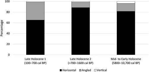
The dip orientation (or plunge orientation – see Bernatchez Citation2010) for 174 3D-plotted objects (e.g. stone artefacts, glass artefacts, charcoal, bones/teeth, shell) in Square A provides further insight into post-depositional disturbance. Objects were assigned to one of three dip orientation categories – horizontal (no disturbance), angled (minor to moderate disturbance), and vertical (major disturbance). These data are available for 3D-plotted objects collected in XUs 1–44, corresponding to SUs 1–7 and the upper half of SU8b (3D-plotable objects were absent from the lower half of SU8b). For the purposes of analysis, dip data was aggregated into occupation Phases 1–3: Late Holocene 1 (100–700 cal BP), XUs 1–11 (n = 86); Late Holocene 2 (>700–1600 cal BP), XUs 12–18 (n = 61); and Mid- to Early Holocene (5800–10,700 cal BP), XUs 15–44 (n = 27) (). The dip data indicate minimal to nil post-depositional disturbance. Nearly all objects (98%) were either horizontal (n = 132, 76%) or angled (n = 39, 22%). Only three objects were oriented vertically (i.e. reflecting major disturbance). The proportion of disturbed objects (angled and vertical) was highest in XUs 1–11 within 22 cm of the surface dating to 100–700 cal BP, corresponding to the recorded depth of observed faunal turbation down to 26 cm below the surface.
Figure 9. Dip-orientation categories for 3D-plotted objects in Square A according to chronological phases.
Cultural materials
Excavated materials recovered from Square A were sorted and analysed in the archaeology laboratory of MISC. Sorting of Square B materials was not completed for this paper. The preliminary analysis identified a range of materials, including charcoal, faunal remains (bone, mollusc shell, emu eggshell), flaked and ground stone artefacts, and materials of European origin (glass, metal). Two fragments of land snail (0.02 g) were identified in Square A, XUs 12 and 13. A small piece of red ochre (0.06 g) was recovered from Square A in XU20c and dates to the Mid- to Early Holocene. It is unknown if the ochre relates to rock art at the site, thus limiting insights into the potential age of the paintings. In addition to culturally introduced materials, 342.3 kg of granodiorite fragments were recovered from Square A (excluding rocks ≥10 cm in maximum length) (identified as ‘rock’ in ). None of the large pieces of granodiorite formed part of obvious hearth features. It is probable that many small pieces of granodiorite are a result of weathering of the rockshelter roof and wall.
Charcoal
Most (92%) of the 616.5 g of charcoal recovered from Square A occurs in Late Holocene levels dating from 1600 cal BP, with 70% dating from 700 cal BP. Late Holocene sediments contain one to two orders of magnitude higher charcoal concentrations than older sediments (). This relative abundance is similarly matched by other cultural materials such as bones, shells, and stone artefacts (see below) and is associated with relatively more burning activity and hearth use within the rockshelter.
Bone
The total weight of bone from Square A is 449.8 g and consists of both complete and fragmented elements (NISP = 134). Most faunal remains occur in Late Holocene sediments, with the highest concentration (59% by weight) dating to >700–1600 cal BP (). The minute presence of bone (0.03 g) from Phase 4 (Early Holocene to Late Pleistocene) probably reflects minimal site use and not weathering, as quantities of other cultural materials such as charcoal and stone artefacts are similarly very low and the associated neutral pH value of 7.5 is conducive to bone preservation (see Nielsen-Marsh et al. Citation2007).
Small, medium, and large-sized mammals (including macropods) dominate the highly fragmented bone assemblage, while bird, snake, and fish bones are rare (). Most if not all of these remains are considered to be associated with Aboriginal meals (see below). The local grassland and forested valley is the probable source of native terrestrial vertebrates (LCC Citation1984:Appendix V), with the nearby Seven Creeks being the nearest source of fish (Cadwallader Citation1979).
Table 3. Bone (NISP) identifications, Square A, Garden Range 2 (NB. no identifiable bones were recovered from >10,700 cal BP sediments).
Ungulate (including sheep and pig) bones are present (NISP = 4) and restricted to XUs 1–9 within 16.5 cm of the surface. The earliest possible age for these bones is ∼180 years, the time when European pastoralists arrived in the district in 1838. In addition, numerous rabbit bones (NISP = 30) were similarly recovered from XUs 1–9. A near-complete rabbit mandible was recovered from XU4a at a depth of 4.8 cm. The mandible was lying horizontal and appeared to be in a primary depositional context. The rabbit bones have a maximum age of ∼130 years, given the arrival of rabbits to the district in 1890 following their introduction to Victoria in 1859 (Halsall Citation1978:30; Ingersoll Citation1964; McLeod & Saunders Citation2014). The ungulate and rabbit were probably introduced to the site by foxes given that sheep and rabbits are the two most common prey of foxes in rural Victoria (Davis et al. Citation2015) and that they have established dens under the granodiorite boulder and at other nearby granodiorite outcrops. Foxes have been present in the region since the 1890s (Abbott Citation2011:509–510). The incorporation of introduced taxa bones within the upper 17 cm of sediments in Square A suggests that these upper-level sediments have been disturbed by post-contact animal bioturbation.
Preliminary insights into the extent of thermal alteration of bone in Square A were made using the 134 NISP bones (). Results reveal that just over half (n = 72, 54%) are burnt, with most (97%) of the burnt bones either moderately burnt (black/grey colour change from carbonisation at 300–650° C) (n = 64) or severely burnt (white colour change from calcination at ≥700° C) (n = 6) (Aplin et al. Citation2016; McDowell Citation2023; Moody et al. Citation2022). Calcination occurs with direct and sustained contact with intensive heat in hearth fires, whereas carbonisation can also occur inadvertently when abutting a hearth (Asmussen Citation2009; McDowell Citation2023; Stiner et al. Citation1995). The high proportion of burnt native taxa NISP bones (n = 72, 72%) and an absence of burnt introduced taxa bones is consistent with a cultural origin for the former and a natural origin for the latter.
The proportion of burnt NISP bones in Phase 1, 100–700 cal BP (8%) is low compared to very high rates in Phase 2, >700–1600 cal BP (91%) and high rates in Phase 3, 5800–10,700 cal BP (72%). Reasons for these chronological differences in burning are varied, and may include the high proportion of naturally occurring (unburnt) introduced fauna in Phase 1 (see above), and preservational bias to burnt bone in Phases 2 and 3 (see Aplin et al. Citation2016). Hypotheses concerning the cultural versus natural origin of bones and chronological variations in burning will be tested further with subsequent taxonomic and taphonomic analyses of the bone assemblages of Squares A and B.
Emu eggshell
Emu (Dromaius novaehollandiae) eggshell (3.4 g) is restricted to Late Holocene levels, 99% dating from 1600 cal BP, and 34% dating from 700 cal BP. Emus are rare in the broader Euroa region (ALA Citation2020) in the present day and are unknown in the Seven Creeks catchment (Mackay Citation1993). However, they were recorded in the Upper Goulburn River in the 1840s (Cotton Citation1848). Prior to European arrival, Seven Creeks valley would have been a suitable habitat for emus and their ground nests during the winter nesting season.
Mussel shell
Essentially all (98%) of the 45.9 g of mollusc shell in Square A occurs in Late Holocene levels dating from 1600 cal BP, with 47% dating from 700 cal BP (). All mollusc shell appears to be freshwater mussel (Hyriidae). Freshwater mussels were common to waterways of southeastern Australia prior to European colonisation (Jones and Byrne Citation2014). Although Seven Creeks has no official recordings of freshwater mussels, Balonne Freshwater Mussel (Velesunio ambiguous) are known to occur 20 km to the west (ALA Citation2020).
Flaked stone artefacts
Following Hiscock’s (Citation1984, Citation1988) definitions of flaked stone artefact fracture types, and his analytical approach to stone artefact technology and manufacturing techniques, a technological analysis was conducted on 2167 (625.8 g) stone artefacts recovered from Square A. Most stone artefacts (79%) were deposited during the Late Holocene, with 46% dating from 700 cal BP (). Stone artefacts are small, averaging 0.29 g with a mean maximum length of 7.5 mm. Nearly all (97.3%) stone artefacts were manufactured from quartz, followed by non-granitic igneous (1.6%), hornfels (0.7%), chert (0.3%), and quartzite (0.1%) ( and ). The high proportion of quartz use throughout the sequence reflects local geology. Quartz veins abound in this granitic landscape, with the largest quartz crystals (>10 mm) ‘concentrated in the Highlands and western Seven Creeks plateaux’ (Phillips and Clemens Citation2013:46, 50). Sources of non-granitic igneous raw materials and hornfels occur within 10 km of the site (VandenBerg Citation1997a). Chert and quartzite are not available locally, the nearest known sources are located 30 and 80 km to the southwest, respectively (VandenBerg Citation1997a, Citation1997b).
Table 4. Flaked stone artefact raw materials, Square A, Garden Range 2.
Table 5. Numerical representation (and proportion) of raw materials by occupation phase, Square A, Garden Range 2.
Stone artefacts were manufactured using freehand (unipolar) percussion, with a few instances of bipolar percussion restricted to quartz. In terms of fracture type, most artefacts are unretouched unipolar flakes (88.9%), followed by flaked pieces (6.1%), bipolar flakes and cores (3.8%), retouched flakes (1.0%), and unipolar cores (0.2%) (). Despite the small mean size of flaked artefacts, use of large cores at the site is revealed by a large milky quartz core slab (170 × 96 × 66 mm, 1463.1 g) recovered from the north section of Square A in the upper levels of SU6b dating to 6400–8400 cal BP (). No formal implement types were identified in the flaked stone artefact assemblage, apart from axes (see below).
Table 6. Numerical representation (and proportion) of fracture types by raw material, Square A, Garden Range 2.
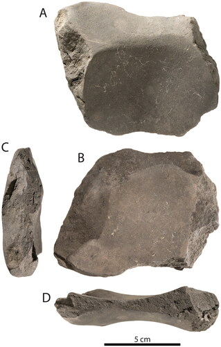
Axe flakes
Three of the 35 non-granitic igneous artefacts are volcanic flakes with areas of grinding (striations) on their dorsal surface. They were recovered from XUs 4c, 10a, and 11a (100–700 cal BP). These ground artefacts and the raw material type hint that these flakes derived from ground-edge axes as known ethnographically and archaeologically for Taungurung Country. Two of the artefacts are use-flakes (XU4c #2101; XU10a #309) and have features consistent with detachment from either the cutting edge or butt end of axes during use at the site ( and ) (for details see Supplementary Materials: Appendix C). The third artefact is a retouch-flake (XU11a, #498) detached from the cutting edge of a ground-edge axe during maintenance activities at the site to re-shape and re-sharpen a broken margin () (for details see Supplementary Materials: Appendix C).
Figure 10. 200–300-year-old use-flake from a ground-edge axe (Square A, XU4c, #2101). (A) Ventral surface (cf. compression-controlled crack propagation). Arrow shows the impact point. (B) Platform. Arrow shows the impact ridge. (C) Dorsal surface. (D) Detail of ground surface. Ellipses show the ground surface on the platform—probably part of the cutting edge of the stone axe. Scale bars are 5 mm (photographs by Richard Fullagar).
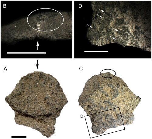
Figure 11. 600–700-year-old use-flake from a ground-edge axe (Square A, XU10a, #309). (A) Ventral surface. (B) Dorsal surface. (C) Platform. Arrow indicate impact ridge. Flake maximum dimension is 11 mm (photographs by Richard Fullagar).
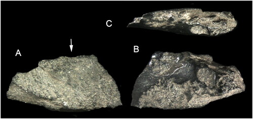
Figure 12. 700–800-year-old retouch-flake from a ground-edge axe (Square A, XU11a, #498). (A) Dorsal surface. Arrow shows the location of a hammer blow that detached a small flake before flake 498 was produced. (B) Detail of ground surface. Arrows show striations from grinding. (C) Ventral surface. (D) Proximal ventral. (E) Platform. (F) Longitudinal cross section. Black circles show indentation possibly from hammer impact. White dots show outline of bulbar scar. Scale is 5 mm (photographs by Richard Fullagar).
Grinding stone
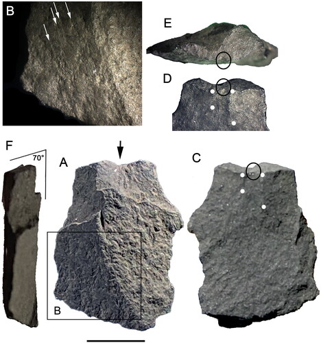
A grinding stone exposed in the east section of Square A during excavation of XU11a was removed after completion of section photographs and drawings (; Supplementary Materials: Figure A1). This utensil was lying sub-horizontal at a maximum depth of 22.0 cm below the surface within SU4c. A radiocarbon age of 680–770 cal BP (95.4%, Wk-47382) obtained for XU11a suggests strongly that the grinding stone was deposited around 700–800 years ago. Detailed investigation of the grinding stone (by RF and EH) indicates manufacture from fine-grained sandstone of dark green-brown colour, and four ground grooves: Grooves 1–3 are curved and about 1 cm deep, and Groove 4 is shallow and relatively flat (; Supplementary Materials: Appendix D). A wide range of sandstones outcrop across Taungurung Country (VandenBerg Citation1997a), suggesting that the grinding stone is of local manufacture. Indeed, White (Citation1954:26, 28) describes ‘fine-grained sandstones … which are green when fresh’ but ‘weather brown owing to the oxidation of iron to limonite’ outcropping 15 km south of Garden Range 2 (VandenBerg Citation1997a).
Figure 13. 700–800-year-old sandstone grinding stone (Square A). (A) Plan view of Grooves 2 and 3. (B) Plan view of Grooves 1 and 4. (C) End-on view of Margin A. (D) End-on view of Margin C (photographs by Steve Morton).
All four grooves of the grinding stone have signs of use oriented along their longitudinal axis, although some striations are oriented diagonally or at right angles across the groove. The margins of the grinding stone have been flaked, and some scars extend on to the surfaces of three grooves (Supplementary Materials: Figure D1). Grooves 2 and 4 dip down to intersect along Margin D. Grooves 1 and 3 also dip down to intersect along a thin margin (Margin C) representing an ancient break along which there is evidence of subsequent use in the form of distinct edge-rounding (or a ‘lip’).
The patterns of wear and breakage indicate that the grinding stone is a fragment of the central part of a larger, oval-shaped lower grinding stone that had grinding facets on either side, with flaked margins. The larger grinding stone broke near the middle, where grinding on both sides had worn down practically to the other side. The form of the original lower grinding stone, and remnants of use-polish on Groove 1, suggest that siliceous plant seed grinding and other starchy plant processing was the main function of this utensil. After this larger grinding stone broke, reshaping by marginal flaking repurposed the artefact into a small grinding stone. Residue analysis did not recover any starch grains from the used surfaces, indicating either a poor preservational environment or that subsequent use removed any evidence for processing of starchy plants (Supplementary Materials: Appendix D).
The dominance of very low polish with coarse striations on all grooves is consistent with stone-on-stone wear and recycling of a larger seed grinding stone into a portable whetstone for shaping and sharpening ground-edge axes. The most developed zones of polish, located on Groove 1, reveal plant tissue. The seed-grinding features may relate to use of the original larger, lower grinding stone, although they may also relate to incidental use of the (recycled) whetstone.
There are remnants of red translucent fragments and charcoal in residue extractions that are similar to resin from Xanthorrhoea (Supplementary Materials: Appendix D). Baylie (Citation1843:139) recorded that a ‘stone tomahawk … head is cemented by gum’ by Goulburn River basin Aboriginal people. This observation matches ethnographic records from various parts of Aboriginal Australia where Xanthorrhoea resin was mixed with charcoal as a hafting medium (Dickson Citation1981:164). Perhaps these traces indicate mixing the hafting medium on the grinding stone and/or the re-grinding and maintenance of stone axe heads that had broken or been removed from their haft. The Cosgrove, Howqua River, Mount William, and Mt Camel stone axe quarries located within 55–85 km to the north, southeast, southwest, and west, respectively, of Garden Range 2 (McBryde and Watchman Citation1976) indicate that Taungurung people had ready access to stone axes.
Glass
Eighteen glass objects (all colourless) were recovered from XUs 2–7 (0.8–11.5 cm below the surface) in SUs 1–3. XUs 2–5 (within 7.0 cm of the surface) contained all 13 3D-plotted glass objects lying horizontal. Fragments range in size (maximum length) from 5.0 mm to 52.6 mm. None of the fragments exhibits retouching or obvious use-wear (e.g. edge nibbling). Five fragments exhibit bidirectional flaking along snap-fracture margins consistent with treadage impact (see Loy and Wolski Citation1999:69). Seventeen pieces of glass are bottle body fragments ranging in maximum thickness (distance between inner and outer surfaces) from 1.3 to 7.7 mm. One glass fragment (Square A, XU4c, 3D Find #5) recovered from 5.6 cm below the surface exhibits a distinctively shaped ridge that matches the form of a raised collar below the screw top of a colourless bottle fragment collected from the surface approximately 1 m west of Square B. The large aperture of the screw top (internal diameter of 27 mm) and aluminium ring remains of the bottle cap are consistent with a large bottle, possibly a wine flagon.
None of the body fragments has features (e.g. embossed letters) indicative of manufacturer or age. However, most if not all fragments are probably twentieth century as they are colourless and essentially air bubble-free. Colourless bottle glass is relatively ‘uncommon’ prior to the 1870s and ‘quite common’ after the introduction of automatic bottle-making machines in the 1910s (Lindsey Citation2020; cf. Wilson and Cromwell Citation2012). The introduction of automatic bottle-making machines in the early 1900s also saw air bubbles becoming ‘relatively uncommon’ in bottle glass and ‘unusual’ after 1930 (Lindsey Citation2020). As such, the fragments of glass probably all date to the twentieth century and represent the activities of site visitors.
Metal
Square A contained 13 metal objects – one from XU5c (7.0 cm below the surface) and 12 from XU9 (14.2–16.4 cm below the surface) in SUs 2–4. The XU9 metal is splinters of rusty iron that appear to be the remains of a single nail. The only datable metal object is a .22 calibre bullet casing recovered from XU5c. It has a Super-X headstamp and rimfire indentation. The Super-X headstamp was introduced by Western Cartridge Company (est. 1898) of East Alton, Illinois, USA, in 1931, with production stopping around 1980 (Huegel Citation2014). As such, the casing dates to 1931–1980.
Pollen and palaeoenvironments
Pollen preserved in the sediments from a rockshelter site such as Garden Range 2 will primarily reflect vegetation growing in the surrounding landscape over time (see Moore et al. Citation1991). Thirty-seven column samples (CSs 1–37) for pollen analysis were collected from the eastern wall of Square A (Supplementary Materials: ). Only the top 13 samples (CSs 25–37) from SUs 1–5 (0.5–27.5 cm below the surface) contained pollen, with all deeper samples (CSs 1–24) from SUs 6–8 (30.5–117.0 cm below the surface) devoid of pollen. The recovered pollen is all Late Holocene in age, from 1600 cal BP through to the present. The preservation issues associated with the site are reflected in the concentration of recovered pollen, with the value for SUs 1–3 (∼24,000 grains/cm3 of sediment) significantly greater than that for SU4 (∼5000 grains) and SU5 (<2000 grains). The poor preservation below 27.5 cm no doubt reflects the open nature of the site and the tendency for the sediments to undergo periods of wetting and drying, conditions not ideal for pollen preservation.
SU5 – three samples (CSs 25–27) located 23.0–27.5 cm below the surface represent this unit and date to 1600 cal BP. Preservation is so poor in this unit that it is not possible to comment on the surrounding vegetation with any certainty. An unusual aspect of this assemblage is the dominance of Amaranthaceae pollen (a common edible family of plants), possibly due to preferential preservation of this small and robust pollen type.
SU4 – two samples (CSs 28 and 29) located 18.5 and 20.5 cm below the surface represent this unit and date to 600–700 cal BP. This unit has a high density of Aboriginal cultural material. These dark grey sediments are full of fine charcoal as well as a large concentration of plant silica (phytoliths) which have yet to be analysed. The pollen concentration is relatively low but significantly higher than SU5. Eucalyptus pollen, Poaceae (grass), Asteraceae (daisies), and a variety of fern spores dominate the assemblage. All are suggestive of a eucalypt forest with a herbaceous/fern understorey. While moss spores occur throughout the record, the lowest values are in SU4. Similar decreases in moss spores overlapping with intensive human occupation of rockshelter and cave sites have been found elsewhere (Head Citation1985).
SU3 – three samples (CSs 30–32) located 9.5–16.5 cm below the surface represent this unit. They date from 400–600 cal BP and encompass the 200-400 year lead up to European arrival. Like the samples below (SU4), they indicate eucalypt forest with a herbaceous and fern understorey. Values of Asteraceae (daisy) pollen are highest in these three samples, with the pollen type most similar to murnong (yam daisy – a staple food for Victorian Aboriginal people, see Gott Citation1983) also found throughout in low concentrations. There are also higher concentrations of moss spores in these samples, possibly indicative of less intense use of the rockshelter by people, in particular foot traffic across the floor surface and surrounding ground surface. The pollen signature matches early European observations of open eucalypt forests with either a mossy/fern or grassy understorey in the broader Strathbogie Ranges area (Gubbins Citation2010).
SUs 1–2 – five samples (CSs 33–37) from 7 cm to the surface represent these units. An associated radiocarbon age of 200 cal BP is consistent with the occurrence of Pinus pollen (introduced to the region by Europeans in 1847 – Gubbins Citation2010:64) and the colonial period. Although the changes in the assemblage are subtle, they record an initial decrease in Eucalyptus (possibly tree clearance), a decrease in fleshy herbs such as the daisies, alongside an increase in grass and bracken (a fern indicative of disturbance). Eucalyptus pollen increases in the uppermost samples, as does Acacia and Leptospermum pollen—both indicative of a woodier and thicker understorey, possibly associated with a cessation of Aboriginal cultural burning (see Fletcher et al. Citation2021; Mariani et al. Citation2022).
Discussion
Return of Garden Range 2 to Taungurung control
An important outcome of the 2018 excavations at Garden Range 2 was the formal and legal return of the site and the property back into the control of TLaWC in 2019. The 2018 property owners made the 23-ha parcel of land that contains Garden Range 2 available for purchase to TLaWC which occurred using funds from the Our Country Our Future grants program of the Australian Commonwealth government’s Indigenous Land and Sea Corporation (ILSC). The grant also funded construction of a vehicle track (with locked gate) to assist with access to the site by Elders and fencing to protect the property from damage by livestock. Matt Burns, CEO of TLaWC stated that ‘The acquisition of the Garden Range rock art site from the ILSC is of substantial cultural significance to the Taungurung people’. Furthermore, ‘The return of this land will enable us to care for Country using techniques passed down by our Ancestors, ensuring the location is preserved and protected for all Taungurung people—present and future—to see (Torre Citation2023; see also TLaWC Citation2023:13). This deep ancestral connection is materially expressed by the radiocarbon dating of excavated cultural materials to the past 11,000 years and possibly back to 25,000 years ago.
Late Pleistocene occupation during the Last Glacial Maximum?
Archaeological evidence for Aboriginal occupation of Victoria extends back 30,000–40,000 years (Hewitt and Allen Citation2010; Richards et al. Citation2007). In contrast, the oldest radiocarbon ages (median ages based on Calib 8.2 and SHCal20) for occupation of elevated (mountainous) regions of the state are more recent and within the period 20,000–30,000 years ago. In western Victoria, the oldest known site is Drual rockshelter (300 m asl) in the Victoria Range of Gariwerd (Grampians) at 26,300 cal BP (Bird and Frankel Citation2005:71). In eastern Victoria (Gippsland), the oldest known mountainous site is New Guinea II (110 m asl) at 25,100 cal BP (Ossa et al. Citation1995:28, 33), which matches the foothill sites of Wangangarra 1 (100 m asl) at 28,400 cal BP (Roberts et al. Citation2020) and Cloggs Cave (70 m asl) at 24,100 cal BP (Delannoy et al. Citation2020:24). Garden Range 2 (300 m asl) provides the first possible archaeological evidence for Aboriginal occupation of the margins of mountainous central Victoria during the Late Pleistocene at 24,800 cal BP. It remains unclear if the earliest available ages for Aboriginal occupation of mountainous and foothill regions of Victoria reflect slightly delayed occupation of these regions compared to lowland parts of the State or are simply a product of limited archaeological research (see Fresløv and Mullett Citation2023:878–879).
During the Late Pleistocene, environments of central Victoria were considerably different from those of the past 11,700 years (the Holocene). Pollen core data for upland regions of central and eastern Victoria indicate that following cooler and ‘treeless’ conditions prior to 36,000 years ago, temperatures slightly increased and woodlands expanded until around 31,000 years ago (McKenzie Citation1997:29, 33, Citation2002:49). Between at least 18,000 and 29,000 years ago, southeast mainland Australia experienced a long cold period known as the Last Glacial Maximum (LGM) where temperatures were up to 8 °C cooler than today at its peak around 21,000 years ago, and mountainous central and eastern Victoria generally returned to ‘treeless landscapes’ dominated by Asteraceae (herbs and shrubs) and Poaceae (grasses) (Cadd et al. Citation2021:6–7, 13–14; Kershaw et al. Citation2007:494; McKenzie Citation1997:19, 33; Williams et al. Citation2009:2398). Possible presence of people at Garden Range 2 at 24,800 cal BP coincides with the LGM. A LGM pulse of human occupation, albeit minor, is documented in Gippsland at Wangangarra 1 rockshelter between 26,100 and 28,400 cal BP (Roberts et al. Citation2020:185), New Guinea II at 25,100 cal BP (Ossa et al. Citation1995), and Cloggs Cave between 20,500 and 24,100 cal BP (Delannoy et al. Citation2020:24). The suitability of sites for occupation during the LGM undoubtedly reflected local factors (e.g. availability of food resources) and site-specific, micro-climatic factors (e.g. aspect and exposure to the sun and warmth). Elevation would have played an important factor in determining site use with areas above 1000 m asl exhibiting harsher and more extreme (colder and drier) climatic conditions during the LGM than lower elevation areas (McKenzie Citation1997).
Conditions for occupation of elevated regions of central and eastern Victoria improved a little during the final stages of the Ice Age (Terminal Pleistocene) between 12,000 and 18,000 years ago with a slightly warmer and wetter climate (but remaining cooler and drier than today) and ‘an overall increase in forest cover’ (McKenzie Citation2002:50). Yet archaeological evidence for cultural activity during this deglacial period is nil at Garden Range 2 in central Victoria and Gariwerd in western Victoria (Bird and Frankel Citation2005), and sparse for Gippsland in eastern Victoria (Mialanes et al. Citation2023; Ossa et al. Citation1995; Roberts et al. Citation2020) and upland sites in the ACT and adjacent areas of NSW (Fresløv and Mullett Citation2023:873; Theden-Ringl and Langley Citation2018:159). In this sense, foothill and adjacent mountainous regions of southeastern Australia fit a broader pattern of limited cultural remains (linked to population decline) seen in many parts of Australia during the Terminal Pleistocene (Williams Citation2013; Williams et al. Citation2023:527). For the Strathbogie Ranges of central Victoria, Terminal Pleistocene population decreases may have been relative as the Old People focused activities away from upland rockshelters to lowland open campsites located across the resource-rich riverine plains and waterways (including palaeo-lakes) of the Goulburn River catchment (see Ogden et al. Citation2001:207; Page et al. Citation2009:S24, S30; Pardoe Citation1995; Stone Citation2006). Although riverine open sites (e.g. stone artefact deposits, middens, and burials) dating to the Terminal Pleistocene have yet to be documented for the Goulburn River catchment, such sites occur immediately to the northwest at Kow Swamp (Stone and Cupper Citation2003; Thorne and Macumber Citation1972; Wright Citation1975) and further away on the Murray River in northwest Victoria at Ned’s Corner (Garvey Citation2017; Prendergast et al. Citation2009).
Mid- to Early Holocene occupation
The earliest unambiguous evidence for occupation of Garden Range 2 by the Old People occurs in the Mid- to Early Holocene between 5800 and 10,700 cal BP. Cloggs Cave and New Guinea II similarly reveal evidence of a human presence during the Mid- to Early Holocene (Delannoy et al. Citation2020; Ossa et al. Citation1995), while Wangangarra 1 exhibits Mid-Holocene activity around 5800 years ago (Roberts et al. Citation2020:185). The end of the last glacial (Terminal Pleistocene) and the transition to the Early Holocene in central and eastern Victoria was a time of rapid and major change in climate and vegetation (McKenzie Citation2002:49). Pollen sequences reveal Early Holocene increases in eucalypt forest, temperatures, and effective precipitation (Kershaw et al. Citation2007:494; McKenzie Citation1997:34, Citation2002:50). Climatic amelioration between 5000 and 9500 years ago led to the maximum Holocene extent of Eucalyptus and Nothofagus forest (‘forest optimum’) centring on 7000 years ago (McKenzie Citation1997:34, Citation2002:51). Occupation of Garden Range 2 in the Early Holocene coincides with the onset of favourable environmental conditions for resource (food and water) abundance following the end of the Ice Age. This coincidence indicates that such resource changes reached a socio-economic threshold for viable (re)occupation of Garden Range 2 by 11,000 years ago. We posit that (re)occupation indicated increased attractiveness of foothill and adjacent mountainous areas for local communities due to expansion of forests and a desire to harvest forest resources. Similar increases in use of ‘high country’ regions linked to warmer and wetter conditions of the Mid- to Early Holocene Climatic Optimum have been documented for the ACT and adjacent areas of NSW (Theden-Ringl and Langley Citation2018; Theden-Ringl et al. Citation2020).
Late Holocene occupation intensification
Square A at Garden Range 2 registers little or no evidence of occupation between 1600 and 5800 cal BP, after which intensive occupation occurs (Phases 1 and 2) through to the nineteenth century. The apparent hiatus in site use prior to Late Holocene occupation intensification may relate partly to the onset of ‘drier conditions’ 5000 years ago associated with an increase in temperature and/or decrease in effective precipitation (McKenzie Citation1997:34). The hiatus in occupation of Garden Range 2 supports the hypothesis that these drier conditions resulted in a major restructuring of land-use practices in response to decreases in the availability and reliability of water and food resources in the Seven Creeks catchment. Lakes in southwest Victoria indicate fluctuating water levels (and drier conditions) between 1200 and 4000 years ago before a major increase in water levels (and wetter conditions) over the past 1200 years (Wilkins et al. Citation2013:793). More variable and slightly drier conditions 2000–3500 years ago are associated with intensified El Niño–Southern Oscillation (ENSO) activity, with ENSO conditions modernising over the past 1500 years (Donders et al. Citation2007).
On the southern margins of the Great Dividing Range, Wangangarra 1 rockshelter exhibits an almost identical Late Holocene intensive period of occupation to Garden Range 2 (Phases 1 and 2) with most occupation occurring within the past 1500 years (Roberts et al. Citation2020:185). On the northern margins of the Great Dividing Range and located 120 km northeast of Garden Range 2, Mudgegonga rock art site (elevated 350 m asl) has most cultural materials dated to between 600 and 3700 years ago (Perham Citation1985). In the middle of the Great Dividing Range and located 150 km east of Garden Range 2, Mount Cope 6 rockshelter (elevation 1800 m asl), with a basal date of 6600 cal BP, reveals increased occupation from 1500 cal BP (Fresløv and Mullett Citation2023:877; Shawcross et al. Citation2006). These Victorian sites suggest a general association between wetter conditions and increased activity at elevated rockshelter sites within the past 1500 years. The adjacent sub-alpine (1400–1850 m asl) and alpine (>1850 m asl) zones of southeastern NSW and the ACT similarly reveal major increases in the deposition of stone artefacts within rockshelters during the past 1000–2000 years (Flood Citation1980; Flood et al. Citation1987; Rosenfeld et al. Citation1983; Theden-Ringl Citation2016). Theden-Ringl and Langley (Citation2018:160) note that such Late Holocene activity represented a ‘re-occupation of the region’ following ‘reduced’ occupation between 2000 and 4500 years ago linked to ENSO and ‘a more marginal environment for human habitation’ (see also Theden-Ringl et al. Citation2023:91).
Since the early 1980s, numerous archaeological studies have documented intensified occupation of all environmental zones of Victoria and other parts of southeastern Australia in the Late Holocene and particularly in the past 2000 years (Bird and Frankel Citation1991; Lourandos Citation1983, Citation1997; McNiven et al. Citation1999, Citation2015; see also Williams et al. Citation2015). We posit that increased resource opportunities in the Late Holocene helped facilitate, support, and structure intensified socio-cultural use of upland regions over the past 2000 years. Garden Range 2 alerts us to the fact that rock art sites located in upland (foothill and adjacent mountainous) regions, and associated ceremonial activities, may have been a critical expression of this intensified activity. To what extent nearby Garden Range 1, the largest known rock art site in central Victoria (Gunn Citation1983), was part of the hypothesised Late Holocene intensification at Garden Range 2 will require chronometric insights via excavation of associated occupation deposits. Fresløv and Mullett (Citation2023:881) make the broader point that ‘the High Country held special significance as a spiritual landscape, imbued with cosmological meaning and a focal location of ceremony and initiation rituals’.
The three ground-edge axe fragments at Garden Range 2 dating from 700 cal BP provide rare insights into the antiquity of stone axes in Victoria. Published references to dated ground-edge axes in Victoria all come from the western half of the state: Mugadgadjin rockshelter (<300 years) (Bird and Frankel Citation2005:97), McArthur Creek Mound 5 (<400 years) (Williams Citation1988:84, 108), Glen Aire II rockshelter (<500 years) (Mulvaney Citation1962:9–10), Seal Point midden (<1400 years) (Lourandos Citation1980:262, 266), and Dry Plain Mound 8 (<1400 years?) (Coutts Citation1982:10). The Garden Range 2 axe evidence from central Victoria supports the long-standing view that inter-regional exchange networks involving stone axes were an important dimension of the Late Holocene intensification process (Lourandos Citation1983:91, Citation1997:232). Future sourcing of these axe fragments will help test the inter-regional exchange hypothesis.
The 700–800-year-old grinding stone repurposed into a stone axe maintenance/resharpening implement recovered from Garden Range 2 is similar in form to portable grinding stones linked to axes (whetstones) found (albeit rarely) in archaeological surface scatter sites in the sub-alpine zone of Taungurung Country and other parts of mountainous southeastern Australia (see Flood Citation1980:200, Tables 13 and 14). For example, Mitchell (Citation1940:184, Pl. 16) documents a number of small ‘axe grinding and sharpening stones’ made from ‘slabs of sandstone’ at Mt Buffalo, while Fisch (Citation1953:151) describes a small ‘sharpening stone on which axe-heads were ground’ comprising a ‘slab of hard sedimentary rock with a well-worn groove’ at Mt Buller. More broadly, Smyth (Citation1878, I:384) mentions small portable ‘sharpening stones’ found ‘occasionally on or a little beneath the surface of the ground all over the colony’ of Victoria that ‘were used for polishing the edges of tomahawks’. During the late nineteenth century, Howitt (Citation1904:312) observed that stone axe use by the GunaiKurnai of Gippsland to the immediate southeast of Taungurung Country included ‘Pieces of grinding-stone … carried from camp to camp for the purpose of sharpening the edge when necessary’. It is in this context of cursory observations that use-wear and residue analyses of the portable axe grinding stone from Garden Range 2 provide the first archaeological confirmation of the veracity and antiquity of this implement type in Victoria.
Although somewhat limited by poor preservation, the pollen recovered from SUs 1–5 provides a record of landscape change for Garden Range 2 from 1600 cal BP. For most of this time, vegetation was relatively similar to the vegetation surrounding the site today, with the presence of fern and moss spores indicating that the area was wetter in the period preceding European arrival. Within the period of European pastoral invasion, fern and moss spores, Eucalyptus, Leptospermum, and Asteraceae (daisies) all decline in association with a corresponding increase in Poaceae (grass). The shift to grasslands possibly indicates an intensification of land clearing, with the greatest percentage of grass pollen recovered from the uppermost sample at a depth of 0.5 cm. The lack of ferns (besides bracken—a disturbance indicator) and mosses is consistent with a relatively drier environment seen across southern Australia over the past 150 years (Gergis et al. Citation2012; see also Adeleye et al. Citation2022).
Conclusion
Prior to excavations at Garden Range 2 located on the northern margins of the Great Dividing Range, Aboriginal sites with evidence of Early Holocene occupation in the elevated regions of central and eastern Victoria were known only for the southern margins of the Great Dividing Range in GunaiKurnai Country in Gippsland (Cloggs Cave, New Guinea II, Wangangarra 1). Further archaeological work in Taungurung Country will probably reveals unequivocal evidence for Late Pleistocene activity given archaeological evidence of Late Pleistocene occupation of the mountainous/foothill regions of nearby Gippsland. What remains unknown is the suitability of higher elevation (≥1400 m asl) sub-alpine and alpine (snow country) zones across central and eastern Victoria for occupation by the Old People during extreme climatic conditions of the Late Pleistocene, especially during the LGM between 18,000 and 29,000 years ago. Theden-Ringl and Langley (Citation2018:159) make the important observation that none of the 12 excavated archaeological sites located above 1000 m asl in the high country of southeastern NSW and the ACT reveals evidence of occupation >10,000 years ago (see also Aplin et al. Citation2010). In contrast, six sites located <1000 m asl in the same region reveal evidence of occupation during the Late Pleistocene. Fresløv and Mullett (Citation2023:879) add that there is ‘currently no archaeological evidence for the occupation of the alpine and subalpine zones [>1400 m asl] of southeastern Australia dating to before the Mid-Holocene’.
A critical need exists to determine whether the long-term history of Aboriginal use of the high country (>1000 m asl) of central and eastern Victoria is similar to or different from that known for adjacent regions of NSW and the ACT. Most research to date has been limited to the lower elevation (foothill) margins of, and valley corridor entries to, the mountainous high country of Victoria. Future archaeological excavations need to target upland sites to understand the occupational thresholds of Aboriginal peoples for sub-alpine and alpine Victoria over the past 30,000 years.
Supplemental Material
Download PDF (1.4 MB)Supplemental Material
Download PDF (443.3 KB)Acknowledgements
Excavation of Garden Range 2 occurred under Cultural Heritage Permit RES01/2018 issued by the Taungurung Clans Aboriginal Corporation pursuant to the Aboriginal Heritage Act 2006 (Vic). The following students from the Monash University’s summer school undergraduate unit—ATS3544 On a dig: Practical archaeology in the field—kindly assisted with the excavations: River Arumets-Smith, Rachael Benbow, Lucinda Bowra, Helen Batey-Smith, Deborah Connelly, Zoe Lay, Clay Law, Gideon Lewis, Nic Reilly, Rahel Teklu, and Rob Tobin. For fieldwork assistance, culinary support, and good humour we thank Michael Coulter. Bruno David, Daniel Derouet, Julian Dunn, Anna Garamszegi, Brigid Hill, Madeleine Kelly, Steven Micklethwaite, Darcy Mullaney, Holly Parker, and Chris Urwin also kindly assisted with fieldwork. Numerous people, including students, assisted with laboratory sorting of excavated materials: River Arumets-Smith, Shayne Bates-Gilby, Helen Batey-Smith, Rachael Benbow, Lucinda Bowra, Deb Connelly, Julian Dunn, Karen Finlay, Jaimi Houston, Bianca Jewell, Clay Law, Zoe Lay, Gideon Lewis, Nic Reilly, Rob Tobin, Joshua Webb, Yimeng Bu, and Bec Zeidan. Special thanks to Taungurung representatives Paul Harding, Shane Monk, and Peter Moser for cultural guidance and advice during the excavations. Francisco Almeida, Katherine Thomas, and Libby Riches, Cultural Heritage, TLaWC, generously provided helpful archaeological advice and support through various stages of this project. We thank Joanna Fresløv, GunaiKurnai Land and Waters Aboriginal Corporation, for advice on the archaeology of the Victorian High Country. At the time of excavation, Garden Range 2 was on land owned by Kate and Alan Dawes, whom we thank for allowing us access to their property, their generous support, assistance, advice, and hospitality. Monash Indigenous Studies Centre at Monash University provided institutional support to IM and JA. The University of New South Wales provided institutional support to JF. Thanks to Maille Todd and Vanessa Wong (School of Earth, Atmosphere and Environment, Monash University) for undertaking pH analysis of sediments. Many thanks to two anonymous reviewers for their careful reading of, and helpful comments on, an early draft of this paper.
Disclosure statement
No potential conflict of interest was reported by the author(s).
Additional information
Funding
References
- Abbott, I. 2011 The importation, release, establishment, spread, and early impact on prey animals of the red fox Vulpes vulpes in Victoria and adjoining parts of south-eastern Australia. Australian Zoologist 35(3):463–533.
- Adeleye, M.A., S.E. Connor, S.G. Haberle, A. Herbert and J. Brown 2022 European colonization and the emergence of novel fire regimes in southeast Australia. The Anthropocene Review 9(3):537–549.
- ALA 2020 Atlas of Living Australia. https://www.ala.org.au, accessed 24 October 2020.
- Anonymous 1934 Pioneer woman’s grave: Funds for memorial. Argus newspaper, 28 March, p.7.
- Aplin, K., F. Ford and P. Hiscock 2010 Early Holocene human occupation and environment of the southeast Australian Alps: New evidence from the Yarrangobilly Plateau, New South Wales. In S. Haberle, J. Stevenson and M. Prebble (eds), Altered Ecologies: Fire, Climate and Human Influence on Terrestrial Landscapes, pp.187–212. Terra Australis 32. Canberra: ANU E-Press.
- Aplin, K., T. Manne and V. Attenbrow 2016 Using a 3-stage burning categorization to assess post-depositional degradation of archaeofaunal assemblages: Some observations based on multiple prehistoric sites in Australasia. Journal of Archaeological Science: Reports 7:700–714.
- Asmussen, B. 2009 Intentional or incidental thermal modification? Analysing site occupation via burned bone. Journal of Archaeological Science 36(2):528–536.
- Baylie, W.H. 1843 On the Aborigines of the Goulburn District (Their superstitions, manners, and habits). The Port Phillip Magazine 1(2):86–92, 1(3):134–139, 1(4):188–191.
- Barwick, D.E. 1984 Mapping the past: An atlas of Victorian clans 1835–1904: Part 1. Aboriginal History Journal 8(1/2):100–131.
- Bernatchez, J.A. 2010 Taphonomic implications of orientation of plotted finds from Pinnacle Point 13B (Mossel Bay, Western Cape Province, South Africa). Journal of Human Evolution 59(3–4):274–288.
- Bird, C.F.M. and D. Frankel 1991 Chronology and explanation in western Victoria and south-east South Australia. Archaeology in Oceania 26(1):1–16.
- Bird, C.F.M. and D. Frankel 2005 An Archaeology of Gariwerd: From Pleistocene to Holocene in Western Victoria. Tempus 8. St Lucia: Anthropology Museum, The University of Queensland.
- Bradshaw, C.J.A., S. Ulm, A.N. Williams, M.I. Bird, … and F. Saltré 2019 Minimum founding populations for the first peopling of Sahul. Nature Ecology & Evolution 3(7):1057–1063.
- Cadd, H., L. Petherick, J. Tyler, A. Herbert, … and M.R.P. Harris 2021 A continental perspective on the timing of environmental change during the last glacial stage in Australia. Quaternary Research 102:5–23.
- Cadwallader, P.L. 1979 Distribution of native and introduced fish in the Seven Creeks River system, Victoria. Austral Ecology 4(4):361–385.
- Caldere, D.B. and D.J. Goff 1991 Aboriginal Reserves & Missions in Victoria. Melbourne: Department of Conservation & Environment.
- Chambers, D. 1985 Violet Town or Honeysuckle in Australia Felix 1836–1908. Carlton: Melbourne University Press.
- Christie, M.F. 1979 Aborigines in Colonial Victoria 1835–86. Sydney: Sydney University Press.
- Clark, I.D. 2013 Goulburn River Aboriginal Protectorate: A History of the Goulburn River Aboriginal Protectorate Station at Murchison Victoria 1840–1853. Ballarat: Ballarat Heritage Services.
- Clark, I.D. 2014 (ed.) The Journal of George Augustus Robinson, Chief Protector, Port Phillip Aboriginal Protectorate, 1839–1852. Scotts Valley, CA: CreateSpace Independent Publishing Platform.
- Cotton, J. 1848 A list of birds which frequent the upper portion of the River Goulburn, in the district of Port Phillip, New South Wales. The Tasmanian Journal of Natural Science 3(5):361–365.
- Coutts, P.J.F. 1982 Victoria Archaeological Survey activities report 1979–80. Records of the Victoria Archaeological Survey 13:1–27.
- Davis, N.E., D.M. Forsyth, B. Triggs, C. Pascoe, … and L.F. Lumsden 2015 Interspecific and geographic variation in the diets of sympatric carnivores: Dingoes/wild dogs and red foxes in south-eastern Australia. PLoS One 10(6):e0130241.
- Delannoy, J.-J., B. David, J. Fresløv, R. Mullett, … and GunaiKurnai Land and Waters Aboriginal Corporation 2020 Geomorphological context and formation history of Cloggs Cave: What was the cave like when people inhabited it? Journal of Archaeological Science: Reports 33:102461.
- Dickson, F.P. 1981 Australia Stone Hatchets: A Study in Design and Dynamics. Sydney: Academic Press.
- Donders, T.H., S.G. Haberle, G. Hope, F. Wagner and H. Visscher 2007 Pollen evidence for the transition of the eastern Australian climate system from the post-glacial to the present day ENSO mode. Quaternary Science Reviews 26(11-12):1621–1637.
- Fenner, J.N. 2005 Cross-cultural estimation of the human generation interval for use in genetics-based population divergence studies. American Journal of Physical Anthropology 128(2):415–423.
- Fernandes, R., S. Bergemann, S. Hartz, P.M. Grootes, … and M. Hüls 2012 Mussels with meat: Bivalve tissue-shell radiocarbon age differences and archaeological implications. Radiocarbon 54(3–4):953–965.
- Fisch, P. 1953 Visit to Mount Buller. The Victorian Naturalist 69:150–152.
- Fletcher, M.-S., A. Romano, S. Connor, M. Mariani and S.Y. Maezumi 2021 Catastrophic bushfires, Indigenous fire knowledge and reframing science in southeast Australia. Fire 4(3):61.
- Flood, J. 1980 The Moth Hunters: Aboriginal Prehistory of the Australian Alps. Canberra: Australian Institute of Aboriginal Studies.
- Flood, J. 1987 Moth hunters of the southeastern highlands. In D.J. Mulvaney and J.P. White (eds), Australians to 1788, pp.274–291. Broadway, NSW: Fairfax, Syme and Weldon Associates.
- Flood, J., B. David, J. Magee and B. English 1987 Birrigai: A Pleistocene site in the South-Eastern Highlands. Archaeology in Oceania 22(1):9–26.
- Frankel, D. 2017 Between the Murray and the Sea: Aboriginal Archaeology in Southeastern Australia. Sydney: Sydney University Press.
- Fresløv, J. and R. Mullett 2023 Below the sky, and above the clouds: The archaeology of the Australian High Country. In I.J. McNiven and B. David (eds), The Oxford Handbook of the Archaeology of Indigenous Australia and New Guinea, pp.861–888. Oxford: Oxford University Press.
- Gardner, P.D. 1992 Aboriginal history in the Victorian Alpine region. In B. Scougall (ed.), Cultural Heritage of the Australian Alps, pp.89–99. Canberra: Australian Alps Liaison Committee.
- Garvey, J. 2017 Australian Aboriginal freshwater shell middens from late Quaternary northwest Victoria: Prey choice, economic variability and exploitation. Quaternary International 427:85–102.
- Gergis, J., A.J.E. Gallant, K. Braganza, D.J. Karoly, … and S. McGregor 2012 On the long-term context of the 1997–2009 ‘Big Dry’ in South-Eastern Australia: Insights from a 206-year multi-proxy rainfall reconstruction. Climatic Change 111(3–4):923–944.
- Godfrey, M.C.S., C.F.M. Bird, D. Frankel, J.W. Rhoads and S. Simmons 1996 From time to time: Radiocarbon information on Victorian archaeological sites held by Aboriginal Affairs Victoria. The Artefact 19:3–51.
- Goldberg, P., C.E. Miller and S.M. Mentzer 2017 Recognizing fire in the Paleolithic archaeological record. Current Anthropology 58(S16):S175–S190.
- Gott, B. 1983 Murnong – Microseris scapigera: A study of a staple food of Victorian Aborigines. Australian Aboriginal Studies 2:2–18.
- Grigg, T. 2017 The Squatters and Graziers: The Seven Creeks Estate, Euroa. The Property and its People 1838–2017. Euroa: Terry Grigg.
- Gubbins, W. 2010 Vegetation Change and the Ecological Effects of European Settlement: A Palynological and Historical Investigation of the Strathbogie Ranges, Victoria. Unpublished Honours thesis, Department of Resource Management and Geography, The University of Melbourne.
- Gunn, R.G. 1981 The Prehistoric Rock Art Sites of Victoria: A Catalogue. Victoria Archaeological Survey Occasional Report Series Number 5. Melbourne: Ministry for Conservation.
- Gunn, R.G. 1983 Garden Range 1 Aboriginal Rock Art Site (Site 80243/005). Victoria Archaeological Survey Occasional Reports Series Number 18. Melbourne: Ministry for Planning and Environment.
- Gunn, R.G. 1984 The rock art areas of Victoria: An initial comparison. Aboriginal History Journal 8(1/2):189–202.
- Gunn, R.G. 1990 The Ngurai-illam-Wurrung Rock Well at Whroo (Site 7924/01). Victoria Archaeological Survey Occasional Report No. 32. Melbourne: Department of Conservation and Environment.
- Gunn, R.G., and A. Thorn 2002 Garden Range Aboriginal Rock Art Complex: Conservation and Management Assessment. AAV Site Nos 8024- 5, 6, 8 & 9. A report to Parks Victoria, Alexandria.
- Halsall, C. 1978 Strathbogie Centenary 1877–1977. A History of Strathbogie. Strathbogie: Strathbogie Centenary Committee.
- Halsall, C.W. 1980 100 Years of Local Government 1880–1980: A General History of Euroa and District. Euroa: Shire of Euroa.
- Head, L. 1985 Pollen analysis of sediments from the Bridgewater Caves archaeological site, southwestern Victoria. Australian Archaeology 20(1):1–15.
- Herrando-Pérez, S. 2021 Bone need not remain an elephant in the room for radiocarbon dating. Royal Society Open Science 8(1):201351.
- Hewitt, G. and J. Allen 2010 Site disturbance and archaeological integrity: The case of Bend Road, an open site in Melbourne spanning Pre-LGM Pleistocene to Late Holocene periods. Australian Archaeology 70(1):1–16.
- Hiscock, P. 1984 Preliminary report on the stone artefacts from Colless Creek Cave, northwest Queensland. Queensland Archaeological Research 1:120–151.
- Hiscock, P. 1988 Prehistoric Settlement Patterns and Artefact Manufacture at Lawn Hill, Northwest Queensland. Unpublished PhD thesis, Department of Anthropology and Sociology, University of Queensland.
- Hogg, A.G., T.J. Heaton, Q. Hua, J.G. Palmer, … and L. Wacker 2020 SHCal20 Southern Hemisphere calibration, 0–55,000 years cal BP. Radiocarbon 62(4):759–778.
- Howitt, A.W. 1904 The Native Tribes of South-East Australia. London: Macmillan & Co. Ltd.
- Howitt, W. 1855 Land, Labor and Gold: Or, Two Years in Victoria. Vols 1 & 2. Boston: Ticknor and Fields.
- Huegel, R.E. 2014 22 Rim Fire Boxes of the U.S.A. ID. Reference: Western Cartridges. Western Cartridge Company, East Alton, Illinois. http://citeseerx.ist.psu.edu/viewdoc/download?doi=10.1.1.692.6410&rep=rep1&type=pdf, accessed 24 October 2020.
- Ingersoll, J.M. 1964 The Australian rabbit. American Scientist 52(2):265–273.
- Johnson, D.L. 2002 Darwin would be proud: Bioturbation, dynamic denudation, and the power of theory in science. Geoarchaeology 17(1):7–40.
- Jones, H.A. and M. Byrne 2014 Changes in the distributions of freshwater mussels (Unionoida: Hyriidae) in coastal south-eastern Australia and implications for their conservation status. Aquatic Conservation: Marine and Freshwater Ecosystems 24(2):203–217.
- Jones, J. 2021 Acknowledging sovereignty: Settlers, right behaviour and the Taungurung clans of the Kulin Nation. Law and History 8(2):117–143.
- Kamminga, J. 1992 Aboriginal settlement and prehistory of the Snowy Mountains. In B. Scougall (ed.), Cultural Heritage of the Australian Alps, pp.101–124. Canberra: Australian Alps Liaison Committee.
- Kenny, R. 2018 Broken treaty: Taungurung responses to settler revolution in colonial Victoria. In K. Fullagar and M.A. McDonnell (eds), Facing Empire: Indigenous Experiences in a Revolutionary Age, pp.214–235. Baltimore: John Hopkins University Press.
- Kershaw, A.P., G.M. McKenzie, N. Porch, R.G. Roberts, … and P.R. Newall 2007 A high‐resolution record of vegetation and climate through the last glacial cycle from Caledonia Fen, southeastern highlands of Australia. Journal of Quaternary Science 22(5):481–500.
- Lang, J.D. 1847 Phillipsland; or the Country Hitherto Designated Port Phillip. London: Longman, Brown, Green, and Longmans.
- Lawler, M., R. Monk, A.I.R. Herries, A. Lisé-Pronovost, … and I. Berelov 2015 Investigations of a Holocene floodplain landscape on the Goulburn River valley at Yea: Preliminary results. In S. Spry, D. Frankel and S. Lawrence (eds), Excavations, Surveys and Heritage Management in Victoria Volume 4, pp.15–25. Melbourne: La Trobe University.
- LCC 1984 Report on North-Eastern Area (Benalla-Upper Murray) Review. Melbourne: Land Conservation Council.
- Lindsey, B. 2020 Historic glass bottle identification and information website. Society for Historical Archaeology. https://sha.org/bottle/index.htm, accessed 13 November 2020.
- Lourandos, H. 1980 Forces of Change: Aboriginal Technology and Population in South Western Victoria. Unpublished PhD thesis, Department of Anthropology, University of Sydney.
- Lourandos, H. 1983 Intensification: A late Pleistocene-Holocene archaeological sequence from southwestern Victoria. Archaeology in Oceania 18(2):81–97.
- Lourandos, H. 1997 Continent of Hunter-Gatherers: New Perspectives in Australian Prehistory. Cambridge: Cambridge University Press.
- Loy, T.H. and N. Wolski 1999 On the invisibility of contact: Residue analyses on Aboriginal glass artefacts from western Victoria. The Artefact 22:65–73.
- Mackay, F.A.M. 1993 Flora and Fauna of the Seven Creeks Catchment. Strathbogie: Seven Creeks Catchment Group.
- Mallol, C., F.W. Marlowe, B.M. Wood and C.C. Porter 2007 Earth, wind, and fire: Ethnoarchaeological signals of Hadza fires. Journal of Archaeological Science 34(12):2035–2052.
- Mariani, M., S.E. Connor, M. Theuerkauf, A. Herbert, … and C. Briles 2022 Disruption of cultural burning promotes shrub encroachment and unprecedented wildfires. Frontiers in Ecology and the Environment 20(5):292–300.
- Massola, A. 1957 The native water well at Whroo, Goulburn Valley. The Victorian Naturalist 74:41–44.
- Massola, A. 1969 Journey to Aboriginal Victoria. Melbourne: Rigby.
- McBryde, I. and A. Watchman 1976 The distribution of greenstone axes in southeastern Australia: A preliminary report. Mankind 10(3):163–174.
- McDonald, R.C., R.F. Isbell, J.G. Speight, J. Walker and M.S. Hopkins 1990 Australian Soil and Land Survey - Field Handbook. 2nd ed. Melbourne: Inkata Press.
- McDowell, M. 2023 The impact of fires on bone. In J. Buettel, B. David, R. Mullett, J. Fresløv, K. Szabó and GunaiKurnai Lands and Waters Aboriginal Corporation (eds), Fires in GunaiKurnai Country: Landscape Fires and their Impacts on Aboriginal Cultural Heritage Places and Artefacts in Southeastern Australia, pp.109–113. Oxford: Archaeopress.
- McKenzie, G.M. 1997 The late Quaternary vegetation history of the south‐central highlands of Victoria, Australia. I. Sites above 900 m. Australian Journal of Ecology 22(1):19–36.
- McKenzie, G.M. 2002 The late Quaternary vegetation history of the south-central highlands of Victoria, Australia. II. Sites below 900 m. Austral Ecology 27(1):32–54.
- McLeod, S.R. and G. Saunders 2014 The European rabbit: Australia’s worst mammalian invader. In H.H.T. Prins and I.J. Gordon (eds), Invasion Biology and Ecological Theory: Insights from a Continent in Transformation, pp.429–451. Cambridge: Cambridge University Press.
- McNiven, I., J. Crouch, T. Richards, K. Sniderman, … and G. Mirring 2015 Phased redevelopment of an ancient Gunditjmara fish trap over the past 800 years: Muldoons Trap Complex, Lake Condah, southwestern Victoria. Australian Archaeology 81(1):44–58.
- McNiven, I.J., B. David and H. Lourandos 1999 Long-term Aboriginal use of western Victoria: Reconsidering the significance of recent Pleistocene dates for the Grampians-Gariwerd region. Archaeology in Oceania 34(2):83–85.
- Mialanes, J., B. David, B. Stephenson, J. Fresløv, … and J. Ash 2023 The mulla-mullung’s bulk: GunaiKurnai perspectives on the stone artifacts of Cloggs Cave, GunaiKurnai Country, southeastern Australia. In C. Smith, K. Pollard, A.K. Kanungo, S.K. May, S.L. López Varela and J. Watkins (eds), The Oxford Handbook of Global Indigenous Archaeologies. Oxford: Oxford University Press.
- Miller, C.E., N.J. Conard, P. Goldberg and F. Berna 2010 Dumping, sweeping and trampling: Experimental micromorphological analysis of anthropogenically modified combustion features. Palethnologie 2(2):25–37.
- Mitchell, S.R. 1940 Aborigines on Mt. Buffalo. The Victorian Naturalist 56:184–185.
- Mitchell, S.R. 1949 Stone-Age Craftsmen: Stone Tools and Camping Places of the Australian Aborigines. Melbourne: Tait.
- Moody, K., N. Ristovski, T. Manne, I. Ward and P. Veth 2022 A burning question: What experimental heating of Australian fauna can tell us about cooking practices in Boodie Cave, Barrow Island, northwest Australia. Journal of Archaeological Science: Reports 44:103535.
- Moore, P.D., J.A. Webb and M.E. Collinson 1991 Pollen Analysis. Oxford: Blackwell Scientific Publications.
- Morgan, R.A. 2018 On the home front: Australians and the 1914 drought. In G.H. Endfield and L. Veale (eds), Cultural Histories, Memories and Extreme Weather: A Historical Geography Perspective, pp.34–54. London and New York: Routledge.
- Mulvaney, D.J. 1962 Archaeological excavations on the Aire River, Otway Peninsula, Victoria. Proceedings of the Royal Society of Victoria 75(1):1–15.
- Munsell 2009 Munsell Soil-Color Charts. Revised edition. Grand Rapids, MI: Munsell.
- Nielsen-Marsh, C.M., C.I. Smith, M.M.E. Jans, A. Nord, … and M.J. Collins 2007 Bone diagenesis in the European Holocene II: Taphonomic and environmental considerations. Journal of Archaeological Science 34(9):1523–1531.
- Ogden, R., N. Spooner, M. Reid and J. Head 2001 Sediment dates with implications for the age of the conversion from palaeochannel to modern fluvial activity on the Murray River and tributaries. Quaternary International 83-85:195–209.
- Ossa, P., B. Marshall and C. Webb 1995 New Guinea II: A Pleistocene site on the Snowy River, Victoria. Archaeology in Oceania 30(1):22–35.
- Page, K.J., J. Kemp and G.C. Nanson 2009 Late Quaternary evolution of riverine plain paleochannels, southeastern Australia. Australian Journal of Earth Sciences 56(sup1):S19–S33.
- Pardoe, C. 1995 Riverine, biological and cultural evolution in southeastern Australia. Antiquity 69(265):696–713.
- Patterson, R. and J. Jones 2020 On Taungurung Land: Sharing History and Culture. Canberra: Australian National University Press.
- Perham, G.F. 1985 Mud and Stone: A Technological Analysis of a Quartz Industry in North East Victoria. Unpublished BA (Hons) thesis, Department of Archaeology, La Trobe University, Bundoora.
- Phillips, G.N. and J.D. Clemens 2013 Strathbogie batholith: Field-based subdivision of a large granitic intrusion in central Victoria, Australia. Applied Earth Science 122(1):36–55.
- Prendergast, A.L., J.M. Bowler and M.L. Cupper 2009 Late Quaternary environments and human occupation of the Murray River Valley in northwestern Victoria. In A. Fairbairn, S. O'Connor and B. Marwick (eds), New Directions in Archaeological Science, pp.55–74. Terra Australis 28. Canberra: ANU E Press.
- Rayment, G.E. and D.J. Lyons 2011 Soil Chemical Methods—Australasia. Collingwood: CSIRO Publishing.
- Richards, T., C. Pavlides, K. Walshe, H. Webber and R. Johnston 2007 Box Gully: New evidence for Aboriginal occupation of Australia south of the Murray River prior to the last glacial maximum. Archaeology in Oceania 42(1):1–11.
- Roberts, G.L., R. Mullett, B. David, J. Fresløv, … and L. Russell 2020 Community research in a public place: Wangangarra 1 rockshelter, Mitchell River National Park, East Gippsland (Australia). Australian Archaeology 86(2):176–197.
- Rosenfeld, A., J. Winston-Gregson and K. Maskell 1983 Excavations at Nursery Swamp 2, Gudgenby Nature Reserve, Australian Capital Territory. Australian Archaeology 17(1):48–58.
- Rowan, J.N., L.D. Russell, S.W. Ransom and D.B. Rees (eds) 2000 Land Systems of Victoria. Edition 3. Centre for Land Protection Research. Technical Report No. 56. Melbourne: Department of Natural Resources and Environment.
- Ruddle, A.S. 1977 A Study of the Land in the Catchment of Lake Eildon. Melbourne: Soil Conservation Authority, Victoria.
- Sahukar, R., C. Gallery, J. Smart and P. Mitchell 2003 The Bioregions of New South Wales—Their Biodiversity, Conservation and History. Hurstville: National Parks and Wildlife Service (NSW).
- Schiffer, M.B. 1986 Radiocarbon dating and the ‘old wood’ problem: The case of the Hohokam chronology. Journal of Archaeological Science 13(1):13–30.
- Schmidt, A.M. 1974 Aboriginal axe-stone quarries near the Howqua River, north-eastern Victoria. The Victorian Naturalist 91:255–259.
- Shawcross, W., R. Mullett, J. Fresløv and J. Tunn 2006 Mt Cope No. 6 Rockshelter. Unpublished cultural heritage management report to Parks Victoria, Melbourne.
- Shiner, J. 2002 Analysis of stone artefact assemblages from a recent survey of the Howqua River, Victoria. Australian Archaeology 54(1):13–21.
- Shiner, J.I. 2008 The intensity of raw material utilisation as an indication of occupational history in surface stone artefact assemblages from the Strathbogie Ranges, central Victoria. Australian Aboriginal Studies 2:80–92.
- Smyth, R.B. 1878 The Aborigines of Victoria: With Notes Relating to the Habits of the Natives of Other Parts of Australia and Tasmania. Compiled from Various Sources for the Government of Victoria. Vols 1 & 2. Melbourne: John Ferres, Government Printer.
- Stiner, M.C., S.L. Kuhn, S. Weiner and O. Bar-Yosef 1995 Differential burning, recrystallization, and fragmentation of archaeological bone. Journal of Archaeological Science 22(2):223–237.
- Spreadborough, R. and H. Anderson 1983 Victorian Squatters. Ascot Vale: Red Rooster Press.
- Stone, T. 2006 The late-Holocene origin of the modern Murray River course, southeastern Australia. The Holocene 16(5):771–778.
- Stone, T. and M.L. Cupper 2003 Last Glacial Maximum ages for robust humans at Kow Swamp, southern Australia. Journal of Human Evolution 45(2):99–111.
- Stuiver, M., P.J. Reimer and R.W. Reimer 2020 CALIB 8.2 [WWW program] at http://calib.org, accessed 12 October 2020.
- Templeton, J. 1853 (1898) Memoranda respecting the first settlement of part of the province of Victoria, dated 6 August 1853. In T.F. Bride (ed.), Letters from Victorian Pioneers, pp.228–229. Melbourne: Trustees of the Public Library.
- Theden-Ringl, F. 2016 Aboriginal presence in the high country: New dates from the Namadgi Ranges in the Australian Capital Territory. Australian Archaeology 82(1):25–42.
- Theden-Ringl, F. and M.C. Langley 2018 At the margins of the high country: A terminal Pleistocene to late Holocene occupation record from Wee Jasper, southeastern Australia. Australian Archaeology 84(2):145–163.
- Theden-Ringl, F., G.S. Hope, K.P. Hislop and B.J. Keaney 2020 Characterizing environmental change and species’ histories from stratified faunal records in southeastern Australia: A regional review and a case study for the early to middle Holocene. Records of the Australian Museum 72(5):207–223.
- Theden-Ringl, F., B. Keaney, G.S. Hope, P.S. Gadd and H. Henk 2023 Landscape change and Indigenous fire use in the Namadgi Ranges in the Australian Alps over 16,000 years. Proceedings of the Linnean Society of New South Wales 145:p. 75–97.
- Thorne, A.G. and P.G. Macumber 1972 Discoveries of late Pleistocene man at Kow Swamp, Australia. Nature 238(5363):316–319.
- TLaWC 2020 Taungurung Land and Waters Council web site https://taungurung.com.au, accessed 15 October 2020.
- TLaWC 2023 Taungurung Land and Waters Council Annual Report 2022–2023. Victoria: TLaWC.
- Torre, G. 2023 22,000-year-old rock art in the Garden Ranges returned to Taungurung control. National Indigenous News 7 March 2023. https://nit.com.au/07-03-2023/5192/22000-year-old-rock-art-in-the-garden-ranges-returned-to-taungurung-control.
- VandenBerg, A.H.M. 1997a Wangaratta and Part of Jerilderie SJ 55-2 Edition 2, 1:250,000 Geological Map Series. Melbourne: Geological Survey of Victoria.
- VandenBerg, A.H.M. 1997b Warburton SJ 55-6 Edition 2, 1:250,000 Geological Map Series. Melbourne: Geological Survey of Victoria.
- Walker, M., P. Gibbard, M.J. Head, M. Berkelhammer, … and H. Weiss 2019 Formal subdivision of the Holocene Series/Epoch: A summary. Journal of the Geological Society of India 93(2):135–141.
- White, D.A. 1954 The geology of the Strathbogie Igneous Complex, Victoria. Proceedings of the Royal Society of Victoria 66:25–52.
- Wilde, S. 1994 Eliza Forlonge: Her Life, Her Family, Her Vision. Euroa: Shire of Euroa.
- Wilkins, D., C. Gouramanis, P. De Deckker, L.K. Fifield and J. Olley 2013 Holocene lake-level fluctuations in Lakes Keilambete and Gnotuk, southwestern Victoria, Australia. The Holocene 23(6):784–795.
- Wilson, D. and B. Cromwell 2012 Material culture notes: Dating colorless glass bottles. NCRI Report, The Park’s Northwest Cultural Resource Institute (NCRI) Newsletter 7(1):7–8.
- Williams, A.N. 2012 The use of summed radiocarbon probability distributions in archaeology: A review of methods. Journal of Archaeological Science 39(3):578–589.
- Williams, A.N. 2013 A new population curve for prehistoric Australia. Proceedings of the Royal Society B 280(1761):20130486.
- Williams, A.N., S. Ulm and M. Smith 2023 Past Aboriginal populations and demographic change using radiocarbon data and time-series analysis. In I.J. McNiven and B. David (eds), The Oxford Handbook of the Archaeology of Indigenous Australia and New Guinea, pp.523–539. Oxford: Oxford University Press.
- Williams, A.N., S. Ulm, C.S. Turney, D. Rohde and G. White 2015 Holocene demographic changes and the emergence of complex societies in prehistoric Australia. PLoS One 10(6):e0128661.
- Williams, E. 1988 Complex Hunter-Gatherers: A Late Holocene Example from Temperate Australia. BAR International Series 423. Oxford: British Archaeological Reports.
- Williams, M., E. Cook, S. van der Kaars, T. Barrows, … and P. Kershaw 2009 Glacial and deglacial climatic patterns in Australia and surrounding regions from 35 000 to 10 000 years ago reconstructed from terrestrial and near-shore proxy data. Quaternary Science Reviews 28(23–24):2398–2419.
- Wilson, G. 1985 Seven Creeks Estate, Euroa, 1835–1985: A Pastoral Romance. Euroa: Seven Creeks Estate Pty Ltd.
- Wolska, B. 2020 Applying isotope analyses of cremated human bones in archaeological research—A review. Analecta Archaeologica Ressoviensia 15:7–16.
- Wood, J.F. and D.M. McKinnon 1984 A Report on the Seven Creeks and Mountain Hut Creek Catchment Area (Euroa Water Supply). A Proposal for Proclamation Prepared by the Land Conservation Council. Kew: Soil Conservation Authority.
- Wood, R., Z. Jacobs, D. Vannieuwenhuyse, J. Balme, … and R. Whitau 2016 Towards an accurate and precise chronology for the colonization of Australia: The example of Riwi, Kimberley, Western Australia. PLoS One 11(9):e0160123.
- Wright, R.V.S. 1975 Stone artifacts from Kow Swamp, with notes on their excavation and environmental context. Archaeology & Physical Anthropology in Oceania 10(3):161–180.