
ABSTRACT
The topographic, climatic and tectonic conditions of the sub-continent present opportunities to better understand the role that geomorphological processes play in determining the origin of large wetlands. Yet, there is limited information on the geomorphic origin of large wetlands in southern and eastern Africa due to wetland inaccessibility and limited wetland geomorphological studies that have been conducted in these regions. The current study aims to provide an understanding of the geomorphic origin of large wetlands in Africa’s elevated drylands. Satellite images were used to identify geomorphic features, while digital elevation models were used for topographic analysis, and geological maps provided tectonic and lithological information. Abductive reasoning was used to infer geomorphic features to processes that could have led to their formation while drawing inference from existing knowledge or relevant literature. The study demonstrated different processes that contribute to wetland formation, structure, and evolution. In some instances, tectonic processes may be primarily responsible for the formation of basins that hosts wetlands such as Wembere and Bahi wetlands in Tanzania. In other cases, wetlands such as the Lufira and Barotse wetlands in the Democratic Republic of Congo and Zambia, respectively, may be structured primarily by fluvial processes.
1. Introduction
Most wetlands form within broad and gently sloping valleys or depressions characterized by net deposition (S. E. Grenfell et al., Citation2010; Ellery et al., Citation2009; Pulley et al., Citation2018). However, wetlands commonly exist and are most widespread in high rainfall or cooler regions where there is a positive surface water balance (Tooth & McCarthy, Citation2007). In drylands where mean annual evapotranspiration (MAE) greatly exceeds mean annual precipitation (MAP) such that MAP/MAE < 0.65 (Zomer et al., Citation2006) the negative surface water balance limits wetland formation. Consequently, most wetlands in Africa’s dryland are located along drainage lines (Tooth & McCarthy, Citation2007). Surprisingly, most of southern and eastern Africa’s interior is highly elevated suggesting that most streams are in a state of incision which further militates against wetland formation. In addition, most parts of the African sub-continent are characterized by arid and semi-arid climatic conditions where MAE greatly exceeds MAP (Zomer et al., Citation2006). Yet the sub-continent hosts some of the world’s most significant wetlands such as the Okavango Delta in Botswana and Barotse floodplain in Zambia. Therefore, the high-lying and semi-arid interior of southern and eastern Africa presents opportunities to better understand the role of geomorphology and climate in determining wetland origin, structure, and dynamics. Wetland structure refers to wetland features such as backwater depressions, oxbow lakes, and wetland channels, as well as the relation between wetland channels and the adjacent wetland areas.
Despite the opportunities that the African landscape provide in understanding wetland geomorphic origin, there is limited understanding of the geomorphic origin and dynamics of wetlands in southern and eastern Africa (McCarthy & Hancox, Citation2000). The limited understanding of wetland geomorphic processes may be attributed to the relatively few geomorphological studies that have been conducted. This is because geomorphologists have generally neglected wetlands, perhaps because of their complexity and the difficulty of accessing and working in wetland ecosystems (Hughes et al., Citation2014; Tooth et al., Citation2015). Large wetlands such as the Okavango Delta in Botswana and the Bangweulu swamps in Zambia, cover vast areas spanning thousands of square kilometres, and some of these wetlands are difficult to assess using field-based methodologies. As a result, information on wetland geomorphic processes, especially large wetlands is scarce (Ellery et al., Citation2009; Hughes et al., Citation2014).
The limited knowledge of wetland geomorphic processes is a significant gap as it is recognized as essential if management interventions are to be sympathetic with nature and therefore, sustainable (Ellery et al., Citation2009; Lidzhegu et al., Citation2020a; McCarthy & Hancox, Citation2000). The limited understanding and the lack of incorporation of the geomorphic knowledge in the management of wetland systems may contribute to their continued degradation and loss as a result of poor wetland management (Ellery & McCarthy, Citation1994; Lidzhegu et al., Citation2020a; McCarthy et al., Citation2010). At the rate at which wetlands continue to be degraded and lost, there is a need to undertake geomorphological studies that seek to improve process-based knowledge of wetlands and ultimately contribute to effective and sustainable wetland management (Lidzhegu et al., Citation2020a). However, most wetland geomorphological studies that seek to improve process-based knowledge of wetlands are mostly concerned with in-situ analysis of wetland features and related processes (e.g., Larkin et al., Citation2017; Pulley et al., Citation2018). These studies are expertise demanding, labour and technology intensive in nature, thus making traditional geomorphological studies of wetlands costly. However, Earth Observation (EO) data and Geographic Information System (GIS) technologies can provide means for carrying out cost-effective rapid wetland assessments aimed at improving process-based knowledge of wetlands through abductive reasoning. Abductive reasoning is a common practice in the earth science domain (Oh, Citation2019) where many scientists generate possible explanations of earth processes based on inference to the most logical explanation (Rhoads & Thorn, Citation1993). This is because earth science phenomena are often inaccessible which makes it very difficult for scientists to collect field data (Kim, Citation2002) and earth science processes are too slow to subject to experimentation. As a result, earth scientists frequently rely on inference to the most logical explanation. This approach was well illustrated by Lidzhegu et al. (Citation2020a) where geomorphological features were identified from satellite images while channel, valley and catchment characteristics were assessed from spatial datasets using GIS technologies. The observed wetland geomorphic features and catchment characteristics were analysed through inference to theoretical background and existing conceptual models of wetland formation, in support of EO data interpretation.
The most widely accepted conceptual model of wetland formation is the Gosselink and Turner (Citation1978) model that is featured, in its modified form, in the various editions of the book ‘Wetlands’ by Mitsch and Gosselink. Although this is a generic model that seeks to explain the occurrence of wetlands in general, the model considers the hydrological regime (prolonged flooding) as the principal factor in determining wetland formation, structure and dynamics, while basin physiography and climate are viewed as given externalities. The active role that geomorphology plays in determining the formation of wetlands, structure and dynamics is poorly appreciated in the model. However, there is a growing consensus that in addition to prolonged shallow flooding, the geomorphological requirements of valleys with near horizontal cross section and gentle longitudinal slope must be met for wetlands to form (Pulley et al., Citation2018; Tooth et al., Citation2002). In the wake of this consensus and in the context of Africa’s elevated drylands, models that place emphasis on the important role that geomorphology plays in determining wetland formation have been proposed. These are detailed conceptual models used to describe specific geomorphic processes leading to the formation of different types of wetlands. Perhaps the most influential is the lithological control model, in which wide valleys which host wetlands are located on a lithology that is relatively easily eroded upstream of a resistant lithology (e.g., Klip River floodplain; Tooth et al., Citation2002). Another model is the trunk-tributary interaction, in which a tributary valley is impeded at the trunk stream’s confluence by aggradation along the trunk valley such that induced sedimentation within the tributary valley ultimately lead to the formation of unchannelled valley-bottom wetlands. The resultant unchannelled valley-bottom wetlands are often characterized by blocked tributary valley lakes (e.g., Lake Futululu and Stillerust Vlei; M. C. Grenfell et al., Citation2008; S. E. Grenfell et al., Citation2010). In some instances, the tributary stream alluvial fan at the confluence with the trunk stream may impede longitudinal transfer of water and sediment within the trunk stream, resulting in the formation of unchannelled valley-bottom wetlands within the trunk stream (e.g., Wakkerstroom Vlei; Joubert & Ellery, Citation2013). Pulley et al. (Citation2018) presented a model where repeated phases of gully erosion and filling at different locations across the valley resulted in valley widening such that the terrain becomes suitable for wetland formation. Therefore, drawing inference to existing knowledge and conceptual models of wetland processes, the current paper aims to provide a rapid assessment of the geomorphic origin of large wetlands in Africa’s elevated drylands and incorporate the geomorphic processes of wetland origin in ageneric conceptual model of wetland formation.
2. Study area
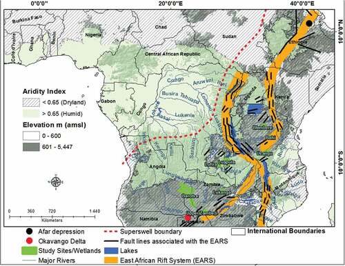
The focus of the study is on six large wetlands located within and around the African Superswell that are poorly understood from a geomorphological perspective. The wetlands were identified from the Global Lakes and Wetlands Database (GLWD) of Lehner and Döll (Citation2004). These wetlands are greater than 1 000 km2 in size and occur at an altitude above 600 m amsl in climatic settings where MAP/MAE < 0.65. These wetlands are: the Lufira wetland located in southern Democratic Republic of Congo, Bahi, Wembere and Usangu wetlands located in Tanzania, Barotse wetland located in Zambia, and the Upper Zambezi/Sesheke wetland located around the border between Zambia and Namibia (). The African Superswell is the high plateau that rises by more than 1 000 m above the surrounding low-lying areas (McCarthy & Hancox, Citation2000; Pik et al., Citation2006) from east Africa’s Afar depression in Ethiopia to the Cape Fold Mountains in South Africa. Two of the major geological features within the African Superswell are the East African Rift Systems (EARS) and associated fault lines that extend from the Afar depression in east Africa to the Okavango Delta in northern Botswana (Furman et al., Citation2016; McCarthy & Ellery, Citation1994). The present-day topographic and drainage characteristics of the Superswell evolved from the time of the break-up of the Gondwana supercontinent about 180 Ma (Partridge & Maud, Citation1987). The breaking up of the supercontinent left the sub-continent with uplifted margins to the east, south and west. About 60 million years ago a number of streams that drain the interior and smaller coastal streams had cut the uplifted escarpments (Ellery et al., Citation2009). As a result and under current climatic conditions, most streams that drain the interior either join the fewer major river basins, such as the Limpopo, Orange, Great Ruaha, Zambezi and Congo basins, that drain into the Atlantic or Indian Ocean, with only few streams draining into inland basins, such as the Okavango, Wembere and Bahi basins. The sub-continent was again uplifted following two major events that occurred about 30 Ma and 5 Ma. The first uplift event (~30 Ma) was associated with an uplift of between 150 and 300 m while the second event (~5 Ma) elevated the sub-continent by an elevation between 150 and 900 m. The two uplift events severed and diverted existing drainage connections, established new drainage connections through river capture and reactivated channel incision (Moore et al., Citation2007; Nugent, Citation1990; Thomas & Shaw, Citation1988) such that streams in the study area were left in a long-term state of incision.
Figure 1. The distribution of study sites in relation to the continent’s aridity, the African Superswell as well as major fault lines and major rivers (Source of fault lines: Pik et al., Citation2006).
3. Methods
Detailed analysis of topographic information using Shuttle Radar Topographic Mission (SRTM) Digital Elevation Model (DEM) with elevations measured at a 30 m spatial resolution, was undertaken in ArcGIS. LandsatLook images were used for visual analysis and the identification of geomorphic features. Fault lines were digitized from existing literature (i.e. Foster et al., Citation1997; Citation2005; Macheyeki et al., Citation2008). River courses were digitized from Google Earth because the use of automated DEM procedures to generate river courses usually results in spatially dislocated and incorrectly positioned streams (Flügel, Citation2014; Kulawardhana et al., Citation2007), which may lead to incorrect spatial placement and non-detection of fluvial features such as topographic steps and river junctions (Flügel, Citation2014). Elevation values were interpolated to the digitized river from the DEM to plot channel longitudinal profile. Valley cross-sectional profiles were plotted from the DEM. Wetland boundaries were generated from the cut-and-fill method as detailed by Lidzhegu et al. (Citation2020b) while catchment boundaries were delineated from automated DEM procedures. To identify lithological and tectonic influences on wetland formation and dynamics, wetland boundaries were overlaid over the 2009 Geological Map of the Southern African Development Community (SADC) Countries provided by the South African Council for Geoscience at a scale of 1:2,500,000.
4. Results
4.1 Geomorphic origin of floodplain wetlands
Wetlands presented in this section are floodplain wetlands that occur in broad and gently sloping valleys upstream of a resistant lithology. However, their origin, sedimentological processes, geological characteristics, and geomorphological features differ. These wetlands are the Lufira wetland located in the Democratic Republic of Congo ()), the Barotse wetland situated in western Zambia ()), and the Upper Zambezi wetland situated on the broader between Zambia and Namibia ()).
Figure 2. LandsatLook images of (a) the Lufira wetland on 5 November 2014, (b) the Barotse wetland on 28 April 2015 and (c) the Upper Zambezi wetland on 17&24 October 2013. Graphs (a1), (b1) and (c1) show valley cross sectional profiles of lines 1 to 5 in (a), (b) and (c) respectively with cross sectional profile 5 in (a1) plotted against the secondary axis. Google Earth imagery (a2) and (b2) are enlarged areas in (a) and (b) respectively (Source: Google Earth’s DigitalGlobe and CNES/Airbus).
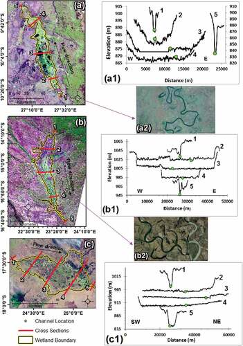
The topographic characteristics of the Lufira wetland shows that upstream (cross-sectional profile 1) and downstream (cross-sectional profile 5) of the wetland, valleys are v-shaped and do not support any wetland habitats (1)). However, the valley between these two confined valleys is broad and supports the wetland (cross-sectional profiles 2 to 4). The channel is generally elevated above the wetland area (cross-sectional profiles 2 to 4) and the wetland is characterized by backwater depressions within the middle reaches. The valley characteristics of both the Barotse and Upper Zambezi wetlands are similar to those of the Lufira wetland in a sense that these wetlands occupy broad valleys (cross-sectional profiles 2 to 4) upstream (cross-sectional profile 5) and downstream (cross-sectional profile 1) of confined valleys that do not support any wetland habitats (1,c1)). However, the two wetlands differ with the Lufura wetland in a sense that both wetlands lack backwater depressions and the channel within the Barotse and Upper Zambezi wetlands is generally at an elevation that is below the surrounding wetland areas. Furthermore, the Lufira wetland is characterized by a meandering stream with visible ox bow lakes, meander scars and cut banks ()). Although the Barotse wetland is characterized by multiple channels, the floodplain is characterized by visible meander scars and sediment bars/point bars inside of meander bends ()), which are characteristics of meandering streams.
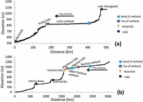
The longitudinal profile of the Lufira River shows that the river is characterized by two major topographic steps ()). One is located downstream of Lake Tshangalele and the other at the Kiubo Falls. The overlay of points depicting locations of the toe and head of the wetland over the longitudinal profile shows that the toe of the wetland is located at the Kiubo Falls. Similarly, the longitudinal profile of the Zambezi River shows that the river is characterized by a series of topographic steps that either coincide with lakes or waterfalls ()). The overlay of points depicting locations of the top and bottom of the wetlands over the longitudinal profile of the Zambezi River shows that the toes of the Barotse and Upper Zambezi wetlands coincide with small topographic steps at the Ngonye Falls and Mambova Falls, respectively. This suggests that the toes of the Lufira, Barotse and Upper Zambezi wetlands coincide with lithologies that could be resistant to channel incision such that they can support waterfalls and the observed topographic steps.
Figure 3. Channel longitudinal profiles including the location of wetlands, lakes and waterfalls, with (a) showing that of the Lufira River and (b) showing that of the Zambezi River.
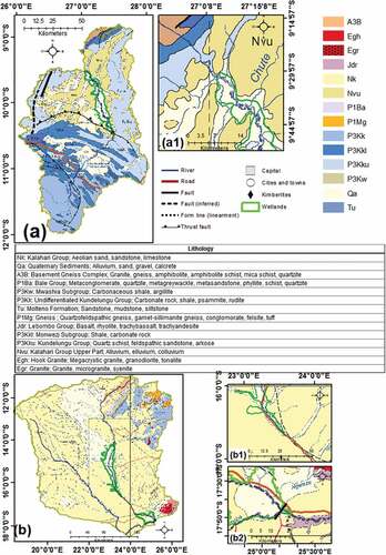
The overlay of the Lufira wetland boundary over a Geological Map of the Southern African Development Community ()) shows that the catchment is mainly characterized by rocks such as the metamorphic rocks of the Kundelungu Group (P3Kku) and consolidated sedimentary rocks of the Monwezi Subgroup (P3Kkl). The wetland area occupies lithologies that are typically of unconsolidated sediments of the Kalahari Group Upper Part (Nvu) and Quaternary Sediments (Qa) associated with floodplain deposits. The area around and below the Kiubo Falls and the toe of the wetland is characterized by Kundelungu Group sediments ()), which are resistant to weathering and erosion as the strata are lithified quartzitic metamorphic rocks. The catchment area of both the Barotse and the Upper Zambezi wetlands is characterized mainly by unconsolidated Aeolian sand and sedimentary rocks of the Kalahari Group (Nk) as well as the unconsolidated Quaternary Sediments (Qa; )). The toes of the Barotse and Upper Zambezi wetlands coincide with changes in the lithology from Quaternary Sediments (Qa) to the Kalahari Group (i.e. the Barotse wetland; 1)) and from unconsolidated sediments (Qa) to the Lebombo Group (Jdr) of volcanic rocks, such as basalt and rhyolite (i.e. the Upper Zambezi wetland; 2)). However, the toe of the Upper Zambezi wetland coincides with a significant fault line that is almost perpendicular to the orientation of the wetland. Although the Kalahari Group may be more resistant to channel incision than the Quaternary Sediments, both the Quaternary Sediments and the Kalahari Group are prone to channel incision. Therefore, the Kalahari Group at the toe of the Barotse wetland is unlikely to support the topographic step at the Ngonye Falls. However, it is likely that there is a resistant lithology supporting the Ngonye Falls.
Figure 4. Catchment geological maps, with (a) showing the geological map of Lufira wetland’s catchment, with (b) showig the catchment of the Barotse and Upper Zambezi wetlands. Inserts (a1), (b1) and (b2) show the geological characteristics at the toe of the Lufira, Barotse and Upper Zambezi wetlands respectively.
4.2 Geomorphic origin of depression wetlands
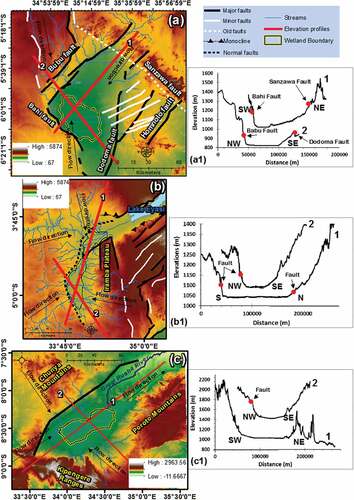
Wetlands presented in this section are depression wetlands with no clearly defined trunk stream through the wetland, therefore ruling out the possibility of their origin being related to the fluvial processes in shaping the landscape. These wetlands are the Bahi wetland ()), the Wembere wetland ()), and the Usangu wetland ()) located in Tanzania. These wetlands are bounded by fault lines and characterized by short streams that emanate from the surrounding uplands to enter the wetlands in a radial pattern (). The south-west to north-east and north-west to south-east elevation profile () and profiles 1 and 2 in 1)) show that steep escarpments that bound the Bahi wetland depression to the south-west, north-east, north-west and south-east coincide with fault lines. Similarly, the elevation profiles of lines 1 and 2 in ) show that the escarpments that bound the Wembere wetland’s depression to the west, north and south of the wetland coincide with fault lines (1)). With regard to the Usangu wetland, the south-west to north-east elevation profile (line 1 in )) shows that the wetland depression is bounded by a steep escarpment to the south-west while a series of lower-lying ridges occur to the north-east (1)). The north-west to south-east orientated elevation profile (line 2 in 5c) shows that the wetland depression is bounded by steep escarpments to the north-west and south-east (1)). The steep slope from the wetland towards the north-western escarpment coincides with a fault line.
Figure 5. The topography and fault lines around (a) Bahi, (b) Wembere, and (c) Usangu wetlands. Graphs (a1) to (c1) show the elevation profiles of lines 1 and 2 in (a) to (c1) respectively.
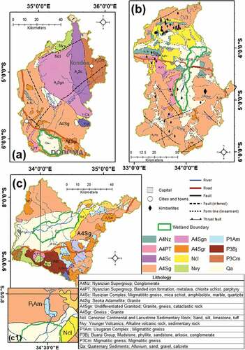
The geology of the Bahi, Wembere and Usangu wetlands’ catchments is largely composed of volcanic rocks of the Seoka Adamellite (A4Sg) while the wetlands overlay unconsolidated Quaternary Sediments (Qa; ). Undifferentiated Granitoid (A4Sgn), as well as Migmatitic rocks of the Rusizian Complex (A4Sc) and Migmatitic Gneiss (P3Cm) are some of the extensive lithologies of the Bahi wetland’s catchment ()). Cenozoic Continental and Lacustrine Sedimentary Rock (Ncl), as well as Nyanzanian Supergroup (A4PT) of a combination of volcanic (i.e. metalava) and metamorphic (chlorite schist) rocks cover some parts of the Wembere wetland’s catchment ()). Baunji Group (P3Bj) of a combination of sedimentary and metamorphic rocks and Younger Volcanic (Nvy) of a combination of volcanic and sedimentary rocks dominate in the northern and south eastern parts of the Usangu catchment ()). While the Bahi and Wembere wetlands are endorheic basins, the area downstream of the toe of the Usangu wetland is characterized by a change in lithology from the easily erodible Quaternary Sediments (Qa) to the more resistant granite rock of the Seoka Adamellite and the migmatite gneiss of the Usugaran Complex (P1Am; 1)).
Figure 6. Catchment geological maps, with (a) to (c) showing the catchments of Bahi, Wembere and Usangu wetlands’ catchments respectively.
5. Discussion
5.1 Geomorphic origin of fluvially controlled wetlands
Although a much larger and tectonically controlled Paleo-Lake Lufira is believed to have once occupied the Lufira depression where the present day Lufira wetland is located (Broadley & Cotterill, Citation2004; Cotterill, Citation2004), the Lufira wetland appears to be fluvially controlled. The processes leading to the formation of the wetland appear to be similar to processes that led to the formation of the Barotse wetland and those described by Tooth et al. (Citation2002). Similar to the Klip River wetland (Tooth et al., Citation2002), the Lufira and Barotse wetlands occupy wide valleys characterized by meandering streams and overlaying less resistant lithologies upstream of narrow valleys characterized by straight channels and overlaying resistant lithologies. According to Tooth et al. (Citation2002) the resistant lithology at the toe of the Klip River wetland acted as a local base level. The channel responded to the base-level by increasing sinuosity upstream, widening the valley, ultimately lowering valley slope and creating conditions suitable for wetland formation. With regard to the formation of the Lufira wetland, the Lufira River that is responsible for its formation rises from the Katanga plateau south of the wetland and drains into Lake Upemba north-east of the wetland. The formation of Lake Upemba has been linked to faulting associated with the second uplift event that occurred about 5 Ma (Broadley & Cotterill, Citation2004; Burke & Gunnell, Citation2008; Cotterill, Citation2004). Therefore, faulting around Lake Upemba (Cotterill, Citation2004) could have lowered the base level of the Lufira River and initiated headward erosion, leading to the capture and desiccation of Palaeo-Lake Lufira. Subsequently, the Lufira River could have incised into the bed of Palaeo-Lake Lufira until the channel bed overlay the metamorphic Kundelungu Group at the Kiubo Falls such that the resistant lithology acts as a local base level. The channel could have responded to the base-level by increasing sinuosity upstream, widening the valley, ultimately lowering valley slope and creating conditions suitable for wetland formation.
With regard to the Barotse wetland, the observed topographic step at the toe of the wetland and meandering scars suggest that the wetland is likely to be fluvially controlled. The lack of fault lines around the wetland suggests that the wetland is not tectonically controlled. The coincidence of the toe of the wetland with the Ngonye Falls suggests a possible resistant lithology although the current study shows a less resistant Kalahari Group. This can be attributed to the poor scale (i.e. 1:2,500,000) of the Geological map used since the exposed lithology at the Ngonye Falls is believed to be Karoo Basalt (Thomas et al., Citation2000; Wellington, Citation1949). According to Nugent (Citation1990) and Moore et al. (Citation2007), the base level of the Zambezi River was significantly lowered in association with the uplift events of the last 30 Ma, which initiated channel incision. However, since the upper and lower Zambezi Rivers are believed to have evolved as separate systems (Stankiewicz & de Wit, Citation2006; Thomas & Shaw, Citation1988), erosion within the Barotse basin could have been initiated subsequent to the capture of Palaeo-Lake Makgadikgadi and the upper Zambezi by the middle Zambezi in the Pleistocene (Moore et al., Citation2007; Nugent, Citation1990; Thomas & Shaw, Citation1988). This is because the Barotse wetland is located upstream of the basin that is believed to have previously hosted Palaeo-Lake Makgadikgadi and the Palaeo-Lake could have acted as the base level of the upper Zambezi River. Subsequent to the capture of Palaeo-Lake Makgadikgadi, erosion could have lowered the bed of the upper Zambezi River to a point where, at the Ngonye Falls, the channel bed overlay Karoo Basalt (Thomas et al., Citation2000; Wellington, Citation1949). Subsequently, there must have been longitudinal slope reduction and valley widening as described by the Tooth et al. (Citation2002) model such that conditions become favourable for wetland formation.
5.2 The structure and evolution of fluvially controlled wetlands
The catchment of the Lufira wetland is mainly dominated by consolidated metamorphic and sedimentary rocks such that weathering produces sediment that includes a large proportion of fine material. Deposition of sediment during floods therefore leads to aggradation of the channel margin and the formation of an active meandering channel. Overbank aggradation is associated with the formation of an alluvial ridge and backwater depressions such that the wetland shows high water storage potential within the backwater depressions. Although the alluvial ridge persists throughout the wetland, the alluvial ridge is more pronounced in the upper reach compared to the middle and lower reaches. The predominance of this alluvial ridge in the upper reaches of the wetland suggests that most of the sediment supplied to the system is deposited within the upper reaches. With regards to the Barotse wetland, the channel is the lowest elevated feature across the wetland such that the wetland valley is near-horizontal with no alluvial ridge and backwater depressions present down its length. Given that the catchment of the Barotse wetland is composed mainly of unconsolidated Kalahari Group sediments, sediment is transported mainly as bedload. This means that deposition of sediment is confined to the channel bed as well as channel bars and overbank deposition is therefore limited (McCarthy & Ellery, Citation1998). The geology of the catchment therefore contributes to a near-horizontal floodplain form and an inundation regime that does not promote storage of large volumes of water in backwater depressions.
5.3 The origin, structure, and evolution of tectonically controlled wetlands
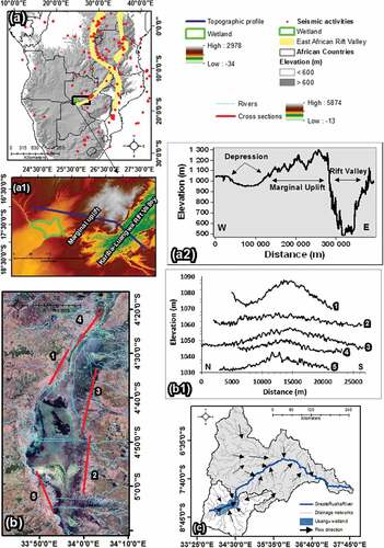
The geological map of the Upper Zambezi wetland also known as Sesheke Maramba floodplain (Hughes & Hughes, Citation1992) shows that the toe of the wetland is characterized by a change in lithology from Kalahari Group sediments to Lebombo Group volcanic rocks. The resistant lithology at the toe of the wetland was also observed by Thomas and Shaw (Citation1998) who reported that the Mambova fault coincides with Karoo basalt. Basalt is more resistant to weathering and erosion than the Kalahari Group sediments, such that erosion of the valley is limited in an upstream direction. Therefore, the Tooth et al. (Citation2002) model may explain the origin of the wetland, except that the absence of meandering streams in the Upper Zambezi wetland and the observed fault line at the toe of the wetland that is coincident with a small but marked ridge downstream of the wetland, suggest that the wetland could be tectonically controlled.
The analysis of the topographic settings around the Upper Zambezi wetland in relation to the south-westward extending arm of the East Africa Rift System shows that rifting could have significantly influenced local slope and ultimately shaped the formation of the wetland (,a1,a2)). The topographic profile of the section that is oriented sub-parallel with the wetland to the north (1,a2)) shows that the wetland occupies a depression to the west of the uplifted shoulders of the rift valleys. The observed fault line at the toe of the wetland suggests a tectonic influence on the topographic characteristics around the wetland. Therefore, coupled with faulting, the uplifted margin of the Luangwa-Kariba rift valley could have played a role in reducing local slopes to the west of the uplifted rift margin and thus leading to the formation of the basin that now hosts the Upper Zambezi wetland. However, the basin hosting the wetland is also believed to have previously hosted Palaeo-Lake Makgadikgadi. Faulting and the uplifted margin of the Luangwa-Kariba rift valley could have initially resulted in the formation of Palaeo-Lake Makgadikgadi. Therefore, the wetland could be a remnant of Palaeo-Lake Makgadikgadi (Nugent, Citation1990) that formed from faulting subsequent to the first (~30 Ma) uplift event (Moore et al., Citation2007; Stankiewicz & de Wit, Citation2006). Headward erosion of the middle Zambezi River is believed to have breached the Mambova Fault at the toe of the wetland and led to the desiccation of Palaeo-Lake Makgadikgadi in the Pleistocene (Moore et al., Citation2007). The Karoo Basalt at the toe of the wetland could have acted as a local base level thus preventing the middle Zambezi River from cutting into the Palaeo-Lake bed such that the partially preserved Palaeo-Lake bed created conditions suitable for wetland formation.
Figure 7. Wetland topographic characteristics, with (a) and (a1) showing topographic characteristics around the Upper Zambezi wetland and (a2) shows the elevation profile of the blue line in (a1). The LandsatLook images (16&23 September 2006) in (b) and graph (b1) shows the southern section of the Wembere wetland and the elevation profile of lines 1 to 5 in (b), and (c) shows drainage networks within the Usangu wetland and the Great Ruaha River Catchments.
The formation of the Wembere, Bahi, and Usangu wetlands appear to be tectonically controlled as the wetlands are bounded by fault lines and occur within the East African Rift System. According to Foster et al. (Citation1997), within the Wembere area, volcanism and sedimentation could have begun about 5 Ma. Major fault escarpments could have formed about 3 Ma and the present-day rift escarpments could have developed about 1.2 Ma. According to Macheyeki et al. (Citation2008), the Bahi wetland occupies a half graben that is an extension of the eastern branch of the East African Rift System. Macheyeki et al. (Citation2008) highlighted that the fault lines that bound the wetland could be related to rifting associated with the East African Rift System. The Usangu wetland is of tectonic origin since it occupies the Ruaha-Usangu depression that is a southward extension of the eastern branch of the East African Rift System (Delvaux & Hanon, Citation1993). According to SMUWC (Citation2001), the Usangu wetland occurs in a fault-controlled basin that is filled with lake deposits. Judging from the short length and orientation of streams that flow into each of these wetlands, the formation of the Wembere, Bahi, and Usangu graben structures could have diverted the drainage into the depressions, with subsequent flooding leading to wetland formation.
With regard to the evolution of tectonically controlled wetlands, the observed conical shape of elevation profiles across areas where tributary streams enter the southern section of the Wembere wetland suggests that each tributary is associated with an alluvial fan as it enters the Wembere wetland basin (,b1)). The observed sedimentation may ultimately lead to the evolution of the wetland into a complex wetland system that is controlled in fundamental ways by these impinging alluvial fans. Judging from the orientation of the drainage network of the Usangu wetland catchment in comparison to the orientation of the drainage network of the Great Ruaha River catchment ()), rifting could have diverted the drainage into the wetland forming an endorheic basin. Therefore, headward erosion of the Great Ruaha River could have led to partial desiccation of the lake and the formation of the wetland such that the resistant lithology at the toe of the wetland prevents the Great Ruaha River from incising further into the wetland.
5.4 Incorporation of geological and geomorphological processes in a model of wetland formation and dynamics
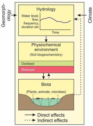
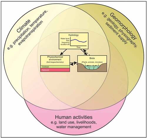
Currently, the hydrological regime is regarded as the primary determinant of wetland structure and functioning (e.g., Halabisky et al., Citation2016; House et al., Citation2016; Mitsch & Gosselink, Citation2015). This understanding was originally presented by the Gosselink and Turner (Citation1978) conceptual model that illustrates that prolonged flooding directly modifies soil chemical and physical properties, particularly through reduction in oxygen availability in the root zone. However, flooding should be sufficiently shallow to allow the establishment of macrophytes that are adapted to tolerate anaerobic conditions in the root zone. These characteristics are summarized in , which illustrates the relationship between basin physiography and climate, which are viewed as given externalities. The hydrological regime (depth, duration and frequency of inundation) leads to modification of edaphic characteristics, and the biotic response to flooding of soils gives rise to an ecosystem with plants and animals adapted to these conditions.
Figure 8. Conceptual model of wetland formation showing a relationship between hydrology, edaphic and biotic characteristics of wetlands (modified after Gosselink & Turner, Citation1978 and Mitsch & Gosselink, Citation2015).
The current study has shown that, through the influence on basin form and hydrology, tectonic activities have played a major role in the formation of depressions with broad low gradient valley floors that accommodate wetlands in Africa’s elevated drylands. Tectonic processes may lead to the formation of rifted depressions such as the Bahi and Wembere wetlands, or to the formation of shallow and deep depressions between rift valleys such as the Upper Zambezi wetland and Lake Victoria. Lake Victoria is believed to have formed within a tectonic sag between the uplifted shoulders of the eastern and western branches of the East African Rift Systems (Johnson et al., Citation2000; Scholz et al., Citation1990). The subsequent formation of tectonic depressions diverted drainage into the newly formed depressions with the subsequent flooding resulting in the formation of wetlands such as the Usangu, Wembere, and Bahi wetlands. The current study has shown that fluvial processes play an important role in the formation and modification of broad valleys with near-horizontal cross-sections and gentle longitudinal slopes suitable for wetland formation. Wetlands such as the Barotse and Lufira occupy reaches which overlay easily eroded lithologies upstream of a resistant lithology. Increased lateral channel migration and avulsions upstream of the resistant lithology have led to the formation of broad and gently sloping valleys suitable for wetland formation.
Catchment geology and the associated sedimentological characteristics play an important role in shaping wetland structure and evolution. Sedimentation processes modify the morphology of valleys and tectonic depressions through aggradation processes that determine the morphology of the wetland system. For instance, the formation of an alluvial ridge as observed down the length of the Lufira wetland appears to be influenced by the quantity and nature of sediment supplied to the wetland. The Lufira wetland catchment is mainly composed of consolidated metamorphic and sedimentary rocks that weather to give rise to a range of particle sizes from sand to silt and clay. However, the catchment of the Barotse wetland is mainly composed of unconsolidated Kalahari sands such that streams transport mainly bedload sediment. Overbank deposits of fine material have resulted in the construction of an alluvial ridge down the length of the Lufira wetland, while bedload deposits of unconsolidated Kalahari sands within the Barotse wetland have resulted in the formation of a multi-channelled valley with a near-horizontal cross-section.
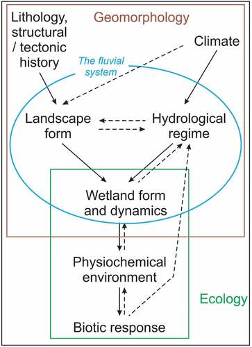
The role that geomorphology plays in determining wetland origin is increasingly acknowledged and this is evident from detailed conceptual models (e.g., Tooth et al. (Citation2002) and M. C. Grenfell et al. (Citation2008) models) which are used to describe specific geomorphological processes leading to the formation of different wetland types. Yet, generic wetland conceptual models that seek to explain the occurrence of wetlands in general have, and continue to overlook the role that geological and fluvial geomorphological processes play in the creation of broad (near-horizontal in cross-section) and gently sloping valleys (longitudinally) which support wetland formation. This is evident from the Gosselink and Turner (Citation1978) model and the Tooth et al.’s (Citation2015) modification of the Gosselink and Turner (Citation1978) conceptual model that places the hydrological regime within the broader framework of climate, geomorphology, and human activities as they relate to wetland origin, structure and hydrological functioning (). Nonetheless, the Tooth et al. (Citation2015) model does reveal that the influence of the hydrological regime on wetland formation and dynamics is a result of the interactions between geomorphology, climate and human activities. However, current and detailed conceptual models such as the Tooth et al. (Citation2002) and M. C. Grenfell et al. (Citation2008) models provided adequate knowledge to incorporate into a conceptual model that places appropriate emphasis on geomorphological processes as a primary determinant of wetland origin, structure and dynamics.
Figure 9. Conceptual model of wetland formation showing the influence of hydrology on wetland structure and function, and the biotic feedbacks that affect wetland hydrology as a result of the interaction between geomorphology, climate and human activities (modified from Tooth et al., Citation2015).
Lithological characteristics together with structural and tectonic processes exert long-term effects on physiographic characteristics at a continental to sub-continental scale. Crustal sagging associated with the formation of rift valleys forms basins into which water flows. However, on elevated land surfaces that are primarily erosional, resistant lithologies act as base levels of fluvial systems. In combination with climate, physiography is modified through weathering, erosion, and deposition, to produce a landform that is shaped primarily by the fluvial system (). Structuring of wetlands primarily by fluvial processes may occur in settings with a stable land surface and a local base level that is resistant to erosion. The Lufira and Barotse wetlands seem to illustrate such wetland landforms. In both cases, valleys have been widened and longitudinal slope lowered by fluvial processes upstream of a resistant lithology, to create an environment suited to wetland formation. Climate produces runoff that leads to flooding of parts of the Earth’s surface, such that water may simply drain into shallow basins, or it may modify basin form through erosion and deposition that lead to the formation of broad valleys with a gentle longitudinal slope. The morphology and dynamics of some wetlands is therefore as much a product of how flowing water interacts with and modifies a landscape to produce a landform that floods to a shallow depth for prolonged periods, as they are about the water itself. Once a wetland landform has been created through processes of erosion and deposition, it is then appropriate to consider the effect of the hydrological regime on soil biogeochemistry and biota, as discussed by Gosselink and Turner (Citation1978).
Figure 10. Conceptual model of wetland formation showing the role of geomorphological processes on wetland formation while incorporating the influence of prolonged flooding on the physiochemical and biotic characteristics of a wetland.
5. Conclusion
This study has shown that geological processes and fluvial geomorphic processes affect wetland origin and structure. Tectonic activities through both the formation of rift valleys and through marginal uplift of rift margins lead to depressions that host endorheic wetlands (e.g. Bahi wetland) or wetlands with a very low longitudinal slope where rift margin uplift reduces valley longitudinal slope such that low-gradient wetlands form that are weakly affected by fluvial processes (e.g. Upper Zambezi wetland). The origin and structure of those wetlands in elevated settings in landscapes that are broadly erosional, are influenced primarily by fluvial processes interacting with underlying lithologies, such that over long periods of time, local base levels made of resistant lithologies that weather and erode far more slowly than lithologies upstream that weather and erode far more rapidly (e.g. Lufira wetland). In these cases, the stream upstream of the resistant lithology erodes its bed to one that is appropriate for the available discharge, after which the stream starts to meander such that meander migration planes the valley laterally to create a broad valley with a near-horizontal cross-section and a very gentle longitudinal slope (Tooth et al. Citation2002). The conceptual model that we present illustrates the broader context of wetland development than has been presented up to now, focusing on how geological and hydrological processes interact to produce landforms that host wetlands. Unless these processes are examined and understood, wetland managers may consider natural processes such as channel avulsion, to be a consequence of human activities in the wetland or the catchment, and intervene to return flow down the original watercourse. Such an intervention is likely to be inappropriate and in some cases may be impossible to achieve without considerable costs and potentially negative consequences. Although the current study has shown that abductive analysis of wetland features and associated processes using remotely sensed data and GIS methodologies can provide a better understanding of the geomorphological origin, structure and evolution of wetlands, abductive analysis can be verified through field surveys where such surveys are practical.
Disclosure statement
No potential conflict of interest was reported by the author(s).
References
- Broadley, D. G., & Cotterill, F. P. D. (2004). The reptiles of southeast Katanga, an overlooked “hot spot.”. African Journal of Herpetology, 53(1), 35–61. https://doi.org/10.1080/21564574.2004.9635497
- Burke, K., & Gunnell, Y. (2008). The African erosion surface: A continental-scale synthesis of geomorphology, tectonics and environmental change over the past 180 million years. Geological Society of America Memoir, 201, 66. https://doi.org/10.1130/2008.1201
- Chorowicz, J. (2005). The East African rift system. Journal of African Earth Sciences, 43(1–3), 379–410. https://doi.org/10.1016/j.jafrearsci.2005.07.019
- Cotterill, F. P. D. (2004). Drainage evolution in south-Central Africa and vicariant speciation in swamp-dwelling weaver birds and swamp flycatchers. The Honeyguide, 50(1), 7–25. http://refhub.elsevier.com/S1055-7903(20)30260-8/h0080
- Delvaux, D. F., & Hanon, M. (1993). Neotectonics of the Mbeya Area, SW Tanzania. Royal Museum for Central Africa, Department of Geology and Mineralogy, B-3080 Tervuren (Belgium), 87–97.
- Ellery, W. N., Grenfell, M., Grenfell, S., Kotze, D. C., McCarthy, T. S., Tooth, S., Grundling, P. L., Beckedahl, H., Le Maitre, D., & Ramsay, L. (2009). WET-origins: Controls on the distribution and dynamics of wetlands in South Africa. Water Research Commission Report No TT 334/09.
- Ellery, W. N., & McCarthy, T. S. (1994). Principles for the sustainable utilization of the Okavango Delta ecosystem, Botswana. Biological Conservation, 70(2), 159–168. https://doi.org/10.1016/0006-3207(94)90284-4
- Flügel, T. J. (2014). The evolution of the Congo-Kalahari watershed: African mega–geomorphology. (PhD Thesis). University of Cape Town.
- Foster, A., Ebinger, C., Mbede, E., & Rex, D. (1997). Tectonic development of the northern Tanzanian sector of the East African Rift System. Journal of the Geological Society, 154(4), 689–700. https://doi.org/10.1144/gsjgs.154.4.0689
- Furman, T., Nelson, W. R., & Elkins-Tanton, L. T. (2016). Evolution of the East African Rift: Drip magmatism, lithospheric thinning and mafic volcanism. Geochimica Et Cosmochimica Acta, 185(2016), 418–434. https://doi.org/10.1016/j.gca.2016.03.024
- Gosselink, J. G., & Turner, R. E. (1978). The role of hydrology in freshwater wetland ecosystems. In R. E. Good, D. F. Whigham, and R. L. Simpson (Eds.), Freshwater wetlands: Ecological processes and management potential. (pp. 63–78). Academic Press.
- Grenfell, M. C., Ellery, W., & Grenfell, S. E. (2008). Tributary valley impoundment by trunk river floodplain development: A case study from the KwaZulu-Natal Drakensberg toe hills, Eastern South Africa. Earth Surface Processes and Landforms, 2044(33), 2029–2044. https://doi.org/10.1002/esp.1652
- Grenfell, S. E., Ellery, W. N., Grenfell, M. C., Ramsay, L. F., & Flügel, T. J. (2010). Sedimentary facies and geomorphic evolution of a blocked-valley lake: Lake Futululu, northern Kwazulu-Natal, South Africa. Sedimentology, 57, 1159–1174. https://doi.org/10.1111/j.1365-3091.2009.01141.x
- Halabisky, M., Moskal, L. M., Gillespie, A., & Hannam, M. (2016). Reconstructing semi-arid wetland surface water dynamics through spectral mixture analysis of a time series of Landsat satellite images (1984-2011). Remote Sensing of Environment, 177, 171–183. https://doi.org/10.1016/j.rse.2016.02.040
- House, A. R., Thompson, J. R., & Acreman, M. C. (2016). Projecting impacts of climate change on hydrological conditions and biotic responses in a chalk valley riparian wetland. Journal of Hydrology, 534, 178–192. https://doi.org/10.1016/j.jhydrol.2016.01.004
- Hughes, D. A., Tshimanga, R. M., Tirivarombo, S., & Tanner, J. (2014). Simulating wetland impacts on stream flow in Southern Africa using a monthly hydrological model. Hydrological Processes, 28(4), 1775–1786. https://doi.org/10.1002/hyp.9725
- Hughes, R. H., & Hughes, J. S. (1992). A directory of African wetlands. IUCN.
- Johnson, T. C., Kelts, K., & Odada, E. (2000). The Holocene history of Lake Victoria. Ambio: A Journal of the Human Environment, 29(1), 2–11. https://doi.org/10.1579/0044-7447-29.1.2
- Joubert, R., & Ellery, W. N. (2013). Controls on the formation of Wakkerstroom Vlei, Mpumalanga province, South Africa. African Journal of Aquatic Science, 38(2), 135–151. https://doi.org/10.2989/16085914.2012.762897
- Kim, C. J. (2002). Inferences frequently used in earth science. Journal of Korean Earth Science Society, 23(2), 188–193. https://www.koreascience.or.kr/article/JAKO200220417573317.page
- Kulawardhana, R. W., Thenkabail, P. S., Vithanage, J., Biradar, C., Islam, M. A., Gunasinghe, S., & Alankara, R. (2007). Evaluation of the wetland mapping methods using Landsat ETM+ and SRTM Data. Journal of Spatial Hydrology, 7(2), 62–96. http://eomf.ou.edu/media/docs/upload/Wetlands__JoSH_2007.pdf
- Larkin, Z. T., Ralph, T. J., Tooth, S., & McCarthy, T. S. (2017). The interplay between extrinsic and intrinsic controls in determining floodplain wetland characteristics in the South African drylands. Earth Surface Processes and Landforms, 42(7), 1092–1109. https://doi.org/10.1002/esp.4075
- Lehner, B., & Döll, P. (2004). Development and validation of a global database of lakes, reservoirs and wetlands. Journal of Hydrology, 296(1–4), 1–22. https://doi.org/10.1016/j.jhydrol.2004.03.028
- Lidzhegu, Z., Ellery, F., & Mantel, S. K. (2020a). Incorporating geomorphic knowledge in the management of Wetlands in Africa’s Drylands: A rapid assessment of the Kafue Wetland. Wetlands, 40(2), 391–405. https://doi.org/10.1007/s13157-019-01172-9
- Lidzhegu, Z., Ellery, W. N., Mantel, S. K., & Hughes, D. A. (2020b). Delineating wetland areas from the cut-and-fill method using a Digital Elevation Model (DEM). South African Geographical Journal, 102(1), 97–115. https://doi.org/10.1080/03736245.2019.1638825
- Macheyeki, A. S., Delvaux, D., De Batist, M., & Mruma, A. (2008). Fault kinematics and tectonic stress in the seismically active Manyara–Dodoma Rift segment in Central Tanzania – Implications for the East African Rift. Journal of African Earth Sciences, 51(4), 163–188. https://doi.org/10.1016/j.jafrearsci.2008.01.007
- McCarthy, T. S., & Ellery, W. N. (1994). The effect of vegetation on soil and ground water chemistry and hydrology of Islands in the seasonal swamps of the Okavango Fan, Botswana. Journal of Hydrology, 154(1–4), 169–193. https://doi.org/10.1016/0022-1694(94)90216-X
- McCarthy, T. S., & Ellery, W. N. (1998). The Okavango Delta. Transactions of the Royal Society of South Africa, 53(2), 157–182. https://doi.org/10.1080/00359199809520384
- McCarthy, T. S., & Hancox, P. J. (2000). Wetlands. In T. C. Patridge, and R. R. Maud (Eds.), The Cenozoic of Southern Africa. (pp. 218-235). Oxford University Press .
- McCarthy, T. S., Tooth, S., Kotze, D. C., Collins, N. B., Wandrag, G., & Pike, T. (2010). The role of geomorphology in evaluating remediation options for floodplain wetlands: The case of Ramsar-listed Seekoeivlei, eastern South Africa. Wetlands Ecology and Management, 18(2), 119–134. https://doi.org/10.1007/s11273-009-9153-7
- Mitsch, W. J., & Gosselink, J. G. (2015). Wetlands. John Wiley and Sons.
- Moore, A. E., Cotterill, F. P. D., Main, M. P. L., & Williams, H. B. (2007). The Zambezi River. In A. Gupta (Ed.), Large rivers: Geomorphology and management. (pp. 311-331). John Wiley and Sons.
- Nugent, C. (1990). The Zambezi River: Tectonism, climatic change and drainage evolution. Palaeogeography, Palaeoclimatology, Palaeoecology, 78(1–2), 55–69. https://doi.org/10.1016/0031-0182(90)90204-K
- Oh, P. S. (2019). Features of modeling-based abductive reasoning as a disciplinary practice of inquiry in earth science cases of novice students solving a geological problem. Science & Education, 28(6–7), 731–757. https://doi.org/10.1007/s11191-019-00058-w
- Partridge, T., & Maud, R. (1987). Geomorphic evolution of Southern Africa since the Mesozoic. South African Journal of Geology, 90(2), 179–208. https://journals.co.za/doi/10.10520/AJA10120750_958
- Pik, R., Marty, B., & Hilton, D. R. (2006). How many mantle plumes in Africa? The geochemical point of view. Chemical Geology, 226(3–4), 100–114. https://doi.org/10.1016/j.chemgeo.2005.09.016
- Pulley, S., Ellery, W. N., Lagesse, J. V., Schlegel, P. K., & McNamara, S. J. (2018). Gully erosion as a mechanism for wetland formation: An examination of two contrasting landscapes. Land Degradation and Development, 29(6), 1756–1767. https://doi.org/10.1002/ldr.2972
- Rhoads, B. L., & Thorn, C. E. (1993). Geomorphology as science: The role of theory. Geomorphology, 6(4), 287–307. https://doi.org/10.1016/0169-555X(93)90052-4
- Scholz, C. A., Rosendahl, B. R., Versfelt, J. W., & Rach, N. (1990). Results of high-resolution echo-sounding of Lake Victoria. Journal of African Earth Sciences, 11(1–2), 25–32. https://doi.org/10.1016/0899-5362(90)90073-N
- SMUWC. (2001). Sustainable management of the Usangu wetland and its catchment. Final Report. United republic of Tanzania.
- Stankiewicz, J., & de Wit, M. J. (2006). A proposed drainage evolution model for Central Africa - Did the Congo flow east?. Journal of African Earth Sciences, 44(1), 75–84. https://doi.org/10.1016/j.jafrearsci.2005.11.008
- Thomas, D. S. G., O’Connor, P. W., Bateman, M. D., Shaw, P. A., Stokes, S., & Nash, D. J. (2000). Dune activity as a record of late Quaternary aridity in the Northern Kalahari: New evidence from northern Namibia interpreted in the context of regional arid and humid chronologies. Palaeogeography, Palaeoclimatology, Palaeoecology, 156(3–4), 243–259. https://doi.org/10.1016/S0031-0182(99)00143-1
- Thomas, D. S. G., & Shaw, P. A. (1988). Late Cainozoic drainage evolution in the Zambezi Basin: Geomorphological evidence from the Kalahari Rim. Journal of African Earth Sciences, 7(4), 611–518. https://doi.org/10.1016/0899-5362(88)90111-X
- Tooth, S., Ellery, W. N., Grenfell, M. C., Thomas, A., Kotze, D. C., & Ralph, T. (2015). 10 reasons why the geomorphology of wetlands is important Wetlands in Drylands Research Network . Retrieved March 07, 2017, Retrieved http://wetlandsindrylands.net/wp-content/uploads/2015/10/10-Reasons-Geomorphology-of-Wetlands-NEAR-FINAL-FULL-COLOUR.pdf
- Tooth, S., McCarthy, T. S., Brandt, D., Hancox, P. J., & Morris, R. (2002). Geological controls on the formation of alluvial meanders and floodplain wetlands: The example of the Klip River, eastern Free State, South Africa. Earth Surface Processes and Landforms, 27(8), 797–815. https://doi.org/10.1002/esp.353
- Tooth, S., & McCarthy, T. S. (2007). Wetlands in drylands: Geomorphological and sedimentological characteristics with emphasis on examples from Southern Africa. Progress in Physical Geography, 31(1), 3–41. https://doi.org/10.1177/0309133307073879
- Wellington, J. H. (1949). Zambezi-Okavango development projects. Geographical Review, 39(4), 552–567. https://doi.org/10.2307/210672
- Zomer, R. J., Trabucco, A., van Straaten, O., & Bossio, D. A. (2006). Carbon, land and water: A global analysis of the hydrologic dimensions of climate change mitigation through afforestation/reforestation. International Water Management Institute.