Abstract
Urban settlements in the Western Cape sustain regional development and are vital to the national spatial economy, but because not all contribute or participate equally they do not grow at the same rate – some flourish while others decline. The Provincial Administration of the Western Cape therefore commissioned a study to evaluate and monitor their functions and performance. This paper assesses the study's methodology and procedures. It describes the variables used and explains how the raw data were transformed into comparative indices and combined into a single composite development potential index. It evaluates the sub-indices and the composite index by mapping the results and uses multivariate statistical techniques to explore the logic and validity of the results. It confirms that the indices created for measuring urban growth potential were well chosen and constructed, laying a sound theoretical and methodological base for future decisions about public investment in rural towns.
1Respectively, Professor (retired); Senior Lecturer; and Research Fellow and Professor (retired), Department of Geography and Environmental Studies, University of Stellenbosch, South Africa.
1. INTRODUCTION
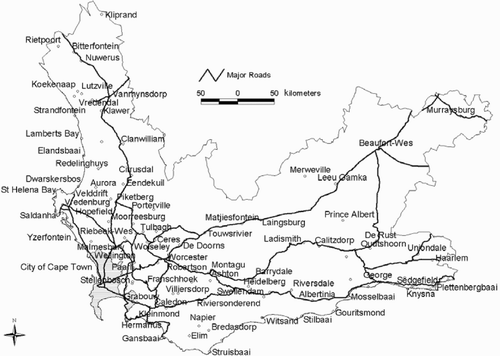
In a province such as the Western Cape, South Africa, urban settlements play an important role in meeting the general needs of its inhabitants. These towns sustain regional development in the province and play a role in the national spatial economy (Van der Merwe, Citation1982, Citation1983; Hardoy & Satterthwaite, Citation1986; Rondinelli, Citation1988, Citation1991; Evans, Citation1992; Ferreira, Citation1992; Gaile, Citation1992). However, not all towns in the region contribute or participate equally in this regard and therefore they do not experience the same growth rates – some are flourishing while others are declining as a result of various forces. About 130 urban settlements () are found outside the Cape Metropole (the area of the Unicity's jurisdiction) in the Western Cape Province. Some of these have a solid socio-economic base and are growing fast, but many other towns are relatively stagnant or are steadily declining economically (Eloff, Citation1979; Deloitte & Touche, Citation1995). These processes affect the levels of social and economic services available to the surrounding farming community.
Figure 1: Western Cape towns
In order to ascertain how the region could be supported optimally by a dynamic system of urban settlements (Johnson, Citation1970; Brutzkus, Citation1975; ESCAP, Citation1979; Rondinelli et al., Citation1979; Meissner, Citation1981; Knesl, Citation1982), it was necessary to evaluate and monitor the functions and performance patterns of the province's towns comprehensively. The problem can no longer be addressed in a random and superficial way. As a result, a study was commissioned by the Provincial Administration of the Western Cape to undertake the required research (Van der Merwe et al., Citation2005). The National Spatial Development Perspective (NSDP) (The Presidency, Citation2003) made such an investigation necessary and left the province with no option other than to take the growth potential of towns seriously.
Informed strategic decision making by relevant role players required the creation of an appropriate spatial database to support a Provincial Spatial Development Framework (PSDF) within the Western Cape. In addition a suitable methodology was needed to translate the data into information pertinent to planning and public investment decisions. The aims of this paper are to present and evaluate the quantitative methodology applied in this report (Van der Merwe et al., Citation2005) for measuring the development potential of towns as required by the NSDP by:
-
describing how the indices for measuring the comparative development potential of towns in the Western Cape Province were calculated; and
-
evaluating the individual and composite indices used.
On the basis of an extensive literature study presented by Van der Merwe et al. Citation(2005) and wide-ranging discussions with specialists in the field of small town and regional development, it was determined that the growth potential of individual towns in the Western Cape Province can best be evaluated objectively through the use of a balanced set of multidimensional criteria that accounts for the diversity and complexity of process dynamics during town development. It was decided that the final set of criteria should incorporate, among others things, the following aspects:
-
inherent economic base of town;
-
demographic structure and migration dynamic;
-
in situ environmental resources;
-
infrastructure and services;
-
hinterland centrality of the town;
-
administrative capacity of the town;
-
location and transport accessibility;
-
town–region links and interaction;
-
urban hierarchy
-
competition amongst towns;
-
metropolitan impact on the town's hinterland;
-
government policy and strategies; and
-
technological and cultural change.
2. DEVELOPMENT OF A GIS DATABASE FOR MEASURING URBAN GROWTH POTENTIAL
The spatial data matrix created consists of the towns in the Western Cape Province (outside the Cape Town metropole) as cases/entities, each evaluated in accordance with a set of quantitative variables synthesised as indicators of urban development. Explanation of the data matrix begins with the selection of towns and the chosen quantitative variables. It then progresses through an exposition of the measurement methodology, followed by the presentation of the quantitative town profiles.
2.1 Selection of towns
The basis for the selection of urban places was the 2001 Population Census. Geographical units made available by this Census qualifying for inclusion were all ‘main places’. There are 341 such individual spatio-statistical units within this subset in the province. The geographical database of the 2001 Population Census contains not only urban polygons,Footnote2 but also the rural polygons surrounding these so-called ‘main places’. Additionally, single urban settlements often consist of multiple polygons, some of which have no urban functions – therefore it was necessary to extract the urban polygons from the database and group these units to represent their respective urban settlements. In order to do this, surface areas were computed for the polygons. These areas were sorted by size and, by inspecting the map, a suitable cut-off value was determined to distinguish the urban from the rural polygons. Once this process was completed, urban polygons belonging to the same urban settlement were recoded and their town names assigned. The total population was calculated for each of these urban settlements. The urban places were ranked on population size and all urban settlements with more than 100 permanent residents were selected for further analysis in the data matrix. These units were mapped and inspected for possible omissions and further grouping. This procedure revealed a few meritorious cases (e.g. Strandfontein, a coastal holiday town) below the cut-off value of 100. These were added to the selected set of urban centres. Seven other small coastal centres that were located close together were grouped with the largest central nucleus in the area and added to the matrix. Twenty black and coloured townships identified as ‘main places’ in the 2001 Population Census were also grouped with their functional counterparts.
This procedure led to the creation of a final set of 131 urban places in the Western Cape Province for which data were collected from various sources to measure their growth potential. The map in displays the geographical locations and distribution of these towns.
Of the province's total population of 4 524 000 (2001 Population Census), approximately 1 631 000 (36 per cent) reside outside the Cape Town Metropolitan Area and of these 1 205 000 (74 per cent) are urban dwellers in the 131 towns under investigation.
2.2 Selection and derivation of quantitative indicators
A set of 64 variables was identified for which information could be obtained for each of the 131 selected towns. The choice of these variables was based on the availability of data, as well as the criteria identified by the literature study. The intention was to measure the required criteria/dimensions of comparative urban growth potential as comprehensively as possible. In line with the NSDP, the variables were grouped into three representative sub-themes – resource, infrastructure and economic indices. Each sub-theme was further subdivided into functional groups of indicators ().
Table 1: Summary of indicators grouping
These themes and sub-themes comply not only with the requirements set out in the NSDP policy document but also with the guidelines distilled from the international literature. Besides giving a spatial cross-sectional perspective on the status quo of the 131 urban places, the study also endeavoured to add a temporal element to the analysis by incorporating population data from the 1991 Population Census. The 1991 data (rather than 1996) were selected because they provided a longer time period for comparing trends. In order to generate a comparable dataset, the 1991 census data were extracted for enumeration areas that spatially approximated the 2001 geographical boundaries of the selected towns. Unfortunately not all towns included in the 2001 Population Census could be matched to specific enumeration areas in 1991. This meant that no data on ‘change’ could be derived for the following small towns in the dataset: Jacobsbaai, Kliprand, Op-die-Berg, Rietpoort, Volmoed, Wemmershoek and Wittedrift. The missing 1991 data for these entities were estimated from the means or the lowest tenth percentile of the data, depending on what was considered to be the most appropriate and representative measure. These places are all very small and, given this caveat, any ‘change’ indicators relating to these settlements should be interpreted with caution.
It is also significant that relative percentages for change measurement rather than absolute numbers were used as input for constructing profiles of the towns. The relevant indices therefore afford the smaller centres equal comparative opportunity to perform against the larger centres. Some of these indices may be statistically somewhat misleading if used indiscriminately in all cases.
A detailed explanation of how the values for different variables in the data matrix were derived is provided here. Combined quantitative indicators indexing each of the urban development dimensions were devised by standardising the selected individual variables and summing the standardised z-scores to derive compound indices. Standardised z-scores are computed by the standard formula:
The z-score of variable k has an average value of zero and a standard deviation of 1.0. This means that towns that have values above the provincial average for a particular variable have positive z-scores, whereas towns that have negative z-scores have values below the provincial average. Those towns with values close to the average have small deviations from zero, whereas those that have large positive or negative z-scores are substantially above or below the mean for the province. As z-scores for different variables are comparable, these were added to create the various composite indices. The index values represent the mean of the z-scores multiplied by 10. This multiplication was done to work with larger, more easily comparable index values. See for details of the specific variables used to create the compound indices as indicators. Each of the indices and its derivation are discussed in the following sections.
Table 2: Indicators of natural resources potential
Table 3: Indicators of human resources potential
Table 4: Indicators of transport and communications
Table 5: Indicators of institutional services
Table 6: Indicators of economic sectors
Table 7: Indicators of commercial services
Table 8: Indicators of market potential
Table 9: Indicators of regional vitality
2.2.1 Natural resources index
The indicators of natural resource potential were derived from eight variables. provides a brief explanation of the data sources and statistical procedures used to generate each of the variables.
The indicators assess the amount of developable land available within the municipal or commonage area. They also take into account the amount of water available, agricultural and tourism potential, and the environmental sensitivity of the municipal area to tourism and other economic activities.
2.2.2 Human resources index
The human resources potential indicators were measured by six variables compounded into two indices. details the data sources and methods used to generate each of the variables. The indicators assess the size and quality of the labour force and also take into account the change in these variables over the preceding ten years.
2.2.3 Transport and communications index
Transport and communication infrastructure was measured by seven variables. provides a description of the data sources and statistical procedures used to generate each of the variables. The indicators assess the availability and accessibility of transport and communication infrastructure. These are measured by the presence of and distance to national or main roads, airports and commercial harbours, and access to cell phone coverage.
2.2.4 Institutional services index
The provision level of public institutional services was measured by nine variables. describes the sources of data and how each of the variables was computed. The indicators measure the types, strength and capacity of public service delivery to the community. These factors are measured by the presence of municipal or other governmental offices, value of the property tax base, and the provision of a variety of institutional services such as educational facilities, and postal and police services.
2.2.5 Economic sectors index
The strength and size of the economic sectors were measured by ten variables. A brief explanation of the data sources and statistical procedures used to generate each of the variables is presented in . The indicators assess the strength of the local economy in terms of the size and composition of the labour force in those sectors of the economy generating primary jobs and income in the primary and secondary sectors, namely agriculture, fishing, mining and manufacturing. They also take into account the diversity of the local economy and it is postulated that greater diversity is beneficial, to shield against the economic fluctuations so detrimental to undiversified monofocused economies. The size of each region's economy is measured by the gross geographical product of the district in which the town is located. Additionally, changes in these variables are measured between 1991 and 2001 in order to include some indication of temporal growth or decline.
2.2.6 Commercial services index
This index is devised to express the size and range of private commercial and professional service functions offered by the towns in the study. Ten key commercial types of activities were selected, as listed in . These services cover the retail, financial and professional services sectors. By including the presence of various retail chains the index also illustrates the confidence of the larger national franchises in the profitability and future market growth potential of towns where these enterprises are located.
2.2.7 Market potential index
The strength and size of a town's market potential was measured by nine variables. presents the data sources and statistical procedures used to calculate each of the variables. The index combines measures of population size in towns with the total gross personal income of their inhabitants and the potential household income of the magisterial district in which the town is located, as well as the density of the population and weighted measures of accessibility to the five major metropolitan centres in South Africa.
2.2.8 Regional vitality index
Whereas most of the other indices are based on measures relating to the towns per se, the regional vitality index measures the dynamic growth performance of the surrounding hinterland. Magisterial district data were used to represent the surrounding region. As can be seen in , the five variables all measure change over a decade in terms of population totals, size of the economically active population, skilled labour force, manufacturing workforce and gross geographical product of the district.
2.2.9 Composite indices
The ten indices described in the previous sections were in turn combined to produce the following three composite indices in accordance with the NSDP stipulations. These composite indices aggregate the major urban developmental dimensions to enable the higher-level generalisation required to classify the 131 towns into useful typologies (see ):
-
Resource index: Natural resources + Human resources + Human resources change.
-
Infrastructure index: Transport and communication + Institutional services.
-
Economic index: Economic sector + Economic sector change + Commercial services + Market potential + Regional vitality.
At an even higher level of aggregation and generalisation, all the growth indicators were combined to create a single grand index of urban development potential:
-
Development potential index: Resource index + Infrastructure index + Economic index.
3. THE QUANTITATIVE TOWN PROFILES
Various output products were created from the GIS data matrix to evaluate and classify the towns' growth potential. From the variety of options in tabulated form for each of the 64 indicators in the final instance, the ranking of towns according to the ten individual dimension indices and the four composite indices were highlighted as the basic framework for the evaluation process. The final classification of the towns in specific development potential groups are presented in and . (Towns were ranked and classified into five development typologies according to statistical procedures for map interval demarcation based on attribute mean and a standard deviation of town values.) This concludes the quantitative analysis.
Figure 2: Developmental potential of Western Cape towns
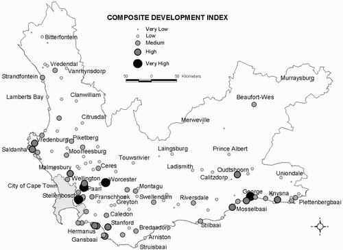
Table 10: Summary of development potential categories
From and it is evident that the majority of Western Cape towns have a predominantly ‘negative’ distribution of development indices. (See Section 2.2 for a definition of ‘negative’ in this context. Negative z-scores are values below the average of the towns in the province. These towns may therefore still grow positively in absolute terms.) With reference to the quantitative development potential of the 131 towns, 79 urban settlements (60 per cent) registered a below average index of ‘Low’ and ‘Very Low’. In contrast, 16 towns were classified as ‘High’ and ‘Very High’ on the quantitative scale.
The spatial distribution patterns of towns according to the development potential index () suggest certain salient trends. Towns with ‘High’ and ‘Very High’ potential are more prevalent near the metropole and along the west and south coasts. The interior of the province is not well endowed with high-potential towns, except for a few ‘Medium’-rated settlements at strategic locations (e.g. Vredendal, Piketberg, Beaufort West, Robertson and Riversdale). On the other hand, ‘Low’ and ‘Very Low’ development potential is concentrated mainly in the Karoo (including the Little Karoo), the west coast interior and the former mission stations.
4. MULTIDIMENSIONAL STRUCTURE OF INDICES
An abstract concept such as development potential cannot be measured directly, but requires an adequate set of empirical indicators to link the concept to observable and measurable characteristics of real world objects (towns). As direct measurement of an abstract concept is impossible, selecting appropriate indicators is no simple matter and not a purely logical exercise. According to Blalock Citation(1969) as quoted by Sullivan & Feldman (Citation1979: 11), ‘… there is a second, often implicit theory that is required to test it’. The function of this ‘auxiliary theory’ is to ‘… specify the relationships between the theoretical and empirical worlds or, more precisely, between abstract concepts and their indicators’ (Sullivan & Feldman, Citation1979: 11).
The ten individual indices were statistically evaluated first to determine whether they were measuring different constructs or not and, secondly, to assess the logical groupings of indices into generalised aggregated composite indices as required by the NSDP.
A correlation matrix of the ten individual indices was computed in order to investigate possible intercorrelations between the various indices. Inspection of the results presented in indicates that with the exception of two indices most are not highly intercorrelated. The exceptions are Institutional and Commercial Services. Both these indices measured the number of commercial and public services present in each town. This result is not unexpected as these two variables are both measures of urban size. This result suggests that the ten individual indices are essentially measuring different dimensions of growth potential without serious overlaps.
Table 11: Correlation matrix of development indices
To complement this analysis and to gain an understanding of how these indices were contributing to the overall composite development index a principal factor analysis (PFA) of the correlation matrix was undertaken (). The results of the PFA with a Varimax Rotation brought additional insights. The dependencies between economic activities as expressed by the Economic Sector and Market Potential indices and Natural Resources Potential are confirmed by their high loadings on the first factor. The second factor confirmed the interrelatedness of the Commercial and Institutional Services indices, whereas the third factor highlighted economic growth performance as measured by the Regional Vitality and Economic Change indices. The fourth factor can be described largely as a Human Resource dimension.
Table 12: Principal factor analysis of development indices
The degree to which the variance of each index has contributed to the overall factor solution is expressed by the multiple R2 value in . The index that is least related to the factor solution is Transport and Communications. The other three indices that are also weakly linked to the factor solution are Human Resource Change, Economic Sectoral Change and Regional Vitality. These are all based on temporal variables, which tends to support the notion that less emphasis should be placed on their contributions to the overall composite development index as they do not seem to fit the pattern.
Table 13: Communalities of principal factor analysis
5. CONCLUSIONS
The aim of this paper was to describe and evaluate the methodology and procedures used by Van der Merwe et al. Citation(2005) to measure and quantify the development potential of all towns in the Western Cape Province. This was achieved by describing how the raw data were transformed into indices and how these were combined into a single composite index. The various indices and the composites were evaluated using, amongst other things, multivariate statistical techniques.
The statistical analysis confirmed that the indices created for measuring urban growth potential were well chosen and constructed with low intercorrelations. This means that they were measuring different dimensions of growth potential with little overlap.
As far as the performance of the various indices is concerned, it was found that those measuring change were quite unstable owing to the use of percentages. Large percentage values were recorded by small places owing to the small base values. In other cases boundary-matching problems between 1991 and 2001 may also have been responsible for these large differences. Another issue to be reconsidered was whether it was wise to assign district level data to all towns in the district. This afforded the smaller centres an equal opportunity to perform against the bigger centres, but it could also elevate their developmental potential levels somewhat. The effect this may have on the results is considered negligible given that these variables make up only a small proportion of the 64 variables used. However, the multidimensional evaluation of the indices did suggest that these indices should be used with caution as they do not appear to fit the pattern.
All indices contributed equally to the composite growth potential index. More research is required to evaluate the effect of using different weights for the contributing indices. The PFA results emphasised the need for further investigations into the orthogonality and higher-order groupings of indices into a composite overall index.
The paper concludes that a sound theoretical and methodological base has been laid on which future public investment decisions in rural towns can be based. It showed that the 131 individual town profiles exhibit distinct spatial inequalities on the various development potential indices. Significantly for future development strategies, the centres with a proven development record are of paramount importance as potential ‘growth engine’ nodes for their respective regions. They should be priority targets for infrastructural investment by government (The Presidency, Citation2003) in order to enhance sustainable and balanced economic development throughout the province.
Notes
1Respectively, Professor (retired); Senior Lecturer; and Research Fellow and Professor (retired), Department of Geography and Environmental Studies, University of Stellenbosch, South Africa.
2Polygons are spatial units (irregularly shaped areas) used in building a GIS database.
REFERENCES
- Blalock , H M . 1969 . Multiple indicators and the causal approach to measurement error . American Journal of Sociology , 75 : 264 – 72 .
- Brutzkus , E . 1975 . Centralised versus decentralised pattern of urbanisation in developing countries: An attempt to elucidate a guideline principle . Economic Development and Cultural Change , 23 : 633 – 52 .
- Deloitte & Touche . 1995 . Wes-Kaap Hinterlandontwikkeling – Op pad na plattelandse groei en ontwikkeling: ‘n Strategiese Raamwerk , Cape Town : Wes-Kaap Hinterlandontwikkelingsprojek .
- Eloff , P J . 1979 . Sentraleplekverval in die sentraal- en westelike Karoo , Universiteit van Stellenbosch : Instituut vir Kartografiese Analise .
- ESCAP (Economic and Social Commission for Asia and Pacific) . 1979 . Guidelines for Rural Centres Planning , New York : United Nations .
- Evans , H E . 1992 . A virtuous circle model of rural-urban development: Evidence from a Kenyan small town and its hinterland . Journal of Development , 28 : 640 – 67 .
- Ferreira , S LA . 1992 . Ruimtelike analise van die distrikekonomie van Warmbad (Transvaal) , Pretoria : Universiteit van Suid-Afrika . D.Litt. et Phil
- Gaile , G L . 1992 . Improving rural–urban linkages through small-town market based development . Third World Planning Review , 14 : 131 – 48 .
- Hardoy , J E and Satterthwaite , D . 1986 . Small and Intermediate Urban Centres: their role in regional and national development in the Third World , Edited by: Hardoy , J E and Satterthwaite , D . London : Hodder & Stoughton .
- Johnson , E AJ . 1970 . The Organization of Space in Developing Countries , Cambridge Mass : Harvard University Press .
- Knesl , J . 1982 . Town and country in development from below: The emerging paradigm for the decade . Ekistics , 49 : 14 – 21 .
- Meissner , F . 1981 . Growth without migration: Towards a model for integrated regional/rural development planning . Ekistics , 48 : 442 – 6 .
- Rondinelli , D A . 1988 . Market town and agriculture in Africa; the role of small urban centers in economic development . African Urban Quarterly , 3 : 3 – 10 .
- Rondinelli , D A . 1991 . Asian urban development policies in the 1990s: From growth control to urban diffusion . World Development , 19 : 791 – 803 .
- Rondinelli , D A , Lombardo , J F and Yeh , G A . 1979 . Dispersed urbanization and population planning in Asia . Ekistics , 277 : 206 – 9 .
- Sullivan , J L and Feldman , S . 1979 . Multiple Indicators: An introduction , Beverly Hills : Sage . Sage University Papers
- The Presidency . 2003 . National Spatial Development Perspective (NSDP) , Pretoria : Policy Co-ordination and Advisory Services .
- Van Der Merwe , I J . 1982 . Die klein dorp in verval . Contree , 12 : 15 – 22 .
- Van Der Merwe , I J . 1983 . Die Stad en sy Omgewing , Stellenbosch : Universiteit-Uitgewers .
- Van Der Merwe , I J , Zietsman , H L , Ferreira , S LA and Swart , G P . 2005 . Growth potential of towns in the Western Cape , University of Stellenbosch . Publication No. 2005/1, Centre for Geographical Analysis