Abstract
Scenario planning has gained prominence among conservationists and policy-makers as a tool for planning, forecasting and learning about the future. This paper explores how participatory scenario planning was applied as a tool for promoting stakeholder engagement on discussions of desired livelihood futures. The study was conducted in Sengwe Communal lands, an area that falls within the Great Limpopo Transfrontier Conservation Area (GLTFCA). Data collection was based on semi-structured interviews, document reviews, focus group discussions and scenario workshops. Future desirable livelihoods that emerged include tourism enterprise development, small-scale irrigation, wildlife and livestock improvement, and energy generation. Development options imagined by locals are inseparable from contemporary politics of transfrontier conservation area governance requiring researchers to shift roles from being catalysts and knowledge brokers to facilitators of learning and negotiation. This paper contributes to contemporary debates on novel approaches to promote engagement with communities for improving biodiversity conservation and livelihoods in emerging transfrontier conservation areas.
1. Introduction
Several countries in southern African are promoting transfrontier conservation to achieve biodiversity conservation, peace and socio-economic empowerment of communities living in and adjacent to protected areas (Hanks, Citation2003). The Peace Parks Foundation has been particularly instrumental in spearheading the formation and signing of transboundary conservation agreements (Peace Parks Foundation, Citation2006). The Great Limpopo Transfrontier Park (GLTP) and Great Limpopo Transfrontier Conservation Area (GLTFCA) have attracted much political, media and academic interest over the years. Established in 2002, the GLTP straddles the borders of Mozambique, South Africa and Zimbabwe and joins the Kruger, Limpopo and Gonarezhou National Parks to cover an area of 35 000 km2. An even larger initiative, the GLTFCA is set combine the core park area of the GLTP and several smaller conservation areas, private game reserves, conservancies and communal areas. Although its actual boundaries are not yet officially defined, it is set to cover approximately 100 000 km2 when fully implemented (Wolmer, Citation2003; Peace Parks Foundation, Citation2006). Tourism is promoted as the flagship for rural development, especially through infrastructure investments (lodges, tour guide services) and providing local people income opportunities through cultural villages, selling crafts and working in businesses such as lodges and restaurants (Joint Management Plan Working Group, Citation2001; Spenceley, Citation2006). It is often implied that communities living in and adjacent to protected areas will derive benefits and participate in their management as key sub-state entities (Wolmer, Citation2003). Governments and donors claim that transfrontier conservation initiatives unite communities historically separated by artificial political boundaries (Hanks, Citation2003; Peace Parks Foundation, Citation2006; Ramutsindela, Citation2007).
However, the implementation history of the GLTP has largely been characterised by a cursory reference to communities with planning essentially remaining technocratic and top-down. Limited attention was paid to the aspirations of communities in Zimbabwe, South Africa and Mozambique (Magome & Murombedzi, Citation2003; Spierenburg et al., Citation2006). In Zimbabwe, community consultations were held for the demarcation of the of the Sengwe–Tshipise Corridor (CESVI, Citation2002) that provides a physical link between Kruger and Gonarezhou National Parks, while in Mozambique the process resulted in induced displacement decision-making in Limpopo Park (Milgroom & Spierenburg, Citation2008; Dear & McCool, Citation2010; Lunstrum, Citation2010). The institutional structures created for ensuring local buy-in not only failed to engender meaningful local influence but also fed into existing power relationships and entrenched inequalities rather than challenged them (Wolmer, Citation2003; Büscher & Schoon, Citation2009). Other authors have levelled criticism on the dominance of the South Africa state in the process of spearheading the implementation of the GLTP with most donors and infuential organisations such as the Peace Parks Foundation based there (Wolmer, Citation2003; van Amerom & Büscher, Citation2005; Ramutsindela, Citation2007). Katerere et al. (Citation2001) caution that benefits of participation achieved under community-based natural resource management are likely to be lost in transfrontier conservation initiatives given failure to engage locals in protected area decision-making processes. There are limited studies that explore forward-looking approaches through which hitherto marginalised communities and their allies can turn such policy shifts to their advantage.
This paper shows how scenario planning was used as a tool to promote stakeholder engagement in desired livelihood futures for communities within the GLTFCA. It also seeks to show that imagined livelihood futures within the GLTFCA are inseparable from contemporary politics on conservation and benefit sharing. The study was conducted as part of a regional project whose objective was to enhance the ability of communities living within the GLTFCA (in Mozambique, South Africa and Zimbabwe) to devise, implement and adapt their natural resource management regimes and to develop approaches and strategies for maximising both biodiversity conservation and livelihoods. The rest of the paper is structured as follows. The next section briefly reviews literature on scenario planning and discusses its relevance in the context of the GLTFCA. This is followed by a description of the study area and research methods. The paper then presents findings based on implementing scenario planning and gives a summary of preferred livelihood futures. This is followed by a discussion of the results focussing on the process, a reflection on the approach followed and a discussion about the roles of researchers. The last section presents the conclusion.
2. Scenario planning and livelihoods in the GLTFCA
Scenario planning is increasingly recognised as a tool for planning when the future is unknown or uncertain (Peterson et al., Citation2003b). Scenario planning has been adopted in several fields ranging from conservation and wildlife management (Neff, Citation2007), agriculture (deGrassi, Citation2007) to climate change (Moss et al., Citation2010). Scenarios are internally consistent and realistic narratives of how the future might unfold based on a coherent set of assumptions about existing conditions and processes while also factoring in future potential drivers of development (Carpenter et al., Citation2005; Raskin, Citation2005). In the natural resource management literature, scenario development is presented as a key methodology to accommodate different stakeholder interests, as well as harmonise socio-economic, environmental and conservation goals (Kok et al., Citation2007). Scenario planning involves crafting scenario logics that represent plausible futures of what could happen under particular assumptions and conditions. Contrasting different scenarios informs thinking about the relationships between choices, dynamics and alternative futures, thus improving decision-making (Varum & Melo, Citation2010). Wright & Goodwin (Citation2009) note that the construction of scenarios relies on praxis-oriented frameworks that rationalise and challenge existing mental frames, minimise surprises and broaden participants’ thinking and reactions on different possibilities.
Globally, the network of transboundary protected areas has increased significantly (Lysenko et al., Citation2007). This expansion is occurring amid calls for widening opportunities for indigenous populations affected by conservation to reduce antagonism towards protected areas (Brandon et al., Citation1998; Stern, Citation2008). Brockington et al. (Citation2006) maintain that planners and conservations are increasingly faced with the challenge of reconciling past mistakes and promoting inclusive conservation that does not further disenfranchise these populations. Thus, following the 5th World Parks Congress held in South Africa in 2003 on ‘Benefits beyond Boundaries’, most countries have embraced innovative ways to improve protected areas management (Bushell et al., Citation2007). As transfrontier conservation areas continue to be implemented, the need to promote pro-people approaches to conservation is emphasised while cautioning against inflexible prescriptions and decision-making without community support. Conservation organisations and scientists are increasingly called to investigate approaches that achieve conservation in a more ethical and conservation-friendly manner (Agrawal & Redford, Citation2009). One notable approach, participatory scenario planning was specifically developed as a research agenda to improve local livelihoods in the GLTFCA (Murphree, Citation2004). Local-level participatory scenario planning was meant to engage decision-makers and communities to play an active role in designing natural resource regimes that enhance biodiversity conservation and improve livelihoods in the long term.
3. Study area and methods
3.1 Description of the study area
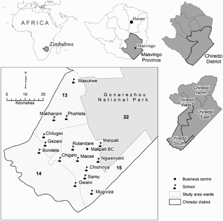
The study area falls under Sengwe Communal lands located in Chiredzi district in south-east Zimbabwe. For local government administrative purposes, communal lands are divided into administrative and management units called wards. The study was conducted in three wards, namely Pahlela (Ward 13), Sengwe (Ward 14) and Malipati (Ward 15). From these three wards, six sites were purposively selected, which include Pahlela and Masukwe (Ward 13), Gwaivi (Ward 14), Muhlekwani/Ngwenyeni, Chishinya and Maose (Ward 15) (see ). We considered accessibility, distance from the Gonarezhou National Park and socio-ethnic background when selecting the study sites. Each site was comprised of a cluster of four to six villages. In terms of ethnicity, the Shangaan are the dominant group and claim to be the original inhabitants of the area. Mugiviza and Chishinya are inhabited by Ndebele people who migrated from Filabusi during the forced relocations conducted by the colonial government in the 1950s. Muhlekwani, Pahlela and Masukwe are inhabited by Shangaan-speaking and Karanga-speaking people who migrated from south-central Zimbabwe. Pahlela, Muhlekwani and Masukwe lie close to the Gonarezhou National Park while Chishinya and Gwaivi are approximately 25 km from the park. Murungweni et al. (Citation2011) observed that there is marked livelihoods diversity, with a majority of households cattle based, crop based and with off-farm income. Dry-land cropping is limited to drought-resistant crops such as sorghum and millet. Local people living close to the Gonarezhou National Park harvest wood, timber, fruits and other resources from the park (Mutenje et al., Citation2010).
Figure 1: Location of the study area
3.2 Research methods
A qualitative case-study approach was adopted for this research (see Stake, Citation1995). A case-study approach was used because it is useful in exploring a real-life phenomenon while building upon or strengthening existing knowledge (Yin, Citation2009). A case study provided a better approach to exploring communities’ lived-in experiences and ensured scenario planning tools would improve practice, for such an understanding can have influence on policy and practice (Ritchie & Spencer, Citation2002). A case study is also suitable for research characterised by process-tracing (George & Bennett, Citation2004) and involves multiple methods such as interviews, observations and document analysis (Denzin & Lincoln, Citation2005). Between 2007 and 2012 data were gathered using semi-structured interviews, focus group discussions, scenario workshops and document analysis. Archival, published and unpublished data relating to the Gonarezhou National Park and GLTP processes were reviewed. Mills et al. (Citation2008) observe that non-technical literature is a source of empirical data and provides a context for researchers.
Semi-structured interviews were conducted with government and non-government organisation officials. Formal and informal and conveniently were held with district planners, park rangers and community leaders (such as business people, councillors, village heads, headmen, chiefs and representatives of development committees, e.g. Malipati Irrigation Scheme, Sengwe Vamanani Crafts Association (SEVACA), Malipati Development Trust). Traditional leaders and councillors at the case-study sites were also interviewed for their insights into the development of the transfrontier conservation area, particularly the place of the Sengwe–Tshipise Corridor in the livelihoods of Sengwe residents. In total, 17 semi-structured interviews and nine focus group discussions were conducted.
3.3 Scenario planning workshops
In the literature there are several approaches to scenario planning. Our approach was based on scenario planning guidelines and insights from other participatory approaches (Evans et al., Citation2006). We followed how scenario planning was adopted in conservation planning (Peterson et al., Citation2003a) and the way local communities can be engaged in park management (Daconto & Sherpa, Citation2010). Our study focused on identifying principal elements of scenario planning, which include: definition and purpose of the scenarios; gathering information about current and future driving forces, main factors that influence the change described; selecting a base year; time horizon and time steps; storylines – a narrative description that highlights the scenario main features, including its relationship with driving forces; description of step-wise changes in the future of society and the environment; and exploring implications for decision-makers (Rotmans et al., Citation2000; Wollenberg et al., Citation2000). We adopted both the principal elements and common characteristics of scenarios when conducting scenario workshops in the six study sites. In addition, insights from multi-scale scenario planning approaches were adapted so as to explore and discuss key issues affecting different scales, although our focus remained at the local scale (Kok et al., Citation2007).
Six research assistants (also referred to as community-based facilitators) were recruited and trained in undertaking the scenario planning exercises using set guidelines and techniques. Participants for workshops were purposively selected, and where possible effort was made to balance in terms of age, ethnicity, gender, education and leadership position in community. In total, there were six core working groups at each of the study sites (Masukwe, Pahlela, Maose, Chishinya, Muhlekwani and Gwaivi). These core working groups included men and women who met voluntarily. In addition to being present at some of the 37 scenario planning workshops facilitated by community-based facilitators, we convened six ward-level scenario planning sessions where results from core group meetings were presented as feedback to communities. The purpose of these workshops was to ensure that the wider community and its leadership could consider collectively the possible futures for Sengwe. It was also an opportunity where different community visions were synthesised.
Finally, a stakeholder workshop was held between communities and district-level planning officials. In total, 34 people participated: 24 participants from the six working groups, one councillor, one headman, two local District Council representatives, one representative from local government ministry and chairman of the Combination Management Authority, three non-governmental organisations representatives working on food relief, and one representative from a non-governmental organisation working on transfrontier conservation. Workshops were flexible and included question-and-answer sessions. The final results of this process and lessons were orally presented at a council technical planning meeting in Chiredzi. Paper copies of the scenario planning reports were submitted to council and some copies were kept by core working group members and community leaders.
4. Results
4.1 Characterisation of key future drivers
In various workshops during the ‘driver identification phase’ participants from each site jointly identified and listed key current and future drivers. In terms of the future, local communities across the study sites could identify the major drivers that would influence lifestyles and livelihoods in the next 25 to 30 years, keeping in mind some of the likely policy options surrounding the GLTP and GLTFCA. In various workshops, participants could describe and explain the drivers, and how and why they would affect local livelihoods and lifestyles. Drivers were clustered into socio-political, economic, ecological, and technological domains. Drivers were synthesised and presented at a feedback workshop held at Malipati Business Centre, attended by scenario planning working group members from all six sites, traditional leaders and business people. presents the major drivers, ranked by communities in order of importance.
Table 1: Ranking of future driving forces
Drivers are an expression of past challenges of living in the area and the fears over whether these would persist in the future. The drivers also provided an expression of what participants lacked and pointed to desirable development pathways. Participants demonstrated an awareness and understanding of the complexity of conservation and political issues driving the GLTFCA and how these subsequently would affect choices they would make for their livelihoods in the future. Political unrest and general economic collapse in Zimbabwe were highlighted as key factors that constrain communities. Historically apartheid in South Africa and the civil war in Mozambique restricted people's mobility, especially for the elderly, and thus limited livelihood options. Until recently, Zimbabwe's political uncertainty and severe economic crisis presented as a major threat to livelihoods. For instance, communities decried the poor financial performance of the Communal Areas Management Programme for Indigenous Resources (CAMPFIRE) over the past five years (2003–08) due to a high inflation. For instance, one local narrated his experience with CAMPPFIRE:
From 2004 to 2008 … but especially in 2007 and 2008, Chiredzi [RDC] did not give us any money from CAMPFIRE. This was due to inflation during the economic turndown and ever changing exchange rates which made income meaningless. But now … we are receiving our money direct from [the] safari operator.
4.2 Synthesis of scenario narratives proposed by communities
Drawing insights from Enfors et al. (Citation2008), our emphasis was on exploring a plausible scenario outlook for Sengwe, described in qualitative terms based on agro-ecological conditions, desired livelihood pursuits and lifestyles around the year 2030. Participants crafted with possible development projects and strategies for realising desired livelihood futures. The following scenario storylines each represent different concerns and voices of participants from Sengwe Communal lands regarding the current livelihoods, the future of agriculture, tourism enterprises and the potential of energy generation. Interview excerpts are used to illustrate these three future livelihood scenarios.
4.2.1 Scenario 1: Default scenario
In the default scenario, participants argued that they value their current way of life. The comments in Box 1 summarise the expressions of participants at the workshops and some of the challenges currently faced by the community.
Transport infrastructure and communication
Our roads are poor. The buses charge us R100 [about of US$10] for a one-way trip to Chiredzi. We rely on MTN [a South African service provider] to make phone calls. There is no local telecommunications provider in here.
Wildlife management
Money is coming but we do not know how much. Last time they [CAMPFIRE committee] told us each school was to receive money but they did not tell us how much.
Irrigation and livelihoods
We cannot cultivate our plots throughout the year because there is not enough water. Water is a problem; we need water to grow more. The extension officers are very particular on crops grown here, but there is no market. We just dry all our vegetables and eat with the household. Beitbridge and Chiredzi are far away, it's expensive to transport cabbages by bus.
Funding is a problem. Malipati [irrigation scheme] cannot support more farmers because of the general collapse of the economy
Source: Fieldwork notes
Although this situation is untenable, participants imagined and felt that this was desirable. Further interviews and focus group discussions showed that locals were hesitant to talk about other possibilities due to fears of relocation, with some arguing ‘we will be moved to Rutenga’, which is located about 100 km away. Despite highlighting the role of wildlife revenue to community development, participants claimed they had no information on revenue streams from CAMPFIRE. For instance, when communities called for more transparency on income during one ward-level scenario planning workshop, one participant openly cautioned us ‘to concentrate on scenario planning and not to talk about CAMPFIRE’. Further investigations showed that ranchers and CAMPFIRE committee members often benefited through cash or in-kind donations from safari operators at the expense of the community. Communities felt that wildlife was a key resource that could contribute to photographic tourism and hunting revenue, especially when properly managed.
The following scenarios, characterised by agricultural and tourism investments, were argued to epitomise a ‘New Jerusalem’ when all the major problems facing communities are addressed. These narratives were part of a series of discussions in which communities described the lives they imagined would enhance their livelihoods when the GLTFCA is fully implemented.
4.2.2 Scenario 2: ‘Agricultural boom’
There is a huge investment in irrigation infrastructure and farming technologies. By 2030, all three wards have each a functioning irrigation scheme. Most households own plots on the schemes and complement dry-land cropping. Fields are left fallow and habitat for wildlife and pastures for livestock increases and improves. Electricity is mainly used for pumping water on the irrigation schemes and on grazing schemes. National Park rangers establish satellite stations in Sengwe area for problem animal control. Credit for inputs and agricultural equipment are made available by the government and donors. Marketing of livestock improves with the establishment of Sengwe Cattle Producers Association.
4.2.3 Scenario 3: ‘Tourism boom’
Major tourism infrastructure is completed by 2020. The tourist bridge linking Zimbabwe and South Africa is fully operational. Locals own tourist chalets and guest houses at prime locations. Shangaan culture is a major attraction drawing tourists to the Shangaan Cultural village. Cultural tours are promoted and flourish due to marketing efforts by tour operators and other players in the tourism industry, with the draw card being the increased wildlife numbers. Tour operators in Zimbabwe and South Africa offer many visitors an opportunity to visit multiple destinations in the GLTFCA. Locals engage in selling and marketing of artefacts made from ilala. Locals become employed in tourism and support services. Look and learn visits and cultural exchange programmes occur with neighbouring countries.
There was consensus among most participants that the ‘boom’ in both agriculture and tourism would significantly improve their livelihoods in the future. Most participants felt that by intensifying cropping in small-scale irrigation, they will meet local cereal demand and supply the increasing visitors in the area brought by tourism. Building on earlier ward workshops, desirable end-points were explored and discussed based on key drivers and expected opportunities in the GLTFCA. After debating these scenarios, participants crafted key development proposals for improving livelihoods under each scenario narrative. The following section summarises potential development pathways and strategies that were synthesised at a workshop held at Alvord Training Institute, situated about 40 km from Masvingo town.
4.3 Livelihood development pathways
For the future, participants are inspired in what they see as important to retain and achieve (visions, dreams and aspirations). The key development pathways centred on tourism enterprise development, water and irrigation development and energy/power generation. shows the location of sites for key livelihood development projects. summarises the specific strategies recommended for meeting desired futures based on community visions.
Table 2: Location of sites for key livelihood development projects
Table 3: Specific strategies recommended for meeting desired futures
From these strategies, participants identified and explored policy actions, trends and key events that acted as a baseline for designing strategies for achieving desired livelihoods. Apart from appreciating what the future holds, we wanted participants to discuss concrete strategies that they could use to overcome institutional or other challenges and take advantage of opportunities in the GLTFCA. Discussions were complemented by suggesting short-term policy directions and encouraging participants to conduct a Strengths, Weaknesses, Opportunities and Threats (SWOT) analysis. At the end of the writing workshop, key desired livelihood futures were refined and consolidated. Participants value the importance of improving livestock production and wildlife management practices. Despite a history marred by displacement and marginalisation, participants in these communities go beyond internal divisions and couch a collective vision that is driven by the need to harness all possible opportunities that come with the implementation of the GLTFCA. From interviews it was evident that the scenario planning process helped shape participants imaginations about their area and the future of conservation (Box 2).
At first people tended to focus on individual projects but, this changed to community projects and a lot of people learned how by agreeing on future projects, it is possible to achieve better lives in the GLTFCA.
We now can use scenario methods in almost every aspect of our lives, from planning for schools to dip-tanks. Although the techniques did not appear easy to use, we later mastered them and now they are easy to use and will help for planning development projects for Sengwe people.
The GLTP should benefit locals first. We do not want outsiders to get employment. It should be locals first. The project proposals we developed can help improve our well being and livelihoods. We need to be given opportunities to benefit from economic opportunities which will come with increased tourist traffic between Kruger and Gonarezhou National Parks.
We never thought about tomorrow. We did not want to plan because at first we thought we would be relocated … Scenario planning helped us understand what might happen in future and especially to begin to plan for our children, we will not be moved.
We now want to be part of it. We want to have some lodges it the Park [Gonarezhou]. We can have partnerships like the Mahenye [ … ]. The bottom line is we have to be part of development otherwise everything cannot just go to outsiders.
You [Research team] helped us; we never thought this thing was also for us. Now scenario planning has made this clear, we will plan and we will not be moved. We want to have community managed safari hunting activities. We cannot just leave it to the [Chiredzi Rural District] Council.
When the corridor and air strip are fully implemented it will improve access to the area with safari hunting, wildlife-based tourism, Shangaan culture, sale of crafts and sale of farm produce from irrigation to tourist lodges. We can then access Bende Mutale [in South Africa] easily without going to Beitbridge Border Post.
Source: Fieldwork notes
At the beginning of the research, most participants expressed resentment towards the Transfrontier Park, but later in the process it was increasingly seen as a source of opportunities.
5. Discussion
Scenario planning proved to be a potentially useful tool for engaging local community representatives and district planning officials. Stakeholder engagement processes linked community participants and planners to reflect on the opportunities and challenges presented by the GLTFCA. This was made possible with the facilitation by external researchers. Judging from perspectives presented by participants during focus groups, interviews and scenario planning workshops, local people are faced with numerous inhibitions as decisions on creating transfrontier areas presents both opportunities and challenges. In the following sections, we reflect on the scenario planning process highlighting what this means for development of livelihoods and the roles of researchers in these processes.
5.1 Key future drivers and livelihood development pathways
Current and future drivers that influence livelihoods are complex and multi-faceted. During the driver identification phase, it became apparent that discussions were not supposed to be curtailed because they reveal local people's knowledge. This reduced uncertainty in developing strategies for achieving the desired livelihood pathways. From an abstract level, local and district-level stakeholders appreciated the complexity of future drivers for the GLTFCA as a socio-ecological system. As scenario planning working groups emerged naturally in each ward, this represents collective action and organisational capacity at a local level in which local priorities and objectives, as well as the extra-local ones, are set through systematic multiparty interaction. Such deliberative processes are crucial in dealing with not only multiple and conflicting objectives but also competing understandings of the human–ecosystem interactions within the GLTFCA. The long-term sustainability of transfrontier conservations will depend on blending different types of land use and will emphasise those that improve local livelihoods. Community-based tourism enterprises, small-scale irrigation, wildlife and livestock improvement programmes can all be part of a rich mix of options that could be established to improve livelihoods within the GLTFCA. As Chitakira et al. (Citation2012) note, transfrontier conservation areas provide unique opportunities for strategies that combine agriculture with biodiversity conservation. No blueprint exists for the ideal combination of land use options. In the short term, reviving small-scale irrigations and livestock management programmes can contribute to improving livelihoods. This can be coupled with tourism enterprises in the long term.
The development of tourism is fraught with challenges. The place of tourism in development is captured by Ferreira (2004:303), who maintains that it is ‘the salvation for Africa's economic woes, poverty and underdevelopment’. Ferreira (Citation2004) argues that Zimbabwe's unstable political situation negatively affected wildlife conservation and tourism for Gonarezhou National Park. Despite this, participants interviewed remained optimistic that they can still contribute to tourism planning and development in the long term. Participants interviewed argued for ‘local’ ownership of tourism lodges, especially through joint ventures. A review of the Integrated Tourism and Business Development plan specifies the need to holistically plan for tourism in the GLTP. Although local involvement is called for, official discourse appears to emphasise private-sector investment. Even though most participants felt that ‘this is our time’, official planning policies are driven more by what works.
In this area, tourism planners face a dilemma in planning how to complement nature-based tourism with cultural tourism (Mkono, Citation2010), which the locals seem to highly position. Hampton (Citation2005) argues that a systematic approach to achieving tourism economic benefits should consider local communities in the decision-making regarding the type and scale of development. In the case of Sengwe, conditions for enabling full ownership and control of tourism enterprises, especially those that centre on cultural heritage, need to be enabled. Although this is desirable, this is often hampered by operational, structural and cultural limitations (Tosun, Citation2000, Citation2006; Manwa, Citation2007). Even in situations where communities own tourist lodges, their revenue potential has to be evaluated in terms of tourists' willingness to pay for tourism outside protected areas (Chaminuka et al., Citation2012). Tourists consider political, personal safety and health risks when choosing host destinations and services.
5.2 Role of external researchers
Researchers play different roles to guide stakeholders in dealing with potential problems and alternative development pathways. Ward et al. (Citation2010) observe that researchers assume knowledge-brokering functions and their activities often trigger learning and improve the scope of negotiations. As researchers with experience in conducting applied socio-economic research on natural resource use in communal areas, we valued responsiveness to changing contexts and sought to enhance communities' capacities to innovate and take advantage of opportunities that come with the implementation of the GLTFCA. Even though this research did not prescribe solutions, the scenario planning workshops provided a platform for discussing the problems and challenges for livelihoods in the future. By adopting and maintaining a reflexive approach, we could link local and broader transfrontier policy realities and possible development options. Participants proposed key future livelihood options and development pathways based on their understanding of likely opportunities. Different livelihood development pathways were presented at district level, with the research team providing a ‘bridging link’ for bringing stakeholders into dialogue. As a bridging organisation, we helped in trust-building, knowledge generation, collaborative learning and preferences elicitation among actors that were key components in stakeholder negotiations. In the literature, these roles are performed by ‘boundary spanners’ who are defined as individuals who connect groups, centres and levels and play a central role in the emergence, organisation and functioning of networks (Roberts & King, Citation1996; Williams, Citation2010).
External facilitators are increasingly seen as important for linking various stakeholders and promoting inclusion of stakeholder preferences in debates on different policies. Working with existing institutions such as the Sengwe Tshipise Wilderness Combination Management Authority provided an avenue for discussing some of the plausible futures and establishing collective consensus on the possible development pathways. The long-term viability of this area vis-à-vis the GLTP and its possible future evolutions can only be assured through building capacity of these key actors and others institutions central for the implementation of the GLTFCA. Murphree (Citation2004) argues that professional science should be put at the service of communities where the former is less intrusive and civil science is less marginal. By assuming a brokering and facilitator role, we helped participants to take their proposals from scenario planning exercises to the district technical planning meeting where they were adopted and endorsed. A majority of Sengwe residents now recognise that future decisions on resources access and use in the Sengwe–Tshipise Corridor will be mediated by various technical and institutional arrangements such as border security, wildlife corridors and disease control, among other factors.
6. Conclusion
This study set out to determine the potential of participatory scenario planning with selected communities to plan for future livelihood options in the context of an unfolding conservation initiative, the GLTFCA. The paper has presented a highly positive outlook on the application of scenario planning techniques with participants in Sengwe Communal Lands. The use of visual learning tools (e.g. charts, diagrams and maps) for illustrating different scenarios improved participants' debates about strategies for achieving the plausible livelihood futures. Despite its complexity, scenario planning can be structured and applied to the community level but needs to be localised in order to be ‘real’, understandable, and meaningful to participants. External facilitators can play a key role in promoting stakeholders' engagement through a structured but flexible approach to scenario planning. However, scenario building is not a discrete one-off process but an important diagnostic and research tool for initiating stakeholder engagement to achieve shared meanings and mutually desirable change. Visioning exercises open up stakeholders' mental frames and combine different sources of knowledge to promote social learning. When systematically executed, the scenario planning process is a powerful tool for learning and consensus-building, making participants better at preparing for, adapting to and shaping their future in uncertain and complex environments (Wollenberg et al., Citation2000; Peterson et al., Citation2003a).
Adapting scenario planning to the context ensures that the process itself does not result in outputs that are ‘excessively conjectural, hypothetical, tangential, non germane and unrealistic’ (Molitor, Citation2009:88). However, to be effective, both the scenario planning process and potential development pathways must not be disconnected from realities and complexities of the policy arena surrounding transfrontier conservation area. The process has to be moderated using local leaders and facilitators to keep it in check. Participants' imaginations of the future livelihood options (based on needs, visions and aspirations) are inseparable from contemporary politics and clash with higher-level planning ideas. Adopting the use of scenario planning in emerging transfrontier conservation areas can facilitate the development of creative forums for stakeholders to discuss and determine solutions to some of the livelihood challenges in these areas. Participatory scenario planning can be used as part of a broader suite of approaches where communities are empowered to explore the future.
Acknowledgements
This research was funded by the International Development Research Centre (IDRC) under the Local-level Scenario Planning, Iterative Assessment and Adaptive Management Project (Grant number 103275-001). Fieldwork costs for Chaka Chirozva were also supported by the AHEAD-GLTFCA Seed Grants Programme and the International Foundation for Science (Grant number S/5157-1). We wish to thank the two anonymous reviewers for their comments.
References
- Agrawal, A & Redford, K, 2009. Conservation and displacement: An overview. Conservation and Society 7(1), 1–10. doi: 10.4103/0972-4923.54790
- Brandon, K, Redford, KH & Sanderson, S, 1998. Parks in Peril: People, Politics, and Protected Areas. Island Press, Washington, DC.
- Brockington, D, Igoe, J & Schmidt-Soltau, K, 2006. Conservation, human rights, and poverty reduction. Conservation Biology 20(1), 250–2. doi: 10.1111/j.1523-1739.2006.00335.x
- Büscher, B & Schoon, M, 2009. Competition over conservation: Collective action and negotiating transfrontier conservation in southern Africa. Journal of International Wildlife Law and Policy 12(2), 1–27.
- Bushell, R, Staiff, R & Eagles, PF, 2007. Tourism and Protected Areas: Benefits Beyond Boundaries. CABI, Wallingford.
- Carpenter, SR, Pingali, PL, Bennett, E & Zurek, M, 14;. Ecosystems and Human Well-being: Scenarios. Millennium Ecosystem Assessment. Island Press, Washington, DC.
- CESVI., 2002. The Sengwe Corridor Concept Paper. Report to Department of Parks and Wildlife Management (DNPWM) and Beitbridge and Chiredzi Rural District Councils, CESVI [Cooperazione e Sviluppo], Harare.
- Chaminuka, P, Groeneveld, R, Selomane, A & van Ierland, E, 2012. Tourist preferences for ecotourism in rural communities adjacent to Kruger National Park: A choice experiment approach. Tourism Management 33(1), 168–76. doi: 10.1016/j.tourman.2011.02.016
- Chitakira, M, Torquebiau, E & Ferguson, W, 2012. Unique combinations of stakeholders in a transfrontier conservation area promote biodiversity-agriculture integration. Journal of Sustainable Agriculture 36(3), 275–95. doi: 10.1080/10440046.2011.611584
- Daconto, G & Sherpa, LN, 2010. Applying scenario planning to park and tourism management in Sagarmatha National Park, Khumbu, Nepal. Mountain Research and Development 30(2), 103–12. doi: 10.1659/MRD-JOURNAL-D-09-00047.1
- Dear, C & McCool, S, 2010. Causes and Consequences of displacement decision-making in Banhine National Park, Mozambique. Conservation and Society 8(2), 103–11. doi: 10.4103/0972-4923.68910
- deGrassi, A, 2007. Envisioning futures of African agriculture. Progress in Development Studies 7(2), 79–98. doi: 10.1177/146499340600700201
- Denzin, NK & Lincoln, YS, 2005. Introduction: The discipline and practice of qualitative research. In Denzin, NK & Lincoln, YS (Eds.), The Sage Handbook of Qualitative Research. Sage, London, 1–32.
- Enfors, EI, Gordon, LJ, Peterson, GD & Bossio, D. (2008). Making investments in dryland development work: Participatory scenario planning in the Makanya Catchment, Tanzania. Ecology and Society, 13(2), 42. http://www.ecologyandsociety.org/vol13/iss2/art42/ Accessed 22 March 2011.
- Evans, K, Velarde, S, Prieto, R, Rao, S, Sertzen, S, Dávila, K, Cronkleton, P & de Jong, W, 2006. Field Guide to the Future: Four Ways for Communities to Think Ahead. Centre for International Forestry Research (CIFOR), ASB and World Agroforestry Centre, Nairobi.
- Ferreira, S, 2004. Problems associated with tourism development in southern Africa: The case of transfrontier conservation areas. GeoJournal 60(3), 301–10. doi: 10.1023/B:GEJO.0000034736.23918.05
- George, AL & Bennett, A, 2004. Case Studies and Theory Development in the Social Sciences. MIT Press, Cambridge, MA.
- Hampton, MP, 2005. Heritage, local communities and economic development. Annals of Tourism Research 32(3), 735–59. doi: 10.1016/j.annals.2004.10.010
- Hanks, J, 2003. Transfrontier conservation areas (Tfcas) in southern Africa. Journal of Sustainable Forestry 17(1–2), 127–48. doi: 10.1300/J091v17n01_08
- Joint Management Plan Working Group, 2001. Draft Great Limpopo Transfrontier Park Joint Management Plan.
- Katerere, Y, Hill, R & Moyo, S, 2001. A Critique of Transboundary Natural Resources Management (TBNRM) in Southern Africa. International Union for Conservation of Nature and Natural Resources/Regional Office of Southern Africa (IUCN/ROSA), Harare.
- Kok, K, Biggs, R & Zurek, M. (2007). Methods for developing multiscale participatory scenarios: Insights from southern Africa and Europe. Ecology and Society, 13(1), 8. http://www.ecologyandsociety.org/vol12/iss1/art8/ Accessed 22 March 2011.
- Lunstrum, E, 2010. Reconstructing history, grounding claims to space: History, memory, and displacement in the Great Limpopo Transfrontier Park. South African Geographical Journal 92(2), 129–43. doi: 10.1080/03736245.2010.530062
- Lysenko, I, Besançon, C & Savy, C. (2007). 2007 UNEP-WCMC Global List of Transboundary Protected Areas. http://www.tbpa.net/docs/78_Transboundary_PAs_database_2007_WCMC_tbpa.net.pdf Accessed 22 February 2011.
- Magome, H & Murombedzi, J, 2003. Sharing South African National Parks: Community land and conservation in a democratic South Africa. In AdamsWM & MulliganM (Eds.), Decolonizing Nature: Strategies for Conservation in a Post-colonial Era. Earthscan, London, 108–34.
- Manwa, H, 2007. Is Zimbabwe ready to venture into the cultural tourism market? Development Southern Africa 24(3), 465–74. doi: 10.1080/03768350701445558
- Milgroom, J & Spierenburg, M, 2008. Induced volition: Resettlement from the Limpopo National Park, Mozambique. Journal of Contemporary African Studies 26(4), 435–48. doi: 10.1080/02589000802482021
- Mills, J, Bonner, A & Francis, K, 2008. The development of constructivist grounded theory. International Journal of Qualitative Methods 5(1), 25–35.
- Mkono, M, 2010. The future of tourism in Zimbabwe: Towards sustainability? Tourism Analysis 15(3), 387–91. doi: 10.3727/108354210X12801550666349
- Molitor, G, 2009. Scenarios: Worth the effort? Journal of Future Studies 13(3), 75–86.
- Moss, RH, Edmonds, JA, Hibbard, KA, Manning, MR, Rose, SK, van Vuuren, DP, Carter, TR, Emori, S, Kainuma, M, Kram, T, Meehl, GA, Mitchell, JFB, Nakicenovic, N, Riahi, K, Smith, SJ, Stouffer, RJ, Thomson, AM, Weyant, JP & Wilbanks, TJ, 2010. The next generation of scenarios for climate change research and assessment. Nature 463(7282), 747–56. doi: 10.1038/nature08823
- Murphree, MW, 2004. Negotiating the future: Local level scenaro modelling, iterative assessment and adaptive management. WWF SARPO Concept Workshop on Self-Administered Performance Protocols, 4–6 August, Johannesburg.
- Murungweni, C, van Wijk, MT, Andersson, JA, Smaling, EMA & Giller, KE, 2011. Application of fuzzy cognitive mapping in livelihood vulnerability analysis. Ecology and Society, 16(4), 8. http://dx.doi.org/10.5751/ES-04393-160408 Accessed 21 February 2012. doi: 10.5751/ES-04393-160408
- Mutenje, M, Ortmann, G, Ferrer, S & Darroch, M, 2010. Rural livelihood diversity to manage economic shocks: Evidence from south-east Zimbabwe. Agrekon 49(3), 338–57. doi: 10.1080/03031853.2010.503381
- Neff, MW, 2007. Scenario planning for wildlife management: A case study of the National Elk Refuge, Jackson, Wyoming. Human Dimensions of Wildlife 12(4), 219–26. doi: 10.1080/10871200701442783
- Peace Parks Foundation, 2006. Peace Parks Foundation Ten Years Review 1997–2006. Peace Parks Foundation, Stellenbosch.
- Peterson, GD, Beard Jr, TD, Beisner, BE, Bennett, EM, Carpenter, SR, Cumming, GS, Dent, CL & Havlicek, TD, 2003a. Assessing future ecosystem services: A case study of the Northern Highlands Lake District, Wisconsin. Conservation Ecology 7(3), 1. http://www.consecol.org/vol7/iss3/art1 Accessed 17 June 2011.
- Peterson, GD, Cumming, GS & Carpenter, SR, 2003b. Scenario planning: A tool for conservation in an uncertain world. Conservation Biology 17(2), 358–66. doi: 10.1046/j.1523-1739.2003.01491.x
- Ramutsindela, M, 2007. Transfrontier Conservation in Africa: At the Confluence of Capital, Politics and Nature. CABI, Wallingford.
- Raskin, P, 2005. Global scenarios: Background review for the Millennium Ecosystem Assessment. Ecosystems 8(2), 133–42. doi: 10.1007/s10021-004-0074-2
- Ritchie, J & Spencer, L, 2002. Qualitative data analysis for applied policy research. In Bryman, A & Burgess, RG (Eds.), Analysing Qualitative Data. Routledge, London, 173–94.
- Roberts, NC & King, PJ, 1996. Transforming Public Policy: Dynamics of Policy Entrepreneurship and Innovation. Jossey-Bass, San Francisco.
- Rotmans, J, van Asselt, M, Anastasi, C, Greeuw, S, Mellors, J, Peters, S, Rothman, D & Rijkens, N, 2000. Visions for a sustainable Europe. Futures 32(9/10), 809–31. doi: 10.1016/S0016-3287(00)00033-1
- Spenceley, A, 2006. Tourism in the Great Limpopo Transfrontier Park. Development Southern Africa 23(5), 649–67. doi: 10.1080/03768350601021897
- Spierenburg, M, Steenkamp, C & Wels, H, 2006. Resistance of local communities against marginalization in the Great Limpopo Transfrontier Conservation Area. Focaal (47), 18–31. doi: 10.3167/092012906780646479
- Stake, RE, 1995. The Art of Case Study Research. Sage, Thousand Oaks, CA.
- Stern, MJ, 2008. The power of trust: Toward a theory of local opposition to neighboring protected areas. Society and Natural Resources 21(10), 859–75. doi: 10.1080/08941920801973763
- Tosun, C, 2000. Limits to community participation in the tourism development process in developing countries. Tourism Management 21(6), 613–33. doi: 10.1016/S0261-5177(00)00009-1
- Tosun, C, 2006. Expected nature of community participation in tourism development. Tourism Management 27(3), 493–504. doi: 10.1016/j.tourman.2004.12.004
- van Amerom, M & Büscher, B, 2005. Peace parks in southern Africa: Bringers of an African renaissance? Journal of Modern African Studies 43(2), 159–82. doi: 10.1017/S0022278X05000790
- Varum, CA & Melo, C, 2010. Directions in scenario planning literature – A review of the past decades. Futures 42(4), 355–69. doi: 10.1016/j.futures.2009.11.021
- Ward, V, Smith, S, Foy, R, House, A & Hamer, S, 2010. Planning for knowledge translation: A researcher's guide. Evidence & Policy: A Journal of Research, Debate and Practice 6(4), 527–41. doi: 10.1332/174426410X535882
- Williams, P, 2010. Special agents: The nature and role of boundary spanners. Presentation at the ESRC Seminar Series on Collaborative Futures: New Insights from Intra and Inter-Sectoral Collaborations, University of Birmingham, February 2010.
- Wollenberg, E, Edmunds, D & Buck, L, 2000. Using scenarios to make decisions about the future: Anticipatory learning for the adaptive co-management of community forests. Landscape and Urban Planning 47(1/2), 65–77. doi: 10.1016/S0169-2046(99)00071-7
- Wolmer, W, 2003. Transboundary conservation: The politics of ecological integrity in the great limpopo transfrontier park. Journal of Southern African Studies 29(1), 261–78. doi: 10.1080/0305707032000060449
- Wright, G & Goodwin, P, 2009. Decision making and planning under low levels of predictability: Enhancing the scenario method. International Journal of Forecasting 25(4), 813–25. doi: 10.1016/j.ijforecast.2009.05.019
- Yin, RK, 2009. Case Study Research: Design and Methods. 4th ed. Sage, Thousand Oaks, CA.