
Abstract
The concept of the ‘polycentric urban region’ has been popularised both as a theoretical concept for understanding regional urban systems in an era of reduced transport and communication costs, and as a normative policy objective in its own right. This paper explores its relevance to the rapidly urbanising Cape Town city-region. First, empirical evidence for the emergence of polycentric regional development patterns was considered. Shifts in relative settlements sizes (morphological polycentrism) over the period 1991–2011 were examined using population data, and patterns of inter-settlement interactions (functional polycentrism) were explored by analysing commuting information. Contrary to expectations, trends toward polycentric development were found to be weak. Second, the paper considers the relevance and value of polycentric development thinking for regional economic and spatial planning policy, concluding that there are insufficient grounds for policy intervention aimed at encouraging polycentric regional development or countering the dominance of Cape Town in the region.
1. Introduction
Rapid urbanisation and the challenges it presents to South African towns and cities are well documented. This is especially true for the Western Cape and Gauteng provinces, where populations have swelled disproportionately to the rest of the country (Statistics South Africa, Citation2012). A key policy issue for the Western Cape is where best to accommodate urbanising populations. Should regional population and economic concentrations be intensified in Cape Town, the dominant city in the region, or should smaller settlements in the region be targeted for growth? Recent provincial and City of Cape Town policies favour a balanced regional approach where urban growth and economic development is spread across a network of towns and cities in the region rather than concentrated in Cape Town. A polycentric system of interlinked but physically separate settlements is put forward as the preferred regional settlement pattern. This is promoted on the basis of facilitating the efficient functioning of an integrated regional economy, protecting environmental and rural areas and preserving the independent identities of towns in the region (CoCT, Citation2006, Citation2012; PGWC, Citation2005).
This approach echoes new regionalist thinking and ideas about polycentric urban regions (PURs) that have dominated European regional policy debates and spatial planning frameworks since the late 1990s (Davoudi, Citation2003; Parr, Citation2004; Turok & Bailey, Citation2004) and has had an important influence on South African spatial frameworks (Rogerson, Citation2009). Regional systems of towns and cities, rather than nations or individual cities, are increasingly viewed as the primary units of the global economy (see Porter, Citation2003; Scott, Citation2001). Additionally, functional relationships between settlements within regions are widely believed to be changing from traditional central-place hierarchical configurations to more complex and interdependent network-like systems due to improvements in transport and communication technologies and in response to increased global competition (Hall, Citation1997; Kloosterman & Musterd, Citation2001). This has a number of important policy implications including the promotion of greater regional autonomy and renewed interest in economic coordination and planning at a regional level. A key implication for spatial policy are claims that PURs, by way of their spatial structure, have economic advantages and lead to more balanced and environmentally sustainable development. Inspired by such thinking, the encouragement of polycentric growth has been frequently adopted as a key objective of region spatial policy (Davoudi, Citation2003; Parr, Citation2004).
However, there is little evidence for the advantages of PURs relative to alternative regional urban structures (Lambooy, Citation1998; Meijers, Citation2008). It is also unclear whether the purported benefits of PURs are transferable to developing countries or whether polycentric development and enhanced regional interconnections can be stimulated in a region through policy intervention (Parr, Citation2004; Rogerson, Citation2009). A further question is the extent to which changing regional settlement patterns in the Cape Town region can be explained by new regionalist theory and the concept of polycentric development. The spatial functioning of the regional economy is poorly understood (OECD, Citation2008:182) and a better empirical understanding is necessary for the development of grounded policy.
The objectives of this paper are twofold. Firstly, it reviews evidence for the emergence of polycentric development in the Cape Town region. This is done by examining shifts in the relative sizes of urban settlements in the region using population statistics from 1991 to 2011, and by evaluating functional linkages between settlements using commuting data. Secondly, the paper considers the relevance and value of polycentric development thinking for spatial planning for the Cape Town region. The rest of the paper is structured as follows. Section 2 defines what is meant by polycentric development and PURs, and outlines theoretical and policy aspects of this concept. Section 3 traces the influences of new regionalism and polycentric development in South Africa. Section 4 discusses approaches for measuring polycentric development, Section 5 briefly outlines methods used and the results are presented in Section 6. The paper concludes with a discussion of the results and comments on the value and applicability of the polycentric development concept for regional spatial policy in the Cape Town area. A more detailed explanation of methods and data sources is provided in Appendix A.
2. The polycentric urban region concept
2.1 Defining polycentric urban regions
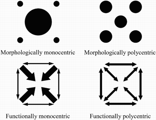
It is widely contended that urban settlement patterns are being reshaped by various influences that encourage more polycentric forms of development both at the intra-urban and inter-urban scales (Davoudi, Citation2003; Kloosterman & Musterd, Citation2001). One form of polycentric development that has been observed at the regional scale is that of the PUR. Similar terms appearing in the literature include ‘networked city-regions', ‘multicore city-regions' and ‘polynucleated metropolitan regions'. Although not clearly defined, PURs are commonly understood as clusters of proximate but physically separate settlements. Settlements are generally expected to be relatively even in size and spread across the region, although the broader concept is also applied to ‘city-regions' (an urban system consisting of a dominant city and satellite settlements). However, a PUR is distinct from polycentric development that takes place at a smaller scale within a metropolitan area or a conurbation, where previously separate settlements are linked by urban sprawl into a continuous extensive urban area. Importantly, PURs are also associated with strong, complex and less hierarchical functional inter-linkages between centres. ‘Complementarism’, the tendency towards centre specialisation coupled with greater interaction between centres, may also be evident (Kloosterman & Musterd, Citation2001; Parr, Citation2004; OECD, Citation2006; Meijers, Citation2007). Although the PUR concept was popularised in the late 1990s, it is still subject to debate and a degree of ambiguity (Burgalassi, Citation2010; Meijers, Citation2008). As discussed later, an unresolved debate is the emphasis placed on ‘morphology’ (the spatial settlement pattern) versus ‘functional linkages (interactions between centres).
Commonly cited examples of PURs include densely populated, highly economically productive areas such as the Randstad in the Netherlands, the Rhein-Ruhr area in Germany, industrial clusters in north-eastern Italy and the Pearl River Basin in China. By way of example, the Randstad region consists of four major centres (Amsterdam, Rotterdam, The Hague and Utrecht) and many smaller centres. Although densely populated, it has significant undeveloped environmental and recreation spaces between settlements. No single city is especially large, but collectively the area operates at a global level in a similar manner to that of a global city (OECD, Citation2007).
2.2 Theoretical underpinnings
The concept of PURs is part of a broader resurgence of interest in regionalism that has had an important influence on contemporary understanding of urban systems at a regional scale (Davoudi, Citation2003; Turok & Bailey, Citation2004). In the literature it is argued that the traditional central place understanding of urban systems, characterised by rigid hierarchical systems consisting of a dominant urban centre and different levels of subordinate sub-centres, is outdated and should be replaced by a regional urban network view that emphasises less hierarchical, polycentric patterns of development as well as complex functional inter-linkages between urban centres (Hall, Citation1997; Kloosterman & Musterd, Citation2001).
The emergence of polycentric settlement patterns has been linked to a number of factors. Recent advances in transport and communications technology have allowed social and economic interactions to take place over significantly greater distances, resulting in the overlapping of urban catchment areas of previously separate settlements. This has led to functional integration at a regional scale and the undermining of the metropolitan area as an independent urban system. These advances, together with increased levels of car ownership, have allowed both households and firms greater flexibility in location and have given rise to more dispersed development, the emergence of decentralised urban centres and complex travel patterns (Garreau, Citation1991; Kloosterman & Musterd, Citation2001; de Goei et al., Citation2010). In addition, increased exposure to global competition has encouraged industries, especially knowledge-intensive industries and ‘non-routinised’ production, to cluster in cities or within a regional network of cities to take advantage of benefits derived from economic agglomeration and localised competitive advantages. Six types of agglomeration benefits are identified. Firstly, firms benefit from larger local markets. Secondly, firms gain access to larger and denser labour markets, which makes it easier to find specialist skills and lowers recruiting costs. Employees also benefit from a greater choice of potential employers and better career opportunities. Thirdly, firms benefit from a greater range and better quality of supporting services. This may include specialist business services such as marketing, legal or design services or specialist facilities or physical infrastructure such as good roads and airports. Fourthly, economies develop institutional norms, including rules and conventions for doing business, which can serve to reinforce the competitive advantage of a region. Fifthly, firms benefit from better flows of information and ideas. Face-to-face meetings remain important for the transfer of complex knowledge and for building trust. Lastly, trade knowledge is transferred between firms by informal networks, chance meetings, the transfer of skilled staff and by firms directly observing each other, facilitating learning and innovation (Scott, Citation2001, Citation2002; Storper & Venables, Citation2004).
2.3 The polycentric urban region concept in policy
While originally a theoretical concept for understanding regional urban systems, polycentric development has been enthusiastically embraced as a normative objective by urban policy-makers and has had an important influence on regional policy internationally, especially in Europe where it has been a central theme of regional spatial policies since the late 1990s (Davoudi, Citation2003; Parr, Citation2004; Meijers, Citation2008).
Policy-makers have increasingly viewed the region as the most appropriate scale for policy intervention and infrastructural coordination. Relative to the local level, it allows for greater economies of scale, avoids institutional duplication and allows for the consistent marketing of the region. As economic systems are understood to operate at the regional scale, it follows that regional planning authorities rather than individual local governments or national government are best placed to ensure effective planning. Similarly, partnerships are believed to be more effective as knowledge of problems is expected to be greater at this level than at the national level (Porter, Citation2003; Turok & Bailey, Citation2004; Rogerson, Citation2009).
Secondly, the concept is popular with policy-makers as a means to enhance regional economic competitiveness through improving regional linkages between firms and other role-players. It is argued that a better integrated region stands to benefit more from economies of scale and the advantages of economic agglomeration. This is captured by the concept of ‘borrowed size’, where smaller settlements can enjoy the economic benefits typical of a larger centre if well integrated within the region (Parr, Citation2004; Turok & Bailey, Citation2004). A related concept is the promotion of complementary relationships, where different settlements take on specialised roles (Kloosterman & Musterd, Citation2001; Parr, Citation2004; OECD, Citation2006; Meijers, Citation2007). For example, the three leading centres in the previously mentioned Randstad area have developed specialised roles: Amsterdam (commercial services), Rotterdam (transportation) and the Hague (public administration) (Kloosterman & Musterd, Citation2001).
Thirdly, the concept is promoted as a means of achieving more balanced regional growth by steering growth pressures away from core cities and towards a network of satellite centres in order to avoid negative aspects of economic concentrations such as congestion, high land prices, pollution and damage to the heritage of historical centres. This pattern of economic growth that is regionally dispersed but concentrated within urban centres is seen as a way of increasing equity and spreading prosperity while avoiding urban sprawl and excessive car dependencies. Thus polycentric development is promoted as a means of achieving the seemingly incompatible goals of maximising the economic benefits associated with urban concentration while avoiding the negative consequences and allowing for more balanced regional growth. This concept was adopted by the European Spatial Development Perspective (European Commission, Citation1999), which was highly influential internationally, including in South Africa (Davoudi, Citation2003; Parr, Citation2004; Turok & Bailey, Citation2004; Meijers, Citation2008; Rogerson, Citation2009).
2.4 Criticisms of the polycentric urban region concept
The polycentric development concept has been criticised for its theoretical weakness, its imprecise definition and its emphasis on internal linkages at the expense of external linkages (Kloosterman & Musterd, Citation2001; Davoudi, Citation2003; Meijers, Citation2008). Empirical support for its ability to explain actual regional development patterns has been clouded by conflicting results, the varying scales to which the concept has been applied, and issues pertaining to its definition and measurement (Kloosterman & Musterd, Citation2001; Davoudi, Citation2003; Parr, Citation2004; Meijers, Citation2008; de Goei et al., Citation2010). Empirical evidence for the purported economic, equity and environmental benefits of polycentric development has also been unconvincing and is difficult to establish due to the large range of factors, other than spatial structure, affecting regional performance (Lambooy, Citation1998). Parr (Citation2004) argues that the literature has been biased towards the study of high-performing regions and thus does not give a true reflection on the general performance of PURs.
It is unclear why a PUR spatial structure should perform better than that of a single city as many of the advantages ascribed to PURs are arguably more applicable to a metropolitan area. Parr notes that ‘within the PUR there will be necessarily longer travel flows with respect to commuting, longer commodity flows and less convenient flows of information, all relative to those occurring within a single metropolitan area of comparable population’ (2004:236). Similarly, some of the advantages of agglomeration stem from proximity, face-to-face contact, informal networks and unplanned interactions, which are believed to be maximised in dense urban centres typically found in large cities rather than in PURs (Parr, Citation2004).
Finally, it is also unclear whether the successes enjoyed in high-performing PURs can be replicated in other areas through policy intervention aimed at encouraging polycentric development (Parr, Citation2004; Rogerson, Citation2009).
3. New regionalism and polycentric development in South Africa
Academic interest in new regionalism in South Africa has so far been limited, and the concept of polycentric development has attracted even less attention. Rogerson (Citation2009) examined the influence of new regionalism in South Africa, Pieterse (Citation2008) reviewed regional development initiatives in the Western Cape, and Pillay (Citation2004) contends that South African city-regions, with the possible exception of the Johannesburg area, are insufficiently developed to be considered ‘global city-regions'.
Nevertheless, there is a growing interest in regional policy (Pieterse, Citation2008; Rogerson, Citation2009) and the influence of the polycentric regional development concept is evident in a number of spatial and regional planning policy documents originating from all three tiers of government since 2003. Several policies recognise the existence of and role that ‘city-regions' play in South Africa and call for better regional planning, regional integration and improved connectivity within regions. However, not all policies embrace polycentrism. The National Spatial Development Perspective (The Presidency, Citation2007) is a prominent example of new regionalist policy in South Africa. This is clearly influenced by European Spatial Development Perspective, although it does not adopt the principle of polycentric development (Rogerson, Citation2009). Arguments for city-regionalism are often more concerned with the relationship between a centre and its periphery rather than the system of settlements within the region. Other policies contain more direct references to polycentric development; for example, the draft National Urban Development Framework, in motivating for greater support for city-regions, argues ‘one of the main objectives should be to increase connectivity within each city-region so as to improve functional efficiency for businesses and access to opportunities for households. This included rapid transit systems, freight logistics and broadband’ (Department of Cooperative Governance and Traditional Affairs & The Presidency, Citation2009:41). Polycentric development is most clearly addressed in provincial and metropolitan-level spatial planning policy. The Gauteng Spatial Development Perspective (Gauteng Province, Citation2007) adopts a polycentric city-region approach and recognises the importance of developing complimentary, interdependent urban centres and the clustering of firms in achieving global competitiveness.
In the Western Cape, the Provincial Spatial Development Framework (PGWC, Citation2005) and the Cape Town Spatial Development Framework (CoCT, Citation2012) outline an essentially polycentric spatial vision for the region, calling for a balanced regional network of settlements, integrated regional planning, greater linkages between settlements and a province-wide system of urban edges (urban growth boundaries) to limit urban sprawl. The policies propose that future development be spread across a network of existing regional settlements rather than confined to the dominant city, Cape Town. The growth of satellite towns and smaller cities is encouraged to complement (PGWC, Citation2005; CoCT, Citation2012) or even ‘act as counter-magnets to the growth dynamic of metropolitan Cape Town’ (CoCT, Citation2006:10). This approach was followed up with the commissioning of an extensive investigation into the growth potential of towns in the Western Cape (see van Niekerk et al., Citation2010; Donaldson et al., Citation2012).
Particular attention has been given to the coordination of regional development in the Western Cape and the role of provincial government. This includes the intergovernmental process set in motion by the Presidential Imbizo held in Cape Town in December 2005, which ultimately resulted in the 2008 OECD Territorial Review (Pieterse, Citation2008). Other examples include cluster support for key industries (Rogerson, Citation2009), regionally orientated tourism and business promotion, initiatives such as the ‘Cross-Border Collaboration’ initiative of the Department of Economic Development and Tourism (see Wolpe, Citation2010) and the steps taken towards the establishment of a province-wide economic development agency.
4. Approaches to measuring polycentric development
Polycentric development is expected to result in more complex regional settlement patterns characterised by: more even spatial distribution of development, greater economic specialisation of urban centres and the breakdown of size–function relationships, and more intense and less hierarchical interactions between urban centres (Kloosterman & Musterd, Citation2001; Limtanakool et al., Citation2007; Meijers, Citation2007, Citation2008). There is a rich literature dealing with issues of defining polycentric development as well as the technicalities of its measurement; for example, see Burgalassi (Citation2010), Burger & Meijers (Citation2012), de Goei et al. (Citation2010), Dühr (Citation2005), Limtanakool et al. (Citation2007, Citation2009), Meijers (Citation2007, Citation2008) and Vasanen (Citation2012).
A key debate in the literature is the relative emphasis placed on either ‘morphological polycentricity’ (the spatial settlement structure of the region) or ‘functional linkages' (interactions taking place between centres). This is conceptually illustrated in . Some authors understand polycentric development purely as a physical phenomenon (e.g. Meijers, Citation2008), while others argue that the analysis of flows provides a better indication of polycentricity (e.g. Limtanakool et al., Citation2007; de Goei et al., Citation2010; Vasanen, Citation2012). Others have adopted a multidimensional approach using both types of analysis or propose methods for integrating both approaches (e.g. Green, Citation2007; Burgalassi, Citation2010; Burger & Meijers, Citation2012).
Figure 1: Morphological polycentricism versus functional polycentricism
4.1 Measuring ‘morphological polycentricism’
The most popular technique for measuring morphological polycentricism is the rank-size method, which evaluates the size distribution of settlements in the region. Population is usually used as the measure of settlement size although economic production is also frequently used. An alternate measure is the standard deviation of settlement size, although this is considered inferior to the rank-size method (Meijers, Citation2008). Morphologically, regions can range from highly polycentric (many similar-sized centres evenly dispersed across the region) to highly monocentric (one large dominant centre or centres clustered closely together).
4.2 Measuring ‘functional polycentricism’
Measures of functional’ polycentricism analyse interactions or ‘flows' between centres and assess the overall level of interdependency in the region and the degree to which the pattern of interactions are either hierarchical or network like. Monocentric regions are characterised by simple, hierarchical patterns of interactions with flows focusing on a single dominant centre. In contrast, strongly networked polycentric regions are characterised by higher levels of interdependency and more equal and complex patterns of interactions (see ). Interactions between urban centres can take many forms including flows of information, money, goods and services, commuter trips and recreational trips; however, most studies have used commuter flows – largely because of the greater availability and reliability of this information (Davoudi, Citation2003; Green, Citation2007).
Functional polycentricism is also associated with the concept of ‘complementarism’ (economic specialisation within the region). Smaller centres may specialise in particular economic functions normally only found in large centres, thus leading to the ‘breakdown in size–function relationships' that are associated with more hierarchical systems. Complementarism is expected to lead to greater levels of interdependency and thus more intense and more symmetrical flows. However, some empirical studies suggest that greater economic specialisation does not always occur at a regional level (see Kloosterman & Lambregts, Citation2001; Meijers, Citation2007). Thus, while increasing specialisation among urban centres can be interpreted as a sign of polycentric development, lack thereof does not necessarily imply the opposite.
5. Methods used for assessing polycentric development in the Cape Town city-region
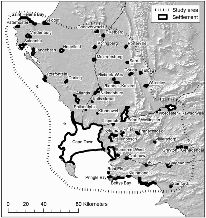
A more detailed description of data sources and methods is provided in Appendix A. Briefly, the study area was defined based roughly on an hour's travel from Cape Town and includes Cape Town and 44 smaller settlements, as shown in .
Figure 2: Map showing the study area and settlements identified within the study area
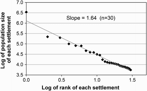
The region was assessed for both morphological and functional aspects of polycentrism. Morphological polycentrism was measured using the rank-size method using population data for 1991, 1996, 2001 and 2011, and changes in the size distribution of settlement over this period were assessed. In accordance with this method, settlements were ranked from largest to smallest and the population size and rank of each settlement were plotted on the y and x axes respectively using log scales. For example, shows the rank-size distribution of the largest 30 settlements in the region in 2011. The resulting points are expected to form a straight line and the slope of this line is used as the measure of polycentrism. Flatter slopes (slope values <1) indicate polycentric regions (i.e. a region where settlements are relatively equal in size), while steeper slopes (slope values >1) indicate monocentric regions, where settlements are relatively unequal in size.Footnote2 As results obtained from this method are sensitive to the number of settlements included in the analysis, this slope was calculated for varying numbers of settlements.
Figure 3: Rank-size distribution for 2011 (30 settlements included in the analysis)
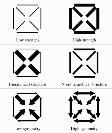
Functional polycentrism was assessed using ‘origin–destination’ transportation information based on morning commuter flows to examine linkages between settlements. Inter-settlement commuter patterns were reviewed with reference to a network assessment framework proposed by Limtanakool et al. (Citation2007, Citation2009). They propose three dimensions for characterising network configurations: strength, structure and symmetry, as conceptually shown in . Strength refers to the intensity of interaction between settlements. Structure is concerned with the distribution of interactions, and ranges from configurations where interactions are dominated by one or more settlements to configurations where all links are of equal strength. Symmetry is defined as the degree to which flows between settlements are reciprocal (equal in both directions).
Figure 4: Framework for assessing functional polycentrism: strength, structure and symmetry Citation2009).
6. Results
6.1 Morphological polycentrism
As previously mentioned, shows the rank-size distribution for the 30 largest settlements in the region in 2011. This firstly shows that the rank-size distribution of settlements is log-linear as predicted by the rank-size rule. Secondly, the slope is 1.64, which is steeper than the benchmark slope of one thus indicating a strongly monocentric rank-size distribution.
While shows the slope calculated specifically for 2011 using 30 settlements, shows the results for all four census years calculated repeatedly using between four and 45 settlements. The slope value is plotted on the y axis and the number of settlements included in the calculation is plotted on the x axis. This shows that steep slopes (ranging from approximately 1.6 to 2.2) were obtained for all years irrespective of the number of settlements included, confirming a strongly monocentric rank-size distribution. This is comparable with other strongly monocentric regions; for example, the Ile de France region (Paris; 1.73). In contrast, more neutral regions include the Madrid region (1.14) and Catalonia (Barcelona; 0.97), while polycentric regions include Andalucía (Seville, Granada, Cordoba; 0.88) and Tuscany (Florence; 0.72)Footnote3 (Bertolini et al., Citation2011).
Figure 5: Slope of the rank-size of settlement regression line by the number of settlements included in the regression
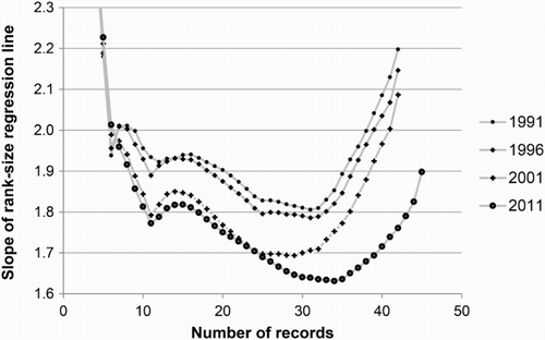
also shows temporal trends over the period 1991–2011. Consistently lower values (i.e. flatter slopes) were obtained over time when seven or more settlements are included in the calculation, suggesting a general trend towards polycentrism. This indicates that smaller settlements have on average grown faster than larger settlements, as reflected by the drop in percentage population living within the largest five settlements (from 91.7% to 89.2%). shows that the highest growth rates were experienced in smaller towns with high amenity, such as Hermanus/Hawston and Franschhoek. However, the trend towards polycentrism is not evident when comparing growth rates of the larger settlements in the region. shows that the dominant city, Cape Town, and the adjacent settlement Somerset West have experienced relatively strong growth and have not lost ground to secondary regional settlements such as Paarl/Wellington, Worcester/Rawsonville, Stellenbosch and Atlantis, as would be expected in a scenario of polycentric growth.
Table 1: Population and population growth for the largest 20 settlements within the Cape Town city-region
6.2 Functional linkages
diagrammatically shows morning commuting flows between settlements. The thickness of the lines indicates the number of trips between settlements and the numbers on the map reflect the number of trips for some of the dominant links. a shows gross flows (i.e. the sum of flows in both directions). b shows the same information disaggregated by direction. c shows net flows (i.e. the difference between flows in either direction).
Figure 6: Morning commuting flows between Cape Town and adjacent settlements:
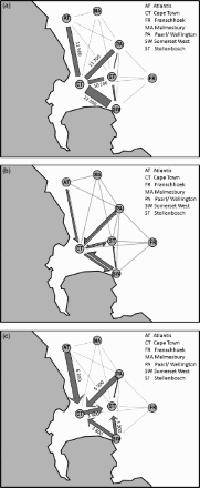
An evaluation of the pattern of functional linkages, with reference to the concepts of network strength, structure and symmetry, as outlined in Section 5, suggests the following. Firstly, the overall strength of interactions is relatively weak. a indicates a relatively low number of trips between settlements other than Cape Town. In addition, the total number of inter-settlement trips (69 000) is small relative to total intra-settlement trips (1 102 000) or even trips made just within Cape Town (947 000). Inter-settlement trips amount to less than 6% of all trips made within the region.
Secondly, the structure is strongly monocentric, as evident in the radial pattern shown in a. A relatively high percentage (84%) of total of inter-settlement trips is made either to or from Cape Town. The dominance of Cape Town is also evident in the asymmetry of flows (b). In total, more morning trips are undertaken to Cape Town (35 000) than from Cape Town (23 000).
Finally, the results suggest a degree of functional polycentrism in the case of Stellenbosch and, to a lesser extent, Somerset West. Evidence for this is the moderate strength of connections between Stellenbosch and other non-primary settlements Paarl/Wellington (2200 trips) and Somerset West (5000 trips) (a). A total of 8400 trips were made to or from Stellenbosch from settlements other than Cape Town, representing nearly 40% of all trips between settlements other than Cape Town. In addition, net flows to Stellenbosch are recorded from Paarl/Wellington (1100 trips), Cape Town (6200 trips) and Somerset West (3300 trips) (c). This may be due to concentrations of job opportunities in Stellenbosch, the presence of the University of Stellenbosch, rapid urban growth on urban peripheries, housing price differentials between Stellenbosch and suburbs in Somerset West or outlying Cape Town suburbs or its proximity to Cape Town. The relatively symmetrical flow between Cape Town and Somerset West shown in b also suggests functional polycentrism in the case of Somerset West. A more detailed analysis revealed that morning trips from Cape Town to Somerset West primarily originated from outlying suburbs with limited employment opportunities such as Khayelitsha, Blue Downs and Eerster River.
7. Discussion
7.1 Discussion on empirical evidence
The first objective of this paper is to review empirical evidence for the emergence of polycentric development patterns. The results suggest that the city-region is monocentric both in terms of morphological and functional polycentricity. This mirrors the metropolitan economic structure of metropolitan Cape Town that is also believed to be monocentric (Sinclair-Smith & Turok, Citation2012). The steep slopes obtained from rank-size distributions for all four years suggest that the region is strongly morphologically monocentric. The consistently decreasing slope values obtained from 1991 to 2011, when seven or more settlements are included in the calculation, suggest a general trend towards more polycentric settlement patterns over this time period based on the relatively stronger growth of smaller settlements in the region. However, this trend is offset by the relatively weak growth of secondary cities, such as Paarl/Wellington, Worcester/Rawsonville and Stellenbosch, relative to the dominant city, Cape Town, over this period. The analysis of commuter flows suggests that the region is generally functionally monocentric, although travel patterns to and from Stellenbosch and, to a lesser extent, Somerset West appear to be more polycentric in nature.
A number of limitations should be noted. Firstly, the rank-size analysis uses population figures and a positive relation between population size and economic productivity is assumed. An implicit assumption is that urbanising populations are attracted to areas of greatest economic opportunity. However, population increases may also reflect concentrations of poverty rather than increased economic production; for example, populations in settlements with agricultural hinterlands may be swelled by displaced farmworkers. Although it is unclear how this may affect the results, this may bias the results towards showing increased polycentrism. Secondly, commuter data used in this analysis are relatively old and it would be interesting to see how commuter flows have changed in recent years.
7.2 Implications for spatial policy for the Cape Town city-region
The second objective of this paper is to comment on implications for regional spatial planning. As outlined in Section 2.3, the concept of polycentric regional development is commonly applied to affect three types of outcomes: improved efficiency through economic coordination at a regional level, increased productivity due to economies of scale, and to exploit various economic, environmental and social benefits derived from a polycentric spatial settlement structure.
7.2.1 Regional coordination
There appears to be a relatively strong case for enhanced economic coordination at the regional level. Substantial economic coordination in the Western Cape already occurs at the provincial level (Pieterse, Citation2008; Rogerson, Citation2009) and key economic sectors such as agri-processing, business process outsourcing and port-related activities are regionally based and not well represented at the national level. The importance of improved regional coordination is highlighted by the 2008 OECD review, which raises concern regarding the high degree of organisational and policy fragmentation in region.
7.2.2 Benefits of agglomeration
Measures to increase economic productivity typically focus on improving interregional linkages. This may take the form of improved physical connective infrastructure, such as roads, railway lines or broadband electronic connectivity, or initiatives aimed at improving networking and communication channels between firms and economic role-players in the region. The logic is that by improving linkages, firms in the region stand to benefit more from the advantages of economic agglomeration, such as larger local markets and labour pools, or benefit from the efficiencies derived from complementary relationships where firms in a similar sector are clustered together. However, potential benefits may be limited by the relatively small sizes of towns in the Cape Town region. For instance, the population of Paarl/Wellington, the largest settlement in the region aside from Cape Town and adjacent Somerset West, is 18 times smaller in population terms than Cape Town. In addition, it may not be feasible to improve regional transport linkages to levels sufficient for the realisation of regional economic agglomerations. This may also be difficult to achieve in South Africa where public transport is less developed than in Europe and transport is relatively more expensive as populations here are generally poorer. There is a risk that new regionalist-inspired policy may result in the over-emphasis of regional transport connections at the expense of metropolitan connections, which handle the bulk of all trips undertaken in the region.
7.2.3 Benefits of a polycentric regional structure
A third policy option is to steer the urbanising population and public and private investment towards towns and smaller cities in the region in order to create a more polycentric regional settlement pattern. The objective here would be the realisation of the various environmental, social and economic benefits associated with a PUR structure. These include greater economic inclusion, more regionally balanced development and enhanced economic performance through the realisation of economies of scale while avoiding costs associated with congestion. However, the theoretical grounding for this is weak and empirical evidence is unconvincing (Davoudi, Citation2003; Parr, Citation2004; Turok & Bailey, Citation2004). Of particular relevance for the Cape Town region is the lack of reliable evidence for a PUR being more efficient than a single metropolitan. This point is emphasised by Parr (Citation2004:238), who contends that ‘it is incumbent on the policy maker to demonstrate that the economic efficiency of the PUR's spatial structure is superior to existing spatial structures, or at least no worse’.
It may prove difficult to sufficiently manipulate the growth trajectories of smaller settlements and towns in the region through policy intervention in order to have any meaningful impact on regional settlement structure. The relative small size of these settlements may limit their potential to accommodate the urbanising population at a meaningful scale. Any significant population influx to small settlements in the region could potentially swamp existing populations and infrastructure. It should further be noted that settlement size distribution patterns have been shown to remain stable over long periods of time (Batty, Citation2001).
Purported environmental benefits may be offset by increased travel demand and longer commuting distances associated with a PUR. Travel between regional centres is more likely to be made by car as public transport links between regional settlements are less developed than within metropolitan Cape Town. It is not clear how urban encroachment on environmental areas in the region, including high bio-diversity areas or cultural landscapes such as the Cape Winelands, will be affected by a more polycentric regional structure. Many towns in the region are located in sensitive environments. Without effective control of urban sprawl there is a risk that polycentric regional development strategies could result in regional sprawl. As Burgalassi (2010:41) aptly points out, polycentric development and urban sprawl, while contrasting concepts in theory and policy, are difficult to distinguish in practice.
Nevertheless, polycentric regional development may afford households and business a greater range of potential locations. For instance, industries may take advantage of cheaper rentals or lower labour costs outside metropolitan Cape Town. Households may choose to locate in cheaper or higher amenity neighbourhoods and commute to work in a different centre. Households in outlying Cape Town suburbs may find it easier to commute to employment centres in satellite towns such as Stellenbosch, Paarl or Worcester than the Cape Town Central Business District. Polycentric development may lead to ‘complementary development’ through the clustering of firms to exploit localised advantages. For example, port-related industry may cluster in Saldahna, tourism-related industry my cluster in areas of natural amenity such as Franshoek or Hermanus and agro-industry may cluster in settlements in proximity to agricultural areas such as Malmsbury or Grabouw.
In conclusion, while the merits of improving economic coordination at the regional level appear to be relatively uncontentious, this investigation – having considered theoretical grounds, available empirical evidence and the existing settlement structure of the region – suggests that there are limited grounds for policy intervention aimed at promoting a more evenly distributed regional population or for the prioritisation of inter-settlement infrastructural connections at the expense of metropolitan connections.
Acknowledgements
This work was undertaken through a partnership between the City of Cape Town and the University of Cape Town's African Centre for Cities and was supported by Mistra Urban Futures, a global research and knowledge centre in sustainable urban development, funded by the Swedish International Development Agency and the Mistra Foundation for Strategic Development. The author wishes to thank Owen Crankshaw for guidance and useful suggestions for the development of this paper. The author would also like to thank Ivan Turok for advice and comments on an earlier draft. The author is also grateful to colleagues at the City of Cape Town for assistance with data used in this analysis.
Notes
2A positive slope value is used for convenience. The slope is actually always negative.
3All values quoted are based on 15 settlements. For comparison, the slope value for the Cape Town region for 2011 using 15 settlements is 1.82.
References
- Batty, M, 2001. Polynucleated urban landscapes. Urban Studies, 38(4), 635–55. doi: 10.1080/00420980120035268
- Bertolini, P, Giovannetti, E & Pagliacci, F, 2011. Regional patterns in the achievement of the Lisbon Strategy: A comparison between polycentric regions and monocentric ones. CAPPaper n.97, University of Modena & Reggio Emilia, Modena. http://www.capp.unimore.it/pubbl/cappapers/Capp_p97.pdf Accessed 11 June 2013.
- Burgalassi, D, 2010. Defining and measuring polycentric regions.The case of Tuscany. Discussion Paper n.101, E-papers del Dipartimento di Scienze Economiche, University of Pisa, Pisa. http://mpra.ub.uni-muenchen.de/25880/1/Burgalassi_discussion_paper.pdf Accessed 21 January 2011.
- Burger, M & Meijers, E, 2012. Form follows function? Linking morphological and functional polycentricity. Urban Studies 49(5), 1127–49. doi: 10.1177/0042098011407095
- CoCT (City of Cape Town), 2006. Cape Town 2030: An Argument for the Long Term Spatial Development of Cape Town. City of Cape Town, Cape Town. http://www.capetown.gov.za/en/IDP/Documents/Statutory%20compliance%20plans%202009-2010/Annexure%20B%20-%20FutureCapeTown.pdf Accessed 2 February 2014.
- CoCT (City of Cape Town), 2012. Cape Town Spatial Development Framework: Statutory Report. City of Cape Town, Cape Town. http://www.capetown.gov.za/en/sdf/Documents/SDF_Technical_Report_2012_Interactive.pdf Accessed 18 February 2013.
- Davoudi, S, 2003. European briefing: Polycentricity in European spatial planning: From analytical tool to a normative agenda. European Planning Studies 11(8), 979–99. doi: 10.1080/0965431032000146169
- de Goei, B, Burger, M, Van Oort, F & Kitson, M, 2010. Functional polycentrism and urban network development in the Greater South East, United Kingdom: Evidence from commuting patterns, 1981–2001. Regional Studies 44(9), 1149–70. doi: 10.1080/00343400903365102
- Department of Cooperative Governance and Traditional Affairs & The Presidency, 2009. National Urban Development Framework: Harnessing a common vision for growth and development of South Africa's towns, cities and city-regions (working draft for consultation). Prepared by the NUDF Steering Committee and in partnership with the South African Cities Network. http://africancentreforcities.net/papers/29 Accessed 14 January 2011.
- Donaldson, R, van Niekerk, A, du Plessis, D & Spocter, M, 2012. Non-metropolitan growth potential of Western Cape municipalities. Urban Forum 23(3), 367–89. doi: 10.1007/s12132-011-9139-4
- Dühr, S, 2005. Potentials for polycentric development in Europe: The ESPON 1.1. 1 project report. Planning, Practice & Research 20(2), 235–9. doi: 10.1080/02697450500414728
- European Commission, 1999. European Spatial Development Perspective: Towards a Balanced and Sustainable Development of the Territory of the European Union. Office for Official publications of the European Communities, Luxembourg.
- Gabaix, X, 1999. Zipf's Law and the growth of cities. The American Economic Review 89(2), 129–32. doi: 10.1257/aer.89.2.129
- Gabaix, X & Ioannides, Y, 2004. The evolution of city size distributions. Handbook of Regional and Urban Economics 4, 2341–78. doi: 10.1016/S1574-0080(04)80010-5
- Garreau, J, 1991. Edge City: Life on the New Frontier. Doubleday, New York.
- Gauteng Province, 2007. Gauteng Spatial Development Perspective. Gauteng Provincial Government, Johannesburg. www.ecodev.gpg.gov.za/GSDP%20Report%20Final2.pdf Accessed 22 May 2013.
- Green, N, 2007. Functional polycentricity: A formal definition in terms of social network analysis. Urban Studies 44(11), 2077–103. doi: 10.1080/00420980701518941
- Hall, P, 1997. Modelling the post-industrial city. Futures 29(4), 311–22. doi: 10.1016/S0016-3287(97)00013-X
- Kloosterman, R & Lambregts, B, 2001. Clustering of economic activities in polycentric urban regions: The case of the Randstad. Urban Studies 38(4), 717–32. doi: 10.1080/00420980120035303
- Kloosterman, R & Musterd, S, 2001. The polycentric urban region: Towards a research agenda. Urban Studies 38(4), 623–33. doi: 10.1080/00420980120035259
- Lambooy, J, 1998. Polynucleation and economic development: The Randstad. European Planning Studies 6(4), 457–67. doi: 10.1080/09654319808720474
- Limtanakool, N, Dijst, M & Schwanen, T, 2007. A theoretical framework and methodology for characterising national urban systems on the basis of flows of people: Empirical evidence for France and Germany. Urban Studies 44(11), 2123–45. doi: 10.1080/00420980701518990
- Limtanakool, N, Schwanen, T & Dijst, M, 2009. Developments in the Dutch urban system on the basis of flows. Regional Studies 43(2), 179–96. doi: 10.1080/00343400701808832
- Meijers, E, 2007. Clones or complements? The division of labour between the main cities of the Randstad, the Flemish Diamond and the Rhein Ruhr Area. Regional Studies 41(7), 889–900. doi: 10.1080/00343400601120239
- Meijers, E, 2008. Measuring polycentricity and its promises. European Planning Studies 16(9), 1313–23. doi: 10.1080/09654310802401805
- OECD (Organisation for Economic Cooperation and Development), 2006. Territorial Reviews: Competitive Cities in the Global Economy. OECD, Paris.
- OECD (Organisation for Economic Cooperation and Development), 2007. Territorial Reviews: Randstad Holland, Netherlands. OECD, Paris.
- OECD (Organisation for Economic Cooperation and Development), 2008. Territorial Reviews: Cape Town. OECD, Paris.
- Parr, J, 2004. The polycentric urban region: A closer inspection. Regional Studies 38(3), 231–40. doi: 10.1080/003434042000211114
- Pieterse, E, 2008. Regional development: Strategies for the future. State of the Province, Report 2008: Chapter 10. http://africancentreforcities.net/papers/4/ Accessed 5 May 2011.
- Pillay, U, 2004. Are globally competitive ‘city regions’ developing in South Africa? Formulaic aspirations or new imaginations? Urban Forum 15(4), 340–64. doi: 10.1007/s12132-004-0013-5
- Porter, M, 2003. The economic performance of regions. Regional studies 37(6–7), 549–78. doi: 10.1080/0034340032000108688
- PGWC (Provincial Government Western Cape), 2005. Provincial Spatial Development Framework. PGWC, Cape Town. http://www.westerncape.gov.za/text/2005/12/1-3_cfgdtc_pages_1-50_web.pdf Accessed 2 February 2014.
- Rogerson, C, 2009. The turn to ‘New Regionalism’: South African reflections. Urban Forum 20(2), 111–40. doi: 10.1007/s12132-009-9057-x
- Scott, A, 2001. Globalization and the rise of city-regions. European Planning Studies 9(7), 813–26. doi: 10.1080/09654310120079788
- Scott, A, 2002. Regional push: Towards a geography of development and growth in low and middle-income countries. Third World Quarterly 23(1), 137–61. doi: 10.1080/01436590220108216
- Sinclair-Smith, K & Turok, I, 2012. The changing spatial economy of cities: An exploratory analysis of Cape Town. Development Southern Africa 29(3), 391–417. doi: 10.1080/0376835X.2012.706037
- Statistics South Africa, 2012. Census 2011 – Census in Brief. Statistics South Africa, Pretoria.
- Storper, M & Venables, A, 2004. Buzz: Face-to-face contact and the urban economy. Journal of Economic Geography 4(4), 351–70. doi: 10.1093/jnlecg/lbh027
- The Presidency, 2007. National Spatial Development Perspective 2006. The Presidency Policy Coordination and Advisory Services, Pretoria. http://www.npconline.co.za/MediaLib/Downloads/Home/Tabs/Diagnostic/MaterialConditions2/The%20Presidency-%20National%20spatial%20development%20perspective.pdf Accessed 5 May 2013.
- Turok, I & Bailey, N, 2004. The theory of polynuclear urban regions and its application to Central Scotland. European Planning Studies 12(3), 371–89. doi: 10.1080/0965431042000195029
- van Niekerk, A, Donaldson, R, du Plessis, D & Spocter, M, 2010. A Revision of 2004 Growth Potential of Towns in the Western Cape Study: Discussion Document: A Research Study Undertaken for the Department of Environmental Affairs and Development Planning of the Western Cape Provincial Government. Stellenbosch University & CSIR, Stellenbosch. http://academic.sun.ac.za/cga/downloads/GPS2010_discussion_document.pdf Accessed 2 February 2014.
- Vasanen, A, 2012. Functional polycentricity: Examining metropolitan spatial structure through the connectivity of urban sub-centres. Urban studies 49(16), 3627–44. doi: 10.1177/0042098012447000
- Wolpe, R, 2010. Western Cape Cross-Border Collaboration Initiative: International case studies of economic development focused cross border initiatives and networks: Discussion document for comment. Unpublished document, Wolpe Strategic Economic Consulting, Cape Town.
- World Bank, 2009. World Development Report 2009: Shaping Economic Geography. World Bank, Washinton, DC.
- Zipf, G, 1949. Human Behaviour and the Principle of Least Effort. Addison-Wesley, Cambridge, MA.
Appendix A: Explanation of methods used and data sources
Demarcation of study area
The study area was determined based on the ‘functional city-region’ concept. A commonly used practical definition thereof is the catchment area for daily commuting between the main centre and satellite towns, with one hour of travel generally accepted as the maximum limit (Davoudi, Citation2003; Turok & Bailey, 200; OECD, Citation2008). Accordingly, approximately one hour of travel by car measured from the satellite settlement to the closest economic node within Cape Town (e.g. the Tygervalley area rather than the Cape Town Central Business District) was used to determine the study area extent. Settlements were treated as discrete if separated by three or more kilometres provided that the data allowed for this spatial disaggregation.
Measuring morphological polycentrism: the ‘rank-size method’
The changing distribution of settlement sizes, based on population size, was assessed using a widely accepted measure of morphological polycentrism called the ‘rank-size method’. It is based on a regularity observed in the size distribution of settlements known as Zipf's Law (Zipf, Citation1949), which states that the probability of the occurrence of a settlement of any given size is inversely proportional to its size. This law can be visualised by ranking all settlements from largest to smallest and plotting the population size and rank of each settlement using log scales. The resulting points almost always fall into a straight line irrespective of the area chosen for analysis (see ). Furthermore, the slope of this line has been found to be close to minus one for most regions internationally irrespective of income levels and is stable over long time periods (Gabaix, Citation1999; Batty, Citation2001; Gabaix & Ioannides, Citation2004; World Bank, Citation2009).
This regularity is particularly useful for measuring polycentrism. In the rank-size method, the slope of the rank-size graph is calculated and compared with the benchmark slope of minus one. A flatter slope indicates a more polycentric region. In contrast, a steeper slope indicates a more monocentric region, thus allowing for comparison across different areas or over time.
A weakness with this method is that results can be distorted by the more numerous smaller settlements. This is commonly resolved by determining cut-off points to prevent the inclusion of excessive numbers of small settlements. There is no specific rule for determining cut-off points and the number of settlements ultimately included in the calculation requires careful judgement (Meijers, Citation2008). Between five and 30 settlements are commonly used. However, this analysis follows an alternative, and potentially more illustrative method, as outlined by Burgalassi (Citation2010). This involves repeatedly calculating slope for different numbers of settlements included so that all results can be compared.
Processing of data
Population data were obtained from Statistics South Africa for census years 1991, 1996, 2001 and 2011. For each year, the population for urban settlements within the study area was identified and separated from the rural population. This was done by carefully examining census enumerator area boundaries and population densities using geographic information systems and aerial photography. This method was found to be more consistent than using the urban/non-urban classification of the census information. Forty-five separate urban settlements were identified within the defined study area as shown in . A number of minor data issues were noted. Firstly, statistical boundaries vary for the four censuses and there were small discrepancies in statistical boundaries for the different census years. Secondly, not all 1991 census data could be matched to geographic information system-based statistical boundaries. This affected less than 4% of the 1991 population.
The slope of the rank-size distribution of settlements was then calculated for all census years. For example, shows the rank-size distribution of the largest 30 settlements in the Cape Town region in 2011. Population size and rank of each settlement is plotted on y and x axes respectively using log scales.
The slope of the rank-size distribution was determined by ordinary least squares linear regression and is represented by the solid straight line in . In this example the slope is 1.64. As the results are sensitive to the number of settlements included in the regression, the slope was calculated repeatedly using between four and 45 settlements. The resulting slope values for all four census years are shown in .
Measuring functional linkages
Functional linkages were assessed using ‘origin–destination’ transport information for morning commuter flows obtained from the City of Cape Town Transport Department. The information was developed for transport planning purposes and is based on the 2001 census, a 2004 City of Cape Town household survey and calculations made by the department using transport modelling techniques. These data were updated periodically to take into account urban growth since 2001. The data were aggregated to match the settlement definition as described above and inter-settlement commuter flows were mapped diagrammatically.