
ABSTRACT
Glacier-permafrost interactions are investigated to understand glacial-hydrological influence along a partly glacierised valley on the NE flank of the Snøhetta massif, Dovrefjell, southern Norway. Of particular interest is how processes are controlled by a hydrological connection between landforms. Field mapping identified an ice-marginal landsystem comprising a polythermal glacier, a proglacial lake, an ice-cored moraine complex and a river-lake with perennial frost mounds. A clear interaction between glacial and periglacial processes was observed in transitional landforms, most prominently in the ice-cored moraine which constitutes a permafrost environment that is directly reworked by glaciofluvial processes. The role of this interaction in controlling seasonal, partial drainage of the proglacial lake was assessed using remote sensing-based observations of lake surface size evolution and seasonal surface subsidence. Results suggest a two-fold threshold for lake drainage: Depending on the dynamics of glacial discharge and active layer depth, the ice-cored moraine may either act as a barrier or a pathway to meltwater exiting the glacier. This demonstrates the importance of meltwater dynamics in controlling landform evolution in a glacial-periglacial landscape. To further assess the importance of surface and subsurface hydrology in linking glacial and periglacial domains, water stable oxygen isotope ratios across the study area were studied to map the flow of meltwater from glacier to permafrost. Results include a model of the surface and subsurface hydrology in the catchment and promote a conceptual understanding of water as a thermal, hydraulic and mechanical agent of transient glacier-permafrost interaction operating at heterogeneous timescales.
Introduction
Landscapes undergoing deglaciation are marked by rapid rates of change (Hewitt Citation2002; Hoffmann Citation2015). Deglaciation leads to geomorphic adjustments at various spatial and temporal scales, known as paraglacial processes (Church and Ryder Citation1972; Ballantyne Citation2002). Recently deglaciated surfaces such as the glacier foreland and sidewalls typically experience permafrost aggradation associated with initial ice recession and exposure to cold climate conditions. Further warming however leads to subsequent permafrost degradation and slope instabilities are common (Kneisel and Kääb Citation2007). Glacial-hydrological processes have a key role in landscape changes downstream. Meltwater transports sediments and heat across and beyond the proglacial area, impacting landscapes even at great distance from its origin (Hewitt Citation2002). Drainage of a proglacial lake can be a key provider of meltwater into the distal glacial foreland.
Phenomena regarding permafrost and glaciers are typically studied separately, even though they are often located in the same climatic zone (Harris and Murton Citation2005). If in close vicinity, glaciers and permafrost can actively act as a combined thermal and mechanical entity (Etzelmüller and Hagen Citation2005). In view of the current, rapid changes in the cryosphere due to climate change, understanding these glacier-permafrost interactions is crucial.
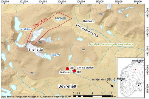
This study presents a comprehensive analysis of the glacial and periglacial landforms in a partly glaciated basin with a view to examining the specific influence of glacial-hydrological processes. Located at Dovrefjell in southern Norway (), the study site encompasses a small polythermal glacier on the NE flank of the Snøhetta mountain (2286 m asl), an ice-cored moraine damming a proglacial lake, the glacier forefield and a small river-lake area (Leirpullan, 1437 m asl, <0.1 km²) with several perennial frost mounds. In considering how the presence of a polythermal glacier influences ice-marginal landscapes, we examine both the processes and transitional landforms characteristic of the boundary between glacial and periglacial domains. We focus in particular on identifying the role of ice-cored moraines in relation to glacial meltwater discharge and proglacial lake drainage and the function of surface and subsurface hydrology in linking the glacial and periglacial domains.
Figure 1. Overview of the study area in southern Norway. Focus area at NE Snøhetta, Dovrefjell, is marked in red. Note the nearby climate station and boreholes at Snøheim.
Except for an investigation on the frost mounds at Leirpullan (Matthews et al. Citation1997), the study area is poorly studied. To date there has been no systematic examination of the processes and landforms occurring within the glacier foreland. The first aim hence was to identify and map the landforms using field data and remotely-sensed imagery and combine this with a geomorphometrical analysis of the study area. This approach allows gathering information about landform origin and the distribution of process regimes, without means of geophysical surveys. Based on the preliminary field observations revealing a sudden drainage of the proglacial lake into the marginal moraine via subsurface routeing, the temporal evolution of the proglacial lake was of particular interest and assessed using a time-series of satellite imagery. This study aims to identify the main factors controlling lake drainage as it is assumed to display a direct interaction between glacial and periglacial processes in the marginal moraine. Further remote sensing data is used to assess the morphological changes of the moraine following lake drainage.
The sampling of water at different locations in the study area forms an integral part of the research scope, aiming to evaluate water as a linking element between the landforms and processes of interest. Water samples were used to understand the role of water conduits in facilitating meltwater flow from glacier to permafrost and to evaluate the seasonal hydrological setting in a snapshot manner by assessing the stable hydrogen and oxygen composition. To address the conceptual role of surface and subsurface hydrology in the realm of a glacial-periglacial transitional landscape, a sketch of the meltwater pathways in the study area is presented.
Transitional landscapes, glacier-permafrost interactions and the role of proglacial hydrology
Transitional landforms and landscapes
Many landscape systems today do not appear to be in balance with external forces. Ongoing processes are the landscapes’ response to external shifts or perturbations such as tectonic or climatic changes. Some former conditions no longer apply to a present-day landscape while others may have changed their magnitude. Most often however, landscapes are subject to a number of different changes or repeated perturbations, resulting in a complex interlacing of adjustment processes (Hewitt Citation2002).
Processes in landscapes undergoing change produce landforms at intermedial developmental stages between conventionally recognised landform types. These transitional landforms are valuable proxies in paleoclimatic reconstructions, but often exist only at short time-scales as so-called temporary storage areas (Church and Ryder Citation1972) before transforming into landforms related to the new environmental conditions (Matthews et al. Citation2017).
Paraglacial environments constitute the transition from glacial to non-glacial environment. The term paraglaciation considers transitional processes and landforms of the periglacial and other domains that are directly preconditioned by glaciation (Church and Ryder Citation1972; Ballantyne Citation2002). Paraglacial activity is most often associated with the release of debris from oversteepened rock faces following the retreat of a buttressing ice mass. However, it may also apply to the relatively flat terrain of the glacier forefield, characterised by modification by freeze/thaw cycles, mass movements, running water and wind action (Ballantyne Citation2002). Changes propagate across the landscape according to a specific time lag or rate, resulting in a range of different response times (Bierman and Montgomery Citation2014). Additionally, some parts may currently be reacting to more recent changes, whereas other parts may still be in incomplete transition from past perturbations (Hewitt Citation2002; Bierman and Montgomery Citation2014). Often in the paraglacial phase of a landscape, subsystems operate at different, context specific response rates (Mancini and Lane Citation2020). Therefore, even supposedly simple landscapes may be the composite result of many interacting subsystems (Allen Citation2005). It is thus crucial to approach the variety and origins of landscape components in a nested and multi-temporal frame.
The temporal and spatial extent of glacier-permafrost interactions
The concept of paraglaciation may be the closest approach to an integrative glacier-permafrost perspective as it links periglacial processes to the dynamics of retreating glaciers. Paraglacial environments may thus include both proglacial and periglacial environments (Slaymaker Citation2009). In fact, the initial definition by Church and Ryder (Citation1972) considered the proglacial period as the earliest stage of the paraglacial. However, as Slaymaker (Citation2011) emphasises, the term paraglacial should not be understood as a simple substitute for periglacial and proglacial environments. There are no processes unique to a paraglacial environment, it is rather the assemblage of processes from different domains that follow deglaciation (Slaymaker Citation2009).
In a glacier-permafrost approach however, the concept of paraglaciation may remain unsatisfactory, as it solely considers the one-directional impact of glaciation on periglaciation and not vice versa (Dobiński et al. Citation2017). Glacial, paraglacial and periglacial landscapes may interlace temporally and spatially according to changing energy inputs (Thorn and Loewenherz Citation1987). While glacial landscapes are one-directionally reworked by the transient, paraglacial domain, periglacial landscapes may change into various directions, depending on the respective climate deterioration. Periglacial landscapes are considered to be under a stable energy input and in equilibrium with freeze/thaw activity as well as permafrost dynamics. However, they typically encompass different components of glacial, fluvial and purely periglacial process domains. The term periglacial landscape may therefore only be adequate at certain spatial scales (Slaymaker Citation2011). Proglacial landforms in contrast may be considered in quasi-equilibrium with erosional and depositional processes. Once the change in climatic conditions evokes different levels of energy input and a shift towards a different process domain, relict glacial and periglacial landscapes are affected by a transitional regime of disturbance (Slaymaker Citation2011).
In fact, the role of permafrost in relation to deglaciation and the potential preservation of transitional landforms have been of interest in recent research (e.g. Kokelj et al. Citation2017). In cold climates, permafrost can maintain glacial landforms in a stable state, limit sediment supply and delay the degradational processes of the paraglacial period (Astakhov and Isayeva Citation1988; Dyke and Evans Citation2003; Kokelj et al. Citation2017). A special perspective on glacier-permafrost interaction has been put forward by Dobiński et al. (Citation2011, Citation2017) who explore the possibility of glacial permafrost as originally introduced by Hughes Citation1973, relying on the purely thermal definition of permafrost. Accordingly, the 0°C-isotherm integrates the glacial and periglacial environment where the permafrost table translates into the ice near the pressure melting point at the glacier surface and the permafrost base extends along the so-called cold-temperate transition surface (CTS) between the temperate and the cold parts of a polythermal glacier. Glaciers and permafrost can thus be perceived on a common geophysical basis as they both feature a summer surface that allows the penetration of warm temperatures, a transient seasonal layer, the active layer and the glacier transient layer (Dobiński et al. Citation2017). Similarly, dead ice may be considered glacial permafrost in a periglacial, purely thermal sense (Dobiński et al. Citation2011).
Glacier-permafrost interactions and proglacial hydrological pathways
Many phenomena regarding glacier-permafrost interaction have been found involving polythermal glaciers with a distinct role of meltwater routeing in ice and sediment and the formation and drainage dynamics of proglacial lakes. Massive ground ice in proglacial areas points to present or recent glacier-permafrost interaction directed by glacial meltwater input (Liestøl Citation1977; Yoshikawa and Harada Citation1995; Liestøl Citation1996).
In a polythermal glacier with a cold front, meltwater may seasonally travel englacially towards the surface by upwelling from the temperate, relatively lower zones underneath. Meltwater typically emerges along weak zones of the glacier such as ice thrust faults (Irvine-Fynn et al. Citation2011). The location of the CTS has been found to vary largely (Pettersson Citation2004), revealing a complex variety of thermal properties. In a permafrost environment, the marginal parts of the accumulation area are commonly frozen to the mountain side and head wall, and the terminus of the glacier may similiarly be frozen to the ground (Etzelmüller and Hagen Citation2005). Temperate glacier ice is typically underlain by unfrozen ground (Pettersson Citation2004; Etzelmüller and Hagen Citation2005; Irvine-Fynn et al. Citation2011).
Proglacial areas are prime examples of transitional landscapes, as they typically feature high intensities in dynamic processes of landscape change including erosion and deformation (Heckmann et al. Citation2016). Proglacial streams show high seasonal and diurnal variability directed by the dynamics of glacial melt and the potential occurrence of permafrost (Church and Gilbert Citation1975). Permafrost largely impacts the regime of groundwater flow due to its lower hydraulic conductivity than unfrozen ground (Williams and Smith Citation1989; Waller et al. Citation2012). Subsurface flow increases with depth of the active layer with a high concentration along the permafrost table (Pecher Citation1994; Cooper et al. Citation2011). Surface waterbodies, such as lakes and rivers provide heat sources to the surrounding ground and often cause taliks in their periphery and at the same time may allow for the formation of perennial frost mounds, palsas and peat plateaus (Harris and Corte Citation1992).
The melt-out of buried ice and the formation of lakes are considered instrumental to the ‘de-icing’ of the ice-cored moraine complexes that are widely considered a key product of glacier-permafrost interactions (e.g. Schomacker and Kjær Citation2008). In many cases, a thick enough debris layer can preserve buried ice or refrozen meltwater and incorporate it directly into the permafrost system (Harris and Murton Citation2005). Once thermal conditions change, an increase of the active layer thickness may provoke the decay of the ice core and consequent rapid mass wasting within the moraine environment (Etzelmüller and Hagen Citation2005). Adjacent water bodies, rain and geothermal heating similarly transport heat into ice-cored moraines (Driscoll Citation1980; Watson Citation1980; Pickard Citation1983). Downwasting and backwasting are considered the two major processes involved in de-icing of moraines (Eyles Citation1979; Krüger Citation1994; Krüger and Kjær Citation2000; Lukas Citation2014).
Langston et al. (Citation2011) concluded that groundwater flow through a moraine is mainly concentrated along the margin between debris and bedrock. However, flow might be blocked or restricted by buried ice and ground ice respectively, forcing ground water flow to reroute to more permeable substrate. Relict glacial structures such as crevasses also play a vital role in the degradation process, as they precondition water and air pathways (Richardson and Reynolds Citation2000). The network of drainage conduits within the moraine changes seasonally, bound to the complete refreezing in winter. Seepage and piping are powerful in creating cavities in the subsurface of the moraine, which can trigger partial collapse and significantly lower the crest of the moraine (Awal et al. Citation2011). Ice-cored moraines likewise serve as significant storages and groundwater aquifers (Langston et al. Citation2011).
Proglacial lakes similarly constitute a temporary storage for sediment and glacial meltwater (Geilhausen et al. Citation2012; Otto Citation2019). If still in contact with the ice body, proglacial lakes can heavily impact the glacier’s mass balance, flow velocity and thermal regime (e.g. Carrivick and Tweed Citation2013). While the survival of a proglacial lake is primarily dependent on the stability of the dam, the lake in turn can heavily control the disintegration of the moraine. Lake water has shown to contain sufficient energy to induce melt and thaw processes in ice-rich substrate (Marsh and Neumann Citation2001).
Study site
Environmental setting
The study area () encompasses the cirque valley hosting a glacier to the NE flank of Snøhetta and extends towards the western end of Stroplsjødalen. The cirque glacier flanking Snøhetta to the north-east has not been officially named to date but has the assigned identification number 1734 in the Inventory of Norwegian glaciers of the Norwegian Water Resources and Energy Directorate (Andreassen et al. Citation2012) following earlier appearances in the inventories by Østrem and Ziegler (Citation1969) and Østrem et al. (Citation1988). It is further mentioned by Bogen (Citation1982) and also by Paasche (Citation2014) who observed it to be seemingly polythermal. Supraglacial meltwater streams feed the proglacial lake, at whose northern outlet surface flow is locally interrupted by a large marginal moraine.
The large marginal moraine damming the proglacial lake has been found to be visibly degrading, but ‘yet to be breached’ assumedly in the near future (Paasche Citation2014, p. 2). The moraine has not been dated, but is likely to be related to other distinct marginal moraines in the region indicating maximum glacial extent during the Little Ice Age.
Ground temperatures have been measured along an altitudinal transect at Dovrefjell since 2001 (Isaksen et al. Citation2002; Isaksen and Sollid Citation2002; Sollid et al. Citation2003), suggesting a lower limit of permafrost in the area at 1490 m asl (Isaksen et al. Citation2002). Isaksen et al. (Citation2002) estimated the local 0°C MAAT at northern Dovrefjell to occur at an altitude of ca. 910 m. Data from nearby Fokstua show an increasing trend in MAAT for the last decades (Hofgaard and Myklebost Citation2018).
Dovrefjell is mostly characterised by till deposits of spatially variable thickness from the Weichselian period covering metamorphosed, feldspathic sandstone bedrock from the Late Precambrian (Krill Citation1987). However, glaciofluvial sediments and glaciolacustrine sediments are commonly found along the valley floor in lower to middle parts of Stroplsjødalen (Bogen Citation1982; Follestad Citation2003).
The upper study area constitutes one of various tributary catchments to Leirpullan, a stream delta area in the NE sector of the study area, which is additionally fed by streams from west, north and south-east. Beyond the marginal moraine towards Leirpullan, the study area is largely covered by thin till of varying grain size and bedrock is exposed in many places. Along the north-western and the south-eastern shore of Leirpullan, thufur-fields are abundant.
Glacial and periglacial legacy
Oversteepened lateral rock walls form a parabolic valley around the present glacier hinting at a significantly thicker ice mass with strong erosional capacity. Proglacial deposition is most clearly expressed by the large disconnected marginal moraine consisting of unsorted block-dominated sediments. Other features formed by present proglacial deposition include glaciofluvial sediments in sandur deltas and other outwash zones.
The landscape history of the glaciated basins flanking the Snøhetta peak is indeed characterised by erosion, weathering and adjustment processes after the regional Late Weichselian glacier maximum as well as local glacial retreat since the Little Ice Age. Landforms emerging from periglacial fragmentation and sorting dominate the landscape especially stretching along the eastern plain below the Snøhetta massif (Isaksen et al. Citation2002; Sellier Citation2002; Kerguillec Citation2011; Kerguillec and Sellier Citation2012, Citation2021; Kerguillec Citation2013, Citation2014a, Citation2014b, Citation2014c).
The alpine peaks of Dovrefjell are strongly influenced by predominantly NE facing cirque-glaciation, given the dependency of solar radiation on aspect as well as prevailing S-SW snow bearing winds (Østrem et al. Citation1988; Dahl and Nesje Citation1992). Most cirques in Dovrefjell include an ice-cored moraine which often terminate within permafrost areas (Østrem Citation1964; Etzelmüller et al. Citation1996; Ødegård et al. Citation1996). Matthews et al. (Citation2014) demonstrate that ice-cored moraines in southern Norway were developing over a longer period than the Little Ice Age.
The periglacial heritage of the area is especially pronounced in the ubiquitous blockfields and patterned ground (Kerguillec and Sellier Citation2021). Sollid et al. (Citation2003) similarly identified the transition zone of mountain permafrost at an altitudinal belt ranging from approximately 1300 to 1550 m a.s.l. However, some landforms suggest the presence of sporadic permafrost as low as 900 m a.s.l. (Sollid and Sørbel Citation1998; Sellier Citation2002, Citation2006; Kerguillec Citation2011; Kerguillec et al. Citation2015; Kerguillec and Sellier Citation2021). The lower margin of the continuous permafrost belt is still under discussion and may only be found at peaks corresponding to the glacial belt whose morphology does not allow glaciation at present (King Citation1983; Isaksen et al. Citation2002; Sellier Citation2002; Kerguillec et al. Citation2015). Around Dovrefjell, a general warming trend is observed in ground temperatures (Isaksen et al. Citation2011).
Matthews et al. (Citation1997) first identified the frost mounds of Leirpullan as mineral palsas formed from deltaic sands and silts, with almost no peat cover. They show different stages of degradation including formation of isolated thaw ponds at the surface. Monitoring of the Leirpullan area by the Norwegian Directorate for Nature Management since 2004 has revealed a rapid decay and a clear response of the frost mounds to warmer and wetter climatic conditions (Hofgaard Citation2008, Citation2009; Hofgaard and Myklebost Citation2018). The area is surrounded by a large relict marginal moraine with blocky substrate suggesting the former presence of a glacier extending up-valley towards the western end of the main valley.
Methods
The methodological approach of this study focusses on the seasonal landscape dynamics in the study area. Geomorphological mapping was used to provide a systematic inventory of landforms and to examine surface change. A more focused examination was applied on the changing dimensions of proglacial lakes as a key transient landform. Additional data sets of air and ground temperature were used to consider the changing nature of ice-marginal permafrost and of proglacial lake evolution. Finally, isotope hydrology was assessed to examine potential hydrological pathways responsible for lake drainage.
Geomorphological mapping and measurement
We conducted an inventory of landforms in the study area. This serves as a snapshot of the status quo and may reveal insights into the landscapes history and the processes that have formed the landscape in its present state. Combined with a geomorphometrical analysis of the study area, this approach allows the potential identification of landform origin and the distribution of process regimes, without means of geophysical surveys. A geomorphological map was produced, including depositional glacial and periglacial features and surface hydrology stretching from the glacier to the Leirpullan area. The identification of individual features and landforms of the glacial-periglacial landscape was recognised as a key to their potential links.
Landforms were mapped from aerial photos (years 2009, 2014 and 2016) from the ‘Norge i Bilder’ portal (Kartverket Geovekst og kommuner - Geodata AS Citation2009, Citation2014, Citation2016), a digital elevation model (DEM) with a ground resolution of 10 × 10 m2 (DTM10 Terrengmodell, Norwegian Mapping Authority Citation2010) as well as the circumpolar ArcticDEM (Porter et al. Citation2018) with a ground resolution of 2 × 2 m2. Slope, aspect and curvature were calculated on the ArcticDEM.
Information about vertical surface movement in the study area was retrieved from InSAR Norway (Norges Geologiske Undersøkelse Citation2018), depicting millimetre scale subsidence and uplift rates computed from Interferometric Synthetic Aperture Radar (InSAR) data acquired by Sentinel-1 satellites. Data points are non-homogeneously available across the study area, with close to no coverage of the glacier surface. However, vertical ground movement is well depicted for the oversteepened rock walls surrounding the glacier, and the downslope area beyond the moraine dammed lake, allowing for a trend analysis across the altitudinal gradient of the study area. Special attention was paid to detecting mean vertical ground movement across the frontal part of the marginal moraine. Additionally, InSAR allowed the investigation of a sinkhole feature in nearby topographic (downstream) extension of so-named ‘Barrel Hole’ a similarly large sinkhole feature north-east of the lake outlet, () over the melt seasons of 2017 and 2018, to complement remote sensing analyses of lake drainage.
Lake-surface area
This study aims to identify the main factors controlling lake drainage assuming a close interaction of glacial and periglacial processes. It is hypothesised that the timing of lake drainage is governed by a twofold threshold in a glacier-permafrost regime: (1) lake level rises to an overflow rim as controlled by glacial meltwater discharge, and (2) increase in active layer depth within the marginal moraine, unblocking subsurface water conduits. As a possible consequence, the marginal moraine is hypothesised to provide both a barrier and pathway to meltwater exiting the glacier.
Without a gauging station in place, changes in the proglacial lake surface area provide the closest estimation of direct discharge of glacial meltwater. The onset of decline in lake surface area over time was assumed to be roughly indicative of the beginning of lake drainage.
PlanetScope (3 m resolution and daily revisit time) and RapidEye (5 m resolution and average revisit period of less than five days) time series were used to assess the seasonal evolution of the lake surface area. The two satellite missions deliver imagery, in visible red, green and blue (RGB) and near infrared (NIR) bands, making them well suited for surface hydrological applications (Cooley et al. Citation2017; Planet Team Citation2017; Miles et al. Citation2018). Data availability for the study area is limited by frequent cloud cover, reducing availability to 50 PlanetScope scenes (15 July to 25 September 2017; 20 June to 2 September 2018) and 5 RapidEye scenes (20 July to 28 August 2013). The Normalised Difference Water Index (NDWI) was calculated for each scene (cf. McFeeters Citation1996) as it allows distinguishing water surfaces from bedrock, soil and vegetation by drawing on their strong absorption of NIR wavelengths (Pietroniro and Leconte Citation2000; Allen et al. Citation2008). To track lake surface area changes throughout the melt season a manual threshold in NDWI for water identification was set based on visual assessment. The area of the resulting water mask is equivalent to the lake surface area. If multiple images were available per day, the largest shoreline was selected (Cooley et al. Citation2017).
For 2017 and 2018, vertical ground displacement of a sinkhole adjacent to Barrel Hole was calculated from InSAR measurements and depicted as subsidence relative to the earliest record of the respective study period.
Air and ground temperatures
Aiming to evaluate the degree of glacier-permafrost interaction in determining the evolution of the lake surface area, air and ground temperatures were assessed. Air temperatures served to estimate glacial melt despite paucity in direct ablation measurements. Climate stations closest to the study area are located at the Snøheim tourist cabin and in the town of Hjerkinn, at approximately 5.5 and 18.5 km distance from the marginal moraine, respectively. Data is freely available through the Norwegian Meteorological Institute with daily averaged air temperature values recorded at a standard height of 2 m. A regional, diurnal lapse rate was calculated from the time series of air temperatures at Hjerkinn and Snøheim and extrapolated to the DEM-based extracted mean elevation of the glacier (1944 m a.s.l.) to estimate diurnal air temperatures at the glacier (Jóhannesson et al. Citation1995; Marshall and Clarke Citation1999; Klok and Oerlemans Citation2002; Hock Citation2003; Minder et al. Citation2010; Kirchner et al. Citation2013). Near-surface lapse rates over glaciers are commonly weaker than over non-glaciated environments (Marshall and Losic Citation2011). Results were therefore studied as proxies and with consideration of likely deviations from reality. Estimated diurnal air temperatures were assumed to be indicative of energy available for glacial melt. The positive degree day sum (PDD) was calculated for each of the studied melt seasons (2013, 2017 and 2018), following common procedures in predicting glacier melt (Hock Citation2003; Wake and Marshall Citation2015).
Ground temperature data were used to roughly predict active layer dynamics within the marginal moraine. The area near Snøheim on Dovrefjell further encompasses several deep boreholes which measure ground temperatures as part of the Global Terrestrial Network for Permafrost (GTN-P) (Isaksen and Sollid Citation2002; Sollid et al. Citation2003). Borehole 1 (DB1, 1505 m a.s.l.) and borehole 2 (DB2, 1481 m a.s.l.) are both located in direct vicinity of the climate station at Snøheim. Snow accumulation is expectedly minimal as they are located on an exposed ridge crest (Isaksen et al. Citation2011). Operation of the slightly higher elevated DB1 was ceased in 2016. For both stations, presence of permafrost has been identified. GTN-P boreholes have been equipped with multi-sensor thermistor strings measuring ground temperatures at non-uniform depth and time intervals (Sollid et al. Citation2003). To align borehole data with air temperature data, recorded values were averaged to daily means. Due to the complexity of the ground thermal regime as well as a difference in microclimate at the boreholes and the marginal moraine in the study area, attempts to extrapolate ground temperatures to the moraine in the study area were refrained from. Instead, data available from Snøheim were treated as proxies of the overall seasonal dynamics in the greater study region. To compare ground temperatures to the seasonal evolution of lake surface area and PDD, a three-dimensional heat map of the measured borehole data from DB1 and DB2 was produced for each studied melt season. The contour line of 0°C was identified as indicative of active layer depth, marking the interface between frozen and unfrozen ground.
Isotope hydrology
Following a thorough inventory of the landforms this paper aimed to understand whether water may play a significant role in the interactions of various geomorphological processes with a focus on landform erosion and deposition. To assess the connectivity of the various hydrological subsystems (i.e. glacial, periglacial etc.) and hence the importance of water as a linking element between the glacial and periglacial domain, the origin of surface waters is crucial. Differences in stable isotope composition were assumed to hint to whether specific landforms or zones of the study area act as temporal reservoirs or whether they are directly impacted by the hydrology of other landforms upstream.
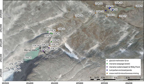
A total of 28 point locations were sampled for temperature and isotopic composition within the study area, focussing on the glacier front, the ice-cored moraine and related meltwater ponds, and the area around Leirpullan (). For liquid samples, in situ temperature was measured using a handheld thermometer. All samples were collected manually in sterile polypropylene bottles. Ice samples were packed into airtight plastic bags and allowed to melt slowly and naturally melt before being decanted to bottles and then stored in cold and dark conditions. Processing of all liquid stable isotope samples was carried out at the Norwegian National Infrastructure project FARLAB (Facility for advanced isotopic research and monitoring of weather, climate, and biogeochemical cycling). Sampling sites cover the spectrum of surface waters, including streams and standing waters, bare glacial ice and buried ice and an abundance of locations where water emerged from the subsurface along the distal side of the marginal moraine. Three water samples were taken of the enclosed, disconnected ponds on the Leirpullan frost mounds as well as one semi-connected pond.
Figure 2. Location of water samples. Location of the sinkhole feature ‘Barrel Hole’ and the perennial lake ‘Milky Pond’ as indicated. Background image provided by Kartverket Geovekst og kommuner - Geodata AS (Citation2016).
The ratio of heavy to light isotopes may be indicative of the origin of the water, due to different exposures to fractionation processes (e.g. Gat and Gonfiantini Citation1981; Moser and Stichler Citation1988; Haldorsen et al. Citation1997; Kendall et al. Citation2014; Yde et al. Citation2016). While most studies using stable isotopes in catchment hydrology are based on temporal (i.e. seasonal) dynamics in isotope fractionation (Kumar et al. Citation2018), a few recent works show the potential of solely spatial analysis and provenance identification of stable isotopes in water (Wu et al. Citation2016; Florea et al. Citation2017; Sodemann et al. Citation2018). The record of modern-day isotopic composition in precipitation for Norway is sparse and extrapolation may be precarious in view of the strong gradients in altitude, continentality and latitudes of the mainland. The only long-term GNIP (Global Networks of Isotopes in Precipitation) monitoring station is located at Lista, on the southernmost coast of Norway. Extrapolated GNIP values (IAEA/WMO Citation2011) suggest mean annual δ18O to be 11.3‰.
Results
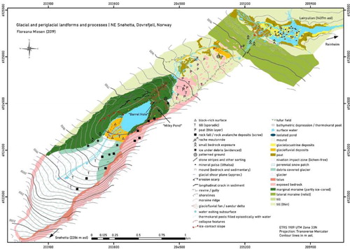
Key landform relevant to this study include the polythermal glacier, the proglacial lake, the ice-cored moraine complex as well as the network of meltwater channels as proxies of the connectivity between glacial and periglacial hydrology ().
Figure 3. Map of the glacial and periglacial landforms and processes at NE Snøhetta, Dovrefjell, Norway.
The polythermal glacier
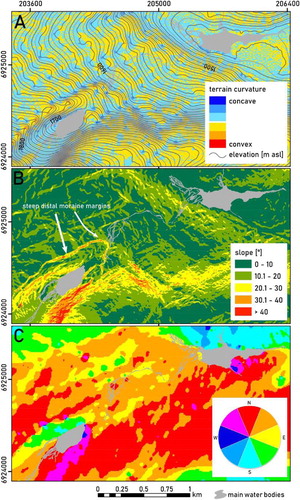
While the upper margin of the glacier is quite steep, the lower area of the glacier shows a concave surface structure with central parts at less than 20° (). The lower area is marked by debris covered parts on both sides of the glacier showing characteristic features of ice-sediment interaction, such as dirt cones and preferential melting around large boulders with a lower albedo than the surrounding ice and snow (Swithinbank Citation1950). The lower part of the glacier as well as the proglacial area extending to the northern outlet of the proglacial lake are further strongly impacted by shading from the adjacent Snøhetta massif to the south-east. Average air temperature at the mean altitude of the glacier in the study area was estimated to be −4.9°C. Temperatures rarely exceed 10°C during summer months and occasionally reach minimum values below −20°C. In view of predominant south-westerly winds, enhanced by katabatic winds, these well-shaded areas further provide spacious areas for the accumulation of snow in leeward direction, which is preserved throughout the years and progressively allows the formation of névés, as suggested by an observed paucity of lichen cover. Air temperatures during summer 2018 were notably higher than in 2013 and 2017 and likely explain the lack of expected perennial snow patches at these sites during the field visit. The only snow patch present at the time of observation was located adjacent to the distal eastern front of the marginal moraine.
Figure 4. Surface analysis of the study area. (A) Surface curvature, (B) Terrain curvature, (C) Terrain aspect. Calculated from ArcticDEM (Porter et al. Citation2018).
The proglacial lake
The proglacial takes on a prominent position in the study area between the glacier margin and the surrounding ice-cored moraine complex as well as the steep bedrock to the east ().
Field observations
On 5th September 2018 several water-free collapse features extending from the lower shore of the lake to the lower end of the moraine were observed. Bottom levels of the collapse features were found to be lower along the altitudinal gradient and distance from the lake. On 6th September, however, the collapse features near the lake shore suddenly started to fill up with water and water was eventually flowing from the lake to the new ponds. Drainage of the ponds into the subsurface of the marginal moraine was noted for several ponds. This contrast was strongest for Barrel Hole. At the eastern part of the marginal moraine complex, ice was found underneath the boulders at the moraine front. Additionally, a likely perennial thaw lake (‘Milky Pond’) was found on a high-elevation ridge of this part of the moraine (see ).
Remote sensing observations
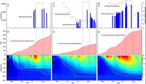
Semi-automated extraction of the lake surface from satellite imagery in 2013, 2017 and 2018 shows a seasonal pattern in surface area size (). Lake size appears to gradually increase in spring and early summer until approximately late July or early August before gradually decreasing throughout late summer and autumn.
Changes in lake surface area differ between years. The largest lake surface area identified from all available satellite imagery scenes was roughly 0.055 km2 in late July 2018, while the smallest was roughly 0.04 km2 in mid July 2017. However, a large variability in extracted area values is observed for all of July 2017. Available data further show a significantly earlier increase in area in 2018 compared to 2017. For mid-July, both 2018 and 2013 data suggest a lake surface area of roughly 0.05 km2 compared to less than 0.045 km2 in 2017. Initial lake surface area in winter cannot be determined as satellite imagery was only available after the onset of positive air temperatures, i.e. the start of the melt season. The timing of a change from increasing to decreasing surface area and an assumed onset of lake drainage in 2018 appears to be slightly earlier (most likely late July) compared to 2013 and 2017 (early to mid-August).
Multi-temporal analysis of lake coverage suggests that maximum extents are very limited in time (). This implies a rapid turn towards decreasing lake surface area after reaching a maximum value (see example of 2018).
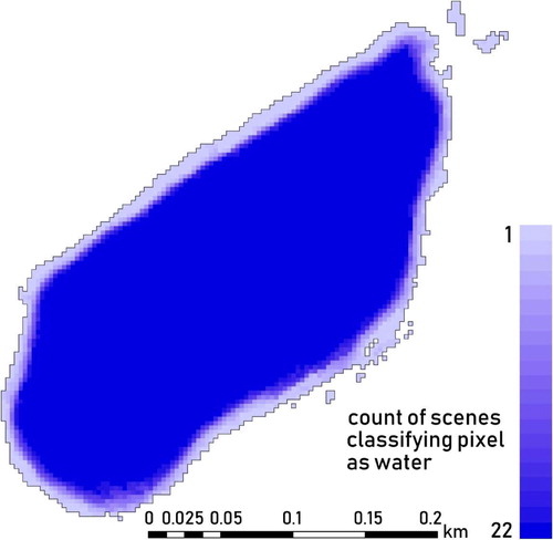
Figure 5. Lake surface area variability during melt season of 2018. Pixel colour shows count of PlanetScope scenes where semi-automated NDWI-calculation resulted in a classification as surface water. Note artefacts along SW shore are most likely produced by strong shading in satellite images. Based on data from planet.com.
InSAR data on surface elevation changes from Barrel Hole in 2017 and 2018 show a general vertical downward movement at the millimetre scale throughout the melt season and a notable increase in subsidence coinciding with the assumed lake drainage (). This effect is most pronounced for 2018.
Seasonal temperature evolution and lake fluctuations
Assuming that the proglacial lake is primarily fed by glacial meltwater and hence to assess the role of the glacier in controlling lake size, the number of positive degree days (PDD) as inferred from the available air temperature records extrapolated to the glacier were of interest (, panels B). 2017 shows the lowest summer air temperatures, with recurring periods of temperatures below freezing as suggested by various stagnations in the slope of positive degree days. The largest slope in PDD and hence increase in temperatures is observed in the second half of July. This coincides with a rapid increase in lake surface area. PDD slope then successively decreases over the remaining summer months, suggesting a decrease in absolute temperatures until it finally ceases in the first half of September. Total PDD of the study period 2017 was calculated to be 267.3°C (study period = 1 May to 10 September). This is significantly lower than the total PDD in 2018 (643.2°C) and 2013 (497.2°C). 2018 and 2013 additionally show more continuous development of PDD. 2013 air temperatures appear to steadily increase from mid-June to September, with short periods of sub-freezing temperatures in mid and late August, when PDD stagnates. 2018 records show the steepest slope in PDD. After an initial rapid increase in air temperatures throughout May, June marks an approximately two-week period of very low to sub-freezing temperatures (as suggested by a stagnation in PDD slope) before transitioning to a warm period of fairly consistent temperatures as suggested by a uniform slope in PDD. Throughout August, PDD slope decreases, indicative of a drop in air temperatures to sub-freezing conditions. In summary, the results imply a long period of intense melt in 2018.
Figure 6. Melt season dynamics in 2013 (I), 2017 (II) and 2018 (II). (A) Lake surface area detected by NDWI from RapidEye (I) and PlanetScope (II, III) imagery and surface displacement near Barrel Hole according to InSAR (II, III), (B) positive degree days and (C) ground thermal profile at DB1 (I), DB2 (II, III). Based on data from planet.com, insar.ngu.no, eklima.met.no and GTN-P.
The ice-cored moraine
Moraine morphology
Proglacial deposition is most clearly expressed by the large disconnected marginal moraine consisting of unsorted sediments dominated by blocks. Gelifluction lobes and jacked boulders produced by cryoturbation were found on the moraine surface. The distal part of the marginal moraine is marked by steep slopes, locally exceeding angles of 40° ().
The marginal moraine shows a distinct division into two lobe-shaped units (). Unit I reflects the larger part of the moraine, making up the western shore of the proglacial lake and stretching down valley in extension of the proglacial lake outlet. While the difference in elevation between the lake surface and the moraine ridge is most pronounced in the westernmost part of Unit I, a distinctively lowered area stands out stretching from the lake outlet towards the distal northeastern moraine front. Here, numerous crater-like collapse features were observed as well as an overall lack of lichen-cover on the till. Unit II encompasses the southeastern part of the moraine. The margin between the two units is marked by a strong step in the relief from the flat area of Unit I to a steep slope up to the ridge of Unit II. In contrast to the fairly flat central part of Unit I, Unit II is nested in bedrock terrain, and steep valley flanks to the southeast. Its surface is strongly interspersed with numerous ridges and furrows. However, the substrate of the central part of Unit II stands out by an abundance of lichens on boulders. In contrast, the southernmost part of Unit II is characterised by a large scale collapse feature with strong contrasts in the relief and a heterogeneous occurrence of lichen-covered and lichen-free boulders. Available InSAR data from the frontal part of the marginal moraine further reveal an overall subsidence of the moraine surface of up to 1 cm since 2015 (). Areas close to the lake outlet and within the before mentioned corridor between the two parts of the moraine show a pronounced lowering of several centimetres per year. This includes the studied sinkhole feature adjacent to Barrel Hole and reflects the observations regarding the morphology illustrated in .
Figure 7. Sketch of the marginal moraine topography.
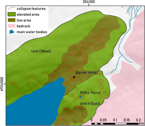
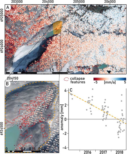
Figure 8. InSAR analysis of vertical surface movement at the marginal moraine. Left: Spatial distribution of mean vertical ground movement (mm/a). Note that colour scale applies to range between −5 and 5 mm/a, while some datapoints lie outside this range. Right: Deviation from mean vertical ground movement averaged for the frontal part of the marginal moraine (as indicated by orange dashed polygon on map). Linear regression indicated by orange dashed line. Sentinel 1-based InSAR data processing by Norges Geologiske Undersøkelse (Citation2018). Background image of map provided by Kartverket Geovekst og kommuner - Geodata AS (Citation2016).
Ground thermal regime and impact on lake levels
To assess the role of the ice-cored moraine in the seasonal drainage of the proglacial lake, its ground thermal regime was studied and inferred from the nearby borehole data (, panels C). DB1 and DB2 suggest an annual maximum active layer depth of approximately 480–520 cm. Overall, colder conditions and a temporal lag of the thermal regime in the marginal moraine (with reference to Snøheim) have to be expected because of higher elevations and difference in slope aspect of the study area. However, some specific seasonal patterns can be detected and may suggest conditions in the marginal moraine. Most notably, both DB1 and DB2 appear to be completely snow-free during all three study periods as near-surface ground temperatures clearly reflect fluctuations in measured air temperatures (periods of steep PDD slopes coincide with high ground temperatures at shallow depth). However, the atmospheric temperature signals appear to penetrate to greater depth with a temporal lag of several days to weeks.
The ground thermal profile of DB1 in 2013 (, panel I–C) shows a deepening of the active layer to approximately 360 cm until late June and a period followed by stagnation, or rather slow increase in the active layer, until a sudden increase in mid-August, where the active layer rapidly assumes its presumably final annual maximum depth of roughly 480 cm. It may be suggested that the timing of the lake drainage coincides approximately with this sudden deepening in the active layer. A lack of data points, however, impedes the verification of this hypothesis. The fairly rapid penetration of above freezing temperatures in the upper part of the depth profile and the subsequent two-month long stagnation of temperatures at a fixed depth is a recurring annual pattern at DB1. It suggests a stratification of the ground in an upper layer with high thermal conductivity above an ice-rich layer, with the latter producing a zero curtain during periods where latent energy is consumed by melting of ground ice instead of further penetration of sensible heat to greater depth (Outcalt et al. Citation1990). Once this ice-rich layer is thawed, the 0°C-isotherm may drop deeper until the maximum depth of the active layer is obtained. This suggests a fairly long period of temperatures just below 0°C at 370 cm depth, and then a sudden crossing of the freezing point in early August.
In 2017, the maximum depth of the 0°C-isotherm at DB2 (, panel II–C) is reached in early July, where it remains at approximately 520 cm for the rest of the melt season. The ground substrate at DB2 appears to have a high thermal conductivity as temperatures penetrate fairly rapidly to greater depth. This does not coincide with the initiation of lake drainage sometime in early August as suggested by the extracted lake surface areas. In view of the low air temperatures and thus PDD throughout the season, an overflow of the lake when a sufficient active layer thickness is reached was probably impeded by a lack of water inflow from glacial melt. Albeit conduits within the moraine may have been unblocked early in the season, the water level in the lake is suggested to have been too low to initiate overflow drainage.
Compared to the previous year, in 2018 the maximum depth of the active layer is reached slightly later, although the 0°C-isotherm penetrates the ground profile to greater depth earlier than in 2017 (, panel III–C). Assuming a slight temporal lag of the ground thermal regime within the marginal moraine behind that of DB2, a temporary period with a maximum active layer thickness of 500 cm from mid-July to early August is suggested to coincide with the timing of lake drainage. Mid-August marks a second drop of the 0°C-isotherm to slightly greater depth, suggesting an increase in active layer thickness as a lagged response to the exceptionally warm air and thus near-surface temperatures throughout July. In contrast to the dynamics in 2017, where the threshold of active layer thickness was reached before the threshold of meltwater input to initiate lake overflow, persistent warm air temperatures seem to have allowed a rapid increase in the surface area of the lake in 2018. However, early lake drainage was impeded by a not yet sufficiently thick enough active layer. As soon as the specific threshold in active layer thickness was crossed, lake drainage was likely initiated.
Distal glacier foreland
Beyond the marginal moraine, the study area extends into fairly flat (mostly less than 10°) terrain to the north-east, until reaching a step in the relief marked by the relict marginal moraine. With notably most steep slopes exposed towards north, these areas lack incoming solar radiation compared to flat areas throughout summer.
A key difference to the area upstream is the presumable smaller abundance of ground ice and associated landforms in the thin substrate. Features formed by present proglacial deposition include glaciofluvial sediments in sandur deltas and other outwash zones. As cryoturbation is rather ineffective in thin substrate, only a few, small periglacial features including small earth patches were found beyond the marginal moraine. In situ weathering impacts on bedrock and large boulders by frost action were more abundant. Field observations from 2018 confirmed previous accounts of various stages of degradation among the perennial frost mounds in the river-lake.
Assessing hydrological connections within the glacier foreland
Surface waters are largely connected and play a significant role in the erosion and deposition of sediments in the study area. At the distal side of the moraine, several meltwater springs emerging from the subsurface of the moraine display an area of numerous braided meltwater channels (). Some confluence is seen in a concentration of channels along the western side of the study area. Glaciofluvial deposits become generally more fine-grained from the glacier towards Leirpullan.
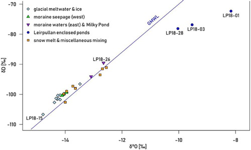
To complement the field mapping of surface water, isotopic signatures are used as tracers to establish sub-surface hydrological connections, and origins of water. With increasing distance from the glacier and decreasing elevation, water samples show overall trends in all parameters assessed. Heavy isotopes (18O and D) become generally less depleted towards lower elevations. Sampled stable oxygen isotope ratios δ18O ranged from −14.78 to −8.16‰ with a mean value of −13.31‰. Ratios of the stable hydrogen isotope (deuterium) δD ranged from −106.7 to −72.32‰ with a mean ratio of −96.2‰ all according to V-SMOW. Correlation of δ18O and δD shows a good fit along the GMWL with an overall tendency of placement above the standard ratio (). However, samples from the enclosed ponds on the frost mounds of Leirpullan (LP18-01, LP18-03 and LP18-28) are located well below the GMWL and are likely placed along a local meteoric water line. Apart from these distinct outliers, water from the so-called Milky Pond (LP18-26) shows the least amount of depletion both in 18O and D; whereas ice from the debris covered part of the glacier (LP18-15) shows the strongest depletion. Glacial meltwaters are generally more depleted in heavy isotopes than waters from other sources. Waters also become enriched in heavy isotopes with distance from the initial discharge of glacial meltwater.
Figure 9. Correlation of δ18O and δD along the GMWD. Note outliers marked in dark blue (LP18-01, LP18-03, LP18-28) corresponding to samples from enclosed ponds at Leirpullan; ice from debris-covered glacier (LP18-15) marked in light blue; water from Milky Pond (LP18-26) on eastern part of moraine marked in purple.
Acknowledging possible bias due to non-uniform sampling and potential diurnal variability, measured water temperatures show a large variability, ranging from 0°C to 11.1°C, and averaging 5.03°C. In the upper part of the study area, glacial meltwater appears to warm after entering the moraine dammed proglacial lake and shows a clear increase in temperature at the outlet towards the marginal moraine (LP18-07 and LP18-08). An inverse altitudinal gradient is then noted comparing the temperature of water presumably entering the subsurface of the marginal moraine to the lower temperature of water exiting the subsurface at the distal side of the moraine.
Discussion – transitional landforms in a glacial-periglacial landscape
Landscape scale – the landscape continuum
The study area comprises a landform assemblage typical for Norway. Formerly glaciated terrain is reworked by present day processes, producing a geomorphic palimpsest (Hewitt Citation2002). Long-term adjustment occurs simultaneously to processes triggered by recent disturbances which produce transitional landforms such as ice-cored moraines. The entire landscape appears to be exposed to a shared general forcing (Deline et al. Citation2015), driving large permafrost degradation and changes in glacier extent and geometry.
A clear overlap of various process domains along elevation can be observed within the study area (), challenging a definite distinction of classical altitudinal belts (cf. Kerguillec et al. Citation2015; Kerguillec and Sellier Citation2021) and suggesting a high relevance of transitional patterns in a landscape continuum (Giardino and Vitek Citation1988).
Figure 10. Density distribution of process domains by elevation as derived from a classification of mapped geomorphic landforms.
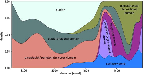
In the upper parts of the study area, landforms allocated to the glacial erosional domain dominate along the glacier margin. Oversteepened rock-faces are impacted both by paraglacial processes grounded in the loss of glacial overburden and periglacial processes exerting frost weathering on the bedrock at different rates, creating an assemblage of paraglacial subsystems (cf. Mancini and Lane Citation2020). Talus slopes are abundant and indicative of a glacial-periglacial transition zone extending to lower elevations.
The proglacial area marks the appearance of the glacial depositional domain, mostly implemented by glaciofluvial processes producing landforms such as outwash deltas. However, there is no clear spatial boundary between the glacial erosional and depositional domains again suggesting the presence of various subsystems of land surface change.
The periglacial domain outside the glacier margins (which is separate from the paraglacial domain) dominates in the lower parts of the study area and is prominent in the area including the ice-cored moraine and the proglacial lake, and in the Leirpullan area. Notably these areas show a nesting of the periglacial degradational domain, referring to the occurrence of thermokarst landforms such as collapse features in former ice-rich sediment or the degraded frost mounds. Landforms emerging from the degradation of permafrost and related morphometric readjustment processes may also be considered paraperiglacial as suggested by Mercier (Citation2008).
Morphological differences between the upper, actively glaciated area, and the lower part of the study area further reveal heterogeneity in process domains. The gradient from predominantly concave, to rather even, to convex terrain reflects the spatial concentration of active glacial erosional processes in the upper study area and a shift to predominantly depositional processes in the lower parts. InSAR data confirms this by revealing predominantly subsidence in the upper area against surface rise in the lower areas.
The lowest area, such as Leirpullan appears to have completed the transition towards the periglacial domain and is currently in the process of a secondary transition to a domain beyond periglaciation. In fact, Leirpullan constitutes an environment of various glacial and periglacial imprints, likely of different age and activity compared to the upper part of the study area. Other studies have shown that the frost mounds at Leirpullan are indicative of sporadic permafrost (Matthews et al. Citation1997; Sollid and Sørbel Citation1998; Hofgaard and Myklebost Citation2018). However, the occurrence of thufurs along the margins might show a transition towards a domain that is no longer dominated by permafrost but rather dependent on seasonal frost cycles (Harris Citation1988). Water from the enclosed thaw ponds likely originates from a mixture of meltwater from old ground ice (i.e. ice lenses in frost mounds originating from groundwater), liquid precipitation and snow melt. This is supported by distinct signatures in δ18O ratios that differ strongly from all other samples in the hydraulically connected system (of flowing waters). Leirpullan samples appear to be enriched in δ18O and δD and deviate from the GMWL. Their own local meteoric water line would have a lower slope and a lower y-intercept, indicative of a lower d-excess. These observations suggest that the standing water at Leirpullan is controlled by local environmental conditions that are decoupled from the rest of the catchment. From a space-for-time-substitutional perspective, this implies that post-transitional conditions leading to landforms as currently found at Leirpullan must be expected to propagate upstream.
Landform scale – ice-cored moraines and proglacial lakes as key transitional components
Like many ice-cored moraines, the marginal moraine at Snøhetta shows especially high rates of transformational activity (Ewertowski and Tomczyk Citation2015). Slumping and other processes are indicative of a not yet completed degradation of the ice core. For instance, different isotopic signatures at the small stream outlets of the moraine suggest a mixing of direct glacial meltwater with other sources, e.g. meltwater from the ice core, which may be old glacial ice or ice from snow compaction (cf. Brown et al. Citation2006; Roy and Hayashi Citation2009). The slight deviations in isotope signal may also point to a delayed discharge and an intermediate storage function of the moraine. A distinct drop in temperature of water seeping from the distal side of the moraine in comparison to the lake outlet above further suggests that glacial meltwater is mixed with meltwater from the ice core. However, cooling will also occur from latent heat consumption as the liquid water melts the ice.
Transitional moraine morphology
The western segment of the moraine appears to show more degradational activity than its eastern counterpart, most dominantly inferred from the differences in lichen cover. The marginal steep valley side to the east promotes shading and shields this part of the moraine from solar radiation, compared to the western part which is more exposed. Topographic shading has been observed to play a significant role in the spatial distribution of downwasting intensities of ice-cored moraines (Lyså and Lønne Citation2001; Tonkin et al. Citation2016). An overall cooler local climate likely explains the occurrence of ice close to the surface at the frontal slope. The perennial Milky Pond suggests an impermeable layer and a generally less elaborated internal network of aquifers, inhibiting its drainage. This part of the moraine may also be more exposed to a longer snow cover in spring. In contrast, the western part is more exposed to wind removal of the insulating snow layer which would otherwise preserve the cold near-surface temperatures until summer and lower the effect of atmospheric forcing on the ground thermal regime (e.g. Stieglitz et al. Citation2003).
Downwasting rates in the western segment of the ice-cored moraine as inferred from the InSAR dataset are still fairly low, compared to other ice-cored moraines found in a more advanced degradational state in other climatic zones (e.g. Krüger et al. Citation2010). However, a general downward trend with localised concentration of larger values reveals the interplay of homogeneous downwasting versus rapid backwasting in preferential sinkholes. Gradual lowering of the surface is indicative of a horizontal melting front controlled by the penetration of warm air temperatures and internal meltwater films (cf. Krüger and Kjær Citation2000). Moreover, variability in area averaged data may represent seasonal active layer dynamics. Subsidence throughout the melt season is partly explained by seasonal loss in volume from pore ice in the active layer. Long-term downwasting from degradation of the ice core is partly compensated by winter ground heave as the pore ice refreezes in the active layer. Moreover, some sinkholes may show vertical upward ground movement if sediment infill from slope wasting exceeds subsidence rate.
The observation of widespread occurrences of sinkholes, indicative of thermokarst, and localised high rates of surface subsidence (e.g. near Barrel Hole) inferred from InSAR data show that seasonally, backwasting appears to dominate the degradation of the ice-cored moraine. Additionally, the remotely sensed time series of the proglacial lake extent suggest that back wasting is likely controlled by the impact of the cyclic, partial drainage of the relatively warm lake water into the subsurface of the moraine during summer. Subsurface drainage appears to concentrate along the already established depressed areas of the moraine.
The eastern part appears to be largely decoupled from the main meltwater routes linking the lake water with the distal area of the moraine complex. The surficial lake outlet is clearly located in the western segment. Judging from the spatial distribution of elongated topographic lows, water is preferentially routed along a north-eastern axis from the lake outlet to the northernmost tip of the moraine front, as well as along the distinct ravine marking the border between the two moraine segments. Isotope samples from the eastern segment of the moraine are outliers and likely indicate that this part is decoupled from the general catchment system. Sampled buried ice and water from the perennial pond on this part of the moraine are more enriched in δ18O compared to the glacial ice and meltwater. A topographic bedrock threshold as well as the steep valley sides are suggested to direct groundwater flow to the topographically lower situated western part. Here thermal abrasion of the ice core by relatively warmer water may be concentrated, additionally explaining the differential degradation between the two moraine segments. Merely the part of the eastern moraine closest to the lake shore appears to be strongly impacted by degradation, as inferred from the large depression feature. This is likely due to the thermal influence of the lake which provides a heat source to the surrounding ground.
Lake drainage as a product of glacier-permafrost interaction
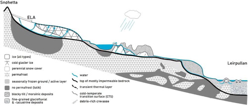
A summary of the discussed results regarding the study area’s hydrology based on sampled stable isotope signatures and ground thermal conditions during melt season is illustrated by a conceptual sketch map (). The longitudinal profile draws on the relationship of polythermal glaciers and permafrost as suggested by Pettersson (Citation2004), Etzelmüller and Hagen (Citation2005), Irvine-Fynn et al. (Citation2011) and Dobiński et al. (Citation2017) identifying a seamless junction of cold glacier ice and permafrost. In agreement with Richardson and Reynolds (Citation2000), Langston et al. (Citation2011) and McClymont et al. (Citation2011), water routeing through the ice-cored moraine occurs mainly along the interface of frozen and unfrozen ground. The sketch only applies to the western segment of the ice-cored moraine, showing the relevance of aquifers in the connectivity of meltwater routes within the catchment.
Figure 11. Conceptual model of the permafrost and ice distribution and the main meltwater routes in the study area. Only the western segment of the ice-cored moraine is displayed. Temperate glacier ice and the proglacial lake are underlain by taliks. Subsurface routeing in the ice-cored moraine takes place at the interface of the permeable substrate and the impermeable ice-core. Overflow of the proglacial lake may occur at sufficiently high lake levels. The relict moraine surrounding Leirpullan features both surface and subsurface routeing.
Although the precise timing of lake drainage initiation was not identifiable due to a lack of sufficiently dense satellite imagery, it appears to entail a clear dependency both on permafrost dynamics and on atmospheric condition controlling glacier melt. The lake surface area must reach a specific threshold in water level to exert sufficient hydrostatic pressure and to allow overflow into the moraine. However, the lake water cannot be drained before the active layer has reached a specific thickness. Only an unfrozen substrate allows the development of a subsurface drainage network along the permafrost table. If the lake volume has not risen sufficiently (e.g. due to a lack of PDD), however, water will not be routed downstream even if the active layer is thick enough. This suggests a hierarchy in thresholds with greater importance and role of the active layer threshold as a final control of drainage.
The particular environmental setting of the ice-cored moraine is quite distinct from that of DB1 and DB2 and presumably produces a different thermal regime. The local climatic setting must be expected to entail overall lower mean air temperatures, not only due to the location at a higher elevation, but also with regard to a NE aspect and strong topographic shading. Frequent katabatic winds from the glacier will have an additional cooling effect on the local climate at the ice-cored moraine. Furthermore, data from DB1 and DB2 show a strong response to air temperatures at the near sub-subsurface, even early in the melt season. This is likely explained by the slightly convex, wind-exposed location of the boreholes, where the insulation by snow cover will be weak. In contrast, the study area is located in a confined setting at the lee side of prevailing winds favouring a pronounced accumulation of snow that likely endures until late in the melt season. In view of these environmental conditions, the evolution of ground temperatures in the ice-cored moraine must be expected to lag behind those of DB1 and DB2. Maximum active layer depth is likely to be smaller and reached later. Additionally, it is possible that the snow cover protects the active layer until its removal evokes an abrupt relocation of the 0°C-isotherm from the surface to greater depth. This would support the observation of a narrow climax in lake surface area, rather than a gradual increase in outflow rates according to a successively increasing active layer depth over a longer period of time.
Processes leading to the seasonal partial drainage of the lake are obviously different from those observed to trigger glacial lake outburst floods (GLOFs) (Clague and Evans Citation2000; Emmer and Cochachin Citation2013; Falátková Citation2016; Chernomorets et al. Citation2018), which entail catastrophic breaching of the dam and an overflow which cause an almost complete erosion of a wide drainage incision into the moraine (Iturrizaga Citation2014). So far, such an impact cannot be inferred from the state of the studied moraine. Instead, different mechanisms appear to be at work, pointing to a generally less advanced degradation. Here, seasonality and thus dependency on atmospheric conditions clearly dictate a cyclicality of gradual erosion by regulated water outflow from the lake. It is likely that piping and subsurface flow are the primal processes evacuating water from the lake through the moraine. The abundance of seepages at the distal end of the moraine supports this assumption. Thermokarst depressions form due to locally pronounced melting of ground ice in addition to removal of sediment from the moraine by piping. The reduced temperature of water exiting the moraine in comparison to the lake outlet suggests that heat is advected by subsurface water, and that latent energy is consumed for melting, reducing the temperature of water.
It is unclear whether the disintegration of the moraine will continue in this gradual style of surface lowering, or whether a sudden outburst will occur in the near future. Piping and subsidence along with thermokarst development may gradually weaken the moraine dam up to a point where a comparatively low energy discharge event could cause a catastrophic breaching (Xu Citation1988; Clague and Evans Citation2000). In case of a GLOF, the sudden release of a large amount of water from the lake must be expected to have a significant impact on the downstream landscape and act as a strong agent of landscape transformation on a very short timescale (Iturrizaga Citation2014), as observed from other regions of the world (e.g. Cook et al. Citation2018).
It is evident that the drainage of the moraine-dammed lake is strongly dependent on the complex interaction of various environmental controls. The ice-cored moraine embodies a transitional landform and the legacy of a former climate and glacial extent. Originally built-up by glacial deposition, the ice-cored moraine now constitutes a permafrost environment. Importantly, as the definition of paraglaciation implies the recovery of a landscape from glacial disturbance, then the degrading ice-cored moraine cannot be considered a paraglacial landform, as it is still disturbed by glacial impact. This is enhanced by atmospheric forcing as a superordinate domain driving surface processes.
Role of water in glacier-permafrost interaction
It is evident that water provides an important link between the various studied landforms as suggested in . Even if spatially separated, the glacier still impacts landforms downstream by the export of meltwater, sediment and heat. In the realm of glacier-permafrost interaction, water serves three functional roles, which are hydraulic, thermal and mechanical.
The degree of hydraulic glacier-permafrost interaction is controlled by the abundance of aquifers in the subsurface (Williams and Smith Citation1989; Vitvar et al. Citation2005). In the present study, a hydraulic link between glacier and permafrost is most evident in the occurrence of frost mounds at Leirpullan, which, at periods of larger extents of glaciation, likely sourced their water for ice lens build-up from glacier-fed groundwater and shallow surface water (Vasil’chuk et al. Citation2015). Water travelling across the periglacial landscape provided an important moisture source at the surface and subsurface, aiding the build-up of ground ice (as suggested in ).
Thermally, water provides an agent of heat fluxes. It controls phases of surface and subsurface water, i.e. the transition from solid to liquid state and vice versa. Taliks develop where surface waters provide heat to the underlying ground (Harris and Corte Citation1992). Heat advection similarly takes place at the subsurface in localised channel networks within a relatively cold substrate. Energy is consumed by melt and thaw processes, directly impacting the water temperature. Thermokarst development is thus directly dependent on the dynamics of meltwater. Interestingly, the thermokarst processes taking place within the ice-cored moraine contrast those producing the melt ponds at Leirpullan. In the moraine, it is mainly the external input of warming water that evokes melting from below, whereas the frost mounds at Leirpullan are mostly impacted by warming atmospheric conditions, inducing melting primarily from above, and intrinsic melt processes, that might have a self-enforcing effect as warm internal meltwater promotes the further disintegration of the ice-lens.
Lastly, the mechanical impact of water in shaping transitional landforms is significant. Erosion, transport and deposition of sediment are thus directly controlled by water dynamics. In a glacial-periglacial landscape, this entails both the erosional and depositional function of glacial ice and the extensive mechanical functionalities of proglacial meltwater streams. Components of the landscape are therefore the legacy of the variability in the glacial and proglacial hydrological system. Storage of sediment may be short or long in time, representative of the wide range of timescales, on which transition takes place. At times, catastrophic processes in the hydrological system produce disproportionately rapid change, e.g. by GLOFs as discussed above.
The presented results highlight the relevance of external water input for the degradation of the ice-cored moraine. While many studies focus on the de-icing process as a function of internal melt processes or as a function of heat advection by internal meltwater, it is evident that external water input, e.g. from lake drainage or rain, will have a significant impact and accelerate the de-icing of moraine complexes. Additionally, we here suggest that this may be further enhanced by internal drainage that is itself related to proglacial lake development and the properties of the ice-marginal permafrost.
Outlook – towards a process domain beyond glaciation and periglaciation
As glaciers retreat, the proglacial area increases and constitutes a pattern of geomorphologically active, transitional landforms. Downstream areas are expectedly further advanced in the transition from a glacial to a non-glacial domain.
In high mountain areas, permafrost is expected to migrate to areas of glacial retreat (Harris and Murton Citation2005). An aggradation of permafrost at the glacier margin may delay geomorphic processes associated with the paraglacial period by temporarily preserving glacial landforms. A warming climate thus may thus have large consequences on landscape evolution where landforms are strongly changed by processes of a number of different domains (Kokelj et al. Citation2017).
Additionally, recent research (Reinardy et al. Citation2019) suggests that subglacial permafrost may be more common in the near future as thinning glaciers retreat to higher altitudes and might temporarily become polythermal. This may have significant impacts on the dynamics of groundwater generation in the ice-marginal zone. Retreating glaciers have also been observed to yield to growing proglacial lakes (Carrivick and Quincey Citation2014; Wang et al. Citation2015; Song et al. Citation2017). New lakes are expected to develop in deglaciated overdeepenings in former glacier beds (Bogen et al. Citation2015). In view of an expected degradation of permafrost extent, however, the long-term stability of these new lakes will be questionable, portending a pronounced activity of lake drainages in a rapidly changing climate.
Conclusions
The multi-methodological approach in the present study has proven useful in allowing insights into the transient nature of complex transitional glacial-periglacial landform patterns. The possible role of water in providing a hydraulic, thermal and mechanical connection between glaciers and permafrost has been highlighted. Furthermore, the degradation of the ice-cored moraine has been shown to occur in relation to the internal melt processes and to proglacial lake drainage.
Designed as an inductive pilot study, the presented results from NE Snøhetta provide a solid base for subsequent studies, aiming to understand landscape dynamics in a rapidly changing environment. Observing and quantifying the temporal concept of transience in a landscape provides a challenge to research. Spatial transitions can be observed however, and serve to infer the scope of transience in a landscape. At Snøhetta, the continuum of transitional landforms pertaining to several overlapping process domains suggest an ongoing temporal phase of landscape transience in response to changing environmental conditions. Many landforms show intermediate states impacted by glaciation, paraglaciation, periglaciation and paraperiglaciation. Many of these transitional landforms can be interpreted as responses to more than only one process regime and are heavily impacted by hydrological processes. Water is a key agent in shaping the rapid transitional nature of glacial-periglacial systems. Water routeing is responsible for nearly all elements in the transitional landform assemblage, as it exerts strong imprint by erosion, transportation and deposition, even at periods of full glaciation. Even when spatially separated, glaciers can still strongly influence the evolution of periglacial landforms through the export of water, sediment and heat.
The proglacial lake dammed by the degrading ice-cored moraine is here highlighted as a key transitional component. It is suggested that the timing of lake drainage is governed by a twofold threshold in a glacier-permafrost regime:
lake level rises to an overflow rim as controlled by glacial meltwater discharge
increase in active layer depth within the marginal moraine, unblocking subsurface water conduits.
As a possible consequence, the marginal moraine provides both a barrier and a pathway to meltwater exiting the glacier. The interaction between air and ground temperatures is critical in determining glacial ablation and active layer dynamics and plays a key role in directing the landform processes deriving from glacier-permafrost interaction.
Glacial meltwater is an important source for hydropower in Norway. The degradation of glacial and ground ice is thus likely to have socio-economic consequences, especially in summers. The presented results can help to understand glacier-permafrost transient landscapes where the risk of potentially catastrophic lake outbursts from moraine collapse is high and puts socio-economic assets at stake. It is thus of considerable urgency to detect current changes in the scope of cryospheric water and sediment reservoirs potentially available for hazardous processes.
Acknowledgements
Field work was conducted in September 2018. The authors would like to thank Birgitte Norheim and Matthew Jenkin for their assistance in the field. Handling and processing of all liquid stable isotope samples was carried out at the Norwegian National Infrastructure project FARLAB (Facility for advanced isotopic research and monitoring of weather, climate, and biogeochemical cycling) at the University of Bergen, Norway. Further data was kindly provided by PlanetScope (satellite imagery), eKlima (climate data) and Dr. Ketil Isaksen (GTN-P data). The authors are thankful to Dr. Rannveig Øvrevik Skoglund and to Dr. Benjamin Aubrey Robson for their comments and help with data acquisition, as well as to Dr. Richard Waller and other, anonymous reviewers for helpful comments on an earlier version of this paper.
Disclosure statement
No potential conflict of interest was reported by the author(s).
Additional information
Notes on contributors
Floreana Miesen
Floreana Miesen, MSc in geography, graduate of the University of Bonn. Her main research interest lies in studying cross-disciplinary feedbacks in Alpine and Arctic environmental systems with a focus on the seasonal dynamics of the cryosphere. She has contributed to projects in the Argentinean Andes, northern-central Chile, the European Alps and Svalbard. Since 2020, she is engaged as Junior Researcher in the lab of Prof. Dr. Stuart Lane at the University of Lausanne to study subglacial and proglacial sediment dynamics in the southern Swiss Alps.
Svein Olaf Dahl
Svein Olaf Dahl, Dr. scient, Professor in physical geography. He does research in physical geography, glacier-climate interaction, palaeoclimatology, geomorphology and quaternary geology focused on the Little Ice Age, the Holocene, last deglaciation and the Weichselian. Currently he works on the Late Weichselian and Holocene glacial environmental and climate history in northern Scandinavia and the ice-age history in the Rondane ‘dry valleys’, east-central southern Norway.
Lothar Schrott
Lothar Schrott, Dr.rer.nat., Professor in physical geography. His research focuses on alpine geomorphology, permafrost and periglacial processes, sediment fluxes and hydrology, mass movements, and natural hazards. One of his recent projects in the Andes identifies the spatial extent of permafrost and quantifies the hydrological significance of this cryospheric component. In the European Alps, he initiated a long term monitoring project to develop an expert system for unstable rock slopes. He is Director of a master programme on disaster management and risk government and services for several Journals as member of the editorial board.
References
- Allen P. 2005. Striking a chord. Nature. 434:961.
- Allen S, Owens I, Sirguey P. 2008. Satellite remote sensing procedures for glacial terrain analyses and hazard assessment in the Aoraki Mount Cook region, New Zealand. New Zealand J Geol Geophy. 51:73–87.
- Andreassen LM, Hausberg JE, Winsvold SH, Paul F. 2012. Inventory of Norwegian glaciers. Norwegian water resources and energy directorate.
- Astakhov VI, Isayeva LL. 1988. The ‘ice hill’: an example of ‘retarded deglaciation’ in Siberia. Quat Sci Rev. 7:29–40.
- Awal R, Nakagawa H, Kawaike K, Baba Y, Zhang H. 2011. Experimental study on piping failure of natural dam. J JSCE. 67:I_157–I_162.
- Ballantyne CK. 2002. Paraglacial geomorphology. Quat Sci Rev. 21:1935–2017.
- Bierman PR, Montgomery DR. 2014. Key concepts in geomorphology. New York, NY: Freeman; 121 p., ISBN: 9781429238601 .
- Bogen J. 1982. En fluvialgeomorphologisk undersøkelse av joravassdraget medbreområdet Snøhetta. Oslo: Rapport / Kontaktutvalget for vassdragsreguleringer, Universitetet i Oslo. 51.
- Bogen J, Xu M, Kennie P. 2015. The impact of pro-glacial lakes on downstream sediment delivery in Norway. Earth Surf Process Landforms. 40:942–952.
- Brown LE, Hannah DM, Milner AM, Soulsby C, Hodson AJ, Brewer MJ. 2006. Water source dynamics in a glacierized alpine river basin (Taillon-Gabiétous, French Pyrénées). Water Resour Res. 42:399.
- Carrivick JL, Quincey DJ. 2014. Progressive increase in number and volume of ice-marginal lakes on the western margin of the Greenland Ice Sheet. Glob Planet Change. 116:156–163.
- Carrivick JL, Tweed FS. 2013. Proglacial lakes: character, behaviour and geological importance. Quat Sci Rev. 78:34–52.
- Chernomorets S, Petrakov D, Aleynikov A, Bekkiev M, Viskhadzhieva K, Dokukin M, Kalov R, Kidyaeva V, Krylenko V, Krylenko I, et al. 2018. The outburst of Bashkara glacier lake (Central Caucasus, Russia). On September 1, 2017. EC. XXII.
- Church M, Gilbert R. 1975. Proglacial fluvial and lacustrine environments. In: Jopling AV, McDonald BC, editors. Glaciofluvial and glaciolacustrine sedimentation. GeoScienceWorld; p. 22–100 (SEPM special publication; vol. 23).
- Church M, Ryder J. 1972. Paraglacial sedimentation: a consideration of fluvial processes conditioned by glaciation. Geol Soc America Bull. 83:3059.
- Clague J, Evans S. 2000. A review of catastrophic drainage of moraine-dammed lakes in British Columbia. Quat Sci Rev. 19:1763–1783.
- Cook KL, Andermann C, Gimbert F, Adhikari BR, Hovius N. 2018. Glacial lake outburst floods as drivers of fluvial erosion in the Himalaya. Science. 362:53–57.
- Cooley S, Smith L, Stepan L, Mascaro J. 2017. Tracking dynamic northern surface water changes with high-frequency planet CubeSat imagery. Remote Sens (Basel). 9:1306.
- Cooper R, Hodgkins R, Wadham J, Tranter M. 2011. The hydrology of the proglacial zone of a high-arctic glacier (Finsterwalderbreen, Svalbard): Sub-surface water fluxes and complete water budget. J Hydrol. 406:88–96.
- Dahl SO, Nesje A. 1992. Paleoclimatic implications based on equilibrium-line altitude depressions of reconstructed Younger Dryas and Holocene cirque glaciers in inner Nordfjord, western Norway. Palaeogeogr Palaeoclimatol Palaeoecol. 94:87–97.
- Deline P, Gruber S, Delaloye R, Fischer L, Geertsema M, Giardino M, Hasler A, Kirkbride M, Krautblatter M, Magnin F, et al. 2015. Ice loss and slope stability in high-mountain regions. In: Haeberli W, Whiteman CA, Shroder JF, editor. Snow and ice-related hazards, risks and disasters. Amsterdam, Boston, Heidelberg: Elsevier; p. 521–561. (Hazards and disasters series).
- Dobiński W, Grabiec M, Gadek B. 2011. Spatial relationship in interaction between glacier and permafrost in different mountainous environments of high and mid latitudes, based on GPR research. Geolog Quater. 55:375–388.
- Dobiński W, Grabiec M, Glazer M. 2017. Cold–temperate transition surface and permafrost base (CTS-PB) as an environmental axis in glacier–permafrost relationship, based on research carried out on the Storglaciären and its forefield, northern Sweden. Quat Res. 88:551–569.
- Driscoll FG. 1980. Wastage of the Klutlan Ice-Cored Moraines, Yukon Territory, Canada. Quat Res. 14:31–49.
- Dyke AS, Evans DJA. 2003. Ice-marginal terrestrial landsystems: Northern Laurentide and Innuitian ice sheet margins. In: Glooster L, Evans D, editors. Glacial landsystems. p. 143–163.
- Emmer A, Cochachin A. 2013. The causes and mechanisms of moraine-dammed lake failures in the Cordillera Blanca. North American Cordillera, and Himalayas. AUC GEOGRAPHICA. 48:5–15.
- Etzelmüller B, Hagen JO. 2005. Glacier-permafrost interaction in Arctic and alpine mountain environments with examples form southern Norway and Svalbard. In: Harris C, Murton J, editors. Cryospheric systems: Glaciers and permafrost. p. 11–27 (Geological Society special publication; vol. 242).
- Etzelmüller B, Hagen JO, Vatne G, Ødegård RS, Sollid JL. 1996. Glacier debris accumulation and sediment deformation influenced by permafrost: examples from Svalbard. Ann Glaciol. 22:53–62.
- Ewertowski MW, Tomczyk AM. 2015. Quantification of the ice-cored moraines’ short-term dynamics in the high-Arctic glaciers Ebbabreen and Ragnarbreen, Petuniabukta. Svalbard Geomorphol. 234:211–227.
- Eyles N. 1979. Facies of supraglacial sedimentation on Icelandic and Alpine temperate glaciers. Can J Earth Sci. 16:1341–1361.
- Falátková K. 2016. Temporal analysis of GLOFs in high-mountain regions of Asia and assessment of their causes. AUC GEOGRAPHICA. 51:145–154.
- Florea L, Bird B, Lau JK, Wang L, Lei Y, Yao T, Thompson LG. 2017. Stable isotopes of river water and groundwater along altitudinal gradients in the high Himalayas and the Eastern Nyainqentanghla mountains. J Hydrol Reg Stud. 14:37–48.
- Follestad B. 2003. Snøhetta 1519 IV. Kvartærgeologisk kart. Trondheim: Norges geologiske Undersøkelse (NGU).
- Gat JR, Gonfiantini R, editors. 1981. Stable isotope hydrology. Deuterium and oxygen-18 in the water cycle. Vienna: Internat. Atomic Energy Agency. 33724 p. (Technical reports series / International Atomic Energy Agency; No. 210). ISBN: 92-0-145281-0 .
- Geilhausen M, Otto J-C, Morche D, Schrott L. 2012. Decadal sediment yield from an Alpine proglacial zone inferred from reservoir sedimentation (Pasterze, Hohe Tauern, Austria). IAHS Redbook on Erosion and Sediment Yields Chang Environ. 356:161–171.
- Giardino JR, Vitek JD. 1988. The significance of rock glaciers in the glacial-periglacial landscape continuum. J Quater Sci. 3:97–103.
- Haldorsen S, Riise G, Swensen B, Sletten R. 1997. Environmental isotopes as tracers in catchments. In: Saether OM, Caritat P de, editor. Geochemical processes, weathering and groundwater recharge in catchments. Rotterdam: Balkema; p. 185–210.
- Harris SA. 1988. The alpine periglacial zone. In: Clark M, editor. Advances in periglacial geomorphology. Chichester: John Wiley & Sons Ltd; p. 369–413.
- Harris SA, Corte AE. 1992. Interactions and relations between mountain permafrost, glaciers, snow and water. Permafrost and Periglac Process. 3:103–110.
- Harris C, Murton J. 2005. Interactions between glaciers and permafrost: an introduction. In: Harris C, Murton J, editors. Cryospheric systems: Glaciers and permafrost; p. 1–9 (Geological Society special publication; vol. 242).
- Heckmann T, McColl S, Morche D. 2016. Retreating ice: research in pro-glacial areas matters. Earth Surf Process Landforms. 41:271–276.
- Hewitt K. 2002. Introduction: landscape assemblages and transition in cold regions. In: Hewitt K, Byrne M-L, English M, Young G, editor. Landscapes of transition. Landform assemblages and transformations in cold regions. Dordrecht: Springer Netherlands; p. 1–8. (The GeoJournal Library).
- Hock R. 2003. Temperature index melt modelling in mountain areas. J Hydrol. 282:104–115.
- Hoffmann T. 2015. Sediment residence time and connectivity in non-equilibrium and transient geomorphic systems. Earth Sci Rev. 150:609–627.
- Hofgaard A. 2008. Overvåking av palsmyr. Førstegangsundersøkelse i Leirpullan, Sør-Trøndelag 2007. NINA Rapport 364. [place unknown]: Norsk institutt for naturforskning.
- Hofgaard A. 2009. Norwegian monitoring program for palsa peatlands. Reports of Finnish Environ Inst. 3:15–16.
- Hofgaard A, Myklebost H. 2018. Andre gjenanalyse i Leirpullan, Dovrefjell i Trøndelag. Endringer fra 2007 til 2017. NINA Rapport 1510. Norsk institutt for naturforskning.
- Hughes T. 1973. Glacial permafrost and Pleistocene ice ages. In: Permafrost: Second International Conference. North American contribution. Washington, DC, National Academy of Sciences, p. 213–223.
- IAEA/WMO. 2011. Global Network of Isotopes in Precipitation. The GNIP Database. Available from: https://www.iaea.org/water.
- Irvine-Fynn TDL, Hodson AJ, Moorman BJ, Vatne G, Hubbard AL. 2011. Polythermal glacier hydrology: A review. Rev Geophys. 49:95.
- Isaksen K, Hauck C, Gudevang E, Ødegård RS, Sollid JL. 2002. Mountain permafrost distribution in Dovrefjell and Jotunheimen, southern Norway, based on BTS and DC resistivity tomography data. Norsk Geogr Tidsskrift – Norwegian J Geogr. 56:122–136.
- Isaksen K, Ødegård RS, Etzelmüller B, Hilbich C, Hauck C, Farbrot H, Eiken T, Hygen HO, Hipp TF. 2011. Degrading mountain permafrost in southern Norway: spatial and temporal variability of mean ground temperatures, 1999–2009. Permafrost and Periglac Process. 22:361–377.
- Isaksen K, Sollid J. 2002. Løsavleiringer og permafrost i Hjerkinn skytefelt, Dovrefjell. Rapport. Universitet i Oslo. Available from: https://www.forsvarsbygg.no/contentassets/aa1a299ae7634a3bbb8bf8df785e581b/losmassegeologi-hjerkinn.pdf.
- Iturrizaga L. 2014. Glacier lake outburst floods. In: Singh VP, Singh P, Haritashya UK, editor. Encyclopedia of snow, ice and glaciers. 1st ed. New York [New York], Boston, Massachusetts: Springer; Credo Reference; p. 381–399 (Encyclopedia of earth sciences series).
- Jóhannesson T, Sigurdsson O, Laumann T, Kennett M. 1995. Degree-day glacier mass-balance modelling with applications to glaciers in Iceland, Norway and Greenland. J Glaciol. 41:345–358.
- Kartverket Geovekst og kommuner - Geodata AS, cartographer. 2009. Omløp Nord Østlandet 2009 – Hedmark Nord 2009. Available from: https://norgeibilder.no/.
- Kartverket Geovekst og kommuner - Geodata AS, cartographer. 2014. Omløpsfoto Trøndelag 2014. Available from: https://norgeibilder.no/.
- Kartverket Geovekst og kommuner - Geodata AS, cartographer. 2016. Omløpsfoto Hedmark-Nord 2016 GSD25. Available from: https://norgeibilder.no/.
- Kendall C, Doctos D, Young M. 2014. Environmental isotope applications in hydrological studies. In: Holland HD, editor. Treatise on geochemistry. 2nd ed. Amsterdam: Elsevier; p. 273–327.
- Kerguillec R. 2011. Étagements périglaciaires fonctionnels dans les massifs du Dovrefjell et des Rondane (Norvège centrale, 62°22’N/61°46’N; 8°5E/10°E): les enseignements du terrain. Environ Périglaciaires. 17:45–65.
- Kerguillec R. 2013. Les dynamiques périglaciaires actuelles dans un milieu de haute montagne atlantique: parcs nationaux du Oppland et du Sør-Trøndelag, Norvège centrale.
- Kerguillec R. 2014a. Characteristics and altitudinal distribution of periglacial decay phenomena in the massif of Rondane, Central Norway. Geogr Ann Phys Geogr. 97:299–315.
- Kerguillec R. 2014b. Mise en évidence d’un étage de déprise périglaciaire critique dans le massif des Rondane (Norvège centrale). Environ Périglaciaires. 20–21:69–80.
- Kerguillec R. 2014c. Recent patterned grounds development on a glacier surface (Dovrefjell, Central Norway): an ephemeral periglacial activity in a paraglacial context. Geogr Ann Phys Geogr. 96:1–7.
- Kerguillec R, Sellier D. 2012. L’abaissement vers l’océan des limites de l’étage périglaciaire fonctionnel en Norvège centrale: un facteur de caractérisation de la montagne atlantique. Environ Périglaciaires. 18:79–88.
- Kerguillec R, Sellier D. 2021. Selection of geomorphosites in the Dovrefjell National Park (central Norway). In: Beylich, AA, editor. Landscapes and Landforms of Norway. Springer Nature Switzerland AG; p. 271–282 (World Geomorphological Landscapes).
- Kerguillec R, Sellier D, Beylich A. 2015. An example of a periglacial recovery: the slope of Sletthøi (Dovrefjell, central Norway). Zeitschrift für Geomorphologie. 59:173–196.
- King L. 1983. High mountain permafrost in Scandinavia. In: Proceedings of the 4thInternational Conference on Permafrost, Fairbanks, Alaska. National AcademyPress, Washington, DC, p. 612–617.
- Kirchner M, Faus-Kessler T, Jakobi G, Leuchner M, Ries L, Scheel H-E, Suppan P. 2013. Altitudinal temperature lapse rates in an Alpine valley: trends and the influence of season and weather patterns. Int J Climatol. 33:539–555.
- Klok EJ, Oerlemans J. 2002. Model study of the spatial distribution of the energy and mass balance of Morteratschgletscher, Switzerland. J Glaciol. 48:505–518.
- Kneisel C, Kääb A. 2007. Mountain permafrost dynamics within a recently exposed glacier forefield inferred by a combined geomorphological, geophysical and photogrammetrical approach. Earth Surf Process Landforms. 32:1797–1810.
- Kokelj SV, Lantz TC, Tunnicliffe J, Segal R, Lacelle D. 2017. Climate-driven thaw of permafrost preserved glacial landscapes, northwestern Canada. Geology. 45(4):371–374.
- Krill A. 1987. Snøhetta berggrunnskart 1519 IV, 1:50 000. Preliminary printed map. Trondheim: The Geological Survey of Norway (NGU).
- Krüger J. 1994. Glacial processes, sediments, landforms, and stratigraphy in the terminus region of Myrdalsjökull, Iceland: two interdisciplinary case studies. Copenhagen: Folia Geographica Danica, XXI.
- Krüger J, Kjær KH. 2000. De-icing progression of ice-cored moraines in a humid, subpolar climate, Kötlujökull, Iceland. The Holocene. 10:737–747.
- Krüger J, Kjær KH, Schomacker A. 2010. Dead-ice environments: a landsystems model for a debris-charged, stagnant lowland glacier Margin, Kötlujökull. In: Schomacker A, Krüger J, Kjær KH, editors. The Mýrdalsjökull Ice Cap, Iceland: glacial processes, sediments and landforms on an active volcano, Vol. 13. Amsterdam: Elsevier; p. 105–126 (Developments in Quaternary Sciences; vol. 13).
- Kumar A, Tiwari SK, Verma A, Gupta AK. 2018. Tracing isotopic signatures (δD and δ18O) in precipitation and glacier melt over chorabari glacier–hydroclimatic inferences for the Upper Ganga Basin (UGB), Garhwal Himalaya. J Hydrol Reg Stud. 15:68–89.
- Langston G, Bentley LR, Hayashi M, McClymont A, Pidlisecky A. 2011. Internal structure and hydrological functions of an alpine proglacial moraine. Hydrol Process. 42:2967–2982.
- Liestøl O. 1977. Pingos, springs, and permafrost in Spitsbergen. Norsk Polarinstitutt Årbok. 1975:7–29.
- Liestøl O. 1996. Open-system pingos in Spitsbergen. Norsk Geogr Tidsskrift – Norwegian J Geogr. 50:81–84.
- Lukas S. 2014. Ice-cored moraines. In: Singh VP, Singh P, Haritashya UK, editor. Encyclopedia of snow, ice and glaciers. 1st ed. New York [New York], Boston, Massachusetts: Springer; Credo Reference; p. 616–619 (Encyclopedia of earth sciences series).
- Lyså A, Lønne I. 2001. Moraine development at a small high-Arctic valley glacier: rieperbreen. Svalbard J Quater Sci. 16:519–529.
- Mancini D, Lane SN. 2020. Changes in sediment connectivity following glacial debuttressing in an Alpine valley system. Geomorphology. 352:106987.
- Marsh P, Neumann NN. 2001. Processes controlling the rapid drainage of two ice-rich permafrost-dammed lakes in NW Canada. Hydrol Process. 15:3433–3446.
- Marshall SJ, Clarke GKC. 1999. Ice sheet inception: subgrid hypsometric parameterization of mass balance in an ice sheet model. Clim Dyn. 15:533–550.
- Marshall SJ, Losic M. 2011. Temperature lapse rates in glacierized basins. In: Singh VP, Singh P, Haritashya UK, editor. Encyclopedia of snow, Ice and glaciers. Dordrecht: Springer Science + Business Media B.V; p. 1145–1150. (Encyclopedia of earth sciences series).
- Matthews JA, Dahl S-O, Berrisford MS, Nesje A. 1997. Cyclic development and thermokarstic degradation of palsas in the mid-alpine zone at Leirpullan, Dovrefjell, Southern Norway. Permafrost and Periglac Process. 8:107–122.
- Matthews JA, Wilson P, Mourne RW. 2017. Landform transitions from pronival ramparts to moraines and rock glaciers: a case study from the Smorbotn cirque, Romsdalsalpane, southern Norway. Geogr Ann. 99:15–37.
- Matthews JA, Winkler S, Wilson P. 2014. Age and origin of ice-cored moraines in Jotunheimen and Breheimen, southern Norway: insights from schmidt-hammer exposure-age dating. Geogr Ann. 96:531–548.
- McClymont AF, Roy JW, Hayashi M, Bentley LR, Maurer H, Langston G. 2011. Investigating groundwater flow paths within proglacial moraine using multiple geophysical methods. J Hydrol. 399:57–69.
- McFeeters S. 1996. The use of the normalized difference Water Index (NDWI) in the delineation of open water features. Int J Remote Sens. 17:1425–1432.
- Mercier D. 2008. Paraglacial and paraperiglacial landsystems; concepts, temporal scales and spatial distribution. Geomorphol Relief Processus Environ. 14:223–233.
- Miles ES, Watson CS, Brun F, Berthier E, Esteves M, Quincey DJ, Miles KE, Hubbard B, Wagnon P. 2018. Glacial and geomorphic effects of a supraglacial lake drainage and outburst event, Everest region, Nepal Himalaya. The Cryosphere. 12:3891–3905.
- Minder JR, Mote PW, Lundquist JD. 2010. Surface temperature lapse rates over complex terrain: lessons from the cascade mountains. J Geophys Res. 115:F02011.
- Moser H, Stichler W. 1988. Environmental isotopes in ice and snow. In: Fritz P, editor. The terrestrial environment: A. 2. impr. Amsterdam: Elsevier; p. 141–178. (Handbook of environmental isotope geochemistry; vol. 1).
- Norges Geologiske Undersøkelse, cartographer. 2018. InSAR Norway. Available from: https://insar.ngu.no/.
- Norwegian Mapping Authority. 2010. DTM 10 Terrengmodell.
- Ødegård RS, Hoelzle M, Vedel Johansen K, Sollid JL. 1996. Permafrost mapping and prospecting in southern Norway. Norsk Geogr Tidsskrift – Norwegian J Geogr. 50:41–53.
- Østrem G. 1964. Ice-cored moraines in Scandinavia. Geogr Ann Phys Geogr. 46:282–337.
- Østrem G, Selvig KD, Tandberg K. 1988. Atlas over Breer i Sør-Norge: Atlas of glaciers in South Norway. Revidert utgave utarbeidet på grunnlag av flybilder tatt i perioden 1969–1986. Oslo: Hydrologisk Avdeling, Norges Vassdrags- og Energiverk Vassdragsdirektoratet. 1 volume (various (Meddelelse … Hydrologisk Avdeling; vol. 61)). ISBN: 9788241000256 . Text in Norwegian and English.
- Østrem G, Ziegler T. 1969. Atlas over bree i Sør-Norge: Atlas of glaciers in south Norway. Norges Vassdrags-or Elektrisitetsvesen.
- Otto J-C. 2019. Proglacial lakes in high mountain environments. In: Heckmann T, Morche D, editors. Geomorphology of proglacial systems: landform and sediment dynamics in recently deglaciated alpine landscapes. Vol. 9. Cham, Switzerland: Springer; p. 231–247 (Geography of the Physical Environment).
- Outcalt SI, Nelson FE, Hinkel KM. 1990. The zero-curtain effect: heat and mass transfer across an isothermal region in freezing soil. Water Resour Res. 26:1509–1516.
- Paasche Ø. 2014. Cirque glaciers. In: Singh VP, Singh P, Haritashya UK, editor. Encyclopedia of snow, ice and glaciers. 1st ed. New York [New York], Boston, Massachusetts: Springer; Credo Reference; p. 141–144 (Encyclopedia of earth sciences series). Available from: https://link.springer.com/referenceworkentry/10.1007%2F978-90-481-2642-2_62.
- Pecher K. 1994. Hydrochemical analysis of spatial and temporal variations of solute composition in surface and subsurface waters of a high Arctic catchment. CATENA. 21:305–327.
- Pettersson R. 2004. Dynamics of the Cold Surface Layer of Polythermal Storglaciären, Sweden [PhD thesis]. Department of Physical Geography and Quaternary Geology, Stockholm University.
- Pickard J. 1983. Surface lowering of ice-cored moraine by wandering lakes. J Glaciol. 29:338–342. doi:10.3189/S0022143000008388 .
- Pietroniro A, Leconte R. 2000. A review of Canadian remote sensing applications in hydrology, 1995–1999. Hydrol Process. 14:1641–1666.
- Planet Team. 2017. Planet Application Program Interface: In Space for Life on Earth. Available from: https://api.planet.com/.
- Porter C, Morin P, Howat I, Noh M-J, Bates B, Peterman K, Keesey S, Schlenk M, Gardiner J, Tomko K, et al., cartographers. 2018. ArcticDEM. [place unknown]: Harvard Dataverse. Available from: https://www.pgc.umn.edu/data/arcticdem/.
- Reinardy BTI, Booth AD, Hughes ALC, Boston CM, Åkesson H, Bakke J, Nesje A, Giesen RH, Pearce DM. 2019. Pervasive cold ice within a temperate glacier – implications for glacier thermal regimes, sediment transport and foreland geomorphology. The Cryosphere. 13:827–843.
- Richardson S, Reynolds JM. 2000. Degradation of ice-cored moraine dams: implications for hazard development. Debris-covered glaciers (Proceedings of a workshop held at Seattle, Washington, USA, September 2000). IAHS Publ. 264:187–197.
- Roy JW, Hayashi M. 2009. Multiple, distinct groundwater flow systems of a single moraine–talus feature in an alpine watershed. J Hydrol. 373:139–150.
- Schomacker A, Kjær KH. 2008. Quantification of dead-ice melting in ice-cored moraines at the high-Arctic glacier Holmströmbreen, Svalbard. Boreas. 37(2):211–225.
- Sellier D. 2002. Géomorphologie des versants quartzitiques en milieux froids: l’exemple des montagnes de l’Europe du nord-ouest. Paris 1.
- Sellier D. 2006. Les limites inférieures de l’étage périglaciaire fonctionnel dans les montagnes de la façade atlantique de l’Europe: éléments d’identification à partir de marqueurs morphologiques. Environ Périglaciaires. 31:41–59.
- Slaymaker O. 2009. Proglacial, periglacial or paraglacial?. Vol. 320. Geological Society London. Special Publications; p. 71–84.
- Slaymaker O. 2011. Criteria to Distinguish Between Periglacial, Proglacial and Paraglacial Environments. Quaest Geogr. 30:85–94.
- Sodemann H, Lehner K, Schweizer E, Viste E, Weng Y. 2018. Stable isotope gradients in Southern Norway surface waters indicate moisture sources. In: Geophysical Research Abstracts, Vol. 20. EGU General Assembly.
- Sollid JL, Isaksen K, Eiken T, Ødegård RS. 2003. The transition zone of mountain permafrost on Dovrefjell, southern Norway. In: Phillips M, Springman SM, Arenson LU, editors. Permafrost: proceedings of the 8th international conference on permafrost, 21–25 July 2003, Zurich, Switzerland. Lisse: Balkema; p. 1085–1090.
- Sollid JL, Sørbel L. 1998. Palsa bogs as a climate indicator: examples from Dovrefjell, Southern Norway. Ambio. 27:287–291.
- Song C, Sheng Y, Wang J, Ke L, Madson A, Nie Y. 2017. Heterogeneous glacial lake changes and links of lake expansions to the rapid thinning of adjacent glacier termini in the Himalayas. Geomorphology. 280:30–38.
- Stieglitz M, Déry SJ, Romanovsky VE, Osterkamp TE. 2003. The role of snow cover in the warming of Arctic permafrost. Geophys Res Lett. 30:149.
- Swithinbank C. 1950. The origin of dirt cones on glaciers. J Glaciol. 1:461–465.
- Thorn C, Loewenherz DD. 1987. Spatial and temporal trends in alpine periglacial studies: implications for paleo-reconstruction. In: Boardman J, editor. Periglacial processes and landforms in Britain and Ireland. Cambridge: Cambridge University Press; p. 57–65.
- Tonkin TN, Midgley NG, Cook SJ, Graham DJ. 2016. Ice-cored moraine degradation mapped and quantified using an unmanned aerial vehicle: A case study from a polythermal glacier in svalbard. Geomorphology. 258:1–10.
- Vasil’chuk Y, Alekseev S, Arzhannikov S, Alekseeva L, Budantseva N, Chizhova J, Arzhannikova A, Vasil’chuk A, Kozyreva E, Rybchenko A, Svetlakoc A. 2015. Oxygen and hydrogen isotope composition of lithalsa frozen core: A case study from the sentsa river valley, East Sayan. Earth’s Cryosphere. XIX(2):46–58.
- Vitvar T, Aggarwal P, McDonnell J. 2005. A review of isotope applications in catchment hydrology. In: Aggarwal P, Froehlich K, Gat J, editor. Isotopes in the water cycle. Past, present and future of a developing science. Dordrecht: International Atomic Energy Agency (IAEA); p. 151–169.
- Wake LM, Marshall SJ. 2015. Assessment of current methods of positive degree-day calculation using in situ observations from glaciated regions. J Glaciol. 61:329–344.
- Waller RI, Murton JB, Kristensen L. 2012. Glacier–permafrost interactions: processes, products and glaciological implications. Sediment Geol. 255–256:1–28.
- Wang W, Xiang Y, Gao Y, Lu A, Yao T. 2015. Rapid expansion of glacial lakes caused by climate and glacier retreat in the Central Himalayas. Hydrol Process. 29:859–874.
- Watson RA. 1980. Landform development on moraines of the Klutlan Glacier, Yukon Territory, Canada. Quat Res. 14:50–59.
- Williams PJ, Smith MW. 1989. The frozen earth. Cambridge: Cambridge University Press. ISBN: 9780511564437 .
- Wu J, Ding Y, Yang J, Liu S, Chen J, Zhou J, Qin X. 2016. Spatial variation of stable isotopes in different waters during melt season in the Laohugou glacial catchment, Shule River basin. J Mt Sci. 13:1453–1463.
- Xu D. 1988. Characteristics of debris flow caused by outburst of glacial lake in Boqu river, Xizang, China, 1981. GeoJournal. 17:569–580.
- Yde JC, Knudsen NT, Steffensen JP, Carrivick JL, Hasholt B, Ingeman-Nielsen T, Kronborg C, Larsen NK, Mernild SH, Oerter H, et al. 2016. Stable oxygen isotope variability in two contrasting glacier river catchments in Greenland. Hydrol Earth Syst Sci. 20:1197–1210.
- Yoshikawa K, Harada K. 1995. Observations on nearshore pingo growth, Adventdalen, Spitsbergen. Permafrost Periglac Process. 6:361–372.