
ABSTRACT
In this paper we use a numerical glacier-climate model, a detailed photogrammetric survey and lichenometry to reconstruct small palaeoglaciers on Ben Nevis and surrounding mountains in western Scotland. These glaciers would have been sustained under a climate where the mean annual air temperature was –1.0°C to –2.0°C compared to present-day values either with or without a decrease in precipitation amount of 10–30%. Historical meteorological data show that these air temperatures were reached on Ben Nevis in the latter part of the 19th century. Although we have no data on the age of these small glaciers, palaeoclimate reconstructions suggest that such conditions almost certainly existed several times during the Holocene in Scotland; the last time being the Little Ice Age of the 16th to 19th Centuries. We argue from this that small Scottish glaciers may have been able to develop in high sheltered cirques at many times during the Holocene and that the glacial history of Scotland therefore requires revision.
Introduction
In the Cairngorm mountains of eastern Scotland, Harrison et al. (Citation2014) used numerical glacier-climate modelling to argue that small glaciers developed in several high corries during the Little Ice Age (LIA) of the 16th–19th centuries, some 10 000 years after the generally accepted age of the last glaciers in Britain (Golledge et al. Citation2008). Our findings were supported by a dating programme using terrestrial cosmogenic nuclides from boulders carried out on moraines at Coire an Lochain in the Northern Cairngorms (Kirkbride et al. Citation2014) which suggested that a small glacier had existed at that site some time after 2.8 ka. We argued that small glaciers may have existed elsewhere in Scotland (and possibly in other British mountain regions) during the LIA and also potentially at other times during the Holocene and that, as a result, the Scottish glacial history may need to be re-evaluated. We identified the high corries of Ben Nevis and Aonach Mor in western Scotland as sites where Holocene glaciers might have developed, and here we present evidence supporting this hypothesis, and briefly discuss this contention.
Study site
Ben Nevis is a mountain in western Scotland formed from granite overlain by volcanic breccias and andesite ( and ) and is, at 1345 m, the highest mountain in the British Isles. Located close to the west coast (at 56°47’.88’’N, 5°00’.89’’W) means that annual precipitation is high (over 4000 mm) compared with the Cairngorms where late Holocene glaciers have been reconstructed (). The north-eastern flanks of Ben Nevis contain well-developed corries and these contain amongst the highest inland cliffs in Britain which create substantial shading and microclimates (). It is likely that Ben Nevis was inundated by the Last Glacial Maximum (LGM) ice sheet (Clark et al. Citation2004, Citation2018) and that the Younger Dryas ice cap in the region probably existed up to 900 m a.s.l., in accordance with reconstructed upper ice limits from Rannoch Moor to the south (Golledge et al. Citation2007; Fabel et al. Citation2012).
Figure 1. Location of the study site in Scotland, showing (a) the distribution of annual precipitation, Ben Nevis in the west and the Cairngorms in the east; (b) the location of Ben Nevis, the CIC hut and Aonach Mor in the Fort William area – topography is depicted using the Ordnance Survey Terrain 50 Digital Terrain Model which has been hillshaded for visual enhancement; (c) the study area on Ben Nevis.
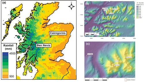
Figure 2. The North face of Ben Nevis showing the research site and other locations named in the text.
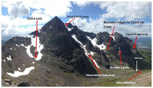
On Ben Nevis, moraines interpreted as having been deposited during the Younger Dryas occur above 300 m a.s.l., occupying the Alt a’Mhuillin valley that drains the northeast flanks of the mountain. At higher levels, well-developed corries exist with valley floors over 900 m asl; at Coire na Ciste, a linear accumulation of large boulders occurs at around 900m asl below Central Trident Buttress (). Late-lying snow patches are common at the present day with snow regularly lying in sheltered locations on Ben Nevis throughout the year (especially in Observatory Gully and Point Five Gully; Cameron et al. Citation2016). On the northeast face of Aonach Mor (1130 m) some 2 km to the northeast of Ben Nevis, late-lying snow patches are also common and associated with well-developed protalus or pronival ridges.
Using data from the Met Office 30-year (1981–2010) temperature record from a high-elevation automatic weather station (AWS) at Aonach Mòr (56.822 °N, –4.970 °W; 1130 m asl) and assuming a lapse rate of –6.0°C km–1 (Harding Citation1978) gives a mean annual air temperature of 1.8°C at 1345 m a.s.l.; equivalent to the summit of Ben Nevis. Measurements of air temperature and rainfall amount from historical weather station data collected between 1886 and 1903 at the summit of Ben Nevis (Operation Weather Rescue) indicate that mean annual air temperature at the end of the LIA was –0.24°C (dry bulb) and –0.62°C (wet bulb), that is, about 2.0°C colder than the present day.
Methods
Glacier-climate modelling
Glacier reconstructions were made using a 2-D energy-mass balance and ice-flow model that used the shallow-ice approximation (Plummer and Phillips Citation2003). This glacier-climate model is particularly suitable for investigation of small topographically constrained glaciers as the use of a distributed energy-balance model captures the topographic influences on local climatology and mass balance (e.g. Harrison et al. Citation2014). We used this glacier-climate model to test whether sites on Ben Nevis and Aonach Mor could have sustained small glaciers under climate conditions that may have been typical for recent cold periods such as the LIA. Model parameterization followed that used for the LIA in the Cairngorms while accounting for the observed differences in climate between eastern and western Scotland ( and ) (see Harrison et al. Citation2014). Ice flow was described as a combination of internal deformation and basal sliding, as these glaciers were likely to have been warm based. The topography of the model domain was described using the ASTER GDEM v2 digital terrain model resampled to a 25-m grid spacing. The model domain was defined by the hydrological catchment boundaries. Solar position was calculated for the present day and the LIA. Avalanching occurred when the topographic slope exceeded 30 degrees with a fraction of snow removed by each avalanche event. the minimum value for new snowfall to trigger an avalanche was 0.1 m. All glacier model parameters are given in .
Table 1. Glacier model parameters used in the study.
Table 2. Climate variables used to drive the glacier model.
Mean monthly temperature data were taken from the Met Office 30-year (1981–2010) records from the high-elevation AWS at Aonach Mòr (56.822 °N, –4.970 °W; 1130 m asl) close to the study site. Mean monthly rainfall data were not available from this AWS so were taken from the Met Office 30-year (1981–2010) records from a low-elevation AWS at Lochaber, which is also close to the study site (56.809 °N, –5.115 °W; 97 m asl). Rainfall values are not currently available from mountain stations, so the low-elevation value was used assuming a rainfall lapse rate of 0.0001 m m−1. This precipitation lapse rate is an order of magnitude lower than that quantified by Ballantyne (Citation1983) for lower elevations in Western Scotland and was chosen by comparing the total precipitation amount estimated using each lapse rate against observations. The total annual precipitation amount estimated across the model domain was about 4500 mm. Historical measurements from the summit giving total annual rainfall amount of about 4100 mm for 1886–1903. Monthly wind speeds were defined from the AWS measurements at Aonach Mòr with an annual mean of 10.6 m s–1. A summary of the climate data is given in .
The glacier model was used to explore the range of climatic conditions under which small glaciers equivalent to the observed limits could have formed in the study site. An accumulation of ice was defined as a glacier rather than a snow patch when the thickness exceeded 10 m and the model indicated that deformation occurred within the ice mass.
Uncrewed aerial vehicle survey
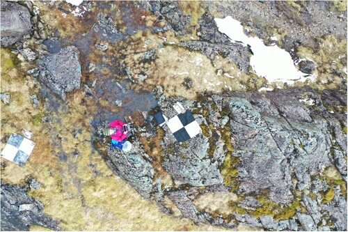
The linear boulder ridge on the northern side of Coire na Ciste was surveyed using a lightweight DJI Mavic-2 Pro drone equipped with a Hasselblad L1D-20c camera having an approximate 77 degree field of view and 20 mega pixels. Flight planning software ‘Pix4DCapture’ was used to plan and fly the drone along an automated flight path, using the ‘double grid’ option optimized for 3D landscape models. The camera angle was set to 80 degrees and overlap and sidelap set to 82%. The drone was flown at a constant altitude of 50 m above the take-off point, which resulted in areas downslope being imaged from a greater height. The steep cliffs and complex terrain around the feature, and the narrow nature of the gully in which some of the boulders were located prevented a more sophisticated flight planning procedure (e.g. terrain-following). A total of nine cross-hair-marked, black and white ground control points (GCPs), constructed from canvas and measuring 50 cm × 50 cm were deployed around the edges of, and within, the feature to provide a means of georeferencing the resultant model (). The locations of the nine GCPs were surveyed using a Trimble GEO7X system which offers spatial accuracy up to 1 cm. There were a few small snow patches located above and around the edge of the feature of interest, but no snow within the main gully itself. Photographs were screened visually for quality, and processed into photogrammetric products using Agisoft Metashape version 1.7.2 following a standardized workflow, building a dense cloud, mesh and then digital surface model (DSM) and orthomosaic products. The drone-captured locations found in each photograph’s EXIF header were used to initially align photographs after which, seven GCPs were used as training points and two as check points to further constrain the geometric alignment. Products were exported from Metashape and visualized in QGIS version 2.19.2. The drone was also used to capture still photographs of the feature from a greater height and a short video to provide some geographic context.
Figure 3. Example ground control point deployed at the Coire na Ciste site imaged here from around 10 m.
Lichenometry
Lichen size data were taken on the four largest boulders on the ridge; on the two largest boulders on the distal side of the avalanche fan from Number 5 Gully, and on an exposed bedrock surface 200m west of the CIC Hut near the valley floor. Measurements were restricted to the yellow-green Rhizocarpon geographicum spp and the diameter of the five largest lichen (Hughes Citation2010; Sass Citation2010; Leigh et al. Citation2020) on each boulder was made to the nearest millimetre using a ruler.
Results
Glacier model reconstructions
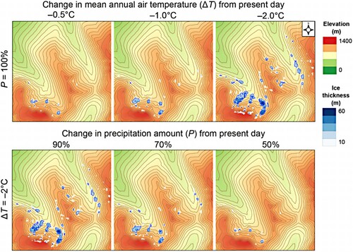
The initial simulation under present-day climate conditions produced no glacier ice in the study area and only small snow patches to the western side of Ben Nevis (). The glacier model predicts the development of small glaciers in sheltered north-facing locations on Ben Nevis, especially in Coire Leis and in Coire na Ciste and in sheltered north-facing locations on Aonach Mòr and on Carn More Dearg with only small reductions in mean annual air temperature and precipitation amounts compared to the present day (). The inclusion in the model of an avalanching function to move snow from steep slopes into the corries was important to enable sufficient snow accumulation to maintain glacier ice. Small glaciers were simulated under a range of palaeoclimates equivalent to a difference in mean annual air temperature (ΔT) from present-day values of between –1.0°C and –2.0 °C with either no change in precipitation amount or a reduction of up to 30%. The response times for these simulations were 100–150 years indicating that, from an unglaciated condition, a change to paleoclimate conditions similar to those expected during the LIA was sustained for at least a century and was sufficient to form small corrie and niche glaciers. Small changes in ΔT and annual precipitation amount would have caused the glaciated area to fluctuate but would have sustained small glaciers for as long as mean annual air temperature remained at least 1°C colder than the present day.
Figure 4. Simulation of small glaciers and simulated ice thicknesses under a range of cooler and drier climates on Ben Nevis and surrounding mountains.
Photogrammetry of the Coire na Ciste boulder ridge
A total of 75 photographs were captured in a single flight. The original photography had a spatial resolution of 1.25 cm per pixel and covered an area of 0.0155 km2. Control point error and check point error for the resulting photogrammetry products are provided in . The DSM had a resultant spatial resolution of 2.49 cm per pixel and point density of 0.161 points/cm². Every part of the main feature of interest was captured in more than nine photographs across its extent, which is usually a good indicator that it has been sampled exhaustively, providing optimal conditions for a high quality photogrammetric reconstruction (see processing report in supplementary information).
Table 3. Ground control and check point accuracy reported by Agisoft Metashape, all measurements in cm.
The boulder highlighted in a is Boulder 4 and shown at closer range in b also captured by drone, showing SH measuring lichen diameters. Large angular boulders were arranged linearly spanning a lateral distance of approximately 79 m from a height above sea level of 879–913 m. Using GIS, we established that the largest boulders in this collection had long axes facing the camera of between 3.03 and 5.80 m. shows the generated orthomosaic of the boulder ridge, while shows the topographic situation of the feature, derived photogrammetrically.
Figure 5. (a) a single image capture above the main gully feature in Coire na Ciste showing anomalously large and angular boulders arranged linearly. Close up image of Boulder 4 shown in (b).
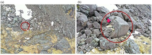
Figure 6. Orthomosaic of the feature in Coire Na Ciste, Ben Nevis. B1-B4 are the boulders sampled for lichen measurements on the ridge.
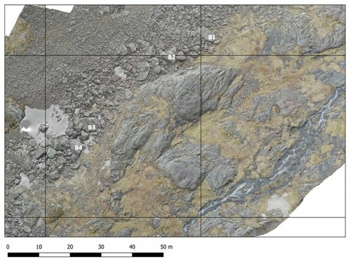
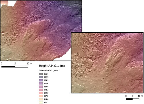
Figure 7. Digital Surface Model of the feature in Coire Na Ciste, Ben Nevis. Inset area shows the largest collection of boulders towards the top elevation of the feature.
Lichenometry
Very few lichens were found on the ridge boulders, and those were small (maximum lichen diameter was 58mm on Boulder 1; see a) compared with the lichen diameters found on the boulders located on the distal edge of Number 5 gully fan (maximum diameters of 82 and 61mm; b) and on the glaciated bedrock surface above the CIC Hut (maximum diameter of 75mm). See for details.
Figure 8. (a) Looking downslope from the boulder ridge in Coire na Ciste. Note the low lichen cover. The CIC hut is seen at the bottom of the valley; (b) Boulder 6 at the distal edge of the fan from Number 5 Gully showing lichen cover. Photo by K. Anderson.
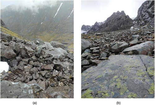
Table 4. Lichen size data (single largest lichen and mean of the 5 largest lichen (5LL) from Boulders 1–6 and the glaciated bedrock surface.
Discussion
Inferring palaeoclimate from glacial geomorphology
The results presented here suggest that relatively small reductions in mean annual air temperature were sufficient to generate and sustain glaciers in sheltered locations on Ben Nevis and adjacent mountains, even when associated with a reduction in precipitation amount. We previously suggested that these might have been typical of late Holocene conditions in line with results from previous simulations of glaciers in the Cairngorms (Harrison et al. Citation2014) and analysis of historical weather station measurements from the summit of Ben Nevis supports this conclusion. We argue that geomorphological evidence for small late Holocene glaciers is generally absent (and may partly reflect the destructive role of avalanches). However, in Coire na Ciste we have identified and mapped a distinct line of anomalously large boulders along part of the northern side of the corrie; their disposition likely precludes a rockfall or avalanche origin. Lichen measurements on the boulders suggest that the boulders were emplaced recently; much later than boulders on the distal edge of Number 5 gully which have substantial lichen cover (see a and b). We therefore suggest that this ridge represents a depositional unit created at the margin of a small glacier that existed in the corrie until relatively recently.
The cliffs and high corries of Ben Nevis may have been particularly sensitive to late Holocene cooling and glacier development. While plateau surfaces on the mountain are small compared with those in the Cairngorms the deep gullies, especially in the Observatory Gully area and Coire na Ciste, are the conduits for avalanches whose deposits build up to great thicknesses and they maintain extensive snow patches throughout the year. For instance, the annual snowpatch survey for 2021 (measured on 19th and 20th August) identified 17 distinct snow patches on Ben Nevis, with 44 identified in the Highlands of Scotland. This is similar to previous years, and snow patches have disappeared completely from Scotland on only six recorded years (1933, 1959, 1996, 2003, 2006 and 2017; Cameron and Fyffe Citation2020). We therefore suggest that the combination of wind redistribution of snow and topographic niches (with associated microclimates) in the Scottish Highlands is highly conducive to snow and ice persisting year round in suitable locations.
Potential periods of glacial conditions during the Holocene in Scotland
There are potentially numerous times when glaciers could have developed in Scotland (Manley Citation1949). For instance, during the renewed cooling during the 8.2ka event temperatures dropped 6 ± 2°C at Summit in Greenland (Alley and Ágústsdóttir Citation2005) and this period of cooling may have lasted for over 160 years (Thomas et al. Citation2007). Other reconstructions suggest a reduction in temperature of 1–3°C across large parts of the Northern Hemisphere (Matero et al. Citation2017) and, in northwest England, palaeoclimate reconstructions suggest a reduction in temperature of 1.6°C at this time (Lang et al. Citation2010). Given the likely sensitivity of Scottish glaciers to climate cooling, this might suggest that glacier limits currently described as having been deposited during the Younger Dryas were in fact also occupied several times during the Holocene.
The late Holocene and Little Ice Age
Palaeoclimate reconstructions of the late Holocene in Greenland and NW Europe suggest that conditions may have been cold enough on a number of occasions to develop glacier ice in sensitive mountain locations, although the timing and spatial extent of these is complicated (Kobashi et al. Citation2011).
There is little agreement on the drivers of such cooling events. For instance, van Geel et al. (Citation1996) argued that reduced temperatures in parts of NW Europe were associated with reduced solar irradiance about 2700 years ago, while Miller et al. (Citation2012) argue that LIA cooling was associated with volcanic activity enhanced by low summer Northern Hemisphere insolation triggering sea ice expansion (see also Lamb Citation1995). This period may also have been characterized by sustained easterly and north-easterly winds during winter and extreme snowfall (Dawson Citation2009; Moreno-Chamarro et al. Citation2017). Whether these changes were driven by shifts in the NAO is disputed. For instance, Moffa-Sánchez and Hall (Citation2017) argue that the NAO did not undergo long-lasting centennial shifts during the climatic events of the last 3000 years. They also discuss the significant cooling at 2300–2900 BP (the Iron Ages Cold Epoch) and at 1100–1200 BP (the Dark Ages Cold Period). Büntgen et al. (Citation2016) have also identified severe cooling from 536–660 AD and define this as the Late Antique Little Ice Age which may have exceeded LIA cooling, at least in central Europe. In addition, reconstructions of changes in bog surface wetness from the British Isles (a proxy for precipitation and evaporation) show considerable variability (Langdon et al. Citation2003) with shifts at around cal. 6650, 5850, 5300, 4500, 3850, 3400, 2800–2450, 1450–1350 and 250–150 BP. While several of these will have been accompanied by warmer temperatures, this may have also been periods when snow growth may have been sufficient to initiate glaciation in favoured locations in the Scottish Highlands. This view is supported by attempts to reconstruct glacier advances in western Norway during the early eighteenth century (Nesje and Dahl Citation2003) who argue that this was driven by increased winter precipitation accompanied by mild and humid weather associated with a positive NAO.
The precise timing of late Holocene glacier development is therefore not clear. Previous studies have suggested that the period most suitable for glacier development was probably during the late 17th and 18th centuries (Lamb Citation1995; Kington Citation2010) although cold and snowy winters and poor summers may not have occurred consistently throughout this time. Recent research using northern European tree-ring data has indeed identified multiple LIA-like cooling periods from 100–800 years in length from the mid-Holocene to the end of the LIA (Helama et al. Citation2021).
Conclusions
Glacier model simulations of Little Ice Age glaciers in the Cairngorms (Harrison et al. Citation2014) suggested that the change in climate from the present day during this period and the suitability of the landscape to support snow and ice accumulation was sufficient to form small glaciers within decades of the onset of cooling. Although meteorological observations are not currently made at the summit of Ben Nevis, a historical dataset provides hourly air temperature and rainfall measurements between 1886 and 1903. Comparing the calculated present-day temperature at the summit with historical observations indicates that mean annual air temperature at the summit was around 2°C colder between 1886 and 1903, which is consistent with the development of small glaciers.
We argue that these small glaciers could have fluctuated in and out of existence over several centuries throughout the cold periods of the Holocene and only made a minor impression on the landscape. Kirkbride et al. (Citation2014) caution that late Holocene glaciation in the Cairngorms was spatially very restricted and argued that ‘we suspect there would have been very few, if any, similar topoclimatic niches in the British mountains where contemporary late-Holocene glaciers could have formed’ (Kirkbride et al. Citation2014, p. 147). As in the Cairngorms, the development of small glaciers elsewhere during the late Holocene may have depended strongly on enhanced accumulation from avalanches or snow blow, or on the presence of deep, sheltered gullies. On Ben Nevis few large plateau surfaces are available for snow accumulation and avalanches mainly occur in the present day into Coire na Ciste from Number 5 gully and from the Castle Ridge and Observatory Gully areas. Ballantyne (Citation1989) discussed the evidence for a late-Holocene age avalanche impact fan in Coire na Ciste and reported that Gatty (Citation1906) argued that the fan was actively developing at that time. The age of this feature is undetermined but might be of significance in assessing the date of glacial melting in the Coire.
Testing our hypothesis that late Holocene glaciers existed in western Scotland will be difficult. Although we argue that the glaciers were probably warm-based the relatively small sizes of the glaciers reconstructed here suggests that they would have only been able to generate low subglacial driving stresses and were not dynamic enough to sustain rapid basal sliding and lee-side subglacial cavities (Sharp et al. Citation1989; Riihimaki Citation2005; Harrison et al. Citation2010). This inability to produce subglacially eroded rock and deposit these in moraines means that any dating program using terrestrial cosmogenic nuclide dating of moraine boulders will face the problem of inherited ages. In other words, these glaciers probably were only able to redistribute previously deposited rock debris and dating of this material cannot therefore be used as a test of the age of the glacier development. Glacier-climate modelling to investigate the possibility of sustaining small glaciers having developed in the mountains of Western Scotland during the late Holocene needs to be robust. To demonstrate that a model is suitable for application to this problem requires accurate simulations of a wider range of periods of glaciation, including the Younger Dryas. This is a task for the future, and should test the assumption that previous glaciations have been correctly assigned to dated cold periods.
In essence, our results suggest that small glaciers may have existed in several locations in the highest parts of the Scottish mountains during the late Holocene, and probably also during other cold periods in the Holocene. From this we argue that the current understanding of the glaciations of Scotland needs revision. Whether glaciers existed elsewhere in the British Isles is less certain; the glacier sites in the Cairngorms, on Ben Nevis and Aonach Mor have corrie floors higher than any in the mountains of Wales, English Lake District or Ireland, and therefore we believe that late Holocene glaciation was probably restricted to a few high elevation sites. However, glaciers may have been able to develop at many times during the Holocene as small warm-based glaciers would have been able to respond rapidly to the abrupt climate changes observed in the North Atlantic region during Lateglacial and Holocene periods.
Author contributions
SH and AR developed the initial hypothesis. AR and MP conducted the glacier-climate modelling. SH, KA and AD undertook fieldwork at the site. All authors co-wrote the manuscript.
Acknowledgements
We thank the two reviewers of an earlier version of this paper (Dr Martin Kirkbride and Dr Henry Patton) and the editor (Dr. Anne Solgaard) for their careful reviews and suggestions. We also thank Dr Simon Cook for discussions on this subject. Prof. Ed Hawkins, University of Reading, is thanked for providing unpublished historical weather data from Ben Nevis summit produced as part of the ‘Operation Weather Rescue’ project (https://weatherrescue.wordpress.com). These data were digitised by several thousand volunteer citizen scientists, and their efforts are also gratefully acknowledged. SH thanks the Quaternary Research Association for research funds used to undertake fieldwork on Ben Nevis.
Disclosure statement
No potential conflict of interest was reported by the author(s).
Additional information
Notes on contributors
Stephan Harrison
Stephan Harrison is a climate scientist working on the response of mountain glacial systems to climate change over Pleistocene and Holocene timescales. His research areas include the mountains of South America and the Himalaya.
Ann V. Rowan
Ann V. Rowan is a glacial geomorphologist with research interests in modelling past and present glacier behaviour. She works in New Zealand and in the Himalaya.
Adrian R. Dye
Adrian R. Dye is a glaciologist working on the influence of proglacial lakes on glacier evolution. His main research area is in northern Scandinavia.
Mitchell A. Plummer
Mitchell A. Plummer is a Quaternary geologist and physicist with research interests in Quaternary geochronology, especially in North America.
Karen Anderson
Karen Anderson is a remote sensing scientist whose work queries relationships between structure and function in eco-hydrological and geomorphic systems.
References
- Alley RB, Ágústsdóttir AM. 2005. The 8k event: cause and consequences of a major Holocene abrupt climate change. Quat Sci Rev. 24:1123–1149.
- Ballantyne CK. 1983. Precipitation gradients in wester ross, north-west Scotland. Weather. 38:379–387.
- Ballantyne CK. 1989. Avalanche impact landforms on Ben Nevis, Scotland. Scott Geogr Mag. 105(1):38–42.
- Büntgen U, Myglan VS, Ljungqvist FC, McCormick M, Di Cosmo N, Sigl M, Jungclaus J, Wagner S, Krusic PJ, Esper J, et al. 2016. Cooling and societal change during the Late Antique Little Ice Age from 536 to around 660 AD. Nature Geosc. 9:231–236.
- Cameron I, Watson A, Duncan D. 2016. Seventy four snow patches survive until winter 2015/2016. Weather. 71:228–230.
- Cameron I, Fyffe B. 2020. One Scottish snow patch survives until winter 2019/2020. Weather. 75:211–213.
- Clark CD, Evans DJA, Khatwa A, Bradwell T, Jordan CJ, Marsh SH, Mitchell WA, Bateman MD. 2004. Map and GIS databaseof landforms and features related to the last British Ice sheet. Boreas. 33(4):359–375.
- Clark CD, Ely JC, Greenwood SL, Hughes ALC, Meehan R, Barr ID, Bateman MD, Bradwell T, Doole J, Evans DJA, et al. 2018. BRITICE glacial Map, version 2: a map and GIS database of glacial landforms of the last British–Irish Ice sheet. Boreas. 47:11–e8.
- Dawson A. 2009. So foul and fair a Day. A history of Scotland’s Weather and climate. Edinburgh: Birlinn. 230 pp.
- Fabel D, Ballantyne CK, Xu S. 2012. Trimlines, blockfields, mountain-top erratics and the vertical dimensions of the last British–Irish Ice Sheet in NW Scotland. Quat Sci Rev. 55:91–102.
- Gatty VH. 1906. The glacial aspect of Ben Nevis. Geogr J. 27:487–492.
- Golledge N, Hubbard A, Sugden D. 2008. High-resolution numerical simulation of Younger Dryas glaciation in Scotland. Quat Sci Rev. 27(9-10):888–904.
- Golledge NR, Fabel D, Everest J D, Freeman S, Binnie S. 2007. First cosmogenic10Be age constraint on the timing of Younger Dryas glaciation and ice cap thickness, western Scottish highlands. J Quat Sci. 22(8):785–791.
- Harding RJ. 1978. The variation of the altitudinal gradient of temperature within the British Isles. Geograf Ann. series A. Physical Geography. 60(1-2):43–49.
- Harrison S, Glasser N, Anderson E, Ivy-Ochs S, Kubik PW. 2010. Late Pleistocene mountain glacier response to North Atlantic climate change in southwest Ireland. Quat Sci Rev. 29(27-28):3948–3955.
- Harrison S, Rowan A, Glasser NF, Knight J, Plummer M, Mills S. 2014. Little Ice Age glaciers in Britain: glacier-climate modelling in the Cairngorm mountains. The Holocene. 24:135–140.
- Helama S, Stoffel M, Hall RJ, Jones PD, Arppe L, Matskovsky VV, Timonen M, Nöjd P, Mielikäinen K, Oinonen M. 2021. Recurrent transitions to Little Ice Age-like climatic regimes over the holocene. Climate Dyn. 56(11):3817–3833.
- Hughes PD. 2010. Little Ice Age glaciers in the balkans: low altitude glaciation enabled by cooler temperatures and local topoclimatic controls. Earth Surf Proc Landf. 35(2):229–241.
- Kington J. 2010. Climate and weather. London: Harper Collins. 484 pp.
- Kirkbride MP, Everest JD, Benn DI, Gheorghiu D, Dawson AG. 2014. Late Holocene and Younger Dryas glaciers in the northern Cairngorm Mountains, Scotland. The Holocene. 24:141–148.
- Kobashi T, Kawamura K, Severinghaus JP, Barnola JM, Nakaegawa T, Vinther BM, Johnsen SJ and Box JE. 2011. High variability of Greenland surface temperature over the past 4000 years estimated from trapped air in an ice core. Geophys Res Lett. 38:L21501.
- Langdon PG, Barber KE, Hughes PDM. 2003. A 7500-year peat-based palaeoclimatic reconstruction and evidence for an 1100-year cyclicity in bog surface wetness from temple hill moss, pentland hills, southeast Scotland. Quat Sci Rev. 22(2-4):259–274.
- Lamb HH. 1995. Climate history and the modern world. London and New York: Routledge. 433 pp.
- Lang B, Bedford A, Brooks SJ, Jones RT, Richardson N, Birks HJB, Marshall JD. 2010. Early-Holocene temperature variability inferred from chironomid assemblages at hawes water, northwest england. The Holocene. 20(6):943–954.
- Leigh JR, Stokes CR, Evans DJA, Carr RJ, Andreassen LM. 2020. Timing of Little Ice Age maxima and subsequent glacier retreat in northern Troms and western Finnmark, northern Norway. Arct Alp Res. 52(1):281–311.
- Manley G. 1949. The snowline in Britain. Geograf Ann. 31:179–193.
- Matero ISO, Gregoire LJ, Ivanovic RF, Tindall JC, Haywood AM. 2017. The 8.2 ka cooling event caused by laurentide ice saddle collapse. Earth Planet Sci Lett. 473:205–214.
- Miller GH, Geirsdóttir Á, Zhong Y, Larsen DJ, Otto-Bliesner BL, Holland MM, Bailey DA, Refsnider KA, Lehman SJ, Southon JR, et al. 2012. Abrupt onset of the Little Ice Age triggered by volcanism and sustained by sea-ice/ocean feedbacks. Geophys Res Lett. 39(2):L02708.
- Moffa-Sánchez P, Hall IR. 2017. North Atlantic variability and its links to European climate over the last 3000 years. Nature Comms. 8(1):1–9.
- Moreno-Chamarro E, Zanchettin D, Lohmann K, Luterbacher J, Jungclaus JH. 2017. Winter amplification of the European Little Ice Age cooling by the subpolar gyre. Scientific Rep. 7(1):1–8.
- Nesje A, Dahl SO. 2003. The ‘little ice age’–only temperature? The Holocene. 13(1):139–145.
- Plummer M, Phillips F. 2003. A 2-D numerical model of snow/ice energy balance and ice flow for paleoclimatic interpretation of glacial geomorphic features. Quat Sci Rev. 22(14):1389–1406.
- Riihimaki CA. 2005. Sediment evacuation and glacial erosion rates at a small alpine glacier. J Geophys Res. 110(F3):F03003.
- Sass O. 2010. Spatial and temporal patterns of talus activity–a lichenometric approach in the Stubaier Alps, Austria. Geograf Ann. 92(3):375–391.
- Sharp M, Campbell Gemmell J, Tison J-L. 1989. Structure and stability of the former subglacial drainage system of the Glacier de Tsanfleuron, Switzerland. Earth Surf Proc Landf. 14:119–134.
- Thomas ER, Wolff EW, Mulvaney R, Steffensen JP, Johnsen SJ, Arrowsmith C, White JWC, Vaughn B, Popp T. 2007. The 8.2 ka event from Greenland ice cores. Quat Sci Rev. 26:70–81.
- van Geel B, Buurman J, Waterbolk HT. 1996. Archaeological and palaeoecological indications of an abrupt climate change in The Netherlands, and evidence for climatological teleconnections around 2650 BP. J Quat Sci. 11:451–460.