
ABSTRACT
The article explores the Pervasive Information Architecture (PIA) framework as a theory and set of tools that support the identification of both the multiple physical/digital, spatially oriented elements that make up urban life and, importantly, the obstacles and barriers to information flow between them. As an example, the article presents the application of the framework in studying how first-generation immigrants experience the urban natural environment in Turku, Finland. This research contributes to advancing our understanding of how Pervasive Information Architecture can be effectively used to analyse, design, and optimize urban landscapes, thereby promoting a more inclusive urban development.
Introduction
In the contemporary, data-driven society, physical and digital spaces have become inextricably entangled, to such an extent that it is difficult (and counterproductive) to try to separate them (Amin and Thrift Citation2017; Benyon Citation2014; Valentini, Lorusso, and Stephan Citation2020). This is especially true when considering the urban realm. Indeed, in urban space, digital technologies are an integral part of the places individuals live their lives in, work, shop, travel, and meet. These places are neither physical nor digital: they are indeed blended spaces (Benyon Citation2014) and constitute the contemporary urban structure on which the digital or smart city is built (Kitchin, Cardullo, and Di Feliciantonio Citation2019). A blended space is a space ‘where a physical space is deliberately integrated in a close-knit way with a digital space’ (O’Keefe and Benyon Citation2015, 7) and whose structure and properties emerge from its specific, embodied combination of physical and digital.
‘Digital environment’ is a shorter way to refer to those technologies that ‘profoundly shape the way we experience the world around us [but] are hidden from our direct perception. Examples … include social/machine learning algorithms, information and communication technologies and technologies that fall within the Internet of Things’ (Wood Citation2021, 632). Scholarly works in various disciplines have broadly acknowledged their entanglement with space (DeNardis Citation2020; Tedeschi Citation2022). Kitchin, already in 1998, recognized how ‘cyberspace, rather than providing an alternative world, exists in a symbiotic relationship with real space’ (Citation1998, 403); ‘phrases such as “being on the Internet” or “being off the Internet” no longer have distinct meanings’ (DeNardis Citation2020, 15).
In the Onlife manifesto, Floridi acknowledged the fact that humans need to be re-interpreted ‘as informational organisms living and interacting with other informational agents in the infosphere’ (Floridi Citation2015, 54), which incorporates the physical and digital spaces as one. For Kitchin and Dodge (Citation2014), code has profoundly carved its way into the urban, so much so that it keeps materially producing new paths and directions. For example, these paths have become so pervasive in the urban space that even the simple act of walking on a street entails that individuals are always crossing some kind of digital, coded space as well – the mobile phone’s GPS tracking their movements, WI-FI and mobile data networks filling the air, location-enabled online services that they encounter just by moving around (Greenfield Citation2017). Indeed, software is also spatial (Dodge, Kitchin, and Zook Citation2009), and digital has made its way into physical space to such an extent that they have effectively blended into a novel space (Benyon Citation2014), one that affects the urbanites’ everyday life (Resmini and Lacerda Citation2016; Tedeschi Citation2022) and that presents new characteristics, new affordances, and new possibilities for action.
More systemic approaches (Armson Citation2011) that can help model, describe and explain the urbanites’ environment as a blend of physical and digital space, and the important role that information plays in it, are then needed to carry out urban geography research. One such method (and theory) is time-geography, which has been updated with new tools and perspectives from the increasingly blended nature of geographical spaces (Couclelis Citation2009; Kwan Citation2002). Time-geography methods can for example shed light on the variation in the use of technologies in their socio-spatial contexts, looking at how they are integrated in urbanites’ everyday lives and micro-activities (Thulin and Vilhelmson Citation2012). These micro-activities are relevant because, as De Certeau maintained, ‘they secretly structure the determining conditions of social life’ (Citation1984, 96). Here time-geography can be used ‘to depict and further analyse how communicative actions interact, complement, and compete in the daily lives of individuals’ (Thulin and Vilhelmson Citation2012, 392), in both physical and digital spaces.
Similarly, information architecture, especially contemporary information architecture (Davis Citation2012; Resmini Citation2021) as it has been developed in the Pervasive Information Architecture (PIA) framework (Resmini and Lindenfalk Citation2021; Resmini and Rosati Citation2011), is concerned with structuring information flows for everyday activities that straddle physical and digital spaces. However, unlike time-geography, PIA is a generative, designerly framework that looks at how the layout, structure and informational content of the environment can help to build a more coherent, consistent, and meaningful experience of the urban.
The article highlights the role of PIA as a theory and set of tools that can be successfully applied to urban geography research by looking at a multiplicity of physical/digital elements (touchpoints) that are connected by the information flowing between them (through seams). These information flows create the seamful environment in which the different experiences of the urbanites unfold as they pursue their goals and desired future states (Benyon and Resmini Citation2017; Resmini and Lindenfalk Citation2021). The article presents an application of the framework to a study of how immigrants experience the urban natural environment in Turku, Finland. The goal of the research was to improve the immigrants’ health and well-being by studying, and if necessary, better supporting their relationship with urban natural areas in and around the city.
The research questions are as follows: (1) how can the PIA framework be applied to urban geography research? (2) how can it contribute to supporting a consistent and meaningful everyday life in blended environments?
Accordingly, the article is divided as follows: (1) the next section presents the PIA theoretical framework and its connections with the broader field of urban geography research, and within it, the layout, structure and informational content of the urban environment; (2) then, the materials and methods of the research are listed, highlighting their connections with PIA; (3) finally, the adoption of the framework in the specific project studying urban nature as experienced by first-generation immigrants living in Turku, Finland, is discussed. Conclusions recommending PIA as a framework to be used in urban geography research are then drawn.
Pervasive information architecture in urban geography research
The PIA framework is a generative, heuristic framework for the design of the blended, digital/physical space where a certain experience unfolds (Resmini and Rosati Citation2011). An ‘experience’ is here intended, expanding on Grossman (Citation2006) and following (Resmini and Lacerda Citation2016), as ‘any event an actor considers relevant and related to achieving a desired future state’, a definition that ‘fits naturally to complex, pervasive experiences such as “paying one taxes”’ or, as is our case, enjoying the natural environment of the city. These experiences ‘present fuzzy boundaries’ and are those ‘mostly influenced by personal mobile computing (and) social interactions’ (Resmini and Lacerda Citation2016).
The framework has been variously applied in the fields of user experience, information architecture, computer science, urban geography, and urban design, among others, even though its application to the urban field is still limited. A pervasive information architecture models and describes a semantic space of action that encompasses all experience-related spaces, contiguous and non-contiguous, and that is entirely actor-driven and actor-centred. This semantic space, which bounds what is defined as the experience ecosystem (Resmini and Lindenfalk Citation2021), the ‘place in which the experience unfolds’ (Benyon and Resmini Citation2017), is primarily approached as a system of relationships between the information-based elements that are part of the experience. The PIA framework does not represent a network (Castells Citation2009; Citation2010a; Citation2010b; Massey and Wield Citation2003) or actor-network (Latour Citation2005) theory approach to the problem space, but rather a designerly hands-on approach to sense-making and co-design with research participants. As illustrated later in the paper, it is conceptually structured to favour immediacy, participation and discussion over ‘mathematical’ precision.
The PIA framework introduces five heuristics that are used to explore and design an information space, formulated on the basis of research and project work conducted between 2005 and 2010 (Resmini and Rosati Citation2010): placemaking, consistency, resilience, correlation, and reduction (Resmini and Rosati Citation2011). The five heuristics are medium-nonspecific, and can thus be used to structure the relationships between all informational elements in the environment (actors, tasks, touchpoints, seams) and design the information flows that allow people to make sense of their experience (Benyon and Resmini Citation2017). In this sense, the framework introduces an information-based view of habitable space that resonates with the idea of humans as informational beings and ‘information-processing machines whose existence depends on the ability to interpret the information present in their surroundings’ (Salingaros Citation1999, 32), including the urban spaces they inhabit (Tedeschi Citation2019). The primary goal of the framework is therefore the creation of a coherent and meaningful sense of presence and belonging through the correct shaping of information flows in support of placemaking, sense-making, and agency. The heuristics have been variously applied in research (Covert Citation2012; Renzi Citation2017; Renzi and Almeida Citation2020) and in projects dealing with urban mobility (Resmini et al. Citation2021), ambient-assisted living (Lindenfalk and Resmini Citation2019), the design of extended reality environments (Resmini, Lindenfalk, and Jauhiainen Citation2023) and of cultural heritage sites (Rosati Citation2020; Rosati, Schena, and Massacesi Citation2014).
The following paragraphs shortly define the five heuristics and the way they relate to urban geography research. While the heuristics are here explained separately, they are strongly interrelated and are meant to support each other.
Placemaking
The heuristic placemaking benefits people by contributing to building a sense of place, increasing way-finding across physical, digital and blended environments, and reducing disorientation (Resmini and Rosati Citation2011). Based on the acknowledgment that ‘the most fundamental human experience’ is that of ‘apprehending oneself as a body located in space’ (Ryan, Foote, and Azaryhau Citation2016, 35), and that ‘spatial thinking is the foundation of abstract thought’ (Tversky Citation2019, 72), placemaking is the fundamental heuristic upon which the other four are grounded. A sense of place and belonging is supported by unencumbered agency leading to experiences that produce positive feelings and outcomes. For this purpose, physical, cognitive, cultural, and emotional barriers and obstacles would need to be removed or reduced as much as possible.
This idea of placemaking is well-known and has a long history in urban geography research and design as well. While it is not possible to review here the entirety of the literature on placemaking in the discipline, suffice it to cite for example the Street Life Project, started by William Holly Whyte in 1969 in New York (Whyte Citation1988). Through the observation of urban public spaces and the active interaction with people using them, Whyte aimed to build meaningful spaces facilitating the community activities and movements. Together with him, other scholars, for example Lynch (Citation1960) and Appleyard, started exploring the socio-psychological sides of the use of the public space, and how they could become relevant dimensions in the design of the space itself, and in the way in which the latter could facilitate a sense of place, belonging, and meaningfulness (see for instance Ewing et al. Citation2016; Southworth et al. Citation2012). In contemporary cities, studies of the layout, structure and informational content of the urban environment for placemaking need to consider and incorporate digital space and the way it blends with physical space to create a novel space of action, in so doing acknowledging and moving forward with the digital turn in geography (Ash, Kitchin, and Leszczynski Citation2018).
Consistency
In this sense, it is important that the same structural logic is applied throughout the different digital and physical environments that constitute the space of the experience (Resmini and Rosati Citation2011) to avoid disorientation and cognitive overload. This is external consistency. Internal consistency is typical of medium-specific artefacts, where information is usually designed to suit a well-defined purpose in well-defined contexts. Internal and external consistencies are integrated, and the need for such integration is apparent when we look at experiences, such as those happening in urban space, where people have to rely on a number of different physical and digital touchpoints, for example when coupling information on a ticket to information on public transit coming from ambient displays, or when using digital or augmented reality map systems such as Google Maps to supplement any cues provided by the physical environment like landmark buildings and soundscapes. To avoid cognitive friction, the organizational principles structuring the pieces of information that need to be accessed should be the same or relatable.
This idea of structure and consistency relates to the concept of rhythm. In their everyday lives, urbanites routinely follow certain patterns of movement. This means that their activities have an inner rhythm, and such rhythmic repetition is, or should be, supported and facilitated by the built environment. The literature on rhythm analysis is vast; one of the most famous works on it was by Lefebvre (Citation2004 [1992]), where he showed how space and time are rhythmically interrelated in the production of everyday life. This rhythmicity of urban life – which again trickles down from the fact that spaces are experienced by urbanites as eminently embodied – can be translated into a design element guiding the internal and external consistency of the layout, structure and informational content of the urban environment, whereby ‘the weaving together of numerous rhythms produces distinct forms of spatio-temporal consistency’ (Spinney Citation2010, 117) in cities. Haverty and Bates (Citation2021) have explored how the ideas of rhythm and time relate to the structures of contemporary pervasive information architecture.
Resilience
Rhythm thus relates to the fact that the design of a given space needs to be attuned to its users. This has to do with the way in which people and their space find a common rhythm, how embodiment shapes the relationship between people and a certain space and how the space itself plays a primary role in reinforcing belonging and ontological security. In this sense, resilience means that the information architecture should adapt to the specific needs and seeking strategies of people (Resmini and Rosati Citation2011). The literature on cities and resilience is vast; lately the attention is concentrated on how cities are flexible enough to deal with unexpected adversities, also thanks to the pervasivity of information and communication technologies (Sharifi et al. Citation2022). However, resilience is not simply adapting to unpredictable circumstances: it is also the capability of an urban space to affect and be affected by the micro-movements and activities of the urbanites (Tedeschi and Gadd Citation2021); in short, to attune itself to their bodily presence and provide different possibilities of experiencing and embodying it: ‘Urban space should have certain qualities if it is to be responsive to human feelings and sensibilities’ (Salingaros Citation1999, 30).
Reduction
All five heuristics aim at reducing disorientation in space and its negative consequences, which are partly due to the increasingly growing amount of information people are constantly exposed to in blended spaces. Reduction specifically refers to minimizing the frustration and cognitive load that is related to choosing from a growing set of information sources and services (Resmini and Rosati Citation2011). Thus, the information architecture necessarily has to correctly manage the information loads of an environment, so that choices are not removed, but rather reorganized in ways that make them more accessible and meaningful for people.
The idea of information overload is cited in a variety of disciplines, including planning for (smart) cities (Bawden and Robinson Citation2020). Indeed, not only are humans informational beings, but the urban space can be itself defined as an information space (Tedeschi Citation2019) where:
We build structures so that we may connect to them; this extends our consciousness to our immediate surroundings. If, on the other hand, we cannot connect to surrounding surfaces, then we find ourselves in an alien environment, and our most basic instincts drive us to leave it. (Salingaros Citation1999, 29)
Correlation
When we move across spaces (for example, from physical to digital space or vice versa) or between contexts, relevant information provided by less known or hard to use touchpoints may remain disconnected and thus unattainable. This again might be a source of confusion and disorientation as information that would make a certain activity simpler or possible at all is missing from the person’s context and no links are established with information from other useful sources. Here, the heuristic correlation means that the information architecture proposes relevant connections between pieces of information, goods and services to help people achieve their goals or latent needs (Resmini and Rosati Citation2011). One of the purposes of an information space should be to help the user build such proper/new correlations and, thus, shared meaning, so that all relevant pieces of information can be meaningfully brought together.
Similarly, the design of the urban, where the physical and the digital spaces are inextricably blended in the urbanites’ experience of everyday activities, should support continuity and correlation across information flows (Arthur and Passini Citation1992; Jonsson Citation2002). This should help overcome, or at least reduce, the physical, cognitive, cultural, and emotional barriers that the lack of meaningful connections in the urban space sometimes brings about.
Materials and methods
This section introduces a demonstrator case, used as an example of how a pervasive information architecture approach can be applied to urban geographical research. Thus, here the focus is not the empirical study itself, and its results, but rather how the framework works in detail. The fieldwork was conducted in Turku – a city located on the southwest coast of Finland. Of the city’s 194,000 inhabitants, 12.6% have a foreign background (Statistics Finland Citation2020a). Russian, Arabic, and Somali are the most frequently spoken foreign languages in Turku (Statistics Finland Citation2020b). The demonstrator case in Turku concerns these immigrant groups (Arabic-, Somali-, and Russian-speaking) and their access and enjoyment of the outdoors.
The City of Turku has expressed the need to understand how these people use the city space, and thus, to conduct sustainable and inclusive action to improve the immigrants’ health and well-being, reduce the third-level digital divide (impact of the internet, social media and, more broadly, digitalization on the lives of the population; Schreeder, Van Deursen, and Dijk Citation2017) negatively affecting access to the urban environment, and enhance the attractiveness of urban nature in more remote and segregated places. Some members of these groups have limited knowledge of their own surroundings and of the activities in nearby natural areas (Tedeschi et al. Citation2022). Looking into the research participants’ everyday activities, identifying the barriers to access information about natural areas, supporting smooth information flows between the physical and the digital spaces of outdoors experiences, and redesigning the urban space accordingly to increase the sense of belonging and ‘being-in-place’ (placemaking) would help make less known natural areas more present and attractive for immigrants living in different parts of the city.
Interviews were used to increase our understanding of how first generation immigrants experience urban nature and to collect information about the physical and digital steps the research participants take when they do. In other words, we asked them to describe their experiences in natural urban spaces and produce a narrative list of all the micro-activities they go through when they decide to carry out outdoor activities (such as taking the bus, walking, opening Google maps, using an app with nature paths, etc.). We conducted 13 semi-structured interviews, 11 in-depth individual interviews and two group interviews. These were used to gain the urbanites’ general perspective, find out how the information was flowing (or not) between the physical and digital spaces they encountered, and reach a better understanding of how the design of the urban (natural) spaces could be changed or improved to support placemaking.
Probes – an ethnographic method – were used to gain even deeper insight into individuals’ daily tasks in relation with nature: specifically we looked at how the blended nature and design of space supported them, the resources everyone had to reach their goals, and the barriers to access information. The probes consist of ‘individual packages of mixed-media materials that are given to research participants to allow them to document and record elements of their daily lives and thoughts’ (Robertson Citation2008, 2). 13 participants volunteered to record their daily lives and keep diaries for 14 days (between May and June 2021). The probes included in-depth interviews after the individual material collection. The participants had two daily tasks: to state what captured their attention in their environments and/or made them (un)comfortable, and to explain when they used a paper map, a website, an app, or asked for directions, to orient themselves in the city, or to find more info about nature walks and paths. Specifically, they were asked to share what app or website they were using, how they were using it, and how they felt about it. In the instructions, we also listed two apps and two websites to move around Turku and its surroundings, and to find services in the city. The participants wrote notes, took photographs, recorded voice messages, and made drawings according to their preferences. Informed consent was asked before the activities.
The written data (e.g. transcribed interviews, notes, diaries) and pictures and photographs were analysed using thematic content analysis (Nowell et al. Citation2017) with the help of the NVivo® program. Here, the pervasive information architecture framework guided our analysis of the data, as described in the next section. First, we built the journeys towards nature using the research participants’ interviews and the material they shared with the probes. To do this, we identified the different steps that are needed to reach nature. Finally, the journeys were represented using the Personal-Local-Remote (PLR) syntax method (Resmini and Lindenfalk Citation2021) and combined into an ecosystem map.
Applying the pervasive information architecture framework to data
The pervasive information architecture framework and its heuristics – placemaking, consistency, resilience, reduction, correlation – offer a way to formalize how the experience ecosystem as a whole does or does not support people as they try to achieve their desired future states. It concerns itself with the information flows that structure the space of the experience and how they may or may not be accessible to people when they are needed, in a way that makes sense to people and that helps them accomplish their goals. For this purpose, it is necessary to start from observing what people do in their everyday urban life, and analyse how information flows facilitate the variety of micro-activities the urbanites carry out, and how their absence or current configuration hampers or prevents them. Accordingly, we used the interviews and the probes to identify the self-described relevant micro-activities the research participants took when they wanted to be outdoors, and analysed them to formalize ‘steps’, the informationally relevant elements that identify touchpoints and seams that either helped or hindered them along the way. We called ‘journey’ the collection of all the steps needed to describe an entire experience, usually describing a trip from home to engage in some activity in a natural urban area, and ‘path’ its formal representation in PLR syntax.
From all of the research participants’ stories we identified at least one journey to nature per person, with a few more active persons providing us with several journeys, and produced 32 individual journeys in total. Each journey was also described through a storyboard, explaining the initial goal and the actions and steps required to achieve it. For example, one research participant explained that, after a long study day, they wanted to go outside to refresh themselves. First, they used the internet to look for a natural place and then called a friend to ask if they wanted to join. After that, they searched for and then chose a means of transportation that could take them to their destination. Several further actions were taken before the natural area was reached. In some cases physical, cognitive, cultural, and emotional barriers emerged that delayed, changed, or completely halted the initial intention: a lack of company or a lack of information on how to reach the desired destination made it less enticing or problematic; the weather conditions in the winter and the icy or slippery ground made leaving the house seem impractical or possibly dangerous.
Personal-Local-Remote (PLR) syntax
The PLR syntax is a method to map experiences as a system of simple spatial relationships that form an actor-centred information architecture (Resmini et al. Citation2021; Resmini and Lindenfalk Citation2021).
It was specifically created to tie together the processes of discovery and improvement so that a solid, if designerly, foundation could be provided to the heuristic-based approach of the PIA framework. Since the design process for an experience in blended space concerns itself primarily with the global structure and dynamics of the ecosystem itself, the PLR method aims at making the information architecture intuitively visible so that ‘undesirable patterns of behaviour’ (Gharajedaghi Citation2011, 150) that maintain and recreate the current homeostasis can be culled, modified, recast through the introduction of alternative that challenge the current underlying behavioural assumptions (Gharajedaghi Citation2011).
The syntax was developed with two specific goals in mind: to allow collaborative mapping using a simple but formalized low-fidelity hands-on approach, so that the method could be used in the course of co-design activities; and to account for both a person’s individual experience of their journey and the vastly more important general overview of the experience ecosystem as a non-linear space of relationships between elements (touchpoints) connected by means of information flows. To do so, PLR relies first on the formalization of ‘paths’, and second on the formalization of one or more ‘ecosystem maps’.
From journeys to paths
PLR first represents a person's own account of their experience as a formal path whose geometry intuitively reflects that experience’s cognitive load and complexity by means of a few basic spatial conventions (Lindenfalk and Resmini Citation2019; Resmini and Lindenfalk Citation2021). Shorter, straightforward or right leaning paths represent journeys that required the least effort; paths that lean right represent journeys that relied on access to local informational touchpoints, and required some more effort; paths that veer or lean left, that consist of a long series of steps, or that include repetitive loops describe experiences which required the most effort, and often involve temporal delays or movement between locations ( and ).
Figure 1. PLR syntax – Example of path.
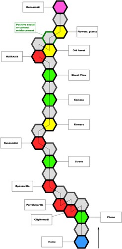
Figure 2. PLR syntax – Example of path.
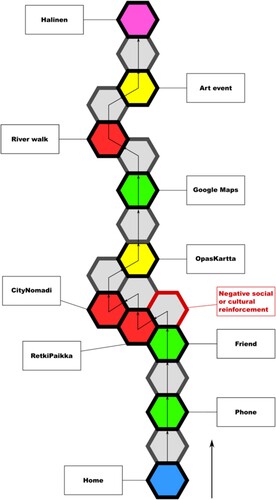
Paths consist of a sequence of ‘steps’. In a path described according to the PLR syntax, hexagons are used to represent the individual steps taken by a person, such as ‘taking a bus’. Steps comprise a touchpoint (a coloured hexagon) and the seam (grey hexagon) that connects it to the next touchpoint. Since PIA takes an information-based approach, a touchpoint could be any informational element part of the journey: it could be a physical object such as a bench or a bike; a location, such as a school, forest, or playground; a digital artefact, such as a website, mobile app, or ambient display; a biological entity, such as person (friend, teacher or neighbour), animal, or plant; or an event such as a picnic, outdoor exercise, or weather situation. The granularity of touchpoints (a smartphone vs a function of a certain mobile app on a smartphone) is derived from the participants’ journeys: it can vary and it is a significant path characteristic, as it provides an initial insight into how the person values, either positively or negatively, or does not value and ignores a specific interaction. Paths are linear narratives that develop through time. Arrows are used to indicate directionality and progression.
A formalized PLR syntax is then used to colour- and positionally-code each touchpoint to intuitively indicate the effort, movement, or time required to access it. Personal touchpoints (coded green, placed straight on) represent information the person possesses, for example knowledge of a bus timetable, or a smartphone to look arrival times up. Little to no effort is usually needed to access and use personal touchpoints. Local touchpoints (coded yellow, placed right) represent information in the person’s immediate environment, such as a real-time display or a bystander. Local touchpoints require more effort than personal touchpoints. Remote touchpoints (coded red, placed left) represent information that is either unknown, harder to obtain, or distant in time or space, and require the most effort, energy, or movement. Local and remote touchpoints are further divided into stronger (placed side forward, easier to access) and weaker (placed side backward, harder to access) ones according to the degree of effort needed. Grey seams between touchpoints represent the flowing of information that allows the person to move forward in their experience (Resmini et al. Citation2021). and show examples of two different paths built according to the PLR syntax and based on the journeys described by the research participants: the individual steps were extracted from the research participants’ written narratives, discussed, and then formalized in accordance with the syntax.
The personal narrative of the person’s experience starts at the blue hexagon. In the person is at home and decides to take a walk. They use their smartphone (first touchpoint) to look things up. The smartphone is a personal item that the person possesses, and it is right there for them to use, so it is green, personal. They want to be sure of the route and see if there are sights or places to visit. Therefore, they open the CityNomadi app (second touchpoint), but they cannot get the app to work (red, remote weaker). Next, they try to use Palvelukartta, which is a map of services provided by the city (third touchpoint). Unfortunately, this app does not provide them the information they need either (red, remote weaker). Lastly, they try Opaskartta, which is a guide map provided by the city. This map is better and allows the person to figure out where to go for their walk (red, remote stronger). They set out on foot (green, personal). The walk to their destination (Runosmäki) is quite long, requires checks to be sure one is on the way, and some time (red, remote stronger). While walking, they see flowers by the road and stop to look at them (yellow, local stronger). They use their phone to take a picture of the flowers (green, personal). Next, they open Google maps to check their direction again using the street view mode (green, personal). They continue to walk towards Mälikkälä, which again takes some effort (red, remote stronger). When they reach Mälikkälä, they find a beautiful forest and decide to enter it (yellow, local weaker). This type of forest reminds them of their childhood home. This feeling is marked in a seam with a green border, indicating positive social or cultural reinforcement. They observe more interesting flowers and plants (yellow, local stronger) and then reach their destination (purple touchpoint).
In , the path begins at home once more (blue hexagon). The person would like to go out, but they would prefer to have a friend accompany them. They then take their phone (green, personal) to call a friend. However, the friend declines the invitation. This generates a negative feeling, marked with a red border on the seam, indicating negative reinforcement. Despite this, they open the Retkipaikka app, which is new to them, to find a nice outdoor area to visit. The app shows different places for outings, but uses symbols that the person does not understand, making it ultimately useless (red, remote stronger). They try the CityNomadi app, but it is also difficult to understand (red, remote stronger). Finally, they open the Opaskartta, a guide map provided by the city, which is more familiar to them (yellow, local stronger). They find an outing place they like and open Google Maps to check for a suitable route (green, personal). They then go out and walk along the river towards their destination, a relatively long walk (red, remote stronger). On the way, they stop at an art event by the riverside (yellow, local stronger). After a while, they arrive at their destination (purple touchpoint).
Sometimes barriers that impede the flow of information emerge and people withdraw from action. These barriers were represented via a red border on the seam and named accordingly. In , the seam in the third step that begins with the remote touchpoint is one such barrier: a ‘negative social or cultural reinforcement’, as per its label, that generated initial frustration and stunted progress. Language barriers, user experience issues with an app or website, or environmental constraints can also all act as negative reinforcements. In the third step of , the person gives up on the apps Retkipaikka and CityNomadi and overcomes the difficulty by using another app (OpasKartta) to try to find more info about the destination place (Halinen), until finally settling on Google Maps. While CityNomadi (red, remote weaker) was not useful in terms of achieving the goal of knowing more about the destination, the local map Opaskartta (yellow, local stronger) was a bit more familiar to the user, but the person still needed Google Maps to find the route to the destination.
In general, barriers encountered in the study had emotional, cultural, cognitive, or physical reasons. For example, an informational text was provided in a language that the person was unable to understand; or the person felt uncomfortable in a given situation because they did not know what behaviour was expected of them (paths were not clearly marked or differentiated, or the rules for accessing a natural area were unclear). Atmospheric weather also acted as a physical barrier to outdoor activities during parts of the year (for example by making roads icy and slippery).
Judging whether a touchpoint should be considered local or remote required careful analysis of the data available. This point is acknowledged in PLR, which stresses the qualitative and contextual nature of the formalization process (Resmini and Lindenfalk Citation2021). For example, visiting a playground was a typical activity mentioned in the study that required such attention: for adults with children, it is usually a familiar everyday activity in a place close to home. That is, it should be a local touchpoint. But it is not infrequent to encounter journeys in which a playground is either further away or the adults are not so knowledgeable of its whereabouts, of access rules, or have themselves social or cultural constraints that might suggest the type of cognitive load best represented by a remote touchpoint.
From paths to the ecosystem map
After analysing the research participants’ journeys and formalizing them into paths, the second step of a PLR process requires combining them in what is called an ecosystem map.
The paths represent the personal experience of individuals: they are linear, directed, and partial. The ecosystem map synthesizes all partial views in a non-linear, directionless view that only presents the integration, flow, and relative importance of all touchpoints encountered by the individual interviewees that had that specific experience (Lindenfalk and Resmini Citation2019; Resmini et al. Citation2021).
Touchpoints from the individual paths are clustered and counted, and seams between the clusters are identified, regardless of whether they were traversed only once (i.e. that seam only existed in one path) or many times. Since the seams represent the information flow between two touchpoints, the absence of a seam indicates that no movement between the two was described in the journeys and therefore formalized in the paths: from the perspective of the people having the experience, this means that no one could or would progress by connecting those touchpoints (Resmini et al. Citation2021).
In this sense, the ecosystem map conveys primarily information about whether information flows exist between touchpoints so that disconnected touchpoints can be immediately identified and eventually acted upon if necessary, but it also provides important secondary insights that relate to integration and relative importance. Integration is represented by the number of seams a touchpoint cluster has to other touchpoint clusters, and it directly correlates to how the specific touchpoint represented by the cluster allows people to move forward and does not represent either a bottleneck or a dead end, experience-wise. Relative importance is represented by the number of hexagonal tiles that comprise a specific cluster, and it visually indicates how consistently relevant that specific touchpoint was in the various individual journeys.
Clustering touchpoints requires them to be categorized, and the level of granularity used for the categorization is a contextual decision that has to be taken on a case by case basis based on the overall goals the mapping is meant to support. In this case, for example, the touchpoints ‘car’, ‘bus’ and ‘bike’ were combined and labelled as ‘transport’ since there was no interest in differentiating among them. Similarly, different outdoor areas named in the journeys were combined under the label ‘nature area’. Only a few touchpoints that were consistently identified by participants by name become categories and then clusters in their own right. The Google Maps app, used by most of the research participants to navigate to their destinations and always clearly identified as such, was one of these. Once the process was complete, 15 touchpoint clusters had been identified.
We then calculated how many touchpoints any of these 15 clusters contained: this was a simple operation of verifying how many ‘cars’, ‘buses’ and ‘bikes’ we had in the individual paths, for example, and then adding an equal number of hexagon tiles to that specific cluster. If we had 10 such touchpoints, then the ‘transport’ cluster would comprise 10 tiles. Then we looked for any seam connecting any touchpoint part of the ‘transport’ cluster to any other cluster. When we had mapped all existing seams we started to manually combine the clusters and their seams into the ecosystem map. Compositing all 32 paths into a single map proved to be too complex for a manual process, therefore a choice was made to introduce a cut-off point and leave out those paths representing journeys that did not lead to visiting natural areas, since they were found to provide only peripheral insights and just increased the importance of a few already represented clusters, or those that comprised large numbers of steps, since the increase in steps derived primarily from more granular narratives that again did not serve the overall purpose of the study but led to unmanageable increases in complexity. In the end, the ecosystem map combined 15 of the most representative journeys, the result of a mapping phase that was mostly based on trials and errors. It is important to stress that these trial and error activities are an integral part of the PLR learning process: the map is a working tool for the researchers, and not a final deliverable meant to illustrate a solution. shows the ecosystem map with colour-coded touchpoint clusters relating to enjoying natural urban areas in Turku.
Figure 3. Ecosystem map using the PLR syntax.
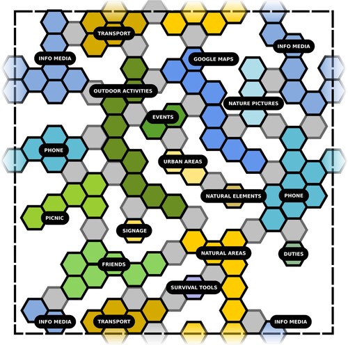
The ‘transport’ and ‘natural areas’ clusters in wrap around the map top-to-bottom. The ‘phone’ cluster wraps around left-to-right. The ‘info media’ cluster wraps around both top-to-bottom and left-to-right. The tiles that lie across the map boundary, represented by the dotted black line, are repeated on both sides and faded out. This is a practical shortcut meant to solve a visualization issue that relates to presenting the ecosystem through a flattened map. Alternative options include the use of several distinct partial maps and the rendering of the map as a spherical projection: both of these introduce additional problems, either by artificially decomposing the ecosystem in ad hoc parts, or by making the map less immediately readable.
Colours are used to highlight three different base channels, the ‘pervasive layers carrying information around the ecosystem’ (Resmini and Lacerda Citation2016, 20): yellow hues are used for clusters that belong to the ‘physical’ environment, blue hues for ‘digital’ clusters, and green hues for social/activity-related clusters. The existence and the number of seams between clusters that belong to different channels is an indicator of how easily or successfully people can blend information sources to support their experience. In Turku, the physical/digital integration is 6, but important parts of the physical environment, ‘signage’ for example, seem to be disconnected.
The map shows that the most sizable touchpoint category cluster is ‘info media’, comprising 16 tiles, meaning the category was mentioned 15 times across all journeys, and with an integration factor of 6. The ‘info media’ cluster includes social media, all kinds of digital applications and other ways to obtain information (for example the above-mentioned local apps CityNomadi, Retkipaikka, Palvelukartta, and Opaskartta belong to this group). The second largest cluster is the (mobile) ‘phone’ (13, with integration 7). Then we have ‘natural areas’ (which is usually the destination along with the ‘picnic’) at size 10 and integration 7, ‘transport’ at 9 and integration 5, and then the ‘Google maps’ cluster at size 8.
The contribution of a pervasive information architecture approach to a consistent everyday life
The urbanites’ everyday activities and routines in the twenty-first century happen in blended space (Benyon Citation2014) and have them engage with digital and physical information elements in the environment (Resmini and Lindenfalk Citation2021). In the case presented above, the blended space taken into consideration is that of enjoying the natural outdoors of the city, and a PIA approach was adopted to explore how specific groups of urbanites, immigrants, could be better supported through the identification of what elements would help them establish a more solid sense of place and belonging and contribute to making their use of digital and physical space a more unified and cohesive experience.
The results from the case show that the current approach to the design of urban natural spaces – in which physical signage, mobile apps, voice assistants, urban design components are not purposefully considered to be part of one single pervasive information environment – did not always help research participants enjoy the outdoors or learn more about the natural environment and the possible activities therein. This means that the information space within which the research participants carried out their activities was fragmented, and that cognitive, emotional, or physical hindrances interrupted at times the flow of information, making their journeys harder, longer, or plain impossible.
The formalization of PLR paths provided an effective way of visually showing how difficult a specific journey proved to be and where eventually the flow of information stopped, making the pieces of information necessary to achieve a certain goal (reaching a natural destination, in our case) unattainable. This introduced unnecessary cognitive load, required effort to overcome, and as a consequence forced research participants to either give up or find alternative and more demanding ways to proceed. These ‘make-or-break’ touchpoints in a journey identify possible leverage points, where changes can be introduced that support the urbanite’s needs and that sensibly considers the entirety of the digital/physical environment. In general, these paths also visually show that an urbanite’s journey usually consists of a complex choreography that can be more or less physically, emotionally, and cognitively demanding, depending on the type of resources the person needs, the elements present and attainable in the environment, and on how (dis)connected these are. A well-integrated experience ecosystem will better support a multiplicity of journeys; a badly integrated one, one where information flows between digital and physical touchpoints are frequently hindered or stopped altogether, will not.
Remote/weak touchpoints showed how using mobile apps or websites was often a difficult task for the interviewees, mostly in dependence of language barriers (lack of or insufficient knowledge of the Finnish language) and cognitive barriers (finding, downloading, and using relevant apps; finding the right information on the internet). The journey data contains 10 journeys where information flows are hindered by the presence of one or more of these barriers. Cultural and emotional barriers were also identified: some of the participants found Finnish forests scary and dangerous, others did not know how to dress for cold weather. This in addition to the already mentioned physical barriers related to not knowing how to handle icy or slippery roads during the harsh winter times.
The importance of digital applications in accessing natural places is shown by the number of instances of touchpoints related to ‘info media’, ‘Google maps’, ‘phones’, and ‘nature pictures’ in the ecosystem map, 40 in total (). Some of the participants did not know their neighbourhoods and the urban nature therein beyond what their routine demanded. Thus, they tried to rely on digital space (such as the internet, Google maps, mobile apps) to find information about natural places, or about what kind of activities were possible outdoors. While investigating their journeys, we found out how unfamiliarity with both the physical and the digital environments related to natural areas produced disorientation and, in few cases, deterred personal initiative and exploration. This clearly does not support establishing and maintaining a sense of place and belonging, which are essential to any placemaking intervention. To explore this further, additional observations were made that looked at the original data, the journeys, the PLR paths and ecosystem map in the light of the heuristics previously introduced ().
Figure 4. Experience ecosystem facets and pervasive information architecture heuristics.
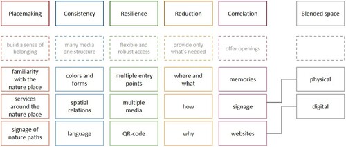
The participants’ placemaking was stronger when the natural area was already familiar to them (for example because their routine activities brought them there), or they had memories from their home countries that they could emotionally connect with their natural destination in the hosting country (correlation). On the other hand, lack of signage (or difficulties to understand the signs) or lack of services disoriented and discouraged them. The lack of services is of particular interest here: the need for clear indication of public transportations, or supermarkets in the vicinity showed how some of the research participants felt more comfortable when they could place the natural areas in an urban context. Other research participants highlighted the need to have QR-codes or similar scan-to-access entryways on signage and generally in the physical environment, leading to online information providing more details about the area offered in different languages (consistency and resilience). Indeed, they found some of the existing physical signage too information-rich, hard to parse and therefore not useful (reduction and consistency). The layout of the individual signs (including colours and forms) was also an important factor, and long textual descriptions were singled out as problematic and discouraging, suggesting that the use of text, images and colours should be revisited to facilitate way-finding and reduce disorientation (placemaking). This supports the notion that, if a PLR approach indicates that the blended space being explored does not properly offer support to the PIA heuristics, and especially placemaking, it is useful, as we did, to go back to the data to possibly identify the root of the problem.
Conclusions
The main objective of this study was to introduce a set of tools to carry out urban geography research by approaching urban space as a blended space. As a rich body of geographical work has shown, urban environments are becoming increasingly complex and digital and physical spaces are more and more intertwined in everyday urban life. For example, exploring the geographical dimensions of pervasive computing, Dodge, Kitchin, and Zook elaborated on why software matters in geography, and one of the reasons they found is that it is changing ‘the nature of everyday practices’ (Citation2009, 1283). In fact, not only has software made itself spatial: it is also literally making and producing (everyday) space. Thus, the very urban fabric results to be made of software. In a similar vein, Rose (Citation2017), in turn citing Ash, Kitchin, and Leszczynski (Citation2018), recalled that geographies are increasingly produced by the digital, which is reconfiguring how cities are made and experienced. Moreover, she continued, the digitally mediated city is also changing and affecting the humans’ very agency, by making it ‘always already (digitally) sociotechnical’ (Citation2017, 789). Non-representational geographies, actor-network theory and science and technology studies are among the growing bodies of work that Rose identified as exploring the current making of the digitally mediated cities.
Building upon this body of literature, in this article we argue that to disentangle such complexities systemic approaches are needed. They would allow us to increase our understanding of urban space as a blended space, how it is experienced and embodied by the urbanites, and what existing barriers, in either digital or physical space or in moving from one to the other, prevent people from accessing the information they need to successfully achieve their goals. Accordingly, the research implemented a pervasive information architecture framework to study how some urbanites from the immigrant population in Turku are informationally supported (or not) by the design of urban blended spaces in their accessing and using natural urban areas. The research was carried out to be actor-driven and citizen-centric, and to focus on human-information and human-environment interactions.
The article exposes the conceptual and methodological tools used in the Turku study to address the problem space as a blended space, by approaching urban space from a specific systemic perspective that does not separate digital technology from the natural or built environment, or any human activity (Hine Citation2015). If the city is a digital, ‘smarter’ city (Paskaleva and Cooper Citation2019), it seems just logical to study it as a complete information space, a blend of physical space and digital space, designed to facilitate and support the urbanites’ sense of place and belonging. For this purpose, we adopted a pervasive information architecture approach, a generative, heuristic framework for the co-creation and co-production of blended, digital/physical environments (experience ecosystems) where the entirety of an individual’s experience unfolds. The framework introduces placemaking, consistency, resilience, correlation, and reduction as medium-aspecific design heuristics that can be successfully used to support a person’s sense-making and sense of belonging. The heuristics identify the foundational elements that create a structure of meaningful relationships and information flows between people, artefacts, locations, and the activities possible therein. This approach promotes consistency across digital and physical spaces, better placemaking to support a sense of presence, and a high degree of correlation to support a proactive, explorative approach to the urban space.
The research brought to light a number of barriers, interruptions and deviations that make the existing information environment less than optimal, and that prevented some of the research participants from enjoying the natural urban areas in and around Turku. The Personal-Local-Remote paths and the ecosystem map allowed us to reflect first, formalize second, and identify third the touchpoints where physical, cognitive, cultural, or emotional barriers made a seam unpassable, stopped or disrupted the information flow, and as a consequence hampered or interrupted someone’s journey. For example, the paths made visible how the digital services supporting access to nature did not offer a way to integrate physical/outdoor activities and leisure and free time opportunities in one’s journey, thus generating frustration and disorientation. This resulted in people not being able to properly sense-make and place-make and thus failing to thoroughly enjoy the natural areas: some hiking paths for example remained unknown and mostly inaccessible.
Considering the increasingly complex informational nature of the city space, of which this study is only an example, a pervasive information architecture approach and its methodological set of tools (PLR-syntax) may be used as an inspiration for example by geographical research revisiting and updating classical time-geography concepts in digitally mediated cities and environments (Couclelis Citation2009; Shaw Citation2023). It not only suggests new designerly ways to formalize how urbanites navigate the blended urban space, but also helps evaluate how success or unsuccess in gathering information as well as the quality and hands-on nature of the information provided influence everyday activities in the urban. Of course, further research is needed in order to strengthen the theoretical and empirical link between PIA and urban geography, to design more consistent and resilient urban blended spaces and thus promote more inclusive access to urban areas.
Ethical statement
This research has been conducted according to the TENK (Finnish National Board on Research Integrity) and University of Turku’s Ethics Committee for Human Sciences guidelines. There is no research participant who may be identifiable through the manuscript.
Acknowledgements
A special thank you goes to Meiju Marttila for helping in the design phase of the paths and ecosystem.
Disclosure statement
No potential conflict of interest was reported by the author(s).
Additional information
Funding
References
- Amin, A., and N. Thrift. 2017. Seeing Like a City. Cambridge/Malden: Polity Press.
- Armson, R. 2011. Growing Wings on the Way: Systems Thinking for Messy Situations. Axminster: Triarchy Press Limited.
- Arthur, P., and R. Passini. 1992. Wayfinding: People, Signs, and Architecture. New York: McGraw-Hill.
- Ash, J., R. Kitchin, and A. Leszczynski. 2018. “Digital Turn, Digital Geographies?” Progress in Human Geography 42 (1): 25–43. doi:10.1177/0309132516664800.
- Bawden, D., and L. Robinson. 2020. “Information Overload: An Introduction.” In Oxford Research Encyclopedia of Politics, edited by D. Bawden and L. Robinson. Oxford: Oxford University Press.
- Benyon, D. 2014. Spaces of Interaction, Places for Experience. London: Morgan & Claypool.
- Benyon, D., and A. Resmini. 2017. “Electronic Workshops in Computing” Proceedings of the 31st British Computer Society Human Computer Interaction Conference 38: 1–12. https://doi.org/10.14236/ewic/HCI2017.38.
- Castells, M. 2009. The Power of Identity. Oxford: Wiley-Blackwell.
- Castells, M. 2010a. End of Millennium. Chichester: Wiley-Blackwell.
- Castells, M. 2010b. The Rise of the Network Society. Oxford: Wiley-Blackwell.
- Couclelis, H. 2009. “Rethinking Time Geography in the Information Age.” Environment and Planning A: Economy and Space 41 (7): 1556–1575. https://doi.org/10.1068/a4151.
- Covert, A. 2012. My IA Heuristics Journey. Accessed May 22, 2023 https://abbycovert.com/writing/ia-heuristics-journey.
- Davis, N. 2012. Information Architecture’s Two Schools of Thought. Accessed August 8, 2022. https://www.uxmatters.com/mt/archives/2012/11/information-architectures-two-schools-of-thought.php.
- De Certeau, M. 1984. The Practice of Everyday Life. Berkeley: University of California Press.
- DeNardis, L. 2020. The Internet in Everything: Freedom and Security in a World with No Off Switch. New Haven: Yale University Press. doi:10.12987/9780300249330
- Dodge, M., R. Kitchin, and M. Zook. 2009. “How Does Software Make Space? Exploring Some Geographical Dimensions of Pervasive Computing and Software Studies.” Environment and Planning A: Economy and Space 41 (6): 1283–1293. https://doi.org/10.1068/a42133.
- Ewing, S., J. M. McGowan, C. Speed, and V. C. Bernie, eds. 2016. Architecture and Field/Work. London: Routledge.
- Floridi, L. 2015. “Hyperhistory and the Philosophies of Information Policies.” In The Onlife Manifesto: Being Human in a Hyperconnected Era, edited by L. Floridi, 51–63. London: Springer. doi:10.1007/978-3-319-04093-6
- Gharajedaghi, J. 2011. Systems Thinking: Managing Chaos and Complexity: A Platform for Designing Business Architecture. San Francisco: Morgan Kaufmann.
- Greenfield, A. 2017. Radical Technologies. The Design of Everyday Life. London/New York: Verso.
- Grossman, J. 2006. Designing for Bridge Experiences. UX Matters. Accessed May 29, 2023. https://www.uxmatters.com/mt/archives/2006/06/designing-for-bridge-experiences.php.
- Haverty, M., and M. Bates. 2021. “Concepts for an Information Architecture of Time.” In Advances in Information Architecture, edited by A. Resmini, S. A. Rice, and B. Irizarry, 279–294. Cham: Springer.
- Hine, C. 2015. Ethnography for the Internet. Embedded, Embodied and Everyday. London: Bloomsbury.
- Jonsson, E. 2002. Inner Navigation: Why We Get Lost and How We Find Our Way. New York: Scribner.
- Kitchin, R. 1998. “Towards Geographies of Cyberspace.” Progress in Human Geography 22 (3): 385–406. https://doi.org/10.1191/030913298668331585.
- Kitchin, R., P. Cardullo, and C. Di Feliciantonio. 2019. “Citizenship, Justice, and the Right to the Smart City.” In The Right to the Smart City, edited by P. Cardullo, C. Di Feliciantonio, and R. Kitchin, 1–24. Bingley: Emerald Publishing Limited. doi:10.1108/978-1-78769-139-120191001
- Kitchin, R., and M. Dodge. 2014. Code/Space: Software and Everyday Life. Cambridge/London: MIT Press.
- Kwan, M.-P. 2002. “Time, Information Technologies, and the Geographies of Everyday Life.” Urban Geography 23 (5): 471–482. https://doi.org/10.2747/0272-3638.23.5.471.
- Latour, B. 2005. Reassembling the Social. An Introduction to Actor-Network Theory. Oxford: Oxford University Press.
- Lefebvre, H. 2004 [1992]. Rhythmanalysis. London/New York: Continuum.
- Lindenfalk, B., and A. Resmini. 2019. “Mapping an Ambient Assisted Living Service as a Seamful Cross-Channel Ecosystem.” In Service Design and Service Thinking in Healthcare and Hospital Management: Theory, Concepts, Practice, edited by M. Pfannstiel, and C. Rasche, 289–314. Cham: Springer. doi:10.1007/978-3-030-00749-2_17
- Lynch, K. 1960. The Image of the City. Cambridge/London: The MIT Press.
- Massey, D., and D. Wield. 2003. High-Tech Fantasies: Science Parks in Society, Science and Space. London/New York: Routledge.
- Nowell, L. S., J. M. Norris, D. E. White, and N. J. Moules. 2017. “Thematic Analysis.” International Journal of Qualitative Methods 16 (1). https://doi.org/10.1177/1609406917733847.
- O’Keefe, B., and D. Benyon. 2015. “Using the Blended Spaces Framework to Design Heritage Stories with Schoolchildren.” International Journal of Child-Computer Interaction 6: 7–16. https://doi.org/10.1016/j.ijcci.2016.02.001.
- Paskaleva, K., and I. Cooper. 2019. “Innovations in Co-Created Smart City Services.” In Setting Foundations for the Creation of Public Value in Smart Cities, edited by M.P.R. Bolivar, 165–195. Public Administration and Information Technology, vol. 35. Cham: Springer. doi:10.1007/978-3-319-98953-2_7
- Renzi, A.B. 2017. “UX Heuristics for Cross-Channel Interactive Scenarios.” In Design, User Experience, and Usability: Theory, Methodology, and Management. DUXU 2017, edited by A. Marcus, and W. Wang, 481–491. Lecture Notes in Computer Science, vol. 10288. Cham: Springer. doi:10.1007/978-3-319-58634-2_35
- Renzi, A. B., and O. Almeida. 2020. “UX Heuristic Evaluation of Cross-Channel Interaction Systems: First Experimentations.” Human Factors in Design 9 (17): 058–074. https://doi.org/10.5965/2316796309172020058.
- Resmini, A. 2021. “Classical to Contemporary: An M3-Based Model for Framing Change in Information Architecture.” In Advances in Information Architecture, edited by A. Resmini, S. A. Rice, and B. Irizarry, 9–17. Cham: Springer. doi:10.1007/978-3-030-63205-2
- Resmini, A., and F. Lacerda. 2016. “The Architecture of Cross-Channel Ecosystems” Proceedings of the 8th International Conference on Management of Digital EcoSystems, 17–21. doi:10.1145/3012071.3012087.
- Resmini, A., and B. Lindenfalk. 2021. “Mapping Experience Ecosystems as Emergent Actor-Created Spaces.” In Transactions on Large-Scale Data- and Knowledge-Centered Systems XLVII, edited by A. Hameurlain, A. M. Tjoa, and R. Chbeir, 1–28. Berlin/Heidelberg: Springer. doi:10.1007/978-3-662-62919-2_1
- Resmini, A., B. Lindenfalk, and J. Jauhiainen. 2023. “Being Elsewhere: An Information Architecture Approach to the Design of a Sense of Presence in XR Environments.” In Human-Computer Interaction. HCII 2023, edited by M. Kurosu, and A. Hashizume, 502–521. Lecture Notes in Computer Science, vol 14013. Cham: Springer. doi:10.1007/978-3-031-35602-5_36
- Resmini, A., B. Lindenfalk, L. Simeone, and D. Drabble. 2021. “Using PLR Syntax to Map Experience-Based Digital/Physical Ecosystems for Strategic Systemic Change.” In HCI International 2021 - Posters. HCII 2021, edited by C. Stephanidis, M. Antona, and S. Ntoa, 513–520. Communications in Computer and Information Science, vol 1421. Cham: Springer. doi:10.1007/978-3-030-78645-8_65
- Resmini, A., and L. Rosati. 2010. “The Semantic Environment: Heuristics for a Cross-Context Human–Information Interaction Model.” In The Engineering of Mixed Reality Systems, edited by E. Dubois, P. Gray, and L. Nigay, 79–99. Cham: Springer. doi:10.1007/978-1-84882-733-2_5
- Resmini, A., and L. Rosati. 2011. Pervasive Information Architecture: Designing Cross-Channel User Experiences. San Francisco: Morgan Kaufmann Publishers Inc.
- Robertson, S. 2008. “Cultural Probes in Transmigrant Research: A Case Study.” InterActions: UCLA Journal of Education and Information Studies 4 (2): 1–26. https://doi.org/10.5070/D442000625.
- Rosati, L. 2020. Come l’architettura dell’informazione plasma l’esperienza: La storia del Vietnam Veterans Memorial [How Information Architecture Shapes Experience: The History of Vietnam Veterans Memorial]. Accessed May 29, 2023. https://www.lucarosati.it/blog/architettura-informazione-esperienza.
- Rosati, L., A. Schena, and R. Massacesi. 2014. “Cross-Channel Design for Cultural Institutions—The Istituto Degli Innocenti in Florence.” In Reframing Information Architecture, edited by A. Resmini, 145–156. Cham: Springer. doi:10.1007/978-3-319-06492-5_11
- Rose, G. 2017. “Posthuman Agency in the Digitally Mediated City: Exteriorization, Individuation, Reinvention.” Annals of the American Association of Geographers 107 (4): 779–793. https://doi.org/10.1080/24694452.2016.1270195.
- Ryan, M.-L., K. Foote, and M. Azaryhau. 2016. Narrating Space / Spatializing Narrative: Where Narrative Theory and Geography Meet. Columbus: Ohio State University Press.
- Salingaros, N. A. 1999. “Urban Space and Its Information Field.” Journal of Urban Design 4 (1): 29–49. https://doi.org/10.1080/13574809908724437.
- Schreeder, A., A. Van Deursen, and V. Dijk. 2017. “Determinants of Internet Skills, Uses and Outcomes. A Systematic Review of the Second- and Third-Level Digital Divide.” Telematics and Informatics 34 (8): 1607–1624. https://doi.org/10.1016/j.tele.2017.07.007.
- Sharifi, A., R. Srivastava, N. Singh, R. Tomar, and M.A. Raji. 2022. “Recent Advances in Smart Cities and Urban Resilience and the Need for Resilient Smart Cities.” In Resilient Smart Cities, edited by A. Sharifi, and P. Salehi, 17–37. The Urban Book Series. Cham: Springer. doi:10.1007/978-3-030-95037-8_2
- Shaw, S. L. 2023. “Time Geography in a Hybrid Physical–Virtual World.” Journal of Geographical Systems 25: 339–356. https://doi.org/10.1007/s10109-023-00407-y.
- Southworth, M., G. Cranz, G. Lindsay, and L. Morhayim. 2012. “People in the Design of Urban Places.” Journal of Urban Design 17 (4): 461–465. https://doi.org/10.1080/13574809.2012.720757.
- Spinney, J. 2010. “Improvising Rhythms: Re-Reading Urban Time and Space Through Everyday Practices of Cycling.” In Geographies of Rhythm. Nature, Place, Mobilities and Bodies, edited by T. Edensor, 113–127. Farnham: Ashgate. doi:10.4324/9781315584430
- Statistics Finland. 2020a. Immigrants and Integration. Numbers and Shares of Persons With Immigrant Background by Area 1990-2020. Accessed December 8, 2021. https://pxnet2.stat.fi/PXWeb/pxweb/en/Maahanmuuttajat_ja_kotoutuminen/Maahanmuuttajat_ja_kotoutuminen__Maahanmuuttajat_ja_kotoutuminen/maakoto_pxt_11vu.px.
- Statistics Finland. 2020b. Population Structure. Language According to Sex by Municipality. Accessed December 8, 2021. https://pxnet2.stat.fi/PXWeb/pxweb/en/StatFin/StatFin__vrm__vaerak/statfin_vaerak_pxt_11rm.px.
- Tedeschi, M. 2019. Crime, Bodies and Space. Towards an Ethical Approach to Urban Policies in the Information Age. London: Routledge. http://dx.medra.org/10.17418planext.2016.2vol.02.
- Tedeschi, M. 2022. “Embracing Difference: On law, Code and Space.” Culture, Theory and Critique 63 (1): 26–42. https://doi.org/10.1080/14735784.2023.2190902.
- Tedeschi, M., and K. Gadd. 2021. “On Multiple Spacetimes in the Everyday Lives of Irregular Migrants in Finland.” The Geographical Journal 187 (2): 127–137. https://doi.org/10.1111/geoj.12378.
- Tedeschi, M., H. Heino, J. Jämsä, and A. Klemettilä. 2022. “The Multidimensionality of Urban Nature: The Well-Being and Integration of Immigrants in Finland.” Urban Forestry & Urban Greening 74: 127645. https://doi.org/10.1016/j.ufug.2022.127645.
- Thulin, E., and B. Vilhelmson. 2012. “The Virtualization of Urban Young People's Mobility Practices: A Time-Geographic Typology.” Geografiska Annaler: Series B, Human Geography 94 (4): 391–403. https://doi.org/10.1111/geob.12005.
- Tversky, B. 2019. Mind in Motion: How Action Shapes Thought. New York: Basic Books.
- Valentini, D., A. M. Lorusso, and A. Stephan. 2020. “Onlife Extremism: Dynamic Integration of Digital and Physical Spaces in Radicalization.” Frontiers in Psychology 11: 524. https://doi.org/10.3389/fpsyg.2020.00524.
- Whyte, W. H. 1988. City: Rediscovering the Center. Garden City: Doubleday.
- Wood, M. A. 2021. “Rethinking How Technologies Harm.” The British Journal of Criminology 61 (3): 627–647. https://doi.org/10.1093/bjc/azaa074.