Abstract
Since its establishment in the 1890s, the Canadian National Hydrometric Network (CNHN) has become the main source of water information for various users across the country. The CNHN provides the essential information and data on the status of one of the most precious natural resources of Canada: its surface water resources. However, the CNHN has never been evaluated based on international standards such as the World Meteorological Organization (WMO) guidelines for hydrometric network density. This preliminary analysis aims to fill that gap and provide background information on CNHN density. In this study, the CNHN is evaluated using WMO (2008) guidelines as a benchmark. Spatial analysis techniques are applied to determine the areas that meet the WMO (2008) minimum network density standards and those that do not meet the minimum standards. It was found that only about 12% of the Canadian terrestrial area is covered by hydrometric networks that meet the WMO (2008) minimum standards, while 49% of the terrestrial area is poorly gauged and about 39% is ungauged. The poorly gauged and ungauged areas are largely located in the mountainous and northern regions. Only a few spots in the southern parts of the country have a streamflow network density that meets the WMO (2008) minimum recommendation. An estimated total of about 5041 new stations are needed to bring the CNHN up to WMO (2008) minimum standard level. The study results clearly confirm the necessity to continue operating all existing streamflow stations and the need to add new streamflow stations. However, further analysis is required to optimize the CNHN at the regional scale by accounting for other factors such as population density, specific needs and economic constraints.
Résumé:
Depuis son établissement en 1890, le Réseau Hydrométrique National du Canada (RHNC) est vite devenu la première source d’information sur l’eau pour divers usagers à travers le pays. Le RHNC fournit les données et l’information essentielle sur l’état de l’une des resources les plus précieuses du Canada: les resources hydriques. Cependant, la densité du RHNC n’a jamais été évaluée sur la base de standards internationaux tels que ceux de l’Organisation Météorologique Mondiale (OMM). Cette étude préliminaire a pour objectif de combler ce vide. Dans cette étude, le RHNC est évalué sur la base des nouvelles recommendations de l’OMM 2008. Des techniques d’analyse spatiale sont appliquées pour determiner les regions dont le réseau hydrométrique est au deça ou au delà du standard minimum de l’OMM en terme de densité du réseau. Les résultats de l’analyse indiquent que seulement 12% du territoire terrestre Canadien est couvert de reseau hydrométrique qui remplit les standards de l’OMM. Mais pour environ 49% du territoire le réseau est au deça des normes de l’OMM, et pour 39% du territoire il n’y a même pas de réseau hydrométrique. Les regions sans réseau ou au réseau déficient sont situées largement dans les zones montagneuses et au nord du pays. Seulement quelques zones dans la partie sud du pays ont un réseau qui satisfait les normes de l’OMM. Il a été estimé qu’environ 5041 nouvelles stations sont nécessaires pour amener le RHNC au niveau du standard minimum de l’OMM. Les résultats de cette étude indiquent clairement la nécessité de maintenir toutes les stations actuelles et le besoin d’ajouter de nouvelles stations. Cependant, une analyse plus approfondie est requise pour optimiser le RHNC à l’échelle régionale en tenant compte des aspects tels que la densité de la population, les besoins spécifiques, et les contraintes économiques. Des recommendations sont proposées pour l’optimisation du RHNC.
Introduction
It is now well established that the importance of water information provided by hydrometric networks increases with national social and economic development due to more precise and specialized water information needs. Establishing and maintaining an adequate hydrometric network remains a major challenge in most countries around the world including Canada. The Canadian National Hydrometric Network (CNHN) has grown since its establishment in the 1890s, but has also suffered from many reductions through the course of its development (Mishra and Coulibaly Citation2009). In a recent analysis of Canadian hydrometric networks (Mishra and Coulibaly Citation2010), it was found that most watersheds in northern Canada remain largely ungauged, while the southernmost populated catchments remain poorly equipped. Although some provincial agencies and regional conservation authorities appear very concerned by the inadequate hydrometric network, there is no clear indication of significant increase in the network density over the last few decades. It is also unclear whether the CNHN meets the minimum network density recommended by the World Meteorological Organization (WMO) guidelines (WMO Citation2008). In a recent review of Canadian national hydrometric networks and water quality networks, the Auditor General of Canada called for an evaluation of national water monitoring networks and the determination of the optimum number of water monitoring stations across Canada, to ensure that adequate and reliable water information is collected for the various users [Office of the Auditor General of Canada (OAGC) Citation2010].
The main objective of this study is to evaluate the CNHN density versus the WMO (Citation2008) standards or guidelines. This includes identifying areas with network density that meet the minimum standards and those that have a lower density than the minimum WMO (Citation2008) standards (i.e., those that do not meet the minimum standards), determining the number of additional stations needed to meet the WMO (Citation2008) standards, and providing some recommendations on how to optimize the CNHN density. Detailed methodology and results of the study are presented in an unpublished technical report (Coulibaly and Samuel Citation2011). A key advantage of analyzing the CNHN vs. WMO standards is to obtain useful background information where human needs, population density and economic constraints are not the drivers of the analysis. However, this suggests that the analysis results should be used with caution given that the WMO guidelines rely only on physiographic units.
Methods
Refining physiographic units
The entire hydrometric network database available from Water Survey of Canada was collected along with available information on physiographic units from Agriculture and Agri-Food Canada. The data were pre-processed to ensure consistency. The WMO (Citation2008) standards for minimum network density are based on physiographic units. Therefore, all the Canadian eco-districts were first classified based on their physiographic units. The basic unit used in the analysis is the eco-district, which is defined as a part of an eco-region characterized by distinctive assemblages of relief, geology, landforms and soils, vegetation, water, fauna and land use. The eco-districts bring together various sub-regional units which have been defined by Environment Canada, Agriculture and Agri-Food Canada, and various provincial agencies (Ecological Stratification Working Group Citation1996).
Given that the Canadian classification of the physiographic units of the eco-districts is slightly different from the one used by WMO (Citation2008), a regrouping and matching of some of the physiographic units was done as shown in Table . For example, the three units defined as “plain”, “organic wetland” and “plateau” were regrouped to match “interior plains” as defined by WMO (Citation2008) (Table ). Similar regrouping was done for other physiographic units of the eco-districts. Table also shows the number of eco-districts, the spatial area covered and the mean elevation. It should be noted that the eight eco-districts located in the Hudson Bay and classified as “interior plains” were removed for consistency and to avoid any bias in the statistics. Therefore, the total number of eco-districts used in the analysis is 1017. Precisely, a total of 608 eco-districts were classified as interior plains – covering about 60% of Canadian land area – while 166 and 243 eco-districts were classified as mountainous and hilly/undulating – covering about 20% of Canadian land area, respectively (Table ).
Table 1. Regrouping and matching of the classifications of physiographic units of eco-districts as defined by Environment Canada-Agriculture Canada and WMO (Citation2008), respectively.
It is also noteworthy that some of the WMO physiographic units (“coastal”, “small areas” and “polar/arid”) were used in the analysis because these were not components of the Canadian classification system. For example, in the Canadian classification system, a coastal area can be defined as “mountainous” or “scarp” based on its actual physiography, whereas WMO (Citation2008) guidelines classify all ocean or sea shores as “coastal”. Therefore, instead of using “coastal” as physiographic unit, the actual specific unit (e.g. “mountainous” or “scarp”) was used accordingly. This allowed a finer and better classification of all the eco-districts.
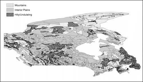
The spatial distribution of the physiographic units used in the analysis is shown in Figure . It appears that the Canadian landscape is dominated by “interior plains”, followed by “mountains” and “hilly/undulating” physiographic units (Figure ).
Figure 1 Spatial distribution of the physiographic units used in this analysis.
Canadian National Hydrometric Network (CNHN) data processing
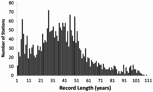
National hydrometric network data are routinely collected and compiled by Water Survey of Canada (WSC, Environment Canada). The information is housed in two centrally-managed databases: HYDEX (which contains information about the various streamflow, water level, and sediment stations) and HYDAT (which contains the actual data for the stations listed in HYDEX). All the data used in this study were obtained from WSC and are available at http://www.ec.gc.ca/rhc-wsc/default.asp?lang=En&n=9018B5EC-1. There are about 2738 active water level and streamflow stations operated by WSC; however, 30 of these are international gauging stations. Therefore, the number of total active streamflow stations used in this study was 2708. Discontinued hydrometric stations were not used. Record lengths of active streamflow stations vary from 1 to 150 years (from November 2011 datum). Figure shows the number of active stations as a function of their record length. Most stations have a record length in the range of 21 to 51 years. The total number of stations has fluctuated over time, reaching a peak in 1980s (Mishra and Coulibaly 2009).
Figure 2 Record length of active hydrometric stations (dated November 2011).
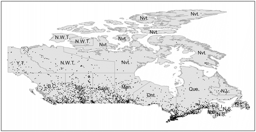
The spatial distribution of the active stream gauges is shown in Figure . Most of the stations are located in the southern parts of Canada, and the number of stations decreases significantly towards the north (Figure ).
Figure 3 Spatial distribution of active streamflow stations across Canada in 2011.
Spatial analysis of the CNHN density
Information/data from a total 1017 eco-districts and 2708 active hydrometric stations were collected and tabulated based on physiographic units and the number of existing stations in each eco-district. The data were then analyzed in a geographical information system (GIS) using a classification algorithm (a tool available in ArcGIS for merging all eco-district shapefiles having the same physiographic unit), to automatically regroup and match Canadian physiographic units to the WMO (Citation2008) standard units used for defining minimum network density for streamflow stations.
A field calculator tool available in ArcGIS was applied to determine the areas that meet the WMO (Citation2008) minimum network standards and those that do not meet the minimum standards. The areas that do not meet the minimum standards were further divided into two classes: (1) areas which are equipped with stream gauges, but still do not meet the WMO minimum requirements, and (2) areas that are simply ungauged. This analysis was performed for each eco-district. The analysis results were then interpolated across the entire country to develop general maps of the national hydrometric network density and detailed maps for each of the 15 ecozones and the 13 provinces across Canada.
In addition, a spatial analysis algorithm (i.e., a Fortran code linked to each ecozone ArcGIS shapefile) was developed and applied to estimate the number of additional stations needed in each ecozone to meet the WMO (Citation2008) minimum network density. First, the computation was done for each eco-district to determine the number of stations that should be added to meet the WMO (Citation2008) minimum standards. Second, the results of eco-districts within the same ecozone were aggregated to estimate the total number of stations that should be added to meet the WMO (Citation2008) minimum standards for each ecozone.
Results
The spatial distribution of areas that meet and those that do not meet the WMO (2008) minimum standards is shown in Figure , while the statistics are presented in Table . Although 70% of all active streamflow stations are installed in the interior plains, only 188 eco-districts (∼18.5%) have a hydrometric network density that meets the WMO (Citation2008) minimum standards, while for all the others (∼420 eco-districts) the network density does not meet the WMO standards (Table ). The number of stations in the mountainous and hilly/undulating regions is 6 and 4 times lower, respectively, than those in the interior plains. Thus, only 14 eco-districts (∼1.5%) and 64 eco-districts (∼6.3%) meet the WMO (Citation2008) standards in the mountainous and hilly/undulating regions, respectively (Table ).
Figure 4 Spatial distribution of areas that meet and those that do not meet the WMO (Citation2008) minimum standards with provincial boundaries.
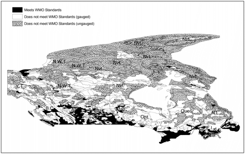
Table 2. Number of eco-districts and areas (and their percentages) that meet/do not meet the WMO (Citation2008) minimum standards.
In general, among the 1017 eco-districts, about 266 (∼26%) meet the WMO (Citation2008) standards, which represents about 12% of the total terrestrial area of Canada (Table ). About 309 eco-districts (∼30%) covering about 49% of total terrestrial area are poorly gauged and do not meet the WMO (Citation2008) standards, whereas 442 eco-districts (∼43%) covering about 38% of total area are simply ungauged (Table ). Overall, it can be seen that the northern regions are mostly ungauged or poorly gauged, while the central regions including the vast region around Hudson Bay are mostly poorly gauged (Figure ). The areas that meet the WMO (Citation2008) standards are mostly in the southern regions; however, they are often surrounded by areas that are poorly gauged (Figure ).
Although this analysis did not include the privately owned streamflow stations, it is interesting to evaluate the results per province (Figure ). It appears that all eco-districts in the Northwest Territories, Yukon, and Nunavut are largely ungauged. Most of the eco-districts in northern Quebec and northern Newfoundland are ungauged and all the remaining are poorly gauged. Northern eco-districts in British Columbia, Alberta, Saskatchewan, and Manitoba are either ungauged or poorly gauged, but they are all consistently below the WMO (Citation2008) standards (Figure ). The northern and central regions of Ontario are dominated by poorly gauged eco-districts. Those results are consistent with those recently shown by Mishra and Coulibaly (Citation2010). Only small areas in southern regions of Ontario, British Columbia, Alberta, Manitoba, Saskatchewan, and Newfoundland have hydrometric networks that meet the WMO minimum standards.
To further assess the spatial distribution of the hydrometric network density, a map is provided for the 15 terrestrial ecozones of Canada (Figure ). Detailed statistics are provided in Table . Among the 15 ecozones, only three ecozones (#8: Mixedwood Plains, #10: Prairies, #14: Montane Cordillera) are dominated by eco-districts that meet the WMO (Citation2008) standards (Table ). It can also be noted that 50% of the eco-districts in ecozone #7 (Atlantic-Maritime) meet the WMO (2008) standards. All other ecozones are dominated by eco-districts that are poorly gauged or ungauged but all below the WMO (2008) standards (Figure and Table ). Specifically, ecozones #2 (Northern Arctic), #5 (Taiga Shield), #6, (Boreal Shield), #11 (Taiga Cordillera) and #12 (Boreal Cordillera) are largely dominated by eco-districts that do not meet the WMO (Citation2008) minimum standards (Table ). It also appears from Figure that the spatial distribution of existing stations is not optimal.
Figure 5 Spatial distribution of areas that meet and those that do not meet the WMO (Citation2008) minimum standards within each Canadian ecozone along with spatial distribution of stations.
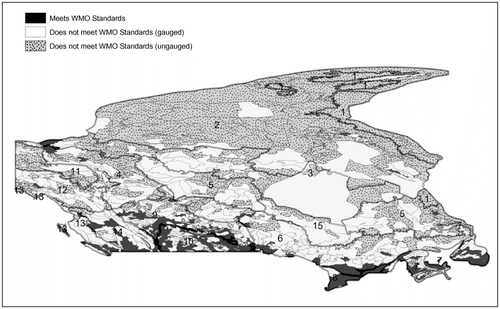
Table 3. Evaluation of network density per ecozone and estimated number of new stations.
Table 4. Evaluation of hydrometric network density for all physiographic units per ecozone.
An estimated total of about 5041 new stations is needed to bring the CNHN to WMO (Citation2008) minimum standard level (Table ). The number of new stations needed in each ecozone is indicated in Table . It appears that ecozones #1, #2, #3, #5, #6, #11, and #12 should be considered as areas with large gaps and priority areas whenever new stations become available. Overall, all ecozones need additional stations to meet the WMO (Citation2008) minimum standards. However, ecozones #8 and #10 need a lower number of additional stations and may simply require an optimization of the locations of existing stations.
It is important to emphasize that the WMO standards have some limitations given that they do not account for many important factors (e.g., social needs, economic constraints, population density and others); they rely only on physiographic units. Therefore, the analysis results should be used with caution. The estimated number of additional stations is based on WMO (Citation2008) guidelines and does not account for local or regional needs and/or water vulnerability indicators. It is anticipated that an optimization of the locations of existing stations may decrease the number of stations needed to meet the WMO (Citation2008) minimum standards. Furthermore, to obtain an optimal network, further analysis is required at the regional scale to account for other factors (e.g., specific needs, population density, etc.). However, this typically requires more complex analysis including a dual entropy-multiobjective optimization technique to identify the optimum locations for existing stations, and the optimal number of new stations and their locations. Such analysis should include discontinued stations. Future research will address this complex issue.
Conclusions
This study evaluated the density of the CNHN using the WMO (Citation2008) guidelines as a benchmark. The analysis was conducted in each eco-district, and the results evaluated from the eco-district scale to the ecozone and provincial scales. It was found that only about 12% of Canadian terrestrial area is covered by hydrometric networks that meet the WMO (Citation2008) minimum standards, while 49% of the terrestrial area is poorly gauged and about 39% is ungauged. Specifically, in mountainous areas only 14 out the 347 eco-districts meet WMO (Citation2008) standards, whereas in interior plains 188 out of 1876 eco-districts meet the WMO (Citation2008) standards. In hilly/undulating areas, 64 of the 484 eco-districts meet the WMO standards. At the ecozone scale, all 15 Canadian ecozones (i.e. Arctic Cordillera, Northern Arctic, Southern Arctic, Taiga Plains, Taiga Shield, Boreal Shield, Atlantic Maritime, Mixedwood Plains, Boreal Plains, Prairies, Taiga Cordillera, Boreal Cordillera, Pacific Maritime, Montane Cordillera and Hudson Plains) need additional stations to meet the WMO (Citation2008) minimum network density standards. The most critical areas with large gaps were identified in ecozones #1, #2, #3, #5, #6, #11, and #12 (Arctic Cordillera, Northern Arctic, Southern Arctic, Taiga Shield, Boreal Shield, Taiga Cordillera and Boreal Cordillera, respectively), while ecozones #8, #10, and #14 (Mixedwood Plains, Prairies and Montane Cordillera, respectively) were found to require lower numbers of additional stations. Although the analysis results provide useful background information for future work on optimizing the CNHN, they should be used with caution given that the WMO guidelines rely only on physiographic units.
Similarly, at the provincial scale, it was found that all the eco-districts in the Northwest Territories, Yukon, and Nunavut are largely ungauged. Whatever the province, most of the eco-districts in northern regions are either ungauged or poorly gauged, but they are all consistently below the WMO (Citation2008) standards. Only small areas in southern regions of Ontario, British Columbia, Alberta, Manitoba, Saskatchewan, and Newfoundland have hydrometric networks that meet the WMO minimum standards.
The study results clearly demonstrate the necessity of continuing to operate all existing streamflow stations as well as the need to add new streamflow stations, especially in northern and mountainous areas. An estimated total of about 5041 new hydrometric stations is needed to upgrade the CNHN to the WMO (Citation2008) standards. Given that the spatial distribution of existing stations was found to be non-optimal (Mishra and Coulibaly Citation2010), it is anticipated that an optimization of the locations of existing stations could reduce the total number of stations needed to meet the WMO (Citation2008) standards.
Therefore, it is recommended that:
| • | the focus should be to establish a CNHN that meets the WMO minimum standards; | ||||
| • | the spatial distribution of existing stations should be optimized to reduce the number of new stations needed in some ecozones; and | ||||
| • | the design of optimum network in eco-districts that meet the WMO minimum standards should be conducted to free up stations that can be relocated in poorly gauged or ungauged areas. | ||||
| • | Further study including the above recommendations should be undertaken to identify the optimum number of stations and the adequate locations to meet the WMO (Citation2008) minimum standards at a reduced cost. The application of the proposed recommendations can significantly reduce the number of additional stations needed to upgrade the CNHN to the WMO (Citation2008) minimum network standards. | ||||
Acknowledgements
This work was supported by Water Survey of Canada, Environment Canada. The authors are grateful to Erika Klyszejko (Water Survey of Canada) and Judy Kwan (Meteorological Service of Canada) for their valuable inputs and for providing additional information on the streamflow stations and the physiographic units. The authors are also grateful to two reviewers for their comments that helped to improve the initial manuscript.
Notes
Member of CWRA
References
- Coulibaly, P., and J. Samuel. 2011. Evaluation of Canadian National Hydrometric Network Density vs. WMO 2008 Standards. Final Project Report, Unpublished, Prepared for Water Survey of Canada, Environment Canada. McMaster University, Canada.
- Ecological Stratification Working Group. 1996. A National Ecological Framework for Canada. Ottawa Environment Canada.
- Mishra, A.K., and P. Coulibaly. 2009. “Development in Hydrometric Networks Design: A Review”. Reviews of Geophysics 47: RG2001. doi: 10.1029/2007RG000243.
- Mishra , A.K. and Coulibaly , P. 2010 . Hydrometric Network Evaluation for Canadian Watersheds . Journal of Hydrology , 380 : 420 – 437 .
- Office of the Auditor General of Canada (OAGC). 2010. Report of the Commissioner of the Environment and Sustainable Development. Chapter 2: Monitoring Water Resources. http://www.oagbvg.gc.ca/internet/English/parl_cesd_201012_02_e_34425.html
- World Meteorological Organization (WMO). 2008. Guide to Hydrological Practices, Vol. I: Hydrology – From Measurement to Hydrological Information. Sixth edition. Geneva, Switzerland: WMO No 168.