Abstract
A study was conducted to assess the farm financial impact and risk of two irrigation expansion scenarios based on the potential for water supply deficits in the irrigation districts of southern Alberta. The Irrigation Demand Model (IDM) was used to determine irrigation water demand based on annual crop water requirements, crop mix, irrigation system types and application efficiencies, irrigation district infrastructure, and the level of irrigation management within each irrigation block defined in the Water Resources Management Model (WRMM). Irrigation water supply values each year were then established for each irrigation block using the WRMM. The Farm Financial Impact and Risk Model (FFIRM), a farm financial simulation model that tracks farm finances (assets and liabilities) with time, subject to variability in crop water demand and crop prices, was used to determine the optimum allocation of water among fields within each farm operation during years of water supply deficits. Three scenarios were examined with the FFIRM – a baseline scenario and two irrigation expansion scenarios. Irrigation expansion was found to have negligible or very small adverse impacts on the financial well-being of typical farms in all six irrigation regions. Representative farms experienced essentially no change in net farm income (NFI) in the recent expansion (EXP1) scenario, and very small reductions in NFI in the future expansion (EXP2) scenario. Water conserved through irrigation efficiency gains in the next decade will likely offset the increased risk of negative impacts on NFI with irrigation expansion to the current limit.
Résumé
Une étude a été menée afin d’évaluer l’impact financière sur les fermes et le risque de deux scénarios extension de l’irrigation basé sur le potentiel de déficits d’approvisionnement en eau dans les périmètres irrigués du sud de l’Alberta. Le modèle de la demande d’irrigation (IDM) a été utilisée pour déterminer la demande en eau d’irrigation basé sur les be-soins annuels en eau des cultures, mélange des cultures, les types de systèmes d’irrigation et de l’efficacité des applications, de l’infrastructure district d’irrigation, et le niveau de gestion de l’irrigation dans chaque bloc d’irrigation défini dans les ressources en eau modèle de gestion (WRMM). Les valeurs d’alimentation en eau d’irrigation chaque année ont ensuite été mis es en place pour chaque bloc d’irrigation utilisant le WRMM. L’impact financière sur les fermes et risque de modèle (FFIRM), un modèle de simulation financière du secteur agricole qui permet de suivre les finances agricoles (actifs et passifs) avec le sujet de temps à la variabilité de la demande en eau des cultures et des prix des produits agricoles, a été utilisé pour déterminer la répartition optimale de l’eau au milieu des champs à l’intérieur chaque exploitation agricole au cours des années de déficits d’approvisionnement en eau. Trois scénarios ont été étudiés avec le FFIRM – un scénario de référence et deux scénarios extension de l’irrigation. Le développement de l’irrigation a été trouvé d’avoir négligeables ou très petits impacts négatifs sur le bien-être financier des fermes typiques dans toutes les six régions d’irrigation. Les fermes représentatives connu pratiquement aucun changement dans le revenu agricole net (NFI) dans l’expansion récente (EXP1) scénario et des réductions très petites NFI dans l’expansion future (EXP2) scénario. L’eau conservée grâce à des gains d’efficience d’irrigation dans la prochaine décennie sera probablement compenser le risque accru d’effets négatifs sur le NFI avec expansion de l’irrigation à la limite actuelle.
Introduction
Irrigation is vital to the agricultural economy in southern Alberta, and irrigated agriculture is a key driver for the rural economy elsewhere in Alberta and western Canada (Toma and Bouma Management Consultants Citation2007). About 97% of the irrigated land in Alberta is within the South Saskatchewan River Basin (SSRB) where approximately 500,000 ha of land are currently irrigated in 13 irrigation districts and another 100,000 ha are irrigated in private irrigation projects. Irrigated land is used to produce forages, cereal grains, oilseeds, and a variety of specialty crops. Irrigation also supports integrated livestock- and poultry-feeding and food-processing industries.
The median annual natural flow volume from the SSRB in Alberta is about 8.8 billion m3 and the current licensed allocation for the irrigation districts is 3.45 billion m3. At least 50% of the annual natural river flow that originates in Alberta must be passed to Saskatchewan under a Master Agreement on Apportionment. Water management infrastructure in the SSRB includes more than 50 storage reservoirs with a live storage capacity of about 3 billion m3. During the last decade, irrigation districts have diverted a mean gross diversion volume of about 1.9 billion m3, with annual gross diversion volumes ranging from 1.0 to 2.8 billion m3 (Alberta Agriculture and Rural Development Citation2012). Competition for water has increased in the SSRB during the past few decades through population growth and economic development, which resulted in the recommendation to close the Bow, Oldman, and South Saskatchewan sub-basins in the SSRB to additional water allocations (Alberta Environment Citation2006).
The irrigated area within the 13 irrigation districts has increased gradually since the early part of the twentieth century, with accelerated growth in the 1970s and 1980s (Alberta Agriculture and Rural Development Citation2012). Expansion limits were established for all of the irrigation districts in 1991 (Government of Alberta Citation1991) and a process for additional expansion was established through the Irrigation Districts Act in 1999 (Government of Alberta Citation1999). The 1991 expansion limit for the irrigation districts was 533,785 ha, with an increase in the limit to 558,236 ha by 2009. Expansion has been possible within existing licensed allocations because average diversions for irrigation have been reduced by about one-third during the last 20 years (AECOM Citation2009).
Expansion of the irrigated area by up to 10% in the Oldman Basin and by 10 to 20% in the Bow Basin was considered sustainable based on 1999 irrigation infrastructure, crop mix, on-farm irrigation system mix, and projected irrigation management practices (Irrigation Water Management Study Committee Citation2002). Recent plebiscites have authorized irrigation expansion in the Oldman River Basin of 20,235 ha in the Lethbridge Northern Irrigation District in 2010, 4000 ha in the Taber Irrigation District in 2011, and 16,000 ha in the Saint Mary River Irrigation District in 2011. A plebiscite in the Bow River Basin authorized irrigation expansion of 11,330 ha in the Bow River Irrigation District in 2012. Irrigation district infrastructure enhancements since 1999 and concurrent investments in more efficient on-farm irrigation systems have substantially increased water conveyance and on-farm irrigation system application efficiencies (AECOM 2009). Water savings from improved efficiencies of water management and operations in irrigation districts may be used to increase expansion limits within existing licensed water allocations (Government of Alberta Citation1991, Citation1999).
The purpose of this study was to assess the farm financial impact and risk of two irrigation expansion scenarios based on current farm finances and the potential for water supply deficits in the irrigation districts of southern Alberta. Factors that have changed since earlier farm financial impacts of irrigation expansion in Alberta were assessed include: irrigation district infrastructure; on-farm irrigation system and crop mixes; capital and operating costs, land values and crop prices; crop yield and water requirement relationships (Bennett and Harms Citation2011); and historical water supply data (1928 to 2001).
Methods
Farm financial impact and risk model
The Farm Financial Impact and Risk Model (FFIRM) is a dynamic farm financial simulation model developed in MS Excel that tracks farm finances (assets and liabilities) subject to variability in crop water demand and crop prices. The main variable investigated with the FFIRM was water supply, which was altered for each scenario while most other variables that could affect the analysis were held constant. A water allocation optimization component is included in the FFIRM to determine the optimum allocation of water among fields within each farm operation to maximize annual farm revenue from water supplies available for irrigation in any given year. The FFIRM was initially developed as part of the Irrigation in the 21st Century study (Heikkila et al. Citation2002).
Irrigation regions and weather data
Six irrigation regions were selected within the irrigation districts in southern Alberta to assess the farm financial impacts and risk of two irrigation expansion scenarios. The Glenwood-Magrath, Lethbridge-Picture Butte and Taber-Bow Island regions were selected in the Oldman River Basin, and the Vauxhall, Strathmore and Brooks-Gleichen regions were chosen in the Bow River Basin (Figure ).
Figure 1 Township weather data used to determine crop water demand and water supplies available for irrigation in the six irrigation regions.
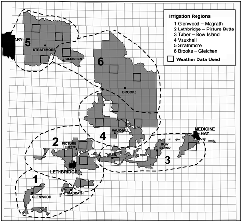
Irrigation regions were differentiated based on length of growing season, annual evaporative demand, potential precipitation, and similar crop production characteristics. Weather data for each irrigation region were selected from the provincial township weather dataset (Figure ; Shen et al. Citation2001; Alberta Agriculture and Rural Development Citation2009). Daily average values were calculated for weather data from the two to four townships selected in each irrigation region.
Weather data from 1928 to 2001 (74 years) were used to determine seasonal potential evapotranspiration (ETp) and cumulative precipitation from 1 May to 30 September for perennial forages and 15 May until harvest (based on cumulative growing-degree days) for all annual crops each year. The Priestley-Taylor method (Jensen et al. Citation1990) was used to estimate ETp with alfalfa as the reference crop. Seasonal crop evapotranspiration (ETc) was then calculated for each year using locally-derived crop coefficients for 11 irrigated crops (Bennett and Harms Citation2011).
Crop yield and water requirement relationships
The FFIRM estimates crop yield based on the amount of water available to the crop during the growing season (precipitation plus net irrigation) each year. Crop yield-water requirement relationships for 11 irrigated crops were developed using the procedure described in Bennett and Harms (Citation2011). Historical weather data do not include all the parameters needed to determine ETp by the Penman-Monteith method, resulting in slightly different Priestley-Taylor estimates of ETp than the Penman-Monteith calculations used by Bennett and Harms (Citation2011). The crop yield-water use relationships were developed using the same maximum potential yield values used by Bennett and Harms (Citation2011) and maximum crop evapotranspiration (ETc) values derived from Priestley-Taylor ETp (Table ).
Table 1. Relationships between crop yield and crop evapotranspiration (ETc) for major irrigated crops in southern Alberta.
These relationships were incorporated into the FFIRM for this study to reflect the greater yield potential of current crop varieties, improved agronomic practices, and irrigation systems and management practices that have dramatically increased crop productivity compared to previous investigations. Methods for estimation of crop water demand have also been improved significantly since previous crop yield-water requirement relationships (Underwood McLellan Ltd. Citation1982) were developed for southern Alberta.
Irrigation water supply, demand and deficits
Two water management models were used to determine irrigation district demand and the water supply available in any given year – the Irrigation Demand Model (IDM) (Baker et al. Citation2002a) and the Water Resources Management Model (WRMM) (Baker et al. Citation2002b). The IDM was used to determine the irrigation district demand based on annual crop water requirements, crop mix, irrigation system types and application efficiencies, irrigation district infrastructure, and the level of irrigation management within each irrigation block defined in the WRMM. Downtime losses for different irrigation system types were also included in the overall irrigation demand at the WRMM block level. Irrigation water supply values each year were then established for each irrigation block using the WRMM, which takes into account the relative priority of different demands within the entire SSRB based on licensed water allocations (Baker et al. Citation2002b). Any water deficit at the farm gate included water storage, return flow volumes, and conveyance losses (evaporation and seepage). All demand and supply volumes of water derived from the IDM and WRMM were converted to annual values in mm of water for an entire irrigation block area:(1)
where WDt = water demand in a given year (mm), WSt = water supply in a given year (mm), and Dt or St = water deficit or surplus in a given year (mm).
Weighted-average water supply data were used for each irrigation region. The total water supply available for crop production was estimated as the sum of precipitation values and the irrigation water supply available in each irrigation region as determined with the IDM and the WRMM. Water supply deficits less than 20 mm in any block within a given irrigation region were considered negligible for the years in which they occurred, i.e., no restrictions on water supply were applied in those years. Deficits for any given year were applied equally across the irrigation blocks within each irrigation region.
Representative farms
Five different farm types were developed for the six irrigation regions, with two to four farm types described in each region for a total of 19 representative farm enterprises (Table ). Representative farm enterprises included:
Forage Mix – Farms with mainly forage crops and some grains.
Grain and Forage Mix – Farms with mainly grains and some forage crops.
Grain and Oilseed Mix – Farms with only grains and oilseeds.
Potato Mix – Farms with potatoes, grains, and oilseeds.
Sugar Beet Mix – Farms with sugar beets, grains, and forages.
Table 2. Representative farm types and crop mixes in the six irrigation regions.
Farm financial analysis
Representative farm assets
A typical complement of capital assets was defined for each representative farm, including land, buildings, machinery and equipment, and present market values in 2009 (Table ). The mix of irrigation methods within each irrigation region was determined from irrigation district data in 2010 (Table ). The mix of irrigation equipment was used to estimate the total irrigation asset value of each representative farm, as well as the variable costs of irrigation for labour, repairs and maintenance, and energy. Total estimated asset values for each representative farm varied depending on farm type, size, mix of irrigation equipment, and irrigation region.
Table 3. Representative farm asset values ($ ha–1).
Table 4. Irrigation system mix in the six irrigation regions (percentage of the irrigated area).
Production costs
Inputs and input prices were based primarily on conditions in 2009/2010 (Table ). These production costs were assumed to apply to all years of the study. Irrigation system capital costs were obtained from irrigation equipment dealers in the region in 2011 and current irrigation system application efficiencies were used for analysis (Table ). Capital asset depreciation and capital asset replacement at the whole-farm level were accounted for within the FFIRM. Variable costs of irrigation were computed as a linear function of the amount of water applied to the field expressed as the cost per mm of water applied per ha (Table ).
Table 5. Variable cash costs for major irrigated crops ($ ha–1).
Table 6. Irrigation system capital costs, variable costs, and application efficiencies.
Crop prices
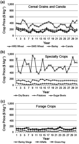
Ten crops were included in the crop rotations of the representative farms. Crop price data for 31 years (1980 to 2010) were used to establish price variations around the historical price trends. These price variations were then used to establish time series data for 31 years of crop prices in constant dollars (Figure ). The price series were repeated to establish a price series for 74 years, the same period as the weather data.
Figure 2 Crop prices in constant dollars for 31 years (1980 to 2010).
Water allocation optimization
Historical water supply and crop price data series were used in the analysis. Annual available water supply and crop prices used within the FFIRM for analysis of each scenario were randomized by varying the starting point in the two data series for 10 model runs. Farm revenue was maximized with respect to irrigation amounts on a field-by-field basis using the water allocation optimizer routine in the FFIRM. For each year of the analysis, the optimization routine allocated the total irrigation water available in each irrigation region among different fields on the representative farms based on the relative value of crops within each farm in order to maximize total farm revenue. Incremental yields for each crop were determined using crop yield-water requirement relationships (Table ).
Financial impact and risk
Net farm income, probability of negative net farm income, farm asset to debt ratio, and farm solvency were the main economic performance indicators evaluated using the FFIRM. A simulation period of 74 years was used for determination of farm financial impacts and risk. The debt level of representative farms was set within the FFIRM at 30% for the initial financial analysis, which is considered a medium level of debt. Subsequently, the model was also run with a “high” initial debt level of 50% to assess the impact on financial solvency.
Water management scenarios
Three scenarios were examined with the FFIRM – a baseline scenario and two irrigation expansion scenarios. The baseline scenario consisted of the 1991 irrigation district expansion limit of 533,785 ha (Irrigation Water Management Study Committee Citation2002) with irrigation infrastructure, crop mix and irrigation system types as they were in 2009. The first expansion scenario included the 2009 irrigation district expansion limit of 558,236 ha, with irrigation infrastructure, crop mix and irrigation system types as they were in 2009. The second expansion scenario was based on a projected irrigation district expansion limit of 604,457 ha, with irrigation infrastructure, crop mix and irrigation system types from 2009. This scenario included projected expansion of about 10,000 ha in the Lethbridge Northern Irrigation District, 4000 ha in the Taber Irrigation District, 16,000 ha in the St. Mary River Irrigation District and 16,000 ha in the Bow River Irrigation District. Irrigation system application efficiencies for each irrigation method (Table ) were used to determine weighted-average application efficiency for each irrigation block based on the mix of irrigation methods. A 90% level of irrigation management (irrigators apply 90% of the optimal amount) was used for analysis of the expansion scenarios, which is an average level of irrigation management achieved with modern, low-pressure centre-pivot irrigation systems (Nitschelm et al. Citation2011).
Results and discussion
Farm gate demand and water supply deficits
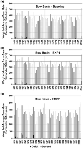
Weighted-average farm gate demand and water supply deficits were extremely variable for the baseline and both expansion scenarios in the Oldman Basin (Figure ) and the Bow Basin (Figure ). The frequency of water supply deficits was somewhat greater in the Oldman Basin than in the Bow Basin and the magnitude of these deficits was slightly greater with increased expansion in the Oldman Basin. Irrigation regions in the Oldman Basin had a water supply deficit greater than 100 mm in only four of 74 years. A water supply deficit greater than 100 mm was never observed in the irrigation regions of the Bow Basin. Individual blocks or irrigation regions in each basin that were used for farm financial analysis had a greater frequency or magnitude of water supply deficits than those depicted for the basins as a whole (data not shown).
Figure 3 Weighted-average farm gate demand or water supply deficits for the baseline, recent (EXP1) and future (EXP2) expansion scenarios in the Oldman River Basin.
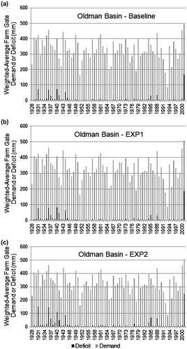
Figure 4 Weighted-average farm gate demand or water supply deficits for the baseline, recent (EXP1) and future (EXP2) expansion scenarios in the Bow River Basin.
Net farm income – baseline scenario
Average annual net farm income (NFI) for the representative farms in the six irrigation regions ranged from $18,843 to $34,919 for the Grain and Oilseed Mix, from $41,317 to $88,552 for the Grain and Forage Mix, from $81,117 to $156,394 for the Forage Mix, from $113,660 to $161,674 for the Sugar Beet Mix and from $269,164 to $294,536 for the Potato Mix (Table ).
Table 7. Changes in average annual net farm income (NFI) with recent irrigation expansion (EXP1) and future irrigation expansion (EXP2) for representative farms in six irrigation regions.
Differences in NFI among the six irrigation regions were attributed to the specific crop mixes in each region (Table ), the associated crop prices and production costs, the irrigation system mix in each region, and variation in evaporative demand and water supplies from year to year that affected crop yield. Average annual NFI for the irrigated area in the 1991 expansion limits based on 2009 conditions was substantially greater than average annual NFI reported for a similar scenario based on 1999 conditions (Heikkila et al. Citation2002).
Net farm income – expansion scenarios
An increase in the irrigation district expansion limits from 1991 to 2009 (EXP1 compared to the baseline) had very little impact on NFI for representative farms in the irrigation regions in the Oldman and Bow River Basins (Table ). Additional increases in irrigation district expansion limits (EXP2 compared to the baseline) would result in a decrease in NFI of 3% or less for representative farms in the irrigation regions in the Oldman River Basin, and would have very little impact on NFI for representative farms in the irrigation regions of the Bow River Basin.
In the Glenwood-Magrath irrigation region, average annual net farm income (NFI) increased by $587 for the Grain and Forage Mix and by $775 for the Forage Mix representative farms for scenario EXP1 compared to the baseline (Table ). A drop in NFI for the representative farms of $1793 for the Grain and Forage Mix and $2783 for the Forage Mix was observed for scenario EXP2 compared to the baseline.
A small decline in NFI (less than $500) was detected in the Lethbridge-Picture Butte irrigation region in all four representative farm types for scenario EXP1 compared to the baseline (Table ). There was a more significant decrease (–$2014 to –$3753) in NFI for all four representative farms with EXP2 compared to the baseline.
For the Taber-Bow Island irrigation region, there was a decrease of $81 in NFI for the Sugar Beet Mix with EXP1 compared to the baseline (Table ). Very small changes in NFI were recorded for the Potato Mix and Forage Mix ($15 and –$8, respectively). Slight decreases in NFI for all representative farms were observed for EXP2 compared to the baseline (–$692 to –$4218).
For the Vauxhall irrigation region, no significant change in NFI was observed with EXP1 compared to the baseline, except for a drop in NFI of $255 for the Sugar Beet Mix and $82 for the Forage Mix representative farms (Table ). A loss in NFI of $857 was recorded for the Sugar Beet Mix and of $406 for the Forage Mix with EXP2 compared to the baseline. These losses are considered negligible relative to the baseline level of income.
In the Strathmore irrigation region, a loss of $139 was detected for the Grain and Forage Mix and of $405 for the Forage Mix farms with EXP1 compared to the baseline scenario (Table ). In the same region, greater losses were recorded with EXP2 compared to the baseline. These losses are also deemed negligible compared to the baseline.
For the Brooks-Gleichen irrigation region, only the Forage Mix recorded any losses (less than $100) for both expansion scenarios compared to the baseline (Table ).
Modeling results indicated that scenario EXP1, an expansion in irrigated area from the 1991 expansion limits to the 2009 expansion limits based on 2009 conditions (irrigation infrastructure, irrigation system mix and efficiencies, crop mix, irrigation management), would have had little impact on farm NFI. Increased water-use efficiencies associated with improvements in water conveyance infrastructure and operations (Figure ), and upgrades of on-farm irrigation systems to more efficient sprinkler irrigation systems (Figure ) have allowed irrigation expansion from the irrigated area in the 1991 expansion limits to the 2009 expansion limits without significant changes in average annual NFI in scenario EXP1.
Figure 5 Types of water conveyance infrastructure in the 13 irrigation districts from 1999 to 2011.
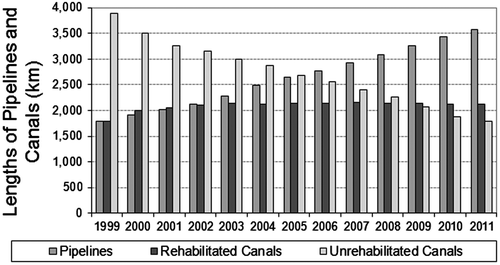
Figure 6 On-farm irrigation methods in the 13 irrigation districts from 1999 to 2011.
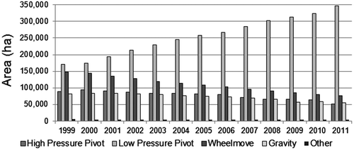
A slightly greater risk of negative NFI was identified with additional expansion in scenario EXP2. Significant water savings are anticipated from rehabilitation of water conveyance infrastructure and upgrades of on-farm irrigation systems in the next decade (AECOM 2009; AMEC Citation2009). Approximately 2100 of the 7620 km of canals in the irrigation districts were rehabilitated from 1999 to 2011, leaving about 1800 km of canals to be rehabilitated (Figure ). On-farm irrigation systems were upgraded to low-pressure centre-pivot systems on almost 177,000 ha in the irrigation districts from 1999 to 2011, with more than 182,000 ha irrigated with high-pressure centre-pivot, side-wheel, and gravity irrigation systems in 2011 (Figure ). The expected gains in irrigation efficiency will likely offset the increased risk of negative impacts on NFI in scenario EXP2.
Probability of negative net farm income
While the average annual NFI is a key economic indicator of the financial well-being or sustainability of the various farm types, the probability of negative NFI was also examined to assess performance trends during the study (Table ).
Table 8. Probability of negative net farm income (NFI) on representative farms in six irrigation regions for baseline, recent irrigation expansion (EXP1), and future irrigation expansion (EXP2) scenarios.
Grain and Oilseed Mix representative farms had the greatest probabilities of negative NFI, due to the generally lower value of the commodities and the significantly greater annual variation in prices (Table ). The greatest probabilities of negative NFI were observed for Grain and Oilseed farms in the Taber-Bow Island and Vauxhall irrigation regions, with no change in probabilities of negative NFI for the two expansion scenarios. The probabilities of negative NFI ranged from 21 to 25% for the baseline, EXP1, and EXP2 scenarios in the Lethbridge-Picture Butte and Brooks-Gleichen regions.
Negative NFI probabilities for Grain and Forage Mix farms ranged from 1 to 9% for the baseline, EXP1, and EXP2 scenarios (Table ). Probabilities of negative NFI for Forage Mix farms ranged from 0 to 1% for the baseline, EXP1, and EXP2 scenarios in all the irrigation regions, except for the EXP2 scenario in the Vauxhall region (5%).
The Sugar Beet Mix farms had no risk of negative NFI in the three scenarios (baseline, EXP1, and EXP2). The Potato Mix farms did not encounter negative NFI for any of the scenarios examined.
Risk of financial insolvency
The FFIRM calculates farm assets and liabilities with time, which was 74 years in this study. When the probability of negative NFI rises, farm assets tend to decline and liabilities rise. In some situations, the balance sheet can become so stressed that the farm becomes insolvent (bankrupt). In this study, the criterion that established farm insolvency was when the debt-to-asset ratio exceeded 0.6 and the “current ratio” was lower than 1.0.
The only farm type to experience farm insolvencies at the 30% level of initial debt was the Grain and Oilseed Mix. This occurred in the Taber-Bow Island region where the probability of insolvency was 10% for the baseline scenario and both expansion scenarios.
At the 50% level of initial debt, the Grain and Oilseed Mix representative farms in the Glenwood-Magrath and Lethbridge-Picture Butte regions became insolvent under the baseline and two expansion scenarios. The irrigation water supply limitations in the different scenarios did not impact the outcome, except to hasten the insolvency by a year or two. In contrast, the Forage Mix and Potato Mix representative farms remained solvent under all three scenarios in all irrigation regions. Therefore, the water supply scenarios did not have an adverse impact on the solvency of these farms.
Conclusions
The farm financial impact and risk of two irrigation expansion scenarios were assessed based on the potential for water supply deficits in the irrigation districts of southern Alberta. The two irrigation expansion scenarios examined would have negligible or very small adverse impacts on the financial well-being of typical farms in all of the regions examined. Representative farms experienced virtually no change in NFI in the simulation of the recent expansion (EXP1) scenario, and very small reductions in NFI in the future expansion (EXP2) scenario. The probability of negative net farm income increased by 1% or 2% for two of 19 representative farms in the EXP2 scenario. The farm financial impact and risk of recent irrigation expansion did not change dramatically from the irrigated area in the 1991 expansion limits to the 2009 expansion limits due to increased water-use efficiencies associated with improvements in water conveyance infrastructure and operations, and upgrades of on-farm irrigation systems to more efficient sprinkler irrigation systems since 1999. Increased commodity prices during the last decade and improved crop varieties and agronomic practices that have enhanced the yield potential of irrigated crops have allowed irrigation expansion without significant changes in NFI. Crop diversification and inclusion of crops with greater value in crop rotations were key factors for increasing farm financial viability and stability. Continued irrigation efficiency gains in the near future would likely offset the increased risk of negative impacts on NFI with irrigation expansion to the current limit of 612,200 ha.
Acknowledgements
Irrigation water demand and supply modeling for this study were performed by Don Roth, Alberta Agriculture and Rural Development, and by Laurent Conard, Alberta Environment and Sustainable Resource Development. Assistance from Bob Winter and Bonnie Hofer in preparation of this manuscript is also gratefully acknowledged.
Notes
Member of CWRA
Related Research Data
References
- Alberta Agriculture and Rural Development. 2012. Alberta Irrigation Information – 2011. Lethbridge, Alberta: Irrigation and Farm Water Division.
- Bennett, D. R., and T. E. Harms. 2011. “Crop Yield and Water Requirement Relationships for Major Irrigated Crops in Southern Alberta.” Canadian Water Resources Journal 36 : 159–170.
- Government of Alberta. 1999. Irrigation Districts Act. Edmonton, Alberta: Queen’s Printer.
- Nitschelm, J., J. Cordes, B. Riewe, and R. Hohm. 2011. Current Irrigation Management Practices Study 2007–2009. Lethbridge, Alberta: Alberta Agriculture and Rural Development.
- Shen, S. S. P., P. Dzikowski, G. Li, and D. Griffith. 2001. “Interpolation of 1961–97 Daily Temperature and Precipitation Data Onto Alberta Polygons of Ecodistrict and Soil Landscapes of Canada.” Journal of Applied Meteorology 40 : 2162–2177.
- Toma and Bouma Management Consultants. 2007. Enhancing Value Added Food and Agriculture on Irrigated Lands. Lethbridge, Alberta: Alberta Agriculture and Rural Development.
- Underwood McLellan Ltd. 1982. Agronomy Component: Irrigation Water Requirement Study. Lethbridge, Alberta: South Saskatchewan River Basin Planning Program.