
Abstract
The interest surrounding groundwater protection in Southern Ontario has grown considerably since the Walkerton tragedy of May 2000. Since that time, a number of technical studies have been undertaken by the Province to support the preparation of Source Water Protection plans. Underlying all sound water resource management initiatives in Ontario is the need for a renewed focus on the fundamentals, specifically in this case a focus on groundwater knowledge and its management. Using the Oak Ridges Moraine Hydrogeology Program as a unique example of a groundwater “knowledge management” system, this paper presents some unexplored opportunities that merit further consideration in the application of a “knowledge management” philosophy within Ontario’s overall water management framework. Within the Program’s study area, the linkage and integration of the Water Well Information System with other borehole datasets and consulting reports, as well as with water use (e.g. municipal pumping) and water quality databases, has created perhaps the most comprehensive, actively managed groundwater “knowledge management” system in Canada. Ongoing Source Water Protection and other work undertaken through consultants, including data and geological/hydrogeological interpretations, is being re-incorporated, where sound and appropriate, into the program’s existing groundwater knowledge infrastructure. The program’s groundwater “knowledge management” system has been developed with a long-term (i.e. multi-decade) water management time frame in mind and is made accessible to geoscientists undertaking work in the area.
L’intérêt entourant la protection des eaux souterraines dans le sud de l’Ontario s’est accru considérablement après la tragédie de Walkerton en mai 2000. Depuis cet événement, le gouvernement provincial a entrepris plusieurs études techniques pour soutenir la préparation de plans de protection des sources d’approvisionnement d’eau potable. Derrière toutes les initiatives visant la gestion rigoureuse des ressources hydriques en Ontario se trouve la nécessité de porter attention renouvelée sur les aspects fondamentaux et, pour ce cas particulier, une attention ciblée sur la connaissance des eaux souterraines et leur gestion. Utilisant le programme de caractérisation hydrologique de la moraine d’Oak Ridge comme exemple unique d’un système de « gestion des connaissances » sur les eaux souterraines, cet article présente quelques opportunités inexplorées qui méritent plus de considération dans l’application d’une philosophie de « gestion des connaissances » dans le cadre global de la gestion de l’eau en Ontario. Dans la zone d’étude du Programme, les liens et l’intégration de l’information sur les puits d’eau potable avec d’autres ensembles de données sur les forages et les rapports de consultants, ainsi que les bases de données sur l’utilisation (ex. : pompage municipal) et la qualité de l’eau, ont créé ce qui est probablement le système de « gestion des connaissances » sur les eaux souterraines activement géré le plus complet du Canada. S’ils sont rigoureux et pertinents, les futures travaux sur la protection continue des sources d’approvisionnement en eau et les études des consultants, y compris les interprétations géologiques et hydrogéologiques, seront intégrés à l’infrastructure existante de connaissances sur les eaux souterraines du programme. Le système de « gestion des connaissances » sur les eaux souterraines a été créé avec une vision à long terme (sur plusieurs décennies) de la gestion de l’eau, et il est disponible aux géoscientifiques qui entreprennent des travaux dans la région.
Introduction
As in many other jurisdictions, in Ontario the complexity of managing groundwater is reflected in the large number of government agencies, at several levels, that contribute regulations, rules, guidelines and general oversight to controlling the various human activities that may affect the groundwater system. At the provincial level, the Ministry of Environment (MOE), Ministry of Natural Resources (MNR) and Ministry of Municipal Affairs and Housing (MMAH) have significant roles in groundwater management and protection, whereas the Ministry of Health (MOH) and the Ministry of Agriculture, Food and Rural Affairs (OMAFRA) also play roles, albeit of a more limited nature. At the local level, largely through the many submitted applications to change land use, additional oversight and implementation of many groundwater management activities are carried out by municipal governments and conservation authorities. On behalf of the federal Department of Fisheries and Oceans, many conservation authorities also screen planning applications for possible harmful alteration, disruption or destruction (HADD) of fish habitat, although recent changes at the federal level may diminish this activity. Effective groundwater management therefore should involve all levels of government and all departments within an organization that is involved in land use, resource use and servicing/infrastructure.
Looking back historically, it is noteworthy that during the establishment of the Ontario Water Resources Commission (OWRC) in the mid 1950s, which incidentally preceded, and then, in 1972, evolved into, the current Ministry of Environment (MOE), it was deemed important that the responsibility for the assessment and management of Ontario’s water resources lie under a single umbrella group (Scott Citation1970). Coincidentally, during the 1950s, the United States Geological Survey had similar concerns regarding the fragmentation of water resource management, which led to the restructuring and integration of its then-separate water resource program branches under the direction of Luna Leopold (Hunt and Meine Citation2012). Between its inception in 1956 and its final integration into the MOE, the staff at the OWRC gained wide-ranging respect for their scientifically principled knowledge and management of Ontario’s groundwater resources and for their informative scientific reporting.
Following the May 2000 tragedy in Walkerton where seven people died after consuming E. coli-contaminated municipal groundwater, the provincial government has embarked on a long-running and continuing journey to ensure safe drinking water for Ontarians. One of the pillars of this work, Source Water Protection (SWP), was brought forward under the 2006 Clean Water Act. Through this Act, Ontario required that SWP committees be struck and charged with preparing SWP plans to protect existing and future sources of drinking water across the Province. Based on science, the plans are developed locally and collaboratively with the goal of enacting policies to manage land-use activities in the areas around municipal wells or surface water intakes.
Since the direction from Justice O’Connor (Citation2002) was to undertake the work on a watershed basis, Ontario’s conservation authorities, working in partnership with municipalities, were charged with leading the technical work which has led to the preparation of watershed-based “Assessment Reports”. These technical reports characterize the existing hydrological/hydrogeological conditions within Ontario’s watersheds and include an inventory of authorized water takings as well as land uses or activities that may impact on the quality or quantity of water supplies. A significant component of the Assessment Reports is the undertaking of a water budget analysis. The technical Assessment Reports form the basis for the subsequent Source Protection Plans (SPP) being prepared by and for each Source Protection Area. The Source Protection Areas conform to existing conservation authority boundaries.
With all of this new SWP work now having been undertaken, it is important that this significant Provincial investment continue to be effectively used and built upon going forward. The data, knowledge and understanding that have been gained through SWP are in danger of winding up on the shelves if a concerted effort in knowledge management is not undertaken. Has the overall technical knowledge gained through SWP been adequately transferred to the public? Are the data collected housed effectively and are they readily accessible to other practitioners?
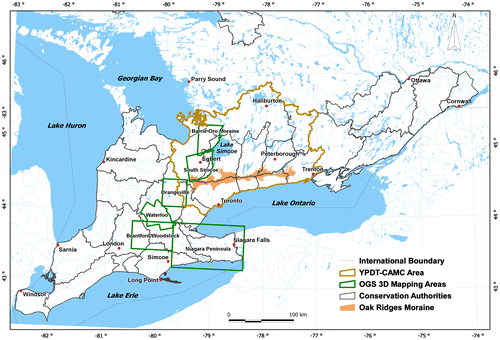
The objective of this paper is to explore and comment on aspects of groundwater knowledge management that could be implemented in Ontario. The suggestion is that through multi-agency cooperative efforts, as evidenced by the Oak Ridges Moraine Hydrogeology Program (York, Peel Durham Toronto [YPDT]-Conservation Authorities Moraine Coalition [CAMC]), groundwater-related data are more thoroughly and carefully collected, analysed and managed. By extension, groundwater flow systems, including links to the surface, and the associated implications to planning and municipal servicing, are more accurately characterized and understood, thereby leading to more sound water management decisions and policy. The study area for the Oak Ridges Moraine Hydrogeology Program (herein referred to as the ORM Program) is shown in Figure .
Figure 1. Oak Ridges Moraine Hydrogeology Program (YPDT-CAMC) study area (York, Peel Durham Toronto [YPDT]-Conservation Authorities Moraine Coalition [CAMC]). The small rectangular box in the center of the study area shows the map area for Figure 2.
![Figure 1. Oak Ridges Moraine Hydrogeology Program (YPDT-CAMC) study area (York, Peel Durham Toronto [YPDT]-Conservation Authorities Moraine Coalition [CAMC]). The small rectangular box in the center of the study area shows the map area for Figure 2.](/cms/asset/4bed8df0-bf9d-4c53-bd7a-328353b39d1e/tcwr_a_914788_f0001_oc.gif)
Groundwater knowledge management
There shall be no man or woman dare to wash any unclean linen, wash clothes, ... nor rinse or make clean any kettle, pot, or pan or any suchlike vessel within twenty feet of the old well or new pump. Nor shall anyone aforesaid, within less than a quarter mile of the fort, dare to do the necessities of nature, since by these unmanly, slothful, and loathsome immodesties, the whole fort may be choked and poisoned. (Gates, Citation1610)
This quotation, now some 400 years old, and clearly a very early example of Source Water Protection, speaks to the groundwater knowledge of the time. It was suspected that the migration or transfer of pollutants into a well or water supply could take place from adjacent areas. Over the years, this initial rudimentary understanding has grown such that the technical details of contaminant transport through the subsurface are now reasonably known. This example of knowledge capture and transfer provides a context for the following discussion.
In the past 10 to 20 years, both public-sector agencies and private corporations have come to recognize the importance of the need to better manage information. In the seminal 2001 report entitled Managing the Environment, Gibbons notes that the Ministry of Environment was lacking in a strategy “to create, manage and use external and internal knowledge” (Gibbons Citation2001). In arriving at this conclusion, they note the erosion of historical links between the academic community in Ontario’s universities and the MOE, as well as the societal trend towards devaluing the legitimate role of public service to build a strong knowledge-creation and analysis capacity. The development of a comprehensive Environmental Knowledge Management strategy is one of 10 key recommendations arising from the report. “Knowledge Management” has evolved as a discipline on its own and there have been many theoretical management papers written on the topic (e.g. Brown and Duguid Citation1998; Karreman Citation2001). For the purposes of this paper, the term has come to mind owing to several observations of similar hydrogeological investigative work being undertaken at the same location, often separated in time by up to several decades. Also of note is the departure due to retirement of many experienced practitioners who take with them many years of knowledge regarding Ontario’s groundwater and surface water resources.
In the context of the discipline of knowledge management, knowledge is not data, nor is it information. Rather, it is what is known. Ideally, a knowledge management system would be able to capture lessons, strategies, stories, guidelines, etc. (Durrant Citation2001). In the case of a resource that is as disparately managed as groundwater, decision-making would benefit from a system that would capture and organize the collective memory of the many individuals and organizations, both public and private, which have played and continue to play roles in the management of Ontario’s water resources. As such, knowledge management in the context of the following discussion is most pointedly applied to the capture of organizational memory. Effectively harnessing this groundwater memory would improve groundwater decision-making by enabling users to locate the focused information they need, when they need it, so they can apply it to their work readily without having to comb through irrelevant information.
With the increasing attention on water resources in Ontario since the Walkerton tragedy, and as demand for water increases simultaneously with the uncertainty associated with climate change, it is becoming critical that groundwater practitioners in the Province “know what we know” with respect to our water resources and that they are able to readily access and make use of this knowledge. Budgetary restraints are also an important driving factor to make better use of previously gained knowledge. Water resource knowledge resides in many places at all three levels of government (federal; provincial; municipal and conservation authority) as well as within the private sector. Knowledge can be found in corporate and individual databases, filing cabinets, reports, people’s heads, etc. Remaining unaware of what we collectively know leads to duplication, re-invention and waste (Australian Local Government Association [ALGA] Citation2004).
It is our experience that some groundwater-related work is being repeated, sometimes after several decades, simply because there has not been careful tracking of experiences and lessons learned. For example, the drilling of municipal exploration wells has taken place in the same location, separated in time by decades and, not surprisingly, with the same results and conclusions. Also, poor decisions have been made as a result of a limited understanding of the groundwater flow system that has been documented in previous, difficult-to-access reports.
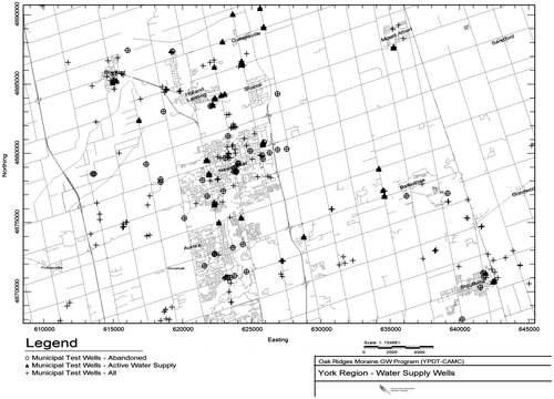
Figure provides a very simple example of how the use of previously acquired information could be harnessed to improve groundwater decisions. The figure shows a plot of wells in the MOE’s Water Well Information System (WWIS) that were drilled within a part of York Region for municipal exploration or supply purposes. The black “plus” sign locations show all of the municipal test wells drilled over the years, and the black triangles show those wells, a small percentage, that have been successfully completed as high-capacity municipal supply wells. On the other hand, the circles indicate wells that have been reportedly abandoned immediately after drilling owing to insufficient aquifer yields. The wells that are neither triangles nor circles have generally been converted to monitoring wells of one kind or another. It can be seen that there are several cases where more than one unsuccessful well (circles or plus signs) has been drilled at the same location, this often occurring over a time span of several decades. Certainly in planning new municipal groundwater exploration programs, such a map, when combined with additional geological knowledge and insights, would prove indispensable in providing clues as to where one might explore in the search for new supplies. Surprisingly, with staff turnover both in the private sector as well as in the municipal sector, historical information of the nature shown in Figure is less frequently utilized than one would expect.
Figure 2. Portion of York Region showing municipal water exploration and supply wells.
Although the above example is more directly linked to data within a database versus derived or interpreted knowledge, other less direct examples can be readily found. How should it be remembered that there are very significant flowing conditions in High Park in Toronto, along Major Mackenzie Drive in Richmond Hill, or along Horseshoe Valley Road near Barrie? Who should remember that the Thorncliffe Formation contains a very productive coarse-grained gravel channel at the location of the recently excavated sewer dewatering shaft along 16th Avenue in Markham? Who should recall the locations of springs and former streams in the City of Toronto that may significantly affect current construction costs? How are the locations of known trout spawning beds (groundwater discharge areas) incorporated into groundwater decision-making?
Unquestionably, there is great economic value in the subsurface information that can be gleaned from historical works. Considering the great expense of drilling new wells, especially if they are unsuccessful, or the expense of failed construction projects, for example, as a result of unknown flowing conditions, combined with the desire to effectively manage water resources for overall societal good, it certainly seems warranted that “out of sight” groundwater-based knowledge management be given a higher priority.
A key “knowledge management” plank in the efforts of the ORM Program is to make available previously written reports and papers that are relevant to the groundwater resources of the study area. Key reports have been scanned and catalogued into a digital library and assigned coordinates so that they can be quickly located on a map. The reports are searchable within the database on any number of key fields (e.g. author, author agency, client, title, year, key words, etc.). The digital report library has already proven to be of significant importance in capturing and organizing groundwater knowledge so that it can be readily brought to bear on current groundwater concerns.
To further house and document some of these key interpreted aspects of Ontario’s groundwater knowledge, the ORM Program is also developing a geographically based database table/geographic information system (GIS) layer that would bring to the attention of Ontario’s groundwater practitioners some of the key groundwater insights learned over the past decades. Categories of “knowledge management” locations would include those related to construction, flowing conditions, environmental linkages, geological anomalies, etc. For each record, the database houses the category, the consultant or hydrogeologist involved in the project, a start and end date, and a memo field documenting the key insight linked to the location. The groundwater knowledge management table will be slowly populated over the coming years as different consultants are interviewed to capture insights gained from their experiences.
Groundwater knowledge management through Source Water Protection
Within this context, it is worthwhile to examine the recent roll-out of Ontario’s SWP work. Over the past few years, the Province has allocated some $150 million through Conservation Ontario to the conservation authorities (CAs) for SWP initiatives. The funding has been used to cover some CA staff costs, with the remainder directed to the consulting community to complete various tasks required under the SWP program. Although many of the SWP tasks that have been undertaken have been fairly typical consultant contracts (e.g. watershed characterization reports, assessment of properties for risk management, etc.) it is the groundwater modelling work that merits further discussion here.
The precise funds that have been allocated to SWP groundwater modelling across the province have not been specifically tracked. However, it is estimated that they are on the order of tens of millions of dollars, perhaps as high as $50 million. While this is not a particularly large number in the context of provincial spending, it is certainly large when it comes to the capacity of Ontario’s groundwater consulting community to carry out groundwater modelling initiatives, particularly recognizing that these funds were allocated over a fairly short time span (roughly between 2007 and 2011). It is put forward here that groundwater modelling creates unique opportunities to gain insight into groundwater flow systems and that all of the insights gained are typically not well documented or captured in the consulting reports returned to the public sector.
Groundwater modelling investigations typically consist of two distinct phases, the first being the model construction, development and calibration phase. The second phase typically involves running the calibrated model under several scenarios, generally to evaluate wellhead protection areas and assess their potential variability as a result of changing pumping or land use. Both phases are typically carried out by the consulting community. However, it is only later in the second work phase where there may be public-sector staff input and engagement in the modelling process. Following the required SWP analyses, the models are then to be transferred to the conservation authority or municipality so that they are available to run indefinitely to assist in decision-making.
There is little discussion in the literature regarding whether the insights and knowledge of the geological framework and the groundwater flow system garnered through modelling studies are greater through the first or the second phase of modelling work; in other words, “Is the journey more important than the destination?” It is put forward here that with respect to groundwater modelling, and depending upon the complexity of the system being modelled, the journey can indeed be significantly more important than the destination. Greater insights into the groundwater system are frequently gained in the building phase of modelling work. It is during this period that the conceptual model is developed and initially tested, and it is in this phase where the input parameters are assigned and adjusted to investigate how the flow system responds to subtle changes. During this stage of development work, changes can be significant, for example those made to the overall conceptual model, or they may be more typical and include adjustments to input parameters such as recharge, boundary conditions, porosity or hydraulic conductivity. Frequently, small but very salient details or nuances are uncovered during the model-building phase of work, and these can be important to the longer-term understanding of the groundwater flow system and management of the resource.
From our experience, modellers focus on running and re-running the model as they continually adjust and tweak model parameters. It is perhaps a distraction and an inconvenience to stop the modelling process and adequately transcribe many of the key insights into the groundwater flow system that are learned during this work. This groundwater knowledge is frequently absent from the final reports, and with the minimal public sector staff engagement during this early phase of work, at the end of the project, these key insights are only retained by the consultant or, more typically, they are lost and forgotten as they move to new projects.
Within the ORM Program, it has been proposed that groundwater flow models would be managed as “living” entities under the concept that the models would be continually updated and improved as new data are collected and new insights or knowledge are gained. It has also been proposed that the updating process would be overseen by public-sector agencies with technical support from consultants as required. This overall model management direction, and in particular the concept that the models will be improved over time by differing consultants, is uncommon. More typical is the case where a groundwater model is prepared to address only a particular issue and is then abandoned once the goal is accomplished.
As this ORM Program-proposed path of maintaining “living”, continually improved groundwater flow models is carried forward and perhaps adopted elsewhere, it is worth considering how the groundwater insights, the groundwater “knowledge” from these modelling studies, and in particular from the early phases of work, can be brought forward and beneficially “managed”. The “living model” concept has met with mixed results in the ORM Program, in part due to the flood of SWP money over a short time frame which enabled the creation of many localized groundwater flow models. The process of checking these models and re-incorporating the insights gained into a more regional unified interpretation is time consuming and much work remains to be undertaken in this regard. Outside of the ORM Program study area, the future use of the constructed groundwater flow models is uncertain, given the lack of financial resources available to retain consultants to re-run the models for particular tasks. It is put forward that the path of future groundwater model use and additional development within Ontario needs to be re-examined within the context of longer-term water resource management.
With this brief discussion on where SWP initiatives might be better integrated into a broader knowledge management system, it begs further questioning as to whether other aspects of Ontario’s groundwater management could also be improved. Given that the initial phase of SWP technical groundwater work that has been undertaken across Ontario since 2006 is now nearing completion, it is indeed timely to ask such a question. These possibilities are explored further in the next section.
Managing Ontario’s groundwater related data
To effectively understand, regulate and manage Ontario’s groundwater resource, a solid understanding of how water moves through our watersheds is needed, which in turn requires ready access to well organized, high-quality data and information. The prime data source that is utilized in all of Ontario groundwater studies is the WWIS, managed by the MOE. The Province, through what was then the Geological Branch of the Department of Mines, first licensed well drillers in 1946 and they began to collect information on water wells at this time; licensing continues to this day. Within the Ministry, the data have been stored in various formats, and over the years, external access to the WWIS has been provided through various methods. In earlier years, the Ministry (or its OWRC predecessor) offered hard-copy reports of the well records through periodically published Ground Water Bulletins. When that became too unwieldy or expensive, access to the database became more difficult in the 1980s and 1990s. In the early days of computers, throughout the 1980s, the WWIS data were only available in hard copy on a county-by-county basis, by request. In the 1990s, as digital data and computing became more widespread, the Ministry experimented with a fee to access the WWIS data. Recently, with renewed leadership within the MOE’s Environmental Monitoring and Reporting Branch (EMRB), online access to individual well records was granted, and currently, county/region-wide digital data are directly downloadable from the MOE (MOE Citation2014).
A second important groundwater-related database that is administered by the MOE stores the Permit To Take Water (PTTW) program data. Beginning in 1961, legislation required that all water taking in excess of 50,000 L/day have a permit issued by the MOE. In more recent years, a significant improvement to the management of this dataset has seen the MOE move to collect records of actual volumes of water taken from PTTW sources.
The WWIS houses basic information on wells drilled in the province. The database contains details pertaining to the following aspects of each well at the time of original construction or upon a significant alteration:
location (e.g. map and coordinates, elevation);
construction (e.g. screen depth, diameter, casing type, seals, etc.);
hydrogeology (e.g. static and pumping water levels, depth at which water was found, test pumping rate and recommended pumping rate);
purpose, and
geology (the depth and thickness of each layer intersected in drilling the well).
Slight changes to the information collected have been made over the years; however, the core set of information captured has largely remained consistent. One significant adjustment to the WWIS system began in 2003 with an updated well regulation that clarified the requirement for non-water supply drillers to submit well records for test holes or dewatering wells. Formerly, only water supply well drillers routinely submitted well records to the MOE, and many of the higher-quality boreholes from a geological logging perspective were never captured into the WWIS. Since 2003, some wells drilled for geothermal energy purposes remain outside of the regulation requiring records to be submitted to the MOE.
Given the far-sightedness of the early MOE pioneers in developing a database system to capture and store well record information, it is discouraging to note that, aside from the 2003 change, there have been very few innovative ideas reflected in the formal capture of Ontario’s groundwater information. The Clean Water Act and its SWP initiatives provide an opportunity, albeit one that is rapidly fading as the Province moves on to other priorities, for the MOE to rethink its data management practices.
Database opportunities
Since 2001, the ORM Program has been actively building a groundwater database system that significantly expands upon the information housed in the WWIS (Holysh et al. Citation2011). With reasonable expenditures in terms of staff time, energy and money, the MOE could make similar efforts that, over time, would incrementally enhance the scope and quality of information made available to Ontario’s groundwater practitioners. It is suggested that if the opportunities presented below are acted upon, water resource management across Ontario will be markedly improved. It is also worth noting that most Canadian provinces collect and organize groundwater information in a similar fashion to Ontario (Council of Canadian Academies Citation2009), and therefore they could also benefit from the discussion presented here.
There are several areas where the WWIS can be readily improved. Suggestions proposed below do not require a significant shift in resources. Indeed, much of what has been accomplished through the ORM Program has been done incrementally with limited resources over a 10-year time frame. Perhaps the key requirements are passion and leadership as well as commitment from many MOE staff, ministry-wide, to improve upon the overall data management at the Ministry. There are six areas outlined below where opportunities exist to improve the WWIS:
General database management,
Additional information,
Screened intervals,
Geological unit assignment,
Incorporation of temporal data, and
Integration of differing datasets.
General database management
The WWIS system is largely overseen by a few individuals and, as a result, it is difficult for MOE staff to ensure that the data reported by well drillers are complete and accurate, and that the data entered into the Province’s digital database are entered correctly. A responsibility that comes with managing the WWIS is that of tracking changes and updates to the WWIS. For many years, the MOE was ill equipped to receive changes (e.g. typos, incorrect interpretation of hard-copy well records, etc.) noted by consultants and others as they used the WWIS in their day-to-day work. As a result, there was an era during the 1990s when opportunities to work with stakeholders to improve upon the database were lost. The MOE has moved forward from this time and staff now update and fix inaccuracies in the WWIS as they are detected. A concern is that, should the database be corrected or changed in any way, under current practices there is no record or flag provided to users indicating a change made within the database. Furthermore, there is no tracking of database versions or date stamps provided with WWIS datasets downloaded from the MOE website. This could have implications for long-standing programs (i.e. PTTW projects, landfill projects, etc.) where consultants or others may have made hydrogeological interpretations based on an older dataset previously provided by the MOE. An improved methodology for tracking changes and updates to the database would be beneficial.
The official well record form that well drillers use to provide information to the MOE has changed many times over the years, yet it has generally required the submission of much of the same information. In 2003, however, a change to the well record form initially required drillers to report all measurements in metric units. Subsequently, with input from drillers, the form was adjusted to allow for the reporting of drilling/construction depths in either feet or metres (as indicated by a checkmark on the correct units). With these changes there arose the opportunity for incorrect units to be applied against geological unit depths and well depths. Errors related to units (metres vs feet) remain in the WWIS and can be significant. Recent discussions with MOE staff suggest that this problem was more significant in the early days of the well record form change-over and has diminished considerably in recent years. The restricting of the reporting again to only one unit of measurement is recommended here to eliminate this confusion, although it is recognized that another change might again introduce a period of error introduction and this must be weighed in any decision going forward.
A further issue is the removal of the well owner from the MOE database owing to privacy concerns. With no access to the original well record submission form, it is difficult in many instances to uniquely identify any particular well. For key public sector or other corporate wells, where construction is overseen by a professional consultant, a borehole record is provided to the client independent of the well driller. In the many cases where the A-tag number is not recorded on the consultant borehole record, and where the coordinates of the two submitted records differ, trying to match the MOE WWIS record with the consultant-produced well record (which often contains enhanced details not included in what the driller reports to the MOE) is often difficult. One suggestion that might assist in this regard is to provide a field for a “Well Name” on the WWIS form (e.g. TW #1-13, Alton OW #3, Angus Glen Golf Course #4, etc.). This would allow for the privacy issue concern of the MOE to be respected, while at the same time helping consultants and others to more effectively find wells in the database. It is noted that access to the original well record form via the internet is currently being planned by the MOE. It is recognized that this may also help to resolve the issue.
Additional information
Subsequent to the amendments to the well regulation (Regulation 903) in 2003, there was an increase in well record submissions to the WWIS as records for various geotechnical test holes and dewatering wells began to be submitted to the MOE. However, prior to this time, many of the better-quality boreholes (e.g. those geologically logged and overseen by consulting hydrogeologists) were not submitted to the MOE for incorporation into the WWIS. Well records for many of these high-quality wells can be found as appendices to consulting reports. In an “opportunistic” fashion (i.e. by only addressing wells that come before MOE staff in the course of everyday work), MOE staff can slowly build into the WWIS some of the key boreholes (e.g. deep wells, flowing wells, etc.) that are absent from the WWIS.
Another possible opportunity would be to link the well records with key scanned or digital PDF reports submitted to the Province in support of various land use planning/water-taking initiatives. With a long-term vision of providing groundwater practitioners with access to publicly available, historical technical groundwater reports in a PDF format, the MOE could drastically reduce the amount of internal and external consulting time, and therefore costs, allocated to searching for background hydrogeological information across the province.
Screened intervals
From both a geological and a hydrogeological perspective, the position and length of the screened interval in the subsurface is critical information. Knowing which aquifer produces the groundwater extracted from a well has implications for all hydrogeological studies. A long-standing WWIS issue is that it fails to identify or link any particular well with a known aquifer or geological unit. Although the WWIS was never intended to incorporate this interpretive information, the ability to place well construction information into a regional hydrogeologic context would be a significant enhancement. This was highlighted most recently as SWP Assessment Reports were being prepared where there was a critical need to identify all wells that were tapping into a specific aquifer unit for the purposes of assessing aquifer hydrodynamics and vulnerability. Also, in those areas where groundwater modelling (e.g. Tier 2 and 3 studies) for the purpose of detailed water budget analyses has taken place, the calibration of the groundwater flow models depends on the assignment of wells to specific hydrogeological units. This information is currently unavailable through the WWIS. There are two reasons for this: (1) the lack of rigorously documented screen information within the WWIS and (2) the lack of a regional geological model to which can be linked the wells and their screens.
The WWIS database provides the depth of the well and, when reported, also stores the top and bottom depths of the well screen. Of concern is the infrequency with which drillers report well screen details to the Ministry. Overall, within the WWIS, only about 20% of wells have a reported screen. The numbers improve somewhat if the bedrock wells are considered separately from wells that terminate above the bedrock in the glacial sediments (i.e. for the wells that are completed within the glacial sediment, 41% have reported screens). Historically, some domestic wells installed within sediments situated above bedrock were completed without any well screens, or rather just as an open pipe or slotted pipe. This information is not included in the WWIS system.
For the wells with no reported screen, assumptions have to be made in order to make good use of the water level data. For wells that advance into bedrock, an assumption has to be made that the well is open along the entire length of bedrock (i.e. “screened”) from the bedrock surface (or from the bottom of a bedrock-seated casing, if reported) to the bottom of the well. For wells that terminate within the glacial sediment, it is uncertain as to whether the wells simply have no screen (i.e., the well is developed using air to leave a coarser-grained sediment in the bottom of the well) or whether the driller failed to report the screen. For these wells, any recorded water level data either have to be omitted from analyses, or the well has to be manually assigned a screen top and bottom. In the case of the ORM Program, these wells have been assigned an assumed screen of 0.3 m length at the bottom of the well. These assumed screens have been flagged in the database to caution any interpretive efforts based on data from these locations.
This lack of screen reporting may be readily solved by introducing a checkbox on the Well Record Form to indicate whether the well has, or does not have, a screen. The new checkbox would allow for a record within the database of those wells that have been purposefully constructed with no screen.
Complicating this situation is the fact that many drillers use the term “open hole” to identify the annular space around the well screen in many non-bedrock wells. This confusion could be removed by educating drillers (perhaps in the MOE’s existing best management practices [BMP] manual; MOE Citation2009) to restrict the use of the term “open hole” to bedrock wells only.
Geological unit assignment
The second part of the problem of identifying aquifers from which individual wells draw their water relates to the absence of a geological/hydrogeological framework into which wells can be positioned. On a well-by-well basis, the WWIS provides documentation of individual geological layers encountered as wells are being drilled. However, it falls short in terms of moving forward to interpret individual layers as part of a recognized hydrogeological formation or unit that can guide future geoscientists.
In the late 1970s, the MOE completed some major aquifer mapping based on information contained within the WWIS (e.g. Turner Citation1977), but these maps have become outdated. Some three-dimensional hydrogeological mapping on a watershed basis was conducted by the MOE during the 1970s and 1980s during the completion of the Water Resources Reports series (e.g. Sibul et al. Citation1977). Singer et al. (Citation2003) also provided a general description of the hydrogeology of southern Ontario. A common theme relating to these earlier initiatives is that they were treated as individual projects rather than as part of a long-term, comprehensive program of quantifying Ontario’s groundwater resources. Over recent years, and certainly with the onset of the Province’s SWP initiatives, there is a growing need to establish common geological frameworks, particularly in areas of thicker glacial sediment packages where no formal provincial geological framework exists. The Geological Survey of Canada initiated such a framework over much of south-central Ontario (e.g. Sharpe et al. Citation2011). Through SWP, the Province has received digital geological interpretations across many parts of the province. These interpretations generally conform to conservation authority boundaries (Figure ). This offers, for the first time, a set of digital layers against which the tops and bottoms of screened intervals can be measured, thus allowing each well screen to be assigned to a geological unit. In areas of overlapping coverage, these SWP geological interpretations could be integrated into the three-dimensional aquifer mapping studies (also shown on Figure ) now being conducted by the Ontario Geological Survey (OGS) (e.g. Bajc and Shirota Citation2007; Brunton and Brintnell Citation2011) to provide updated and authoritative geological mapping across widespread parts of the province. Moving forward, this combined interpretation could then be tested and refined by the OGS as they expand their aquifer mapping program to other parts of the province, and could be used to gain improved understanding of the subsurface environment. It should also be noted that the OGS Ambient Groundwater Geochemistry Program is being conducted in concert with their three-dimensional aquifer mapping program to provide vital documentation of regional groundwater geochemical conditions for Ontario (e.g. Hamilton et al. Citation2011).
Figure 3. Areas within southern Ontario with some level of three-dimensional geological/hydrogeological interpretation.
The geological sediments encountered while drilling through formally recognized geological formations can then be analysed on a formation-by-formation basis to look at the variability of subsurface units that control groundwater movement. In addition, by assigning well screens to individual geological units, the hydraulics of these units can be evaluated to answer many questions that are currently unanswered for many parts of the province (e.g. How much water is being pumped from the Thorncliffe Formation? Is the water quality in the deeper Catfish Creek till different from the shallow aquifer above? What do measurements of the hydraulic head in the Scarborough Formation indicate about the flow system? etc.). Answering these types of questions enhances the quality of submitted reports and the ability of regulators to address cumulative impact concerns.
Currently, within the ORM Program database, there is one dedicated table that houses the results of such a well screen evaluation. For each well screen in the database, the position of the screen top and bottom has been evaluated against different geological models (i.e. the 2003 Core model, the 2007 Durham model, etc.) and assigned accordingly to a widely recognized, interpreted formation. It is recommended that the WWIS be similarly expanded to house at least one field (if not one table) where the “assigned” formation for each screen can be stored. It is not recommended here that the well drillers become familiar with the geological framework to such an extent that they could assign any completed well to a formation or aquifer. The lack of consistency with such an approach would be detrimental to assembling authoritative well screen assignments. Rather, it is proposed that well screen depths be consistently and properly recorded in the WWIS database, and that the “screen/aquifer” or “screen/formation” match-ups be undertaken through a three-dimensional GIS procedure conducted by qualified practitioners as is the case with the ORM Program database.
Incorporation and integration of temporal data
One important area where the WWIS database could be improved is in its capacity to capture and store long-term groundwater-related measurements. The WWIS database has been designed to store the few water level measurements collected at each well during initial testing. However, longer-term pumping rates, chemistry data and additional water level data have no home within the WWIS. It is also surprising to find that other important datasets maintained by MOE staff, such as the Drinking Water Surveillance Program (DWSP) chemistry data, the Provincial Groundwater Monitoring Network (PGMN) data and the PTTW records have not been linked to individual well records. Rather, they are held separately and unlinked to the WWIS. Such a link would be advantageous to the disparate databases, allowing for an integrated analysis of all data from various programs, and perhaps ultimately from different scientific disciplines which often have a need for common baseline information. An example is the need for the chemistry data to be interpreted by well depth or on an aquifer basis, acknowledging the need for strict quality assurance/quality control (QA/QC) protocols relating to water quality data. It is reiterated that effective groundwater resource management requires access to the historical measurements spanning multiple disciplines. This was the premise invoked by the former OWRC (Scott Citation1970). Water quality or water level trends, when measured over long time periods, greatly enhance the understanding of groundwater systems (e.g. how the system might respond to climate change, droughts and wet conditions, how land uses might affect quality, etc.).
As a template, the ORM Program database has been established to store temporal data that are tied back to a particular screened interval in a well. Within this database, three tables house the temporal information and two tables are linked to data that are provided via a laboratory, whereas the third table houses data that are measured in the field. By consolidating the temporal information in such a manner, data of various types can all be stored with a similar format. A “Reading Name Code” points to specific diverse parameters, ranging from climate-related codes (e.g. precipitation, temperature, etc.) to water quality-related codes (e.g. chloride, pH, trichloroethylene, etc.) to hydraulic-related parameters (e.g. water level, pumping rate, streamflow, etc.). Such a transformation in the WWIS would greatly enhance its value to all Ontario government ministries as well as to outside practitioners, and would help it evolve to become a more comprehensive groundwater management database.
Thoughts on future groundwater use
There has been a long-term shift in the more rural communities surrounding Toronto towards Lake Ontario-based municipal water supplies to replace groundwater-based supplies. The list of communities that were once groundwater-based but that now look to Lake Ontario for a water supply is lengthy, and it continues to grow (e.g. Bolton, Bowmanville, King City, Richmond Hill, Oak Ridges, Huttonville, Brampton, Markham, Unionville, Maple, Stouffville [partial], Aurora [partial], Milton [partial], etc.). Kleinburg, the latest in this long list, has just recently turned to Lake Ontario-based water in 2013. For communities further away from one of the Great Lakes, this trend might not yet be manifest owing to the greater expense associated with pipeline construction.
The decision to switch water supply sources is subject to the Class Environmental Assessment (Class EA) process whereby municipalities must succinctly present the problem to be resolved, identify reasonable alternative solutions to the problem, select a preferred solution, file a Notice of Completion and finally implement the preferred solution. Public consultation throughout the process is required. Through the Class EA process, typically the main reasons highlighted for a change-over to Lake Ontario-based servicing are additional growth and the inability for groundwater pumping to keep up with the growing water demand. Other reasons cited for moving away from groundwater include cost and uncertainty tied to exploration, quality and cost of treatment issues (e.g. generally elevated iron, hardness or manganese), uncertainty in the future groundwater supply quantity and/or quality, and maintenance of groundwater-related infrastructure (e.g. well screens and pumps) (see Halton Regional Municipality Citation2007 or KMK Consultants Ltd. Citation2007, for example).
Currently, in those cases where a Lake Ontario source is a viable alternative to groundwater, it is likely that the odds are tipped in favour of a Lake Ontario-based source. Factors that weigh against a groundwater option include:
The uncertainties tied to groundwater exploration and development (i.e. Will the necessary quantity be found? How much effort will be needed to show no negative impact on adjacent users and ecosystems? Will a treatment facility to remove iron or manganese be needed? Will the MOE issue a permit? etc.);
The short time frames generally available to find viable groundwater sources within the Class EA process, and
The lower perceived project “status” tied to groundwater-based options within the municipal arena, taking into consideration aspects such as lower project budgets, lower “press” coverage and lower job creation both internal and external to the municipality.
With the introduction of SWP into the overall mix, in addition to the above considerations, municipalities must now bring any new municipal wells into the SWP plan. This involves, among other challenges:
Initially negotiating with local neighbours of the proposed wellhead for access to drill test wells;
Fighting local opposition to proposed municipal wells due to the perception among rural land owners that SWP will “sterilize” their lands;
Updating groundwater flow models to delineate the wellhead protection areas (WHPAs) (which, incidentally, depending on the new well location, might affect existing capture zones and therefore create additional work to ensure compliance with the SWP plan under the new pumping conditions);
Undertaking risk-based assessments for the land parcels within the delineated capture zones;
Initiating communication and carrying out the necessary SWP plan policies related to affected landowners within the new WHPA, and
Other works required to ensure the long-term protection of the source.
Given all of the above considerations, when a groundwater-based alternative is weighed against the option of building a single pipeline connection to the nearest Lake Ontario-serviced community, the lake-based option often presents as the more favourable alternative, even though the financial costs may be lower for a groundwater-based option. It will be interesting to see if the rate at which communities move away from groundwater increases as the additional costs of SWP become entrenched within the overall municipal workload.
To help counter this trend, a better characterization of groundwater systems would provide water managers with a sound understanding of the capacity of their water source and a more reliable basis for decision-making. Information that is required on a regional basis includes:
The quantities of groundwater potentially available for extraction (i.e. water budgets),
The directions of groundwater flow,
The location and depths of more permeable sediments (i.e. detailed aquifer mapping), and
The interaction with surface waters, particularly where significant groundwater discharge to streams occurs.
Improved characterization of the groundwater flow system is indeed a vision of the ORM Program to assist with adding needed certainty to groundwater-based options when evaluated within the Class EA process. The Region of Waterloo is an example where the groundwater system has been reasonably well explored and characterized. Here too, a Lake option exists, and indeed the Region’s original (2000) long-term water supply strategy envisioned a Lake Erie pipeline by 2035 to deal with the anticipated growth. However, the development of new groundwater sources in the Waterloo Moraine, in combination with water efficiency measures to lower demand, has proven to be a more cost-effective alternative. Water managers now consider the groundwater-based supply to be secure for the foreseeable future.
Concluding remarks
Historically, Ontario has gone through phases – such as during the early Ontario Water Resources Commission days in the 1950s and 1960s, or during more recent post-Walkerton times in the 2000s – when water management was a focused priority for the Province. The 1980s and 1990s reflected a period of less focus on the Province’s water resources. Over this entire period, Ontario has been fortunate to have many high-quality practitioners, within the public sector, in the consulting community and in Ontario’s universities, who have contributed greatly to the understanding and management of Ontario’s water. Fortunately, this continues to be the case.
For an extended period of Ontario’s water resource development history, mostly in the earlier years, the responsibility for collecting groundwater data and information, and managing and understanding Ontario’s water resources, including groundwater systems, was borne by the Province. Initially, this was conducted under a single provincial entity known as the Ontario Water Resources Commission. Following the transition of the OWRC into the MOE, the management of water resources fell under the mandate of various ministries (Miller Citation2000). With changes in priorities, increasingly restricted budgets and a decrease in staffing levels, water resource knowledge management within the provincial public sector became splintered and has declined, leaving a significant gap in Ontario’s water resources knowledge. Despite renewed efforts in this area arising as a result of the Walkerton tragedy, according to the Environmental Commissioner of Ontario, significant gaps still remain in our abilities to respond to low water conditions (drought) and to effectively allocate our water takings with consideration to both human needs and ecosystem health (Miller Citation2012). Failure to effectively co-ordinate the endeavours of all responsible parties or agencies can lead to long-term economic consequences either through the inadequate or ill-informed allocation of our water resources or through duplicated efforts.
In today’s society, it could be questioned as to whose responsibility it is, if indeed it is anyone’s, to house such groundwater resource knowledge, to make it more user-friendly, to analyse it and finally to make it accessible to practitioners. Should such a task be undertaken by the public sector, or rather is it better overseen by the private sector on a for-profit or even a not-for-profit basis?
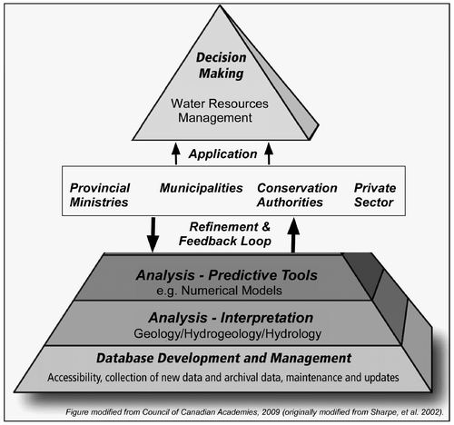
At a provincial level, a groundwater-based knowledge management strategy would retain as its overarching goal the quantitative understanding of the Province’s groundwater. Figure , which uses a Council of Canadian Academies (Citation2009) figure as a base, provides a framework for consideration. The strategy would require the long-term monitoring of the physical and chemical characteristics of Ontario’s flow systems as well as the management of this monitoring data. Jurisdictions at any level of government, as well as researchers and private sector companies involved in groundwater management, rely on these data and would be allowed ready access to groundwater-related information. This includes data, hydrogeologic/hydrologic interpretation and tools used for assessment and analysis (e.g. numerical models). These essential elements would vastly improve Ontario’s groundwater decision-making, and at the same time enhance the interaction between all parties. While upscaling the ORM Program model to the provincial level is a significant task, the possibilities of such an integrative effort are intriguing.
Figure 4. Possible shared provincial information and knowledge management system.
Local initiatives such as the ORM Program, whereby local-level (e.g. regional municipalities and conservation authorities) public-sector agencies have collectively pooled resources, can be effective in assuming this knowledge management responsibility. The program is helping to provide a direction forward to address this perceived lack of oversight regarding the management of Ontario’s water resources. It is anticipated that Provincial partnership and involvement would only strengthen various local initiatives that exist.
Acknowledgements
The discussion provided in this paper emanates from the authors’ experience and from water resource management discussions with staff at the various partner agencies (municipal government and conservation authority) of the Oak Ridges Moraine Hydrogeology Program (YPDT-CAMC), as well as the Province of Ontario and the Geological Survey of Canada. The opinions expressed remain the sole responsibility of the authors and do not specifically represent those of the partner agencies of the YPDT-CAMC program. This manuscript was significantly improved by comments on earlier versions received from technical staff: (1) from the program’s partner agencies (Russ Powell, Wendy Kemp, Mike Fairbanks and Bob Betcher), (2) from the consulting community (Lloyd Lemon at Genivar), (3) from Provincial staff (from the Environmental Monitoring and Reporting Branch of the Ministry of Environment), and (4) from journal reviewers (Gary Hunter plus two anonymous reviewers). In particular, critical review comments received from Emil Frind were also insightful and greatly enhanced the paper. The authors kindly thank all those that assisted in this endeavour.
Related Research Data
References
- Australian Local Government Association (ALGA). 2004. Local Government Knowledge Management Toolkit. http://unpan1.un.org/intradoc/groups/public/documents/apcity/unpan032548.pdf ( accessed May, 2013).
- Bajc, A. F., and J. Shirota. 2007. Three-dimensional mapping of surficial deposits in the Regional Municipality of Waterloo, southwestern Ontario. Groundwater Resources Study 3. Sudbury, ON: Geological Survey.
- Brown, J. S., and P. Duguid. 1998. Organizing knowledge. California Management Review 40(3): 90–111.
- Brunton, F. R., and C. Brintnell. 2011. Final update of early silurian stratigraphy of the Niagara escarpment and correlation with subsurface units across Southwestern Ontario and Great Lakes Basin. In Summary of field work and other activities 2011, Open File Report 6270, 30-1–30-11. Sudbury, ON: Ontario Geological Survey.
- Council of Canadian Academies. 2009. The sustainable management of groundwater in Canada. Report of the Expert Panel on Groundwater. http://www.scienceadvice.ca/uploads/eng/assessments%20and%20publications%20and%20news%20releases/groundwater/(2009-05-11)%20gw%20report.pdf ( accessed May, 2014).
- Durrant, F. 2001. Knowledge management in the context of government. Paper presented at the Caribbean Regional Ministerial Consultation & High Level Workshop on E-Government, Information and Communication Strategies in Public Sector Management. http://unpan1.un.org/intradoc/groups/public/documents/un/unpan015174.pdf ( accessed May, 2014).
- Gates, T. 1610. For the Colony in Virginea, Britannia. Lawes divine, morall, and martiall. London, U.K. http://memory.loc.gov/cgi-bin/ampage?collId=lhbcb&fileName=7018c/lhbcb7018c.db&recNum=2&itemLink=r%3Fammem%2Flhbcb%3A@field%28DOCID%2B@lit%28lhbcb7018cdiv6%29%29%237018c0037&linkText=1 ( accessed May, 2014).
- Gibbons, J. 2001. Managing the environment: A review of best practices. Toronto, ON: Executive Resource Group.
- Halton Regional Municipality. 2007. Sustainable Halton, water and waste water infrastructure. www.halton.ca/common/pages/UserFile.aspx?fileId=18500 ( accessed April, 2013).
- Hamilton, S. M., E. J. Matheson, C. N. Freckelton, and H. Burke. 2011. Ambient groundwater geochemistry program: The 2011 Aurora-Orillia study area and selected results for the bruce and Niagara peninsulas. In Summary of field work and other activities, 2011, Open File Report 6270, 32-1–32-11. Sudbury, ON: Ontario Geological Survey.
- Holysh, S., R. E. Gerber, and M. Doughty. 2011. Data management: The most under appreciated and under funded aspect of groundwater management. In Proceedings of GeoHydro 2011, Water and Earth: The Junction of Quaternary Geoscience and Hydrogeology; Joint Conference of the Canadian Chapter of the International Association of Hydrogeologists and the Canadian Quaternary Association, Quebec City, Quebec, 28–31, August 2011.
- Hunt, R. J., and C. Meine. 2012. Luna B. Leopold – Pioneer setting the stage for modern hydrology. Ground Water 50(6): 966–970.
- Karreman, D. 2001. Knowledge management and “organizational memory”: Remembrance and recollection in a knowledge intensive firm. http://www2.warwick.ac.uk/fac/soc/wbs/conf/olkc/archive/oklc3/papers/id312.pdf ( accessed May, 2013).
- KMK Consultants Ltd. 2007. Environmental study report: Class environmental assessment, water supply and storage capacity for Kleinburg-Nashville. Report prepared for the Regional Municipality of York. Brampton, ON.
- Miller, G. 2000. Changing perspectives. Environmental Commissioner of Ontario Annual Report 1999/2000. http://www.eco.on.ca/uploads/Reports%20-%20Annual/1999_2000/2000ar.pdf ( accessed May, 2014).
- Miller, G. 2012. Losing our touch. Environmental Commissioner of Ontario Annual Report 2011/2012, Part 2. http://www.eco.on.ca/index.php/en_US/pubs/annual-reports-and-supplements/losing-touch-part-2 ( accessed May, 2014).
- O’Connor, D. R. 2002. Report of the Walkerton inquiry, part two: A strategy for safe drinking water. Toronto, ON: Ontario Ministry of the Attorney General.
- Ontario Ministry of Environment (MOE). 2009. Water supply wells: Requirements and best management practices. PIBs #7333e, December. https://dr6j45jk9xcmk.cloudfront.net/documents/941/a-title-page-table-of-contents-and-chapter-1.pdf ( accessed May, 2014).
- Ontario Ministry of Environment (MOE). 2014. Data downloads: Well record data. http://www.ene.gov.on.ca/environment/en/resources/collection/data_downloads/index.htm#Well%20Records ( accessed January, 2014).
- Scott, J. C. 1970. Water Saga – A story of water management in Ontario 1956–1968. http://agrienvarchive.ca/download/water_saga_56-68.pdf ( accessed May, 2014).
- Sharpe, D. R., M. J. Hinton, H. A. J. Russell, and A. J. Desbarats. 2002. The need for basin analysis in regional hydrogeological studies: Oak Ridges moraine, Southern Ontario. Geoscience Canada 29: 3–20.
- Sharpe, D. R., S. E. Pullan, and G. Gorrell. 2011. Geology of the aurora high-quality stratigraphic reference site and significance to the Yonge Street buried aquifer, Ontario. Current Research 2011-1. Ottawa, ON: Geological Survey of Canada.
- Sibul, U., K. T. Wang, and D. J. Vallery. 1977. Groundwater resources of the Duffins Creek-Rouge River drainage basins. Water Resources Report 8. Toronto, ON: Ontario Ministry of Environment.
- Singer, S. N., C. K. Cheng, and M. G. Scafe. 2003. The hydrogeology of Southern Ontario, 2nd ed. Hydrogeology of Ontario Series, Report 1, Environmental Monitoring and Reporting Branch. Toronto, ON: Ministry of Environment.
- Turner, M. E. 1977. Oak Ridges aquifer complex. Water Resources Map 78-2. Toronto, ON: Ontario Ministry of Environment.