
Abstract
The Grand River, the largest river in southwestern Ontario, flows 311 km from Dundalk to Lake Erie. To mitigate flooding and low-flow extremes created by the removal of forest cover and wetlands, the Grand River Conservation Authority (GRCA) operates seven multi-purpose reservoirs. The ability to meet future human and ecological water needs depends both on the careful operation of the reservoir network and the protection, rehabilitation and enhancement of hydrologic and ecological functions provided by natural features such as the Waterloo Moraine, the largest moraine within the Grand River watershed. This moraine contains a complex set of stratigraphic and topographic elements, including extensive areas of sand hills and gravel terraces that readily allow precipitation to infiltrate and recharge several overburden aquifer systems. These aquifer systems discharge groundwater to the headwater wetlands and streams and contribute baseflow. This paper presents a watershed perspective of the importance of the Waterloo Moraine to the hydrology, water quality and ecology of the river system and urges the timely uptake of adaptive management and coordinated multi-scale planning (e.g. watershed, subwatershed and municipal) to safeguard the moraine’s natural functions.
La rivière Grand, le plus gros cours d’eau du Sud-Ouest ontarien, s’écoule sur 311 km depuis Dundalk jusqu’au lac Érié. Pour atténuer les inondations et les étiages extrêmes provoqués par la disparition du couvert forestier et des terres humides, l’Office de protection de la nature de la rivière Grand (GRCA) exploite sept réservoirs à usages multiples. La capacité de satisfaire aux besoins en eau des hommes et de l’environnement dépend à la fois de l’exploitation attentive du réseau de réservoirs, ainsi que de la protection, du rétablissement et de l’amélioration des fonctions hydrologiques et écologiques qui sont assurées par des entités naturelles comme la moraine de Waterloo, la plus grande moraine du bassin de la rivière Grand. Cette moraine comporte un ensemble complexe d’éléments stratigraphiques et topographiques, en particulier de grandes zones de dunes et de terrasses de gravier qui permettent aux précipitations de s’infiltrer et de recharger plusieurs systèmes aquifères granulaires. Ces aquifères déchargent l’eau souterraine dans les terres humides et les cours d’eau et contribuent ainsi au débit de base. Cet article présente, du point de vue des bassins versants, l’importance de la moraine de Waterloo pour l’hydrologie, la qualité de l’eau et l’écologie du réseau hydrographique et nous encourageons l’adoption rapide de la gestion adaptative et de la planification coordonnée sur plusieurs échelles (p. ex. bassin, sous-bassins, municipalités) afin de préserver les fonctions naturelles de la moraine.
Introduction
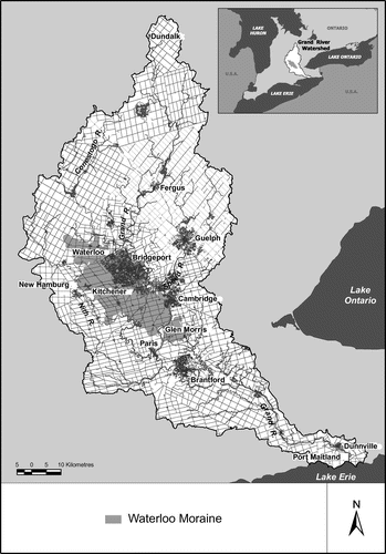
The Grand River watershed is the largest watershed in southwestern Ontario (Figure ). Stretching 311 km from Dundalk in the north to Port Maitland on Lake Erie, the Grand River and its tributaries drain an area of 6800 square km – the largest direct drainage basin to Lake Erie on the Canadian side of the lake.
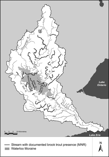
Figure 1. Areal extent of the Waterloo Moraine within the Grand River watershed, Ontario, Canada.
The Grand River system delivers vital services to almost 1 million watershed residents by providing a source for municipal drinking water and assimilating the wastewater from 30 different communities. It is widely used for water sports (e.g. canoeing, kayaking and rafting) and hiking along its banks. Sport fishing in certain reaches, most notably the tailwater fishery below the Shand Dam near Fergus, generates significant economic benefits (Smith Citation1997).
The river system is highly managed. To reduce burgeoning flood damages in the mid-twentieth century and maintain summer flows for water supply and water quality, the Grand River Conservation Authority (GRCA) built seven multi-purpose dams and reservoirs in the upper watershed between 1942 and 1976. The careful operation of these dams, in concert with advancements in urban wastewater and stormwater treatment and widespread adoption of beneficial management practices for land and water stewardship, has resulted in improvements to water quality and ecosystem health. Nonetheless, the complex interplay of natural hydrologic and ecological processes in the watershed is essential for maintaining or improving water quality and flow.
The Waterloo Moraine is a dominant physiographic feature in the central Grand River watershed and represents about 9% of the total land area of the watershed. This paper illustrates that the natural processes associated with the moraine extend considerably beyond the physical landform and directly benefit river hydrology, water quality and ecology, the nature and extent of which are not yet fully understood. Hence, the authors argue that multi-scale planning (e.g. watershed, subwatershed and municipal) and adaptive approaches must be better promoted and practiced to safeguard crucial natural watershed functions provided by the moraine.
The Waterloo Moraine
Many prominent landscape features in the Grand River watershed were formed from materials deposited or eroded by glaciers and glacial melt waters during the advance and retreat of the Huron, Georgian Bay, Ontario and Erie ice lobes in the Late Wisconsinan period (23,000–10,000 years ago) (Karrow and Morgan Citation2004). The central region of the watershed is characterized by a series of moraines, the most significant being the Paris, Galt and Waterloo Moraines.
The Paris and Galt Moraines were formed by the retreat of the Erie-Ontario ice lobes (Karrow and Morgan Citation2004). These end moraines contain irregular, stony knobs and ridges composed of till and kamey deposits, sand and gravel terraces, and swampy valley floors (Chapman and Putnam Citation1984). In contrast, the Waterloo Moraine, an interlobate moraine, was deposited where the Lake Ontario and Huron-Georgian ice lobes met. The advance and retreat of these glaciers resulted in a complex deposition of embedded till deposits, interspersed with layers of water-laid fine sands and gravels (Blackport Hydrogeology Inc. et al. Citation2009). As these glaciers retreated, meltwater paths were formed, eroding the landscape and substantially influencing the present-day drainage system in the central Grand River watershed (Chapman and Putnam Citation1984).
The unique location of the Waterloo Moraine, straddling the Carolinian life zone and the Great Lakes forest zone, is ecologically significant. A number of species reach their northern or southern range limits here. The topography of the Waterloo Moraine leads to site extremes which amplify this effect, so that southern species reach a little farther north on south-facing slopes and northern species reach a little farther south on northeast-facing slopes, leading to a wide variety of life and earth science features and high biodiversity (LGL Environmental Research Associates Citation2002).
Hydrologic functions
The Waterloo Moraine occupies a sub-regional topographic high. Highly permeable surficial and bedrock geological materials characteristic of the Waterloo Moraine regulate the transport and storage of water, thereby influencing critical local- and broader-scale hydrologic functions in the Grand River watershed. Almost all precipitation falling on the moraine is infiltrated. Storage delays the movement of water to the river system, reducing peak flows in the rivers and sustaining baseflow as the groundwater storage discharges slowly through seeps and springs into surface water systems. Groundwater discharge-supported wetlands, products of the physiographic landscape features and the groundwater regime, provide vital ecological functions on the Waterloo Moraine and further regulate the movement of surface water and groundwater.
Figure shows recharge areas in the central watershed. Within the southern part of the moraine, recharge is seen to be fairly uniform at high values between 300 and 500 mm/year, while in the northern part it is more variable, ranging between a low of 50 to a high of 500 mm/year. These areas of infiltration support groundwater-dependent features including river reaches where groundwater discharge contributes to baseflow. Corresponding reaches are shown in Figure , ranked according to discharge magnitude (discharge negative; recharge positive).
Figure 2. Recharge areas in the central Grand River region. Watershed-scale recharge was derived from the water budget for the Grand River watershed (AquaResource Inc. 2009).
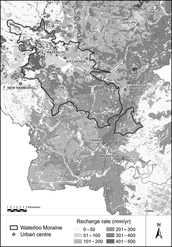
Figure 3. Stream reaches with major groundwater discharge in the central Grand River region. Linkages between discharge points along a reach of the Grand and corresponding contributing areas within the moraine are indicated by particle tracks.
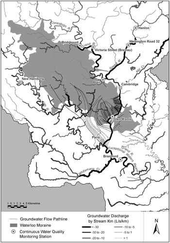
Groundwater discharge is critical not only to local streams within the moraine area, but also to larger rivers beyond the boundaries of the moraine. The linkage between recharge within the moraine and groundwater discharge outside the moraine area is demonstrated by means of a limited particle tracking analysis (Figure ), using a regional groundwater flow model. This model was developed for the GRCA by AquaResource Inc. (Citation2009) to simulate groundwater flow within the watershed, using the software package FEFLOW (WASY Citation2005). The particle tracks were generated by releasing particles along a reach of the Grand River between Cambridge and Paris and allowing them to track upgradient through the groundwater system. The results show that for the northern part of this reach near Cambridge, groundwater discharge originates directly from the adjoining southern part of the moraine, while for the southern part of the reach near Paris, at least some of the groundwater discharge originates from the more distant central part of the moraine. These results support the concept of a linkage between groundwater recharge on the Waterloo Moraine and discharge to surface water features, both locally and in critical reaches of the Grand River downgradient of the moraine. This linkage is to be expected because the moraine plays a key role in recharging the regional groundwater flow system. A more detailed picture showing the recharge/discharge relationship for all watercourses in the watershed could be obtained by placing particles along all streams.
Groundwater discharge locations in the central river reaches were corroborated with an infrared imaging study conducted in January 2012 by the GRCA and the University of Waterloo (Conant Citation2012). This study used temperature as a tracer and found 272 thermal anomalies (i.e. potential groundwater discharge sites), providing visual evidence that a significant volume of groundwater is discharged from the west bank of the Grand River between Glen Morris and Paris. The GRCA’s summer low flow calculations and spot flow gauging through this reach provide additional verification. Low flow calculations (GRCA Citation2012) indicate that approximately 1.6 m3/s of flow is gained in the Grand River between Cambridge and Brantford, and spot flow gauging, conducted by the GRCA in the same reach during dry conditions, indicates that streamflow volumes increase by about 3.5 m3/s (AquaResource Inc. Citation2009).
The influx of cold groundwater from the Waterloo Moraine to the Grand River also provides substantial water quality benefits. Groundwater discharges help to dilute pollutants from upstream wastewater treatment plants and runoff from urban and rural areas. In the reach between Cambridge and Paris, groundwater inputs, combined with the river’s steep gradient and limited direct drainage, contribute to water quality improvements farther downstream, including moderating temperatures and increasing dissolved oxygen levels (Loomer and Cooke Citation2011). In fact, the Grand River between Cambridge and Paris is known as the “recovery reach” (Scott and Imhof Citation2005). Groundwater discharges also likely facilitate important natural biogeochemical processes within the hyporheic zone, which is recognized as an important site for the transformation and storage of nutrients within lotic systems (United States Environmental Protection Agency [US EPA] Citation2000; Maiolini and Bruno Citation2007). This important hydrologic function is critical for the assimilation of upstream nutrient inputs into higher tropic levels (e.g. macrophytes, algae and invertebrates), thereby improving water quality for downstream uses, including municipal water supplies.
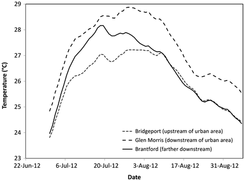
Groundwater discharge from the Waterloo Moraine helps to moderate summer water temperature extremes. Summer conditions are usually hot and dry. Typically, overland runoff is reduced due to active evapotranspiration and soil absorption. Much of the summer flow in the central region is augmented by upstream reservoirs. Figure compares the running 30-day average maximum summer water temperatures in 2012 at continuous water quality stations in Bridgeport (Kitchener), Glen Morris and Brantford (see Figure for the location of stations). Downstream from Bridgeport, the river flows through the urbanized area of Waterloo Region. When the water reaches Glen Morris (downstream of the urban area) the summer water temperature is as much as 1.0–1.3°C warmer, likely due to an urban heat island effect. Surface urban heat islands degrade water quality through thermal pollution and shift the thermal regimes of surface waters, which can affect all aspects of aquatic life including metabolism and reproduction (US EPA Citation2008). Farther downstream near Brantford, the water temperature is as much as 0.9–1.2°C cooler, likely due to the discharge of cold groundwater in the river reach below Paris, combined with good riparian shading.
Figure 4. Thirty-day running average maximum daily temperatures in the Grand River at Bridgeport, Glen Morris and Brantford.
Linking hydrologic functions to habitat
The Waterloo Moraine, with its complex topography and geology, recharge and discharge wetlands, drainage patterns and groundwater discharge areas, supports diverse aquatic and terrestrial ecosystems. Studies have illustrated that landscape attributes of a watershed such as geology and/or climate are useful predictors of the type and extent of the aquatic (e.g. fish and benthos assemblages) or terrestrial communities that are or may be present on the landscape (Ontario Ministry of Natural Resources [OMNR] and GRCA, Citation1998/2005; OMNR and Watershed Science Centre [WSC] Citation2002; Stanfield and Kilgour Citation2006; Yates Citation2008). For example, the occurrence of a geologic feature such as coarse sediment (e.g. gravel deposits) is a strong predictor of the presence of cold-water streams and brook trout (Salvelinus fontinalis) (Stanfield and Kilgour Citation2006; Yates Citation2008). Cold-water streams and significant groundwater-fed wetland complexes are frequently present within the hummocky terrain and gravel terraces of the Waterloo Moraine.
A geospatial analysis of the 520 km of streams originating from the Waterloo Moraine revealed that 30% (156 stream km) are cold-water streams, which is a far greater proportion than the average 14% across the entire watershed. This analysis was based on available data layers from OMNR Land Information Ontario (Citation2011a, Citation2011b). Further, many streams emanating from the Waterloo Moraine are fed by associated discharge wetlands on the moraine or down gradient from it. A total of 70 wetland complexes have been designated Provincially Significant Wetlands (OMNR Land Information Ontario Citation2011c) and most of these provide critical groundwater recharge or discharge functions. Wetlands, which represent about 7% of the areal extent of the Waterloo Moraine, provide essential spawning and nursery habitat for a number of fish species as well as important habitat for waterfowl and wildlife (OMNR and GRCA Citation1998/2005; LGL Environmental Research Associates Citation2002).
Brook trout are a sentinel species associated with the cold-water streams draining the Waterloo Moraine. Their presence is an indicator of high-quality water, strong baseflows and stable thermal regimes. Groundwater discharged to streams provides the necessary cold-water environments or temperature regimes for brook trout spawning areas and embryo and juvenile development (Currie and Noakes Citation1995; GRCA et al. Citation2005). Some of the best brook trout habitats in the Grand River watershed are in streams originating from the Waterloo Moraine (e.g. Cedar, Alder and Washington Creeks) (Figure ). The local benefits of the groundwater discharges to the biodiversity and resiliency of the aquatic ecosystem in the Grand River watershed are obvious. However, the discharges from the moraines also support a larger, unique and biodiverse aquatic ecosystem in the Grand River between Paris and Brantford and in the Nith River from New Hamburg to Paris (OMNR and GRCA Citation1998/2005).
Figure 5. Streams on the Waterloo Moraine with confirmed presence of brook trout (Salvelinus fontinalis). Their presence is strongly associated with the moraine complexes in the watershed.
Accumulations of groundwater discharges from the Waterloo, Paris and Galt Moraines converge in the Grand River between Paris and Brantford, also known as the Exceptional Waters reach. “Exceptional Waters” is a term used to describe rivers of outstanding quality and productivity, capable of maintaining healthy, sustainable terrestrial and aquatic environments (Imhof Citation2006). This reach is known for its unique aquatic habitats, biodiversity and the mixture of healthy cold-water, mixed-water and warm-water fish communities. Studies suggest that the conditions are directly attributable to the large amount of groundwater culminating in this reach (OMNR and GRCA Citation1998/2005; Scott and Imhof Citation2005). The cold-water fish communities are concentrated in the areas of highest groundwater discharge. The groundwater moderates water temperature extremes and provides suitable thermal refuges and seasonal spawning sites for fish species like rainbow and brown trout, both indicators of good water quality (Scott and Imhof Citation2005). Consequently, the Grand River between Paris and Brantford has some of the best rainbow trout fishing in southern Ontario.
The diverse biophysical landscape features of the Waterloo Moraine also support unique and exceptional aquatic-terrestrial ecosystems. The Waterloo Moraine has more documented species of conservation interest than other areas of the watershed (OMNR Natural Heritage Information Centre Citation2012). Species of conservation interest include species designated “at risk” (e.g. threatened or endangered species) or of “special concern” (e.g. species experiencing declining populations) or species considered vulnerable, such as colony-nesting birds. The current provincially listed at-risk species occurring on the Waterloo Moraine include the milksnake (Lampropeltis triangulum), snapping turtle (Chelydra serpentina), least bittern (Ixobrychus exilis), wavy-rayed lamp mussel (Lampsilis fasciola) and hooded warbler (Wilsonia citrina).
Perhaps the “at risk” species most influenced by the physiographic features of the Waterloo Moraine is the Jefferson salamander (Ambystoma jeffersonianum). It only exists where suitable vernal pools or wetlands exist. Vernal pools and wetlands collect surface runoff and are prominent features associated with the hummocky terrain of the Waterloo Moraine (Blackport Hydrogeology Inc. et al. Citation2009). The protection and recovery of the Jefferson salamander requires that both surface water hydrology and groundwater contributions are not disrupted, altered or diminished (Jefferson Salamander Recovery Team [JSRT] Citation2010). This species is highly dependent on the key hydrologic functions of the Waterloo Moraine for its survival.
The historical average cumulative number of species of conservation interest occurrences per square km on the Waterloo Moraine, from more than a century of records, was estimated to be 11.8, while for the remainder of the watershed it was estimated to be only 7.7 (OMNR Natural Heritage Information Centre Citation2012). This illustrates the greater richness in species of conservation interest on the Waterloo Moraine than in the rest of the watershed. An analysis of data collected by the Ontario Ministry of Natural Resources over the last 20 years shows that the occurrences of species of conservation interest on the Waterloo Moraine have fallen dramatically to 1.3 species per square km, likely due to the effects of land use including agricultural production and urbanization. Much of the urban settlement in the Grand River watershed is on the Waterloo Moraine as it provides a substantive water supply for human uses. A geospatial analysis of land use data (OMNR Southern Ontario Land Resource Information System Citation2004; Regional Municipality of Waterloo Citation2011) shows that urban land use covers 30% (16,987 hectares) of the moraine. This is proportionately much greater than the approximately 7% (38,636 hectares) of urban land cover in the entire watershed.
A watershed planning perspective
The Waterloo Moraine is experiencing sizeable development pressures, major aggregate extraction, progressive water takings and added stress from the impacts of a changing and variable climate. This has led to increasing concerns about aquifer contamination, hydrologic stress and impairment to the vital water recharge and discharge functions, and ensuing changes to the subsisting hydrology and ecology of the river system. Studies have shown that urban development can negatively affect key hydrologic and ecological functions. For example, the increase in impervious cover (e.g. paved roads, parking lots, roofs, etc.) can result in decreased baseflows in streams (Schueler et al. Citation2009; Klosterman Citation2012), reduced presence of fish, benthos assemblages and instream habitat (Stanfield and Kilgour Citation2006; Stanfield et al. Citation2006; Stantec Consulting Ltd. Citation2009), and diminished functionality and presence of environmentally sensitive landscapes such as wetlands (Harbor Citation1994; Wright et al. Citation2006). Agricultural land use has been shown to alter infiltration rates and negatively impact baseflows in streams (Dunne and Leopold Citation1978), and affect fish and benthos assemblages (Stanfield and Kilgour Citation2006) and wetlands (Whiteley Citation1979). The high permeability of the moraine sediments increases the risk of urban and rural contaminants entering the groundwater where they can remain undetected for decades (Bester et al. Citation2006; Blackport Hydrogeology Inc. et al. Citation2009). Thus, both urban development and rural land-use practices continue to be a significant risk to the integrity of the hydrologic and ecological functions of the moraine.
A watershed approach to understanding the natural processes and interdependencies, and the cumulative effects of stressors on the river system is needed to spur integrative, collaborative and complementary management actions by the GRCA and various levels of government. For example, the development of a watershed-wide classification system that ranks the relative hydrologic functionality of natural units on the landscape, including the Waterloo Moraine, and a watershed-wide natural heritage strategy would be useful planning tools for defining areas for further research and enhanced protection.
To deal with the complex array of watershed water issues, the GRCA has brought together representatives from all levels of government with responsibilities for managing water to develop an overarching water management plan for the Grand River watershed. The goals of the plan are to:
improve water quality to improve river health and reduce its impact on Lake Erie;
ensure sustainable water supplies for communities, economies and ecosystems;
reduce flood damage potential, and
increase resiliency to deal with climate change.
The partners to the plan will identify and undertake complementary actions to tackle the predominant water management challenges to ensure that the river system will continue to support environmental, social and economic vitality. Understanding and protecting key hydrologic and ecological processes associated with the Waterloo Moraine that contribute to maintaining or improving water quality, flow conditions and ecological health in the entire river system are acknowledged as essential components of the management strategy.
Science-based studies and other investigations on the Grand River such as the ones being carried out for source protection planning under the Ontario Clean Water Act and by the Ontario Geological Survey and the Geological Survey of Canada are fundamental to improving our understanding of the key hydrologic processes associated with the Waterloo Moraine at a regional scale.
At the subwatershed scale, detailed studies contribute to a more in-depth understanding of the natural processes and functions supported by the moraine. In the Grand River watershed, subwatershed plans are done before significant development occurs, to:
characterize the complex interactions among and between surface water, groundwater, terrestrial and aquatic ecosystems at a subwatershed scale;
maintain or enhance the integrity and health of the natural environment at a subwatershed scale and its resiliency in the face of development pressures and environmental stressors, and
promote informed decision-making through the completion of in-depth, integrated technical studies that assess existing and potential cumulative effects.
Subwatershed plans include recommendations about what measures need to be put in place to protect the natural system and maintain or enhance its critical functions while allowing development to proceed. These recommendations are implemented chiefly through municipal planning documents such as official plan amendments, subsequent land-use planning and approvals under legislation from provincial agencies, municipalities and the GRCA.
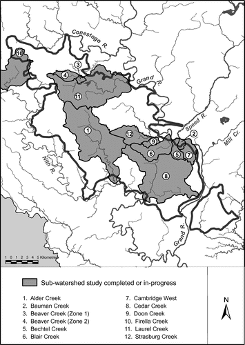
Several subwatershed plans for various-sized catchments or combined catchments within the Waterloo Moraine have been undertaken. Over the past 20 years, major studies have been completed for Laurel Creek, Strasburg Creek, Blair, Bechtel and Bauman Creeks, Firella Creek, Cedar Creek and Alder Creek. Studies are in progress for Beaver Creek and Devil’s, Cruickston and Newman Creeks (Cambridge West) (Figure ).
Figure 6. Subwatershed plans on the Waterloo Moraine.
Since the first subwatershed plans on the Waterloo Moraine were completed in the early 1990s, additional hydrogeological and ecological studies have contributed to a better understanding of the inherent natural functions of the moraine. New technologies and best management approaches designed to mimic or restore the natural functions of the landscape have been devised and put into place. Land use policies, guided by municipal official plans, have been amended to guide land and infrastructure development in keeping with the subwatershed plan’s recommendations. Other actions such as stewardship and conservation activities on private lands have been undertaken through programs such as the Rural Water Quality Program funded by the Region of Waterloo, other municipalities and additional partners and delivered by the Grand River Conservation Authority. These programs encourage such activities as riparian plantings, stream buffers, fencing livestock from streams and manure storage.
However, despite these actions, there is growing concern that the natural hydrologic and ecological processes and functions of the Waterloo Moraine continue to be altered. Few systematic approaches to monitor the operational success of engineered designs and best practices, detect failures or underperformance and determine the underlying causes, or rectify problems post-development, have been put in place. Typically, the indicators used to gauge change are targeted to specific outcomes, or monitoring is being done only for a very short time after completion of development. Useful records on the long-term performance of these measures are scarce and, consequently, whether mitigative measures can be fully successful in maintaining or restoring a complex hydrogeological system to pre-development conditions or protecting or enhancing biodiversity remains an open question.
To deal with complexity and uncertainty, an adaptive approach is advocated (Williams et al. Citation2009; Conservation Ontario Citation2010; Mitchell Citation2010). An adaptive management approach promotes continuous learning and improvement through the cycle of planning, implementing, monitoring and evaluating. It is an iterative approach that requires sound science and decision-making tools, agency collaboration, willingness of decision-makers to learn and adjust practices, and flexible institutional arrangements that allow for timely change over the long term (McLain and Lee Citation1996; Allan and Curtis Citation2005). This approach fosters a collective understanding of the natural processes at play, builds on multi-scale planning and allows watershed managers, provincial and municipal planners and decision-makers to incrementally introduce new and more effective management approaches, policies and guidelines over time.
An adaptive approach to subwatershed planning on the Waterloo Moraine was introduced in a functional drainage study for the upper Blair Creek catchment (Stantec Consulting Ltd. Citation2009). The study recommended that stormwater management measures be designed to maintain natural infiltration rates, mitigate increases in flood flows, compensate for the loss of depression storage, reduce stream erosion, prevent increases in stream water temperatures and maintain critical inflows into sensitive aquatic habitats and wetlands within and downstream of the catchment. The Blair Creek study acknowledged that the plan’s success would be determined by appropriate and timely monitoring and reporting for early detection of adverse impacts, so that remedial steps can be taken immediately if necessary. Pre-development monitoring at the subwatershed scale was started in 2006. In 2009, the City of Kitchener allocated $100,000 per year from development charges for system-wide monitoring and state-of-the-environment reporting to 2020. In addition, at the site level, developers are required to monitor before, during and after construction.
While new knowledge about the natural processes associated with the Waterloo Moraine is being generated from recent investigative studies, additional scientific research coupled with a systematic assessment of the overall efficacy of engineered measures, protective strategies and stewardship activities already implemented on the moraine is needed. Where failures or deficiencies are discovered, innovative remedial actions designed to avoid past inadequacies should be implemented, monitored and assessed. In addition, the true cost of installing and maintaining engineered measures in perpetuity, including future remediation costs to mitigate adverse or unanticipated negative impacts on water quality, river flow and terrestrial and aquatic health, should be calculated and factored into planning decisions. Deferring development in highly sensitive areas may be the best option for protecting critical functional areas of the moraine, until and unless it can be clearly demonstrated if and how they can be maintained or enhanced in perpetuity. Future planning must build on the lessons learned, while continuing to search for innovative approaches to preserve natural functions.
Conclusion
This paper demonstrates that the Waterloo Moraine supports complex natural processes that significantly affect the hydrogeology, hydrology and ecology of the Grand River watershed. Understanding of these interactions is imprecise, but improving as more monitoring and research is undertaken. Recent investigative studies show that the contributions of the moraine to groundwater recharge and discharge extend well beyond the physical landform and influence water flow, temperatures and quality and associated terrestrial and aquatic habitats in the central Grand River.
The Waterloo Moraine is experiencing change associated with urbanization, agricultural production, aggregate extraction and climate change. These modifications compromise the integrity of the moraine’s natural functions and processes, despite current planning and implementation efforts. Continuing landscape change is inevitable and, to protect and restore key processes and functions, a renewed multi-scale planning approach that integrates adaptive management is advocated. To be effective, this approach must embrace the tenet of continuous improvement through long-term monitoring and investigation, analysis and collective learning, and timely, collaborative action. While not without its challenges, a multi-scale adaptive planning approach is a viable planning option which must be actively pursued without delay.
Acknowledgements
This paper represents the collective effort of a number of staff members at the Grand River Conservation Authority. Contributors to the content include Dwight Boyd, Beth Brown, Sonja Strynatka, Crystal Allan, Nigel Ward, Nancy Davy and Warren Yerex (retired). Bryan McIntosh and Kevin Tupman undertook the geospatial analysis of data layers obtained from the OMNR, Land Information Centre, the Region of Waterloo, and the GRCA. Jeff Pitcher created the figures used in the article. Art Timmerman, OMNR (Guelph District), provided information regarding the presence of brook trout in the watershed.
Related Research Data
References
- Allan, C., and A. Curtis. 2005. Nipped in the bud: why regional scale adaptive management is not blooming. Environmental Management 36(3): 414–425.
- AquaResource Inc. 2009. Integrated water budget report: Grand River watershed. Prepared for Grand River Conservation Authority. Kitchener, ON: AquaResource Inc.
- Bester, M., E. O. Frind, J. W. Molson, and D. L. Rudolph. 2006. Numerical investigation of road salt impact on an urban well field. Ground Water 44(2): 165–175.
- Blackport Hydrogeology Inc., Blackport and Associates Ltd., and AquaResource Inc. 2009. Review of the state of knowledge for the Waterloo and Paris/Galt Moraines. Prepared for the Land and Water Policy Branch, Ontario Ministry of Environment. http://www.ene.gov.on.ca/stdprodconsume/groups/lr/@ene/@resources/documents/resource/stdprod_078244.pdf ( accessed October, 2012).
- Chapman, L. J., and D. F. Putnam. 1984. The physiography of southern Ontario. Ontario Geological Survey, Special Volume 2, 3rd ed. Toronto: University of Toronto Press.
- Conant, B. 2012. Aerial infrared thermography survey to identify groundwater discharge along the Grand River, between Glen Morris and Paris Ontario. Prepared for Grand River Conservation Authority. Waterloo, ON: University of Waterloo.
- Conservation Ontario. 2010. Integrated watershed management: Navigating Ontario’s future summary report. Newmarket: Conservation Ontario.
- Currie, R. A., and D. L. G. Noakes. 1995. Groundwater and the selection of spawning sites by brook trout (Salvelinus fontinalis). Canadian Journal of Fisheries and Aquatic Sciences 52(8): 1733–1740.
- Dunne, T., and L. B. Leopold. 1978. Water in environmental planning. New York: W. H. Freeman and Company.
- Grand River Conservation Authority (GRCA). 2012. GRCA monitoring network: Summary report. http://www.grandriver.ca/index/document.cfm?Sec=2&Sub1=6&Sub2=1 ( accessed October, 2012).
- Grand River Conservation Authority (GRCA). Parish Geomorphic, Trout Unlimited Canada, University of Guelph, and University of Waterloo. 2005. Establishing environmental flow requirements for selected streams in the Grand River watershed. Cambridge: Grand River Conservation Authority.
- Harbor, J. M. 1994. A practical method for estimating the impact of land-use change on surface runoff, groundwater recharge and wetland hydrology. Journal of the American Planning Association 60(1): 95–108.
- Imhof, J. 2006. The exceptional waters approach: A community-based management approach. http://www.grandriver.ca/WaterForum/Imhof06.pdf ( accessed September, 2012).
- Jefferson Salamander Recovery Team (JSRT). 2010. Recovery strategy for the Jefferson salamander (Ambystoma jeffersonianum) in Ontario. Ontario Recovery Strategy Series. Prepared for the Ontario Ministry of Natural Resources, Toronto, ON: Queen's Printer for Ontario.
- Karrow, P. F., and A. Morgan. 2004. Glaciation and recent events in the Grand River watershed, in Towards a Grand Sense of Place, edited by G. Nelson, 21–34. Waterloo: University of Waterloo Geography Publication Series.
- Klosterman, K. B. 2012. The role of structural stormwater best management practices, impervious surfaces and natural factors on base flow in Massachusetts. Masters of Regional Planning thesis, Amherst: University of Massachusetts.
- LGL Environmental Research Associates. 2002. Cedar Creek scoped subwatershed study. Prepared for the Grand River Conservation Authority, Regional Municipality of Waterloo and Township of North Dumfries, Draft. Cambridge, ON: LGL Environmental Research Associates.
- Loomer, H. A., and S. E. Cooke. 2011. Water quality in the Grand River watershed: Current conditions and trends (2003–2008). Cambridge: Grand River Conservation Authority.
- Maiolini, B., and M. C. Bruno. 2007. The river continuum concept revisited: Lessons from the Alps. Alpine Space – man and environment, Volume 3: The water balance of the Alps. Innsbruck: Innsbruck University Press. http://www.uibk.ac.at/alpinerraum/publications/vol3/b_maiolini.pdf ( accessed October, 2012).
- McLain, R. J., and R. G. Lee. 1996. Adaptive management: Promises and pitfalls. Environmental Management 20(4): 437–448.
- Mitchell, B. ed. 2010. Resource and environmental management in Canada. 4th ed. Toronto: Oxford University Press.
- Ontario Ministry of Natural Resources (OMNR) and Grand River Conservation Authority (GRCA). 1998/2005. A Community-based approach to fisheries management in the Grand River watershed. http://www.grandriver.ca/fisheriesmanagement/fishplan_cd.pdf ( accessed September, 2012).
- Ontario Ministry of Natural Resources (OMNR) and Watershed Science Centre (WSC). 2002. Adaptive management of stream corridors in Ontario. http://www.conservation-ontario.on.ca/library?view=document&id=51:adaptive-management-of-stream-corridors-in-ontario-watershed-science-centre-trent-university-2001&catid=32:reports ( accessed October, 2012).
- Ontario Ministry of Natural Resources (OMNR) Land Information Ontario. 2011a. Aquatic resource area summary layer. http://publicdocs.mnr.gov.on.ca/View.asp?Document_ID=16159&Attachment_ID=33912 ( accessed January, 2012).
- Ontario Ministry of Natural Resources (OMNR) Land Information Ontario. 2011b. Ontario hydro network watercourse and waterbody layers. http://publicdocs.mnr.gov.on.ca/view.asp?document_id=21305&attachment_id=44869 ( accessed January, 2012).
- Ontario Ministry of Natural Resources (OMNR) Land Information Ontario. 2011c. Natural resources and values information system wetland unit layer. http://publicdocs.mnr.gov.on.ca/View.asp?Document_ID=9006&Attachment_ID=16922 ( accessed August, 2012).
- Ontario Ministry of Natural Resources (OMNR) Natural Heritage Information Centre. 2012. Rare species, vegetation types, and wildlife concentration areas occurrence data. http://nhic.mnr.gov.on.ca/MNR/nhic/data ( accessed August, 2012).
- Ontario Ministry of Natural Resources (OMNR) Southern Ontario Land Resource Information System. 2004. Built up layer. http://publicdocs.mnr.gov.on.ca/view.asp?Document_ID=12949&Attachment_ID=25301 ( accessed August, 2012).
- Regional Municipality of Waterloo. 2011. Digital urban area boundary layer. http://grims.grandriver.ca/grin/metadata/entities/mun_RMOW_ROP_URBAN_AREA_BOUNDARY.htm ( accessed August, 2012)
- Schueler, T. R., L. Fraley-McNeal, and K. Cappiela. 2009. Is impervious cover still important? A review of recent research. Journal of Hydrological Engineering 14(4): 309–315.
- Scott, R., and J. Imhof. 2005. Exceptional waters reach: Paris to Brantford. Cambridge: Grand River Conservation Authority.
- Smith, A. 1997. Economic impact analysis of sport fishing on the upper Grand River: A methodology. Guelph: School of Rural Planning and Development, University of Guelph.
- Stanfield, L. W., S. F. Gibson, and J. A. Borwick. 2006. Using a landscape approach to identify the distribution and density patterns of Salmonids in Lake Ontario tributaries. American Fisheries Society Symposium 48: 601–621.
- Stanfield, L. W., and B. W. Kilgour. 2006. Effects of percent impervious cover on fish and benthos assemblages and instream habitats in Lake Ontario tributaries. American Fisheries Society Symposium 48: 577–599.
- Stantec Consulting Ltd. 2009. Upper Blair Creek (Kitchener) functional drainage study. Prepared for the City of Kitchener, Kitchener, ON: Stantec Consulting Ltd.
- United States Environmental Protection Agency (US EPA). 2000. Proceedings of the Ground-water/Surface-water Interactions Workshop. EPA/542/R-00/007. Washington, DC: United States Environmental Protection Agency, Solid Waste and Emergency Response.
- United States Environmental Protection Agency (US EPA). 2008. Reducing urban heat islands: Compendium of strategies. Washington, DC: Climate Protection Partnership Division, Office of Atmospheric Programs, United States Environmental Protection Agency. http://www.epa.gov/hiri/resources/compendium.htm ( accessed October, 2012).
- WASY. 2005. FEFLOW 5.2: Finite Element Subsurface Flow & Transport Simulation System. Reference manual, user’s manual and white papers. Berlin: Institute for Water Resources Planning and Systems Research Ltd. www.wasy.de ( accessed October, 2012).
- Whiteley, H. R. 1979. Hydrologic implications of land drainage. Canadian Water Resources Journal 4(2): 12–19.
- Williams, B. K., R. C. Szaro, and C. D. Shapiro. 2009. Adaptive management: The US Department of the Interior technical guide. Adaptive Management Working Group, Washington, DC: US Department of the Interior.
- Wright, T., J. Tomlinson, T. Schueler, K. Cappiella, A. Kitchell, and D. Hirschman. 2006. Direct and indirect impacts of urbanization on wetland quality. Prepared for the Office of Wetlands, Oceans and Watersheds, United States Environmental Protection Agency. Ellicott City, MD: Center for Watershed Protection.
- Yates, A. G. 2008. Development, testing and application of stressor gradients in rural, headwater streams in southwestern Ontario. PhD thesis, University of Western Ontario.