
Abstract
The Waterloo Moraine is a historic and continuing groundwater resource for the growing Region of Waterloo in southern Ontario, Canada, providing hundreds of thousands of litres of fresh water daily to the regional water supply. The complex stratigraphy of the Moraine is characterized by a system of multiple aquifers separated by regionally discontinuous aquitards, complicating resource assessments. The Region’s extensive monitoring and production well network has been sampled repeatedly over the last four decades, providing insights into how long-term pumping and urban development have affected aquifer geochemistry. Various environmental tracers were used to identify groundwater residence time and mixing including 3H, 3H/3He, CFCs, SF6, 14C, and 4He. Studies on the Waterloo Moraine provided important contributions to the application of these environmental tracers by validating unsaturated zone transport theory and documenting the effects of localized atmospheric CFC contamination. These studies have also provided important information about groundwater flow and mixing in the Moraine. Both historical and recent hydrogeological studies identified urban applications of road deicers (salt) and rural agricultural practices (nitrate loadings) as potential problems for future use of groundwater as a domestic water supply for the region, with Cl and NO3-N concentrations in some areas approaching 900 and 17 mg/L, respectively. The effects of these urban and rural contaminant issues are explored, and efforts to mitigate and reduce the impact, including the effects of best (beneficial) management practices, are discussed. The potential impacts of these non-point source contaminants on the public water supply should be considered when planning new residential developments.
La moraine de Waterloo a été et continue d’être une ressource en eau souterraine pour la région de Waterloo dans le sud de l’Ontario (Canada). Chaque jour, on y puise des centaines de milliers de litres d’eau douce qui alimentent cette région en pleine croissance. La stratigraphie complexe de la moraine est caractérisée par un système d’aquifères multiples, séparés par des aquitards discontinus à l’échelle régionale, ce qui complique l’évaluation des ressources. Le vaste réseau de puits de production et de surveillance de la région a été échantillonné à maintes reprises au cours des quatre dernières décennies, ce qui a permis de comprendre comment le pompage sur une longue période et le développement urbain influence la géochimie du système aquifère. Divers traceurs environnementaux ont été utilisés pour déterminer le temps de résidence et les mélanges dans l’eau souterraine, notamment le 3H, le rapport 3H/3He, le SF6, le 14C et le 4He, ainsi que le CFC. Les études de la moraine de Waterloo constituent d’importantes contributions à l’application de ces traceurs environnementaux, car elles permettent de valider la théorie sur leur transport dans les zones non saturées et de documenter les effets de la contamination atmosphérique localisée par les CFC. Ces études ont également fourni d’importantes informations au sujet de l’écoulement et des mélanges de l’eau souterraine dans la moraine. Il ressort des études hydrogéologiques passées et récentes que l’utilisation en milieu urbain de sels déglaçants sur les routes et les pratiques agricoles rurales (charges de nitrates) sont des problèmes potentiels pour l’utilisation future de l’eau souterraine comme source d’eau domestique pour la région, alors que les concentrations de Cl et de NO3-N dans certains secteurs approchent respectivement 900 et 17 mg/L. L’article décrit les effets de ces problèmes de contamination en milieux urbains et ruraux, et discute des efforts visant à atténuer et réduire les impacts, incluant les effets d’une pratique de saine gestion. Les impacts potentiels des sources de contaminants non ponctuelles sur l’approvisionnement public en eau devraient être considérés lors de la planification de nouveaux développements résidentiels.
Introduction
Geochemical investigations of the Waterloo Moraine aquifer over the past 40 years reflect the development and maturation of the science of chemical hydrogeology and the study of regional water supply aquifers. While the aquifer was studied by numerous groups in the 1940s, the first geochemical samples were not collected and reported until the mid-1970s (Nowicki Citation1976; Béland Citation1977). These studies were of limited extent, yet the results provided an important baseline for subsequent work investigating regional groundwater flow and mixing, and identifying changes resulting from anthropogenic activities. Repeated and expanding geochemical sampling has enabled regional planners and those who study the hydrostratigraphy of the Moraine to establish relative groundwater ages and mixing scenarios for aquifer systems (Fritz et al. Citation1991; Johnston et al. Citation1998; Stotler et al. Citation2011). Several of these studies and many others have been concerned with the geochemical evidence of anthropogenic influence on the water supply for the Region of Waterloo. Road salt impacts, rural agricultural practices and, most recently, organic contaminants from the Region’s industrial base have all affected groundwater quality, and have been monitored using geochemical and isotopic tools (Nowicki Citation1976; Woeller Citation1982; Fritz et al. Citation1991; Johnston Citation1994; Johnston et al. Citation1998; Stotler Citation2003; Stotler et al. Citation2005, Citation2011; el Mugammar Citation2006). Hydrogeochemical analysis, combined with understanding of the physical system, has provided important insight towards understanding flow paths and the effects of laterally discontinuous aquitards (Johnston et al. Citation1998; Stotler et al. Citation2011). By the time the most recent study (Stotler et al. Citation2011) was published, the Region of Waterloo had begun to compile a database for geochemical trends across the region, the most significant of which were summarized in the Clean Water Act Issues Assessment, Revised v. 3 (Region of Waterloo Citation2012).
The present paper discusses insights gained from investigations of the Waterloo Moraine aquifer. Investigations using various environmental tracers aided in the development of their widespread application. Repeated geochemical and isotopic analyses over time provide the opportunity to explore the implications of land use and development on aquifer geochemistry (Johnston Citation1994; Johnston et al. Citation1998; el Mugammar Citation2006; Stotler et al. Citation2011).
The Waterloo Moraine
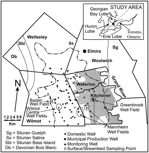
The Waterloo Moraine is located in the Regional Municipality of Waterloo (RMOW, or the Region) and underlies the Cities of Kitchener and Waterloo and the surrounding rural townships of Wilmot, Wellesley and Woolwich (Figure ). The Moraine has served as the primary water source for the growing population of these cities since 1896, and as their sole water source from 1918 to 1992. The Region operates about 50 well fields, with 25 situated within the Moraine boundaries according to the most recent mapping (Bajc et al. Citation2014, this issue). With a population of about 550,000 and an average demand of 170 ML/d, the Moraine provides approximately 48% of the drinking water for the Region (XCG Consultants Ltd. Citation2007; Hodgins et al. Citation2012). Of the total water pumped, the urban municipal well fields supply about 70% (> 900 L/sec), and the rural well fields 30% (400 L/sec), of the integrated urban system capacity originating from the Waterloo Moraine (Blackport Citation2009). The urban centers overlie much of the eastern portion of the Waterloo Moraine, while agriculture is the principal land use of the western and central-western parts. The Grand River floodplain, containing glacial fluvial sand and gravel deposits, is adjacent to the Moraine. Topographically, the Waterloo Moraine is the dominant feature within the Region, extending in a general undulating northwest-southeast direction, and ranging in thickness from 20 to over 100 m (Karrow Citation1993). The surface is composed of sandy hills, with some ridges of sandy till, and kames or kame moraines with outwash sands occupying the intervening hollows (Karrow Citation1993).
Figure 1. Location of wells sampled in the Waterloo Moraine. The map also displays the historically interpreted Moraine boundary (from Terraqua Investigations Ltd. Citation1995; represented by dash-double dot line) in relation to Silurian and Devonian bedrock formation boundaries (from Terraqua Investigations Ltd. Citation1995; represented by dotted lines), located at the junction of three glacial lobes (based on Chapman and Putnam Citation1984) at the end of the Wisconsinan. A more recent boundary of the Waterloo Moraine is presented by Bajc et al. (Citation2014, this issue).
The Waterloo Moraine is a large, ice-contact sediment complex formed primarily through Quaternary glaciation. As a result of various ice advances and retreats throughout the Wisconsinan, the stratigraphy of the Moraine is heterogeneous, featuring sand, gravel, diamict and fine-grained discontinuous sediments units, with sediment contributions from the Ontario-Erie, Huron and Georgian Bay glacial lobes (Figure ) (Chapman and Putnam Citation1984; Karrow Citation1993; Gautrey Citation1996; Bajc and Karrow Citation2004; Bajc and Shirota Citation2007; Weaver and Arnaud Citation2011). Meltwater associated with the Wisconsinan glaciation resulted in deposition of several recognizable tills: the Port Stanley/Tavistock, Maryhill and Catfish Creek Tills (Chapman and Putnam Citation1984; Karrow Citation1993; Bajc and Newton Citation2007). The till units deposited by the different glacial lobes are geochemically unique due to different rock source units (Gautrey Citation1996). A more detailed description of the Waterloo Moraine geology and hydrostratigraphy is found in Bajc et al. (Citation2014, this issue).
A multiple aquifer-aquitard system was first conceptualized for the area by Farvolden and Weitzman (Citation1980) and was later refined by Martin and Frind (Citation1998). The architecture of the Moraine is interpreted as a series of upper and lower aquifer sand units separated by till aquitards resting on carbonate-rich bedrock (Figure ). Bajc et al. (Citation2014, this issue) identified seven regionally significant hydrostratigraphic units including: Paleozoic bedrock, Pre-Canning aquifers, Canning aquitard, Pre-Catfish Creek Till aquifers, Catfish Creek Till aquitard, Waterloo Moraine aquifers and Upper Till aquitard. The bedrock underlying the Waterloo Moraine consists of Silurian-aged dolomitic sulphate-rich limestone, of the Salina Formation in the western part of the Region, and Silurian-aged carbonate-rich Guelph Formation in the eastern part (Karrow Citation1993; Stotler et al. Citation2011).
Figure 2. Conceptual diagram of the multiple aquifer/aquitard system within the Waterloo Moraine (adapted from Bester et al. Citation2006, with permission).
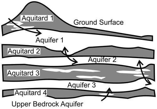
Hydrogeologically, till units generally act as aquitards and outwash sand and gravel deposits as aquifers (Farvolden and Weitzman Citation1980; Terraqua Investigations Ltd. Citation1995; Martin and Frind Citation1998; Blackport et al. Citation2014, this issue). The units are of variable thickness and grain size; some are laterally discontinuous, with numerous hydraulic “windows” present in the aquitards connecting the different aquifers. These “windows” were initially suspected to provide hydrogeological short circuits (Woeller Citation1982; van Everdingen Citation1984). The stratigraphic heterogeneity present in the aquifer structure (Farvolden and Woeller Citation1980; Karrow Citation1993; Bajc and Shirota Citation2007; Bajc et al. Citation2014, this issue), only imperfectly approximated by the simple conceptual model (Figure ), presents significant challenges for identifying fluid flow paths (e.g. Stotler et al. Citation2011; Frind et al. Citation2014, this issue). Later physical hydrogeological studies at specific sites such as the Greenbrook well field (Lotimer Citation1985), hydrogeological modelling (Rudolph and Sudicky Citation1990) and geochemical and isotopic studies (Fritz et al. Citation1991; Stotler et al. Citation2011) confirmed the importance of these stratigraphic openings in the aquitards to both the water supply and the transport of contaminants from source to pumping well. Finally, the geochemistry has been found to be heterogeneous between and within the aquifers, an indication of the complex depositional history of the area and the many interconnections between aquifers (Stotler et al. Citation2011).
Geochemical sampling history
The Waterloo Moraine is an intensively studied water supply aquifer, unique for its extensive and varied groundwater age dataset that spans nearly four decades. Geochemical sampling in the Waterloo Moraine aquifer started in 1976. From the 1970s through the 1980s, geochemical characterizations focused in the immediate vicinity of the major well fields, particularly Greenbrook and Mannheim (Figure ) (Nowicki Citation1976; Fritz et al. Citation1991; Region of Waterloo Citation2012). The first truly regional geochemical studies of the aquifer were performed in the early 1990s (Martyn Citation1991; Johnston Citation1994; Terraqua Investigations Ltd. Citation1992, Citation1995; Johnston et al. Citation1998). These studies were conducted as the Region of Waterloo started to develop a water resource protection strategy in response to groundwater contamination discovered in a municipal well field in the Town of Elmira, north of Waterloo (Blackport Citation2009). The regional study was followed by a monitoring program (Water and Earth Science Associates (WESA) Citation2007, Citation2008; Burnside and Associates Citation2009) focusing on portions of the Moraine where non-point contamination issues were identified by Johnston (Citation1994), Terraqua Investigations Ltd. (Citation1995) and Johnston et al. (Citation1998). These initial regional studies, and the contemporaneous conclusion that the aquifer was fully developed (Terraqua Investigations Ltd. Citation1995), prompted the Region of Waterloo to prioritize groundwater protection. The most recent regional study was conducted in 2001–2002, with subsections sampled again in 2004–2006 (Stotler Citation2003; el Mugammar Citation2006; Stotler et al. Citation2011). Figure shows the locations of a majority of the wells sampled in these various studies.
In the summer of 2000, a large E. coli outbreak in the nearby community of Walkerton, Ontario, and the public inquiry that followed precipitated changes to laws regulating municipal water supplies (O’Connor Citation2002). As a result, the focus of geochemical investigations shifted to identifying the geochemical effects of land use and changes resulting from urbanization, discerning locations of hydraulic windows through aquitards, establishing well field protection areas, identifying municipal groundwater supply wells under the direct influence of surface water and further managing non-point source pollution issues (CH2M Hill Citation2002; Stantec Consulting Ltd. Citation2003, Citation2009; Stotler et al. Citation2005, Citation2011; el Mugammar Citation2006). In response to this, the Region of Waterloo conducts ongoing water quality monitoring as part of source protection activities that are focused at select municipal supply and monitoring wells, a strategy implemented in 1999 (Blackport Citation2009).
Groundwater age as a tool for understanding the flow system
In the Waterloo Moraine aquifer, environmental tracers have provided important information about the age and source of the water produced. Here, investigations over the last forty years have used a variety of groundwater age dating techniques, including 3H, 3H/3He, 4He, 14C, CFCs, and SF6 (Nowicki Citation1976; Fritz et al. Citation1991; Martyn Citation1991; Johnston Citation1994; Johnston et al. Citation1998; Stotler Citation2003; el Mugammar Citation2006; Stotler et al. Citation2011). This established a relatively unique database of relative groundwater ages in the different aquifer units, providing the opportunity to observe changes in water ages and groundwater mixing as long-term withdrawal of potable water draws younger water to the regional well fields. Repeat sampling of these environmental tracers in the Waterloo Moraine aquifer provided the data necessary to investigate several important questions, including: (1) assessing groundwater velocity using radioactive environmental tracers, (2) estimating groundwater age, (3) determining flow path directions and (4) identifying and understanding the evolution of contamination problems (Nowicki Citation1976; Fritz et al. Citation1991, Citation1994; Johnston et al. Citation1998; Stotler et al. Citation2011). These age and geochemical studies can be used to assess the future of inputs from anthropogenic activities, such as road deicing and agricultural practices.
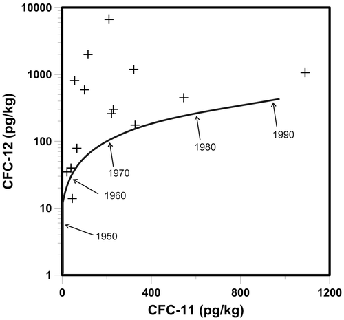
The first field study to address the effects of unsaturated zone transport on CFC and 3H/3He ages, and the first study in North America to document excess CFC concentrations (CFC-12) in both groundwater and the local atmosphere, was conducted on the Waterloo Moraine (Johnston et al. Citation1998). A 30-m-thick unsaturated zone in the assumed recharge area, thinning to 7 m in other areas (Johnston et al. Citation1998; CH2M Hill and S.S. Papadopulos and Associates Citation2003), was estimated to slow CFC transport, supporting an earlier theoretical study (Cook and Solomon Citation1995). The resulting time lag, which is a function of unsaturated zone thickness, tracer solubility in water, soil moisture content and tracer diffusion coefficients (Weeks et al. Citation1982; Cook and Solomon Citation1995), led to CFC-ages that represent the actual time since the water entered the subsurface as precipitation, or the apparent CFC groundwater age.
Determining groundwater age from CFC concentrations was also complicated by CFC-12 concentrations equal to, or higher than, atmospheric solubility (Johnston et al. Citation1998; Figure ). CFC concentrations in groundwater and soil zone in excess of global atmospheric solubility and air entrainment (“excess air”) had previously been observed at a few other sites, where they were attributed to either localized atmospheric CFC contamination, contamination of sampling equipment, or both (Russell and Thompson Citation1983; Oster et al. Citation1996; Szabo et al. Citation1996). Subsequent investigations reviewed pathways that could produce anomalously high groundwater CFC concentrations (Plummer and Busenberg Citation2000; Höhener et al. Citation2003). Such high values typically preclude accurate groundwater age determination using the affected tracer.
Figure 3. Concentrations of CFC-11 vs. CFC-12 measured from groundwater samples collected within the Waterloo Moraine. Solid line represents CFC-11 and CFC-12 concentrations in water based on measured atmospheric concentration and a recharge temperature of 6°C. Most CFC-12 concentrations were much higher than expected (from Johnston et al. Citation1998, with permission).
Groundwater age analyses often use multiple tracers to better constrain results, and investigations with the more precise age tracers in the Waterloo Moraine were no different. To provide a comparison with the CFC data, samples were collected and analyzed for 3H/3He from three wells in 1992 (Johnston et al. Citation1998). Thirteen wells from the original Johnston et al. (Citation1998) study were resampled in 2002–2003 and analyzed for SF6; 10 of those wells were also sampled for 3H/3He analysis (Stotler Citation2003). It is believed that this was the first Canadian field application of the SF6 environmental age tracer; the technique had just been introduced (Busenberg and Plummer Citation2000). Discrepancies were observed between the different tracer-derived groundwater ages in subsequent studies in the same wells (Stotler Citation2003).
Several processes likely resulted in the observed discrepancies between age tracers. First, analysis of multiple age tracers in additional wells in the second study indicated that there was not a single recharge location for the aquifer. Rather, the agreement between uncorrected SF6 ages and 3H/3He ages indicates recharge does occur in some parts of the aquifer with a shallow water table. Using a single unsaturated zone lag correction for CFC-ages may have resulted in over-estimating groundwater age in some areas. In some wells, the 3H/3He age in water sampled in 2002 was approximately 10 years younger than that of SF6 (waters sampled in 2002), CFC (waters sampled in 1994) and, in two instances, the 3H/3He ages (waters sampled in 1994) (Stotler Citation2003). This is indicative of exsolution into air bubbles, possibly due to sampling artifacts, such as unseen air bubbles in the copper sample tubes collected during the second sampling, and/or processes occurring within the aquifer producing gases which might create air bubbles, such as excess air related to a moving water table or exsolution due to N2 air bubbles produced from denitrification (e.g. Blicher-Mathiesen et al. Citation1998; Solomon and Cook Citation2000; Stotler Citation2003).
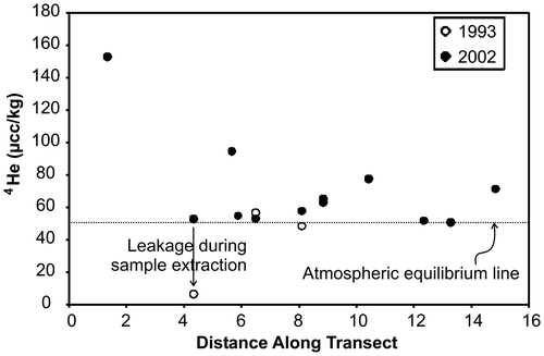
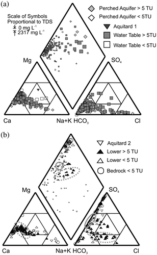
While 3H, 3H/3He, CFCs, SF6 and, to a lesser degree, 14C all provide information about modern recharge to the Waterloo Moraine aquifer, very little information had been collected about the possibility for mixing with older water. Recent work suggests any particular groundwater sample is actually a mixture of groundwater ages (e.g. Bethke and Johnson Citation2002, Citation2008; Cornaton et al. Citation2011; Sanford Citation2011). To study this in the Waterloo Moraine, 4He data were investigated in the same wells where the modern environmental tracers were sampled (Stotler et al. Citation2011). Radiogenic 4He values generally increase with residence time in groundwater provided there are no sources of 4He outside of aquifer materials (Andrews and Lee Citation1979; Solomon Citation2000). Geologically young groundwaters of less than 50 years of age should have relatively similar 4He values near atmospheric equilibrium. Six of 12 samples, located across the N-S central axis of the Waterloo Moraine, had 4He values significantly higher than atmospheric equilibrium, indicating mixing with an older fluid (Figure ). It was suggested this older groundwater component was leaking or diffusing upward from underlying aquitard materials (Stotler et al. Citation2011). This supports evidence from sulphur isotopic studies and geochemical modeling calculations indicating bedrock groundwater components in many of the lower aquifers (Fritz et al. Citation1991; Stotler et al. Citation2011).
Figure 4. Helium-4 (4He) concentrations from wells screened in the upper aquifers. A significant number of samples have higher 4He concentrations than expected, indicating presence of older waters (from Stotler et al. Citation2011, with permission).
Recent advances in groundwater flow modelling of the Waterloo Moraine aquifers have resulted in numerical simulations of groundwater age to determining time of travel to production wells (Molson and Frind Citation2012; Frind et al. Citation2014, this issue). Geochemical data from the Waterloo Moraine aquifer indicate mixing of groundwaters of different ages (Fritz et al. Citation1991; Stotler et al. Citation2011). The next iteration of environmental tracer studies in the Waterloo Moraine will need to combine geochemical and numerical approaches. This will potentially develop a better understanding of how dispersion and mixing are affecting interpretation of geochemically determined groundwater “ages” in complex aquifers. All of this helps elucidate the meaning of the differences between modelled and chemically determined groundwater ages.
Impact of land use on geochemistry
Understanding the effects of urbanization on groundwater supplies is an emerging field of study worldwide (Schirmer et al. Citation2013). The question of what geochemical changes can be expected in moraine aquifers as overlying land is developed is significant in areas such as southern Ontario. Although there are a number of moraines supplying significant quantities of water, growing populations and increasing land values are placing developmental demand on these water supply sources (e.g. Howard et al. Citation1995). In other areas, recent investigations have indicated both neutral and negative effects on groundwater quality as a result of land use intensification (Morgenstern and Daughney Citation2012; White et al. Citation2013). Thus, it is imperative to understand how geochemical conditions in moraine aquifers like these will be affected as urbanization progresses.
Over the nearly four decades of geochemical study, the cities of Kitchener and Waterloo have expanded, with changing land use over significant sections of the Waterloo Moraine. Today, the Waterloo Moraine underlies both urban and rural areas. Only a very small subset of wells was sampled during the actual transition from a rural to an urban setting, and the amount of time for changes to affect aquifer geochemistry was too short to truly identify significant trends (Stotler et al. Citation2005). Despite this, important insights into the differences between urban and rural watersheds can be gleaned through analysis of the extensive datasets collected at two Waterloo Moraine well fields: the Greenbrook and Mannheim well fields (Figure ). Municipal wells in both areas were identified as GUDI-EF wells, or wells under the direct influence of surface water with effective filtration (CH2M Hill Citation2002; Region of Waterloo Citation2012), providing some indication that connections with the surface are relatively similar at both locations. Additionally, the Greenbrook and Mannheim well fields have similar subsurface characteristics, but are located under different land use regimes.
Urban groundwater geochemistry: The Greenbrook well field
The Greenbrook well field (Figure ), although originally located in a rural setting, is now situated within a residential area of the city of Kitchener. The first wells were drilled to bedrock next to the Greenbrook pond in the early 1900s, making this one of the longest continually pumped well fields in southern Ontario. This well field still accounts for a significant part of the Region’s groundwater supply. A historic (now closed) snow dump and a former landfill site are in close proximity, with a 25-year time of travel to capture zones entirely underlying urban portions of the aquifer (e.g. Fritz et al. Citation1991; Frind et al. Citation2002; Molson and Frind Citation2012). This well field has provided over 50 years of data on the effects of land-use changes on groundwater geochemistry.
The major geochemical trends near the Greenbrook well field are summarized in Figure , part of which displays the anionic components bicarbonate, sulphate and chloride. There is a clear mixing trend between water with elevated chloride and tritium, and water with sulphate and no tritium in the Greenbrook area. Sulphate and chloride thus have distinct sources; determining the relationship to the urbanization process will help identify potential issues in other similar aquifers. The lower aquifer at the site is affected by upconing of bedrock groundwaters, a scenario likely unchanged since the well field first opened. This was documented with the first isotopic surveys in the region, by Nowicki (Citation1976). The δ34S-δ18O isotopic signature of sulphate in groundwaters from the K2 and K6 wells strongly resembled the isotopic signature of the sulphate-rich underlying Silurian aged Salina Formation evaporite/carbonate sequence. Later physical hydrogeology studies, such as those by Béland (Citation1977), Farvolden and Weitzman (Citation1980) and Woeller (Citation1982), established four main aquifers and four aquitards underlying the well field and that the surface aquifer had a low potential connection to the deeper system. Lotimer (Citation1985) confirmed this aspect in a later study which addressed the hydraulic connections in this area.
Figure 5. Piper diagram displaying trends in major ion geochemistry within Waterloo Moraine aquifers. (a) Fluids from the perched and water table aquifers; (b) fluids from the lower and bedrock aquifers. In (b), results from wells located in the Greenbrook well field are circled in grey dashed and solid lines (adapted from Stotler et al. Citation2011, with permission).
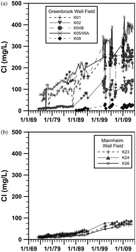
Geochemical studies in the 1970s and 1980s (Nowicki Citation1976; Woeller Citation1982) revealed steadily increasing chloride concentration in the wells of the Greenbrook well field (Figure a), with values in the 1990s rising above the drinking water standard (World Health Organization [WHO] 2003) of 250 mg/L (Bester et al. Citation2006; Stotler et al. Citation2011; Region of Waterloo Citation2012). Significantly higher chloride concentrations approaching 1000 mg/L in shallower monitoring wells, compared with lower values of < 50 mg/L in deeper monitoring wells, indicated an anthropogenic source (Woeller Citation1982; Fritz et al. Citation1991; Stotler et al. Citation2011). Some earlier studies attributed the chloride contamination to the Ottawa Street landfill approximately 1 km to the south, with the Greenbrook wells possibly drawing leachate-contaminated groundwater through “windows” in the aquitards to the well screens (Woeller Citation1982; Rudolph and Sudicky Citation1990; CH2M-Hill Citation1993). A more likely source of the chloride is road salt applied to the roads and streets in the Greenbrook area.
Figure 6. Chloride (Cl) loading with time in (a) Greenbrook well field and (b) Mannheim well field. Data are from Stotler et al. (Citation2011, with permission) and Region of Waterloo (Citation2012).
In Canada, road salt contamination of groundwater was first described in 1972 (Huling and Hollocher Citation1972; McConnell and Lewis Citation1972). In 2001, road salt was declared a toxic environmental contaminant, and in 2004 road salt management plans were required (Canada Gazette Citation2001, Citation2004). The source of elevated chloride concentrations and some elevated sodium concentrations in the Waterloo Moraine aquifer were first identified 1980 as application of salt to roads for deicing (Farvolden and Weitzman Citation1980). More recent studies have clearly identified road salting, common in the region since the 1940s, as the main source of salt contamination, with snow dumps locally at fault (Woeller and Farvolden Citation1989; Fritz et al. Citation1991; Johnston et al. Citation1998; Muhammad Citation2000; Bester et al. Citation2006; Stotler et al. Citation2011). Wells with elevated chloride concentrations also have elevated tritium activity, confirming aquifer salinization is a recent process (Fritz et al. Citation1991; el Mugammar Citation2006; Stotler et al. Citation2011).
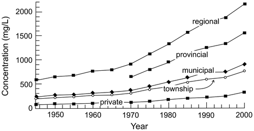
Chloride concentrations have been increasing in the well water at the Greenbrook and Mannheim well fields, with significant concentration variability observed in individual wells (Figure ). Increases are much higher in the Greenbrook urban setting (Figure a), compared to the Mannheim setting which is predominantly rural (Figure b). These increases are consistent with steadily increasing salt loadings for different types of roads (Figure ). Bester et al. (Citation2006) modelled the effects of salt loadings from roadways near the Greenbrook well field and found that the estimated input of up to 3.6 tons per km of road per year could potentially affect the quality of the well water. These authors also investigated various scenarios for reducing the impact and moderating the long-term trend. Based on the results of this study, the Region of Waterloo has developed strategies to stabilize or reduce overall chloride levels in the aquifer, particularly within the 25-year time-of-travel zones around major well fields (Stantec Consulting Ltd. Citation2001, Citation2003; Bester Citation2002; Bester et al. Citation2006; Region of Waterloo Citation2012).
Figure 7. Road salt loading functions for different road types in the Region of Waterloo (from Bester et al. Citation2006, with permission).
Although elevated sodium and chloride concentrations are primarily observed in urban portions of the aquifer, they are also found in wells sampling the perched and water table aquifers along main roads in rural areas. Further, although increased chloride concentrations are all associated with increased sodium concentrations, not all increased sodium concentrations are associated with increased chloride concentrations. The source of these sodium concentrations is unclear; however, it was hypothesized that either (1) dissolved calcium ions are exchanging with sodium ions originally bound to clay-rich sediments in the aquifer or (2) sodium ions are diffusing out of the aquitard (Stotler et al. Citation2011).
Rural groundwater geochemistry: The western Moraine – Mannheim and other locations
The Mannheim West well field is the best example of a highly productive well field impacted by rural practices. This well field is located much closer to the central core of the Moraine, and the stratigraphic units that compose the upper aquifers are much thinner than in the area of the Greenbrook well field. Other well fields in this area, such as Wilmot Centre (see Figure ), are similar in geological and hydrogeological setting and also are affected by rural farming practices.
The well screens for the Mannheim well field are located in what the Region of Waterloo terms Aquifer 1, at depths between 20 and 38 m below ground surface (e.g. Terraqua Investigations Ltd. Citation1995). This is an extensive aquifer, consisting primarily of glacial reworked outwash sands and gravels. The aquifer is semi-confined to unconfined with shallow water tables often within 10 m of the surface (CH2M Hill and S.S. Papadopulos and Associates Citation2003). This area is very important to the Region’s water supply, with ~30% of the Moraine’s sustainable pumping capacity coming from the Mannheim area wells (XCG Consultants Ltd. Citation2007; CH2M Hill Ltd. and North-South Environmental Inc. Citation2008).
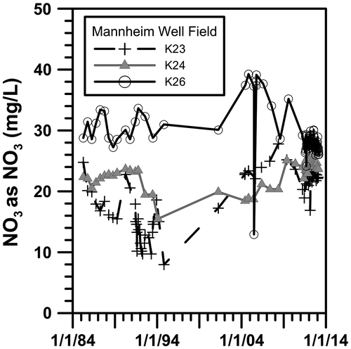
It was not surprising that the first detailed geochemical study in the early 1990s found elevated nitrate concentrations and young waters based on ubiquitous tritium levels in all production wells and many monitoring wells, since the rural well field is located in a hydraulically open system with a high recharge capacity (Johnston et al. Citation1998). That study reported tritium values at 20+ TU at the water table, decreasing with depth. At the time, several nearby rural private wells sampled for tritium were below the detection limits (0.8 TU). The major production wells, K24 and K26, had nitrate concentrations of 16 and 48 mg/L and chloride concentrations of 25 and 20 mg/L respectively (Johnston et al. Citation1998). Ten years later (in 2001–2002 and 2004–2006), many of the same production and monitoring wells were resampled for a wide range of geochemical and isotopic parameters (Stotler Citation2003; el Mugammar Citation2006). As reported in Stotler et al. (Citation2011), of the 39 wells resampled, the nitrate concentrations (reported here as NO3) did not change in 36%, went up in 38% and went down in 26% of the sampled wells.
The Region of Waterloo has monitored many of the production wells in the western part of the Waterloo Moraine area since the mid-1980s for nitrate concentrations, a few of which are displayed in Figure (Region of Waterloo Citation2012). Contamination in the Mannheim West well field (K22A, K23, K24, K26) and other fields in the area not shown in the figure is characterized by a general increase in nitrate concentration, chloride levels that are low compared to areas like the Greenbrook well field, and a lack of anthropogenic organic compounds (Region of Waterloo Citation2012).
Figure 8. Nitrate (NO3) loading with time in the Mannheim well field. Data are from the Region of Waterloo (Citation2012).
Managing non-point source pollution, such as nitrate, to municipal wells is an emerging field in hydrogeology. Current trends include establishing best (or beneficial) management practices (BMPs) for land owners to follow, and public education (Simpson and de Loë, Citation2014, this issue). In the Mannheim area, this has taken a number of forms. Agricultural groups have lowered the amount of nitrogen used from 50 kg N/ha in the 1990s to ~30 kg N/ha in the late 2000s (Stantec Citation2012). The loading of organic manure-based fertilizer has been scaled back in favor of more inorganic based fertilizer; further, farmers are being encouraged to avoid fertilizing fields in the fall (WESA Citation2008, Citation2012). In addition, the removal of certain high impact animal husbandry practices within the well capture zone could lead to an improvement of water quality.
A more direct approach was taken at the now-defunct Baden well field (Figure ). In response to already high nitrate levels and in anticipation of the large mass of nitrate approaching regional water supply wells, an in-situ denitrification nutrient wall was developed near the wells (Gierczak et al. Citation2006, 2007). Ultimately, the wells were disconnected from the Region’s water supply (AECOM Canada Ltd. Citation2011; Region of Waterloo Citation2012).
The length of time required for management changes to have an impact on contaminant loadings in the subsurface will vary depending on a number of factors, including geology, amount of contaminant reductions, and recharge and flow rates. As shown in Figure , several production and monitoring wells are exhibiting downward trends in groundwater nitrate concentrations, indicating a potential positive trend for BMPs. The reduction in surface loading was undoubtedly aided by natural denitrification processes to reduce NO3 concentrations. This process was indicated by an enrichment trend in δ15N-NO3 and δ18O-NO3 (+10‰ to +50 ‰ [AIR], and +2‰ to +14‰ [VSMOW], respectively) and high dissolved N2, SO4, coupled with reduced dissolved O2 and NO3 concentrations (Stotler Citation2003; el Mugammar Citation2006).
Böhlke and Denver (Citation1995) and Johnston et al. (Citation1998), and others since (e.g., McMahon et al. Citation2006, 2008) implemented a strategy of combining groundwater age data with contaminant concentration to better understand the fate of nitrate in the subsurface. Future studies in the Waterloo Moraine will undoubtedly benefit from these data with known surface loading histories since implementation of BMPs to better understand the effectiveness of BMPs. Further, this analysis provides a second perspective on contaminant load arrival times to contrast with various modelling studies.
Conclusions
A large geochemical database for the Waterloo Moraine aquifer system has been collected over the past four decades. Numerous wells were sampled repeatedly over this period, which was useful for exploring the long-term effects of pumping on groundwater age and mixing, and how land use affects aquifer quality. The Waterloo Moraine hosted some of the earliest investigations of environmental CFCs and SF6 in groundwater. These studies improved the understanding of the effect of local atmospheric contamination and how thick unsaturated zones affect groundwater age determinations. Seemingly contradictory groundwater residence times, supported by other geochemical information, indicate waters of different ages are mixing within and between the aquifers. New ideas on the meaning of chemically determined environmental age tracers can be coupled with advanced numerical models and an extensive database stretching back four decades to improve understanding of the complex flow system. This will enable researchers to investigate relationships between chemically determined groundwater age and residence time in complex aquifer systems similar to the Waterloo Moraine.
Urban and rural portions of the aquifer system have distinctly different geochemical challenges. Road salt contamination is the major concern in urban areas. On the other hand, non-point source pollutants, such as nitrate, are more prevalent in rural well fields. Recent efforts to decrease the effects of these pollutants, including implementing best management practices (BMPs), are showing potential for improving water quality. An approach combining groundwater residence time with contaminant concentration and isotopic composition will improve understanding of the fate of nitrate as these BMPs take effect. This will aid in identifying the true effect of BMPs on subsurface concentrations of contaminants.
These results clearly show the impacts of anthropogenic loading due to development and urbanization on previously rural moraine aquifers. For sustainability of the water source, the potential impacts on the municipal water supply should be taken into account when planning new residential developments.
Acknowledgements
The authors appreciate the assistance of the Regional Municipality of Waterloo (RMOW) Hydrogeology and Source Water Section of the Water Services Division. Assistance from, and discussions with, T. Middleton (RMOW), I. Macdonald and T. Svensson of WESA, and Craig Johnston of Stantec are appreciated. Comments from Emil Frind and three anonymous reviewers greatly improved this manuscript. Financial contributions for much of the data collected for this study by the second author come from RMOW and Natural Sciences and Engineering Research Council (NSERC) of Canada. Support was also provided by the Groundwater Geoscience Program, Geological Survey of Canada, Natural Resources Canada. The authors thank publishers John Wiley and Sons and Springer Science + Business Media for permission to re-use published material.
References
- AECOM Canada Ltd. 2011. Baden and New Hamburg water and wastewater master plan update – Master plan report volume 1: Summary report (Final). Technical Report to the Region of Waterloo, Project No: 105507/60116643. http://www.regionofwaterloo.ca/en/aboutTheEnvironment/resources/WMPP-BNH_Final.pdf ( accessed March, 2013).
- Andrews, J. N., and D. J. Lee. 1979. Inert gases in groundwater from the Bunter Sandstone of England as indicators of age and paleoclimate trends. Journal of Hydrology 41: 233–252.
- Bajc, A. F., and P. F. Karrow. 2004. Three-dimensional mapping of Quaternary deposits in the Regional Municipality of Waterloo, southwestern Ontario, Lake to Lake. In GAC-MAC Joint Annual Meeting, 72 p. St. Catherines, ON: Geological Association of Canada/Minerological Association of Canada, FT-7.
- Bajc, A. F., and M. J. Newton. 2007. Mapping the subsurface of Waterloo Region, Ontario, Canada: An improved framework of Quaternary Geology for hydrogeological applications. Journal of Maps 3(1): 219–230.
- Bajc, A. F., H. A. J. Russell, and D. R. Sharpe. 2014. A threedimensional hydrostratigraphic model of the Waterloo Moraine area, southern Ontario, Canada. Canadian Water Resources Journal 39(2) doi: 10.1080/07011784.2014.914794.
- Bajc, A. F., and J. Shirota. 2007. Three-dimensional mapping of surficial deposits in the Regional Municipality of Waterloo, southwestern Ontario. Ontario Geological Survey Report, Ground-water Resources Study 3, 72 p. Sudbury, ON.
- Béland, A. 1977. Management of the Greenbrook well field. M.Sc. thesis, Department of Earth Sciences, University of Waterloo.
- Bester, M. 2002. Numerical simulation of road salt impact at the Greenbrook well field, Kitchener, Ontario. M.Sc. thesis, Department of Earth Sciences, University of Waterloo.
- Bester, M., E. O. Frind, J. W. Molson, and D. L. Rudolph. 2006. Numerical investigation of road salt impact on an urban wellfield. Ground Water 44(2): 165–175.
- Bethke, C. M., and T. M. Johnson. 2002. Paradox of groundwater age. Geology 30(4): 385–388.
- Bethke, C. M., and T. M. Johnson. 2008. Groundwater age and groundwater age dating. Annual Review of Earth and Planetary Sciences 36: 121–152.
- Blackport, R. 2009. Review of the state of knowledge for the Waterloo and Paris/Galt Moraines. Unpublished report prepared for Land and Water Policy Branch, Ontario Ministry of the Environment, Blackport Hydrogeology Inc., Blackport and Associates Ltd., and AquaResource Inc.
- Blackport, R., P. A. Meyer and P. J. Martin. 2014. Toward an understanding of the Waterloo Moraine hydrogeology. Canadian Water Resources Journal 39(2): doi: 10.1080/07011784.2014.914795.
- Blicher-Mathiesen, G., G. W. McCarty, and L. P. Nielsen. 1998. Denitrification and degassing in groundwater estimated from dissolved dinitrogen and argon. Journal of Hydrology 208: 16–24.
- Böhlke, J. K., and J. M. Denver. 1995. Combined use of groundwater dating, chemical, and isotopic analyses to resolve the history and fate of nitrate contamination in two agricultural watersheds, Atlantic coastal plain, Maryland. Water Resources Research 31: 2319–2339.
- Burnside and Associates. 2009. 2008 Annual monitoring report, Wilmot Centre monitoring program, Region of Waterloo – Wilmot Centre. Technical Report to the Region of Waterloo. Waterloo, ON.
- Busenberg, E., and L. N. Plummer. 2000. Dating young groundwater with sulfur hexafluoride: Natural and anthropogenic sources of sulfur hexafluoride. Water Resources Research 36(10): 3011–3030.
- Canada Gazette. 2001. Part 1, Ottawa, December 1. 135(148).
- Canada Gazette. 2004. Part 1, Ottawa, April 3. 138(14).
- CH2M Hill Ltd. 1993. Hydrogeologic investigation of the former Kitchener landfill site. Final interim report, prepared for the Regional Municipality of Waterloo. Waterloo, ON.
- CH2M Hill Ltd. 2002. Hydrogeological study to evaluate the GUDI status of the Mannheim West, Mannheim East and Peaking well fields. Report prepared for the Region of Waterloo. Waterloo, ON.
- CH2M Hill Ltd., and North-South Environmental Inc. 2008. Alder Creek Watershed study and Upper Strasburg Creek subwatershed plan update – Final report. Report prepared for the Grand River Conservation Authority. Waterloo, ON.
- CH2M Hill Ltd., and S.S. Papadopulos and Associates Inc. 2003. Alder Creek groundwater study – Final report. Prepared for the Region of Waterloo. Waterloo, ON.
- Chapman, L. J., and D. F. Putnam. 1984. The physiography of southern Ontario. 3rd ed. Special Volume 2, 270 p. Ontario Geological Survey. Toronto, ON: Ontario Ministry of Natural Resources.
- Cook, P. G., and D. K. Solomon. 1995. Transport of atmospheric trace gases to the water table: Implications for groundwater dating with chlorofluorocarbons and krypton 85. Water Resources Research 31(2): 263–270.
- Cornaton, F. J., Y.-J. Park, and E. Deleersnijder. 2011. On the biases affecting water ages inferred from isotopic data. Journal of Hydrology 410: 217–225.
- el Mugammar, H. 2006. A geochemical and isotope study of the Waterloo Moraine upper aquifer. M.Sc. project report, University of Waterloo.
- Farvolden, R., and M. Weitzman. 1980. Technical report: Greenbrook well field study. Department of Earth Sciences. Waterloo, ON: University of Waterloo.
- Frind, E. O., J. W. Molson, M. R. Sousa, and P. J. Martin. 2014. Insights from four decades of model development on the Waterloo Moraine: A review. Canadian Water Resources Journal 39(2): doi: 10.1080/07011784.2014.914799.
- Frind, E. O., D. S. Muhammad, and J. W. Molson. 2002. Delineation of three-dimensional capture zones in complex multi-aquifer systems. Ground Water 40(6): 586–589.
- Fritz, S. J., R. J. Drimmie, and P. Fritz. 1991. Characterizing shallow aquifers using tritium and 14C: Periodic sampling based on tritium half-life. Applied Geochemistry 6(1): 17–33.
- Fritz, S. J., F. E. Harvey, R. J. Drimmie, C. J. Johnston, and S. K. Frape. 1994. Tritium variability of repeated samplings of well waters in Southern Ontario. Mineralogical Magazine 58A: 292–293.
- Gautrey, S. J. 1996. The hydrostratigraphy of the Waterloo Moraine. M.Sc. project report, University of Waterloo.
- Gierczak, R. F. D., J. F. Devlin, and D. L. Rudolph. 2006. Combined use of field and laboratory testing to predict preferred flow paths in a heterogeneous aquifer. Journal of Contaminant Hydrology 82: 75–98.
- Gierczak, R. F. D., J. F. Devlin, and D. L. Rudolph. 2007. Field test of a cross-injection scheme for stimulating in situ denitrification near a municipal water supply well. Journal of Contaminant Hydrology 89: 48–70.
- Hodgins, E., T. Middleton, D. Corbett, and R. Wootton. 2012. The Waterloo Moraine and Waterloo Region – One of Canada’s leading groundwater management programs. Fieldtrip, 39th International Association of Hydrogeologists Congress, Niagara Falls, ON, September 16.
- Höhener, P., D. Werner, C. Balsiger, and G. Pasteris. 2003. Worldwide occurrence and fate of chlorofluorocarbons in groundwater. Critical Reviews in Environmental Sciences and Technology 33(1): 1–29.
- Howard, K. W. F., N. Eyles, P. J. Smart, J. I. Boyce, R. E. Gerber, S. L. Salvatori, and M. Doughty. 1995. The Oak Ridges Moraine of southern Ontario: A ground-water resource at risk. Geoscience Canada 22(3): 101–120.
- Huling, E., and T. Hollocher. 1972. Groundwater contamination by road salt: Steady-state concentrations in East Central Massachusetts. Science 176: 288–290.
- Johnston, C. T. 1994. Geochemistry, isotopic composition, and age of groundwater from the Waterloo Moraine: Implication for groundwater protection and management. M.Sc. thesis, Department of Earth Sciences, University of Waterloo.
- Johnston, C. T., P. G. Cook, S. K. Frape, L. N. Plummer, E. Busenberg, and R. J. Blackport. 1998. Ground water age and nitrate distribution within a glacial aquifer beneath a thick unsaturated zone. Ground Water 36(1): 171–180.
- Karrow, P. F. 1993. Quaternary geology of the Stratford – Conestogo area. Ontario Geological Survey Report 283. Toronto, ON: Ministry of Northern Development and Mines.
- Lotimer, A. R. 1985. Groundwater flow in a multiple aquifer system at Kitchener, Ontario. MSc thesis, University of Waterloo.
- Martin, P. J., and E. O. Frind. 1998. Modeling a complex multi-aquifer system: the Waterloo Moraine. Ground Water 36: 679–690.
- Martyn, M. M. 1991. Hydrogeochemical study of the Laurel Creek aquifers. B.As. thesis, Geological Engineering, University of Waterloo.
- McConnell, H., and J. Lewis. 1972. Add salt to taste. Environment 14(9): 38.
- McMahon, P. B., J. K. Böhlke, L. J. Kauffman, K. L. Kipp, M. K. Landon, C. A. Crandall, K. R. Burrow, and C. J. Brown. 2008. Source and transport controls on the movement of nitrate to public supply wells in selected principal aquifers of the United States. Water Resources Research 44: W04401. doi:10.1029/2007WR006252.
- McMahon, P. B., K. F. Dennehy, B. W. Bruce, J. K. Böhlke, R. L. Michel, J. J. Gurdak, and D. B. Hurlbut. 2006. Storage and transit time of chemicals in thick unsaturated zones under rangeland and irrigated cropland, High Plains, United States. Water Resources Research 42: W03413. doi:10.1029/2005WR004417.
- Molson, J. W., and E. O. Frind. 2012. On the use of mean groundwater age, life expectancy and capture probability for defining aquifer vulnerability and time-of-travel zones for source water protection. Journal of Contaminant Hydrology 127: 76–87.
- Morgenstern, U., and C. J. Daughney. 2012. Groundwater age for identification of baseline groundwater quality and impacts of land-use intensification: The National Groundwater Monitoring Programme of New Zealand. Journal of Hydrology 456–457: 79–93.
- Muhammad, D. S. 2000. Methodologies for capture zone delineation for the Waterloo Moraine well fields. M.Sc. thesis, Department of Earth Sciences, University of Waterloo.
- Nowicki, V. 1976. An investigation of the Kitchener aquifer system using the stable isotopes 34S and 18O. M.Sc. thesis, Department of Earth Sciences, University of Waterloo.
- O’Connor, D. R. 2002. Report of the Walkerton Inquiry: The events of May 2000 and related issues. Parts 1 and 2. Toronto, ON: Ontario Ministry of the Attorney General.
- Oster, H., C. Sonntag, and K. O. Münnich. 1996. Groundwater age dating with chlorofluorocarbons. Water Resources Research 32(10): 2989–3001.
- Plummer, L. N., and E. Busenberg. 2000. Chlorofluorocarbons. In Environmental tracers in subsurface hydrology, edited by P. Cook, and A.L. Herczeg, 441–478. Boston, MA: Kluwer Academic Publishers.
- Region of Waterloo. 2012. Clean Water Act issues assessment – Revised v. 3, Region of Waterloo. Final Report Prepared by Hydrogeology and Source Water Section, Water Services Division, Regional Municipality of Waterloo. Waterloo, ON.
- Rudolph, D. L., and E. A. Sudicky. 1990. Simulation of groundwater flow in complex multiaquifer systems: Performance of a quasi three-dimensional technique in the steady-state case. Canadian Geotechnical Journal 27(5): 590–600.
- Russell, A. D., and G. M. Thompson. 1983. Mechanisms leading to enrichment of the atmospheric fluorocarbons CCl3F and CCl2F2 in groundwater. Water Resources Research 19: 57–60.
- Sanford, W. 2011. Calibration of models using groundwater age. Hydrogeology Journal 19(1): 13–16.
- Schirmer, M., S. Leschik, and A. Musolff. 2013. Current research in urban hydrogeology: A review. Advances in Water Resources 51: 280–291.
- Simpson, H. C., and R. C. de Loë. 2014. A collaborative approach to groundwater protection: the case of the rural water quality program for Waterloo Region. Canadian Water Resources Journal 39(2): doi: 10.1080/07011784.2014.914789.
- Solomon, D. K. 2000. 4He in Groundwater. In Environmental Tracers in subsurface hydrology, edited by P. Cook, and A.L. Herczeg, 425–438. Boston: Kluwer Academic Publishers.
- Solomon, D. K., and P. G. Cook. 2000. 3H and 3He. In Environmental tracers in subsurface hydrology, edited by P. Cook and A.L. Herczeg, 397–424. Boston: Kluwer Academic Publishers.
- Stantec Consulting Ltd. 2001. Road salt management and chloride reduction study, Phase 1: Road salt management study. Technical Report, Prepared for the Region of Waterloo. Waterloo, ON.
- Stantec Consulting Ltd. 2003. Road salt management and chloride reduction study, Phase 2: Evaluation of chloride reduction options. Technical Report, Prepared for the Region of Waterloo. Waterloo, ON.
- Stantec Consulting Ltd. 2009. Greenbrook well field supplementary GUDI investigation. Draft, Technical Report prepared for Region of Waterloo. Waterloo, ON.
- Stantec Consulting Ltd. 2012. Nitrate management study, Production Well K26. Report prepared for the Regional Municipality of Waterloo. Waterloo, ON.
- Stotler, R. L. 2003. Change in geochemistry, isotope composition, and residence time within the Waterloo Moraine aquifer complex. M.Sc. thesis, Department of Earth Sciences, University of Waterloo.
- Stotler, R. L., S. K. Frape, H. T. el Mugammar, C. Johnston, I. Judd-Henrey, F. E. Harvey, R. Drimmie, and J. P. Jones. 2011. Geochemical heterogeneity in a small, stratigraphically complex moraine aquifer system (Ontario, Canada): Interpretation of flow and recharge using multiple geochemical parameters. Hydrogeology Journal 19: 101–115.
- Stotler, R. L., J. P. Jones, S. K. Frape, R. J. Drimmie, C. T. Johnston, I. Judd-Henrey. 2005. Urbanization of rural watersheds in the region of Waterloo: implications for water quality. In Bringing groundwater quality research to the watershed scale. Proceedings of GQ2004, the 4th International Groundwater Quality Conference, held at Waterloo, Canada, July 2004, International Association of Hydrological Sciences Publ. 297, 29–35.
- Szabo, Z., D. E. Rice, L. N. Plummer, E. Busenberg, S. Drenkard, and P. Schlosser. 1996. Age dating of shallow groundwater with chlorofluorocarbons, tritium/helium 3, and flow path analysis, southern New Jersey coastal plain. Water Resources Research 32(4): 1023–1038.
- Terraqua Investigations Ltd. 1992. Waterloo north aquifer system study. Unpublished Report to the Regional Municipality of Waterloo.
- Terraqua Investigations Ltd. 1995. Study of the hydrogeology of the Waterloo Moraine. Unpublished Report to the Regional Municipality of Waterloo.
- van Everdingen, D. A. 1984. Hydrogeological study of a surficial sand and gravel limit in south Kitchener, Ontario. M.Sc. Project Report, University of Waterloo.
- Water and Earth Science Associates (WESA). 2007. Nitrate monitoring pilot study – Mannheim west-south (K26). Technical Report prepared for the Region of Waterloo. Waterloo, ON.
- Water and Earth Science Associates (WESA). 2008. Mannheim wellfield (K26) nitrate monitoring follow-Up. Technical Report prepared for the Region of Waterloo, File No. W-B6490-00. Waterloo, ON.
- Water and Earth Science Associates (WESA). 2012. Hydrogeological assessment: Wilmot Centre well field. Technical Report prepared for the Region of Waterloo. Waterloo, ON.
- Weaver, L., and E. Arnaud. 2011. Polyphase glacigenic deformation in the Waterloo Moraine, Kitchener, Ontario, Canada. Sedimentary Geology 235(3–4): 292–303.
- Weeks, E. P., D. E. Earp, and G. M. Thompson. 1982. Use of atmospheric fluorocarbons F-11 and F-12 to determine the diffusion parameters of the unsaturated zone in the Southern High Plains of Texas. Water Resources Research 18: 1365–1378.
- White, P., C. L. Ruble, and M. E. Lane. 2013. The effect of changes in land use on nitrate concentration in water supply wells in southern Chester County, Pennsylvania. Environmental Monitoring and Assessment 185(1): 643–651.
- Woeller, R. M. 1982. Greenbrook wellfield management study 1981–1982. MSc thesis, University of Waterloo.
- Woeller, R. M., and R. N. Farvolden. 1989. The past, present and future of ground water development in the tri-cities of Kitchener, Waterloo and Cambridge, Ontario, Canada. In Proceedings of the NWWA FOCUS Conference on the Regional Groundwater Issues, Kitchener, ON.
- World Health Organization (WHO). 2003. Chlorine in drinking-water. Background document for preparation of WHO Guidelines for drinking-water quality. Geneva, World Health Organization.
- XCG Consultants Ltd. 2007. Region of Waterloo water supply strategy update. Final Report, Technical Report prepared for Regional Municipality of Waterloo, XCG File #5-035-34-01. http://www.regionofwaterloo.ca/en/aboutTheEnvironment/resources/RMOW%20water%20supply%20strategy%20main%20report.pdf ( accessed March, 2013).