
Abstract
Urbanization poses a variety of threats to groundwater resources, potentially impacting both the quantity and the quality of water extracted from wells. Agricultural areas also face their own unique types of threats. Threats can depend on scale, and can take on chronic as well as acute forms. The current framework for threat and impact assessment is reviewed with a focus on the Waterloo Moraine, an important water source for the Region of Waterloo, and suggestions are offered for improvement. These include more effective ways of delineating well capture zones with consideration of uncertainty, and the application of the well vulnerability concept, which provides information on the actual impact of a threat and the time frame of the impact, and the consideration of dynamic phenomena that are particularly critical in the case of acute threats. These issues are seen as part of a comprehensive future framework of science-based groundwater governance for Canada. Along with effective threat assessment, the mitigation of impact in urban and agricultural areas is also essential in the sustainable management of groundwater resources.
L’urbanisation présente diverses menaces pour les ressources en eau souterraine et pourrait avoir des effets sur la quantité et la qualité de l’eau extraite des puits. Les régions agricoles sont également confrontées à des menaces qui leur sont propres. Ces menaces peuvent dépendre de l’échelle considérée, et également se présenter sous forme chronique et aiguë. Dans cet article, nous examinons le cadre actuel d’évaluation des menaces et des impacts en mettant l’accent sur la moraine de Waterloo, une importante source d’eau pour la région de Waterloo, et nous présentons des suggestions afin d’améliorer la situation. Il s’agit de délimiter de façon plus efficace les zones de captage des puits en tenant compte de d’incertitude, et d’appliquer le concept de vulnérabilité, qui fournit de l’information au sujet de l’impact potentiel d’une menace, et enfin de prendre en compte la dynamique d’écoulement qui est d’une importance particulièrement cruciale dans le cas des menaces aiguës. Ces points sont perçus comme faisant partie d’un nouveau cadre exhaustif de gouvernance des eaux souterraines basée sur des données scientifiques pour le Canada. En plus de l’évaluation efficace des menaces, l’atténuation d’impact dans les régions urbaines et agricoles est également essentielle à la gestion durable des ressources en eau souterraine.
Introduction
The sustainable management of groundwater resources within areas undergoing urban development is a challenge that water authorities worldwide are confronted with. Urban development brings with it a multitude of threats to both the quantity and quality of the resource. Although the nature of these threats is generally understood, evaluating their impact on public water supplies and ecological systems remains subject to considerable uncertainty. The combined influence of the hydrogeologic setting, current and past land use, and the cumulative dependence on groundwater in a region of interest dictate the vulnerability of the resource to existing and potential threats. For the sake of this current work, focus will be placed on groundwater resources occurring within glacial overburden deposits such as the Waterloo Moraine, which are also found elsewhere in North America and northern Europe.
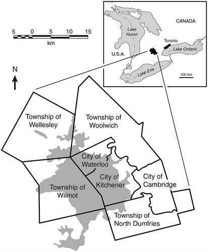
Groundwater within the glacial sediments of the Waterloo Moraine in southern Ontario supports the ecological health of numerous streams and wetlands, while simultaneously providing most of the municipal water to a community of approximately 550,000 inhabitants within the Region of Waterloo (Ontario, Canada), its three cities of Waterloo, Kitchener and Cambridge, and its four townships (Figure ). This Region is currently undergoing intense economic and population growth: its population increased by ~50% between 1976 and 2001 (from ~290,000 to ~440,000), while the number of households increased by ~75% (from ~95,000 to ~160,000) in the same period. The Region ranks as the fourth largest urban area in Ontario and the 10th largest in Canada (Region of Waterloo Citation2005). Growth is expected to continue and even intensify in the near future, as the Region of Waterloo has been designated by the Government of Ontario as a future growth centre. As a consequence, the population is expected to increase to approximately 742,000 by 2031 (Ontario Ministry of Infrastructure Citation2006). This development is expected to significantly increase the stress on the groundwater resources within the Waterloo Moraine. The stress will be due to not only the increasing demand for water, but also the potential decline in groundwater quality and availability as a result of various human activities or natural phenomena, such as droughts and floods. Sustainability in the use of the water source and in the health of ecosystems is therefore an essential objective. To achieve sustainability, it is fundamental to properly identify and manage existent and emerging threats to the groundwater.
Figure 1. Waterloo Region with its three cities and four rural townships, also showing the Waterloo Moraine (shaded grey).
The identification of threats to groundwater resources has been the subject of numerous studies over the last few decades and has formally become part of legislative guidelines in Ontario (Province of Ontario Citation2006). For the purpose of this work, a threat is defined as a condition or activity – past, present or future – that is impacting or has the potential to impact the quality or quantity of a groundwater resource. It is consistent with the term “drinking water threat”, defined by the Ontario Clean Water Act (Province of Ontario Citation2006, Part I:2) as “an activity or condition that adversely affects or has the potential to adversely affect the quality or quantity of any water that is or may be used as a source of drinking water.”
In Ontario, a number of governmental regulations, guidelines and studies exist that are relevant to protection against threats to water resources. These concern land use planning (Province of Ontario Citation1990e, Citation2005; Ontario Ministry of Municipal Affairs and Housing Citation2005; Ontario Ministry of Infrastructure Citation2006), environmental protection (Province of Ontario Citation1990b, Citation1990c), specific activities (Province of Ontario Citation1990a, Citation2002a) and water resource management (Province of Ontario Citation1990d, Citation2002b, Citation2006). Specifically, the Clean Water Act (Province of Ontario Citation2006; Ontario Ministry of the Environment Citation2009a) requires drinking water threats to be identified, followed by the development and implementation of a source-water protection plan. Recognizing that science and technology are ever-changing, and inspired to apply the best management tools available, Ontario guidelines stipulate source-water protection to be science-based and subject to continual improvement (Province of Ontario Citation2006).
An important component of the impact assessment for a specific threat relates to quantifying the vulnerability of aquifers, wells and surface water sources. Vulnerability refers to the potential of a given receptor to be impacted by a specific threat or group of threats. Although many strategies and methodologies have been devised to quantify the vulnerability of a given groundwater supply to a specific set of threats, debate persists regarding the validity and effectiveness of these approaches. One of the greatest threats to the integrity of groundwater resources is the uncertainty associated with the threat assessment process itself, which often depends upon the prioritization and quantification of the impacts of a complex set of interrelated threats to both the quality and quantity of the groundwater resource at hand. This uncertainty is often not considered adequately. The challenges due to uncertainty in translating science to policy for groundwater management are discussed by Blackport and Dorfman (Citation2014, this issue).
This paper first presents a summary of the main existing and emerging threats to groundwater quantity and quality within the Waterloo Moraine, with a focus on conditions encountered within the urban and rural environments of the cities of Kitchener and Waterloo and environs within the Region of Waterloo. A discussion of possible ways to address these threats within the context of long-term groundwater management is presented with reference to historical approaches employed throughout the Waterloo Moraine. Specifically, the issue of the temporal and spatial scale of the different threats and the use of numerical models in threat management are examined. Finally, an evaluation of some of the inherent limitations associated with conventional well capture zone delineation and vulnerability analysis approaches is presented along with suggestions for enhancements to these methodologies. The main objective of this paper is not to provide definite answers or to promote specific techniques, but to contribute to a broader debate aiming to improve how threats to regional groundwater resources are identified, assessed and mitigated, using the Waterloo Moraine system as a case in point.
The Region of Waterloo has been a leader in promoting initiatives for environmental preservation. In 1973, the Region created the first Ecological and Environmental Advisory Committee (EEAC) in Canada, which served as a model for similar initiatives on a national scale (Gosselin Citation2003). Also, the Region has been on the forefront of the implementation of Ontario’s Clean Water Act, serving as an example to other regions. The present state of groundwater protection in the Region is laid down in a comprehensive and detailed Water Resources Protection Plan (Region of Waterloo Citation2008).
Current and emerging threats to groundwater sources in Waterloo Region
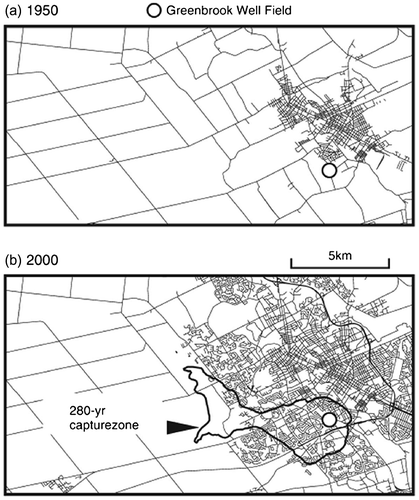
The Waterloo Moraine has been a reliable source of groundwater for municipal and industrial use since the late 1800s, and in fact the availability of ample water of high quality has been one of the key factors in the economic development of the Region. At present, the Region operates an extensive network of approximately 130 municipal supply wells, mostly clustered in well fields within and in the vicinity of the Waterloo Moraine (Figure ) that together provide about 75% of the Region’s water needs. As development began in the late 1800s, wells were initially drilled at the edge of the urban area to be close to the demand, yet outside of the urban footprint. As the population grew, the number of public supply wells increased and the urban area expanded outward, surrounding many of the wells and well fields such that they are now located within the urban area, as in the case of the Greenbrook well field (Figure ). Large-capacity supply wells have also been constructed at greater distances from the urban area in the rural landscape where agricultural land use dominates. As would be expected, wells in the urban area face different threats than those in the rural areas.
Figure 2. Well fields in the Region of Waterloo. Well fields discussed in this paper are labelled.
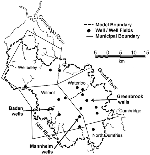
Figure 3. Urban growth in the area of the Greenbrook well field from (a) 1950 to (b) 2000. Figure b also shows the capture zone for the well field obtained from the 280-year capture probability plume (from Bester et al. Citation2006, with permission).
The expansion of urbanization has brought with it an increase in impervious areas in the form of roads, parking lots and roofs, thus decreasing natural infiltration and increasing precipitation runoff. The densely populated urban centres require a dense network of transportation and waste facilities, and host various types of industrial development. Combined with the enhanced surface runoff, this concentration of potentially polluting activities has resulted in an accelerated transfer of a wide spectrum of anthropogenic contaminants to the shallow subsurface and surface water systems, threatening both groundwater and surface water quality. A comprehensive list of threats has been compiled by the Ministry of the Environment of Ontario (Ontario Ministry of the Environment Citation2006), and a simplified list focused on urban and rural areas is given in Table .
Table 1. Threats to drinking water in urban and rural areas (adapted from Ontario Ministry of the Environment Citation2006).
In response to the requirements of the current regulatory framework for Ontario, many independent studies have been commissioned over the last decade to assess threats to groundwater resources within the Waterloo Moraine. Examples are the reports by the Lake Erie Region Source Protection Committee (Citation2008, Citation2012), the Region of Waterloo (Citation2006, Citation2008), the Grand River Conservation Authority (Citation2011), XCG Consultants Ltd. (Citation2007), the Ontario Ministry of the Environment (Citation2009b) and AquaResource Inc. (Citation2009). Although each of these reports is unique in scope, there is a remarkably consistent focus on the influence of legacy impacts from long-term land use activities and the concept of cumulative threats related to multiple contaminant sources and conflicting demands, typical of urbanizing watersheds worldwide.
In terms of quantity, parts of the Waterloo Moraine are currently classified as being under “moderate” or “significant” stress (AquaResource Inc. Citation2009), according to the classification system proposed by the Ontario Ministry of the Environment (Citation2009a). This indicates that the sustainability of the exploited groundwater resources in these regions has been identified as a point of concern and additional development capacity may be limited. In terms of quality, the list of potential threats is long and typical of similar locations in developed countries which combine urban, industrial (past or current) and agricultural activities. The main threats to groundwater quantity and quality within the Waterloo Moraine environment are briefly discussed below to provide context for the subsequent analysis.
Agricultural land use and the rural environment
Agriculture is the dominant land use in the Region of Waterloo as a whole (Planning, Housing and Community Services Citation2006). In the Region’s rural areas, rain-fed crop farming and livestock operations predominate. As is the case in similar settings throughout the world, agriculture represents a significant and documented threat to surface and groundwater quality. Agricultural activities are associated with nitrate and phosphate contamination from excess fertilizer application, waterborne pathogens from livestock operations, on-farm septic beds, biosolids application, deadstock disposal and manure application as fertilizer, and contamination from chemical products such as pesticides, herbicides, etc. (Haygarth and Jarvis Citation2002; Arias-Estévez et al. Citation2008; Cleary et al. Citation2010). Impacts on water quality arise due to both point and non-point sources and are characterized as both chronic pollution issues related to long-term, spatially distributed nutrient leaching, and more acute impacts resulting from rapid runoff events or spills into surface waters and the shallow groundwater system. The main receptors of this type of contamination are surface water bodies and wetlands, and private and public supply wells. Surface water features may undergo eutrophication due to nutrient excess (chronic) or function to concentrate agricultural runoff and transport it to the capture zone of a surface water or groundwater intake (acute). In the case of drinking water wells, leaching of excess nutrients to the groundwater system over large surface areas tends to result in slow increases in nitrate concentrations which are temporally persistent. Where manure is stored and applied to crop land as a soil amendment, occasional rapid releases due to spills or intensive infiltration events may manifest in wells as event-based microbial contamination that is normally acute and short-lived.
Over the last decade, nitrate (NO3–) concentrations have progressively been increasing in a number of the rural public supply wells within the Waterloo Moraine. The wells supplying the town of Baden, Ontario (see Figure ) began to exceed the recommended drinking water limit of 10 mg/L (NO3– as nitrogen [N]) in the early 2000s. This initiated the need to search for new groundwater supplies for the town of Baden, and the testing of methods to remove nitrate from the groundwater system through in situ denitrification (Gierczak et al. Citation2006, Citation2007). Nitrate concentrations have also been rising in several of the other rural public supply wells within the Waterloo Moraine system. Although concentrations have not yet exceeded the drinking water limit, steps are underway to delineate the sources of the excess groundwater nitrate and to propose Beneficial Management Practices (BMPs) to reduce the long-term impact on the groundwater quality (Mussell et al. Citation2011).
The spatial variability and large land area involved in agricultural operations adds to the complexity of understanding the nature of the associated threats to water quality. Practical approaches to managing these threats, as noted above, involve BMPs designed to reduce the chances of excess nutrient or chemical release to the environment at both the farmstead and farm field scales. Although these BMPs are based on sound logic, there is a paucity of evidence available to quantify their effectiveness, especially at the regional scale (Council of Canadian Academies Citation2013). Identifying the land area that is contributing the excess nutrient loading to the subsurface is routinely done through the delineation of well capture zones based on numerical modelling tools. Experience has shown this delineation to be problematic and prone to considerable uncertainty (Sousa et al. Citation2013a). This topic is explored in more detail below.
An additional complication in the case of agricultural impacts on water quality is the inherent time lag associated with regional non-point source contaminants which have been moving within the groundwater systems for decades. A major factor influencing the temporal behavior of these sources is the transport behavior through the unsaturated zone. In order to realistically quantify both the vulnerability of a well or evaluate BMP performance, the role of the unsaturated zone can be crucial yet remains poorly understood and often ignored (Sousa et al. Citation2013b). In these settings, the degradation of water quality in supply wells is often a slow process, with the ultimate impacts being delayed for years to decades. A consequence of this is that any attempts to reduce the source loading through nutrient management strategies also require similar extended time periods before their effect is observed in the wells. In the Waterloo Moraine area, the Region of Waterloo has taken proactive steps, through education and financial incentives, to encourage the adoption of various BMPs on private farms to prevent water quality impacts. Specifically, the Rural Water Quality Program was implemented to help mitigate these threats (Region of Waterloo Citation2008; Simpson and de Loë Citation2014, this issue), and both the update and adoption of various BMPs have been encouraging. Assessing the performance of these BMP strategies remains a major challenge due in part to the long time frames frequently involved and the cumulative nature of the agricultural threats at the broader scale.
The Region of Waterloo is also one of the largest producers of aggregate in southwestern Ontario and the demand for aggregates is expected to increase in the future due to the increasing population (Region of Waterloo Citation2010). Approximately 13% of the Waterloo Moraine (46 km2) could potentially be used for aggregate extraction (Poulin Citation2009) and a large portion of this area covers important recharge zones and drinking water supplies. Aggregate extraction is a serious threat to the groundwater resource because it removes the topsoil, thus reducing the capacity of the soil to act as a filter to contaminants and to store water (Peckenham et al. Citation2009). Aerosol contaminants, spills and runoff into the pits have a direct and rapid connection to the water table in what are often highly permeable sediments, enhancing the potential for groundwater quality impacts. Dewatering systems and local heating of on-site ponds where the water table is exposed may negatively impact nearby streams or supply wells (Langer and Arbogast Citation2003; Peckenham et al. Citation2009; Binstock and Carter-Whitney Citation2011). The many facets of this threat to groundwater quality and quantity within the rural environment remain as yet poorly understood.
Urban development
The urbanized area within the Region of Waterloo boundaries consists essentially of the cities of Waterloo, Kitchener and Cambridge (Figure ). The impact of urbanization on groundwater in general has been the subject of many studies internationally including Howard and Israfilov (Citation2002), Lerner (Citation2002) and Vázquez-Suñé et al. (Citation2005). Although the potential threats to both groundwater quality and quantity are well understood, assessing the magnitude of a specific threat and prioritizing the myriad of potential threats within the complex environment have proven to be extremely challenging (Lerner Citation2002; Schirmer et al. Citation2013). From a water quantity perspective, urbanization is generally considered to result in a reduction of groundwater recharge and an increased potential for flooding due to paving and building construction, reducing natural replenishment of the aquifer system (Hollis Citation1975). This can result in lower groundwater levels and, as a consequence, reduced base flow in streams and water supply operational problems (e.g. higher pumping costs, shallow supply wells may run dry). On the other hand, reduced evapotranspiration tends to increase effective recharge. Recharge may also increase locally due to leaky water and wastewater infrastructure (Lerner Citation1990, Citation2002), and leaking domestic sewer pipes (Held et al. Citation2006) can introduce contaminants into the subsurface.
In the case of the Kitchener-Waterloo area, the main production aquifers are relatively deep, confined to semi-confined glacial sands and gravels overlain by glacial till aquitards. The main recharge for these aquifers is derived from the upland areas associated with the Waterloo Moraine to the west of the cities (Blackport et al. Citation2014, this issue). Although there is likely an impact to local recharge from land use changes within the urban region, one of the most significant threats associated with the urban landscape relates to the potential for enhanced flooding and mobilization of surface sources of contamination due to accelerated runoff from impermeable surfaces. This can lead to acute surface water quality impacts and slow, chronic contamination of the subsurface beneath the urban infrastructure from sources such as road deicing compounds (Bester et al. Citation2006). The threat to groundwater quality within the urban environment is both obvious and logical, considering the density and diversity of the land use practices common within a thriving city. However, predicting the magnitude and the timing of these impacts on the quality of water within public supply well networks remains a challenge at a variety of levels. As has been the case for many urban groundwater supply systems, wells and well fields may be initially located outside of existing urban limits, but as development progressively forces these limits to expand, public supply wells end up being surrounded by housing subdivisions, industry and road networks. This was indeed the case in the Kitchener-Waterloo city area where many of the public supply wells originally placed outside the urban area are now located within the footprint of the cities, as illustrated in Figure for the Greenbrook well field. These urban wells are now exposed to point source threats such as chemical/fuel storage tanks, solid waste disposal sites, salvage and transportation yards, active and abandoned industrial sites and cemeteries (Howard and Israfilov Citation2002). In addition, abandoned and inappropriately decommissioned water wells represent potential vertical pathways through the subsurface and may permit hydraulic circulation between different stratigraphic units resulting in preferential transmission of groundwater contaminants. Non-point contaminant sources including lawn and garden chemicals, golf course turf care (Eitzer and Chevalier Citation1999; Robbins et al. Citation2001; Robbins and Birkenholtz Citation2003), road deicing (Ramakrishna and Viraraghavan Citation2005; Bester et al. Citation2006; Cunningham et al. Citation2008) and leakage from domestic sewer lines (Eiswirth and Hötzl Citation1997; Wakida and Lerner Citation2005; Wolf et al. Citation2012) as noted above also present significant threats to groundwater supplies in the urban setting.
Due to the seasonal variability in the contaminant mass flux and the complexity of the subsurface pathways associated with many of the sources, impacts on supply wells are often delayed for extended periods of time. Consequently, steps taken to reduce these impacts may also take many years to be fully realized. Within the Kitchener-Waterloo groundwater supply system, for example, elevated levels of chloride resulting from the legacy use of road deicers over a 60-year period have been detected in several of the well fields over the last decade or so (Bester et al. Citation2006). Proactive steps were taken by the Cities of Kitchener and Waterloo and the Region of Waterloo in 2008 to reduce the application of these deicers near the impacted water wells by up to 25% (Stone et al. Citation2010). This has resulted in the slow but measureable reduction in chloride concentrations in the shallow groundwater system which will manifest itself in the supply wells in due course, although full impact may take decades to be realized (Bester et al. Citation2006). A second example was the detection in 2005 of 1-4 dioxane in the Greenbrook well field, the Region’s oldest well field, where evidence suggested an old, decommissioned landfill located near the wells as a source of the contamination. This again illustrated the time lag associated with historical point sources of contamination. These wells were taken out of service for several years while water treatment infrastructure was designed and constructed.
In recent years, there have been a plethora of new or emerging contaminants that have been identified as potential risks to groundwater quality. These include nanomaterials, pharmaceuticals, personal care products and caffeine, for example (Colvin Citation2003; Lapworth et al. Citation2012). Addressing these emerging threats is challenging due to their uncertain effects on humans and the environment (Stuart et al. Citation2012) and the difficulty of field characterization (Lapworth et al. Citation2012; Wolf et al. Citation2012). For example, prescription pharmaceuticals were detected in groundwater samples collected downgradient of septic tanks in southern Ontario (Carrarra et al. Citation2008), and in surface water samples collected in an urban area at the edge of the Waterloo Moraine (Lissemore et al. Citation2006). Artificial sweeteners such as acesulfame were detected in a 15-year-old plume downgradient of a septic system in southern Ontario (Robertson et al. Citation2012), as well as in water samples collected in the Grand River (Spoelstra et al. Citation2013). Some of these compounds are persistent and can be used as tracers to identify areas impacted by domestic wastewater.
Considering the number and complexity of potential sources threatening groundwater quality, assessing the potential for impact from a specific source and the cumulative influence of multiple sources on a given well presents a significant challenge. Sources can vary in age, contaminant type and attenuation characteristics, mass release flux and geographic position – all factors that influence the potential impact on a well. Also, as explained by Einarson and MacKay (Citation2001), the impact of a contaminant on the quality of well water also depends on the capacity of the well, because a larger well will tend to dilute the contamination by drawing both contaminated water and clean water at the same time.
The approach conventionally employed to identify and prioritize threats present in the vicinity of a given well is to delineate a wellhead protection area (WHPA) through the use of a mathematical simulator, and inventory and characterize each potential source of contamination within the WHPA. In order to identify degradation in water quality and to predict the potential cumulative impact, water quality trends in supply wells and monitoring wells are tracked and contaminant transport models are developed utilizing available data. Some limitations of these conventional approaches and potential improvements in threat assessment methodologies are discussed in a subsequent section.
Climate change
Water resources will likely be impacted by climate change, as predicted by climate scientists (Intergovernmental Panel on Climate Change Citation2007). The nature of these impacts, however, remains difficult to quantify in terms of the actual threat posed to the groundwater resource. Society in general and water managers in particular should prepare to adapt to the expected changes, some of which appear to be manifesting themselves already in the form of extreme weather events. Within the Grand River watershed, for example, where the Waterloo Moraine is located, droughts and intense precipitation events leading to flooding are expected to be more frequent and severe. The average precipitation, event intensity and runoff are expected to increase, whereas winters are predicted to be shorter and warmer with diminished spring melt events. As a consequence, the magnitude, seasonal variability and distribution of groundwater recharge are also predicted to change over the next few decades, influencing groundwater availability and quality (Jyrkama and Sykes Citation2007; EBNFLO Environmental and AquaResource Inc. Citation2010; Council of Canadian Academies Citation2013).
The increased variability in the hydrologic cycle as a result of climate change will also exacerbate the uncertainty associated with recharge estimation. In terms of groundwater quality, the increasing frequency of more intense precipitation events along with mid-winter melt events may result in more frequent rapid infiltration events, accelerating the direct hydraulic connections between land surface and a receptor, such as a pumping well, thereby increasing the risk of contamination, particularly by waterborne pathogens (Cey and Rudolph Citation2009). In order to enhance the utility of groundwater threat assessment strategies, the influence of dynamic recharge phenomena must be considered. Although there are some studies that discuss the importance of dynamic recharge (Sacks et al. Citation1992; Winter Citation1999; Jyrkama et al. Citation2002), this is currently not within standard practice.
Improving the threat assessment framework
Conceptually, the current framework for groundwater threat assessment and management is intuitive and approached through the use of several analytical tools. Potential and existing threats are identified and characterized to the extent possible. The vulnerability of elements to be protected (i.e. aquifers, supply wells, water intakes) is often evaluated through an indexing approach that considers the specific contaminant(s) associated with the source and the nature of the pathway between source and receptor (Van Stempvoort et al. Citation1993). These results are combined to orient monitoring efforts, prioritize threats and assist in predicting potential impacts and in planning future land use management activities and optimize mitigation efforts. This methodology has been used extensively throughout Canada and within the Waterloo Moraine and has provided valuable insight to water authorities.
An approach that is becoming the norm in threats assessment and mitigation is the application of various mathematical modelling tools. Groundwater flow systems are simulated at both the local and regional scales with the intention of delineating the land area contributing recharge water to public supply wells and providing insight into the potential impacts of various contaminant sources existing within that contributing area. Models are also used to assess the relative importance of various parameters and processes that control contaminant fate and mobility in the subsurface (e.g. Frey et al. Citation2012). This can assist in prioritizing the risk of various existing threats, focusing field data collection and evaluating alternative mitigation strategies (e.g. Frind et al. Citation2006). Although the application of groundwater models to the Waterloo Moraine is already discussed in another article in this issue (Frind et al. Citation2014, this issue), some specific points regarding threat management are worth mentioning here.
As pointed out by EBNFLO Environmental and AquaResource Inc. (Citation2010), one of the implications of climate change is that the reliability of historical hydrological records for planning purposes is diminished. Scenario analysis by means of mathematical models can be useful for assessing chronic and acute threats due to climate change, a topic which is emerging as a major factor in threat assessment. In addition, the distinction between point and non-point source threats has important implications from a modelling perspective. Because the key controlling processes may vary with scale, the same well field or aquifer may require different (conceptual) models for assessing these different types of threats. As a consequence, field data and monitoring setup have to be consistent with the specific situation. For example, the assumption of steady-state flow is more appropriate for assessing chronic threats related to non-point source impacts because the time scale of interest spans many hydrological cycles and seasonal variations are dampened. On the other hand, for more local point sources, transient simulations are expected to be more appropriate and specific processes, such as preferential flow, may play a more prominent role.
Accordingly, in order to address these issues, future improvements of the threat assessment process should focus on (1) how to assess and mitigate existent and emerging threats, (2) how to evaluate vulnerability and (3) how to incorporate this knowledge into future planning. An exhaustive discussion of these issues is beyond the scope of this paper. However, some general thoughts on possible ways to improve threat assessment and mitigation, along with some illustrative examples, are presented below.
Wellhead protection areas and well vulnerability
One of the fundamental components of the standard threats assessment framework for groundwater sources is the WHPA (US Environmental Protection Agency Citation1987). The WHPA can be identical to, or a part of, the well capture zone, which is the land area associated with a well that contributes recharge and potential contaminant mass that will ultimately be captured by the well. The WHPA defines the land area to which the wellhead protection strategy applies. The standard procedure for delineating the WHPA is to determine the capture zone by means of regional-scale numerical modelling based on average annual steady-state groundwater flow conditions, and to apply particle tracking methods (e.g. Pollock Citation1994; Frind and Molson Citation2004) to estimate advective travel times to the well. Uncertainties in the hydrogeologic parameters (parametric uncertainties) can be represented by running a Monte Carlo analysis where a large number of realizations of the flow system are generated and the corresponding particle tracks are combined into a capture zone under uncertainty (see for example Meyer et al. Citation2014, this issue). An alternative is to represent the uncertain variations by means of a dispersion parameter (Gelhar and Axness Citation1983) and run a standard advective-dispersive transport model in backward mode to obtain a capture probability plume (Frind et al. Citation2002). A capture zone can then be extracted from the capture probability plume by selecting an appropriate probability contour. As an example, Figure b shows the resulting capture zone extracted from the 280-year capture probability plume for the Greenbrook well field (for location see Figure ). This approach does not consider the influence of seasonal hydrologic variability on the capture zone.
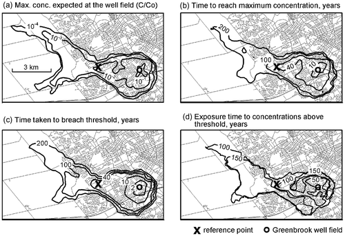
The WHPA obtained by these approaches delineates the area affected by a well, but it does not show the actual impact of a contaminant source on the well. This limitation can be addressed by using the well vulnerability approach (Frind et al. Citation2006), which uses a backward-in-time transport scheme applied to a pulse to predict maximum concentrations expected at the well, the corresponding arrival time, the arrival of critical concentrations and the time period of exposure to concentrations above a critical level. As an example, Figure shows the corresponding well vulnerability maps for the Greenbrook well field (from Frind et al. Citation2006). As this approach incorporates advective and dispersive transport behavior and permits the inclusion of attenuation processes, the information derived from the well vulnerability approach provides more information to the water manager than is possible from capture zone delineation alone.
Figure 4. Well vulnerability maps for the Greenbrook well field: (a) maximum relative concentration (C/C0) expected at the well field due to a potential source (reference point X) within the capture zone, (b) time taken to reach maximum concentration at the well field, (c) time taken to breach threshold value of 10−4 relative to source concentration, (d) exposure time to concentrations above threshold value. Map values at X are values expected at well for source at X (from Frind et al. Citation2006, with permission).
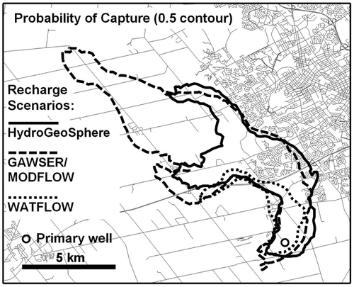
In addition to the parametric uncertainties discussed above, conceptual (or large-scale) uncertainties can also play an important role. These are uncertainties in the conceptual model, for example the presence/absence of aquitard windows, the model boundary conditions or the distribution of the recharge. These uncertainties can be evaluated by means of scenario analysis using a limited number of conceptual models, and merging the resulting capture zones. For example, Sousa et al. (Citation2013a) executed a flow model for the Mannheim well field (for location see Figure ), under three different boundary scenarios defined in terms of the spatial distributions of recharge, with the boundary scenarios generated by three different models operating externally to the primary flow model (Sousa et al. Citation2013a). The result, in the form of the capture zone for one of the wells, showed three dramatically different well capture zones, each being equally plausible (Figure ). The authors demonstrated how these different capture zones can be merged while quantifying the inherent uncertainty, thus producing a defensible outcome. This example demonstrates that conceptual uncertainties such as different recharge scenarios can have a dominating influence on capture zone and WHPA delineation, and it shows how these uncertainties can be managed.
Figure 5. Simulated well capture zones for a municipal well within the Mannheim well field, Region of Waterloo. Capture zones correspond to three different boundary scenarios in terms of the spatial distribution of recharge, generated by the models HydroGeoSphere, GAWSER/MODFLOW and WATFLOW, respectively (adapted from Sousa et al. Citation2013a).
The issue of scale: Chronic vs. acute threats
Potential for improving the threat assessment framework lies also in explicitly categorizing different threats based on the temporal and spatial scales in which they manifest. For the sake of these arguments, threats to groundwater quality will be the focus. Although space and time scales vary over a continuum (Skøien et al. Citation2003), threats can be generally characterized in two main categories: chronic and acute, as discussed earlier related to specific regional settings. Chronic threats develop over a long period of time and a wider spatial scale, affecting groundwater receptors, such as supply wells and streams, over longer pathways/travel times of the subsurface hydrological cycle (e.g. time scale of years, decades or longer). In an urban setting, contamination due to the long-term application of deicing agents (i.e. road salt) or, in the rural environment, elevated nitrate concentrations due to the leaching of excess fertilizer, are examples of chronic threats to groundwater quality. Both sources cover large spatial areas and may take many years to manifest and, consequently, to mitigate (e.g. Fenton et al. Citation2011). Acute threats, on the other hand, happen over a shorter time and spatial scale and are usually restricted to areas surrounding water wells or upper aquifer units. These threats affect groundwater receptors through shorter/faster pathways within the subsurface component of the hydrological cycle (e.g. time scale of days, months) and are usually associated with natural or artificial fluctuations of events that affect sources of contamination (e.g. accidental contaminant spills) and hydrological drivers (e.g. dry seasons, melt events, intense precipitation). An example of an acute water quality threat is the contamination of shallow or poorly constructed wells by waterborne pathogens, usually following intense precipitation or snowmelt events. In these cases, rapid and often locally focused recharge occurs over a relatively short time frame, potentially transmitting contamination through the vadose zone and across the water table. An example of this scenario occurred in Walkerton, Ontario in 2000 (O’Connor Citation2002), where groundwater contaminated by cattle manure affected more than 2300 people, with seven fatalities. In that tragic event, travel time between source and well was exceptionally rapid due to a major spring precipitation event when the shallow subsurface was wet, causing contaminants to reach the well within a few days (Auld et al. Citation2004; Hrudey and Hrudey Citation2004).
Considering the inherent differences between the conditions leading to a chronic threat and those associated with an acute threat, employing distinct threat assessment strategies can be beneficial. The dominant processes that influence the nature of a specific threat in the natural system and our ability to represent these processes in order to characterize the threat are dependent upon the spatial and temporal scale. For example, macropores represented by desiccation cracks, worm/insect burrows and root holes can create rapid, preferential pathways for precipitation water to quickly infiltrate, bypassing the uppermost layers of soil (Cey and Rudolph Citation2009; Frey and Rudolph Citation2011). These features may reduce the capacity of the soil to retain and filter contaminants. Following a precipitation event, these macropores may play an important role in the short-term transport of waterborne pathogens to the shallow subsurface (time scale ~ days) and receptors of concern in that setting. However, they may have a negligible effect on the long-term travel time (time scale ~ years) between a surface source of contamination and a public supply well. In this case, the temporal/spatial scales of the threat will dictate whether to consider macropore flow when assessing the vulnerability of a given supply well to contamination from the source under consideration. The identification of the scale of the problem, therefore, will help to properly identify, characterize, monitor and mitigate threats to groundwater quality more effectively, meaning that for the same groundwater receptor, distinct approaches for chronic and acute threats may be required. A similar argument could be developed to illustrate the importance of an extreme infiltration event in controlling an acute, event-based threat and the reduced impact it would likely have on the chronic threat.
The scale distinction addresses one of the challenges of groundwater management in a pragmatic and sustainable way. For the resource to be properly managed to ensure sustainability for human use and ecosystem functions, both the acute impacts associated with short-term natural and artificial fluctuations and the longer-term, chronic impacts must be considered. This classification approach can be applied to non-point sources (e.g. agricultural land use) and point sources (e.g. landfills), for both groundwater quality and quantity assessments, for existent and emerging threats and, finally, for temporary and permanent threats, which is another important distinction for threat management. In summary, from a source water protection perspective, a public supply well or any other water supply can be considered safe if it is simultaneously protected against both chronic and acute threats, both of which may require distinct consideration.
Threats and impact assessment within the Waterloo Moraine
With the distinction between acute and chronic threats in mind, some comments can be made about the assessment of groundwater threats and impacts in the Waterloo Moraine area. The assessment of chronic threats depends on the installation and maintenance of monitoring systems to collect and interpret long-term data. As a result of extensive previous studies conducted within the Waterloo Moraine area, as exemplified by other articles in this Special Issue, water managers in the Region of Waterloo are in a privileged position in terms of data availability. For example, geochemical analysis of data collected from the extensive monitoring well network in both the rural and urban regions of the Waterloo Moraine (Stotler et al. Citation2014, this issue) can be used to identify the manifestation of chronic impacts potentially far enough in advance to be able to take mitigation measures, plan for treatment options or to look for an alternative source. These analyses in concert with modelling studies can provide guidance to water authorities for appropriate action to reduce the impact of the chronic threat.
In contrast to regularly spaced snapshots and longer sampling intervals for monitoring chronic threats, monitoring systems for acute threats require data collection at a much higher frequency, often in response to intense precipitation or snowmelt events. An example is the case of threats associated with waterborne pathogens, which represent a potential acute threat to groundwater quality, specifically where there is a risk for rapid hydraulic connection between well screens and surface water (i.e. runoff or surface water bodies). Conventional sampling may not represent critical conditions of operation, for example in response to an extreme infiltration event. More specific temporal monitoring may be required. These more intense sampling campaigns may be relatively short (limited to the event and its response) and would require sensor networks that can be automatically triggered to increase sampling frequency based on changes of environmental or hydraulic parameters. This type of automated sampling, little used in the past, offers considerable potential. An example where the resulting focused datasets may assist in evaluating acute threats to groundwater quality is through the evaluation of Ground Water Under the Direct Influence of Surface Water (GUDI), as defined by the Province of Ontario (Province of Ontario Citation2002b).
A major source of uncertainty is recharge, which is the hydrologic driver between the sources of contamination, usually located near or at ground surface, and groundwater receptors (i.e. wells and streams). It is the mechanism by which aquifers are replenished, and quantifying recharge is therefore essential for evaluating the sustainability of groundwater supplies. Understanding the spatial distribution of recharge can indicate locations that need to be protected to ensure water quality and quantity to support human activities and healthy ecosystems. Understanding its temporal distribution is important for understanding the dynamics of infiltration and the risks associated with intense precipitation events. Both chronic and acute threats are influenced by the spatial and temporal characterization of groundwater recharge. Climate change is expected to increase runoff and alter recharge patterns, with potentially harmful impacts on groundwater quality. Recharge is a fundamental parameter in any threat assessment – yet the data on recharge are generally scarce. In hydrogeologic practice, recharge estimations are often based on mathematical models, but, as shown above, the results are affected by model non-uniqueness that can introduce considerable uncertainty into the analysis (Sousa et al. Citation2013a). Therefore, independent field estimations of recharge should always be an integral part of source water protection studies. Many alternatives for recharge estimation are available, as summarized by Scanlon et al. (Citation2002).
Towards a framework for groundwater governance in Canada
Incorporating improvements in the current framework is not a straightforward process. Although the current guidelines encourage continuously improving source water protection techniques (Province of Ontario Citation2006), modifying rules and guidelines is very costly, and it creates resistance from parties facing potentially more stringent restrictions or changes in the way they have become accustomed to respond to regulations. One of the most significant impediments to considering and adopting new approaches is the lack of transparent demonstrations of their effectiveness, value and economic impact. Because of these difficulties, water resource managers and decision makers understandably tend to set aside suggestions for improvement, especially if they are perceived to be costly or complicated. Suggested improvements are then often limited to academic studies, which may not provide an overall assessment of the socio-economic implications of an emerging technology or approach, focusing primarily on the science-based evidence of their functionality. This challenge is not exclusive to water management, and it is an important issue in the interface between science and policy also in other fields.
A suggestion that is within reach of water managers is to commission studies to simulate the application of proposed improvements in one or more locations, as a “pilot scale” test. A critical component of this type of study would be the inclusion of various stakeholders and disciplines whose interests and expertise include the major issues that would influence the acceptance of a modification to existing protocols. This might include economists, planners, municipal water managers and industrial authorities. Practical pilot applications of alternative groundwater threat and vulnerability assessment approaches at an actual field site would provide an opportunity to demonstrate costs and technical benefits, which could be directly compared to those derived through existing methodologies.
Waterloo Region has a successful record of developing science-based policy for the management and protection of its groundwater resources (Blackport and Dorfman Citation2014, this issue). A collaborative approach for groundwater management in the rural areas of Waterloo Region has also been successful (Simpson and de Loë Citation2014, this issue). On a larger scale, discussions on the role of science in policy development, and on collaborative approaches, would be desirable. The experience of Waterloo Region could serve as a basis for such discussions, and as a blueprint for an emerging framework of groundwater governance in Canada.
Impact mitigation
In the presence of continuing urbanization, developing strategies for the mitigation of expected impacts will be an essential tool for maintaining the sustainability of the groundwater resource. Mitigation is here understood to encompass both the prevention of further negative impacts and interventions to actively remedy existing impacts, both with respect to water quantity and water quality. The following is not intended to be an exhaustive treatment of this complex topic.
A logical approach to the mitigation of the impact of urbanization is Low Impact Development (LID), which essentially consists of a variety of engineering and planning measures to minimize the urbanization impacts on the hydrological cycle. Some examples of LID are infiltrating roof runoff, using paving materials that promote infiltration, and directing flow to vegetated areas (Prince George’s County Citation1999). LID techniques target water quantity and quality as well as chronic and acute threats, and involve a variety of aspects, such as erosion and sediment control, storm water pond design and rainwater harvesting. Although the concept of LID is not new, there are still some uncertainties regarding its effectiveness (Gilroy and McCuen Citation2009). Also, the application of LID in cold climates presents some particular challenges that are not yet well understood (Denich and Bradford Citation2008).
An example of the LID approach on the Waterloo Moraine is the functional drainage study (Stantec Consulting Citation2009) for one of the subcatchments of the Grand River watershed, which is being considered for residential development, and which is also a recharge area for the Waterloo Moraine aquifers. The study proposes a combination of engineering measures designed to maintain natural infiltration rates, to mitigate increases in flood flows, and in general to maintain pre-development conditions for groundwater and surface water flows, as far as possible. Among a number of measures such as recharge trenches, wetlands and infiltration trenches designed to enhance recharge, a key component of this system is the clean water collection (CWC) system which collects clean roof runoff and directs it to designated infiltration basins via a pipe network, also known as a “third pipe” (i.e. in addition to water supply and sewer pipes) system. The system is to be monitored before, during and after construction, and regular maintenance will be required. Whether the proposed measures will be effective as intended over the long term of decades remains to be seen.
An adaptive approach to mitigate potential impacts of development on the Waterloo Moraine is discussed by Veale et al. (Citation2014, this issue). This approach considers the watershed as a whole, and it integrates science, management and decision making into a continuous learning cycle that aims to minimize the impact of urban development on the resource and the ecosystem. This approach holds considerable promise, particularly in combination with public education.
The use of beneficial management practices (BMPs) to reduce chronic contamination by non-point source pollutants is another important threat mitigation strategy for the Waterloo Moraine, as well as elsewhere. Recent studies have estimated the potential effects of agricultural BMPs (i.e. strategies to optimize plant uptake and minimize pollution) on nitrate concentrations in impacted supply wells. Results suggest that BMPs can be effective in maintaining concentrations below the drinking water limit (Mussell et al. Citation2011). A similar approach can be taken for road salt (Bester et al. Citation2006; Stone et al. Citation2010). Recent research on the application of BMPs in glacial aquifers in southern Ontario (Sousa Citation2013) indicates that effects may be delayed by legacy contamination and slow travel times in the subsurface. Although in some cases, engineered remediation strategies targeted at high mass flux zones in the aquifer can accelerate improvements (Gierczak et al. Citation2006, Citation2007), a slow system response typical of chronic threats must be expected.
To reduce the acute risk of waterborne pathogens reaching water supply wells during extreme events, a system similar to the previously discussed automated sampling (i.e. triggered by environmental or hydraulic changes) can be considered. For example, some particular wells can be automatically turned off or have pumping rates reduced during precipitation or snowmelt events to temporarily reduce downward hydraulic gradients during extreme events. The same system can increase alert and monitoring frequency in water treatment stations.
Conclusions
The groundwater resource of the Waterloo Moraine faces a variety of threats, both existing and emerging, that can potentially impact the quantity and quality of the water supply for the Region of Waterloo. In the agricultural areas of the Region, chronic threats are nitrate concentrations that continue to increase, while acute threats can occur in the form of agricultural runoff carrying microbial contaminants. Another threat is aggregate extraction, which removes the protective cover from aquifers. In the urban area, threats are due to increasing urbanization that results in the loss of pervious surface area, potentially reducing infiltration and increasing storm runoff, as well as the chronic threat of chloride from the application of road salt. Emerging threats such as pharmaceuticals and artificial sweeteners have also been identified in the sewage effluent; these may find their way into groundwater and surface water. In addition, there is the added potential threat due to climate change, which will probably bring more extreme weather events to which urban systems may be especially vulnerable.
In the face of these threats, an effective threat assessment framework is essential. Improvements in the current framework are possible in the assessment of existent and emerging threats and in knowledge management within the context of future planning. In the delineation of wellhead protection areas, the recognition of uncertainties is particularly important, as some types of uncertainties may dramatically affect the extent of a wellhead protection area. Another improvement is the use of the well vulnerability concept. Effective threat assessment must distinguish between chronic and acute threats, and a consideration of dynamic recharge phenomena is particularly important in the case of acute threats. Addressing these issues should be part of a comprehensive framework of science-based groundwater governance for Canada.
Along with an effective and comprehensive threat assessment, measures to mitigate expected impacts on the groundwater resource are essential. In urban areas, these measures will include low-impact development that can potentially enhance infiltration and reduce storm runoff in new residential developments. In agricultural areas, chronic threats to well water due to excess nitrate application can be reduced by BMPs. An adaptive approach to mitigation based on the entire watershed and integrating science, management and decision making into a continuous learning cycle can help to meet challenges due to the pressures of growth.
Acknowledgements
This research was supported by the Groundwater Geoscience Program, Geological Survey of Canada, Natural Resources Canada. The authors thank the National Ground Water Association and Elsevier Publishers for permission to re-use published material. We thank the reviewers and the Editor for constructive comments that helped to improve the paper. Thanks are also due to Tracy Barry and Michael Frind for help with the graphics.
Related Research Data
References
- AquaResource Inc. 2009. Tier 2 water quantity stress assessment report – Grand River Watershed. Final Report – December 2009. AquaResource Inc. http://www.sourcewater.ca/swp_watersheds_grand/Grand_2009Stress_Final.pdf ( accessed June, 2014).
- Arias-Estévez, M., E. López-Periago, E. Martínez-Carballo, J. Simal-Gándara, J. C. Mejuto, and L. García-Río. 2008. The mobility and degradation of pesticides in soils and the pollution of groundwater resources. Agriculture, Ecosystems and Environment 123(4): 247–260.
- Auld, H., D. MacIver, and J. Klaassen. 2004. Heavy rainfall and waterborne disease outbreaks: The Walkerton example. Journal of Toxicology and Environmental Health, Part A 67(20–22): 1879–1887.
- Bester, M. L., E. O. Frind, J. W. Molson, and D. L. Rudolph. 2006. Numerical investigation of road salt impact on an urban wellfield. Ground Water 44(2): 165–175.
- Binstock, M., and M. Carter-Whitney. 2011. Aggregate extraction in Ontario: A strategy for the future. March 2011. Canadian Institute for Environmental Law and Policy. http://cielap.org/pdf/AggregatesStrategyOntario.pdf ( accessed June, 2014).
- Blackport, R. J., and M. L. Dorfman. 2014. Developing science-based policy for protecting the Waterloo Moraine groundwater resource. Canadian Water Resources Journal 39(2): doi: 10.1080/07011784.2014.914803.
- Blackport, R. J., P. A. Meyer, and P. J. Martin. 2014. Toward an understanding of the Waterloo Moraine hydrogeology. Canadian Water Resources Journal 39(2): doi: 10.1080/07011784.2014.914795.
- Carrara, C., C. J. Ptacek, W. D. Robertson, D. W. Blowes, M. C. Moncur, E. Sverko, and S. Backus. 2008. Fate of pharmaceutical and trace organic compounds in three septic system plumes, Ontario, Canada. Environmental Science and Technology 42(8): 2805–2811.
- Cey, E. E., and D. L. Rudolph. 2009. Field study of macropore flow processes using tension infiltration of a dye tracer in partially saturated soils. Hydrological Processes 23(12): 1768–1779.
- Cleary, B. A., R. J. Gordon, R. C. Jamieson, and C. B. Lake. 2010. Waste management of typical livestock mortalities in Canada: An overview of regulations and guidelines. Canadian Biosystems Engineering 52(6): 11–18.
- Colvin, V. L. 2003. The potential environmental impact of engineered nanomaterials. Nature Biotechnology 21(10): 1166–1170.
- Council of Canadian Academies (CCA). 2013. Water and agriculture in Canada: Towards sustainable management of water resources. Expert Panel on Sustainable Management of Water in Agricultural Landscapes of Canada. Ottawa: Council of Canadian Academies.
- Cunningham, M. A., E. Snyder, D. Yonkin, M. Ross, and T. Elsen. 2008. Accumulation of deicing salts in soils in an urban environment. Urban Ecosystems 11(1): 17–31.
- Denich, C., and A. Bradford. 2008. Cold climate issues for bioretention: Assessing impacts of salt and aggregate application on plant health, media clogging, and groundwater quality. In Low impact development for urban ecosystem and habitat protection, edited by She, N. and M. Char, 1–10. Seattle, WA: American Society of Civil Engineers. doi: 10.1061/41009(333)3.
- EBNFLO Environmental and AquaResource Inc. 2010. Guide for assessment of hydrologic effects of climate change in Ontario. Prepared for the Ontario Ministry of Natural Resources and Ministry of the Environment in partnership with Credit Valley Conservation.
- Einarson, M. D., and D. M. Mackay. 2001. Predicting impacts of groundwater contamination. Environmental Science and Technology 35(3): 66–73.
- Eiswirth, M., and H. Hötzl. 1997. The impact of leaking sewers on urban groundwater. Groundwater in the Urban Environment 1: 399–404.
- Eitzer, B. D., and A. Chevalier. 1999. Landscape care pesticide residues in residential drinking water wells. Bulletin of Environmental Contamination and Toxicology 62(4): 420–427.
- Fenton, O., R. P. O. Schulte, P. Jordan, S. T. J. Lalor, and K. G. Richards. 2011. Time lag: A methodology for the estimation of vertical and horizontal travel and flushing timescales to nitrate threshold concentrations in Irish aquifers. Environmental Science and Policy 14(4): 419–431.
- Frey, S. K., and D. L. Rudolph. 2011. Multiscale characterization of vadose zone macroporosity in relation to hydraulic conductivity and subsurface drainage. Soil Science Society of America Journal 75(4): 1253–1264.
- Frey, S. K., D. L. Rudolph, D. R. Lapen, and B. R. Ball Coelho. 2012. Viscosity dependent dual-permeability modeling of liquid manure movement in layered, macroporous, tile drained soil. Water Resources Research 48(6): doi:10.1029/2011WR010809.
- Frind, E. O., and J.W. Molson, 2004. A new particle tracking algorithm for finite element grids. Keynote lecture presented at the Finite-Element Models, MODFLOW, and More Conference, Carlsbad, Czech Republic, 13–16 Sept. 2004. Int. Assoc. of Hydrological Sciences and US Geological Survey.
- Frind, E. O., J. W. Molson, and D. L. Rudolph. 2006. Well vulnerability: A quantitative approach for source water protection. Ground Water 44(5): 732–742.
- Frind, E. O., J. W. Molson, M. R. Sousa, and P. J. Martin. 2014. Insights from four decades of model development on the Waterloo Moraine: A review. Canadian Water Resources Journal 39(2): doi: 10.1080/07011784.2014.914799.
- Frind, E. O., D. S. Muhammad, and J. W. Molson. 2002. Delineation of three-dimensional capture zones in complex multi-aquifer systems. Ground Water 40(6): 586–589.
- Gelhar, L. W., and C. L. Axness. 1983. Three-dimensional stochastic analysis of macrodispersion in aquifers. Water Resources Research 19(1): 161–180.
- Gierczak, R. F. D., J. F. Devlin, and D. L. Rudolph. 2006. Combined use of field and laboratory testing to predict preferred flow paths in a heterogeneous aquifer. Journal of Contaminant Hydrology 82(1): 75–98.
- Gierczak, R., J. F. Devlin, and D. L. Rudolph. 2007. Field test of a cross-injection scheme for stimulating in situ denitrification near a municipal water supply well. Journal of Contaminant Hydrology 89(1): 48–70.
- Gilroy, K. L., and R. H. McCuen. 2009. Spatio-temporal effects of low impact development practices. Journal of Hydrology 367(3): 228–236.
- Gosselin, C. 2003. Natural area policies, Regional municipality of Waterloo, 1973 to 2001 and beyond. In Protected areas and the regional planning imperative in North America, edited by J. C. Day, J. G. Nelson and L. M. Sportza, 91–101. Calgary: University of Calgary Press.
- Grand River Conservation Authority. 2011. Water use inventory report for the Grand River Watershed. Prepared by Amanda Wong, Grand River Conservation Authority. http://www.grandriver.ca/Water/2011_GRCA_WaterUse.pdf ( accessed June, 2014).
- Haygarth, P. M., and S. C. Jarvis. 2002. Agriculture, hydrology, and water quality. New York: CABI Publishing.
- Held, I., L. Wolf, M. Eiswirth, and H. Hötzl. 2006. Impacts of sewer leakage on urban groundwater. In Urban groundwater management and sustainability, 189–204. The Netherlands: Springer.
- Hollis, G. 1975. The effect of urbanization on floods of different recurrence intervals. Water Resources Research 11(3): 431–435.
- Howard, K. W. F., and R. Israfilov. 2002. Current problems of hydrogeology in urban areas, urban agglomerates and industrial centres. NATO Science Series: IV Earth and Environmental Sciences 8. Dordrecht, The Netherlands: Kluwer Academic Publishers.
- Hrudey, S. E., and E. J. Hrudey. 2004. Safe drinking water: Lessons from recent outbreaks in affluent nations. London, UK: IWA Publishing.
- Intergovernmental Panel on Climate Change (IPCC). 2007. The Physical Science Basis. Contribution of Working Group I to the Fourth Assessment Report of the Intergovernmental Panel on Climate Change, edited by Solomon, S., D. Qin, M. Manning, Z. Chen, M. Marquis, K.B. Averyt, M. Tignor and H.L. Miller. Cambridge, UK and New York, USA: Cambridge University Press.
- Jyrkama, M. I., and J. F. Sykes. 2007. The impact of climate change on spatially varying groundwater Recharge in the grand river watershed (Ontario). Journal of Hydrology 338(3): 237–250.
- Jyrkama, M. I., J. F. Sykes, and S. D. Normani. 2002. Recharge estimation for transient ground water modeling. Ground Water 40(6): 638–648.
- Lake Erie Region Source Protection Committee. 2008. Grand River Watershed, characterization report. Executive Summary. January 2008. Lake Erie Source Protection Region. http://www.sourcewater.ca/swp_watersheds_grand/Characterization_summary_Grand.pdf ( accessed June 2014).
- Lake Erie Region Source Protection Committee. 2012. Grand River source protection area – Draft source protection plan – 16 August. Cambridge, ON: Lake Erie Region Source Protection Committee.
- Langer, W. H., and B.F. Arbogast. 2003. Environmental impacts of mining natural aggregate. In Deposit and geoenvironmental models for resource exploitation and environmental security, 151–169. Dordrecht, The Netherlands: Kluwer Academic Publishers.
- Lapworth, D. J., N. Baran, M. E. Stuart, and R. S. Ward. 2012. Emerging organic contaminants in groundwater: A review of sources, fate and occurrence. Environmental Pollution 163: 287–303.
- Lerner, D. N. 1990. Groundwater recharge in urban areas. Atmospheric Environment. Part B. Urban Atmosphere 24(1): 29–33.
- Lerner, D. N. 2002. Identifying and quantifying urban recharge: A review. Hydrogeology Journal 10(1): 143–152.
- Lissemore, L., C. Hao, P. Yang, P. K. Sibley, S. Mabury, and K. R. Solomon. 2006. An exposure assessment for selected pharmaceuticals within a watershed in southern Ontario. Chemosphere 64(5): 717–729.
- Meyer, P. A., M. Brouwers, and P. J. Martin. 2014. A three-dimensional groundwater flow model of the Waterloo Moraine for water resource management. Canadian Water Resources Journal 39(20):doi: 10.1080/07011784.2014.914800.
- Mussell, A., C. Schmidt, J.S. Richards, M. Fraser, C. Johnston, J.-A. Rzadki, and T. Muir. 2011. Cost benefit analysis of source water protection beneficial management practices: A case study in the Region of Waterloo, Ontario – final report. Prepared by George Morris Centre, Cordner Science, Stantec Consulting Ltd. and Conservation Ontario for the Ontario Ministry of the Environment. http://www.georgemorris.org/publications/file.aspx?id=78591973-527d-4f09-82f8-3772510687f8 ( accessed June, 2014).
- O’Connor, D. R. 2002. Report of the Walkerton Inquiry: The events of May 2000 and related issues, Part II. Toronto, ON: Queen’s Printer for Ontario.
- Ontario Ministry of the Environment. 2006. Tables of drinking water threats – Clean Water Act. Toronto, ON: Ontario Ministry of the Environment. https://www.ontario.ca/environment-and-energy/tables-drinking-water-threats ( accessed June, 2014).
- Ontario Ministry of the Environment. 2009a. Technical rules: Assessment report – Clean Water Act 2006. Toronto, ON: Ontario Ministry of the Environment. https://www.ontario.ca/environment-and-energy/technical-rules-assessment-report ( accessed June, 2014).
- Ontario Ministry of the Environment. 2009b. EBR review response: Waterloo Moraine. April 2009. Toronto, ON: Queen’s Printer for Ontario.
- Ontario Ministry of Infrastructure. 2006. Growth plan for the Greater Golden Horseshoe 2006 – Office consolidation, June, 2013. Toronto, ON: Queen’s Printer for Ontario.
- Ontario Ministry of Municipal Affairs and Housing. 2005. Provincial policy statement. Toronto: Queen’s Printer for Ontario.
- Peckenham, J. M., T. Thornton, and B. Whalen. 2009. Sand and gravel mining: Effects on ground water resources in Hancock County, Maine, USA. Environmental Geology 56(6): 1103–1114.
- Planning, Housing and Community Services. 2006. Census bulletin #12. Planning, Housing and Community Services – Planning Information and Research. http://www.regionofwaterloo.ca. ( accessed March, 2013).
- Pollock, D. W. 1994. A particle tracking post-processing package for MODFLOW. User’s Guide for MODPATH/MONPATH-PLOT, Version 3. US Geological Survey Open-File Report. Reston, VA: US Geological Survey.
- Poulin, L. N. 2009. Towards a management plan for the Waterloo Moraine: A comprehensive assessment of its current state within the Region of Waterloo. Master’s thesis, University of Waterloo.
- Prince George’s County. 1999. Low-impact development design strategies: An integrated design approach. Prince George’s County, MD: Department of Environmental Resources, Programs and Planning Division.
- Province of Ontario. 1990a. Aggregate Resources Act. R.S.O. 1990, Chapter A.8. Toronto: Queen’s Printer for Ontario.
- Province of Ontario. 1990b. Environmental Assessment Act. R.S.O. 1990, Chapter E.18. Toronto: Queen’s Printer for Ontario.
- Province of Ontario. 1990c. Environmental Protection Act. R.S.O. 1990, Chapter E.19. Toronto: Queen’s Printer for Ontario.
- Province of Ontario. 1990d. Ontario Water Resources Act. R.S.O. 1990, Chapter O.40. Toronto: Queen’s Printer for Ontario.
- Province of Ontario. 1990e. Planning Act. R.S.O. 1990, Chapter P.13. Toronto: Queen’s Printer for Ontario.
- Province of Ontario. 2002a. Nutrient Management Act. S.O. 2002, Chapter 4. Toronto: Queen’s Printer for Ontario.
- Province of Ontario. 2002b. Safe Drinking Water Act. O. Reg. 170/03. Toronto: Queen’s Printer for Ontario.
- Province of Ontario. 2005. Places to Grow Act. S.O. 2005, Chapter 13. Toronto: Queen’s Printer for Ontario.
- Province of Ontario. 2006. Clean Water Act. S.O. 2006, Chapter 22. Toronto: Queen’s Printer for Ontario.
- Ramakrishna, D. M., and T. Viraraghavan. 2005. Environmental impact of chemical deicers: A review. Water, Air, and Soil Pollution 166(1–4): 49–63.
- Region of Waterloo. 2005. Waterloo Region in the 21st century: A community action plan for housing – June 2005. Waterloo, ON: Region of Waterloo.
- Region of Waterloo. 2006. Regional Municipality of Waterloo – Urban threats inventory database (TID) – Final report. December 21. Waterloo, ON: Region of Waterloo.
- Region of Waterloo. 2008. Guiding source water protection – Water resources protection master plan – January 2008. http://www.regionofwaterloo.ca/en/aboutTheEnvironment/resources/WRPMP.pdf ( accessed September, 2013).
- Region of Waterloo. 2010. Regional official plan, as approved, with modifications, by the Minister of Municipal Affairs and Housing on December 22, 2010. http://www.regionofwaterloo.ca ( accessed March, 2013).
- Robbins, P., and T. Birkenholtz. 2003. Turfgrass revolution: Measuring the expansion of the American lawn. Land Use Policy 20(2): 181–194.
- Robbins, P., A. Polderman, and T. Birkenholtz. 2001. Lawns and toxins: An ecology of the city. Cities 18(6): 369–380.
- Robertson, W. D., D. R. Van Stempvoort, D. K. Solomon, J. Homewood, S. J. Brown, J. Spoelstra, and S. L. Schiff. 2012. Persistence of artificial sweeteners in a 15-year-old septic system plume. Journal of Hydrology 477: 43–54.
- Sacks, L. A., J. S. Herman, L. F. Konikow, and A. L. Vela. 1992. Seasonal dynamics of groundwater-lake interactions at Doñana National Park, Spain. Journal of Hydrology 136(1): 123–154.
- Scanlon, B. R., R. W. Healy, and P. G. Cook. 2002. Choosing appropriate techniques for quantifying groundwater recharge. Hydrogeology Journal 10: 18–39.
- Schirmer, M., S. Leschik, and A. Musolff. 2013. Current research in urban hydrogeology: A review. Advances in Water Resources 51: 280–291.
- Simpson, H. C., and R. C. de Loë. 2014. A collaborative approach to groundwater protection: The rural water quality program for Waterloo Region. Canadian Water Resources Journal 39(2): doi: 10.1080/07011784.2014.914789.
- Skøien, J. O., G. Blöschl, and A. W. Western. 2003. Characteristic space scales and timescales in hydrology. Water Resources Research 39(10): 1304.
- Sousa, M. R. 2013. Using numerical models for managing water quality in public supply wells. PhD thesis, University of Waterloo.
- Sousa, M. R., E. O. Frind, and D. L. Rudolph. 2013a. An integrated approach for addressing uncertainty in the delineation of groundwater management areas. Journal of Contaminant Hydrology 148(1): 12–24.
- Sousa, M. R., J. P. Jones, E. O. Frind, and D. L. Rudolph. 2013b. A simple method to assess unsaturated zone time lag in the travel time from ground surface to receptor. Journal of Contaminant Hydrology 144(1): 138–151.
- Spoelstra, J., S. L. Schiff, and S. J. Brown. 2013. Artificial sweeteners in a large Canadian River reflect human consumption in the watershed. PLOS ONE 8(12): e82706.
- Stantec Consulting Ltd. 2009. Upper Blair Creek (Kitchener) functional drainage study. Prepared for the City of Kitchener, Kitchener. Ontario: Stantec Consulting Ltd., 112.
- Stone, M., M. B. Emelko, J. Marsalek, J. S. Price, D. L. Rudolph, H. Saini, and S. L. Tighe. 2010. Assessing the efficacy of current road salt management programs. Report prepared by the University of Waterloo and the National Water Research Institute for the Ontario Ministry of the Environment, July 2010. http://www.saltinstitute.org/wp-content/uploads/2014/01/Road-Using-Best-Road-Salt-Management-Practices-Waterloo-2010-1.pdf ( accessed June, 2014).
- Stotler, R. L., S. K. Frape, and L. Labelle. 2014. Insights gained from geochemical studies in the Waterloo Moraine: Indications and implications of anthropogenic loading. Canadian Water Resources Journal 39(2): doi: 10.1080/07011784.2014.914796.
- Stuart, M., D. Lapworth, E. Crane, and A. Hart. 2012. Review of risk from potential emerging contaminants in UK Groundwater. Science of the Total Environment 416: 1–21.
- US Environmental Protection Agency. 1987. Guidelines for delineation of wellhead protection areas. Office of Water, Report EPA 4405–93-001. Washington, DC, USA.
- Van Stempvoort, D., L. Ewert, and L. Wassenaar. 1993. Aquifer vulnerability index: A GIS-compatible method for groundwater vulnerability mapping. Canadian Water Resources Journal 18(1): 25–37.
- Vázquez-Suñé, E., X. Sánchez-Vila, and J. Carrera. 2005. Introductory review of specific factors influencing urban groundwater, an emerging branch of hydrogeology, with reference to Barcelona, Spain. Hydrogeology Journal 13(3): 522–533.
- Veale, B., S. Cooke, G. Zwiers, and M. Neuman. 2014. The Waterloo Moraine: A watershed perspective. Canadian Water Resources Journal 39(2): doi: 10.1080/07011784.2014.914790.
- Wakida, F. T., and D. N. Lerner. 2005. Non-agricultural sources of groundwater nitrate: A review and case study. Water Research 39(1): 3–16.
- Winter, T. C. 1999. Relation of streams, lakes, and wetlands to groundwater flow systems. Hydrogeology Journal 7(1): 28–45.
- Wolf, L., C. Zwiener, and M. Zemann. 2012. Tracking artificial sweeteners and pharmaceuticals introduced into urban groundwater by leaking sewer networks. Science of the Total Environment 430: 8–19.
- XCG Consultants Ltd. 2007. Region of Waterloo – Water supply strategy report. Report prepared for the Regional Municipality of Waterloo. Oakville, ON: XCG Consultants Ltd.