
Abstract
Pineapple Express (PE) storms are subtropical winter storm systems that are known to trigger precipitation-induced natural hazards. However, they have not previously been well characterized in the Lower Mainland of British Columbia. This study uses an established chronology of PE storms to identify and compare PE and non-PE storms, using (1) meteorological variables recorded at meteorological stations from the Vancouver International Airport and Capilano watershed, (2) streamflow variables from a hydrometric station in Capilano watershed and (3) precipitation samples collected for oxygen isotope analysis from 27 recent storms identified as PE or non-PE storms using satellite imagery. Historical trends in PE storms were then estimated using records of PE storm magnitude (as recorded at Vancouver International Airport) and frequency (as determined from the subset of PE storms that made landfall between 47.5 and 52.5°N) for the period of 1948 to 2011. Results from a Mann-Whitney U-test suggest that median precipitation values of PE storms are significantly higher than those of non-PE storms at the Capilano watershed. Comparisons of the 75th, 80th, 85th, 90th and 95th quantiles suggest that both precipitation and streamflow rates at stations in the Capilano watershed were significantly higher for PE storms than for non-PE storms. Precipitation samples from three PE storms identified with satellite imagery exhibited substantially less-depleted oxygen isotope ratios compared with non-PE storms, consistent with a subtropical water vapour source inferred from satellite images. In effect, from 1948–2007, Vancouver experienced 0–7 days/year that are classified as PE storm days, and these storm days contributed an average of 11 and 17% to annual precipitation and stream discharge totals, respectively. Annual PE storm maxima (i.e. total precipitation for the largest PE storm day in a given year) show significant correlations with both storm frequency and annual average temperature, suggesting that the largest PE storms tend to occur in warmer years with increased storm activity. The study also suggests an inverse relationship between the percent contribution of PE storms to annual precipitation and the Madden-Julian Oscillation (MJO) index. These results suggest that water years (1 October–30 September) with substantial PE precipitation are correlated with the negative phase of the MJO when convection is enhanced in the western Pacific Ocean.
Les dépressions en provenance d’Hawaï sont des systèmes de tempêtes d’hiver subtropicales qui sont connus pour leur capacité à déclencher des dangers naturels provoqués par les précipitations. Cependant, par le passé elles n’ont pas été bien caractérisées dans la vallée du bas Fraser de la Colombie-Britannique. La présente étude a fait appel à une chronologie établie de dépressions en provenance d’Hawaï afin d’identifier et de comparer les dépressions en provenance d’Hawaï et celles qui n’en sont pas, à l’aide (a) de variables météorologiques enregistrées à des stations météorologiques de l’Aéroport international de Vancouver et dans le bassin hydrographique de la rivière Capilano; (b) de variables d’écoulement fluvial d’une station hydrométrique dans le bassin de la rivière Capilano; (c) d’échantillons de précipitations recueillis à des fins d’analyse de l’isotope de l’oxygène provenant de 27 tempêtes récentes identifiées en tant que dépressions en provenance d’Hawaï ou non à l’aide de l’imagerie satellitaire. Les tendances historiques en matière de dépressions en provenance d’Hawaï ont ensuite été estimées à l’aide d’enregistrements de l’ampleur de la dépression en provenance d’Hawaï (faits à l’Aéroport international de Vancouver) et de la fréquence (telle qu’elle a été déterminée à partir du sous-ensemble de dépressions en provenance d’Hawaï, dont l’arrivée à terre se situait entre 47.5 et 52.5° N) pour la période allant de 1948 à 2011. Les résultats d’un test de Mann-Whitney permettent de penser que les valeurs de précipitations moyennes des dépressions en provenance d’Hawaï sont considérablement plus élevées que celles des tempêtes autres que les dépressions en provenance d’Hawaï dans le bassin de la rivière Capilano. Les comparaisons des 75e, 80e, 85e, 90e et 95e quantiles semblent indiquer qu’à la fois les taux de précipitations et d’écoulement fluvial aux stations situées dans le bassin de la rivière Capilano étaient considérablement plus élevés pour les dépressions en provenance d’Hawaï que pour les tempêtes autres que ces mêmes dépressions. Les échantillons de précipitations provenant de trois dépressions en provenance d’Hawaï identifiées à l’aide de l’imagerie par satellite ont affiché des ratios considérablement moindres d’appauvrissement en isotopes de l’oxygène comparativement à ceux des tempêtes autres que les dépressions en provenance d’Hawaï, en harmonie avec la source de vapeur d’eau subtropicale qui ressort des images prises par satellite. En effet, de 1948 à 2007, Vancouver a connu de 0 à 7 jours par année ayant été classés comme étant des jours de dépression en provenance d’Hawaï, et ces journées de dépression ont contribué en moyenne l’équivalent d’un taux de 11 % et de 17 % des précipitations annuelles et des totaux des débits des cours d’eau, respectivement. Les maximums annuels liés aux dépressions en provenance d’Hawaï (c’est-à-dire les précipitations totales pour le plus important jour de dépression en provenance d’Hawaï au cours d’une année donnée) révèlent d’importantes corrélations avec la fréquence de la tempête de même qu’avec la température moyenne annuelle, ce qui porte à croire que les plus grandes dépressions en provenance d’Hawaï ont tendance à se produire au cours des années plus chaudes où les tempêtes connaissent une plus grande activité. L’étude tend aussi à indiquer une relation inverse entre l’apport en pourcentage des dépressions en provenance d’Hawaï aux précipitations annuelles et l’indice d’oscillation de Madden Julian (MJO). Ces résultats donnent à penser que les années hydrologiques (du 1er octobre au 30 septembre) qui s’accompagnent d’importantes précipitations de dépressions en provenance d’Hawaï sont corrélées avec la phase négative du MJO lorsque la convection est accrue dans l’océan Pacifique occidental.
Introduction
Along the west coast of North America (32.5–52.5°N), “Pineapple Express” (PE) storms are infrequent yet severe winter storm events that occur about 0–4 times per winter (Dettinger Citation2004). Unlike the majority of winter storms that originate in the mid- to high-latitude North Pacific Ocean (Figure a), PE storms originate in the subtropical Pacific (Dettinger Citation2004). PE storms are associated with a low pressure cell over the Gulf of Alaska (Roberge et al. Citation2009) and characteristic 500-hPa geopotential height anomalies (Lackmann and Gyakum Citation1999), which allow cold fronts to develop and funnel warm, subtropical moisture from Hawaii to the North American coast (Ralph et al. Citation2004; Ralph et al. Citation2005; Neiman et al. Citation2008). The persistent storm track along these cold fronts appears as a long, narrow band of moisture in the atmosphere known as an “atmospheric river” (AR), which can exceed 2000 km in length, but is typically only a few hundred kilometres wide (Figure b) (Newell et al. Citation1992; Dettinger Citation2004; Ralph et al. Citation2004; Neiman et al. Citation2008).
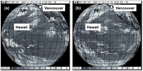
Figure 1. GOES-West Infrared satellite images of typical storm types affecting the western coast of North America in the winter season. Locations of Hawaii and Vancouver have been identified for (a) a typical winter storm (NP) from 28 January 2011, with a moisture source in the subarctic North Pacific. Precipitation for this storm had an oxygen isotope ratio of –9.1‰ (V-SMOW) in Vancouver. (b) Classic PE storm (PE) with a subtropical moisture source and characteristic atmospheric river form which occurred on 16 January 2011. Precipitation from this storm had an oxygen isotope ratio of –6.9‰ (V-SMOW). Images were retrieved from Environment Canada’s Weather Office (Citation2011) (January 16, 2011 and January 28, 2011).
ARs account for > 90% of the world’s water vapour transport towards the poles (Zhu and Newell Citation1998), are associated with rapid water vapour transport rates and can have substantial impacts on the North American Pacific coast. For example, observations from two eastern Pacific ARs (in 1998 and 2005) indicate the average water vapour transport rate was 13–26 km3/day (Ralph et al. Citation2005; Ralph et al. Citation2011), approximately 4 to 7.5 times the maximum discharge rate associated with the record Mississippi River flood of 2011 (Gierach et al. Citation2013). Once these PE storms make landfall, orographic lifting can result in extreme precipitation, flooding, debris flows, snow avalanches and high socio-economic costs (e.g. Higgins et al. Citation2000; Ralph et al. Citation2006; Neiman et al. Citation2008; Guan et al. Citation2010; Dettinger Citation2011; Dettinger et al. Citation2011; Lavers et al. Citation2011; Neiman et al. Citation2011; Dettinger et al. Citation2012). The warm temperatures can lead to rain-on-snow events, which amplify the potential for precipitation-induced natural hazards (Dettinger Citation2004; Dettinger et al. Citation2012).
One open question with PE storms is how their behaviour may change under different climate conditions. Paleo-proxy records of extreme floods suggest that there were several periods with extensive PE storms affecting the North American coast during the last 10,000 years (Ely et al. Citation1993; Kirby et al. Citation2012). Furthermore, model projections suggest that the frequency and magnitude of some extreme weather events could increase in the twenty-first century in response to global warming (Yin Citation2005; Salathe and Eric Citation2006; Tebaldi et al. Citation2006; Salathé et al. Citation2008; Jakob and Lambert Citation2009), which could also affect PE storm occurrence. An analysis of seven climate models suggests that years with multiple PE storms are likely to increase in the twenty-first century, but more extensive data are required to produce rigorous statistics (Dettinger Citation2011). Furthermore, Dettinger (Citation2011) focused on storms making landfall along the California coast, which could experience different behaviour than those making landfall on the southern British Columbia (BC) coast, in particular, if storm systems shift poleward as projected by climate model simulations (Yin Citation2005). Although a single PE storm can be severe and widespread, region-specific studies of PE storms are essential because differences in regional climate, geography, infrastructure and policy can affect the degree of risk associated with a given storm.
Identifying, predicting and managing risks associated with PE storms within a specific region, such as the Lower Mainland of BC, remains a challenge. In Canada, PE storm events are not readily documented by Environment Canada’s Weather Office because of a lack of specific criteria and thresholds for identification. Instead, “Pineapple Express” is used colloquially by newscasters and the public without a full understanding of PE characteristics (Parker Citation2009). The lack of an established definition of a true “Pineapple Express” event hinders the development of a chronology of events that would facilitate the analysis of temporal changes in PE storm frequency and magnitude as well as our ability to predict and manage the consequences of these storms.
One way to characterize PE storms affecting the Lower Mainland of BC is to examine the hydroclimatic characteristics of known PE storms and compare them with those of other North Pacific storms. Using the National Center for Environmental Prediction (NCEP) Reanalysis dataset to identify moisture pathways of Pacific winter storms, Dettinger (Citation2004) identified 206 PE storms that originated in the tropics and made landfall on the western North American coast (32.5–52.5°N) between 1948 and 1999. The meteorological and streamflow parameters of these storms likely differ from storms originating in the subarctic North Pacific due to differences in moisture source, temperature and magnitude of precipitation. Additionally, the sources of water vapour for different storm trajectories are likely to affect the oxygen isotope composition of precipitation (Friedman et al. Citation1992; Friedman et al. Citation2002; Price et al. Citation2008; Pape et al. Citation2010), with relatively higher δ18O values being associated with warm, subtropical PE air mass sources (Berkelhammer and Stott Citation2008; Pfahl et al. Citation2012). Thus, the air mass trajectory of each storm may be detectable from the isotopic signature of its precipitation, and may perhaps be used to inform studies attempting to generate long-term records of PE storms on the Pacific coast.
This study compares meteorological and streamflow data from storms originating in the subtropical and subarctic North Pacific, and explores what distinguishes PE storms from other Pacific storms affecting the Lower Mainland of BC. Additionally, new precipitation measurements from several storms in the Metro Vancouver area are used to investigate whether the oxygen isotope data of storm precipitation can be used to refine the definition of a PE storm, and thus potentially be used as a tool to catalogue the occurrence of different storm types. Finally, this study examines the temporal behaviour of PE storms, and identifies how this information might be used by resource managers to inform extreme weather hazard planning and mitigation.
Study area
Climate data from two sites in the Vancouver area of the Lower Mainland of BC were used: (1) the Vancouver International Airport and (2) the Capilano Watershed in North Vancouver (49°N 123°W, Figure ). The Vancouver Airport is situated in a low-lying, coastal area within the Fraser River Delta and has a continuous and reliable meteorological record. The climate is mild and wet, with an average annual temperature of 10.1°C and mean annual precipitation of 1199 mm (normals for 1971–2000 at the Vancouver International Airport station EC 1108447; Environment Canada Citation2012). The Capilano Watershed is situated at a higher elevation (~160 m above sea level) within the surrounding Coast Mountains. At a size of 19,800 ha, the Capilano watershed supplies 33% of Metro Vancouver’s drinking water supply (Metro Vancouver Citation2011a). The topography is characterized as rugged with steep slopes that have been affected by many glacial-interglacial cycles during the Pleistocene Epoch (Acres Citation1999). The dominant bedrock types in the Capilano watershed are intrusive igneous rocks such as granodiorite, diorite and quartz diorite (Roddick Citation1963). Mean annual precipitation is approximately 2044 mm (at Environment Canada’s North Vancouver meteorological station, EC 1105655).
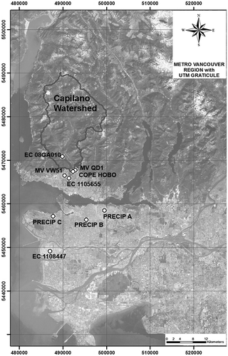
Figure 2. Map of the Metro Vancouver area showing the locations of the storm precipitation sampling sites, meteorological stations and hydrometric stations listed in Table
Table 1. Site information for all meteorological and hydrometric stations used in this study, and locations where storm precipitation samples were collected for isotopic analysis.
The Coast Mountain Range surrounding the Metro Vancouver area intensifies storms through orographic enhancement (Neiman et al. Citation2002), creating one of the wettest climates in Canada. Nearly three quarters of the annual precipitation is received in winter (November–March), with storm systems originating either in the subpolar or subtropical Pacific (Berkelhammer and Stott Citation2008).
Methods
Meteorological and streamflow variables
Meteorological characteristics of all storm events that occurred during a 10-year period (1998–2007) were extracted from the Vancouver International Airport meteorological record (Table ; Figure ). For this analysis, a storm event was defined as > 20 mm of precipitation falling in one 24-hour period. This threshold was selected somewhat arbitrarily because it represents a precipitation amount large enough to be considered an actual storm event and likely to have implications for water resource management. The time period 1998–2007 was chosen to allow for comparison between Vancouver storm events and an existing chronology of PE storms identified by Dettinger (Citation2008). Once all > 20 mm storm days were identified, meteorological variables, including total storm precipitation (P), temperature (T), wind speed (u) and atmospheric pressure (p), were recorded for each storm day.
In the Capilano region, data from the Capilano Watershed and Capilano Golf and Country Club meteorological stations were used (Table ; Figure ). However, data were only available from 2005–2007, and not all variables were available at each station. As a result, the total storm precipitation P values were taken from the Capilano Golf and Country Club station, while variables T and u were taken from the nearby Capilano Watershed station (Table , Figure ). Neither of the Capilano stations recorded atmospheric pressure. Day-of average streamflow, day-after average streamflow, and two-day total stream discharge were also included, using measurements from the Capilano River Above Intake hydrometric station (Table , Figure ).
Characterizing PE vs. non-PE storms, 1998–2007
To identify and isolate PE from non-PE storms, each > 20 mm storm day was compared to a chronology of PE events that made landfall between 32.5 and 52.5°N (Dettinger Citation2008). Storm days occurring on the day of, immediately before, or immediately after a Dettinger PE event were categorized as PE storms, as they were considered to have occurred due to the presence of a PE storm system in the area.
After estimating meteorological and streamflow variables for PE and non-PE storms at both sites (Table ), a Mann-Whitney test for unpaired data was used to identify if the median values of any variables were statistically distinct between the two storm types. Mann-Whitney (aka Rank Sum) is a non-parametric test used to compare the medians of two independent samples, with the null hypothesis that the “X” (PE storm) and “Y” (non-PE storm) populations are identical (Mann and Whitney Citation1947; Swinscow and Campbell Citation2002). If the sums of the ranks of each population are statistically different (in this case, with a p-value less than a threshold value of 5%, or p < 0.05), the null hypothesis is rejected, meaning that median values for PE storms differ significantly from non-PE storms for the variable considered. All statistical tests used in this study are summarized in Table .
Table 2. Meteorological and streamflow characteristics of all storm days at the Vancouver International Airport (1998–2007; N = 112) and the Capilano Watershed (mid 2005–2007; N = 94): daily mean temperature (T), 24-hour precipitation (P), wind speed (u), atmospheric pressure (p), streamflow (v) and stream discharge (V). A precipitation threshold of 20 mm was used to classify a “storm day”. Values are pulled directly from station data, except for 2-day total stream discharge, which was estimated from mean daily streamflow measurements. Pineapple Express (PE) storms accounted for 29 and 22% of all storm days at the Vancouver International Airport and the Capilano Watershed, respectively.
Table 3. Description of all the statistical tests used in this study and the variables each test was used to analyze. Statistical tests are described in more detail in the Methods section.
The 75th, 80th, 85th, 90th and 95th quantiles were estimated for meteorological (T, P, u, p) and streamflow variables for the populations of PE and non-PE storms. The quantiles of each variable were compared for the two populations of data (i.e. PE vs. non-PE storms) using the Wilcox’s robust statistics (WRS) package in R (Wilcox and Erceg-Hurn Citation2012). The WRS package uses the Harrell-Davis estimator, an estimate of the qth quantile using a weighted average of all the order statistics, and percentile bootstrap to compare the quantiles (Wilcox et al. Citation2012). Statistically significant differences were identified in all cases where the calculated p-value exceeded a critical p-value threshold. The 75th, 80th, 85th, 90th and 95th percentiles were chosen for the analysis because they represent the high-magnitude storm events, which are of greatest interest from a management perspective.
Isotopic analysis of storm precipitation, 2009–2011
The spatial variability in isotopic composition of global precipitation is largely temperature dependent. Warm air masses tend to hold moisture that is isotopically less depleted (i.e. “heavier”) than air masses from cooler regions (Dansgaard Citation1964; Rozanski et al. Citation1992). Since PE storm moisture is derived from low-latitude sources, condensation occurs at relatively warmer temperatures and with less-depleted δ18O values than for non-PE storms formed in the high-latitude North Pacific.
Storm precipitation samples were collected for oxygen isotope analysis from 27 storms between November 2009 and March 2011 (see Figure for sampling locations in Burnaby and Vancouver; Table ). Rainwater was collected over the duration of the precipitation event using a plastic funnel and collection bucket. The apparatus is a modified version of the sampling protocol outlined by the International Atomic Energy Agency (IAEA) (Friedman et al. Citation1992; IAEA Citation1997) and was used to reduce potential changes in the isotopic ratio of the water sample from evaporation. All storm precipitation samples were filtered using a 0.45-μm filter and kept frozen prior to analysis at the University of Saskatchewan Isotope Laboratory. A meteorological station was set up in the Capilano Watershed (HOBO-2; Figure ) in February 2010, to monitor temperature, precipitation and wind speed of the sampled storm events.
Since the Dettinger (Citation2008) PE chronology ends in 2007, GOES-West infrared satellite imagery (Environment Canada Citation2012) was used to classify the precipitation samples as PE or non-PE. A PE storm was identified when a winter storm showed evidence of a continuous AR from around Hawaii to the west coast of North America (Figure b). Satellite images from the days prior to each sampled storm event were reviewed to verify the AR trajectory of each storm. Storms that did not demonstrate a continuous AR configuration in satellite images were listed as non-PE storms.
Contribution of PE storms to annual precipitation and stream discharge, 1960–1995
The percent contribution of PE storms to the annual water budget was estimated by comparing the cumulative daily PE precipitation and stream discharge to the annual totals for each “water year”, (WY: 1 October–30 September). Precipitation data were taken from the Vancouver International Airport and the North Vancouver Capilano weather stations, and stream discharge was calculated from Capilano River Above Intake station daily average streamflow measurements (Table ; Figure ). The 1960–1995 time period was selected to allow maximum overlap between data sets, as continuous precipitation measurements for Capilano are only available from 1965–1985. As before, precipitation and stream discharge that occurred on the day of, the day preceding or the day after a catalogued Dettinger PE storm were considered to be a result of a PE storm system, and these values were totaled for each WY.
Temporal trends in PE frequency and annual storm maxima, 1948–2007
Precipitation data from the Vancouver International Airport meteorological station were used to estimate historical trends in average annual temperature and total annual precipitation, and to examine changes in frequency (# PE storm days/year) and annual storm maxima (maximum daily precipitation for the largest PE storm in a given year, in mm/day) of PE storms between 1948 and 2007 (Dettinger Citation2008). The North Vancouver Capilano meteorological station data were not included in this analysis due to the lack of continuous, long-term data. Only PE storms making landfall between 47.5 and 52.5°N (Dettinger Citation2008) were considered, so as to include only storms with direct implications for water resource management in Metro Vancouver. Because only this small geographical subset (i.e., 159 out of 392 PE storm days) was considered, the precipitation threshold of a “storm event” was lowered from > 20 mm/day to > 10 mm/day for the calculations of annual storm frequency and maxima. Reducing the storm event threshold increases the total number of storm days used in this analysis from 707 to 2415 days.
Finally, correlations between the annual average PE water vapour transport rate (estimated from Dettinger Citation2008) and annual average temperature, total annual precipitation, annual PE frequency and annual PE storm maxima were calculated. These were quantified using both the Pearson’s r and the non-parametric Spearman’s rank correlation coefficient.
Relationships to climate oscillations, 1960–1995
Several studies have found significant relationships between climate oscillations and climate variability along the western North American coast (Miles et al. Citation2000; Sobel and Maloney Citation2000; Cavazos and Rivas Citation2004; Dettinger Citation2004; Enloe et al. Citation2004; Jones et al. Citation2004; Wang et al. Citation2005; Abeysirigunawardena et al. Citation2009; Thorne and Woo Citation2011). This study investigated relationships between PE storm characteristics (e.g. frequency, annual storm maxima, % PE contribution to total annual precipitation) and the Pacific Decadal Oscillation (PDO), the El Niño Southern Oscillation (ENSO) and the Madden-Julian Oscillation (MJO). First, the PDO is a multi-decadal oscillation for which a positive phase represents a deepening of the Aleutian Low and an intensified sea-surface temperature (SST) gradient between the cool western and warm eastern Pacific (Mantua et al. Citation1997). The PDO Index (Mantua et al. Citation1997; Zhang et al. Citation1997) is defined as the primary component of SST variability in the Pacific Ocean poleward of 20°N (Joint Institute for the Study of Atmosphere and Ocean [JISAO] Citation2012). Second, ENSO operates on a timescale of ~3–7 years, and the positive (warm) El Niño phase is associated with high SST and atmospheric pressure anomalies in the eastern tropical Pacific (Trenberth Citation1997). The ENSO 3.4 Index was used and refers to SST anomalies in the El Niño 3.4 Region, which is bound by 120°W–170°W and 5°S–5°N (Trenberth Citation1997). Finally, the MJO is an intra-seasonal oscillation (~20–90 days) that influences regions of equatorial convection and precipitation and is most active in North American winter (Madden and Julian Citation1994; Jones et al. Citation2004). The positive phase of the MJO is associated with enhanced convection in the Indian Ocean, which is displaced into the western Pacific Ocean during the negative phase (Carrasco Citation2006; Barrett et al. Citation2012). Data for the MJO Index are available from 1979 onwards and are based on principal component analysis of the band pass-filtered 30-day 850-hPa zonal wind of the equatorial (5°N–5°S) (Maloney and Kiehl Citation2002; National Oceanic and Atmospheric Association [NOAA] Citation2003).
The relationships between the PDO, ENSO and MJO and the frequency and annual storm maxima of PE storms at the Vancouver International Airport (1960–1995) were measured using Pearson and Spearman’s rank correlation applied to yearly time series. The mean values of each index were also calculated for each WY (1 October to 30 September) for comparison with the percentage of PE contribution to total annual precipitation for each water year (1960–1995).
Results
Characteristics of PE storms, 1998–2007
From January 1998 to December 2007, the Vancouver International Airport meteorological station recorded 112 days with > 20 mm precipitation, 32 (29%) of which are classified as PE storms (Table ). At the Capilano site, 94 storm days with > 20 mm precipitation were recorded between 2005 and 2007, 21 (22%) of which are considered PE events (Table ). The largest recorded historical PE storm day had 68.5 mm of rain at the Vancouver International Airport and 89.2 mm of precipitation at North Vancouver Capilano station, on 19 January 1968.
Meteorological and streamflow characteristics
No statistically significant differences are found between the median values of PE and non-PE storm variables at Vancouver International Airport. At the Capilano site, the median values of three variables (precipitation, day-after streamflow and 2-day total stream discharge) demonstrate statistically significant differences (Table ). PE storms are associated with higher precipitation than non-PE storms (p < 0.01; Mann-Whitney test). The median value of PE storms is 45.6 mm/day, compared to 28.2 mm/day for non-PE storms. The median values of all discharge variables (day-of average streamflow, day-after average streamflow and 2-day total stream discharge) are higher for PE storms than non-PE storms in Capilano, but only differences between day-after average streamflow and 2-day total stream discharge are statistically significant (p < 0.05; Mann-Whitney test).
Table 4. Comparison of meteorological and streamflow characteristics of Pineapple Express (PE) and non-PE storms at two sites in Metro Vancouver, and resulting p-values from Mann-Whitney U tests (median) and Wilcox’s Robust statistics test (75th percentile). Significant relationships are shown in bold, and occur when the p-value < 0.05 or < p-critical. N is sample size.
A comparison of the 75th, 80th, 85th, 90th and 95th quantiles of PE and non-PE storms also shows no significant differences in high-magnitude PE and non-PE storms at the Vancouver International Airport. In Capilano, the upper quartile of PE storm precipitation (75th percentile = 72.2 mm) is statistically higher than that of non-PE storms (75th percentile = 38.4 mm). Furthermore, the 75th, 80th, 85th, 90th and 95th quantiles of all streamflow variables are statistically different for PE and non-PE storms, as is the 95th percentile daily mean temperature (Table ). When normalized for the area of the Capilano watershed, both the median and 75th quantile values for PE storm discharge are more than twice those for non-PE storms (Table ).
δ18O composition of storm precipitation
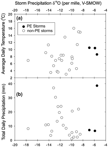
Of the 27 storm days sampled for isotopic analysis from November 2009 to March 2011, three were classified as PE storms based on GOES-West satellite images. The δ18O composition of the PE storm samples (N = 3) ranged from –5.53 to –6.88‰ V-SMOW (Vienna Standard Mean Ocean Water). In contrast, non-PE storm samples (N = 24) ranged from –17.66 to –8.5‰, with a mean value of –11.63‰ V-SMOW (Table ). A comparison between the oxygen isotope values, average daily temperatures and total daily precipitation suggests that while the temperature and precipitation characteristics of all storms are similar, the δ18O compositions of PE storms are consistently less depleted than those of non-PE storms (Figures a and b).
Table 5. Oxygen isotope composition and meteorological characteristics of Pineapple Express (PE) and non-PE storm precipitation in Metro Vancouver. N/A is not available.
Figure 3. Comparison of (a) average daily temperature (°C) and (b) total daily precipitation (mm) versus the oxygen isotope composition (δ18O, ‰, V-SMOW) of precipitation collected from 27 storms sampled in Vancouver, BC (Figure ; Table ). Storms were identified as Pineapple Express (PE, black dots) or non-Pineapple Express (non PE, open circles) using GOES-West Infrared satellite images that were examined on the date of sample collection. Temperature and precipitation data were estimated from the Vancouver International Airport meteorological station.
Contribution of PE storms to total annual precipitation and stream discharge
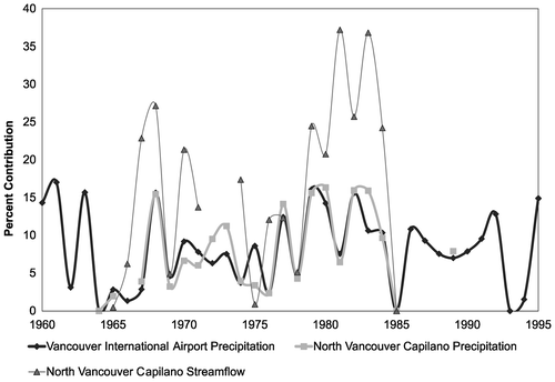
The contribution of PE storms to the annual water budget ranges from 0% (during weak PE seasons) to as much as 21 and 24% of the total annual precipitation at the Vancouver Airport (WY 1960–1995) and the North Vancouver meteorological station in the Capilano watershed (WY 1965–1985), respectively (Figure ). Even though the North Vancouver meteorological station records higher average annual precipitation than the Vancouver Airport station (2044 mm compared to 1199 mm), the percent contributions of PE precipitation to the annual totals are similar. The mean percent contributions to annual precipitation at the Vancouver Airport and Capilano are 11.0 and 11.9%, respectively. For the Capilano watershed, the percentage of total stream discharge in a given WY that occurs during PE storm conditions (1965–1985) ranges from 0 to 37%, with a mean of 16.5% (Figure ). The PE storm contribution to total streamflow is generally higher than the PE storm contribution to total annual precipitation, though the two data sets appear well correlated over time. This suggests that the rainfall runoff relationship is well defined and that the initial soil moisture content in the Capilano watershed is high. Groundwater levels from a groundwater observation well in Belcarra, BC (BC Observation well #349; British Columbia Ministry of Environment Citation2013) indicate saturated conditions over the winter (PE) season from October to May, which support these observations.
Figure 4. Comparison of the percent contribution of Pineapple Express (PE) storms to total annual precipitation and streamflow at two locations in Metro Vancouver, for water years 1960–1995. A “water year” is a 12-month period spanning 1 October–30 September each year. Note that continuous precipitation record measurements for Capilano watershed are only available from 1965–1985 (see Methods).
Frequency and annual storm maxima of PE storms exceeding 10 mm/day
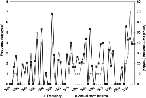
At the Vancouver International Airport, 90 days between January 1948 and December 2007 were identified as PE storms using the Dettinger chronology (Dettinger Citation2008) and a precipitation threshold of > 10 mm/day. The annual frequency of PE storms shows large interannual variability, with a range of 0–7 PE storm days/year (mean = 1.5 days/year). The number of distinct storm events in a given year can be lower than the total number of storm days in a year because one PE storm can last up to four days (Dettinger Citation2008), The largest PE storm maxima recorded at the Vancouver International Airport occurred on 18 January 1968, with 68.3 mm of precipitation in 24 hours. In general, PE storms making landfall in the Vancouver area are small precipitation events, and 75% of the annual storm maxima from 1948–2007 are < 30 mm/day (Figure ). Although no statistically significant trends are observed in PE storm frequency between 1948 and 2007, the years 2003–2005 exhibited an unprecedented three consecutive years with annual storm day maxima of approximately 40 mm or more. Furthermore, all three years rank within the top 10 PE annual storm maxima for 1948–2007.
Figure 5. Pineapple Express (PE) frequency and annual storm maxima in Metro Vancouver (47.5–52.5°N), 1948–2007. Frequency is displayed as the number of PE storm days/year identified by Dettinger (Citation2008), and PE storm maxima as the total precipitation measured at the Vancouver International Airport for the largest PE storm day in a given year (mm/day).
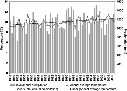
From 1948–2007, annual average temperature and total precipitation at the Vancouver International Airport showed an overall increasing trend (Figure ). Temperature increased by more than 1°C over this time period, at an average rate of ~0.02°C/year. The p value calculated using t approximation (Table ; Sheskin Citation2007) revealed that this trend is significant (p < 0.05). Total precipitation exhibited no significant trends and had high interannual variability, with a standard deviation of 178.67 mm and coefficient of variation of 0.15 (indicating that the variance is 15% of the mean).
Figure 6. Average annual temperature and total annual precipitation at the Vancouver International Airport from 1948–2007. Average annual temperature was calculated from monthly averages, and demonstrates an increasing trend of 0.02°C/year.
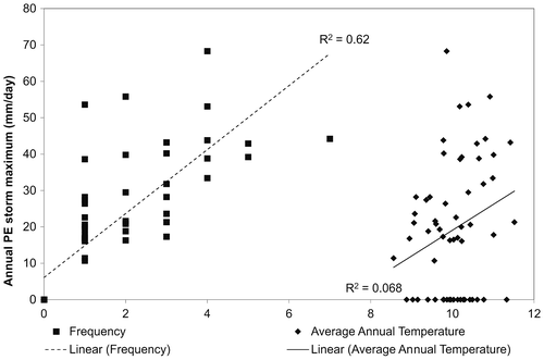
Linear regression analysis and a t approximation (Figure ) reveal that annual PE storm maxima (i.e. total precipitation for largest PE storm day in a given year) are significantly correlated to average annual temperature (Pearson r = 0.26, p < 0.05), total annual precipitation (Pearson r = 0.39, p < 0.01), annual PE frequency (i.e. # PE storm days/year; Pearson r = 0.79, p < 0.01) and annual average PE vapour transport rate (i.e. mean daily PE vapour transport rate for a given year, Pearson r = 0.46, p < 0.01). Annual PE frequency is also significantly correlated with annual water vapour transport rate (Pearson r = 0.39, p < 0.01) and total annual precipitation (Pearson r = 0.45, p < 0.01). The Spearman rank correlation coefficient indicated similar conclusions, although the t approximation (Sheskin Citation2007) revealed slightly weaker relationships (p > 0.05).
Figure 7. Relation between annual Pineapple Express (PE) storm maxima (mm/day) with average annual temperature (°C) and annual PE storm frequency (number of PE storm days/year), at the Vancouver International Airport (1948–2007). Dettinger (Citation2008) was used to identify PE storms making landfall in the Vancouver area between 47.5 and 52.5°N. Both positive correlations to annual storm maxima are significant.
Correlation with climate oscillations
The percentage of PE precipitation calculated for the WY at Vancouver International Airport exhibits a strong, statistically significant, negative lag 0 correlation to mean annual values for the MJO estimated from 1 October–30 September (Spearman rank, ρ = –0.59; p < 0.05; Figure ). The MJO index for the calendar year is also significantly correlated at lag 0 with annual PE frequency (Spearman rank, ρ = 0.81, p < 0.01; Table ). This significant correlation suggests that years with more positive MJO indices tend to produce higher numbers of PE storms. In contrast, PDO and ENSO indices exhibit no statistically significant relationships with PE storm frequency, annual PE maxima and percent contribution of PE storms to annual precipitation (Table ).
Figure 8. Relation between the Madden Julian Oscillation (MJO) and the percent contribution of Pineapple Express (PE) storms to total precipitation at the Vancouver International Airport for water years (1 October–30 September) 1980–1995. The MJO Index shown here is the annual average calculated from daily MJO indices (Maloney and Kiehl Citation2002; NOAA 2003).
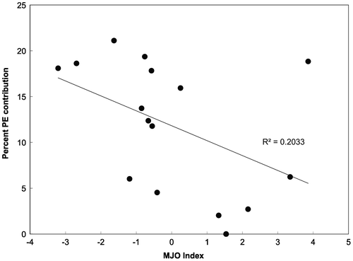
Table 6. Spearman rank correlation coefficients (ρ) and p values comparing climate indices (PDO, ENSO and MJO) to PE characteristics (frequency, annual storm maxima and percent contribution to total annual precipitation), 1960–1995. Significant values in bold.
Discussion
Distinguishing characteristics of PE storms
Results of the Mann-Whitney and WRS tests reveal that PE storms produce statistically greater amounts of precipitation and stream discharge than non-PE storms in the Capilano watershed, especially when considering only the most extreme (upper 75th through 95th quantile) storm events. The differences are statistically significant at Capilano, but not at the Vancouver International Airport, likely because the high-elevation, mountainous terrain of the Capilano watershed amplifies the precipitation effects of storms. In fact, the 75th quantile of PE storm precipitation in Capilano is nearly double that for non-PE storms. Similarly, because of the stream response to large inputs of precipitation, the day-of, day-after and 2-day total stream discharge in the Capilano River are also higher with a PE storm. Comparing the 75th percentiles reveals that 2-day total mean stream discharge is nearly 250% greater for PE events than non-PE events. Dettinger (Citation2004) also found that PE storms in the Sierra Nevada yield about twice as much precipitation, and streamflows on the Merced River in Yosemite National Park are approximately one order of magnitude higher following a PE event than are other winter storms.
This study demonstrates that PE storms identified via overall morphological characteristics on satellite imagery consistently deliver precipitation with greater δ18O composition than non-PE storms. The ~5.5‰ difference between PE and non-PE storms can be attributed to different sources of storm precipitation. Whereas PE storms have a subtropical source (Dettinger Citation2004; Dettinger et al. Citation2011; Ralph and Dettinger Citation2011), other storms affecting Metro Vancouver originate in the cooler northern Pacific Ocean (Stewart et al. Citation1995). The oxygen isotope measurements from the Vancouver precipitation samples are also consistent with measurements from previous studies in California (Berkelhammer and Stott Citation2008; Oster et al. Citation2012). Oster et al. (Citation2012) sampled two PE storms in the early spring that were isotopically enriched in 18O compared to other early spring precipitation events. In southern California, the δ18O of winter PE storm precipitation ranged from –2.2 to –3.3‰ compared to non-PE storms, which ranged from –6.2 to –11.5‰ (Berkelhammer and Stott Citation2008).
Contribution of PE storms to total annual precipitation and streamflow
Although infrequent, PE storms contribute disproportionately large amounts to total annual precipitation in Vancouver and can account for up to one quarter of the city’s annual precipitation, theoretically in a single storm. These results are consistent with Dettinger et al. (Citation2011), who found that PE storms making landfall between Washington and California contributed up to 25% to total annual precipitation from WY 1951–2008. The largest contributions are found in northern California, with values generally decreasing further north and further inland. In Bellingham, Washington, the closest station to Metro Vancouver, the PE contribution to total annual precipitation averaged 15% between WY 1951 and 2008 (Dettinger et al. Citation2011).
The annual contribution of PE storms to total stream discharge is even higher than that of precipitation (16.5% on average, with a maximum of 37%). The enhanced contribution from PE storms is likely due to PE storms behaving as “rain-on-snow” events. Warm, subtropical PE rain melts existing snowpack on the ground, which runs off into surface water bodies, causing a disproportionately high streamflow response (Dettinger Citation2004). Again, results are consistent with Dettinger et al. (Citation2011) who also found PE contribution to streamflow to be higher than the contribution to total annual precipitation. In mid-California from WY 1949 to 2008, approximately 55% of annual stream discharge can be attributed to PE events. Percent contributions generally decrease northward, and hydrological stations in northwest Washington average around 15% annual PE contribution over the same time period (Dettinger et al. Citation2011).
Trends in PE storm behaviour
PE storms make landfall in and around the Vancouver area (47.5–52.2°N) between 1–2 days/year on average, with a maximum of 7 PE storms days/year between 1948 and 2007. For comparison, PE storms occur approximately 4 days/year across the entire west coast of North America from 32.5–52.2°N (Dettinger Citation2004). From 2003–2007, the Vancouver area experienced an unprecedented five-year period with > 2 PE storm days/year, and the years 2004–2007 rank as four of the top 10 years for PE frequency (1948–2007), suggesting a possible change in storm behaviour in recent years. Dettinger (Citation2004) found evidence of an overall increasing trend in the annual frequency of PE circulations in western North America from 1948–1999 (+0.18 days/year, p = 0.2); however, his results were accompanied by a word of caution: the NCEP reanalysis data used to establish the trend were considered less reliable prior to 1979 due to a lack of comparable satellite imagery (Dettinger Citation2004; Bylhouwer et al. Citation2013).
The positive correlations between PE annual storm maxima with PE frequency and total annual precipitation (1948–2007) suggest that strong PE years can bring numerous high-magnitude storm events over a single season. Linear regression also indicates a statistically significant positive correlation between the PE storm day maxima and annual average temperature. Given that warmer years tend to be associated with the highest-magnitude PE storms, one potential implication of this correlation is that rising global temperatures could lead to increased PE storm activity. Annual average temperature at the Vancouver Airport has increased at a rate of 0.02°C/year from 1948–2007 (Figure ). Furthermore, global climate model projections suggest annual temperatures in BC could increase by +1.7°C (+1.2°C to +2.5°C) compared with a 1961–1990 baseline (Rodenhuis et al. Citation2009). The Canadian Regional Climate Model (CRCM4) estimates a +2.6°C (+2.0°C to +3.0°C) warming over the same time period (Rodenhuis et al. Citation2009). If temperatures continue to rise, evidence suggests that warmer years in the future could result in greater PE storm day maxima than typically seen in the past and may lead to increased damages and costs to society.
Relationships with climate oscillations
According to previous research which has investigated cyclone activity (Wang et al. Citation2005), synoptic-scale circulation patterns (Stahl et al. Citation2006) and temperature and precipitation patterns recorded at meteorological stations (Fleming and Whitfield Citation2010), El Niño years tend to bring warmer temperatures and less precipitation to BC than their La Niña counterparts. Positive (warm) PDO years tend to have variable effects on precipitation, and negative (cool) PDO years tend to be associated with wetter conditions. In this study, the comparisons between PDO and ENSO indices and PE storm characteristics (frequency, annual storm day maxima and contribution to annual precipitation) show no significant correlation over the interval of 1960 to 1995 (Table ). This comparison was based on the subset of PE storms making landfall in the region of the Lower Mainland of BC, between 47.5 and 52.5°N. Using the complete dataset of PE storms that made landfall between 32.5 and 52.5°N, Dettinger (Citation2004) also found no correlation between the frequency and magnitude of PE storms and ENSO. Nonetheless, Dettinger (Citation2004) did note that every El Niño season from 1948–2004 had a minimum of one PE event, whereas > 50% of La Niña seasons had no PE storms. The strongest PE seasons have occurred during neutral ENSO years, in phase with a positive PDO, when the westerlies are further south and have greater access to warm, subtropical moisture (Mantua et al. Citation1997). As the PDO is a multi-decadal oscillation, the time series from the Vancouver International Airport used in this study may be too short to resolve low frequency climate variability. Furthermore, it is worth noting that this analysis has only calculated the correlations between PDO and PE storms with a 0 lag-time between them. Since the effects of climate oscillations can sometimes be delayed, future studies could examine larger lag times, as well as comparisons on sub-annual (monthly to seasonal) timescales.
The relationships between PE characteristics and the MJO are much stronger than those with the PDO or ENSO, especially as expressed by Spearman’s rank correlation coefficient which indicates that MJO index and PE variables increase or decrease together, but may not necessarily do so in a linear fashion. The MJO exerts a significant negative correlation to the percent contribution of PE storms to total precipitation and a significant positive correlation to PE frequency (Vancouver International Airport, WY 1980–1995). The physical explanation for this result is that when the MJO is in a negative phase, enhanced convection occurs in the western equatorial Pacific Ocean, which can fuel PE storms that contribute more precipitation to annual totals. These results are similar to other studies which have found significantly higher mean daily and monthly precipitation amounts during the negative phase of the MJO than during the positive phase (Carrasco Citation2006; Nazemosadat and GHaed Amini AsadAbadi Citation2009; Barrett et al. Citation2012). The MJO is believed to exert a strong influence on the PE storms because tropical temperature anomalies associated with the MJO allow for the development of the characteristic 500-hPa geopotential height anomalies of PE events (Lackmann and Gyakum Citation1999). This mid-tropospheric pressure pattern allows low pressure cyclones to develop along cold fronts, which drive warm, subtropical air to the west coast of North America along a persistent storm track (Ralph et al. Citation2004; Neiman et al. Citation2008). On rare occasions, heavy tropical rainfall from the MJO in the Indian Ocean can feed tropical moisture directly into the PE system as it shifts eastwards. This phenomenon creates the most severe type of PE storm, coined as a “tropical punch” by meteorologists (Mo Citation2011).
The long (multi-annual and multi-decadal) time scale of ENSO and PDO oscillations could mean that they exert influence overall seasonal hydroclimatic (precipitation and streamflow) characteristics with limited impact on individual extreme storm events that occur only 1–2 days/year in southwest BC. Alternatively, the ENSO or PDO oscillations could influence extreme meteorological conditions following some lag period, which was not tested here. In either case, the MJO is a shorter term oscillation (20–90 days) that is more closely related to atmospheric dynamics that can influence individual, extreme storm behaviour resulting from rapid atmospheric vapour transport. The strong correlation between PE storms and the MJO supports the notion that the MJO is considered to be the dominant mode of intraseasonal variability in the equatorial tropics (Jones et al. Citation2004).
Relationship between PE storms, water resources and natural hazards in BC
The distinctive hydroclimatic characteristics of PE storms translate into socioeconomic risks that must be managed accordingly. The intense precipitation and rapid streamflow of PE storms in the Metro Vancouver area highlight two major causes for concern: impacts to municipal water resources (supply and quality) and the increased potential for precipitation-induced natural hazards.
PE storms play a dichotomous role for regional water supply in the Lower Mainland. The powerful storms can create excess runoff and flooding hazards during the winter season, but also store water as snowpack at higher elevations which is essential for maintaining adequate supply during dry summer periods (Environment Canada Citation2004). Recent research suggests that PE storms play a key role in ending periods of prolonged drought in the Pacific Northwest (Dettinger Citation2013). In Metro Vancouver, PE storms contribute up to 24% of the total annual precipitation, and thus the occurrence of major PE storms over a winter season might help to alleviate summer drought conditions. Future demand-side management protocols may need to be considered as population growth places increased pressure on water resources, and climate change contributes to summer drought conditions (ACT Citation2011; Metro Vancouver Citation2011b).
PE storms contribute to decreased water quality through slope failures and channel instability that can lead to turbid water, increased treatment costs and potential health risks (Jakob and Weatherly Citation2003). The Capilano drinking water reservoir is vulnerable to elevated turbidity due to local geology and steep terrain, particularly in areas overlain by fine-textured glacio-lacustrine deposits (Armstrong Citation1990). Storm events trigger the release of fine sediments and organic particulates in suspended or dissolved form, which gives the water a cloudy appearance and may render it unsuitable for drinking water use. The highest recorded turbidity values are typically associated with slope failures such as debris flows and/or gully erosion in the watershed. For example, on 16 November 2006, a PE precipitation event triggered a debris flow in the Capilano Reservoir, causing turbidity reach a maximum annual value of 42 NTU (Greater Vancouver Regional District Citation2007). For reference, nearly 95% of days in 2006 measured < 1 NTU. One of the leading factors in landslide initiation in the North Shore Mountains is antecedent precipitation, which can enhance soil moisture and weaken slope stability (Jakob and Weatherly Citation2003). In this case, two PE storm days early in November 2006 (identified using the Dettinger Citation2008 chronology) likely contributed to debris flow initiation on 16 November 2006. During these events, alternative sources (Seymour and Coquitlam watersheds) that treat and disinfect water are utilized as drinking water for Metro Vancouver (City of Vancouver Citation2011). The PE storms in November 2006 triggered landslides and debris flows in the Seymour and Coquitlam reservoirs, leading to a boil water advisory for more than 2 million people across the entire Greater Vancouver area (Natural Resources Canada Citation2009).
PE storms can also decrease water quality through diffuse and point-source pollution. Stormwater can contain motor oil, gasoline, sediment, fertilizer and other contaminants (Metro Vancouver Citation2011c) or lead to sanitary sewer overflows (SSOs) during periods of heavy rainfall (Hall et al. Citation1991; MacDonald et al. Citation1997; Metro Vancouver Citation2011c). Of the utmost concern are combined sewer outflows (CSOs), a legacy of the region’s original sewerage system that allows wastewater and storm water run through the same pipe. Combined sewers are being replaced by separate sanitary and storm sewers, but the high cost of infrastructure replacement creates a challenge for storm water mitigation (Metro Vancouver Citation2010).
In some instances, PE storms may be directly related to the occurrence of natural hazards. For this study, a comparison of the 382 storm days identified by Dettinger (Citation2008) with records of flooding, avalanches and debris flows in northern BC (Septer Citation2007) shows that 74 of those days (19.4%) correspond with a natural hazard. Flooding was the most frequently observed natural hazard, coinciding with 60% of all PE storms (N = 37) between 1950 and 2006. Snow avalanches and landslides/debris flows occurred with 41% and 24% of all PE storms. The arrival of PE storms also corresponds with debris flows affecting residents near Chilliwack, BC. Of 18 debris flows reported between 1980 and 2007 in the Hatzic Valley and the Bridal Falls Corridor near Chilliwack, 11 (61%) correspond to a PE storm making landfall between 45 and 52.5°N (Sutton Citation2011). The higher precipitation rates of PE storms and their occurrence during the rain-on-snow season could lead to an enhanced association between debris flows and PE storms.
Planning for future PE events
Positive relationships between annual PE storm maxima, annual PE storm frequency and average annual temperature have been documented in this study, and could have implications for the future impacts of PE storms in the Lower Mainland as climate warms. A multi-model analysis using the A2 emissions scenario suggests that average PE storms may not change much into the twenty-first century, but years with multiple PE storms and PE storms with higher-than-historical water vapour transport rates are both likely to increase (Dettinger Citation2011). Municipal and provincial climate change adaptation policies for extreme weather events in the Metro Vancouver area need to account for these projected changes in extreme PE storm patterns. In 2008, the Province of British Columbia committed $95 million to municipalities for climate change adaptation research and policy development (Henstra and McBean Citation2009; British Columbia Ministry of Environment Citation2010). Current plans to minimize the risks from future increases in the intensity and frequency of heavy rain events include the design and implementation of a citywide integrated stormwater management plan by 2014 (City of Vancouver Citation2012), the reduction of non-point-source pollution through implementation of stormwater Best Management Practices (BMPs) for waterfront businesses (Burrard Inlet Environmental Action Program [BIEAP] Citation2010), and the construction of a new drinking water treatment facility in the Lower Seymour Conservation Reserve (Metro Vancouver Citation2011b). Currently, risk management strategies consider both the severity and probability of impacts, but do not include potential scenarios that account for the inter- and intra-annual variability of winter storm patterns, including the most severe types of PE storms, a PE superstorm. Wet-weather sewer overflows can occur with storms having return periods of 1:2 or 1:5 (Metro Vancouver Citation2010), so extremely large storm events drastically increase the potential for overflows and other negative impacts.
More emphasis could be placed on addressing specific adaptation measures for these rare storms in BC. For example, the largest PE superstorm in recent history was recorded in 1861–1862 in California and has an estimated reoccurrence rate of 150–400 years (Porter et al. Citation2011). The storm produced record precipitation, extensive flooding and hundreds of landslides that contributed to a death toll in the thousands. The population of California has increased a hundred-fold since 1860, and the reoccurrence of an event this size could result in hundreds of billions of dollars in damages (Porter et al. Citation2011). The United States Geological Survey (USGS) Multihazards Project has begun planning for “ARkStorm”: a hypothetical PE superstorm scenario modelled after the storm event of 1861–1862. The goal is to map the socioeconomic impacts of a PE superstorm across California, and to identify and remediate vulnerabilities (Dettinger et al. Citation2012). Since PE storms can occur across the entire latitudinal range of western North America, it is reasonable to assume that a superstorm of this magnitude could make landfall in the Lower Mainland of BC. Vancouver could adapt ARkStorm conditions to the environment and socioeconomics specific to their own city, and demonstrate how they have prepared for even the worst-case scenario.
Conclusions
Pineapple Express (PE) storms are warm, wet and intense atmospheric rivers (ARs) that have not previously been well characterized in the Lower Mainland of BC. By identifying storms using an independent chronology of PE events (Dettinger Citation2008), this study shows that PE storms bring statistically higher precipitation and statistically larger streamflows in the Capilano watershed, particularly when considering the more extreme (75th, 80th, 85th, 90th and 95th percentiles) storms. PE storms are also distinguishable by the oxygen isotopic composition of their precipitation, in that PE storms identified with satellite imagery as originating in the subtropical Pacific Ocean exhibited substantially less-depleted oxygen isotope ratios compared with non-PE storms. An analysis of meteorological records from 1948 to 2007 suggests that Vancouver has experienced anywhere from 0–7 PE storm days/year, which contribute an average of 11 and 17% to annual precipitation and stream discharge totals. Both the PE frequency (# storm days/year) and annual storm day maxima (mm precipitation/day) exhibit high interannual variability without any long-term trends.
The frequency and magnitude of PE circulations are also influenced by their response to climate oscillations and a warming climate. Results indicate that the percent contribution of PE precipitation to total annual precipitation is strongly negatively correlated to the Madden-Julian Oscillation (MJO) Index. In other words, water years with higher percentages of PE rain tend to occur during negative phases of the MJO, when convection in the western equatorial Pacific Ocean is enhanced. MJO tropical precipitation anomalies serve as a moisture source for the subtropical PE system, and fuel the high-magnitude AR storms on the west coast of North America as the MJO propagates eastward. Additionally, the annual PE storm maxima are positively correlated to annual average temperatures. Since PE storms in Metro Vancouver have been linked to water supply, water quality and precipitation-induced natural hazards, a warmer climate could result in a higher occurrence of high-magnitude PE storms capable of costly damages and risks to public safety.
This work has explored PE characteristics and trends for the Lower Mainland of BC and provides some insights on the contributions of PE storms to annual precipitation and streamflows. Future work could focus on assessing long-term trends using longer time series, which would help to identify controlling factors by including more PE storms in the analysis. Extending the record of PE events can also be achieved by maintaining an up-to-date chronology of PE events in future. Using the criteria outlined by Dettinger (Citation2004), the Dettinger (Citation2008) PE record can be extended using large-scale reanalysis data. These results also suggest that isotopic sampling of storm precipitation coupled with satellite imagery has the potential to distinguish storm trajectories and moisture sources. A more rigorous storm precipitation sampling methodology performed over a longer time frame would allow for further investigation into controls over the isotopic composition of precipitation, and has the potential to distinguish between true PE storms, near misses, and the most intense “Tropical Punch” PE storms that can originate in the eastern Indian Ocean.
From a policy perspective, it is recommended that the City of Vancouver consider the potential environmental and socioeconomic impacts that could result from a superstorm scenario. The city has drafted a climate change adaptation strategy (City of Vancouver Citation2012), but more emphasis should be placed on addressing the low-probability but extremely high-magnitude storm events on the scale of the PE superstorm that decimated California over the winter of 1861–1862.
Acknowledgements
We thank M. Dettinger for useful insights and providing access to unpublished data, and A. Cooper, L. Sutton and members of the Climate, Oceans and Paleoclimate (COPE) Laboratory and the Climate Impact Research Consortium (CCIRC) for helpful discussions. This manuscript has been improved by the input of two anonymous reviewers and the Associate Editor of CWRJ. This work was supported by a Simon Fraser University Community Trust Endowment Fund grant to D.M. Allen, K. Lertzman and K.E. Kohfeld, as well as K. E. Kohfeld’s Natural Sciences and Engineering Research Council (NSERC) Canada Research Chair program and Discovery Grant.
References
- Abeysirigunawardena, D. S., E. Gilleland, D. Bronaugh, and P. Wong. 2009. Extreme wind regime responses to climate variability and change in the inner south coast of British Columbia, Canada. Atmosphere-Ocean 47(1): 41–62.
- Acres. 1999. GVRD Watershed Ecological Inventory Program, Annex to the analysis report. Watershed Management Plan #5, Volume 1. Vancouver, BC, Acres International, B. Thompson, B.A. Blackwell and Associates Ltd., J.M. Ryder and Associates Terrain Analysis, Northwest Hydraulic Consultants Limited, Oikos Ecological Services Ltd., Phero Tech Inc., Timberline Forest Inventory Consultants.
- Adaptation to Climate Change Team (ACT). 2011. Background report: Climate change adaptation and water governance. Vancouver, BC: Simon Fraser University.
- Armstrong, J. E. 1990. Vancouver geology. Vancouver, BC: The Geological Association of Canada.
- Barrett, B. S., J. F. Carrasco, and A. P. Tesino. 2012. Madden-Julian Oscillation (MJO) modulation of atmospheric circulation and Chilean winter precipitation. Journal of Climate 25(5): 1678–1688.
- Berkelhammer, M., and L. Stott. 2008. Recent and dramatic changes in Pacific storm trajectories recorded in δ18O from Bristlecone Pine tree ring cellulose. Geochemistry Geophysics Geosystems 9(Q04008): doi:10.1029/2007GC001803.
- British Columbia Ministry of Environment. 2010. Preparing for climate change: British Columbia’s adaptation strategy. Victoria, BC: Government of British Columbia.
- British Columbia Ministry of Environment. 2013. British Columbia groundwater observation network. http://www.env.gov.bc.ca/wsd/data_searches/obswell/map/obsWells.html (accessed August, 2013).
- Burrard Inlet Environmental Action Program (BIEAP). 2010. Who knows where the stormwater goes? A pilot project to promote stormwater best management practices in Vancouver. Vancouver, BC: Burrard Inlet Environmental Action Program.
- Bylhouwer, B., D. Ianson, and K. Kohfeld. 2013. Changes in the onset and intensity of wind-driven upwelling and downwelling along the North American Pacific Coast. Journal of Geophysical Research –Oceans 118: 1–16.
- Carrasco, J.F. 2006. Precipitation events in central Chile and its relation with the MJO. In Proceedings of the Eighth International Conference on Southern Hemisphere Meteorology and Oceanography, Foz do Iguacu, Brazil, April 24–29, 2006, 1719-1722. American Meteorological Society.
- Cavazos, T., and D. Rivas. 2004. Variability of extreme precipitation events in Tijuana, Mexico. Climate Research 25: 229–243.
- City of Vancouver. 2011. Drinking water quality 2010 annual report. Vancouver, BC: City of Vancouver.
- City of Vancouver. 2012. Climate change adaptation strategy. Vancouver, BC: The Sustainability Group.
- Dansgaard, W. 1964. Isotopes in precipitation. Tellus 16(4): 436–468.
- Dettinger, M. 2004. Fifty-two years of “Pineapple-Express” storms across the west coast of North America: California Energy Commission PIER Energy-Related Environmental Research Report. Scripps Institution of Oceanography for the California Energy Commission. La Jolla, CA: US Geological Survey.
- Dettinger, M. 2005. A long-term (~50-yr) historical perspective on flood-generating winter storms in the American River basin. In Proceedings of the California Extreme Precipitation Symposium, April 22, 2005, Sacramento, CA. http://cepsym.org/proceedings_2005.php (accessed July, 2014)
- Dettinger, M. 2008. Pineapple express record 1948–2007, Unpublished Data. C. Spry. Vancouver, BC.
- Dettinger, M. 2011. Climate change, atmospheric rivers, and floods in California: A multimodel analysis of storm frequency and magnitude changes. Journal of the American Water Resources Association (JAWRA) 47(3): 514–523.
- Dettinger, M. D. 2013. Atmospheric rivers as drought busters on the US west coast. Journal of Hydrometeorology 14(6): 1721–1732.
- Dettinger, M. D., F. M. Ralph, T. Das, P. J. Neiman, and D. R. Cayan. 2011. Atmospheric rivers, floods, and water resources in California. Water 3: 445–478.
- Dettinger, M. D., F. M. Ralph, M. Hughes, T. Das, P. Neiman, D. Cox, G. Estes, D. Reynolds, R. Hartman, D. Cayan, and L. Jones. 2012. Design and quantification of an extreme winter storm scenario for emergency preparedness and planning exercises in California. Natural Hazards 60: 1085–1111.
- Ely, L. L., Y. Enzel, V. R. Baker, and D. R. Cayan. 1993. A 5000-year record of extreme floods and climate change in the Southwestern United States. Science 262: 410–412.
- Enloe, J., J. J. O’Brien, and S. R. Smith. 2004. ENSO impacts on peak wind gusts in the United States. Journal of Climate 17(8): 1728–1737.
- Environment Canada. 2011. Weather information. http://www.weather.gc.ca (accessed January 16, 2011 and January 28, 2011).
- Environment Canada. 2004. Threats to water availability in Canada. NWRI Scientific Assessment Report Series No. 3 and ACSD Science Assessment Series No. 1. Burlington: National Water Research Institute.
- Environment Canada. 2012. Canadian weather. http://www.weatheroffice.gc.ca/canada_e (accessed March, 2012).
- Fleming, S. W., and P. H. Whitfield. 2010. Spatiotemporal mapping of ENSO and PDO surface meteorological signals in British Columbia, Yukon, and southeast Alaska. Atmosphere-Ocean 48(2): 122–131.
- Friedman, I., J. M. Harris, G. I. Smith, and C. A. Johnson. 2002. Stable isotope composition of waters in the Great Basin, United States 1. Air-mass trajectories. Journal of Geophysical Research 107(D19): 4400.
- Friedman, I., G. I. Smith, J. D. Gleason, A. Warden, and J. M. Harris. 1992. Stable isotope composition of waters in southeastern California: 1. Modern precipitation. Journal of Geophysical Research 97: 5795–5812.
- Gierach, M. M., J. Vazquez-Cuervo, T. Lee, and V. M. Tsontos. 2013. Aquarius and SMOS detect effects of an extreme Mississippi River flooding event in the Gulf of Mexico. Geophysical Research Letters 40(19): 5188–5193.
- Greater Vancouver Regional District (GVRD). 2007. The Greater Vancouver water district quality control annual report 2007: Volume 2 – chemical and physical monitoring results. Vancouver, BC: The Greater Vancouver Regional District.
- Guan, B., B. Guan, N. P. Molotch, D. E. Waliser, E. J. Fetzer, and P. J. Neiman. 2010. Extreme snowfall events linked to atmospheric rivers and surface air temperature via satellite measurements. Geophysical Research Letters 37(L20401): doi:10.1029/2010GL044696.
- Hall, K. J., H. Schreier, and S. J. Brown.1991. Water quality in the Fraser River Basin. In Water in sustainable development: Exploring our common future in the Fraser River Basin, eds. A. H. J. Dorcey and J. R. Griggs, 41–75. Vancouver, BC: Westwater Research Centre, The University of British Columbia.
- Henstra, D., and G. McBean. 2009. Climate change and extreme weather: Designing adaptation policy. Vancouver, BC: Adaptation to Climate Change Team.
- Higgins, R. W., J.-K. E. Schemm, W. Shi, and A. Leetmaa. 2000. Extreme precipitation events in the western United States related to tropical forcing. Journal of Climate 13(4): 793–820.
- International Atomic Energy Agency (IAEA). 1997. Technical procedure for sampling. http://www-naweb.iaea.org/napc/ih/documents/userupdate/sampling.pdf (accessed September, 2011).
- Jakob, M., and S. Lambert. 2009. Climate change effects on landslides along the southwest coast of British Columbia. Geomorphology 107(3–4): 275–284.
- Jakob, M., and H. Weatherly. 2003. A hydroclimatic threshold for landslide initiation on the North Shore mountains of Vancouver, British Columbia. Geomorphology 54(3–4): 137–156.
- Joint Institute for the Study of the Atmosphere and Ocean (JISAO). 2012. PDO Index. http://jisao.washington.edu/pdo/PDO.latest (accessed February, 2012).
- Jones, C., D. E. Waliser, K. M. Lau, and W. Stern. 2004. Global occurrences of extreme precipitation and the Madden-Julian Oscillation: Observations and predictability. Journal of Climate 17: 4575–4589.
- Kirby, M. E., S. R. H. Zimmerman, W. P. Patterson, and J. J. Rivera. 2012. A 9170-year record of decadal-to-multi-centennial scale pluvial episodes from the coastal Southwest United States: a role for atmospheric rivers? Quaternary Science Reviews 46: 57–65.
- Lackmann, G. M., and J. R. Gyakum. 1999. Heavy cold-season precipitation in the Northwestern United States: Synoptic climatology and an anlysis of the flood of 17–18 January 1986. Weather and Forecasting 14: 687–700.
- Lavers, D. A., R. P. Allan, E. F. Wood, G. Villarini, D. J. Brayshaw, and A. J. Wade. 2011. Winter floods in Britain are connected to atmospheric rivers. Geophysical Research Letters 38(L23803): doi:10.1029/2011GL049783.
- MacDonald, R. H., K. J. Hall, and H. Schreier. 1997. Water quality and stormwater contaminants in the Brunette River Watershed: Water sampling program 1994/1995. Vancouver, BC: Westwater Research Unit, Institute of Resources and Environment, The University of British Columbia.
- Madden, R. A., and P. R. Julian. 1994. Observations of the 40–50-day tropical oscillation: A review. Monthly Weather Review 122: 814–837.
- Maloney, E. D., and J. T. Kiehl. 2002. MJO-related SST variations over the tropical eastern Pacific during Northern Hemisphere summer. Journal of Climate 15: 675–689.
- Mann, H. B., and D. R. Whitney. 1947. On a test of whether one of two random variables is stochastically larger than the other. Journal of Statistical Computing and Simulation 13: 41–48.
- Mantua, N. J., S. R. Hare, Y. Zhang, J. M. Wallace, and R. C. Francis. 1997. A Pacific interdecadal climate oscillation with impacts on salmon production. Bulletin of the American Meteorological Society 78: 1069–1079.
- Metro Vancouver. 2010. Integrated liquid waste and resource management: A liquid waste management plan for the Greater Vancouver Sewerage & Drainage District and member municipalise. Burnaby, BC: Metro Vancouver.
- Metro Vancouver. 2011a. Sources & supply. http://www.metrovancouver.org/services/water/source/Pages/default.aspx (accesssed April, 2013).
- Metro Vancouver. 2011b. Drinking water management plan. Burnaby, BC: Metro Vancouver Sustainable Region Initiative.
- Metro Vancouver. 2011c. Stormwater management. http://www.metrovancouver.org/services/wastewater/sources/Pages/StormwaterManagement.aspx (accessed April, 2012).
- Miles, E. L., A. K. Snover, A. F. Hamlet, B. M. Callahan, and D. L. Fluharty. 2000. Pacific Northwest regional assessment: The impacts of climate variability and climate change on the water resources of the Columbia River Basin. Journal of American Water Resources Association 36(2): 399–420.
- Mo, R. 2011. Pineapple express. In Meteorology today: An introduction to weather, climate and the environment, edited by C. D. Ahrens, P. L. Jackson, and C. E. O. Jackson. 375 pp. Connecticut: Cengage Learning.
- National Oceanic and Atmospheric Association (NOAA). 2003. Monitoring weather & climate. http://www.cpc.ncep.noaa.gov/products/precip/CWlink/daily_mjo_index/pentad.html (accessed February, 2012).
- Natural Resources Canada. 2009. How do the cycles and modes of the Pacific Ocean affect the water cycle? http://www.nrcan.gc.ca/earth-sciences/climate-change/landscape-ecosystem/by-theme/3213 (accessed June, 2012).
- Nazemosadat, S., and H. GHaed Amini AsadAbadi. 2009. The influence of Madden-Julian Oscillation on occurrence of February to April Extreme Precipitation (Flood and Drought) in Fars Province. Journal of Water and Soil Science 12(46): 477–489.
- Neiman, P. J., F. M. Ralph, and G. A. Wick. 2008. Diagnosis of an intense atmospheric river impacting the Pacific Northwest: Storm summary and offshore vertical structure observed with COSMIS Satellite Retrievals. Monthly Weather Review 136(11): 4398–4420.
- Neiman, P. J., F. M. Ralph, A. B. White, D. E. Kingsmill, and P. O. G. Persson. 2002. The statistical relationship between upslope flow and rainfall in California’s Coastal Mountains: Observations during CALJET. Monthly Weather Review 130: 1468–1492.
- Neiman, P. J., L. J. Schick, F. M. Ralph, M. Hughes, and G. A. Wick. 2011. Flooding in western Washington: The connection to atmospheric rivers. Journal of Hydrometeorology 12: 1337–1358.
- Newell, R. W., N. E. Newll, Y. Zhu, and C. Scott. 1992. Tropospheric Rivers? – A pilot study. Geophysical Research Letters 19(24): 2401–2404.
- Oster, J. L., I. P. Monanez, and N. P. Kelley. 2012. Response of a modern cave system to large seasonal precipitation variability. Geochimica et Cosmochimica Acta 91: 92–108.
- Pape, J. R., J. L. Banner, L. E. Mack, M. Mustgrove, and A. Guilfoyle. 2010. Controls on oxygen isotope variability in precipitation and cave drip waters, central Texas, USA. Journal of Hydrology 385: 203–215.
- Parker, L.E. 2009. Meteorological conditions associated with rain-related periglacial debris flows on Mount Hood, Oregon and Mount Rainier, Washington. Masters thesis, Department of Geography, Oregon State University.
- Pfahl, S., H. Wernili, and K. Yoshimura. 2012. The isotopic composition of precipitation from a winter storm – a case study with the limited-area model COSMOiso. Atmospheric Chemistry and Physics 12: 1629–1648.
- Porter, K., A. Wein, C. Alpers, A. Baez, P. Barnard, J. Carter, A. Corsi, et al. 2011. Overview of the ARkStorm scenario. Arlington, VA: United States Geological Survey.
- Price, R. M., P. K. Swart, and H. E. Willoghby. 2008. Seasonal and spatial variation in the stable isotopic composition (δ18O and δD) of precipitation in south Florida. Journal of Hydrology 358: 193–205.
- Ralph, F. M., and M. Dettinger. 2011. Storms, floods and the science of atmospheric rivers. Eos, Transactions of the American Geophysical Union 92(32): 265–272.
- Ralph, F. M., P. J. Neiman, and R. Rotunno. 2005. Dropsonde observations in low-level jets over the northeastern Pacific Ocean from CALJET-1998 and PACJET-2001: Mean vertical-profile and atmospheric-river characteristics. Monthly Weather Review 133(4): 889–910.
- Ralph, F. M., P. J. Neiman, and G. A. Wick. 2004. Satellite and CALJET aircraft observations of atmospheric rivers over the eastern North-Pacific Ocean during the winter of 1997/98. Monthly Weather Review 132: 1721–1745.
- Ralph, F. M., P. J. Neiman, G. N. Kiladis, and K. Weickmann. 2011. A multiscale observational case study of a Pacific atmospheric river exhibiting tropical-extratropical connections and a mesoscale frontal wave. Monthly Weather Review 139(4): 1169–1189.
- Ralph, F. M., P. J. Neiman, G. A. Wick, S. I. Gutman, M. D. Dettinger, D. R. Cayan, and A. B. White. 2006. Flooding on California’s Russian River: Role of atmospheric rivers. Geophysical Research Letters 33(L13801): doi:10.1029/2006GL026689.
- Roberge, A., J. R. Gyakum, and E. H. Atallah. 2009. Analysis of intense poleward water vapor trasnports into high latitudes of western North America. Weather and Forecasting 24: 1732–1747.
- Roddick, J.A. 1963. Vancouver North, Coquitlam, and Pitt Lake Map-Areas, British Columbia with special emphasis on the evolution of the plutonic rocks. Geological Survey of Canada. Ottawa, ON: Department of Mines and Technical Surveys Canada.
- Rodenhuis, D., K. E. Bennett, A. T. Werner, T. Q. Murdock, and D. Bronaugh. 2009. Climate overview 2007: Hydro-climatology and future climate impacts in British Columbia. Victoria, BC: Pacific Climate Impacts Consortium, University of Victoria.
- Rozanski, K., L. Araguas-Araguas, and R. Gonfiantini. 1992. Relationship between long-term trends of oxygen-18 isotope composition of precipitation and climate. Science 258(5084): 981–985.
- Salathé, J., and P. Eric. 2006. Influences of a shift in North Pacific storm tracks on western North American precipitation under global warming. Geophysical Research Letters 33(L19820): doi:10.1029/2006GL026882.
- Salathé, E. P., R. Steed, C. F. Mass, and P. H. Zahn. 2008. A high-resolution climate model for the United States Pacific Northwest: Mesoscale feedbacks and local responses to climate change. Journal of Climate 21: 5708–5726.
- Septer, D. 2007. Flooding and landslide events northern British Columbia 1820–2006. Victoria: BC Ministry of Environment, 216 pp.
- Sheskin, D. 2007. Handbook of parametric and nonparametric statistical procedures. London: England, Chapman and Hall Publishers.
- Sobel, A. H., and E. D. Maloney. 2000. Effect of ENSO and the MJO on western north Pacific tropical cycles. Geophysical Research Letters 27(12): 1739–1742.
- Stahl, K., R. D. Moore, and I. G. McKendry. 2006. The role of synoptic-scale circulation in the linkage between large-scale ocean-atmosphere indices and winter surface climate in British Columbia, Canada. International Journal of Climatology 26(4): 541–560.
- Stewart, R. E., D. Bachand, R. R. Dunkey, A. C. Gilles, B. Lawson, L. Legal, S. T. Miller, et al. 1995. Winter storms over Canada. Atmosphere-Ocean 33(2): 223–247.
- Sutton, E. 2011. Influence of meteorological controls on debris flows near Chilliwack, British Columbia. Masters thesis, School of Resource and Environmental Management, Burnaby, BC, Simon Fraser University.
- Swinscow, T. D. V., and M. J. Campbell. 2002. Statistics at Square One. London, UK: BMJ Publishing Group.
- Tebaldi, C., K. Hayhoe, J. M. Arblaster, and G. A. Meehl. 2006. Going to the extremes: An intercomparison of model-simulated historical and future changes in extreme events. Climatic Change 79: 185–211.
- Thorne, R., and M. K. Woo. 2011. Streamflow response to climate variability in a complex mountainous environment: Fraser River Basin, British Columbia, Canada. Hydrological Processes 25: 3076–3085.
- Trenberth, K. E. 1997. The definition of El Niño. Bulletin of the American Meteorological Society 78: 2771–2777.
- Wang, X. L., H. Wan, and V. R. Swail. 2005. Observed changes in cyclone activity in Canada and their relationships to major circulation regimes. Journal of Climate 19: 896–915.
- Wilcox, R. R., and D. M. Erceg-Hurn. 2012. Comparing two dependent groups via quantiles. Journal of Applied Statistics 39(12): 2655–2664.
- Wilcox, R. R., D. M. Erceg-Hurn, F. Clark, and M. Carlson. 2012. Comparing two independent groups via the lower and upper quartiles. Journal of Statistical Computation and Simulation 84(7): 1543–1551.
- Yin, J. H. 2005. A consistent poleward shift of the storm tracks in simulations of 21st century climate. Geophysical Research Letters 32(L18701): doi:10.1029/2005GL023684.
- Zhang, Y., J. M. Wallace, and D. S. Battisti. 1997. ENSO-like interdecadal variability: 1900–93. Journal of Climate 10: 1004–1020.
- Zhu, Y., and R. E. Newell. 1998. A proposed algorithm for moisture fluxes from atmospheric rivers. Monthly Weather Review 126: 725–735.