
Abstract
The purpose of this research is to analyze the Alternative Land Use Services (ALUS) program that was operational from 2006 to 2008 in the Rural Municipality of Blanshard, Manitoba. The program is assessed in terms of its effectiveness as a mechanism to achieve preservation and enhancement of wetlands controlled by rural landowners. The under-provision and depletion of wetland services can be said to be a market failure where economic agents, in the absence of a mechanism to express demand for wetland services, decrease the supply of such services below a level that the broader public would desire. Wetlands have been drained and depleted by rural landowners, many of whom are also agricultural producers. This drainage has traditionally increased “productive land” where crops can be grown. The ALUS market mechanism was designed to correct such a market failure with a payment for wetland services to landowners. The analysis finds that the ALUS program, though short-lived, was effective for the maintenance and enhancement of wetlands, thereby preserving their environmental benefits to society at large.
L’objet de cette recherche est d’analyser le programme de Services de diversification des modes d’occupation des sols (ALUS), établi dans la municipalité rurale de Blanshard au Manitoba de 2006 à 2008. Le programme est évalué sur la base de son efficacité en tant que mécanisme visant à préserver et améliorer les terres humides contrôlées par des propriétaires fonciers en milieu rural. La faible prestation de services visant les terres humides peut être considérée comme un échec du marché. Les agents économiques, en l’absence de mécanisme pour exprimer une demande de services visant les terres humides, diminuent la prestation de ces services sous un niveau souhaité par le public en général. Les terres humides ont été asséchées et épuisées par les propriétaires fonciers, dont plusieurs sont aussi des producteurs agricoles. Ils assèchent les terres humides pour accroître « la terre productive » où les cultures sont produites, en réponse à des signaux de prix des marchés de produits agricoles. Le mécanisme de marché ALUS a été conçu pour corriger cet échec du marché grâce à la rémunération des propriétaires fonciers pour leurs services visant les terres humides. L’analyse montre que le programme ALUS, bien que de courte durée, a été efficace pour l’entretien et l’amélioration des terres humides, préservant ainsi leurs avantages environnementaux pour la société en général.
Introduction
Wetlands have been drained and depleted by rural landowners, many of whom are agricultural producers, to increase productive land. The under-provision and depletion of wetland services can be said to be a market failure when economic agents, in the absence of a mechanism to express demand for wetland services, decrease the supply of such services below a level that the broader public would desire. The Alternative Land Use Services program (ALUS) was designed to be a market mechanism to correct such a market failure through a system of payments for wetland services to landowners.
This analysis addresses this question: did ALUS achieve preservation and enhancement of wetlands controlled by rural landowners? ALUS was implemented in the Rural Municipality (RM) of Blanshard in Manitoba (Blanshard) as a voluntary program where rural landowners were offered contractual financial compensation for preserving and enhancing wetlands, ecologically sensitive lands, riparian areas and natural areas. As an aid to the development of similar programs in the Blanshard region and elsewhere, an ex post assessment is important.
ALUS characteristics
ALUS in Blanshard was a voluntary, incentive-based program that compensated landowners in Blanshard with continuous annual payments in exchange for their commitment to specific land management practices under a two-year contract. ALUS was operational in Blanshard from 2006 through 2008. The landscape of Blanshard, which is northwest of Brandon, is typical of agro-Manitoba and much of the Canadian Prairies. Landowners in Blanshard were involved in the design and implementation of ALUS, which was supported financially by Blanshard’s local government. Four independent groups worked together to implement ALUS: (1) the Manitoba Agricultural Services Corporation administered payments and tracked the program, (2) a management committee oversaw project operation, (3) a technical advisory committee provided technical support and (4) an appeals committee dealt with disputes over contract interpretation and enforcement.
Landowners who participated in ALUS received compensation for maintaining and enhancing the four landscape types that comprised the ALUS definition of ecological goods and services (EG&S): wetlands, ecologically sensitive lands, riparian areas and natural areas (“natural areas” refers to uplands to distinguish them from wetlands and riparian areas). The ALUS definition uses the quantity, measured by surface area, of each of the four landscape types to proxy EG&S provision. For example, the ALUS definition for EG&S implies that an increase in the quantity of wetlands increases the quantity of EG&S such as water purification, flood control and wildlife habitat. (The ALUS definition of EG&S is not standard within the literature.)
ALUS defines wetlands as land areas that hold spring-season, semi-permanent or permanent water. These include bogs, marshes and swamps that have saturated soil conditions over a long enough portion of a year to have water-loving vegetation such as rushes, cattails, sedges and forbs, and wildlife habitat. All isolated wetlands and wetland complexes of less than 10 acres, including associated uplands, were deemed eligible for wetland service payments. Any wetland with open water greater than 10 acres was considered a permanent water body and was deemed ineligible for wetland service payments.
The payment schedule for wetland services was classified into three practice standards: (1) no agricultural use required that the wetland be left in a natural state with no burning, draining, filling or clearing; (2) haying required no burning, draining, filling or clearing but permitted haying between July 15th and August 31st; and (3) grazing required a minimum 75% ground cover surrounding the wetland with less than 15% of the shoreline showing evidence of pugging, rutting or hummocking, maintenance of a minimum grass height of 10 to 15 cm, and an off-site watering system set back at least 15 m from the water source. The annual payment was based largely on the land rental rate in Blanshard and was determined by the technical advisory committee, whose members included at least one individual from each of the following: Agriculture and Agri-Food Canada; Blanshard landowners; Delta Waterfowl Foundation; Farm Stewardship Association of Manitoba; Little Saskatchewan River Conservation District; Manitoba Agriculture, Food, and Rural Initiatives; and Manitoba Habitat Heritage Corporation. The annual payments on a per-acre basis were $15.00, $7.50 and $5.00 for no agricultural use, haying and grazing, respectively. Funding for ALUS was provided by the federal government (60%), provincial government (20%), Delta Waterfowl (13%) and Blanshard (7%). To participate in ALUS, landowners were required to file an application that detailed eligible areas.
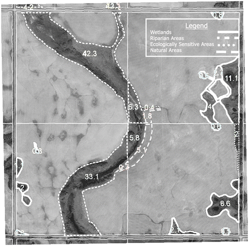
Eligible wetland areas were identified using Landsat imagery, orthophotography and the wetland classification scheme defined by Stewart and Kantrud (Citation1971). Specific coordinates for the eligible acres were recorded in a geographic information system (GIS) database. A general verification of the eligible acres was conducted using identified data layers and acreage measurements of orthophotos, which were subject to an audit via random field inspections, covering 80% of landowner applications. Figure provides an example of area measurements for one quarter section (160 acres) in Blanshard. The specific quarter section in Figure contained 34.7 acres of wetlands, of which 23.6 were eligible for wetland service payment within ALUS.
Figure 1. This orthophoto shows a sample measurement of wetlands, riparian, natural and ecologically sensitive areas. Their size is indicated by the superimposed white units.
ALUS is just one means of designing and delivering programs for EG&S to rural landowners and farmers. The intent of this research is to undertake an isolated analysis of ALUS in Blanshard, not to conduct a comprehensive comparison of ALUS to alternative approaches.
Empirical methods
The empirical methods used to determine whether ALUS achieved preservation and enhancement of wetlands are divided into two parts. Part 1 is a survey, which examines the acceptance and participation of landowners in ALUS’s wetland services program. Part 2 is an agri-environmental footprint index (AFI) assessment of the environmental impact of ALUS.
Part 1: Participation in ALUS
The first part of the analysis of ALUS is an investigation of the extent of landowner interest and participation in the program. This is important because an agri-environmental program cannot be effective for preservation and enhancement of EG&S without garnering acceptance and participation from landowners. In Blanshard, this was especially important because half of all landowners had never participated in an environmental or conservation program prior to ALUS. This is higher than the national average of 35% (Environics Research Group [ERG] Citation2006). The extent of acceptance and participation was analyzed using enrolment data, as well as responses to surveys of participant landowners administered in both year 1 and year 2 of ALUS.
Survey questions asked Blanshard landowners about their knowledge of and attitude toward EG&S in their locality, and their willingness to respond to EG&S payment schedules. Every landowner in Blanshard was surveyed at the beginning of year 2. Follow-up surveys were conducted at the end of year 2 to assess any change in knowledge and attitude over that year. Landowners from neighbouring RMs where ALUS was not offered were also surveyed at the beginning of year 2. This was to facilitate the assessment of whether direct access to ALUS had an impact on Blanshard landowners’ EG&S knowledge and attitude relative to landowners from non-participating RMs.
Part 2: Agri-environmental footprint (AFI) index assessment
This part of the analysis involves the AFI. The AFI was developed to evaluate the effectiveness of agri-environmental programs in the European Union (EU) (Mauchline et al. Citation2007a). The European Environment Agency (Citation2005, 2006) and the Organisation for Economic Co-Operation and Development (OECD) (Citation2001, Citation2007) describe the AFI as a means to simplify complex and intertwined information by incorporating farm-level environmental indicators into an index. The AFI measures the change in the environmental impact of parcels of land as a response to environmental programs. The AFI is calculated using indicators from three agri-environmental dimensions: natural resources, biodiversity and landscape. The AFI has been implemented in 14 different case studies in the EU (Mauchline et al. Citation2007b, Citation2012). This study is the first to employ the AFI outside the EU.
The AFI method is an eight-step process, and is described in detail in the AFI users’ manual (Mortimer Citation2008). The steps are summarized as follows:
Define the scope of the AFI application, including types of land uses to be assessed and comparisons to be made, geographical region and sampling strategy.
Identify assessment criteria specific to the environmental program under investigation by creating an assessment criteria matrix that identifies the relevant agri-environmental issues, as well as the ecological management foci that can be used to deal with the issues. Three ecological management foci were used in the AFI assessments conducted in the EU: crop and animal husbandry, physical farm infrastructure, and natural and cultural heritage.
Assign weights based on their relative importance to the agri-environmental dimensions (We) and ecological management foci (Wf) of the AFI such that ΣWe = 100% and ΣWf = 100%.
Identify multiple farm-level indicators for each AFI dimension in the assessment criteria matrix. Mauchline et al. (Citation2007a) recommend that each AFI dimension have between one and five indicators, and that the total number of indicators for the matrix does not exceed 25.
Collect data for the indicators using surveys and high-definition aerial photography.
Standardize the indicator values on a scale ranging from 0 to 10. For example, binary indicators that are either “no” or “yes”, could be standardized to “no” = 0 and “yes” = 10. For a detailed discussion on standardizing categorical indicators, see Purvis et al. (Citation2009).
Based on their relative importance, assign weights to the indicators such that ΣWi = 100% within each AFI dimension.
Calculate the AFI by multiplying the standardized indicator values (Ii) with corresponding weights, and summing at each level. The mathematical representation of the AFI is:
(1)
The application of the AFI process to ALUS in Blanshard was reviewed by one of the primary developers of the AFI, who travelled to Blanshard to observe the process. First, orthophoto maps were used to make comparisons between two sets of 11 quarter sections (22 in total), one in which landowners were participating in ALUS and the other for those who were not. Quarter sections were defined as participating in ALUS based on the following criteria: no less than 15% of land enrolled in the program, and no less than two services (e.g. wetlands, natural areas, etc.) enrolled in the program. Non-participating quarter sections were those with no less than 15% of land eligible for ALUS, and no less than two services eligible for ALUS but not enrolled. The 22 quarter sections were randomly selected and represented 10% of all quarter sections in Blanshard.
Next, the assessment criteria were developed by facilitated roundtable discussions with the technical advisory committee, accounting for agri-environmental issues specific to ALUS principles. The resulting agri-environmental issues specific to ALUS are listed in Table .
Table 1. The agri-environmental footprint index (AFI) indicator matrix, specific to the Alternative Land Use Services program (ALUS), captures three agri-environmental dimensions: natural resources, biodiversity and landscape.
Then, each member of the technical advisory committee independently assigned weights to the AFI dimensions (natural resources, biodiversity and landscape) and to the ecological management foci (crop and animal husbandry, physical farm infrastructure, and natural and cultural heritage). Aggregate weights were determined from the mean, after dropping the highest and lowest values. The aggregate weights are listed in Figure .
Figure 2. The detailed agri-environmental footprint index (AFI) assessment criteria matrix specific to the Alternative Land Use Services program (ALUS) indicates the weights assigned to agri-environmental AFI dimension (We), ecological management foci (Wf) and indicators (Wi).
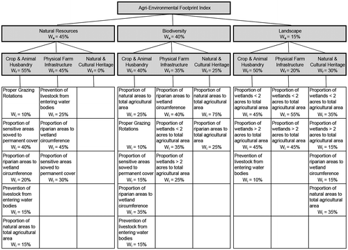
Next, indicators for each AFI dimension were developed by facilitated roundtable discussions with program stakeholders and the technical advisory committee, and are listed in Figure . When developing the indicators, the committee took into account previous EU AFI assessments, emphasizing the importance of having quantitative indicators that were measurable using orthophotos. Each AFI dimension was assigned one to five indicators, with the number of indicators for the entire matrix being less than 25. The same indicator can be used for multiple AFI dimensions, but weights will vary based on importance for the specific dimension (Purvis et al. Citation2009). The finalized indicators with corresponding weights (Wi) are listed in Figure , having been determined in the same fashion as the weights, We and Wf.
Finally, quarter sections were drawn randomly from a list of all quarter sections in Blanshard. If the quarter section was not classified as either a participating quarter section or a non-participating quarter section as per the criteria set forth in the first step, it was discarded and a new quarter section was drawn. The indicators for each AFI dimension were given a score based on orthophotos, with measurements and coordinates stored in a GIS database. Scores were based on proportions, which were multiplied by 10 to convert to the standardized scale and then entered into the matrix shown in Figure . A unique AFI for each of the 22 quarter sections was calculated using Equation (1).
Results and discussion
Part 1: Participation in the ALUS program
In the first year of ALUS (2006), 14,625 acres of wetlands were enrolled by Blanshard landowners (Table ). Wetlands enrolled in the “no agricultural use” category dominated the other categories. Additionally, ALUS resulted in a higher enrolment of large wetlands than small wetlands. There were 168 contracts signed from a possible 225 landowners, representing a 75% program participation rate. In the second year of ALUS (2007), 14,709 acres of wetlands were enrolled by landowners from Blanshard. There were 163 contracts signed from a possible 225 landowners, for a 72% participation rate. Total payments to landowners in Blanshard for contracted wetland services under ALUS amounted to $199,628 in 2006, and $205,662 in 2007 (Table ).
Table 2. Blanshard: wetland enrolment.
Table 3. Blanshard: wetland payments (CAD$).
In January 2007, a 53-question survey was mailed to each of the 225 landowners in Blanshard. Questions were posed in language familiar to the respondents to minimize misinterpretation, and definitions of terms were provided for clarification. The survey questions were designed with the assistance of the technical advisory committee and tested beforehand on a group of 10 landowners. Several questions from the National survey of farmers and ranchers: Ecological goods and services (ERG 2006) were posed to enable a comparison with regional responses. Tables and contain the specific questions, rationale and results. The remaining survey questions and aggregated results are available from the authors upon request. Landowners were given the option of completing the survey by mail, by telephone or in person. Two surveys were returned unopened, leaving a possible 223 surveys to be completed. Ninety-three surveys were completed and returned by mail, and five surveys were completed in person or by telephone, giving a total of 98 responses, a response rate of 44%. Four landowners requested an interview in addition to completing the survey.
Table 4. Blanshard and adjacent landowner survey results: Year 1.
Table 5. Blanshard landowner survey results: Year 2.
In February 2007, ALUS surveys were sent to a random sample of 24 landowners from each of four RMs adjacent to Blanshard: Strathclair, Hamiota, Saskatchewan and Harrison. These 24 landowners represented 10% of the landowner population in the adjacent RMs. The surveys were identical to those sent to Blanshard landowners, except landowners outside Blanshard were given only the option to complete the survey by mail. Of the 96 surveys sent to the four municipalities, eight were returned unopened, leaving a possible 88 surveys to be completed. Thirty-one were completed and returned by mail and, despite not being formally presented with the option, one was completed over the telephone, giving a total of 32 responses for a response rate of 36%.
In October 2007, a second survey containing 27 questions was sent to each of the 98 Blanshard landowners who responded to the first survey. Two surveys were returned unopened, leaving a possible 96 surveys to be completed. In total, 52 surveys were completed resulting in a response rate of 54%.
Discussion: Part 1
ALUS garnered the acceptance and uptake of landowners in Blanshard, shown by the landowners’ willingness to participate. Enrolment exceeded 70% of the landowners in both years 1 and 2, and the enrolment was particularly high for wetland services. The area of wetlands enrolled in ALUS was more than twice that of the natural, sensitive and riparian areas combined. Enrolment levels this high can be viewed as significant, especially in light of the fact that more than half of the landowners in Blanshard had not participated in any ecological or conservation program in the past.
The enrolment responses indicate that ALUS’s technical advisory committee had a reasonable sense of required payment levels to procure wetlands in Blanshard. They effectively “made a market” for wetland services. The year 1 survey asked landowners to react to the offered payment schedule. A favourable response was recorded for 79, 58 and 48% of landowners for no agricultural use, haying and grazing, respectively. The year 2 survey asked landowners to explicitly state the payments required for wetlands. There was some bias introduced in the year 2 survey responses since the offered payment schedule was already known to the responding landowners. However, the process did provide an open forum to make their preferred payments known. Overall, the stated required payment levels were somewhat higher than the actual payments; desired payments were generally in the range of those offered for the no agricultural use category, but substantially higher than payments offered for the haying and grazing categories. These responses may indicate why the proportion of wetlands enrolled in no agricultural use dominated the other categories.
A second indicator of acceptance of ALUS was the willingness of landowners to participate in program evaluation, indicated by their willingness to respond to mailed surveys. The response rates from Blanshard landowners on the extensive year 1 survey, and on the somewhat shorter year 2 survey, were strong at 44% and 54%. The response rate to the surveys in neighbouring RMs was also strong at 36%, so ALUS may have heightened interest in agri-environmental issues sufficiently to spill over to adjacent regions. Most surveys were completed fully or nearly fully, and many included helpful observations, comments and suggestions, further indicating the level of interest in ALUS.
ALUS resulted in higher enrolment in some wetland categories than others. For example, enrolment in haying and grazing was lower than in no agricultural use. These varied enrolments may have been influenced by price, since no agricultural use was paid $15.00 per acre, compared to haying ($7.50/acre) and grazing ($5.00/acre). Haying and grazing payments were perhaps discounted too much relative to no agricultural use payments, considering that interruptions in the timing of haying and grazing can cause costly farm production inefficiencies. For example, the nutritional quality of forage depends on timely harvesting, which could be affected by an ALUS contract commitment. Also, reduced stocking rates for cattle on pasture due to an ALUS contract commitment could make it necessary for producers to have surplus pasture acres to accommodate grazing needs, perhaps at some distance and cost.
There was relatively higher enrolment of large wetlands in comparison to small wetlands. This is a concern because small wetlands provide important EG&S and are particularly at risk because they cause productive inefficiencies, and their size makes them relatively easy to drain. Additionally, landowners are hesitant to commit small wetlands because during dry years, small wetlands can become productive land and eliminate the production inefficiency caused by the nuisance of farm machinery having to skirt the wetlands. With payments based on the size of the wetland, it is uneconomical for landowners to commit very small wetlands. Note, however, that the supply of wetlands is affected by more than just the contract prices offered; agricultural commodity prices and program contract length are also factors in enrolling wetlands.
It is important, ecologically and for efficient administration, to see wetlands stay committed under contract for long periods of time. Survey responses from Blanshard and adjacent landowners indicate that program uptake will suffer if contract length moves beyond five years. With short contracts, there would be a risk to wetland services from non-renewal as contracts expire. Perhaps a re-signing bonus upon contract expiration could encourage landowners to maintain their wetland commitments. Such a re-signing bonus could achieve a balance between long-term commitment to EG&S and optimal contract length.
Part 2: AFI assessment
Summary statistics for the seven AFI indicators are shown in Table , and the AFI for each quarter section is shown in Table . The mean AFI of 6.632 for participating quarter sections was higher than the mean score of 5.419 for non-participating quarter sections. The standard deviations for the AFI scores were 0.635 and 0.492 for participating and non-participating quarter sections, respectively. This results in the mean AFI scores for participating quarter sections being higher than that for non-participating quarter sections, at a 5% level of significance using a Student’s t-test.
Table 6. Summary statistics for Alternative Land Use Services program (ALUS) participant and non-participant agri-environmental footprint index (AFI) indicators.
Table 7. Participant and non-participant agri-environmental footprint index (AFI).
The AFI result should be interpreted with caution because the data cover only the limited two-year period of ALUS. The result suggests a possible positive environmental response in Blanshard that may be attributable to ALUS. This positive environment response could be caused by land use changes promoted by ALUS that can be made by landowners almost immediately, such as modifying grazing rotations, building fences to prevent livestock from entering water bodies and choosing not to drain small wetlands. The positive environmental response from the AFI is supported by results from the year 2 survey that find ALUS to have impacted the land use decisions for 58% of Blanshard landowners. However, the positive response in Blanshard could also be caused by a negative correlation between the AFI of an individual quarter section and agricultural productivity, resulting in selection bias towards lands of higher environmental quality entering the program. To determine whether a positive response can be attributed to ALUS, the AFI assessment should be repeated on an annual basis, and extended to include quarter sections from neighbouring RMs in which ALUS is not offered.
The 22 orthophoto maps that detail the location and size of the natural features provided by each of the 22 quarter sections link to a database that stores the coordinates and area for each feature. These data can be used as a baseline to track the provision of wetland services over time.
Discussion: Part 2
The AFI assessment suggests that the continuous annual payments offered for specific land management practices through ALUS may have a positive environmental impact by encouraging the maintenance and enhancement of wetlands in Blanshard. However, the data from ALUS cover only the limited two-year period. It is recommended that the baseline data be turned into a time series containing data on the provision of EG&S so that Blanshard would have a record of its environmental assets, which will be valuable in quantifying the effects of current and future environmental programs, including the return of ALUS to Blanshard (Arnason Citation2014).
Conclusions
This research addresses the question of whether the ALUS program in Blanshard achieved preservation and enhancement of wetlands controlled by rural landowners. The ex post assessment found that ALUS, though short lived, showed early effectiveness as a method of preserving and enhancing wetlands. The extent of acceptance and participation by landowners in Blanshard was analyzed using enrolment data and responses to landowner surveys that were administered in both year 1 and year 2 of ALUS. The ALUS effects on parcels of land were measured by an AFI assessment. This research was the first to apply the AFI outside of the EU.
Four outcomes can be drawn from this research, each of which could assist future programs of a similar nature: (1) the importance of acceptable pricing of EG&S, (2) the importance of acceptable contract length, (3) the importance of the involvement of local landowners in the development and implementation of the program, and (4) the importance of a method of measuring results. Meeting each of these four conditions was central in helping garner interest and participation by landowners in ALUS, and should be considered in the design of future programs.
Acknowledgements
Special thanks to the anonymous reviewers and the Special Issue co-editors, Diane Dupont and Marian Weber, for comments and suggestions. The research described in this paper was supported by funding from the Manitoba Rural Adaptation Council.
References
- Arnason, R. 2014. ALUS program re-introduced in Manitoba. The Western Producer, 26 May. http://www.producer.com/daily/alus-program-re-introduced-in-manitoba/ (accessed July, 2014).
- Environics Research Group (ERG). 2006. National survey of farmers and ranchers: Ecological goods and services. Prepared for: Wildlife Habitat Canada.
- European Environment Agency. 2005. Agriculture and environment in EU-15 – The IRENA indicator report. EEA Report 6/2005. Copenhagen: European Environment Agency.
- European Environment Agency. 2006. Integration of environment into EU agriculture policy – the IRENA indicator-based assessment report. EEA Report 2/2006. Copenhagen: European Environment Agency.
- Mauchline, A. L., J. R. Park, J. A. Finn, and S. R. Mortimer. 2007a. The Agri-Environmental Footprint Index. Aspects of Applied Biology 81: 263–266.
- Mauchline, A. L., J. R. Park, J. A. Finn, and S. R. Mortimer. 2007b. Measuring environmental performance and value added using the Agri-Environmental Footprint Index. In Proceedings of the 16th International Farm Management Association Congress, 706–711, Cork, Ireland. http://www.ifmaonline.org/pages/con_articles.php?article=5
- Mauchline, A. L., S. R. Mortimer, J. R. Park, J. A. Finn, K. Haysom, D. B. Westbury, G. Purvis, et al. 2012. Environmental evaluation of agri-environment schemes using participatory approaches: Experiences of testing the Agri-Environmental Footprint Index. Land Use Policy 29: 317–328.10.1016/j.landusepol.2011.07.002
- Mortimer, S. R., ed. 2008. The Agri-Environmental Footprint Index users’ manual. http://www.footprint.rdg.ac.uk/ (accessed July, 2014).
- Organisation for Economic Co-operation and Development (OECD). 2001. Key environmental indicators for agriculture: Methods and results. vol. 2. Paris, France: OECD Publishing.
- Organisation for Economic Co-operation and Development (OECD). 2007. Key environmental indicators. Paris, France: Environment Directorate.
- Purvis, G, G. Louwagie, G. Northey, S. Mortimer, J. Park, A. Mauchline, J. Finn, et al. 2009. Conceptual development of a harmonised method for tracking change and evaluating policy in the agri-environment: The Agri-Environmental Footprint Index. Environmental Science and Policy 12: 321–337.10.1016/j.envsci.2009.01.005
- Stewart, R. E., and H. A. Kantrud. 1971. Classification of natural ponds and lakes in the glaciated Prairie region. Resource Publication 92, Bureau of Sport Fisheries and Wildlife. Washington, DC: U.S. Fish and Wildlife Service, 57 pp.