
Abstract
Following from Parts I and II of this series (this issue), some common approaches for developing and assessing future scenarios of water availability are reviewed, along with recent case studies of Canadian watersheds. The results of future changes in drought related to climate change are influenced by the choice of indicators. For the Standardized Precipitation Index (SPI), small changes in drought frequency and severity are projected over southern Canada, reflecting the influence of increases in future annual precipitation only. However, assessments using the Palmer Drought Severity Index (PDSI) reveal dramatic increases in the potential for future droughts since this indicator incorporates the combined influences of higher temperatures, soil moisture capacity and precipitation to estimate evapotranspiration. Regarding projected changes in runoff, watersheds in British Columbia tend to show increases in annual and winter runoff. Some watersheds show projected decreases in summer runoff. In the southern Prairies, most watersheds show projected decreases in annual and summer runoff. In Ontario and Quebec, results are mixed. Lake levels in the Great Lakes are projected to decline under most scenarios, but results differ between regional and global climate model-based scenarios due to differences in how lake evaporation is calculated. In New Brunswick, Labrador and northern Quebec, streamflow is projected to increase. Uncertainties in future projections emerge due to differences between climate scenario generating methods, and between hydrologic models used for the assessments. This paper concludes with some thoughts on addressing important research questions related to future scenarios of water availability in Canada. For scenario-based assessments, hydrologic model inter-comparisons might yield some useful insights into uncertainties in model structure that affect evaporation, evapotranspiration and snowmelt calculations. Scenarios developed for assessments should include both future climate and projected land use/cover changes and, where necessary, integration of potential reduction in glacier volume. Finally, as scenarios from regional climate models become more readily available, there may be more opportunity to explore how runoff projections could be applied to basin-scale routing models.
À la suite des parties I et II de cette série, des méthodes d’élaboration et d'évaluation de futurs scénarios concernant la disponibilité de l'eau seront examinées, ainsi que des études de cas portant sur les bassins versants du Canada. Les résultats des futurs changements des conditions de sécheresse liés aux changements climatiques sont influencés par le choix des indicateurs. Pour l’indice de précipitation standardisé (SPI), des changements mineurs liés à la fréquence et la gravité des sécheresses sont prévus dans le sud du Canada, indiquant l’influence de l’augmentation des futures précipitations annuelles seulement. Cependant, les évaluations utilisant l’indice de sévérité de sécheresse de Palmer (ISSP) révèlent une augmentation considérable des possibilités de sécheresses à l’avenir, étant donné que cet indicateur intègre les influences combinées de températures plus élevées, la capacité d’humidité du sol et les précipitations pour estimer l’évapotranspiration. En ce qui concerne les changements prévus du ruissellement, les bassins versants de la Colombie-Britannique ont tendance à afficher une augmentation des ruissellements annuels et hivernaux. Une diminution du ruissellement estival est prévue sur certains bassins versants. Dans le sud des Prairies, une diminution prévue des ruissellements annuels et estivaux pour la plupart des bassins versants. En Ontario et au Québec, les résultats sont variables. On prévoit que le niveau d’eau dans des Grands Lacs diminue dans la plupart des scénarios, mais les résultats diffèrent entre les scénarios fondés sur le modèle climatique mondial et ceux fondés sur le modèle climatique régional, en raison des différentes manières de calculer l’évaporation. Au Nouveau-Brunswick, au Labrador et au Québec, l’écoulement fluvial devrait augmenter. Des incertitudes dans les prévisions futures sont attribuables aux différences entre les méthodes utilisées pour générer des scénarios relatifs au climat et entre les modèles hydrologiques utilisés aux fins d’évaluations. Nous terminons par une réflexion sur le traitement de questions importantes en matière de recherche quant aux scénarios futurs sur la disponibilité de l’eau au Canada. Pour les évaluations fondées sur des scénarios, l’intercomparaison de modèles hydrologiques pourrait offrir un aperçu utile des incertitudes dans la structure des modèles qui touchent les calculs de l’évaporation, de l’évapotranspiration et de la fonte des neiges. Les scénarios élaborés aux fins d’évaluation doivent comprendre les futurs changements climatiques et les futurs changements relatifs à l’utilisation des terres ou à la couverture terrestre, et, au besoin, l’intégration d'une diminution potentielle du volume des glaciers. Enfin, étant donné que les scénarios tirés de modèles climatiques régionaux sont disponibles plus rapidement, il peut y avoir davantage de possibilités visant à explorer la manière dont les prévisions relatives au ruissellement pourraient s’appliquer aux modèles de laminage à l’échelle des bassins.
Introduction
Future water availability challenges in Canada may be exacerbated by anthropogenic climate change and variability, since an underlying assumption has been stationarity (Environment Canada Citation2004; Milly et al. Citation2008; Council of Canadian Academies 2013). Anthropogenic climate change due to increasing concentrations of greenhouse gases (GHG) can lead to impacts on freshwater systems, including changes in extremes (droughts, floods), changes in storage capacity of the cryosphere (snowpack, glaciers) and alterations in seasonal cycles (Bates et al. Citation2008).
Following the discussion on indicators (Koshida et al. Citation2015) and historical trends (Mortsch et al. Citation2015), Part III of this three-part synthesis of recent literature focuses on future scenarios of water availability in Canada. Some common approaches for developing and assessing future scenarios of water availability and reports on emerging potential trends and impacts are reviewed. This includes a comparison of cases incorporating climate-based indicators, hydrologic models and scenarios based on regional- and global-scale climate models. The paper concludes by outlining a way forward for addressing important research questions related to future scenarios of water availability in Canada. As noted in Parts I and II, this review does not include groundwater. Given the importance of groundwater throughout Canada, and the emergence of some new literature (e.g. Allen et al. Citation2010), such a review is certainly warranted.
Climate models and scenarios
Most climate change impact studies have used scenarios based on model results from one or more of the atmosphere–ocean general circulation model (AOGCM) experiments based on scenarios from the SRES (IPCC Special Report on Emission Scenarios) series of future changes in GHG emissions (Nakićenović and Swart Citation2000). Scenario projections of temperature (T), precipitation (P) and other indicators (such as snow water equivalent [SWE]) are generally provided as differences between a future time period, usually 2041–2070 (the 2050s) or 2071–2100 (the 2080s), and a baseline period. Studies have used different baseline periods, with most choosing 1961–1990, while other periods (e.g. 1980–1999) may be selected depending on the availability of historical records in each case.
Some cases use scenarios obtained from regional climate models (RCM), which are dynamically downscaled finer resolution simulations which use AOGCMs outputs as a boundary condition for simulations of climate over a more detailed landscape. A review of AOGCMs and RCMs can be found in Flato et al. (Citation2013). Hewitson et al. (Citation2014) provide a review of the application of climate models for constructing regional scenarios.
Scenarios from climate models have been used as input to basin-scale and global-scale hydrologic models, so that projections of atmospheric parameters can be translated into hydrologic indicators of water availability, including surface runoff and groundwater (Bates et al. Citation2008). Scenario-based case studies have been carried out for watersheds throughout Canada, some using AOGCM outputs, while others have used different combinations of AOGCMs and RCMs. A list of climate models used in case studies in Canada is provided in Table . The primary output has been annual or seasonal runoff.
Table 1. List of climate models, and respective modeling centre and country.
There have also been studies of future scenarios of climatic indicators, particularly future drought occurrence. Climatic indicators include potential evapotranspiration (PET), the Climate Moisture Index (CMI), the Palmer Drought Severity Index (PDSI) and the Standardized Precipitation Index (SPI). These indicators are reviewed in Part I (Koshida et al. Citation2015). Scenario-based studies using these kinds of indicators can provide information on potential changes in future drought risk.
New climate scenarios, based on new emission scenarios known as representative concentration pathways (RCP), are now available (van Vuuren et al. Citation2011, Citation2012), so there will be interest in seeing how these compare to the previous generation of scenarios. One early example is included below.
Climate-based indicators
Following the discussion in Parts I and II (Koshida et al. Citation2015; Mortsch et al. Citation2015), projections of changes in drought occurrence are first considered. Several case studies have calculated changes in climate-based indicators for the Prairie Provinces, or southern Canada. Table lists the climate models and drought indices used for projections under various climate change scenarios.
Table 2. Drought indices and climate models chosen for projections of drought occurrence for climate change scenarios, listed by reference.
Barrow (Citation2010) calculated the 1971–2000 and 2041–2070 mean PET fields for the Canadian Prairies using both the Thornthwaite and simplified Penman–Monteith methods. The Thornthwaite method produces larger PET totals (500–600 mm) than those of the Penman–Monteith (300–400 mm). PET is greater in the 2041–2070 period, with larger projected PET increases occurring using the Penman–Monteith method (200 mm) compared with the Thornthwaite method (100 mm). This is likely driven by the inclusion of maximum temperature in the Penman–Monteith method.
The CMI, based on P – PET, was calculated for both the water year (October–September) and for the summer period (May–July). For the 2041–2070 period, CRCM and HRM3 (see Table ) show increases in both intensity and area of moisture deficit. RCM3 shows no areas of deficit in annual moisture. For the 2041–2070 period, CMI increases by about 200 mm, resulting in a range of 200–400 mm, and 400–600 mm in the south.
Bonsal and Regier (Citation2006) conducted a preliminary assessment of future drought occurrence over southern Canada for the 2041–2070 period. Indicators used were the SPI and PDSI. There were only small positive changes in the SPI values for the agricultural year (September–August) over all of southern Canada for the majority of climate change scenarios, reflecting a projected increase in future annual precipitation over most of southern Canada. However, the projections for PDSI revealed dramatic increases in the potential for future droughts, particularly in the warm–dry scenario (Bonsal and Regier Citation2006; Bonsal et al. Citation2011). Differences between the SPI and PDSI projections can be attributed to the inclusion of temperature in the PDSI calculations.
Bonsal et al. (Citation2012) assessed changes to the temporal and spatial characteristics of future (2011–2100) PDSI and SPI values using statistically downscaled daily temperature and precipitation data over the southern Canadian Prairies from three AOGCMs with different GHG emission scenarios. The future mean PDSI estimates indicate the prevalence of more persistent negative values, particularly after 2040, with few positive PDSI values after this date. This suggests a regime shift to a more arid climate in the southern Prairies, and reflects the effects of projected summer temperature increases. However, the mean future SPI time series does not exhibit a dramatic change from the SPI calculated from instrumental observations, and there is no significant trend towards negative SPI values over the 2011–2100 projection period.
Future PDSI reveals considerably longer droughts than observed in the historical instrumental record (8.4 vs. 2.4 seasons), whereas future SPI indicates drought duration slightly decreasing in the future (1.8 vs. 2.0 seasons). Future projections of PDSI also indicate that multi-year droughts of 10+ years are also more likely than their occurrence in the paleo or instrumental records (3.1 per 100 years vs. 1.0–1.1 per 100 years). This suggests that twentieth-century extended drought conditions may have been relatively benign and that droughts of longer duration are likely to return (and become further extended in duration) in the twenty-first century. This is consistent with the findings of others; for example, Trenberth (Citation2011) used several AOGCM simulations to show that increased warming in the future leads to greater evaporation and surface drying, thereby increasing the intensity and duration of drought, particularly in the summer over continental interior regions of North America.
Dai (Citation2012) determined how PDSI might change in the future under intermediate future GHG emissions scenarios from the Coupled Model Intercomparison Project phase 5 (CMIP5), incorporating one of the new RCP emission scenarios. For RCP4.5, a scenario of moderate emissions increase, severe to extreme drought conditions were projected for 2080–2099 for much of southern Canada, including southeast British Columbia, the Prairies and Ontario, as well as much of the United States.
Drought severity for 3-month (DRO3), 6-month (DRO6) and 10-month (DRO10) durations for the Canadian Prairies were simulated with the CRCM for the A2 scenario, 2041–2070 period (PaiMazumder et al. Citation2012). These are based on drought severity indices obtained from accumulated monthly precipitation deficits, using 1971–2000 reference climatology. DRO6 and DRO10 events are projected to become more severe over southern Manitoba and Saskatchewan and the eastern slopes of the Rocky Mountains. The frequency of DRO10 type events for the 2041–2070 period is projected to increase by up to four events, compared with 1971–2000. In northern areas of the Prairies, DRO6 and DRO10 are projected to be less severe and less frequent, but DRO3 events are projected to become more severe.
Runoff and streamflow
There have been many case studies published since the previous national assessment (Lemmen et al. Citation2008) of the impact of projected scenarios of climate change on various watersheds throughout Canada, particularly in the west. As these are projections, the case study results are obtained from hydrologic model simulations of runoff or streamflow, rather than analyses based on observations of climate (temperature, precipitation) or streamflow. Results are compared with model simulations of a base case using historical climate data.
A comparison of some recent (2008–2013) case studies of projected changes in runoff, streamflow or similar indicators, for various watersheds in Canada, is provided in Table and Figure . Table lists hydrologic models and climate models used for scenario-based studies included in this review.
Table 3. Projected change in hydrologic indicators from basin-scale case studies, 2050s, compared with 1961–1990 or 1980–1999 baseline periods, median or range of median projections, unless otherwise indicated. Watersheds listed from western to eastern Canada. (Sources and models listed in Table .)
Figure 1. Projected changes in hydrologic indicators (from Table ). Adapted and updated from Bush et al. (Citation2014).
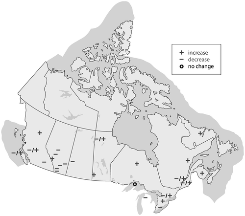
Watersheds in British Columbia tended to show projected increases in annual and winter runoff, with earlier onset of the spring freshet. Some watersheds did show projected decreases in summer runoff. There was generally a wider range of projected runoff volumes between AOGCMs than between GHG emission scenarios, suggesting greater sensitivity to inter-model differences than differences in emission scenarios (Schnorbus et al. Citation2011, Citation2014; Kerkhoven and Gan Citation2011; Bennett et al. Citation2012; Shrestha et al. Citation2012b). Within the Rocky and Columbia Mountains regions, short-term increases in glacier melt would result in a lengthening of the melt season, which would moderate the decrease of summer streamflow relative to projected shorter term trends. In the longer term, however, it would be important to incorporate continued glacial retreat into scenario projections as ice volumes and corresponding melt volumes decline (Stahl et al. Citation2008; Bürger et al. Citation2011; Jost et al. Citation2012; see below). Forest cover loss due to mountain pine beetle (MPB) infestation could lead to short-term increases in streamflow, offsetting other climate change impacts, until new forest cover is re-established (Harma et al. Citation2012).
In the Prairies, most watersheds in Alberta and Saskatchewan showed projected decreases in both annual and summer runoff (Lapp et al. Citation2009; Shepherd et al. Citation2010; Forbes et al. Citation2011; Kerkhoven and Gan Citation2011; Stantec Citation2012; Tanzeeba and Gan Citation2012; St. Jacques et al. Citation2013). One exception was the Cline River, within the North Saskatchewan Basin in Alberta, in which annual, winter and spring streamflow were projected to increase due to projected increases in winter and spring rainfall (Kienzle et al. Citation2012). Increases were projected for the Upper Assiniboine and Morris Rivers in southern Manitoba. The application of different transfer methods (delta-change, bias correction) to various RCMs did not affect the direction of projected streamflow changes (Shrestha et al. Citation2012a). In other cases, however, divergence in the direction of projected outcomes did occur because of differences in assessment methods. Shepherd et al. (Citation2010) obtained different winter and annual flow projections for the Oldman River when comparing empirical trend projection and hydrologic modelling. Bohrn (Citation2012) obtained opposite changes for the Churchill River when comparing outputs from three different hydrologic models using the same climate scenario (see below).
In Ontario (Grillakis et al. Citation2011) and Quebec (Quilbé et al. Citation2008; Boyer et al. Citation2010; Chen et al. Citation2011), results for projected annual runoff or streamflow were mixed. In New Brunswick (El-Jabi et al. Citation2013) and Labrador (Roberts et al. Citation2012), annual streamflow was projected to increase.
Most of these cases did not report runoff outputs generated directly by the climate models. One exception is Shrestha et al. (Citation2011) who compared scenario projections using the VIC (variable infiltration capacity) model with runoff outputs from CGCM3-CRCM for the Peace and Upper Columbia watersheds. The VIC cumulative runoff outputs for the 1961–1990 baseline period were <5% below observations, while the direct cumulative runoff from climate model outputs were >10% below observations as they were not calibrated to observations.
The application of different hydrologic models to projected changes in temperature and precipitation may influence cross-basin comparisons. A review of hydrologic models used in studies in British Columbia and Alberta illustrate the wide range of model complexity and functionality, and the challenges associated with using these models for answering climate change questions at watershed scales (Beckers et al. Citation2009). However, this review did not include a control test, such as an inter-comparison of hydrologic model outputs for the same set of scenarios in the same study sites, so the extent to which variations in hydrologic model design influences projections of future water availability is not clear.
It would be instructive to see the range of simulated outcomes due to variations in hydrologic model design, compared with ranges due to differences in GHG emission scenarios and climate model projections. A case study of the Ceizur River basin (in Gatineau River watershed, Quebec) compared a lumped conceptual model, HSAMI, and a distributed physically based model, HYDROTEL, under both historical and future scenario conditions. Results showed that HSAMI had consistently higher SWE and lower groundwater content than HYDROTEL, indicating that hydrological model uncertainty was more significant than the effect of calibration parameter uncertainty (Poulin et al. Citation2011). Differences between hydrologic models were also obtained in another Quebec case study, Manicouagan, also using HSAMI and HYDROTEL, as well as HMETS, another lumped conceptual rainfall-runoff model (Chen et al. Citation2011). These cases, along with the Churchill River case discussed earlier (Bohrn Citation2012), and a recent study of the Au Saumon catchment in Quebec (Velázquez et al. Citation2013), raise questions about the relative uncertainty of hydrologic models and climate scenarios (from climate models and emission scenarios) in projections of future streamflows and water availability. The literature offers many examples of studies that use multiple climate scenarios but only one hydrologic model, which serve as a test of climate scenario uncertainty. What about hydrologic model uncertainty?
Regarding the application of climate model outputs, another question concerns differences due to downscaling. Quilbé et al. (Citation2008) compared the classical delta method, statistical downscaling, and a combination in a case study of the Chaudière River, Quebec. Results showed that statistical downscaling was better able to assess climate change effects on spring peak and summer low flows because of improved prediction of precipitation. Bourdin et al. (Citation2012) indicated that statistical downscaling approaches have been more popular because of less demanding computational requirements, and that, in practice, removal of bias in RCM outputs has hampered their applicability for regional-scale climate change impact assessment.
In the Manicouagan case, Chen et al. (Citation2011) compared uncertainties due to emission scenarios, AOGCMs, downscaling techniques, hydrologic models and hydrologic calibration parameters, and found that the choice of AOGCM was consistently the first or second most important source of uncertainty for projected changes in hydrologic variables. Choice of downscaling method was the next most important. However, in the Churchill case, Bohrn (Citation2012) found significant differences in projected streamflow between HBV-EC (Table ) and the other two hydrologic models tested, WATFLOOD and HMETS.
Table 4. Hydrologic models and climate models chosen for projections of runoff for climate change scenarios (from Table ), listed by reference, in alphabetical order.
Concurrent land cover/use change scenarios would also be relevant for scenario-based climate change impact studies, but these are rarely included (Bourdin et al. Citation2012). In the case study of Trepanier watershed, Harma et al. (Citation2012) did include a scenario of forest cover reductions due to potential MPB infestation.
The separate calculations for observed “Actual Oldman” and reconstructed “Naturalized Oldman” rivers (St. Jacques et al. Citation2013) show different sensitivities to the climate change scenarios. In this case, future impacts were assessed using a regression model constructed from observed flow and observed climate patterns. The application of this climate-flow regression model to climate change scenarios is an alternative approach to applying one or more hydrologic models, which was the method chosen for other studies. Some studies used the VIC hydrologic model (e.g. Shrestha et al. Citation2012b) while others used HBV-EC (e.g. Jost et al. Citation2012), or a different model.
Most watersheds in Canada are influenced by snow accumulation and melt patterns. Maximum SWE is projected to decline in mid-latitude maritime regions (coastal British Columbia, Atlantic Provinces) and the Great Lakes–St. Lawrence region, while increases are projected for the Arctic coast of Nunavut (Brown and Mote Citation2009).
One basin-scale case study that focused on snow was that of Macdonald et al. (Citation2010), who modelled changes in mean annual snowpack for the St. Marys River, Alberta, using three climate change scenarios. The earlier onset of snowmelt, compared with observed present-day timing, has important implications since shifts in peak runoff to earlier in the spring or late winter may lead to decreased water availability later in the summer months. In this case, the mean date of maximum snowpack for the 1961–1990 period is 8 April. Both CGCM2 (A2) and NCAR-PCM (B2) scenarios indicate an earlier mean date of maximum SWE occurring by the 2080s on 2 April and 6 March, respectively.
Watersheds with large lakes and/or glaciers
Although the primary focus of this review has been on runoff or flow, lake level can also be an indicator of water availability, especially for watersheds dominated by large lakes, such as the Great Lakes. Projections of future lake levels necessitate the need to consider future changes in lake evaporation. This influences another key indicator used in Great Lakes research, net basin supply (NBS), which is the sum of runoff from land and P – E for the lake surface. Given the large size of each of the Great Lakes, relative to the total basin area for each lake, P – E for the lake surface is of particular importance.
In watersheds with large lakes, lake evaporation can have a significant influence on the annual water budget. Many studies of the Great Lakes have generally indicated projected decreases in median lake levels, including a recent study projecting lake level for Lake Michigan–Huron to change by –0.23 m by the 2050s (Angel and Kunkel Citation2010). However, Lofgren et al. (Citation2011) suggested that lake evaporation is a key uncertainty, and proposed that since projected lake evaporation has usually been based on air temperature as a proxy for PET, instead of PET obtained from an energy budget, projected lake level decreases from earlier studies may have been overestimated. However, long-term lake evaporation data sets are generally not available, and this hinders modelling. Monitoring of evaporation was initiated in 2008 under the International Upper Great Lakes Study and should address this knowledge gap.
Mackay and Seglenieks (Citation2013) applied a downscaled RCM specifically constructed for the Great Lakes (GLRCM) to the Coordinated Great Lakes Regulation and Routing Model (CGLRRM) to provide a new set of NBS and lake level scenarios. NBS estimates from CGCM3-GLRCM (A2) are included in Table . Using CGLRRM, projected changes in lake level for 2021–2050 are –3 cm for Lake Superior, –5 cm for Lakes Michigan–Huron and –6 cm for Lake Erie. Additional scenarios downscaled using other AOGCM-RCM combinations indicate near-zero changes in median lake levels accompanied by an increase in range. This result is very different from earlier studies (e.g. Mortsch et al. Citation2006; Angel and Kunkel Citation2010) using AOGCM-based scenarios, which projected larger declines in NBS and lake levels.
For watersheds that include glaciers, projected glacier retreat is expected to influence runoff, particularly during summer. Marshall et al. (Citation2011) assessed glacier runoff for 2000–2007, and future scenarios to 2100, for Rocky Mountain glaciers contributing to the Bow, Red Deer, North Saskatchewan, Athabasca and Peace rivers. Substantial declines are projected in the 2020s due to reduction in glacier volume. A change of –90% to –80% in regional glacier volume is estimated for the A1B and B1 scenarios by 2100. Examples of modelled glacier runoff changes between 2000 and 2050 (from Figure 9b of Marshall et al. Citation2011) include –80% for the North Saskatchewan River, –100% for Bow River, –75% for Peace River, and –60% for Athabasca River. As glacier runoff during 2000–2007 contributed around 7% to summer runoff in the Bow and North Saskatchewan Rivers, projected reductions would need to be accounted for in projections of streamflow during low-flow periods in summer and fall.
A way forward?
This review of recent Canadian literature shows that there has been considerable new work from 2008 to the present, in scenario-based projections of water availability indicators, particularly streamflow trends and runoff. However, much of this research has been concentrated in British Columbia, the Prairies, the North and Quebec. This review is offered as an inventory of current research, and of possible gaps that should be addressed for the benefit of users of this information.
Climate-based indicators for water availability are typically used for measuring drought frequency, severity, duration and extent. Much of the past work has focused on the Prairie Provinces, yet other regions of Canada are vulnerable to drought. It is possible to calculate both historical and future water budget data and drought indices such as PDSI, SPI (and SPEI) for climate stations across Canada as long as there is a complete monthly (or weekly) data set of temperature and precipitation data.
A common and important data gap is the lack of actual ET data. Different methods of calculating PET have been used in its place with varying results. Unfortunately, as was shown for the Great Lakes, uncertainty in our knowledge of evaporation and ET leads to uncertainty in projections of future water availability. There is an increased need for monitoring of evaporation.
Some streamflow trends have been linked with particular atmospheric oscillations, such as the Arctic Oscillation (AO), North Atlantic Oscillation (NAO), El Nino Southern Oscillation (ENSO) and Pacific Decadal Oscillation (PDO). A few studies have combined the detection of a monotonic trend (a climate change signal) with the influences of these atmospheric indices on variability for another approach to assessing hydrologic trends. So, how can this influence scenario-based study? Could such studies actually utilize, say, a PDO-type index from an AOGCM simulation as part of an impacts assessment of future runoff or streamflow? This would offer a parallel opportunity for impact studies as suggested for assessments of recent observed climate (Mortsch et al. Citation2015).
Most scenario-based studies have addressed potential climate uncertainty by estimating impacts over a range of climate change scenarios, including those downscaled with RCMs. What has not yet happened in a systematic way is a similar focus on hydrologic uncertainty. Almost every scenario-based study used multiple scenarios of climate change, but only one hydrologic model, with the exception of Chen et al. (Citation2011), Poulin et al. (Citation2011) and Bohrn (Citation2012). A hydrologic model inter-comparison might yield some useful insights, particularly considering the effects of model structural uncertainty which have led to differences in the representation of evaporation and snowmelt processes (Jiménez Cisneros et al. Citation2014). Scenarios should include both climate and land changes (Bourdin et al. Citation2012).
It also continues to be common practice for climate indicators from AOGCMs and RCMs to be used as inputs to hydrologic models for watershed-scale climate change impact studies. Runoff outputs from climate models are rarely used, as previous experience has not been very good; however, there continues to be interest in applying runoff data from an RCM as input to a river routing model to generate streamflow. This was done for a Quebec study, in which CRCM runoff data were applied to the WATROUTE river flow-routing model (Clavet-Gaumont et al. Citation2012). Perhaps there is an opportunity to explore how best to calibrate RCM runoff outputs at the watershed scale as a complement to current practice, as well as to the WaterMIP global-scale hydrologic modelling effort (Haddeland et al. Citation2011). The Great Lakes case, which used a customized RCM known as GLRCM, illustrates how this could be done (Mackay and Seglenieks Citation2013).
It is difficult to quantify the implications of observed and projected retreat of glaciers on streamflow. Within hydrologic models, it will be important to integrate glacier volume reductions with changes in other components of modelled streamflow (Jost et al. Citation2012), as part of scenario projections of future water availability. Glacier retreat could result in earlier melting and runoff of seasonal snow from sites that are presently glaciated (Marshall et al. Citation2011), and this would have broader implications for agricultural, industrial and residential water users in these watersheds (Schindler and Donahue Citation2006; Sandford Citation2012). However, rigorous modelling of coupled glacier mass balance and dynamics is challenging (e.g. Jarosch et al. Citation2010, 2013). Similarly, models will have to include other climate-related and hydrologically relevant land surface changes, such as shifts in vegetation presence and type.
SWE is also an important indicator of water availability, and continued development of remote sensing applications offers an important opportunity to augment surface monitoring, but a positive bias in AOGCM estimates of maximum SWE for most of Canada, particularly in high latitudes, still needs to be addressed (Brown and Mote Citation2009) as it could influence scenario projections of streamflow, especially potential changes in spring freshet.
Finally, it is important to consider that future population and income growth will lead to increasing demands for agriculture, water, land and other resources. These pressures will be set against a context of changing climate with high levels of associated uncertainty (Council of Canadian Academies Citation2013). Accessible information on projected climate impacts could contribute to future water resource management and planning. This review has illustrated recent efforts to assess future scenarios for various basins in Canada. There is a need to determine how best to archive this growing set of scenario-based projections of future water availability, for the benefit of water practitioners, planners, managers and decision makers.
Acknowledgements
We would like to thank Barrie Bonsal, Stephen Déry, Yonas Dibike, Sean Fleming, D.K. Kang, Monirul Mirza, Wendy Monk, Terry Prowse, René Roy, Blaise Gauvin St-Denis, Jeanine St. Jacques and Elaine Wheaton for their comments on earlier drafts of an unpublished report that was presented at the 2013 Canadian Meteorological and Oceanographic Society–Canadian Water Resources Association–Canadian Geophysical Union (CMOS–CWRA–CGU) Congress in Saskatoon, which has led to this series of papers. We would also like to thank Jenna Disch for assisting with tables and the reference list; Fiona Warren, Elizabeth Bush, Dong Young Lee and Adam Garbo for assisting with Figure ; and Kit Szeto, editor Diana Allen and the anonymous reviewers for comments on this series of papers. The opinions expressed here are those of the authors, and not necessarily those of Environment Canada.
References
- Allen, D. M., A. J. Cannon, M. W. Toews, and J. Scibek. 2010. Variability in simulated recharge using different GCMs. Water Resources Research 46: W00F03.
- Angel, J. R., and K. E. Kunkel. 2010. The response of Great Lakes water levels to future climate scenarios with an emphasis on Lake Michigan-Huron. Journal of Great Lakes Research 36(2): 51–58.
- Barrow, E. 2010. Hydroclimate data for the Prairies: An analysis of possibilities. http://www.parc.ca/rac/fileManagement/upload/Hydroclimate%20Data%20for%20the%20Prairies%20An%20analysis%20of%20Possibilities.PDF (accessed July, 2013).
- Bates, B. C., Z. W. Kundzewicz, S. Wu, and J. P. Palutikof, ed. 2008. Technical Paper of the Intergovernmental Panel on Climate Change. Climate Change and Water, 210 pp.
- Beckers, J., B. Smerdon, and M. Wilson. 2009. Review of hydrologic models for forest management and climate change applications in British Columbia and Alberta. FORREX Forum for research and extension in natural resources. Forrex Series 25. Kamloops, BC. 166 pp.
- Bennett, K. E., A. T. Werner, and M. Schnorbus. 2012. Uncertainties in hydrologic and climate change impact analyses in headwater basins of British Columbia. Journal of Climate 25(17): 5711–5730.
- Bohrn, S. K. 2012. Climate change impacts assessment and uncertainty analysis at the hydrology of a northern, data-sparse catchment using multiple hydrological models. Master’s thesis. Civil Engineering, University of Manitoba. Winnipeg, 207 pp. ( plus appendices). http://mspace.lib.umanitoba.ca//handle/1993/13692 (accessed July, 2014).
- Bonsal, B. R., R. Aider, P. Gachon, and S. Lapp. 2012. An assessment of Canadian prairie drought: Past, present, and future. Climate Dynamics 41(2): 501–516.
- Bonsal, B. R., and M. Regier. 2006. The 2001 and 2002 Canadian drought historical context and potential future occurrence. In Environment Canada Water Science and Technology Directorate Internal Rreport AE1-TN-06-002. Submitted to Natural Resources Canada, Climate Change Impacts and Adaptation Program, CCIAP A932, Government of Canada, Ottawa, 58 pp.
- Bonsal, B. R., E. E. Wheaton, A. C. Chipanshi, C. Lin, D. J. Sauchyn, and L. Wen. 2011. Drought research in Canada: A review. Atmosphere–Ocean 49(4): 303–319.
- Bourdin, D. R., S. W. Fleming, and R. B. Stull. 2012. Streamflow modelling: A primer on applications, approaches and challenges. Atmosphere–Ocean 50(4): 507–536.
- Boyer, C., D. Chaumont, I. Chartier, and A. G. Roy. 2010. Impact of climate change on the hydrology of St. Lawrence tributaries. Journal of Hydrology 384(1–2): 65–83.
- Brown, R. D., and P. W. Mote. 2009. The response of Northern Hemisphere snow cover to a changing climate. Journal of Climate 22(8): 2124–2145.
- Bürger, G., J. Schulla, and A. T. Werner. 2011. Estimates of future flow, including extremes, of the Columbia River headwaters. Water Resources Research 47(10): W10520.
- Bush, E. J., J. W. Loder, T. S. James, L. D. Mortsch, and S. J. Cohen. 2014. An overview of Canada’s changing climate. In Canada in a changing climate: Sector perspectives on impacts and adaptation, ed. F. J. Warren, and D. S. Lemmen, 23–64. Ottawa: Government of Canada.
- Chen, J., F. P. Brissette, A. Poulin, and R. Leconte. 2011. Overall uncertainty study of the hydrological impacts of climate change for a Canadian watershed. Water Resources Research 47(12): W12509.
- Clavet-Gaumont, J., L. Sushama, M. N. Khaliq, O. Huziy, and R. Roy. 2012. Canadian RCM projected changes to high flows for Québec watersheds using regional frequency analysis. International Journal of Climatology 33(14): 2940–2955. doi:10.1002/joc.3641.
- Council of Canadian Academies. 2013. Water and agriculture in Canada: Towards sustainable management of water resources. The Expert Panel on Sustainable Management of Water in the Agricultural Landscapes of Canada. Ottawa: Council of Canadian Academies. http://www.scienceadvice.ca/uploads/eng/assessments%20and%20publications%20and%20news%20releases/Water_Agri/WAG_fullreportEN.pdf (accessed July, 2014).
- Dai, A. 2012. Increasing drought under global warming in observations and models. Nature Climate Change 3: 52–58.
- EBNFLO Environmental and AquaResource Inc. 2010. Guide for assessment of hydrologic effects of climate change in Ontario. Prepared for the Ontario Ministry of Natural Resources and Ministry of the Environment in partnership with Credit Valley Conservation.
- El-Jabi, N., N. Turkkan, and D. Caissie. 2013. Regional climate index for floods and droughts using Canadian Climate Model (CGCM3.1). American Journal of Climate Change 2: 106–115.
- Environment Canada. 2004. Threats to water availability in Canada. National Water Research Institute, Burlington. NWRI Scientific Assessment Report Series No. 3 and ACSD Science Assessment Series No. 1, 128 pp.
- Flato, G., J. Marotzke, B. Abiodun, P. Braconnot, S. Chan Chou, W. Collins, P. Cox, et al. 2013. Evaluation of climate models. In Climate change 2013: The physical science basis. Contribution of Working Group I to the Fifth Assessment Report of the Intergovernmental Panel on Climate Change, ed. T. F. Stocker, D. Qin, G.-K. Plattner, M. Tignor, S. K. Allen, J. Boschung, A. Nauels, Y. Xia, V. Bex, and P. M. Midgley. 741–866. Cambridge, UK, and New York: Cambridge University Press, Cambridge.
- Forbes, K. A., S. W. Kienzle, C. A. Coburn, J. M. Byrne, and J. Rasmussen. 2011. Simulating the hydrological response to predicted climate change on a watershed in southern Alberta, Canada. Climatic Change 105(3–4): 555–576.
- Grillakis, M. G., A. G. Koutroulis, and I. K. Tsanis. 2011. Climate change impact on the hydrology of Spencer Creek watershed in Southern Ontario, Canada. Journal of Hydrology 409(1–2): 1–19.
- Haddeland, I., D. B. Clark, W. Franssen, F. Ludwig, F. Voß, N. W. Arnell, N. Bertrand, et al. 2011. Multimodel estimate of the global terrestrial water balance: Setup and first results. Journal of Hydrometeorology 12(5): 869–884.
- Harma, K. J., M. S. Johnson, and S. J. Cohen. 2012. Future water supply and demand in the Okanagan Basin, British Columbia: A scenario-based analysis of multiple, interacting stressors. Water Resources Management 26(3): 667–689.
- Hewitson, B., A. C. Janetos, T. R. Carter, F. Giorgi, R. G. Jones, W.-T. Kwon, L. O. Mearns, E. L. F. Schipper, and M. van Aalst. 2014. Regional context. In Climate Change 2014: Impacts, Adaptation, and Vulnerability. Part B: Regional Aspects. Contribution of Working Group II to the Fifth Assessment Report of the Intergovernmental Panel on Climate Change.
- Jarosch, A. H., F. S. Anslow, and G. K. C. Clarke. 2010. High-resolution precipitation and temperature downscaling for glacier models. Climate Dynamics 38(1–2): 391–409.
- Jarosch, A. H., C. G. Schoof, and F. S. Anslow. 2013. Restoring mass conservation to shallow ice flow models over complex terrain. The Cryosphere 7: 229–240.
- Jiménez Cisneros, B. E., T. Oki, N. W. Arnell, G. Benito, J. G. Cogley, P. Döll, T. Jiang, and S. S. Mwakalila. 2014. Freshwater resources. In Climate change 2014: Impacts, adaptation, and vulnerability. Part A: Global and sectoral aspects. Contribution of Working Group II to the Fifth Assessment Report of the Intergovernmental Panel on Climate Change, ed. C. B. Field, V. R. Barros, D. J. Dokken, K. J. Mach, M. D. Mastandrea, T. E. Bilir, M. Chatterjee, K. I. Ebi, Y. O. Estrada, R. C. Genova, B. Girma, E. S. Kissel, A. N. Levy, S. MacCracken, P. R. Mastandrea and L. L. White, 229–269. Cambridge, United Kingdom and New York: Cambridge University Press, USA.
- Jost, G., and F. Weber. n.d. Potential impacts of climate change on BC Hydro-managed water resources, ed. J Hrynyshyn, unnumbered report. Vancouver, BC Hydro. 27 p.
- Jost, G., R. D. Moore, B. Menounos, and R. Wheate. 2012. Quantifying the contribution of glacier runoff to streamflow in the upper Columbia River Basin, Canada. Hydrology and Earth System Sciences 16(3): 849–860.
- Kerkhoven, E., and T. Y. Gan. 2011. Differences and sensitivities in potential hydrologic impact of climate change to regional-scale Athabasca and Fraser River basins of the leeward and windward sides of the Canadian Rocky Mountains respectively. Climatic Change 106(4): 583–607.
- Kienzle, S. W., M. W. Nemeth, J. M. Byrne, and R. J. MacDonald. 2012. Simulating the hydrological impacts of climate change in the upper North Saskatchewan River basin, Alberta, Canada. Journal of Hydrology 412–413: 76–89.
- Koshida, G., L. Mortsch, and S. Cohen. 2015. Climate and water availability indicators: Challenges and a way forward. Part I – Indicators. Canadian Water Resources Journal 40(2): doi: 10.1080/07011784.2015.1006023
- Lapp, S., D. J. Sauchyn, and B. Toth. 2009. Constructing scenarios of future climate and water supply for the SSRB: Use and limitations for vulnerability assessment. Prairie Forum 34(1, Guest Issue): 153–180.
- Lemmen, D.S., F. J. Warren, J. Lacroix and E. Bush, ed. 2008. From impacts to adaptation: Canada in a changing climate 2007. Government of Canada, Ottawa, 448 pp. http://www.nrcan.gc.ca/environment/resources/publications/impacts-adaptation/reports/assessments/2008/10253 (accessed July, 2014).
- Lindström, G., B. Johansson, M. Persson, M. Gardelin, and S. Bergstrom. 1997. Development and test of the distributed HBV-96 hydrological model. Journal of Hydrology 201(1–4): 272–288.
- Lofgren, B. M., T. S. Hunter, and J. Wilbarger. 2011. Effects of using air temperature as a proxy for potential evapotranspiration in climate change scenarios of Great Lakes basin hydrology. Journal of Great Lakes Research 37(4): 744–752.
- MacDonald, R., J. Byrne, and S. Kienzle. 2010. Chapter 14: The St. Mary River. In The new normal: The Canadian Prairies in a changing climate, ed. D. J. Sauchyn, H. Diaz, and S. Kulshreshtha, 259–263. Regina, SK: CPRC Press.
- MacKay, M., and F. Seglenieks. 2013. On the simulation of Laurentian Great Lakes water levels under projections of global climate change. Climatic Change 117(1–2): 55–67.
- Marshall, S., E. White, M. Demuth, T. Bolch, R. Wheate, B. Menounos, M. Beedle, and J. Shea. 2011. Glacier water resources on the eastern slopes of the Canadian Rocky Mountains. Canadian Water Resources Journal 36(2): 109–134.
- Milly, P. C. D., J. Betancourt, M. Falkenmark, R. M. Hirsch, Z. W. Kundzewicz, D. P. Lettenmaier, and R. J. Stouffer. 2008. Stationarity is dead: Whither water management? Science 319(5863): 573–574.
- Mortsch, L., S. Cohen and G. Koshida. 2015. Climate and water availability indicators: Challenges and a way forward. Part II – Historic trends. Canadian Water Resources Journal 40(2): doi: 10.1080/07011784.2015.1006024
- Mortsch, L., J. Ingram, A. Hebb, and S. Doka, (eds). 2006. Great Lakes coastal wetland communities: Vulnerability to climate change and response to adaptation strategies. Final report submitted to the Climate Change Impacts and Adaptation Program, Natural Resources Canada. Environment Canada and the Department of Fisheries and Oceans, Toronto, 251 pp. ( plus appendices).
- Nakicenovic, N., and R. Swart ed. 2000. IPCC Special Report on Emission Scenarios. Cambridge University Press, Cambridge UK, 570 pp.
- Noilhan, J., and S. Planton. 1989. A simple parameterization of land surface processes for meteorological models. Monthly Weather Review 117: 536–549.
- PaiMazumder, D., L. Sushama, R. Laprise, M. N. Khaliq, and D. Sauchyn. 2012. Canadian RCM projected changes to short- and long-term drought characteristics over the Canadian Prairies. International Journal of Climatology 33(6): 1409–1423.
- Poulin, A., F. Brissette, R. Leconte, R. Arsenault, and J.-S. Malo. 2011. Uncertainty of hydrological modelling in climate change impact studies in a Canadian, snow-dominated river basin. Journal of Hydrology 409(3–4): 626–636.
- Quilbé, R., A. N. Rousseau, J.-S. Moquet, N. B. Trinh, Y. Dibike, P. Gachon, and D. Chaumont. 2008. Assessing the effect of climate change on river flow using general circulation models and hydrological modelling: Application to the Chaudière River, Quebec, Canada. Canadian Water Resources Journal 33(1): 73–94.
- Roberts, J., A. Pryse-Phillips, and K. Snelgrove. 2012. Modeling the potential impacts of climate change on a small watershed in Labrador, Canada. Canadian Water Resources Journal 37(3): 231–251.
- Sandford, R. W. 2012. Cold matters. The state and fate of Canada's fresh water. Vancouver: Rocky Mountain Books.
- Schindler, D. W. and W. F. Donahue. 2006. Inaugural article: An impending water crisis in Canada’s western prairie provinces. Proceedings of the National Academy of Sciences 103(19): 7210–7216.
- Schnorbus, M. A., K. E. Bennett, A. T. Werner, and A. J. Berland. 2011. Hydrologic impacts of climate change in the Peace, Campbell and Columbia Watersheds, British Columbia, Canada. Hydrologic Modelling Project Final Report (Part II). Victoria, BC: University of Victoria, Pacific Climate Impacts Consortium.
- Schnorbus, M., A. Werner, and K. Bennett. 2014. Impacts of climate change in three hydrologic regimes in British Columbia, Canada. Hydrological Processes 28: 1170–1189.
- Shepherd, A., K. M. Gill, and S. B. Rood. 2010. Climate change and future flows of Rocky Mountain rivers: Converging forecasts from empirical trend projection and down-scaled global circulation modelling. Hydrological Processes 24(26): 3864–3877.
- Shrestha, R. R., A. J. Berland, M. A. Schnorbus, and A. T. Werner. 2011. Climate change impacts on hydro-climatic regimes in the Peace and Columbia watersheds, British Columbia, Canada. Victoria, BC: University of Victoria. Pacific Climate Impacts Consortium.
- Shrestha, R. R., Y. B. Dibike, and T. D. Prowse. 2012a. Modelling of climate-induced hydrologic changes in the Lake Winnipeg watershed. Journal of Great Lakes Research 38(3): 83–94.
- Shrestha, R. R., M. A. Schnorbus, A. T. Werner, and A. J. Berland. 2012b. Modelling spatial and temporal variability of hydrologic impacts of climate change in the Fraser River basin, British Columbia. Canada. Hydrological Processes 26(12): 1840–1860.
- Smithers, J., and R. E. Schulze. 1995. ACRU agrohydrological modeling system user manual. WRC Report TT 70/95. Pretoria: Water Research Commission.
- Stahl, K., R. D. Moore, J. M. Shea, D. Hutchinson, and A. J. Cannon. 2008. Coupled modelling of glacier and streamflow response to future climate scenarios. Water Resources Research 44(2): W02422.
- Stantec. 2012. Assiniboine River basin hydrologic model: Climate change assessment. Prepared for Manitoba Conservation, Climate Change Branch, 102 pp.
- Stockholm Environment Institute. 1997. WEAP-Water Evaluation and Planning System User Guide. Somerville, MA: Stockholm Environment Institute. 355 pp.
- St. Jacques, J.-M., S. L. Lapp, Y. Zhao, E. M. Barrow, and D. J. Sauchyn. 2013. Twenty-first century central Rocky Mountain river discharge scenarios under greenhouse forcing. Quaternary International 310: 34–46.
- Tanzeeba, S. and T. Y. Gan. 2012. Potential impact of climate change on the water availability of South Saskatchewan River Basin. Climatic Change 112(2): 355–386.
- Trenberth, K. E. 2011. Changes in precipitation with climate change. Climate Research 47(1): 123–138.
- van Vuuren, D. P., J. Edmonds, M. Kainuma, K. Riahi, A. Thomson, K. Hibbard, G. C. Hurtt, T. Kram, V. Krey, J.-F. Lamarque, T. Masui, M. Meinshausen, N. Nakicenovic, S. J. Smith, and S. K. Rose. 2011. The representative concentration pathways: an overview. Climatic Change 109(1–2): 5–31.
- van Vuuren, D. P., K. Riahi, R. Moss, J. Edmonds, A. Thomson, N. Nakicenovic, T. Kram, F. Berkhout, R. Swart, A. Janetos, S. K. Rose, and N. Arnell. 2012. A proposal for a new scenario framework to support research and assessment in different climate research communities. Global Environmental Change 22: 21–35.
- Velázquez, J. A., J. Schmid, S. Ricard, M. J. Muerth, B. Gauvin St-Denis, M. Minville, and D. Chaumont. 2013. An ensemble approach to assess hydrological models’ contribution to uncertainties in the analysis of climate change impact on water resources. Hydrology and Earth System Sciences 17: 565–578.