
Abstract
The Red River once again experienced significant flooding in spring 2009 due to high antecedent soil moisture from the previous fall and a deep snowpack and deep frost penetration. The peak stage at Fargo, North Dakota, broke the previous record set in 1897, and the peak stage at Grand Forks, ND, was the third largest in its 126 years of record. The computed natural river crest in Winnipeg, Manitoba, was the second largest experienced since official records began in 1912, and the unregulated flow volume at Selkirk, Manitoba, was the highest on record since 1852. Beyond its statistical significance, the 2009 Red River flood was unique due to the magnitude and frequency of ice-related issues throughout the duration of the flood. Ice jams developed within Winnipeg and near the community of Lockport, and went through phases of formation and release that made it difficult to forecast water levels. The presence of ice also affected operation of the Floodway Inlet Control Structure, and a small ice jam even developed within the Floodway itself. Despite the magnitude of the flood event and the challenges associated with the ice conditions, the extensive level of flood protection along the Red River generally reduced the level of inconvenience and flood damage. The exception was the area downstream of the City of Selkirk that underwent flooding of a magnitude that had not been experienced for a century and a half. A large number of homes along this reach of the river were damaged beyond repair and were subject to a government buyout after the flood.
La rivière Rouge a une fois de plus connu une importante inondation au printemps 2009 en raison d’une humidité antérieure du sol élevée l’automne précédent, d’un manteau neigeux profond et d’une pénétration de la gelée en profondeur. La pointe de crue à Fargo, au Dakota du Nord, a battu le record précédent remontant à 1897, et la pointe de crue à Grand Forks, au Dakota du Nord, a été la troisième plus grande de ses 126 ans d’enregistrement. La pointe de crue naturelle calculée à Winnipeg, au Manitoba, a été la deuxième plus élevée jamais connue depuis les débuts des registres officiels en 1912, et les débits non régularisés à Selkirk, au Manitoba, ont été les plus élevés jamais enregistrés depuis 1852. Au-delà de son importance sur le plan statistique, l’inondation de la rivière Rouge de 2009 s’est avérée unique en raison de l’ampleur et de la fréquence des problèmes liés à la glace pendant toute la durée de l’inondation. Des embâcles se sont formés à Winnipeg et près de la collectivité de Lockport et ils ont traversé des phases de formation et de débâcle ayant rendu difficile la prédiction des niveaux d’eau. La présence de la glace a aussi nui au fonctionnement de l’ouvrage d’entrée de protection contre les crues et un petit embâcle s’est même formé dans le canal évacuateur lui-même. En dépit de l’ampleur de l’inondation et des défis associés à l’état des glaces, le niveau élevé de protection contre les crues sur la rivière Rouge a eu pour effet de réduire de manière générale le degré d’inconvénients et de dommages causés par les inondations. La seule exception a toutefois a été la zone en aval de la ville de Selkirk, qui a connu une inondation d’une ampleur jamais vue pendant un siècle et demi. Un nombre considérable de maisons le long de ce tronçon de rivière sont devenues irréparables tellement elles ont subi de dommages. Par conséquent, elles ont fait l’objet d’un rachat par le gouvernement après l’inondation.
Geographical and hydrological setting
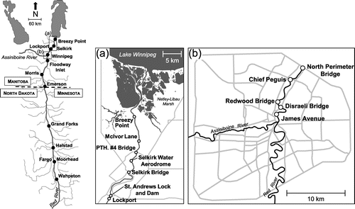
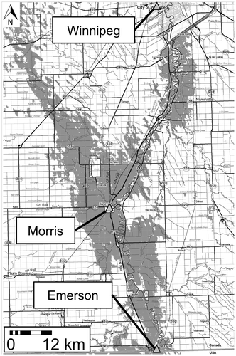
The geographical and hydrological setting of the Red River has been described elsewhere in this special issue (Rannie Citation2015), and a background to flood control measures in Manitoba is described by Blais et al. (this issue). Figure shows points of interest and major hydrometric gauge locations along the Red River that are referenced throughout this paper.
Figure 1. Points of interest and major hydrometric gauges along the Red River. (a) The region downstream of the City of Winnipeg; (b) the area within the city.
Causes of the flood
The major causes of the 2009 spring flood on the Red River were the unfavourable antecedent conditions in the river basin during the spring freshet and the unusual ice processes that further complicated local flooding and flood mitigation strategies. Flood forecasters were aware of the potential for spring flooding early in 2009, based on several factors including soil moisture and snowpack conditions.
Precipitation in the autumn of 2008, particularly a heavy rainfall event in November 2008 over southeastern Manitoba and adjacent portions of the US, resulted in record high soil moisture levels before freeze-up. Airborne soil moisture surveys showed soil moisture within the root zone was average to above average in most agricultural areas of Manitoba, and well above average over the Red River Valley (Manitoba Water Stewardship Citation2009a). Furthermore, temperatures from December to January were well below average, resulting in deep soil frost penetration. These conditions suggested that wet, frozen soils were prevalent in the Red River Basin, indicating a high potential for spring flooding.
Early analysis of snow cover in the watershed due to winter precipitation events indicated that the snowpack in Manitoba was close to average, while snowpack in the US was above average. The period of September 2008 through March 2009 was the wettest recorded in history for North Dakota (Macek-Rowland and Gross Citation2011). Airborne gamma surveys conducted by the National Operational Hydrologic Remote Sensing Center (NOHRSC) in early March showed that large areas of North Dakota and northern Minnesota were characterized by snow water equivalents (SWE) of 75 to 125 mm, with areas approaching 250 mm (US Department of Commerce Citation2009). The water content in the Manitoba portion ranged between 50 and 75 mm (AECOM Citation2010), corresponding to SWE anomalies ranging from 110 to 200% of normal (Canadian Cryospheric Information Network Citation2014). A heavy snowfall event which occurred on 10 March in the US portion of the Red River Basin further increased the potential for serious spring flooding.
Prior to spring melting, forecasters across the Red River Basin were aware of the high potential for flooding. In their outlook on 20 March, the Hydrologic Forecast Centre in Manitoba predicted that the crest at James Avenue would range from 227.4 to 228.6 m (moderate flood stage is 227.25 m), depending on weather conditions and the necessary operation of major flood control works (AECOM Citation2010). In North Dakota, the outlook issued on 13 March indicated a 100% chance of major flooding in Fargo (stage greater than 271.82 m) and a 33% chance of exceeding the flood level of 1997 (274.78 m). It was also estimated that there was a 25% chance of exceeding Fargo’s all-time flood record of 274.90 m, which occurred in 1897 (US Department of Commerce Citation2009).
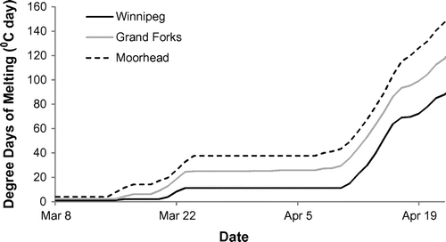
Although antecedent conditions can exacerbate the size and duration of a flood, the severity of the 2009 flood was heavily influenced by the timing and nature of the melt period which occurred in two separate events. In Winnipeg, an early melt occurred from 20 to 23 March March and was followed by a 2-week period of temperatures below 0°C; the average daily mean temperature from 25 March to 7 April was –5.6°C (Environment Canada Citation2014a). A second melt occurred from 10 to 13 April, when temperatures once again rose above 0°C. As was the case in the flood of 1997, the south-to-north gradient in thawing conditions had implications on flooding in 2009. As shown in Figure , both Moorhead and Grand Forks accumulated more degree days of melting than Winnipeg during the early melt period, thereby causing more significant melting in the US portion of the basin.
Figure 2. Cumulative degree days of melting at locations along the Red River from Moorhead, Minnesota, to Winnipeg, Manitoba. Data obtained from Environment Canada (Citation2014a) and National Oceanic and Atmospheric Administration (Citation2014).
In Fargo, snow began to melt rapidly on 16 March. The snow depth at this time was 700 mm, and SWE was 130 mm. Warm temperatures on 22 March (high exceeding 10°C) increased the melt rate from 5 mm/h to over 20 mm/h. By the end of 22 March, all snow was melted (Kim et al. Citation2011). Snowmelt from the US portion of the basin produced high river levels under strong, stationary ice still intact in Manitoba in early April. The 2-week cold spell between melt events in Manitoba prevented thermal weakening of river ice, resulting in record high water levels with ice still in place. The cold spell also temporarily halted the melt in Manitoba. The timing of the second melt resulted in runoff from Manitoba tributaries that was concurrent with high flows coming from the United States.
Flood magnitude
The 2009 spring flood ranks among the highest in much of Manitoba and North Dakota. A summary of gathered hydrometric data in the US portion of the watershed in 2009 was prepared by the United States Geological Survey (USGS) (Macek-Rowland and Gross Citation2011). Hydrometric data for Canadian gauges were obtained from Environment Canada (Citation2014b) (see Figure for gauge locations).
Flood crest elevations offer a convenient measure to indicate the magnitude of flooding, as they can be directly related to land inundation. As shown in Table , most locations experienced water levels that approached or exceeded their respective peak of record. Recurrence intervals calculated by USGS define the 2009 flood as a 10–50-year event in Grand Forks, a 50-year event in Wahpeton and a 50–100-year event in Fargo and Halstad.
Table 1. Comparison of 2009 peak stages to historical records along the Red River.
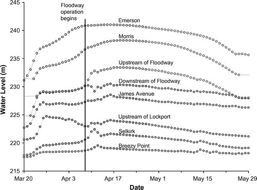
Time series of water level measurements of gauges between Emerson and Breezy Point are compared in Figure . Note the effect of Floodway operation on upstream and downstream water levels, and the localized peaks near Selkirk and Breezy Point caused by ice jamming.
Figure 3. Daily average water level measurements from Emerson to Breezy Point. Hollow and filled circles indicate gauges located upstream and downstream of the Red River Floodway inlet, respectively. Data obtained from Environment Canada (Citation2014b).
Within Winnipeg, the observed crest at James Avenue was 3.06 m lower than it would have been under natural conditions (i.e. without the operation of the major flood control projects in the province: the Red River Floodway, Assiniboine Diversion and Shellmouth Dam; (Manitoba Water Stewardship Citation2009a). The total volume of water diverted around Winnipeg via the Red River Floodway in 2009 was 3.3 billion m3 (Manitoba Water Stewardship Citation2009b), the second highest on record (1997 saw 4.1 billion m3 diverted). The peak flow of the Floodway was 1235 m3/s, much less than the 1997 peak of 1890 m3/s. Without the operation of major flood infrastructure, the peak flow at James Avenue would have been 3612 m3/s, similar to that experienced in 1861 (Blais et al. this issue). Based on a flood frequency analysis using a Log-Pearson type III distribution of natural James Avenue flows since 1940, the 2009 natural peak flow has a return period of approximately 31 years. Downstream of Winnipeg, the unregulated flow volume of 14.7 billion m3 at Selkirk was the highest on record since 1852, surpassing the flood volume of 13.2 billion m3 of the 1997 flood.
Flood extent progression and flood-fighting measures
The progression of the 2009 spring flood can be divided into three regions based on the driving forces behind flood extents in each: upstream of Winnipeg (including southern Manitoba and the US), within the City of Winnipeg and downstream of Winnipeg to Breezy Point.
Upstream of Winnipeg
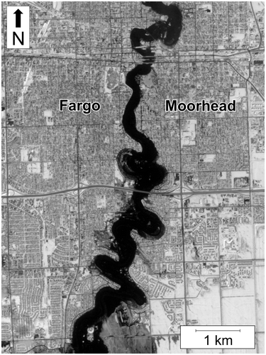
Flooding upstream of Winnipeg was governed by the rate of melt in the southern portion of the basin, which affected the timing and volume of water moving downstream. Flooding occurred first in the US portion of the watershed. Due to early outlooks indicating a high potential for spring flooding, Governor John Hoeven declared a statewide emergency flood disaster in North Dakota on 13 March. Community leaders were advised to prepare for record flood levels, and 500 National Guard troops were deployed (Cass County Sheriff’s Office Citation2009). The urgency of flood preparations was increased when the first deterministic river forecast for Fargo on 19 March indicated that the crest would range from 273.98 to 274.88 m, and could occur as early as 28 March (2 weeks earlier than the previous outlook predicted; (US Department of Commerce Citation2009). In Fargo, the Red River reached flood stage of 268.18 m on 21 March, and rose rapidly 1 week later to 275.13 m on 28 March. On 24 March, President Barack Obama declared a major disaster in North Dakota when the crest of the river exceeded 171% of flood stage based on the local datum (Kim et al. Citation2011). The peak extent of flooding was captured by the Advanced Land Imager on the National Aeronautics and Space Administration (NASA)’s EO-1 satellite (Figure ). As the first crest receded, substantial runoff continued to enter the river from upstream tributaries now experiencing rainfall. A second crest of 273.04 m occurred on 16 April. Water levels in the Fargo–Moorhead area remained above flood stage for nearly 2 months (Macek-Rowland and Gross Citation2011).
Figure 4. Peak flood land inundation near Fargo, North Dakota, and Moorhead, Minnesota, on 28 March 2009. Imagery was captured by the Advanced Land Imager on the National Aeronautics and Space Administration (NASA)’s EO-1 satellite (NASA Citation2009).
The emergency management system was initiated when the flood stage rose to 271.78 m. This included road closures, and diking and sandbagging along flood-vulnerable zones. It was estimated by the City of Fargo that 2 million sandbags were required to guard against the rising stage of the Red River. Volunteers produced up to 400,000 sandbags per day, which were deployed to build 15–20 km of sandbag dikes along existing levees. An earth dike was built near downtown and other critical locations to increase flood protection to approximately 275.78 m, and a 5–10 km earth dike was added to the existing levees near vulnerable zones along the boundary of the city. The rapid response and action of the City of Fargo helped mitigate significant flooding in the area and minimize property damage. However, despite these efforts, hundreds of homes were ruined and mandatory evacuations in certain areas of the city were necessary (Kim et al. Citation2011). A number of infrastructure upgrades were made in Fargo following the 2009 flood, including the installation of new waterways and additional culverts to increase the discharge capacity.
The Red River crested at Grand Forks on 1 April, reaching a level of 252.48 m (AECOM Citation2010). The extent of flooding was less severe in the Grand Forks area due to the flood control measures implemented following the flood of 1997, which had disastrous impacts on the city.
Flooding in southern Manitoba lasted from approximately 8 April to 15 May, with maximum extents of land inundation occurring around 20 April. Peak land inundation was captured using RADARSAT imagery (Figure ). The first area to flood was “Lake Roseau,” as water spilled over the banks of the Roseau and Marsh Rivers around 8 April. As water levels continued to rise, backwater effects caused severe flooding near the town of Morris. Rising air temperatures then melted the snowpack, leading to localized flooding that was governed by local drainage conditions. As these waters drained toward the Red River, the flooded area reached its maximum extent on 20 April. During this time, approximately 1000 km2 of agricultural land was inundated between Emerson and the Floodway inlet, compared to 1840 km2 for the 1997 flood (Manitoba Water Stewardship Citation2009a). Overland flooding was reduced by steaming of culverts and small bridges to remove ice blockages. Flood waters finally began to recede in early May.
Figure 5. Land inundation in southern Manitoba based on RADARSAT imagery on 20 April 2009 (adapted from Canadian Space Agency Citation2009).
Because of flood-proofing strategies implemented following the flood of 1997, communities in the basin south of Winnipeg were adequately prepared to deal with the anticipated flood levels. Over the duration of the flood, many emergency precautions and flood-fighting measures were conducted. Provincial Trunk Highway #75 at Morris was closed for 37 days, from 7 April to 13 May. Fifteen community ring dikes were activated in the Red River Valley to protect towns; however, many homes in the valley were accessible only by boat for more than a month. The province also purchased 25.1 km of Tiger Dam flood tubes and 7.6 km of Aquadams and deployed them in the field during the flood (Manitoba Water Stewardship Citation2009a).
Floodway operation
On 24 March, the water level on the Red River exceeded the level of the berm at the entrance to the Red River Floodway, and water began to flow into the Floodway without operation of the Inlet Control Structure. By 7 April, this unregulated flow in the Floodway reached approximately 142 m3/s. Operation of the Inlet Control Structure is avoided when there is a stationary ice cover within Winnipeg and there is a possibility of ice entering the Floodway. On 8 April 2009, both of these conditions were present; however, high water levels within Winnipeg (increased in part due to a downstream ice jam at Lockport) prompted a limited operation of the Floodway Inlet Control Structure, forcing additional water to spill into the Floodway.
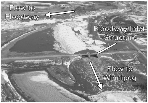
Once the Inlet Control Structure was in operation, a large ice sheet remained intact just upstream (Figure ). This ice sheet fortuitously prevented ice from entering Winnipeg and exacerbating ice jams within the city; however, it also caused ice traveling from upstream on the Red River to be diverted into the Floodway. The large volume of ice entering the Floodway was unprecedented, and large ice sheets jammed at St. Mary’s Bridge over the Floodway. The province responded by deploying 15 long-reach excavators on either side of the Floodway just upstream of the bridge to remove ice as quickly as possible. Bulldozers removed the ice debris piles, which allowed the excavators to work continuously. Fortunately, by 10 April, the ice jam had cleared from the Floodway and only ice rubble continued to flow.
Figure 6. Floodway Inlet Control Structure (centre of image) with upstream ice cover on 9 April 2009, at 5 pm. View is looking south. Water flows over the inlet structure and through Winnipeg (bottom of image), or is diverted east around the city (left side of image). Photo courtesy of G. Mohr.
Within Winnipeg
The presence of a competent ice cover (thickness ~0.6 m) within Winnipeg through the first 2 weeks of the flood presented city flood fighters with the challenge of predicting the potential likelihood and consequence of ice jams. Historically, the ice cover within Winnipeg had always cleared by the time the water level at the James Avenue gauge reached 227.4 m, but this did not occur in 2009. Early on, city officials used the Winnipeg Flood Manual (described in Blais et al. this issue) to compute ice-affected water surface profiles within the city. A decision was made to increase the freeboard on secondary dikes in areas of high vulnerability from 0.6 m to 1.2 m.
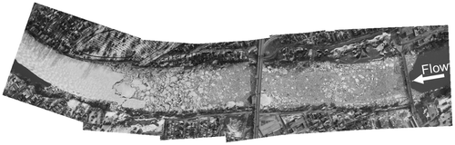
Figure illustrates water level variation on the Red River at several gauges within the city using data from the City of Winnipeg and Water Survey of Canada (WSC) (see Figure for measurement locations). The effects of an ice jam near the Disraeli Bridge in the early hours of 11 April (Figure ) are seen in the increase in water level upstream (James Avenue gauge) and a corresponding decrease in downstream water level (Redwood Bridge gauge) due to the temporary reduction in discharge as upstream flow remained in storage. As the jam cleared in the afternoon and moved downstream of the Redwood Bridge, a similar pattern of increasing upstream and decreasing downstream water levels was observed. Water level variations in excess of 0.6 m occurred over a few hours, highlighting the need for flood protection measures to be in place to a sufficient level and well in advance.
Figure 7. Water levels within the City of Winnipeg from 10–14 April 2009. Data from the City of Winnipeg and Water Survey of Canada.
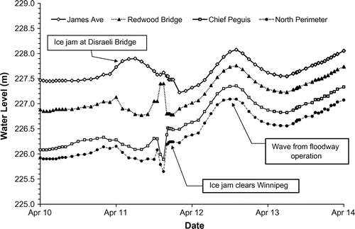
Figure 8. Ice jam on the Red River at Disraeli Bridge (center of image) on 11 April 2009 at 8:30 am. Flow from right to left. Photos by Taiga Air Services Ltd, courtesy of the Province of Manitoba.
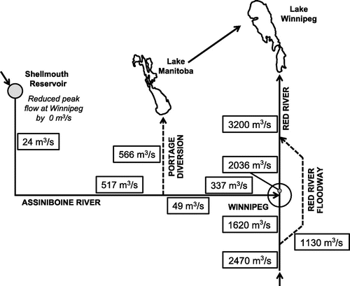
Water levels at James Avenue crested on 16 April when an ice run on the Assiniboine River coincided with crests on local tributaries, and high flows at the Floodway inlet caused the flow through the city to rise to approximately 2036 m3/s at James Avenue. Figure shows a “snapshot” schematic of the flows at various locations in the river network at the time of the peak at James Avenue. The flow diverted around Winnipeg at the time of the peak was 1130 m3/s, which is less than 30% of the Floodway channel’s expanded capacity of 3964 m3/s. Even with Floodway operation, flood mitigation efforts had to be taken within the city. Current information was made available to the public by daily media briefings and through the internet. Provincial forecasters provided the city with 5-day forecasts and crest forecasts with and without effects of ice jams, to aid with planning and emergency operations. These forecasts prompted the city to raise the freeboard of its most vulnerable dikes, which saved hundreds of homes from being flooded. Approximately 650,000 sandbags were used to protect 270 properties within Winnipeg over the course of the flood (G. Mohr, pers. comm., 2014). Despite these efforts, four buildings in Winnipeg were partially flooded (Manitoba Water Stewardship Citation2009a).
Figure 9. Manitoba flows at the time of flood crest at James Avenue (16 April 2009). Hydrometric data obtained from Environment Canada (Citation2014b).
Downstream of Winnipeg
Areas along the Red River downstream of Winnipeg also faced significant challenges due to ice jams in 2009. Since this was an area known to be susceptible to ice jams, the most significant ice jam in the area having occurred in 2007, the province had initiated an ice jam program several years prior. Starting in early March 2009, the ice cover from Netley–Libau Marsh to Selkirk was weakened using several pieces of specialized cutting equipment, and the ice cover along the middle of the channel was broken up using two amphibious excavators. These Amphibex units were used at several locations in 2009, including at an ice jam on the Red River near the South Perimeter Bridge, and they continue to be an integral part of the province’s ice jam mitigation program. In 2009, ice cutting was also used on the Icelandic River at Riverton, on the Whitemud River at Westbourne and on the Assiniboine Diversion (Manitoba Water Stewardship Citation2009a).
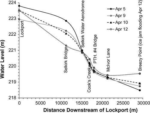
An ice jam formed near St. Andrews Lock and Dam at Lockport in late March and moved downstream into the City of Selkirk several days later. Figure shows the water level variation within and around Selkirk in April 2009. The ice jam effects are clearly visible in the region between Selkirk Bridge and Provincial Trunk Highway (PTH) #4, where the water surface profile on 5 April was several times steeper than during open water conditions. Peak levels occurred in Selkirk on 11 April, and the ice jam moved downstream and reformed once more near Breezy Point on 12 April, flooding properties in the area. The daily water level data taken at this particular gauge location do not adequately reflect the rapid water level variations that occurred due to its low temporal frequency. Eyewitness accounts estimate a 2.8-m total rise, 1.22 m of which occurred over a duration of 4 hours. Such dramatic rises in water level presented serious safety concerns to both residents who remained in their houses and emergency personnel, prompting a CAD $4.4-million buyout program for flood-prone properties near Breezy Point, St. Andrews and St. Clement.
Figure 10. Water levels near Selkirk during April 2009 ice jamming.
Flood damages and savings
Flooding within the City of Winnipeg was largely avoided due to the operation of major infrastructure and emergency procedures taken as forecasted levels changed. It is estimated that the operation of the Red River Floodway, Assiniboine Diversion and Shellmouth Dam prevented on the order of CAD $10 billion in flood damages (Manitoba Water Stewardship Citation2009a). Progressive closures of ring dikes in the Red River Valley minimized disruption while ensuring that communities were protected as the river stage increased. It is estimated that the ring dikes saved approximately CAD $700 million in flood damages in 2009. Another CAD $100 million of potential damages were avoided due to the infrastructure implemented after the flood of 1997, which protected 1730 individual homes and businesses from flooding in 2009 (Manitoba Water Stewardship Citation2009a).
Conclusions
The 2009 Red River flood was the result of high antecedent soil moisture in the basin, high winter snowpack, unusual melt conditions and significant ice jamming events. Flood forecasters recognized the potential for severe flooding early in 2009, allowing flood preparations to begin well in advance of the event. However, the ice jamming events were much less predictable, introducing uncertainty in the forecasted crests. The City of Winnipeg took severe ice jamming into account in their preparations by increasing the freeboard on their diking system in vulnerable areas, which prevented the flooding of hundreds of homes. Ice processes also complicated the operation of the Red River Floodway. In 2009, the Inlet Control Structure was operated while ice still remained within the city and upstream of the gates. This had never been done before, and extensive measures had to be taken to reduce the risk of ice jamming within the Floodway channel. Nevertheless, the Floodway and other major flood mitigation projects (Assiniboine Diversion and Shellmouth Dam) were successful in reducing the crest at James Avenue to 228.62 m, compared to the natural crest of 231.68 m that would have occurred without these structures. The avoidance of significant flooding in Winnipeg demonstrated the effectiveness of the flood prevention infrastructure in place, as well as the usefulness of the Flood Manual as a valuable tool for flood fighting within the city. Furthermore, experiences with the unusual ice processes seen in 2009 will serve to enhance the knowledge of flood forecasters and allow them to better predict the effects of such events in the future.
The CAD $4.4-million buyout program for flood-prone properties downstream of Selkirk will ensure that future flood damages in these areas are minimized and that emergency response work is simplified, thereby further improving Manitoba’s flood resiliency. The Province of Manitoba continues to conduct a river ice monitoring program that employs ground, aerial and remote sensing technologies to prepare for the potential impacts of river ice on future spring flooding.
Acknowledgements
The authors wish to thank Eric Blais, John Harris and Grant Mohr for the data they provided and for sharing their experiences with the 2009 Red River flood.
References
- AECOM. 2010. Analysis of the 2009 Red River Valley flood. Winnipeg, MB: Prepared for Manitoba Infrastructure and Transportation (MIT), 47 pp.
- Blais, E., S. Clark, K. Dow, W. Rannie, T. Stadnyk, and L. Wazney. 2015. Background to flood control measures in the Red and Assiniboine river basins. Canadian Water Resources Journal. doi:10.1080/07011784.2015.1036123
- Canadian Cryospheric Information Network. 2014. Snow water equivalent. https://www.ccin.ca/home/ccw/snow/current/swe ( accessed December, 2014).
- Canadian Space Agency. 2009. http://www.asc-csa.gc.ca/.
- Cass County Sheriff’s Office. 2009. Eastern North Dakota 2009 spring flood after action report. Cass County, ND: Cass County Government, 94 pp. https://www.casscountynd.gov/county/depts/sheriff/Documents/Flood%20After%20Action%20Report.pdf ( accessed December, 2014)
- Environment Canada. 2014a. Climate. http://climate.weather.gc.ca/ ( accessed May, 2014).
- Environment Canada. 2014b. Wateroffice: Historical hydrometric data search. http://wateroffice.ec.gc.ca/search/search_e.html?sType=h2oArc ( accessed May, 2014).
- Kim, Y. J., X. Chu, and S. Gajan. 2011. Flood of the Red River Basin in 2009 and effectiveness of rapid mitigation efforts. Natural Hazards Review 12(1): 1–5. http://ascelibrary.org/doi/abs/10.1061/%28ASCE%29NH.1527-6996.0000030 ( accessed May, 2014).
- Macek-Rowland, K. M., and T. Gross. 2011. 2009 Spring floods in North Dakota, western Minnesota, and northeastern South Dakota. United States Geological Survey Scientific Investigations Report 2010-5225. Reston, VA, 53 pp. http://pubs.usgs.gov/sir/2010/5225/pdf/sir2010-5225.pdf (accessed May, 2014).
- Manitoba Water Stewardship. 2009a. Manitoba 2009 spring flood report. Winnipeg, MB: Government of Manitoba, 34 pp. http://www.gov.mb.ca/waterstewardship/reports/floods/spring_flood_2009.pdf ( accessed May, 2014).
- Manitoba Water Stewardship. 2009b. Red River Floodway operation report: Spring 2009. Winnipeg, MB: Government of Manitoba, 22 pp. http://www.gov.mb.ca/waterstewardship/reports/floodway/red_river_floodway_operation_report_2009.pdf ( accessed May, 2014).
- National Aeronautics and Space Administration (NASA). 2009. Flooding on the Red River. http://earthobservatory.nasa.gov/NaturalHazards/view.php?id=37702 ( accessed May, 2014).
- National Oceanic and Atmospheric Administration (NASA). 2014. National Climatic Data Centre. Climate data online search. http://www.ncdc.noaa.gov/cdo-web/search ( accessed May, 2014).
- Rannie, W. 2015. The 1997 flood event in the Red River basin: Causes, assessment and damages. Canadian Water Resources Journal. doi:10.1080/07011784.2015.1004198
- US Department of Commerce. 2009. NWS central region service assessment: Flood event in the Dakotas and Minnesota, principally the Red River of the North, March–April, 2009. 44 pp. http://www.crh.noaa.gov/crh/pdf/RRN2009_RegionalReview_Final.pdf ( accessed May, 2014).