
Abstract
In April–May 2008, New Brunswick (NB) experienced its worst spring flooding in 35 years along the entire length of the Saint John River and several of its tributaries. Snow water equivalent (SWE) in the snowpack had remained high during the winter and early spring. Warm temperatures and rainfall caused some of the snowpack to melt, which resulted in an increase in river water levels above flood stage in several communities. A major storm on 28 and 29 April 2008 produced heavy rainfall in the upper basin, and this rain-on-snow event resulted in severe flooding at several communities along the river. The flood affected some 1600 properties, causing in excess of CAD $23 million in damages (2008 dollars), but no deaths or serious injuries resulted.
En avril–mai 2008, le Nouveau-Brunswick (NB) a connu sa pire inondation du printemps en 35 ans sur toute la longueur de la rivière Saint-Jean et dans plusieurs de ses affluents. L’équivalent eau-neige (EEN) dans le manteau neigeux était demeuré élevé pendant l’hiver et au début du printemps. Les températures élevées et les précipitations ont fait fondre une partie de la neige accumulée, ce qui a entraîné une hausse des niveaux d’eau au-dessus du niveau d’inondation dans plusieurs collectivités. Une tempête majeure survenue les 28 et 29 avril 2008 a occasionné des pluies abondantes dans la partie supérieure du bassin, et cet événement pluie-neige s’est traduit par de graves inondations dans plusieurs collectivités le long de la rivière. L’inondation a causé préjudice à quelque 1 600 propriétés et a entraîné des dommages de plus de CAD 23 millions de dollars (de 2008), bien qu’on ne déplore aucun décès ni aucune blessure grave.
Geographic setting
The Saint John River Basin
The Saint John River Basin is both an international (Canada–USA) and interprovincial (Quebec–New Brunswick) river basin. It has a drainage basin area of approximately 55,200 km2, of which slightly more than half is located in New Brunswick (Figure ).
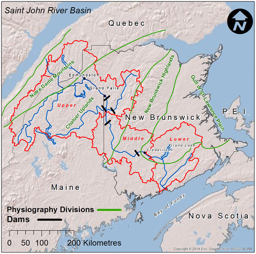
Figure 1. Physiographic features of the Saint John River Basin.
Over a half million people live in the Saint John River basin, mainly along the Saint John River and its major tributaries, which during colonial times were navigable transportation routes. Most of the basin is forested, but agricultural areas exist along the Saint John River from Grand Falls to Woodstock (the potato belt), from Fredericton to Gagetown, and along the Kennebecasis River and its tributaries in the Sussex area.
Most of the prominent physiographic features of the Saint John River basin are aligned in a southwest to northeast direction (Figure ). The headwater area of the basin, situated in the extreme northwest, lies within a small portion of the Notre Dame Mountains. Much of the Saint John River Basin upstream of Woodstock, however, is in the Chaleur Uplands, a peneplain ranging in elevation from 240 to 300 m. The New Brunswick Highlands extend from Chaleur Bay southwest and then along the coast of the Bay of Fundy. Portions of the basin from Woodstock to Fredericton, and from Oak Point to Saint John, lie in the New Brunswick Highlands. The New Brunswick Highland exhibits more rugged topography than the Chaleur Uplands, as metamorphosed sedimentary rocks intruded by igneous rock are more resistive to erosion than the primarily sedimentary rock of the Chaleur Uplands (Inland Waters Directorate Citation1974).
The New Brunswick Lowlands, a triangular region with its base along the Northumberland Strait, lies between the two arms of the New Brunswick Highlands. The area is flat to gently undulating (mostly below 150 m elevation) and has relatively stone-free glacial soils underlain by sedimentary rocks (Inland Waters Directorate Citation1974). The major flood plain from Fredericton to Lower Jemseg lies in the New Brunswick Lowlands (see Figure ).
Hydropower developments were established along the Saint John River at Grand Falls in 1927, Beechwood in 1955 and Mactaquac in 1968, and there are hydropower developments on the lower reaches of the tributary Aroostook and Tobique Rivers that flow into the Saint John River upstream of the Village of Perth–Andover. There are small hydropower and storage dams elsewhere in the basin, including the sub-basins of the Madawaska, Green and Tobique Rivers.
The northern half of the basin has cold winters and warm summers distinctive of a continental climate, whereas in the southern portion of the basin, continental and maritime influences occurs, with the temperature-moderating effect of the ocean increasing closer to the coast. April climate normals (1981–2010) for several stations within the basin are provided in Table . (Many floods occur during the month of April.) Normal April daily average temperatures range from about 3°C in the north to 5°C in the south. Normal April precipitation amounts range from 50 mm in the north to 105 mm in the south, with most of the precipitation falling as rain.
Table 1. April climate normals 1981–2010 for selected stations within the Saint John River Basin.
The Saint John River
The Saint John River flows approximately 673 km, falling approximately 480 m from its headwaters upstream of Little John Lake in Maine, USA, to where it empties into the Bay of Fundy at Saint John (Inland Waters Directorate Citation1974). Major tributaries are listed in Table .
Table 2. Major tributaries of the Saint John River.
Near Allagash, Maine, the Saint John is joined by one of its major tributaries, the northerly flowing Allagash River. The Saint John River then flows northeasterly from Maine into New Brunswick, and forms part of the international boundary between Maine and New Brunswick. The river flows pass the communities of St.-Francois-de-Madawaska, Clair and St. Hilaire. At Edmundston (NB), the river turns southeast, passing between St. Leonard and Grand Falls. Near Grand Falls, the river no longer forms the international boundary, and downstream remains in New Brunswick for the remainder of its length.
The middle stretch of the Saint John River from Grand Falls to Mactaquac flows through the New Brunswick Highlands. Communities along this stretch of the river include Perth–Andover, Florenceville, Hartland and Woodstock.
Downstream of the Mactaquac dam, which is a short distance upstream of the head of tide, the Saint John River flows eastward past the provincial capital of Fredericton before turning southward at Oromocto. This part of the river valley lies in the New Brunswick Lowlands, and the river is broad and shallow, and contains low islands. The major flood plain area of Fredericton to Lower Jemseg lies in this physiographic region. Nearer the coast, the Saint John River is surrounded by the low hills of the St. Croix Highlands (part of the New Brunswick Highlands) before discharging into the Bay of Fundy at the industrial city of Saint John.
Flooding characteristics of the Saint John River downstream of the Mactaquac dam are complicated by the floodwater storage in large bodies of water along and adjacent to the river, and by the tidal regime in the Bay of Fundy. The short Jemseg River connects the Saint John River to the Grand Lake system (Grand Lake is New Brunswick’s largest lake). During flood periods, water continually flows in a reverse direction through the Jemseg River into Grand Lake. The Grand Lake system provides floodwater storage, and thus influences flood levels along the lower Saint John River. Other off-channel storage includes the Oromocto River valley, Washademoak Lake, Belleisle Bay and Kennebecasis Bay. At Saint John, a narrow gorge at the river mouth restricts outflow to the Bay of Fundy causing water upstream to back up during high tides.
Water levels reached during a particular flood are a function of runoff volume as well as antecedent water levels of the main channel and of the large bodies of water adjacent to the river. Therefore, a given volume of basin runoff from the Basin may produce varying water levels. The unique physical and hydraulic characteristics of this lower reach of the Saint John River are described in detail in the publication New Brunswick Flood, April–May 1973 (Inland Waters Directorate Citation1974).
Causes of the flood
In the Saint John River Basin, the amount of spring runoff is highly dependent upon the amount of water accumulated in the snowpack prior to the freshet. The snow surveys in New Brunswick during the first week of February, March and April, summarized in Table , reveal a higher-than-normal snow water equivalent (SWE). Based on past events with similar snow pack, officials expected flooding throughout the lower half of the basin, even without significant rainfall, and this message was communicated to the media and the public well in advance (MacGillvray Citation2008).
Table 3. Summary of 2008 snow water equivalents, Saint John River Basin.
Table provides a summary of April 2008 climate data for selected stations in the Saint John River Basin. During April, mean daily temperatures for the month exceeded 3°C, and the total April degree-days exceeded 300 degree-days (°C) throughout the New Brunswick portion of the basin. Snowmelt caused by warmer-than-normal temperatures and rainfall led to increasing flows and water levels during April.
Table 4. Summary of April 2008 climate data for selected stations, New Brunswick portion of Saint John River Basin.
Flooding in most parts of the Saint John River basin, however, became severe after a late-April storm provided rainfall in northern portions of the basin. On Monday 28 April 2008, a large area of high pressure across the Canadian Maritimes drifted eastward as an area of low pressure developed over Pennsylvania (Sturey et al. Citation2008). Rain developed across southern Maine on Monday 28 April, and moved into northern sections of the state that night. On Tuesday 29 April, the low-pressure system moved steadily northeastward, reaching Maine during the morning hours and crossing northern Maine later that day (Sturey et al. Citation2008). Rain continued to be heavy at times during the day as the southeast flow continued to transport moisture-laden air (Sturey et al. Citation2008). Rainfall amounts in Aroostook County, Maine, were in the range of 35 to 90 mm. The system exited the region Wednesday 30 April.
In New Brunswick, rainfall amounts were generally lower, with most of the rainfall falling on Tuesday 29 April (Table ). Rainfall amounts were greater in the northern part of the Province, with much less rainfall in the southern portion of the Saint John River Basin.
Table 5. Rainfall amounts (mm), 27–30 April 2008, at selected climate stations, Saint John River Basin.
Flood chronology
Upper basin
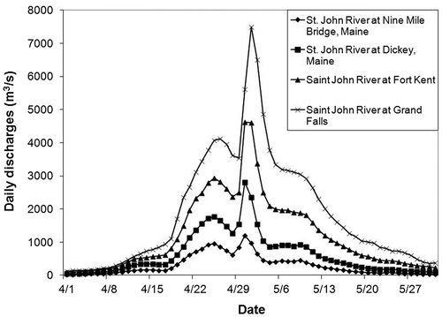
Hydrographs of discharges recorded at four hydrometric stations along the main stem of the Saint John River are shown in Figure . Discharges started to increase about mid-April, peaked 25 April (26 April at Grand Falls) and started to decline before the storm of 29 and 30 April. Maximum daily flows of approximately 1200 m3/s, 2800 m3/s and 4630 m3/s occurred on 30 April at Nine Mile Bridge, Dickey and Fort Kent, respectively. (For comparison, the mean annual flow and mean April flow for the Saint John River at Fort Kent are approximately 279 m3/s and 744 m3/s, respectively). The maximum daily discharge of 7500 m3/s at Grand Falls occurred on 1 May.
Figure 2. Daily discharges recorded at four hydrometric stations along the main stem of the upper Saint John River, April–May 2008.
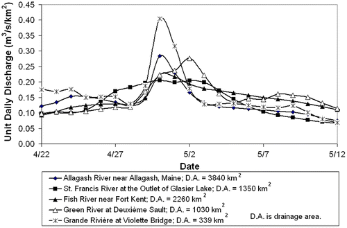
Daily unit discharges in five tributaries to the upper Saint John River for the period 22 April–12 May are shown in Figure . As for the main stem of the Saint John River, the discharges peaked around 26 April from a warmer-than-normal April, until a significant rain event occurred on 28–29 April with highest amounts in northern Maine. Maximum unit daily discharges ranged from 0.20 m3/s/km2 to 0.28 m3/s/km2 for the four larger tributaries.
Figure 3. Unit daily discharges recorded at four hydrometric stations on tributaries to upper Saint John River, 22 April–12 May 2008.
The combination of snowmelt from record snowfall during the 2007–2008 winter seasons and between 35 and 75 mm of rain in northern Maine resulted in major flooding on the Saint John and Fish Rivers from 30 April through 1 May 2008. This flooding resulted in the closure of several roads.
Figure depicts a flood profile of the 2008 flood event along the Saint John River from Saint-François-de-Madawaska to Grand Falls (R.V. Anderson Associates Limited [RVA] Citation2009). The flood profile was obtained from the orthophoto images taken during the flood event. The profile may not represent peak water levels or a simultaneous measurement of flood levels as water levels along the river may have been changing slightly during the acquisition of the orthophotos. Flood markers found in the Clair Historic Village and physical evidence at other locations were surveyed, and these flood levels are also depicted in Figure .
Figure 4. Flood profile for 2008 along the Saint John River upstream of Grand Falls (RVA Citation2009).
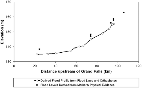
At St. François-de-Madawaska, several residences were surrounded by water. Further downstream at Clair, the historical village (approximately 95.5 km upstream of Grand Falls) sustained flood damages as water depths were in excess of 1.5 m above ground elevation (approx. 1.68 m at the historical church and 1.29 m at the main historical residence). Several streets in Fort Kent, Maine, were inundated as the water levels rose in the Fish River, which peaked at 4.25 m. Approximately 600 people were evacuated as 140 residences became flooded. The international bridge across the Saint John River connecting Fort Kent, Maine, and Clair, New Brunswick, was closed as waters rose to the lower girders. The levee along the Saint John River that protects Fort Kent was nearly overtopped. The road between Clair and Edmundston was inundated at Caron Brook (approximately 93.4 km upstream of Grand Falls) and Baker Brook. Over 2 m of water were estimated to have entered cottages in the St. Hilaire area (approximately 73.9 km upstream of Grand Falls).
Flood waters inundated parts of Edmundston and Madawaska, which is across the river in Maine. Flooding occurred along the Saint John River and its two tributaries, the Madawaska River and the Iroquois River, which flow into the Saint John River at Edmundston. Flooding was experienced in many parts of the city, including downtown Edmundston and the main street of St. Basile area, but the hardest hit was the Saint-Jacques area along the Madawaska River. Mobile homes and vacation homes in one campground were still under water a week after the flood crest (Wishart Citation2008).
Downstream of Edmundston, serious flooding occurred in Saint Leonard and Ste.-Anne-de-Madawaska. Flood damages occurred to many riverfront properties in Saint Leonard, and numerous homes and businesses in Ste. Anne-de-Madawaska were surrounded by water on 1 May.
Middle basin
The rampant Saint John River engulfed the NB Power turbines and generation equipment at the base of the Grand Falls gorge (Wishart Citation2008). NB power workers were evacuated as the water rose quickly. Some residences in the area were also affected. The flood crest occurred on 30 April. Downstream at Beechwood Dam, all the gates were opened to pass the floodwaters, but hydropower production was temporarily shut down during the flood (Wishart Citation2008).
Probably hardest hit along the stretch of the river from Beechwood to Woodstock was Bristol, where the main street was inundated and several buildings flooded. However, several buildings were surrounded by floodwaters elsewhere along the river, including farmhouses and barns in the Florenceville area. At Hartland, the world’s longest covered bridge, a major tourist attraction, was threatened as the water rose close to the bottom chords of the superstructure (Wishart Citation2008).
Lower basin
Stages measured at water level stations along the lower Saint John River, April–May 2008, are depicted in Figure . Water levels along the lower Saint John River increased throughout April. Gradually, flood stages were exceeded in several communities, but flow from the upper and middle portions of the basins due to the late-April storm aggravated flooding.
Figure 5. Stages along the lower Saint John River, April–May 2008.
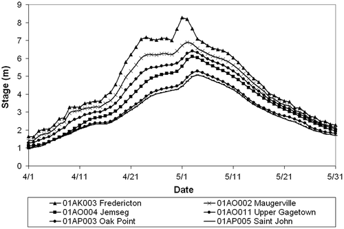
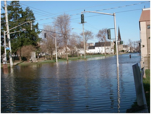
Water levels in Fredericton exceeded flood stage by 22 April and stayed above flood stage for approximately 17 days (until 8 May), peaking at 8.36 m on 1 May. Initially, only low-lying sports fields and some riverfront properties were affected. On 25 April, water levels in New Brunswick's capital were thought to be stabilizing, but a few days later it rained heavily in upper portions of the basin. By late Wednesday evening, 30 April, 34 streets in Fredericton had been closed. By the following morning, the flood had inundated a large area of Fredericton (Figure ). More than 50 streets within the city had been closed due to high waters, including off ramps on the city’s two bridges. Several businesses were closed and without power. Water levels at Fredericton during the April–May 2008 flood rose 6 to 7 m higher than normal river water levels (approx. 0.9 m above mean sea level) during extended periods of winter low flow.
Figure 6. Flooded Brunswick Street, downtown Fredericton (courtesy Stefan Kruse, citizen).
Downstream of Fredericton, north of the Saint John River, is the Maugerville–Sheffield flood plain, which is about 3 to 4 m above mean sea level. Route 105, formerly a portion of the Trans-Canada Highway, built on a natural levee, prevents the overflow of the Saint John onto its flood plain at lower flood stages, but the highway overtops during higher flood stages such as occurred during the April–May 2008 flood.
Water levels downstream at Maugerville exceeded flood stage by 23 April and remained above flood stage until 9 May, peaking at 6.92 m on 2 May (15 hours later than at Fredericton). As water levels in the river rose and increased the stage in Grand Lake, the Maugerville–Sheffield flood plain began to flood by backflow from the Grand Lake system (from Grand Lake into French Lake and up Portobello Creek). When river water levels exceeded the elevation of Route 105, however, floodwaters flowed across the highway onto the flood plain, and reentered the Saint John River farther downstream across the highway and through the Jemseg River.
Residents of the lower reaches of the Saint John and Kennebecasis Rivers were generally more fortunate than thousands of residents elsewhere in the Saint John River basin. Rising floodwaters also caused problems along the Kennebecasis and Hammond Rivers, as residents became stranded due to road closures. At Saint John, flood stage was exceeded on 29 April and water levels peaked on 4 May. High tides impeded flow into the Bay of Fundy, and several streets in and near Saint John were flooded (Wishart Citation2008).
Statistical assessment
The 2008 maximum instantaneous flow for the Saint John River at Fort Kent (station number 01AD002) was 5190 m3/s and occurred on 30 April (Water Survey of Canada [WSC] Citation2010). This corresponds to a unit discharge of 0.35 m3/s/km2. The 2008 maximum instantaneous flow at this hydrometric station was the highest on record, greatly exceeding the next two highest recorded maximum instantaneous flood flows of 4280 m3/s on 20 April 1979 and 4080 m3/s on 17 April 1994. The return period of the 2008 maximum instantaneous (peak) flow of 5190 m3/s was estimated using the Gumbel and Log Pearson distributions, based upon 77 recorded peak flows from 1934 to 2012 inclusive, to be approximately 130 years and 205 years, respectively. The corresponding return periods of maximum annual daily flows available for a similar period of record (1927–2012) were estimated to be 91 years and 156 years, respectively.
The Water Survey of Canada estimated the 2008 annual maximum instantaneous discharge for Saint John River at Edmundston (station number 01AP005) to be 7500 m3/s on 1 May, greatly exceeding the next highest maximum instantaneous flood discharge of 6400 m3/s recorded during the 1979 spring flood. Based on available hydrometric records, the return period of the 2008 annual maximum instantaneous discharge can be estimated to be greater than 200 years. Along the upper Saint John River, the 2008 flood was clearly an exceptional event.
Stage frequency values for seven water level stations along the lower Saint John are provided in Table . The lengths of records at these stations vary, as can be seen from the table, but return periods of stage along the lower Saint John River fall in the range of 20 to 60 years. Stages along the lower river are subject to the effects of floodwater storage and tidal influence.
Table 6. Flood stage frequency (2008) – Lower Saint John River.
Flood damages
Rising water levels flooded communities along the Saint John River as a result of melting snow and rain. The most heavily damaged areas were in northwestern New Brunswick and the stretch of river from Maugerville to Jemseg. Severely affected were the communities of St. François-de-Madawaska, Clair, Fredericton (especially Barkers Point), Maugerville, Sheffield, Lincoln and Jemseg. Table provides the flood stage and 2008 peak stage for several communities along the Saint John River. Over 600 properties were affected, and some buildings that sustained flood damages were beyond repair. Flood damages to roads, railways, homes, farms and small businesses in communities along the Saint John River and its tributaries exceeded CAD $23 million.
Table 7. Flood stage and 2008 peak stage for several communities along the Saint John River.
Disaster assistance payments for New Brunswick counties that contain portions of the Saint John River basin are provided in Table . Nearly all of the spring 2008 flood disaster assistance payments were made with respect to damages sustained in the Saint John River basin. Of the total CAD $20.2 million in flood disaster payments for the province, private-sector claims (residential homes, small business and agriculture/aquaculture) totaled $13.3 million, and municipal and provincial public-sector claims totaled $4.2 million and $2.7 million, respectively (L. Munn, Emergency Measures Organization, personal communication, 2014).
Table 8. Saint John spring 2008 flood disaster assistance payments.
Indirect costs are always difficult to determine. During the flood, sections of secondary roads throughout western New Brunswick were flooded, and transportation delays and disruptions occurred. Productivity losses probably also occurred as time was required for clean-up and restoration after the flood.
Intangible costs such personal hardship and stress effects on health probably occurred as well. At least, flooding affected 2000 persons along the Saint John River and its tributaries, and, across the province, 1000 people were evacuated from their homes, approximately 600 from within the Saint John River basin.
Flood benefits
The spring 2008 flood, along with other floods in recent years, has motivated the provincial government to evaluate emergency measures (MacGillvray Citation2008) and to develop a provincial flood-plain strategy (Department of Environment and Local Government [DELG] Citation2014). In addition, the 2008 flood amplified awareness by residents of the flood risk.
Experiences in flood forecasting during the 2008 flood provided insights that can be applied to the forecasting of future floods. The spring 2008 flooding in the northwestern part of the province was unexpected and caused a public outcry that led to the introduction of stage forecasts for the Saint John River upstream of Grand Falls. Also, further work was done to improve warnings concerning ice movement and jamming, including attempts to predicatively model ice-jam stages, as ice jamming had been the predominant cause of flooding along the upper and stretches of the Saint John River. The 2008 flood also led to the updating of a hydraulic model used by flood forecasters. Survey work was done in the upper reach of the Saint John River to supply an Hydrologic Engineering Centers River Analysis System (HEC–RAS) model with cross sections which are now used by the New Brunswick Department of Environment and Local Government (NBDELG) to forecast water levels. Field work was also done to locate low-lying areas to determine a flood stage for forecast points along the Saint John River above Grand Falls.
The application of three-dimensional (3D) hydrological modeling using Light Detection and Ranging (LiDAR) data to provide an analysis of the risk of floods on government buildings and utilities was investigated (Mioc et al. Citation2011). Flood plain delineation was computed by intersecting the digital terrain model (DTM) with the simulated water levels. To enhance visual perception of the upcoming flood, 3D buildings, infrastructure and utilities were modelled for downtown Fredericton. The DTM and the 3D models of the government buildings, infrastructure and utilities were overlaid, and presented as a 3D animation providing more images (Mioc et al. Citation2011). The research demonstrated that geographic information system (GIS) and LiDAR technologies combined with hydrological modelling can significantly improve the decision-making and visualization of flood impact needed for early emergency planning and flood rescue (Mioc et al. Citation2011).
Summary
In April–May 2008, the worst spring flooding in 35 years occurred along the entire length of the Saint John River and several of its tributaries. During April 2008, warm temperatures and rainfall melted a higher than normal snowpack, causing river water levels to rise. Flooding in most parts of the Saint John River basin, however, became severe only after a late-April storm produced high rainfall amounts in northern portions of the basin.
Snow surveys during the winter and early spring of 2008 had revealed a higher than normal SWE. Therefore, flooding was anticipated, especially along the Saint John River from Fredericton to Lower Jemseg. Not expected were the extent and severity of flooding that occurred along the Saint John River in the northeast of the province.
Within the basin, over 600 properties were affected and some buildings that sustained flood damages were beyond repair. Flood damages to roads, railways, homes, farms and small businesses in communities along the Saint John River and its tributaries exceeded CAD $23 million (2008 dollars). Of the total CAD $20.2 million in flood disaster payments for the province, total private-sector claims (residential homes, small business and agriculture/aquaculture) and public-sector claims totaled $13.3 million and $6.9 million, respectively. In addition, indirect costs were incurred due to transportation disruptions, hydropower plant closures and loss productivity. Approximately 600 people were evacuated within the New Brunswick portion of the Saint John River basin. Despite the need for emergency operations ands evacuations, no deaths or serious injuries resulted from the flood.
Acknowledgements
The authors thank Ms. Nelda Craig, Mr. Jeff Stymiest and Reid McLean of the New Brunswick Department of Environment and Local Government and Ms. Lisa Munn of the New Brunswick Emergency Measures Organization for their assistance with the preparation of this paper.
References
- Department of Environment and Local Government (DELG). 2014. New Brunswick’s flood risk reduction strategy. Department of Environment and Local Government, Province of New Brunswick, Fredericton, New Brunswick, 18 pp. http://www2.gnb.ca/content/dam/gnb/Departments/env/pdf/Publications/NBFloodRiskReductionStrategy.pdf (accessed June, 2014).
- Government of Canada. 2010. Archived hydrometric data. Government of Canada, Ottawa, ON. http://climate.weather.gc.ca/ (accessed July, 2014).
- Inland Waters Directorate. 1974. New Brunswick flood April–May 1973. Technical Bulletin No. 81, Inland Waters Directorate, Atlantic Region, Environment Canada, Halifax, NS, 114 pp.
- MacGillvray, E. 2008. Lessons from a wet spring in New Brunswick: The flood of 2008. FrontLine Security 3(2). http://frontline-security.org/index_archives.php?page=537 (accessed July, 2014).
- Mioc, D., F. Anton, B. Nickerson, M. Santos, P. Adda, T. Tienaah, A. Ahmad, et al. 2011. Chapter 12: Flood progression modelling and impact analysis. In Efficient decision support systems: Practice and challenges in multidisciplinary domains, ed. C. S. Jao, 227–246. Rijeka, Croatia: InTech.
- New Brunswick Department of the Environment. 2008. Saint John River Basin cooperative snow surveys. New Brunswick Department of the Environment, Fredericton, NB.
- R.V. Anderson Associates Limited (RVA). 2009. Flood forecast model refinement. Final report. Prepared for the New Brunswick Department of Environment, R.V. Anderson Associates Limited, Fredericton, NB, 18 pp. + appendices.
- Sturey, A., M. Turner, J. Jensenius, and T. Hawley. 2008. General overview of spring flooding in Maine 2008. National Weather Service, Caribou and Gray, Maine.
- Water Survey of Canada (WSC). 2010. Archived hydrometric data. WSC, Environment Canada, Ottawa, ON. http://www.wsc.ec.gc.ca/applications/H2O/index-eng.cfm(accessed July, 2014).
- Wishart, J., ed. 2008. River rising – The St. John River flood of 2008. Moncton, NB: Brunswick News Inc., 98 pp.