
Abstract
The City of Winnipeg and southern Manitoba have a long history of flooding, with flood events being recorded soon after the region was settled in the early nineteenth century. A devastating flood on the Red River in 1950 resulted in some of the earliest benefit–cost analyses in Canada with respect to flooding, and justified the construction of major flood mitigation projects on the Red and Assiniboine Rivers in the 1960s and 1970s. These projects were primarily designed to reduce the risk to the City of Winnipeg. Other projects have been constructed outside of the Winnipeg area, which have reduced flood damages to towns, individual farmsteads and rural residences. The level of flood protection has been re-evaluated every time a new flood of record occurs, and this has resulted in significant upgrading of existing works and the addition of more communities with permanent flood protection. As a result of the flood protection system that has been developed in Manitoba over the last 60 years, the damage caused by floods has been significantly reduced over natural conditions. The purpose of this paper is to provide context to flooding in Manitoba with a consideration of how flooding, flood damage and the impact on citizens of Manitoba have been mitigated by permanent flood protection works.
La ville de Winnipeg et le sud du Manitoba ont une longue histoire d’inondation, avec des évènements d’inondations enregistrés juste après que la région a été établi au commencement du dix-neuvième siècle. Une inondation dévastatrice sur la rivière Rouge en 1950 a résulté dans les premières analyses couts–avantages au Canada au sujet d’inondation, et a justifier la construction des projets de mitigation d’inondation sur les rivières Rouge et Assiniboine dans les années 1960 et 1970. Ces projets avaient le concept primaire de réduire le risque d’inondation pour la ville de Winnipeg. D'autres projets à l’extérieure de Winnipeg ont réduit le dommage d’inondation dans des villes, des fermes individuelles et des résidences rurales. Le montant de protection d’inondation a été réévalué chaque fois qu’une nouvelle inondation de record a survenu, et les résultats ont causé des améliorations significatives dans des projets existant et l’addition de plusieurs communautés avec de la protection contre des inondations. Le résultat des systèmes de protection d’inondation développés au Manitoba pendant les dernières 60 années ont résulté dans la réduction significative des conditions naturelles. Le but de ce rapporte est de fournir un contexte de comment l’inondation au Manitoba est mitigé avec des systèmes de protection permanant avec de la considération donnée à l’inondation, le dommage causé par l’inondation, et l’impact de l’inondation sur les citoyens.
Introduction
The nature of modern floods on the Red and Assiniboine Rivers can only be understood within the context of the system of measures that has evolved to control them and mitigate their damages. The purpose of this paper is to provide such a context as background to the other papers in this volume describing the 1997, 2009, 2011 and 2014 Red and Assiniboine River floods.
The Red River Basin (RRB) drains across the north–central United States and southern Manitoba before emptying into Lake Winnipeg. Along the flow path, the Red combines with the Assiniboine River drainage basin and several other sizeable tributaries (e.g. Pembina, LaSalle and Seine River; see Figure ; Blais et al. Citation2015, this issue). The Red River upstream of Winnipeg (near St. Norbert Station 05OC008) has a contributing area of approximately 122,000 km2, of which only 20,000 km2 is in Canada, with the remainder being in Minnesota, North Dakota and South Dakota. The total catchment area of the Red River above its delta near Lake Winnipeg is 288,000 km2, as shown in Figure .
Figure 1. Red River drainage basin.
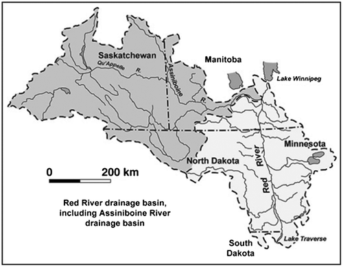
The largest tributary to the Red River is the Assiniboine River, which starts in eastern Saskatchewan and has a contributing area of approximately 162,000 km2 above its confluence with the Red River in the City of Winnipeg. The Assiniboine River has two major tributaries, the Qu’Appelle River (50,900 km2) which is located almost completely in Saskatchewan, and the Souris River which starts in Saskatchewan before crossing into the United States and returning to Canada near Westhope. The contributing area of the Souris River is approximately 61,100 km2, with 43,700 km2 being outside of Manitoba. In total, close to 60% of the area contributing to the Assiniboine River is located outside of Manitoba.
The nature of flooding is heavily influenced by the regional topography. The largest aerial extent of flooding occurs on the rich fertile lake plain that is the legacy of glacial Lake Agassiz. This affects the Red River’s morphology as the stream slope is extremely flat, with an average slope of approximately 0.005% from Emerson to Lake Winnipeg. The Red River Valley upstream of Winnipeg naturally becomes a massive reservoir during large floods. The “Red Sea” had a surface area of approximately 2000 km2 during the 1997 flood. Allowing the flood to spread provides a degree of natural attenuation for downstream communities.
The topography of the Assiniboine River basin is more diverse and complex. The river falls approximately 400 m from its headwaters in Saskatchewan to its confluence with the Red River, which is an average slope of 0.04%. The majority of this grade is within the upper reaches and it has approximately 30 m of grade in the last 150 km of river channel between Portage la Prairie and the City of Winnipeg, for an average slope of 0.02%.
The fact that close to 70% of the contributing area of the Red River is located outside of Manitoba has shaped flood response in that it has, out of necessity, been reactive rather than proactive. Flood mitigation that could be achieved by headwater storage, preservation of wetlands and land-use restrictions is to a large degree outside of Manitoba’s control, and flood control measures must deal with the consequences of flooding generated elsewhere.
All discussions of flood damage prevention in Manitoba begin with the 1950 flood, when a combination of deep winter snowpack and heavy rains during the snowmelt period caused the river to rise to a stage of 9.2 m (referenced to the “James Avenue datum” in downtown Winnipeg). This gauge is just downstream of the confluence of the Assiniboine and Red Rivers, and reflects all major flow input contributions to the Red River. The historical zero point for the gauge was the normal winter ice level and has been established as 221.766 m above mean sea level.
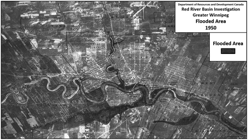
In 1950, minimum flood stage (5.5 m) was exceeded on 22 April, and the river remained above flood stage for 51 days. Over the course of the flood, 100,000 residents (one third of Winnipeg’s population) were evacuated from their homes, 10,000 homes were destroyed and 5000 buildings were damaged, although Winnipeg’s downtown ultimately escaped flooding. The area flooded within the current city boundary is shown in Figure . More than CAD $22 million was dispersed by the Manitoba Flood Relief Fund to aid flood victims, and nearly CAD $126 million was spent in dealing with flood damages (equivalent to about CAD $1.2 billion in 2014 dollars, using the Bank of Canada Inflation Calculator). In all its aspects – extent of damage, dislocation of people and economic impact – the 1950 flood was one of the largest natural disasters in Canadian history.
Figure 2. Extent of the 1950 Red River Flood – City of Winnipeg.
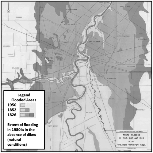
The 1950 Red River flood caused a dramatic change in attitude and policy on the part of the federal and provincial governments, which had previously regarded flooding as a local problem to be addressed by the affected municipalities. The flood of 1950 was a national disaster with an international dimension, as the flood became front-page news and flood aid was contributed from across North America. All levels of government realized that the potential existed for even greater disasters occurring in the future. This was especially true in light of the fact that larger floods had occurred historically. Figure illustrates the potential impact of the 1950 and historical floods. This eventually led to the construction of the Shellmouth Dam, Portage Diversion and dike works along the Assiniboine River. Flood protection works along the Red River included ring dikes around towns and individual flood protection mounds or dikes for individual farmsteads and the construction of the Red River Floodway around the City of Winnipeg.
Figure 3. Potential extent of Red River flooding – City of Winnipeg.
Chronology of flood protection works
Talks between the Province of Manitoba and the Canadian government on permanent flood protection works were initiated during the 1950 flood. In the short term, a federal–provincial agreement was concluded for the federal government to pay 75% of the estimated CAD $5 million cost to build a primary diking system and to construct pumping stations along the Red and Assiniboine Rivers to protect Winnipeg from flooding. Work commenced in September of 1950 to construct 48 km of elevated boulevard dikes along the rivers within the city, and 22 pumping stations. The diking system eventually formed a 110-km “primary line of defence” parallel to the rivers throughout the city. These dikes were designed as paved roads wherever possible, providing protection up to a stage of 8.05 m (about 1.2 m below the 1950 flood level) with the intention that they could be temporarily raised to 9.2 m if needed. This operational design water elevation was subsequently revised downward to 7.47 m to accommodate sewer outfalls and to provide a 0.6-m margin of safety. In some areas where there were problems of limited space or threats to bank stability, secondary dikes were constructed that could also be temporarily raised during emergencies.
Following the flood, the federal Department of Resources and Development created the Red River Basin Investigation (RRBI) to examine the history and causes of floods and to recommend possible ways of preventing them or mitigating the damages. The focus of the study was on the Red River and the prevention of flooding in Winnipeg, but the Assiniboine River was necessarily involved because it is the Red’s largest tributary and joins the Red at the “Forks” in downtown Winnipeg.
The flood control options available to the Investigation were limited by a number of circumstances. First, all large floods on the Red River originate beyond Canadian jurisdiction, in Minnesota and North Dakota in the United States, eliminating such measures as headwater storage or land management at the source area. Second, the greatest population and endangered infrastructure resides in Winnipeg where the riverbanks had been virtually completely occupied during the long, nearly flood-free interval from 1861 to 1950; as a result, most land-use options within the city were not economically or politically feasible. A third complication was the Assiniboine River, which joins the Red in downtown Winnipeg. Although it is a smaller river than the Red and its peak flows do not normally coincide, the Assiniboine has the potential to make critical contributions to Red River floods which cannot be controlled by flood protection measures on the Red. In 2011, the peak discharge measured on the Assiniboine River at Portage la Prairie (1700 m3/s) totaled approximately 50% of the natural peak discharge recorded on the Red at James Avenue (3285 m3/s).
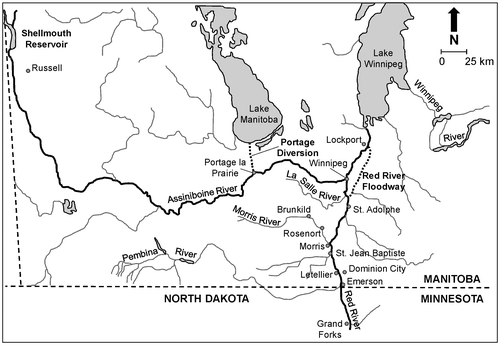
The RRBI (Citation1953) report proposed a number of possible solutions (Canada Department of Resources and Development Citation1953) but little action was taken until 1956, when the threat of another large flood spurred the appointment of a Provincial Royal Commission to examine the costs and benefits of the alternative schemes (Royal Commission Citation1958). As a result of the Royal Commission’s report, three large structural measures were constructed in the 1960s: the Red River Floodway, the Portage Diversion, and the Shellmouth Dam and reservoir (Figure ).
Figure 4. Location of major flood control structures in southern Manitoba.
All of these components were focused on preventing flooding in Winnipeg, but extensive flooding of the Red River Valley south of Winnipeg in 1966 led to the construction of ring dikes around eight communities in the valley, providing protection up to the 1950 level. Following a serious 1950-level flood in 1979, an extensive program of flood proofing buildings outside the ring dikes was established.
Red River Floodway
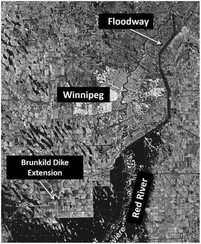
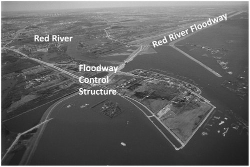
The Red River Floodway, the largest and most costly element of the system, is the most significant flood protection measure in Canada (Figures and ). The floodway is an excavated earthen, grass-lined channel which diverts a portion of the Red River flow in a 47-km loop around Winnipeg, from St. Norbert on the southern (upstream) edge of the city to Lockport, 18 km north of the city, where the water is spilled back into the Red River at a point where the channel is large enough to convey the flow from the original design event (4000 m3/s). The channel shows clearly on a Radarsat image of the 1997 flood.
Figure 5. Radarsat image of Red River Floodway.
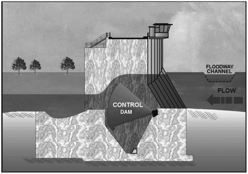
The entrance to the floodway is designed so that as Red River levels rise during a flood event, a portion of the flow spills over the floodway entrance. When this happens, the river water flows along two routes: through the city and through the floodway, as shown in Figure . This allows the upstream water level to be lower than it would have been without the extra capacity afforded by the floodway. When the floodway gates are raised, the water level south (upstream) of the floodway inlet is restored to its “natural level,” increasing the flow through the floodway.
Figure 6. Red River Floodway inlet structures.
This “natural level” is calculated taking into account any reductions in river levels afforded by the flood control works on the Assiniboine River. In other words, any reduction in flow due to either storage of water in the Shellmouth Reservoir or diversion through the Portage Diversion is considered in computing the water levels that would have existed before any of the flood protection works were constructed. The control structure gates rise from the bottom of the Red River, as shown in Figure .
Figure 7. Red River Floodway inlet control structure, showing gates in operating position.
Operation of the floodway reduces the flow in the Red River channel through the City of Winnipeg. A dike (the West Dike), extending for 34 km west of the river, prevents water from bypassing the floodway inlet control structure. In 1997, this dike was extended for an additional 34 km on an emergency basis (the Z-dike), and a modified version of the extension was made permanent as part of the post-1997 floodway expansion.
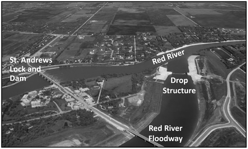
The floodway system’s estimated capacity was based on calculations that indicated that with a 0.5-m freeboard, the primary diking system within Winnipeg could contain a maximum river flow of 2265 m3/s and, in combination with the floodway capacity of 1700 m3/s, would be able to pass a total Red River flood flow of 3965 m3/s, which is about 30% larger than the 1950 flood. Moreover, when augmented by the Assiniboine River works, the proposed flood control system would be able to manage a combined Red and Assiniboine river flow of 4786 m3/s, a flood that was estimated to be reached about once every 165 years. The floodway re-enters the Red River downstream of the St. Andrews Lock and Dam, as shown in Figure .
Figure 8. Red River Floodway outlet structures.
Data collected during floodway operations allowed additional analysis to estimate the “ultimate capacity” of the floodway. This indicated that with the bridges in place, the floodway could pass 2500 m3/s, for a level of 237.13 m at the Floodway Inlet. This would require extreme operational measures including high forebay elevations, berm closures, minimal freeboard, etc. (see Appendix B: Preliminary Engineering Report, Floodway Channel Pre-design 2004).
The 1997 Red River flood tested the limits of the floodway’s capacity with flows of 1880 m3/s, which was approximately 10% higher than the original design flow, and the peak Red River flow allowed to pass the Floodway Control Structure was 2200 m3/s. The computed natural peak flow in the City of Winnipeg was approximately 4600 m3/s, which would indicate that the flood control works on the Assiniboine River reduced flows by approximately 600 m3/s. This is close to the original design flow and about 50% more than the 1950 flood. Re-computation of flood frequencies following the 1997 event reduced the return period for the design flow conditions to approximately the 1:100-year event. This was deemed to be an inadequate level of protection, and studies were undertaken to identify options to provide a higher level of flood protection.
The option selected was expansion of the floodway with the objective of being able to convey a 1:700-year flood event. Starting in 2005, Canada and Manitoba invested CAD $665 million to expand the “ultimate capacity” of the Red River Floodway from 2500 to 4000 m3/s. The capacities of other flood protection works would remain the same as before.
The original floodway was completed in 1968 at a cost of CAD $63 million. From 1968 to 2014, it has been operated to control many large floods, and is estimated to have prevented more than CAD $40 billion (in 2011 dollars) of flood damages in the City of Winnipeg.
The original floodway was the second largest earth-moving project in the world (second only to the Panama Canal and larger than the Suez Canal project). In 2000, the floodway was designated a National Historic Site. In 2008, it was named by the International Association of Macro Engineering Societies as “one of the World’s engineering marvels” and, two years later, the Canadian Society for Civil Engineering recognized it as a National Historic Civil Engineering Site.
Portage Diversion
Second in cost and importance is the Portage Diversion, a 29-km excavated channel designed to divert up to 710 m3/s from the Assiniboine River about 3 km west of Portage la Prairie into Lake Manitoba near Delta Beach (Figures and ). The Diversion was built from 1965 to 1970 at a cost of CAD $20.5 million.
Figure 9. Portage Diversion – from the Assiniboine River to Lake Manitoba.
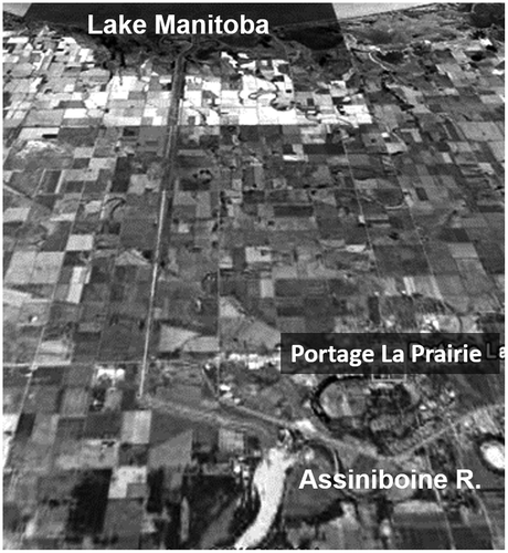
This channel was designed to reduce the contribution of the Assiniboine to the Red River within Winnipeg by diverting some (or even all) of its flow into Lake Manitoba. This increases the available hydraulic capacity of the Red River through the city. Although the purpose of the Assiniboine Diversion was to provide flood relief for Winnipeg, it has also provided invaluable protection for towns and rural buildings between Portage la Prairie and Winnipeg on several occasions, most notably in 1974, 1976 and 2011 (see Blais et al., Citation2015, this issue).
The reach of the Assiniboine River downstream of Portage la Prairie has a unique problem with regards to flooding. Deposition of stream sediment along parts of this stretch of the Assiniboine River has resulted in the river bottom being higher than the surrounding land surface. Diking began along the Assiniboine before the 1900s but did not become more widespread until after the floods of 1922 and 1923. In addition to diking, cutoffs were made through sharp river bends. The dikes were generally low and could not contain a major flood.
Prior to the construction of the dikes, flooding was a severe problem. When riverbanks were overtopped, many square kilometers of agricultural land would be flooded, often without the possibility of the water returning to the river when floodwaters receded. Even with dikes along both sides of the river, the Assiniboine River can only convey flows up to approximately 540 m3/s before spilling its banks. During operation, gates in a dam across the Assiniboine River are raised to restrict the downstream flow and the diversion gates are opened to allow water to flow towards Lake Manitoba.
During the flood of 2011, the capacity of the diversion channel was exceeded and was temporarily increased to 960 m3/s when it appeared that the flood peak would exceed the combined capacity of the Diversion and downstream Assiniboine River channel, creating a risk of uncontrolled overland flooding. This additional capacity was made possible by emergency improvements to the diversion’s dikes and structures.
Shellmouth Dam
The third major structural component of Manitoba’s flood protection infrastructure is the Shellmouth Dam on the upper Assiniboine River, 24 km northwest of Russell, Manitoba (Figures and ). It was constructed between 1964 and 1972 at a cost of CAD $10.8 million.
Figure 10. Shellmouth Dam and Lake of the Prairies Reservoir.
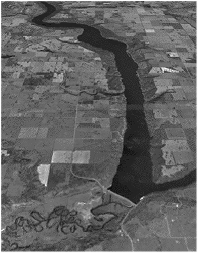
This earthfill dam offers further control over Assiniboine River flows, thus providing additional relief to Winnipeg but also contributing to flood control in Brandon, Manitoba. The dam, 21 m high and 1300 m long, impounds a 56-km-long reservoir known as Lake of the Prairies, where the river flows in a wide, deep, glacial spillway. At its full supply level, it can store 480 million m3. Outflows are controlled by a gated conduit and a 64-m-wide concrete chute spillway.
The reservoir level is lowered in the fall and winter to increase storage capacity for spring snowmelt. This storage not only reduces downstream Assiniboine flows during flood seasons, but can provide a conservation pool of water during dry years. When reservoir levels are very high, uncontrolled flows can spill over the concrete chute spillway and may cause flooding of downstream agricultural land in the valley bottom.
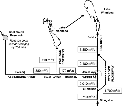
In combination, the primary dikes, Red River Floodway, Portage Diversion and Shellmouth Dam were designed to protect Winnipeg from floods up to 4786 m3/s (i.e. 65% greater than 1950). A representative routing of water during such a design flood is shown in Figure .
Figure 11. Theoretical routing of flow through the Lower Assiniboine and Red Rivers during the design flood, prior to 1997 improvements (adapted from Mudry, MacKay and Austford Citation1981).
Based on the 1958 frequency curves, a flood of 4786 m3/s had a return period of about 165 years at the time of the system’s completion. However, a series of post-construction high flows, with several floods of 1950s or greater magnitude, gradually altered the flow frequency curves such that by 1997, the so-called “flood of the century” had a discharge close to the design discharge but a frequency of only about 100 years. Improvements to the system after 1997 (mostly by enlarging the floodway) have increased the level of protection to about the 1:700-year event.
Red River community ring dikes
Ring dikes form an essential part of the flood protection infrastructure in the Red River Valley. Early studies of flood protection for the City of Winnipeg recognized that some measures could have an adverse impact on upstream communities. Due the geography of the valley and the distance between communities, comprehensive diking along the river is impractical and could cause more harm than good. Allowing the flood to spread out over the floodplain attenuates flood peaks and reduces water levels.
Between 1968 and 1972, dikes were constructed around eight towns within the floodplain (Brunkild, Emerson, Letellier, Dominion City, St. Jean Baptiste, St. Adolphe, Morris and Rosenort) at a cost of CAD $2.7 million, under the same federal/provincial cost-share program used to construct the other mitigation options described above. Initially, the ring dikes were constructed for protection from a 1950-magnitude flood (Figures and ), but subsequent floods, especially 1979 and 1997, provided the impetus for upgrading the protection level. Following the 1979 Red River flood, there was an additional federal/provincial program to flood proof individual homes and businesses to the height of the flood of record plus 0.6 m freeboard.
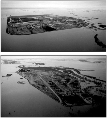
Figure 12. Ring dikes around (a) Morris, Manitoba, and (b) Roseau River First Nation.
The 1997 Canada–Manitoba Partnership Agreement on Red River Valley Flood Protection funded CAD $130 million in enhancements to the eight ring dike communities, provided for the construction of 10 more community ring dikes (Gretna, Rosenfeld, Riverside, St. Pierre-Jolys, Aubigny, Roseau River, Lowe Farm, Ste. Agathe, Niverville and Grande Pointe) and supported flood protection for homes, farms and businesses to the new flood protection level of 1997 levels, plus 0.6 m (2 ft). The ring dikes can be partially or fully closed during a flood. During the 2009 flood, the ring dikes prevented about CAD $700 million in flood damages to these communities.
Flood proofing of individual properties
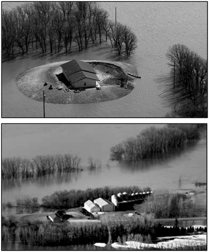
The final structural element in the flood protection scheme is an extensive program of flood proofing individual structures in the valley outside the ring dikes. The program was funded under a federal–provincial Special Damage Reduction Agreement after the 1979 flood. Under this agreement, assistance was provided to individual property owners to raise or ring dike their buildings (Figure ), and in some cases, the buildings were moved or purchased. After the 1997 flood, a further 1730 properties were protected.
Figure 13. Individual home protection – dikes of pads.
Winnipeg Flood Manual
The Flood Manual is a geographic information system (GIS)-based computer program linked to detailed databases that is used by City of Winnipeg employees to assist with flood protection procedures within the city. Developed after the 1997 flood, the manual computes water surface profiles for the rivers within Winnipeg based on provincial and city forecasts. Forecast river levels trigger actions and procedures by city personnel for activities related to pumping stations, flap gate closures on sewer outfalls, sealing of wastewater manholes, identification of homes that will require temporary flood protection measures, and sandbag counts, among others. The CAD $2.5 million initial investment is maintained and updated annually. The procedures help to facilitate and coordinate the many interrelated and necessary measures (~1200 activities associated with a flood of 6.86 m James Ave) that must be taken within the city to prepare for floods of various magnitudes (G. Mohr, pers. comm., 2014). The Flood Manual also helps to provide a level of continuity as key flood fighting personnel leave or retire.
A note on “natural flow”
With the Red River Floodway, Portage Diversion and Shellmouth Dam operating to manage total flows through Winnipeg during flood events, post-construction measurements of peak stage and discharge downstream of the structures are obviously smaller than uncontrolled, “natural” hydrologic events would produce. Consequently, when the control structures have been used, so-called “natural” stage and discharges are calculated to determine what the stages and discharges would have been at the James Avenue datum within Winnipeg, or on the Assiniboine River below Portage la Prairie in the absence of any controls – that is, without the operation of the three major control structures.
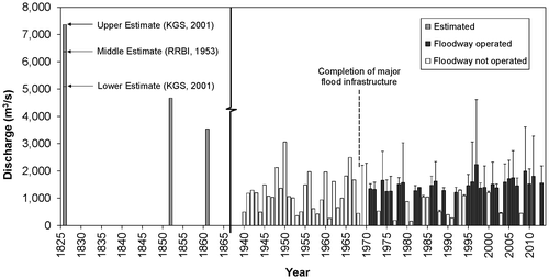
Computed “natural” values are not reported by Environment Canada. These are calculated by the Province of Manitoba independently of the data collected and reported by the Water Survey of Canada data for the Red and Assiniboine Rivers, although the flows through the two diversions are monitored and reported. Thus, users of the Red and Assiniboine data for the post-construction period (i.e. after 1972) must be aware of the distinction between the reported stage or discharge data in Winnipeg or on the lower Assiniboine and the computed “natural” values reflecting the uncontrolled, actual magnitude of the natural hydrologic event. Figure reports peak Red River flows within the City of Winnipeg. For the period after major infrastructure construction was complete, the computed natural peak flows are distinguished from the observed peak flows using whiskers above the bars. The gray bars denote years in which the floodway was operated, while white bars are years where it was not. However, the Portage Diversion and/or Shellmouth Dam could have contributed to a reduction in the peak flow even during years when the floodway was not operated and would thus appear as a whisker. The high frequency of flood infrastructure use, and the potential for significant peak flow reduction within Winnipeg, is apparent.
Figure 14. Historical record of Red River peak flows in Winnipeg.
Major floods in Manitoba
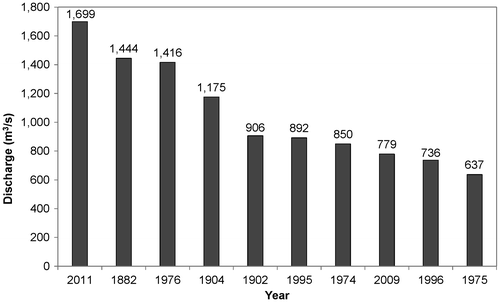
Flooding in Manitoba is not a new phenomenon. Figure presents flow estimates from three major historical floods that occurred in the 1800s. Of particular importance is the flood of 1826, which stands as the highest flood on record in Winnipeg. Since flow measurements were not taken during this event, computed flow estimates are based on high-water marks surveyed by Fleming (Citation1879). Due to the many sources of uncertainty in the recorded high-water marks, as well as many other possible complications (Rannie Citation2002, Citation2003, Citation2010) a range of flow estimates has been provided for these floods (RRBI Citation1953; KGS Group Citation2001). Figure summarizes the top 10 events for the Red at James Avenue for natural conditions, and Figure the top 10 flow events for the Assiniboine River at Portage la Prairie without flood protection works, since the early 1800s. Of special note is the fact that five of the top 10 floods on the Red River have occurred in the past 19 years, and when 2014 is included, four of the top 10 on the Assiniboine have occurred in the same period. In subsequent papers of this special issue, the 1997, 2009 and 2011 floods on the Red River as well as the 2011 and 2014 Assiniboine River floods will be assessed, including a discussion on the causes and damages incurred and prevented by flood protection infrastructure.
Figure 15. Top 10 peak flow events – Red River at James Avenue in Winnipeg.
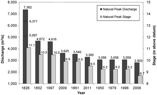
Figure 16. Top 10 peak flow events – Assiniboine River at Portage la Prairie, without flood protection works.
Conclusion
The impact of flooding in the Red River Valley has been greatly mitigated by the significant investment made by Manitoba and Canada over the past half century. The high cost of this flood protection (well in excess of CAD $1 billion in 2014 dollars) has been repaid many times over in the reduction of flood damages. Estimates of damage reduction range widely. At the upper end, Manitoba Conservation and Water Stewardship places the floodway’s damage reduction in Winnipeg at CAD $40 billion in 2011 dollars. Whatever the real number, all estimates agree that the control measures have repaid themselves many times over in damage reduction.
References
- Blais, E.-L., J. Greshuk, and T. Stadnyk. 2015. The 2011 flood event in the Assiniboine River Basin: Causes, assessment and damages. Canadian Water Resources Journal. doi:10.1080/07011784.2015.1046139.
- Canada Department of Resources and Development. 1953. Report on investigations into measures for the reduction of the flood hazard in the greater Winnipeg area (plus appendices). Red River Basin Investigation, Water Resources Division: Ottawa.
- Fleming, Sir S. 1879. Documents in reference to the bridging of Red River. Ottawa: Library of the Public Archives of Canada.
- KGS Group. 2001. Flood protection studies for Winnipeg. Appendix A, river hydraulics and flood damage potential downstream of floodway. Winnipeg: KGS Group/Manitoba Conservation.
- Mudry, N., G. H. MacKay, and V. M. Austford. 1981. Flood control and flow regulation problems on the Assiniboine River. Canadian Water Resources Journal 6(4): 157–173.
- Rannie, W. F. 2002. The role of the Assiniboine River in the 1826 and 1852 Red River flood. In Prairie perspectives: Geographical essays. vol. 5, ed. B. Thraves, 56–75. Winnipeg: University of Regina.
- Rannie, W. F. 2003. Some observations on peak stages during the 1826 Red River flood and the “Fleming Conundrum”. In perspectives: Geographical essays. vol. 6, ed. D. Eberts and D. Wiseman, 1–15. Winnipeg: Brandon University.
- Rannie, W. F. 2010. Could the Red River channel have been narrower in the early 19th century? In Prairie perspectives: Geographical essays. vol. 13, ed. D. Blair, 1–11.
- Red River Basin Investigation (RRBI). 1953. Report on investigations into measures for the reduction of the flood hazard in the Greater Winnipeg Area. Appendix B, History of floods on the Red River. Ottawa: Canada Department of Resources and Development, Engineering and Water Resources Branch.
- Royal Commission. 1958. Report of the Royal Commission on flood cost-benefit. Winnipeg, 129 pp.