
Abstract
In spring and summer of 2011, the Assiniboine River and its tributaries underwent a flood of unprecedented proportions. It was, by several measures, including the computed return period and duration of flooding, a more extreme event than the 1997 Red River “Flood of the Century,” and may have been the most severe flood experienced in the history of Canada. The 2011 flood was the largest recorded in the over 100 years that flow records have been kept on the Assiniboine River. As reported in the 2013 Manitoba 2011 Flood Review Task Force Report, antecedent conditions, winter snowpack and summer rains combined to produce one of the largest floods ever experienced in Manitoba. The spring of 2011 was preceded by a very wet fall in 2010 when precipitation averaged between 150 and 200% of normal over a wide area in Manitoba and Saskatchewan This produced extremely high regional antecedent moisture conditions whereby soil moisture levels were 100 to 250% of the long-term average. Added to this, the winter snowpack was relatively high, varying geographically in the range of 90 to 130% of normal snow water content and lower-than-normal winter temperatures, causing significant frost penetration. The combination of high soil moisture in the previous summer/fall and deep frost penetration reduced the soil’s ability to absorb spring meltwater and increased runoff volumes contributing to the magnitude of the spring peak. The severe winter was followed by a series of rainfall events that resulted in unprecedented rainfall volumes in the region throughout the months of May, June and July, when some areas received rainfall amounts that were 350% of normal and produced up to two additional flood peaks at some locations. Flooding on the Assiniboine River near Brandon lasted for 120 days. Large volumes of floodwater were diverted to Lake Manitoba due to the use of the Portage Diversion to mitigate flooding downstream of the City of Portage La Prairie. This large volume of inflow resulted in a wind-effect-eliminated Lake Manitoba level that peaked at 249.1 m in late July of 2011, which was close to 1 m higher than flood stage and almost 1.5 m higher than the top of the desirable range. Peak outflow from Lake Manitoba into the Fairford River was almost double historic maxima and resulted in Lake St. Martin levels that peaked in July of 2011 at 245.55 m, which was more than 0.6 m higher than the historic peak that occurred under natural conditions in 1955, and 1.4 m above flood stage. The damage estimate for this flood event has not been finalized but is likely in excess of CAD $1 billion. The majority of flood damages were incurred by communities and infrastructure along major tributaries like the Souris and Qu’Appelle Rivers, and the communities on Lake Manitoba and Lake St. Martin. The Lake St. Martin First Nations community was virtually destroyed, and as of 2014 some First Nations people from the communities along Lake St. Martin are still evacuated and waiting for their homes and communities to be rebuilt. Temporary flood control works were largely effective in preventing infrastructure damage to communities along the Assiniboine River, such as Brandon, although the agricultural damage and damage to individual properties were extensive.
Pendant le printemps et l’été de 2011, la rivière Assiniboine et ses affluents ont subit une inondation de proportions non-précéder. C’était, de plusieurs mesures, compris des calculs de la période de retour et la durée des inondations, un événement plus extrême que «l’inondation du siècle » en 1997 de la Rivière Rouge. Aussi, cette inondation était peut être la plus grave connu dans l’histoire du Canada. L’inondation de 2011 était la plus grande qui a été enregistrée, dans plus que 100 années que ces enregistrements de flux ont été maintenus sur la Rivière Assiniboine. Comme indiqué dans le rapport de Citation2013, Le rapport du détachement spécial de revue d’inondation du Manitoba 2011, des conditions antécédentes, les manteaux neigeux d’hiver et les pluies d’été ont combinés pour produire une des plus grades inondations connus au Manitoba. Le printemps de 2011 a été précédé par un automne humide en 2010, lorsque les précipitations moyennes ont été entre 150 et 200% de la normale, sur une large région du Manitoba et Saskatchewan. Ces précipitations avaient produit des conditions extrêmement élevées d’humidité antécédentes régionales, où les niveaux d’humidités de sol étaient de 100 à 250% de la moyenne à long terme. Ajouté à cela, le manteau neigeux de l’hiver a été relativement élevé, avec des variations géographiques dans la variation de 90 à 130% du teneur normal de l’eau dans la neige; et des températures hivernales plus bas que normales provoquant la pénétration du gel significatif. La combinaison de l’humidité du sol élevée en été/automne précédente et la pénétration du gel profond a réduit la capacité du sol à absorber de l’eau de font du printemps et l’augmentation des volumes de ruissellement contribuent à la magnitude du niveau maximum du printemps. L’hiver rigoureux a été suivi par une série d’événements de précipitations qui a résulté dans des volumes de précipitation sans précédence dans la région tout au long du mois de mai, juin et juillet, lorsque certaines régions ont reçu des quantités de précipitations qui ont été 350% de la normale et a produit jusqu’à deux pointes d’inondation supplémentaires à certains endroits. Les inondations de la Rivière Assiniboine près de Brandon ont duré 120 jours. De grands volumes d’eaux de crue ont été détournés vers le Lac Manitoba due à l'utilisation du canal de dérivation Portage, afin d'atténuer les inondations en aval de la Ville de Portage La Prairie, qui a abouti à un effet niveau du vent éliminé du lac du Manitoba. Ce grand volume d'écoulement a résulter dans un effet niveau du vent éliminé du lac du Manitoba, qui a culminé à 249.1 m à la fin de juillet 2011, qui était près d'un mètre plus haut que le niveau d'inondation, et apeurés 1.5 m de plus que le haut de la variation désirable. L’écoulement maximum du Lac du Manitoba vers la Rivière Fairford a été presque double le maximum historique et a résulté dans les niveaux maximum du lac Saint-Martin en juillet 2011 a un niveau de 245.55 m, qui était plus que de 0.6 m de plus que le niveau maximum historique qui se sont produit dans des conditions naturelles en 1955 et a 1.4 m de plus haut que le niveau d’inondation. L'estimation des dommages pour cette inondation n’est pas finalisée, mais c’est probable que ça soit en excès d’un milliard de dollard. La majorité des dommages de l’inondation ont été encourus par les communautés et infrastructure le long des affluents principaux comme les rivières Souris et Qu'Appelle, et les communautés sur le lac Manitoba et du lac Saint-Martin. La communauté de la Première Nation de Lake St. Martin a été pratiquement détruite et à partir de 2014, certains membres des Premières Nations des communautés le long du lac Saint-Martin continuent d’être évacués et attendent pour la reconstruction de leurs maisons et de leurs communautés. Des œuvres de contrôle des inondations temporaires ont été largement efficace dans la prévention des dommages aux infrastructures des communautés le long de la Rivière Assiniboine, comme Brandon, mais les dommages agricoles et les dommages aux propriétés individuels ont été extensif.
Geographical and hydrological setting
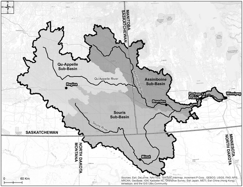
The Assiniboine River is the largest tributary of the Red River, with a gross drainage area of approximately 162,000 km2 at its confluence with the Red River. Only 25,000 km2 of the basin is within Manitoba, with the majority of the basin located in Saskatchewan and North Dakota. The main stem is approximately 1070 km in length.
It is important to note that most of the watershed resides within the prairie pothole region of the Canadian Prairies (Pomeroy et al. Citation2005; Fang et al. Citation2007Citation). This region has been affected by stagnant ice features from the last glaciation, which left the ground surface dotted with disconnected potholes or wetlands. Under natural conditions and depending on their size, depth and local hydrology, prairie potholes can be permanent or ephemeral. Each pothole tends to have a self-contained drainage area and acts as an independent drainage unit – until there is sufficient accumulated precipitation and runoff to fill the available storage, at which time water begins to spill into adjacent downstream catchments or water courses (Shook et al. Citation2013). As a result, a portion of the watershed around the potholes generally does not contribute flow to the watershed outlet in an average year, and is considered non-contributing area. Precipitation and runoff are stored within a pothole until removed by infiltration into the soil or evaporation, or discharged through a surface outlet. Pothole topography may also act to reduce the annual runoff volume by storing a portion of the runoff, providing an open water surface for evaporation and promoting infiltration into the groundwater system (Pomeroy et al. Citation2005).
The commonly accepted definition of non-contributing watershed area has been refined by several researchers. The Prairie Farm Rehabilitation Administration Watershed Project (PFRA Citation1983) formalized the hydrologic concepts of gross, effective and dead drainage areas for the prairies. The gross and effective drainage concepts originated with a paper by Stichling and Blackwell (Citation1957), who indicated that “contributing” drainage areas on the Canadian Prairies fluctuate by year, by season and by event because of the glacial landscape and the climate. Godwin and Martin (Citation1975, 119) restated Stichling and Blackwell's concepts of gross and effective drainage areas as follows:
The gross drainage area of a stream at a specified location is that plane area, enclosed by its drainage divide, which might be expected to entirely contribute runoff to that specified location under extremely wet conditions. The gross drainage boundary is the drainage divide (i.e. the height of land between adjoining watersheds).
The effective drainage area is that portion of a drainage basin which might be expected to entirely contribute runoff to the main stream during a flood with a return period of two years. This area excludes marsh and slough areas and other natural storage areas which would prevent runoff from reaching the main stream in a year of “average runoff.”
Large portions of the prairie pothole landscape are considered non-contributing using this definition; in other words, these areas would not discharge any surface runoff for the median event.
For the last 100 years, drainage networks have been extended in an attempt to improve drainage in these regions, by reducing the areas of ineffective drainage. Extension of drainage networks generally increases the area within a stream catchment contributing during more frequent events, and, all things being equal, this will increase the volume of water within the hydrologic cycle conveyed as surface runoff, and add to the flood peaks (Shook et al. Citation2013).
The effect of drainage improvements on flood peaks is less clear during an extreme hydrologic event. In these cases (the 2011 event, for example) antecedent conditions reduced the available live storage, and a greater proportion of the watershed would therefore be expected to contribute to the catchment outlet flow.
The hydrology of the prairie pothole region is complex and beyond the scope of this paper; however, the influence of man’s activities, both in changing the land use and extending the drainage network, undoubtedly plays a significant role in altering prairie hydrology and potentially increasing the magnitude of flood events.
The Assiniboine River basin has a gross area of 162,000 km2 to its confluence with the Red River and is subdivided into three major catchments: the Assiniboine River, the Qu’Appelle River (50,900 km2) and the Souris River (61,100 km2) (Agriculture and Agrifood Canada Citation2013), as shown in Figure . The Assiniboine River’s catchment can be further divided into the Upper Assiniboine River Basin, which is that portion of the Assiniboine River Basin upstream of the confluence of the Assiniboine and Qu’Appelle Rivers (gross area of approximately 21,000 km2), and the Lower Assiniboine below this point. The river’s headwaters are in eastern Saskatchewan.
Figure 1. Assiniboine River drainage basin (catchment areas from Agriculture and Agri-Food Canada Citation2013).
For much of its length, the Assiniboine River is contained within a large glacial meltwater channel, so flood damages are largely limited to the agricultural and other activities that take place along the valley bottom. The Shellmouth Dam was constructed within this channel between 1964 and 1972. The dam is located upstream of the confluence with the Qu’Appelle River, and created the Lake of the Prairies Reservoir. The dam was designed to provide downstream flood control and to augment low flows. The dam is 1270 m long and 22 m high. The reservoir is approximately 56 km long and has a total storage capacity of approximately 480,000 dam3 (equivalent to approximately the average annual inflow; 1 dam3 is 1000 m3). Outflows are controlled by a gated conduit and a 64-m-wide concrete chute spillway. The gross drainage area above the reservoir is 17,900 km2 (Upper Assiniboine Conservation District Citation2015).
The glacial meltwater channel extends from upstream of Lake of the Prairies to just upstream of the City of Portage la Prairie. From here, the river traverses the flat lake plain that was once the bottom of Lake Agassiz. In this reach, the low gradient and meandering nature of the river limit the channel conveyance capacity. Meanders add approximately 60% to the length of the river between Portage la Prairie and Winnipeg, with a proportional reduction in channel slope (Stunden Bower Citation2010) Over time, 134 km of dikes have been constructed along the Assiniboine River east of Portage la Prairie in an attempt to prevent agricultural damage. The dikes were first constructed by the federal government in 1912, reinforced in 1950 and again improved in the years following the 1997 flood (Manitoba Citation2015). Due to the extreme nature of the flood outlook, the Province of Manitoba again raised the dikes under emergency conditions prior to the 2011 flood. The dikes protect farmland, farms and residences as well as the communities of Elie, La Salle, Sanford and Starbuck, which would be affected if the Assiniboine River breached its banks.
The Portage Diversion diverts flow from the Assiniboine River to Lake Manitoba at a location approximately 3 km upstream of Portage la Prairie. The diversion was one of three major flood control measures constructed after the 1950 flood in Winnipeg, and is discussed in greater detail by Blais et al. (Citationthis issue). The diversion is operated to reduce flows on the Lower Assiniboine to the capacity of the channel and diking system. The capacity of the flood protection infrastructure was severely tested in 2011, as peak flow rates nearly exceeded the combined capacity of the Assiniboine River downstream of Portage la Prairie and a Portage Diversion channel that had been reinforced to allow flows nearly 40% larger than the design flow.
The operation of the diversion makes Lake Manitoba and its outlet part of the Assiniboine River Basin, acting as a secondary outlet. Lake Manitoba is Canada's 13th largest lake and the world's 33rd largest freshwater lake. The lake has a surface area of approximately 4700 km2, and has approximately 915 km of shoreline (The Lake Manitoba Regulation Review Advisory Committee Citation2003) and a catchment area of 79,800 km2 (Environment Canada Citation2015). The Fairford River is the only outlet from the lake, and it is controlled by the Fairford River Water Control Structure (FRWCS). The control structure and associated channel enhancement works were completed in the early 1960s, and significantly increased the ability to regulate lake levels as they provided more than twice the outflow capacity (380 vs. 150 m3/s) at the flood stage elevation of 248.1 m (KGS Group and AECOM Citation2011).
The Fairford River discharges into Lake St. Martin, which flows into the Dauphin River which then discharges into Lake Winnipeg. Operation of the FRWCS has resulted in adverse impacts to the First Nations on the shores of Lake St. Martin, since this lake’s outflow capacity was not increased at the time the FRWCS was constructed and remained at approximately 150 m3/s at flood stage. Lake St. Martin and the Dauphin River are also affected by frazil ice formation when high flows persist through the winter, resulting in a reduction in channel capacity and raised water levels along the Dauphin River back to Lake St. Martin.
Causes of the flood
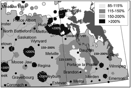
In spring and summer of 2011, the Assiniboine River and its tributaries underwent a flood of unprecedented proportions. The conditions leading to this event began the previous summer when much of the basin received rainfall amounts that were generally 150–200% of normal as shown in Figure . (Agriculture and Agri-Food Canada [AAFC] Citation2010). The wet summer was followed by the “weather bomb” in October 2010 that dumped 50 to 100 mm of rain and/or snow across the southern Prairies (Environment Canada Citation2011). The high soil moisture at freeze-up, above-normal winter snowpack, additional snow and rain during the spring freshet, and heavy summer rain events all combined to produce several large runoff events. In early May of 2011, rivers and creeks in the basin were over flood stage, including the Assiniboine, Qu’Appelle and Souris Rivers, with all-time-record flood peaks being experienced at many locations in the Assiniboine River Basin.
Figure 2. Prairie antecedent precipitation (August to October; 2010 inclusive) as a percent of normal.
Winter precipitation
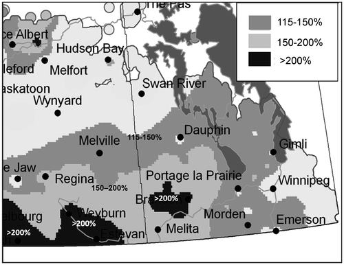
The winter of 2010–2011 produced above-average snow accumulations over much of the basin that had already been subjected to extreme rainfall amounts through the summer and fall of 2010 with precipitation up to 150% of normal. Southwest Manitoba and southeast Saskatchewan also received several major rain systems that tracked across the prairies in late April and May of 2011, resulting in extreme rainfall amounts over the basin producing record high-water levels on lakes and rivers, and a loss of crops across large portions of the basin. At least four major rain storms and a number of smaller events occurred over the basin and as far as the Interlake region of Manitoba, in May and June of 2011. Each of these events had rainfall maxima in the range of 100–150 mm, but of course the amounts varied greatly over the basin. The spatial extent of these precipitation systems was important in contributing to flooding on Lake Manitoba and Lake St. Martin. Rainfall amounts recorded for Souris during this period were 216 mm or about 300% of normal. Rainfall totals for the period between 1 April and 1 June are shown as a percentage of normal in Figure . These events affected a large proportion of the Assiniboine River basin and resulted in multiple flood peaks along many of the tributaries.
Figure 3. Rainfall amounts for the period between 2 April and 30 June expressed as percentage of normal.
The course of the flood – Assiniboine River
The first flood peak along the Assiniboine River was generated by a combination of snowmelt and some rainfall, and occurred in early May. Due to the influence of the major tributaries, flooding along the Assiniboine can sometimes be contained to particular reaches of the river without affecting the whole river system. This was not the case in 2011, as all tributaries and the entire Assiniboine River were affected by flooding at some time during the 2011 event. The operation of various permanent or temporary flood control works acted to reduce the severity of the flooding along various reaches of the river.
Upper Assiniboine – Lake of the Prairies Reservoir
The 2011 spring peak was the largest recorded in the Upper Assiniboine. Peak inflows to the Lake of the Prairies reservoir were estimated by Manitoba Infrastructure and Transportation (MIT) to between 475 and 600 m3/s (Manitoba Citation2011). The data collected by MIT indicates that the peak outflow from the reservoir was approximately 350 m3/s, which would mean that reservoir storage at Shellmouth reduced the 2011 peak at the Water Survey of Canada (WSC) gauge near Russell gauge by 22% (400 m3/s after accounting for local inflows). This is equivalent to a water level reduction of approximately 0.55 m.
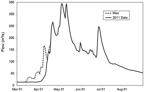
The Qu’Appelle River joins the Assiniboine River downstream of the Shellmouth Dam near the town of St. Lazare, Manitoba. The gauge near Welby, Saskatchewan, the furthest downstream on the Qu’Appelle River before the confluence, exhibited multiple peaks in 2011, as illustrated in Figure , as successive rainfall events occurred within the catchment. The peak flow in early May, of 345 m3/s, was nearly 40% larger that the previously recorded maximum and, equally important, the annual volume of runoff was almost double the estimated previous maximum.
Figure 4. Flows recorded on the Qu’Appelle River near Welby, Saskatchewan.
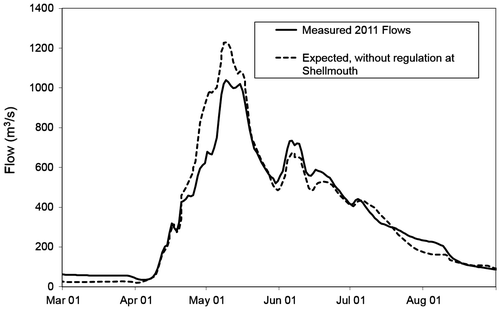
The largest city along the Assiniboine River is Brandon, Manitoba. The spring flood outlook provided by the Manitoba Hydrologic Forecasting Centre had indicated a high probability for a major flood event, and the City and Province had implemented temporary flood protection works that prevented most of the potential infrastructure damage. Flow records have been kept in or near the City of Brandon since 1906. The spring peak of 1040 m3/s, as shown in Figure , was 60% higher than the previous high event recorded in 1923. The river was nearly 7 m higher than normal and 20 to 30 times wider in some places. Flooding on the Assiniboine near Brandon lasted for 120 days. MIT staff estimated that the storage effects at the Shellmouth reservoir reduced the expected peak flows within the Assiniboine River near Brandon from 1250 m3/s to 1050 m3/s, or a 16% reduction, as shown in Figure (Manitoba Citation2013).
Figure 5. Effects of regulation at Shellmouth on 2011 flows at Brandon (Manitoba 2011 Flood Review Task Force Report Citation2013).
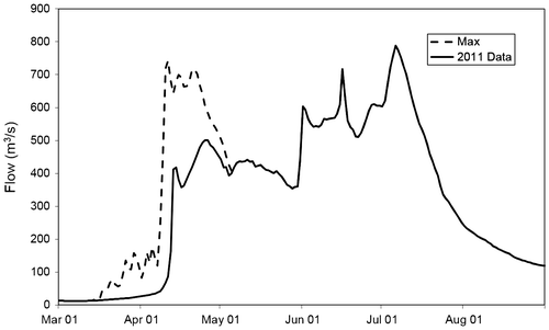
The Souris River joins the Assiniboine River downstream of Brandon. The Souris can display two peaks because of its long flow path and numerous reservoirs within its catchment area. The first peak is generated from “local flow” within Manitoba, and the second is generated from runoff originating in Saskatchewan and North Dakota. In 2011, the Souris exhibited three major peaks, with the last two due to rainfall events. Each successive peak was larger than the last. The final peak exceeded all previous recorded events for the gauge at Wawanesa, and did not occur until early July, as shown in Figure . The recorded peak flow of approximately 790 m3/s was higher the previous recorded maximum of 740 m3/s in 1976, and total annual runoff in 2011 was more than twice the previous maximum recorded.
Figure 6. Flows recorded on the Souris River at Wawanesa, Manitoba.
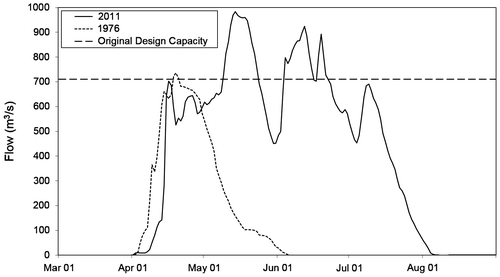
The reach of the Assiniboine River downstream of the confluence with the Souris River also experienced three flood peaks, as recorded at the WSC gauge near Holland, Manitoba, with all three peaks being of similar magnitude, as shown in Figure . The hydrograph for the previous recorded maximum flow event in 1976 is included to provide context for the 2011 event. The last peak was, to a large degree, the result of flows on the Souris River where major flood control reservoirs, including Rafferty, had reached full supply by mid-June. This resulted in peak flows of over 800 m3/s in late June entering North Dakota and eventually being conveyed back into Manitoba. This flow rate was approximately double the previous maximum recorded for the gauge near Sherwood, Saskatchewan, based on 83 years of data.
Figure 7. Flows recorded at the Assiniboine River near Holland.
Portage Diversion
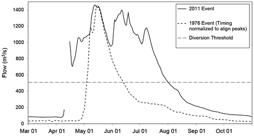
The Portage Diversion is located downstream of Holland and upstream of Portage la Prairie. The design capacity of the Portage Diversion in 2011 was 700 m3/s. Due to the magnitude of the flood event, emergency construction works were undertaken to raise the dikes along the diversion and reinforce the drop structures to increase the capacity to approximately 1000 m3/s. There were also concerns about the capacity of the Assiniboine River downstream of Portage la Prairie, and emergency work was undertaken in the late winter to bolster dikes based on the flood outlook.
Early in the flood, it was identified that even with the work undertaken to the diking system, significant seepage and risk to the dikes remained when the flow exceeded approximately 500 m3/s, as shown in Figure . All flow exceeding this threshold had to be diverted, or risk an uncontrolled dike breach. This had several consequences, including attempting (successfully) to divert water down the Portage Diversion at 40% over the design capacity and undertaking contingency planning in case the combined capacity of the Portage Diversion and Lower Assiniboine River were exceeded. The selected option for this contingency was the construction of an emergency spillway through a dike road, and is discussed below (in the section “Controlled breach”). Figure illustrates the flow through the Portage Diversion in 2011, and includes the previous record 1976 event and the original design capacity for context.
Figure 8. Flow rates through the Portage Diversion.
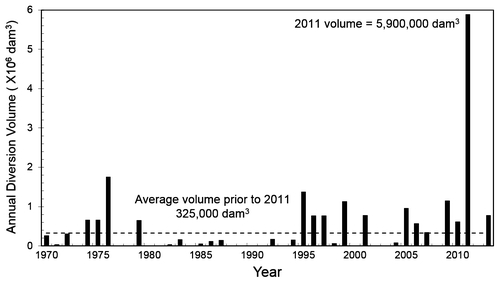
Prior to the 2011 flood, the annual diversion volumes ranged from zero (diversion not operated) to a high of 1,760,000 dam3 in 1976, with an average annual volume of 325,000 dam3, as shown in Figure . During the operating period in 2011, the Portage Diversion flow averaged 710 m3/s over a period of 130 days, peaking at 980 m3/s in the middle of May. The diversion discharged approximately 5,900,000 dam3 into Lake Manitoba, accounting for about 50% of the total inflow into Lake Manitoba. This volume was more than 3 times the next highest diverted volume, which had occurred in 1976, and is roughly equivalent to 1.2 m of water over the normal surface area of the lake.
Figure 9. Annual diversion volumes to Lake Manitoba via the Portage Diversion (Manitoba 2011 Flood Review Task Force Report Citation2013).
Controlled breach – “Hoop and Holler”
The maximum forecast peak flow on the Assiniboine River at the Portage Diversion during the 2011 event was 1590 m3/s. Given that the capacity of the Portage Diversion, after dikes were raised and drop structures reinforced, was increased to 1000 m3/s, and that the dikes on the Assiniboine River downstream of the diversion could accommodate at most 500 m3/s, there was approximately 100 m3/s of conveyance that could not be managed by the existing flood control works. Attempting to pass this additional flow rate through the Lower Assiniboine River or along the diversion was expected to result in an uncontrolled breach.
The alternative was to construct an emergency spillway that could divert water out of the Assiniboine River across the prairie and into local Red River tributaries such as the Elm or La Salle Rivers. The method used to construct the spillway was to armour a section of a dike so that the dimensions of the opening could be controlled, and thus control the flow rate. The location chosen for the breach was located at a bend of Highway 331, locally called the Hoop and Holler bend. The uncertainty surrounding the planned breach was that it was not clear when (or if) the breach would be needed, or the extent of flooding that would result. The breach was opened on Saturday 14 May due to flows at critical levels on both the Portage Diversion and the Lower Assiniboine River, and Environment Canada weather forecasts indicating additional rain that would increase inflows further.
A controlled breach of the dike in the range of 2000 to 6000 cfs was predicted to flood approximately 225 km2 of farmland. This option was chosen as opposed to risking an uncontrolled breach, which could flood as much as 500 km2 with flows of up to 15,000 cfs (420 m3/s), while over 800 homes would be affected by the waters (Manitoba Citation2011).
The rain event did not occur and the upstream flows at the gauge near Holland peaked at approximately 1470 m3/s (8% lower than the forecast peak). Only a small amount of water moved through the breach, and the breach was closed Friday 20 May, resulting in the flooding of less than 5% of the predicted area.
Effects on Lake Manitoba and Lake St. Martin
Lake Manitoba is regulated in an attempt to keep levels between 247.04 m and 247.65 m, with flood stage being defined as 248.11 m. The inflows to Lake Manitoba in 2011 were the highest on record for both the Waterhen River (its largest tributary) and the Portage Diversion, as shown in Figure . Between January and the beginning of April, the lake levels were relatively stable as the FRWCS outflows were similar to the Lake Manitoba inflows. The lake levels began to rise rapidly in the second week of April due to the rising inflows from the Waterhen River, the Whitemud River and the Portage Diversion. Lake inflows peaked in early June, at approximately 1450 m3/s.
Figure 10. Annual inflows into Lake Manitoba since construction of the Portage Diversion (Manitoba 2011 Flood Review Task Force Report Citation2013).
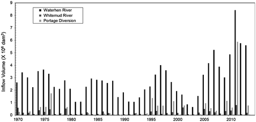
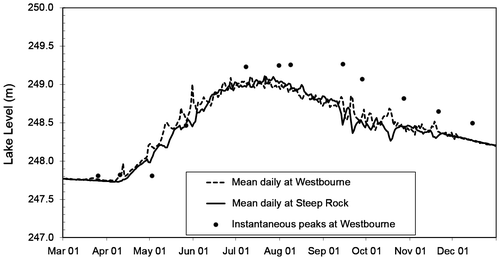
Figure illustrates the lake levels measured at the two WSC gauges on the lake, and the observed instantaneous peak levels in the south basin of the lake. On 31 May, winds in excess of 100 km/hr from the northwest produced a lake setup of 0.65 m at Westbourne, raising the lake level in the vicinity to 249.35 m. The instantaneous peak level at Twin Lakes Beach on the southeast side of the lake reached 250.04 m, almost 1.5 m above the ambient lake level, due to wind setup and waves reported to be as high as 2.1 m. Areas around the lake that were hardest hit include the rural municipalities of St. Laurent, Woodlands, Alonsa and Portage la Prairie, and the First Nations communities of Lake Manitoba and Sandy Bay.
Figure 11. 2011 Water levels on Lake Manitoba (Manitoba 2011 Flood Review Task Force Report Citation2013).
Outflows through the FRWCS into the Fairford River peaked at approximately 650 m3/s in late July, coincident with Lake Manitoba peak levels. In the same manner as most large lakes, the water levels measured at a location are constantly changing due to the wind transferring water to the lee or downwind shore. For this reason, an estimate of the wind-effect-eliminated lake levels, or ambient lake level, is made using data from multiple gauges or other smoothing techniques. Lake Manitoba levels peaked at 249.1 m in late July of 2011, or about 1 m higher than flood stage and almost 1.5 m higher than the top of the desirable range. Instantaneous peak water levels due to wind effects were typically 0.25 to 0.5 m above the ambient lake level. Wind events occurred in virtually every open-water month. Lake Manitoba levels did not drop below flood stage until late January 2012, and did not recede to the top of the desirable range (247.65 m) until September of 2012.
Lake St. Martin
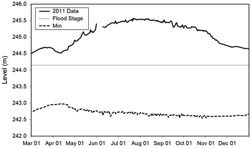
Lake St. Martin levels peaked in July of 2011 at 245.55 m, as shown in Figure . This was more than 0.6 m higher than the historic peak that occurred under natural conditions in 1955, and 1.4 m above flood stage. Although the recession was aided by the construction of an emergency outlet channel in the fall of 2011, Lake St. Martin levels were above flood stage until July of 2012. The Lake St. Martin Emergency Outlet Channel was constructed under temporary approval and was closed in November 2012, at which time lake levels again rose to above flood stage, and the lake has stayed above flood stage except for a short period in the spring of 2013.
Figure 12. Lake St. Martin recorded levels.
Flood damages
Flood damage varied throughout the Assiniboine River Basin, with significant local flooding as tributaries reached their highest recorded levels and flows. A firm cost estimate has not yet been produced; however, the Province of Manitoba indicated that damages in Manitoba were in excess of CAD $1 billion. Part of the problem in estimating damage costs is in the responsibility for paying for the damages, and the fact that some damages are not eligible under the Disaster Financial Assistance Arrangements (DFAA) program and may not have been included in total damage estimates. In some cases, such as crop damage, the cost may be borne by other institutions and not directly included in damage estimates.
During the flood, more than 650 roads and nearly 600 bridges were damaged, disrupting transportation networks across the province. Most of the cost of repairing the provincial roads and bridges damaged by the flood would be borne by the Province and Canada through disaster assistance funding. Significant other costs due to both direct damage and “collateral damage” to municipal infrastructure have also placed an immense burden on municipalities.
Although major damages to the City of Brandon were averted, the flood did cause significant areas of the city to have restricted access, and caused a major financial impact on the businesses within the flood zone as they were shut down during much of the flood’s duration.
The worst impacts of the flood were to the communities on the shores of Lake Manitoba, Lake St. Martin and the Dauphin River. Many homes and businesses were destroyed, and people displaced. First Nations community members numbering in the thousands are still displaced 3 years after the event, and at least one community has been completely destroyed. Rebuilding First Nations infrastructure will cost hundreds of millions and has not yet been accounted for in damage estimates.
Return periods
Table and Figure summarize the severity of the flood peaks and runoff volumes at selected locations throughout the Assiniboine River Basin. The values presented were estimated by Manitoba Conservation and Water Stewardship staff using data collected by either Manitoba Government or Environment Canada staff. The results were presented in the Manitoba 2011 Flood Review Task Force Report (Citation2013). An example of the statistical distribution was provided for Dauphin Lake, where it was indicated that a Pearson Type III distribution was used. It is probable that the same distribution was used for all analyses. The table provides an indication of the return period of various facets of the 2011 event.
Table 1. Severity of the 2011 flood at locations in Manitoba.
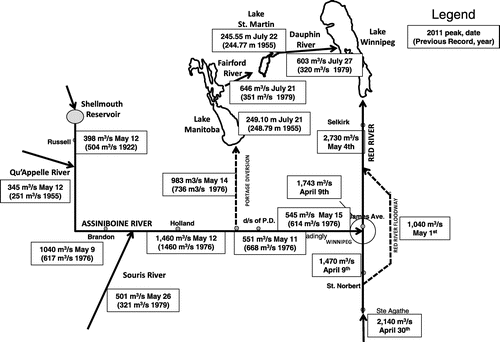
Figure 13. Assiniboine River Basin flows or levels at select locations relative to the previous peak event.
Lake Manitoba and Lake St. Martin are not included in the table. Due to rigid controls of Lake Manitoba levels over the past 50 years, the peak water levels are not amenable to a straightforward statistical analysis. Lake Manitoba reached record levels due to several factors. The above-average precipitation in 2010 and 2011 over much of the catchment contributed to high water levels on Lake Winnipegosis, and high outflows on the Waterhen River which is the largest natural stream entering Lake Manitoba. The largest contributor to Lake Manitoba levels was the volume of inflows from the Portage Diversion. Unprecedented volumes of water were diverted into Lake Manitoba due to the high magnitude and long duration of flood flows on the Assiniboine River. Many of the residents around Lake Manitoba see the operation of the diversion as creating an artificial flood. Lake St. Martin also experienced record high-water levels because of the high outflows from Lake Manitoba at Fairford. Manitoba Water Stewardship staff have estimated that the peak wind-effect-eliminated water level on Lake Manitoba had a return period of 1:400 years.
Summary
The 2011 flood event on the Assiniboine River and its tributaries started with the spring freshet in late April and early May, and continued for approximately 3 months as successive weather events brought record rainfall amounts over a large proportion of the basin. Extreme flood conditions were experienced over the entire length of the Assiniboine, Qu’Appelle and Souris Rivers, and along many tributaries. Record runoff amounts were recorded in the Assiniboine and Lake Manitoba basins, which combined to produce the highest water levels experienced on Lake Manitoba and downstream rivers and lakes.
Judged on the spatial and temporal scale of this flood event and the extremely low probability of occurrence, the 2011 “Assiniboine River Flood” may be the most extreme flood event experienced in Canada. It can be argued that the impacts of this event are still being felt on Lake St. Martin 3 years later, where levels have only been below flood stage for a few months, due to efforts to bring down Lake Manitoba levels, and many First Nations people cannot return home until new communities are constructed.
References
- Agriculture and Agri-Food Canada (AAFC). 2010. Drought watch. Agriculture and Agri-Food Canada’s national agroclimate information service (NAIS). www.agr.gc.ca/drought (accessed March, 2015).
- Agriculture and Agri-Food Canada (AAFC). 2013. Gross and effective drainage areas for hydrometric gauging stations of the AAFC Watersheds Project – 2013. http://open.canada.ca/data/en/dataset/063ee9b6-b3f2-45ab-9bed-d330880064d5 (accessed March, 2015).
- Blais, E., S. Clark, K. Dow, B. Rannie, T. Stadnyk, and L. Wazney. This issue. Background to flood control measures in the Red and Assiniboine River Basins. Canadian Water Resources Journal. doi: 10.1080/07011784.2015.1036123
- Environment Canada. 2011. Canada's top ten weather stories for 2010. https://www.ec.gc.ca/meteo-weather/default.asp?lang=En&n=47397091-1 (accessed March, 2015).
- Environment Canada. 2015. Historical hydrometric data. https://wateroffice.ec.gc.ca/mainmenu/historical_data_index_e.html (accessed March, 2015).
- Fang, X., A. Minke, J. Pomeroy, T. Brown, C. Westbrook, X. Guo, and S. Guangul. 2007. A review of Canadian Prairie hydrology: Principles, modelling and response to land use and drainage change. Saskatoon, SK: Centre for Hydrology, University of Saskatchewan.
- Godwin, R. B., and F. R. J. Martin. 1975. Calculation of gross and effective drainage areas for the Prairie Provinces. In Canadian hydrology symposium – 1975 Proceedings, 11–14 August 1975, Winnipeg, Manitoba, 219–223. Associate Committee on Hydrology, National Research Council of Canada, Ottawa.
- KGS Group and AECOM. 2011. Options for emergency reduction of Lake Manitoba and Lake St. Martin Levels. Winnipeg: KGS Group and AECOM.
- The Lake Manitoba Regulation Review Advisory Committee. 2003. Regulation of water levels on Lake Manitoba and along the Fairford River, Pineimuta Lake, Lake St. Martin and Dauphin River and related issues. Report to the Minister of Conservation. http://www.gov.mb.ca/waterstewardship/reports/lake_manitoba/water_levels_main2003-07.pdf (accessed March, 2015).
- Manitoba. 2011. Flood Bulletins 1-98. Government of Manitoba. March–August 2011.
- Manitoba. 2013. 2011 flood: Technical review of Lake Manitoba, Lake St. Martin and Assiniboine River Water Levels. Manitoba Government Publication.
- Manitoba. 2015. Flooding in Manitoba. http://www.gov.mb.ca/flooding/fighting/index.html (accessed March, 2015).
- Manitoba 2011 Flood Review Task Force. 2013. Report to the Minister of Infrastructure and Transportation plus appendices, April, 2013. Manitoba Government Publication.
- Pomeroy, J. W., D. de Boer, and L. W. Martz. 2005. Hydrology and water resources of Saskatchewan. Centre for Hydrology: University of Saskatchewan, Saskatoon.
- Prairie Farm Rehabilitation Administration (PFRA) Hydrology Division. 1983. The determination of gross and effective drainage areas in the Prairie Provinces. Hydrology Report #104, Agriculture Canada, Regina, SK: PFRA Engineering Branch, 22 pp.
- Shook, K., J. W. Pomeroy, C. Spence, and L. Boychuk. 2013. Storage dynamics simulations in prairie wetland hydrologymodels: Evaluation and parameterization. Hydrological Processes 27: 1875–1889.
- Stichling, W., and S. R. Blackwell. 1957. Drainage area as a hydrologic factor on the glaciated Canadian Prairies. IUGG Proceedings, Volume 111, Toronto, ON: IUGG, 12 pp.
- Stunden Bower, S. 2010. Natural and unnatural complexities: Flood control along Manitoba’s Assiniboine River. Journal of Historical Geography 36: 57–67.
- Upper Assiniboine Conservation District. 2015. http://www.uarcd.com/PDFs/WPAT_PRESENTATION_Shellmouth_Oct_18_.pdf (accessed March, 2015).