
Abstract
Groundwater contributions to streams often vary both spatially and temporally. In this study, the relative contributions of groundwater to Fishtrap and Bertrand Creeks in the Lower Fraser Valley are compared during the summer and annually using a combination of methods. The streams drain watersheds that have a similar climate, area and topographic relief. However, the geological substrate differs, with finer grained material underlying Bertrand Creek. A simplified heat budget model is first used to estimate temperature at the air–water interface. Then, the correlation between the air–water and bed–water (interface) temperatures is compared for both annual and summer periods in each stream. The air temperature explains ~30% of the variance in the summer interface temperature in Fishtrap Creek, but more than 75% in Bertrand Creek. This difference suggests that factors at the bed–water interface influence the heat budgets, and that these factors differ between the two sites. The measured groundwater flux during the summer periods was higher in Fishtrap Creek than in Bertrand Creek, due to a higher vertical hydraulic gradient into the stream and higher aquifer sediment permeability. Thus, the larger groundwater contribution to Fishtrap Creek moderates stream temperature and stream discharge during the summer periods, whereas Bertrand Creek has greater potential for elevated stream temperatures and lower flows during the critical summer period The combination of methods used in this study strengthens the interpretations given the wide range of uncertainty in measurements.
Les contributions des eaux souterraines aux cours d’eau varient souvent à la fois spatialement et temporellement. Dans cette étude, les contributions relatives estivales et annuelles des eaux souterraines de Fishtrap Creek et Bertrand Creek, deux cours d'eau situés dans la Vallée du Bas Fraser, ont été comparées en utilisant une combinaison de méthodes. Les cours d’eau s’écoulent de bassins versants ayant un climat, une superficie et un relief topographique similaires. Seul le substrat géologique sous-jacent de Bertrand Creek diffère et présente des matériaux plus finement grainés. Un modèle de bilan thermique simplifié a d'abord été utilisé pour estimer la température à l'interface air–eau. La corrélation entre les températures air–eau et eau–lit (interfaces) a été ensuite comparée sur des périodes annuelles et estivales, pour chacun des cours d’eau. En été, la température de l'air explique environ 30% de la variance de la température de l'interface pour Fishtrap Creek, mais plus de 75% pour Bertrand Creek. Cette différence suggère que des facteurs à l'interface eau–lit influencent les bilans thermiques et que ceux-ci diffèrent entre les deux sites. Le flux d'eau souterrain mesuré pendant les périodes d'été est plus important pour Fishtrap Creek que pour Bertrand Creek, en raison d'un gradient hydraulique vertical supérieur dans le cours d’eau et une perméabilité supérieure de l’aquifère sédimentaire. Ainsi, la contribution des eaux souterraines de Fishtrap Creek étant plus importante, elle pondère la température et le débit du cours d'eau pendant les périodes d'été, alors que Bertrand Creek possède un plus grand potentiel pour des températures des cours d'eau élevées et des débits plus faibles au cours de la période critique estivale. Etant donné l'amplitude de l'incertitude liée aux mesures, la combinaison des méthodes utilisées dans cette étude renforce les interprétations.
Introduction
Groundwater is an important component of streamflow (baseflow) throughout the year in many streams, but during the summer low flow period, stream flow is often sustained by groundwater influxes (Winter et al. Citation1998; Smakhtin Citation2001; Hatch et al. Citation2006). Summer is also a critical period for aquatic habitat, because the warming associated with higher air temperature and low streamflow may cause critical thresholds (flow and stream temperature) to be reached for many aquatic species (Nelitz et al. Citation2007; Burn et al. Citation2008; Cunjak et al. Citation2013). Groundwater influxes to streams, however, have the ability to buffer these impacts by: (1) maintaining water levels (stream discharge) (Fleckenstein et al. Citation2004; Beatty et al. Citation2010), (2) providing thermal refugia (Hayashi and Rosenberry Citation2002; Caissie Citation2006; Kanno et al. Citation2014; Kurylyk et al. Citation2014) and (3) supplying nutrients and inorganic matter (Power et al. Citation1999), each being important to aquatic health. Therefore, understanding what factors influence the degree to which groundwater interacts with streams is important for the management of streams, riparian habitats, and water use (Brewer Citation2013; Kanno et al. Citation2014).
A variety of methods can be used to characterize groundwater–surface water interactions at different spatiotemporal scales. These include direct methods for measuring exchanges between groundwater and surface water, indirect methods and combinations of both (Cey et al. Citation1998; Jones and Mulholland Citation2000; Essaid et al. Citation2008; Rosenberry and LaBaugh Citation2008). Direct methods include seepage meters, piezometers and stream flow measurements (Boulton Citation1993; Baxter et al. Citation2003; Rosenberry Citation2008). Indirect methods include indicators such as water chemistry and mixing properties, or tracers such as heat (Stonestrom and Constantz Citation2003; Anderson Citation2005; Malcolm et al. Citation2005; Constantz Citation2008). These various field methods have limitations, and the choice of field method(s) utilized must be appropriate for the spatial and temporal scale of the investigation (Cey et al. Citation1998; Kalbus et al. Citation2006).
Temperature is considered a robust and easily measured parameter to assess groundwater interactions with surface water. At depths below a few metres, at which there is practically no annual fluctuation in ground temperature, groundwater temperatures remain relatively stable throughout the year, with values 1–2°C higher than mean annual air temperature, at least in the absence of deep seasonal snowpack (Meisner et al. Citation1988; Zhang Citation2005). The fluctuations in groundwater temperatures are also much less pronounced than the diurnal and seasonal fluctuations in surface water temperatures, which are known to respond strongly to patterns in air temperatures and solar radiation (Johnson and Jones Citation2000; Johnson Citation2003; Moore et al. Citation2005; Caissie Citation2006). Stream temperature variations have been used as a proxy for identifying groundwater fluxes to streams, and in combination with other field methods have been employed as a tracer to quantify water exchanges (Silliman and Booth Citation1993; Stonestrom and Constantz Citation2003; Becker et al. Citation2004; Conant Citation2004; Anderson Citation2005; Kalbus et al. Citation2006; Schmidt et al. Citation2006; Arrigoni et al. Citation2008; Constantz Citation2008; Hebert et al. Citation2011; Caissie et al. Citation2014). For streams showing attenuated temperature variations both diurnally and seasonally, temperature has been used to identify the relative flux of groundwater to the channel, and relative contributions are useful for site comparisons (Stonestrom and Constantz Citation2003; Moore et al. Citation2005; Caissie Citation2006).
Both regression and stochastic approaches have been used to predict the thermal regime of a stream using air temperature as a predictor given the correlation between air temperature and stream temperature (e.g. Stefan and Preud’homme Citation1993). Deterministic models have also been used (e.g. Caissie et al. Citation2014). For example, to aid in the understanding of fluxes, a simple heat budget for a stream can be calculated from the combination of energy fluxes at the water–air interface and the water–bed interface (Sinokrot and Stefan Citation1993; Webb and Zhang Citation1997; Evans et al. Citation1998; Hannah et al. Citation2004, Xin and Kinouchi Citation2013). Differences between the heat budget for the air–water interface and the calculated heat transfer to the streambed can be useful in identifying gaps in the heat balance from processes taking place at the sediment–water interface. The relationship between air and water temperature can further be used for relative comparisons of groundwater–surface water interactions at similar sites (Caissie Citation2006).
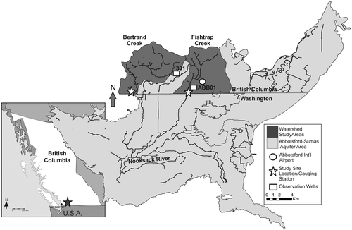
The purpose of this study is to compare different methods for estimating the relative contribution of groundwater to two groundwater-fed streams, Fishtrap and Bertrand Creeks, which drain the Abbotsford–Sumas aquifer in the Lower Fraser Valley of southwest British Columbia (BC) (Figure ). Previous studies have suggested the groundwater contribution in Fishtrap Creek is greater than in Bertrand Creek (Johanson Citation1988; Pearson Citation2004; Berg and Allen Citation2007), but to date, no comprehensive studies have been undertaken to compare the groundwater influxes into each stream. These particular streams were selected because, while the climate and topographic relief are the same, and the watersheds are of similar size, the geological substrate differs, with coarser grained surficial geology in the Fishtrap Creek watershed. Therefore, one hypothesis for the higher groundwater contribution to Fishtrap Creek is the more permeable geological substrate.
Figure 1. The Bertrand and Fishtrap Creek study sites in British Columbia (Canada). The study sites are located within the Canadian portion of the watersheds (dark grey).
This paper employs a simplified heat budget approach in combination with direct and indirect measurements of groundwater flux to compare the relative groundwater contributions along two reaches, one in Fishtrap Creek and one in Bertrand Creek. Field data were collected over five summer periods (July through September). In addition, high-quality data sets are available (streamflow, climate and groundwater data) to support the analysis. The paper also explores some of the challenges and uncertainties in making measurements in streams with low flows.
The study area
Surficial geology and land use
The surficial geology of the study area comprises Quaternary glacial sediments overlying Tertiary bedrock (Scibek and Allen Citation2005). The dominant units in the vicinity of the study area are the Fort Langley Formation and the Sumas Drift, and lesser amounts of Salish Sediments (Figure ). The Fort Langley Formation is a glaciomarine unit, comprising pebbly silt in clay, which has been interpreted as a confining layer (Mitchell et al. Citation2003). Sumas Drift comprises glaciofluvial sands and gravels, with discontinuous lenses of till and sandy till. The sand and gravel of the Sumas Drift are the sediments that host the Abbotsford–Sumas aquifer (~160 km2 in area). Salish Sediments occur in isolated locations in the study area, and comprise fluvial, lacustrine and colluvial sediments (Johanson Citation1988; Scibek and Allen Citation2005).
Figure 2. Generalized surficial geology of the Fishtrap Creek and Bertrand Creek watersheds.
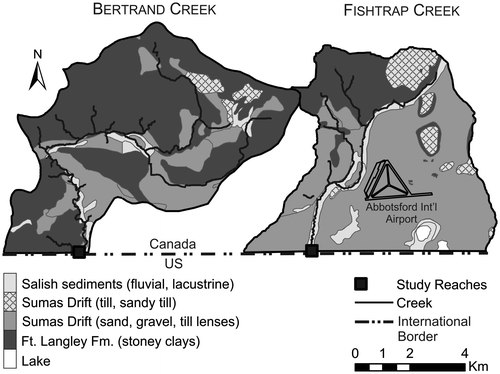
Fishtrap Creek watershed is approximately 37 km2, and Bertrand Creek watershed is approximately 51 km2 (Pruneda Citation2007). Within each watershed there are differences in the surficial geology (Figure ) and land use. Fishtrap Creek flows over predominantly Salish Sediments and Sumas Drift, with lesser amounts of the fine-grained Ft. Langley Formation in the upper reaches (Johanson Citation1988; Scibek and Allen Citation2005). Fishtrap Creek bed material at the study site is dominantly sand and fines, with trace to minor amounts of gravel, and abundant organic material (leaf litter and small woody debris). Fishtrap Creek watershed has agricultural use, dominantly blueberry fields, in the lower watershed, with some industrial and urban land in the upper reaches. Riparian shade is limited to seasonal invasive reed grasses present within the channel as in-stream vegetation, which becomes thicker throughout the summer season.
In contrast, the surficial sediments in the Bertrand Creek watershed are dominantly Ft. Langley Formation, with lesser amounts of Sumas Drift and Salish sediments near the stream channel (Johanson Citation1988; Scibek and Allen Citation2005). Near the study site on Bertrand Creek, the surficial material has intermittent sections of both coarse and fine-grained material. The bed material is dominated by well-sorted fine gravel and coarse sand, and the thickness of the bed material ranges between 0 and 30 cm, overlying clayey silt. Bertrand Creek flows through mixed development, dominantly rural residential in the study area, with some industrial and urban development in the upper reaches, and, at the study site, land use and cover is rural residential with some partial riparian cover from shrubs and deciduous tree canopy along the channel margins.
Climate and hydrology
The climate of the Abbotsford area is characterized as humid and temperate. Mean daily temperature at the Abbotsford International Airport (Station 1100030) ranges from 2.6°C in January to 17.7°C in August, with an annual mean of 10°C (Environment Canada Citation2014). The daily maximum temperature reaches close to 24°C in July and August. Annual average precipitation is 1573 mm/yr, with approximately 70% occurring between October and May, and only 64 cm falling as snow (Berka et al. Citation2001; Zebarth et al. Citation1998; Environment Canada Citation2014).
Fishtrap and Bertrand Creeks originate in the Abbotsford uplands and flow in a southerly direction to the Nooksack River in Washington, USA (Figure ). Both streams have flow regimes that are controlled by precipitation and interaction with groundwater (Berg and Allen Citation2007). The flow regime is driven by direct precipitation, and stream discharge lags precipitation by a few days, with minimum flows occurring in August, shortly after the minimum precipitation in July and August (Berg and Allen Citation2007). The streams provide habitat for salmon and two fish species listed as endangered in Canada, the Nooksack Dace and the Salish Sucker (Pearson Citation2004), and summer low flows have threatened fish populations through loss of habitat, increased predation and decreased water quality (Avery-Gomm et al. Citation2014). These streams have been identified as having potentially variable interaction with groundwater both between them and along their lengths (Johanson Citation1988; Starzyk Citation2012).
Groundwater recharge to the Abbotsford–Sumas Aquifer is primarily by rainfall, and groundwater levels fluctuate seasonally and inter-annually (Graham et al. Citation2014). Groundwater flow in the aquifer is generally southwest, but is controlled locally by differences in topography, geology and interactions with surface water. Groundwater levels generally lag precipitation by approximately 3 months and the annual variation in water levels is approximately 2 m (Scibek and Allen Citation2005). The variability of interaction with groundwater in the vicinity of the streams (Johanson Citation1988) is thought to be related to differences in surficial geologic units underlying the streams.
Methodology
Climate and hydrology
The nearest climate station to Fishtrap Creek is located at the Abbotsford International Airport, approximately 3.6 km away from the site (Figure ). Air temperature from this station was used to represent Fishtrap Creek. The stream gauging station on Bertrand Creek, operated by the United States Geological Survey (USGS) (Figure ) also records air temperature (and water temperature) using a Design Analysis® H-377 temperature sensor with an accuracy of ± 0.2°C. Air temperature from this station was used in this study to represent Bertrand Creek. Precipitation for both sites was based on that measured at the Abbotsford Airport. Based on regional precipitation patterns, the annual precipitation at Bertrand Creek is estimated to be within 100 mm/year of the amounts recorded at the Abbotsford Airport, which is only ~11 km away (Scibek and Allen Citation2005).
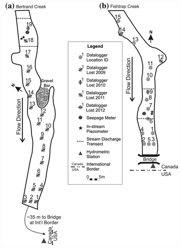
Figure 3. (a) The distribution of instrumentation at the Bertrand Creek study site. The United States Geological Survey (USGS) gauging station is located adjacent to the international border approximately 35 m downstream of the study reach. (b) The distribution of instrumentation at the Fishtrap Creek study site. The Water Survey of Canada (WSC) gauging station is located adjacent to the international border at the downstream end of the study reach.
For Fishtrap Creek, continuous stream discharge data were obtained at 15-minute intervals from the nearby Water Survey of Canada (WSC) gauging station (Station 08MH153) (Figure ). For Bertrand Creek, continuous stream discharge data were obtained at 15-minute intervals from the USGS gauging station (Station 12212390) located approximately 35 m downstream of the lower end of the study site (Figure ).
Near Fishtrap Creek, hourly groundwater levels were recorded at Environment Canada’s monitoring well ABB01, located approximately 660 m from the Fishtrap Creek study site (Figure ). Hourly groundwater level data for Bertrand Creek were obtained from the BC Ministry of Environment’s observation well #301, which is located 7 km northeast of the study site. Hourly groundwater temperatures were only available from ABB01. The temperature was recorded 8 m below ground surface (m bgs).
Interface temperature
The interface temperatures in this study are defined as water temperatures recorded at the surface of the streambed, using temperature loggers affixed at the water–bed interface. In July 2008, 15 temperature dataloggers were installed along a 40-m-long reach of Fishtrap Creek, and 19 temperature loggers were installed along a 70-m-long reach in Bertrand Creek (Figure ). Interface temperatures were recorded by TidbiT® v. 2 Temp loggers (UTBI-001) secured, unshielded, at the water–sediment interface. The loggers have an accuracy of ± 0.2°C and a resolution of 0.02°C. The loggers were factory calibrated, and calibration was verified prior to deployment in 2008 and upon retrieval of the loggers. The instrument drift was within the maximum specified by the manufacturer, and a linear drift correction was applied over the period of deployment.
At the downstream end of both sites, dataloggers were distributed in two transects, perpendicular to the channel, to monitor a cross-section of the streambed (Figure ). The remaining dataloggers were installed longitudinally along the channel bed at approximately evenly distributed spacing, in order to capture differences along the flow direction. Temperature was recorded hourly for the period of July 2008 to October 2012 in Fishtrap Creek, and from July 2008 to October 2011 in Bertrand Creek. In Bertrand Creek, the number of dataloggers decreased from 19 in 2008 and 2009 to three in 2010, and two in 2011, due to equipment loss (Figure ). Note that for 2012, logger data were not available and, therefore, water temperature data from the USGS gauging station were used.
Heat budget
The purpose of the simplified heat budgets calculated in this study is to examine the dominant potential drivers of the stream temperature at a broad scale. The heat budgets for Fishtrap and Bertrand Creeks were estimated using mean daily interface temperatures measured across the site, and daily climate data from the Abbotsford Airport. Surface heat budgets were calculated at a daily time step for the water–air interface to identify climatic factors influencing the stream temperature, and to indirectly isolate differences in the heat budget that may originate at the water–bed interface. The simplified heat budget was calculated based on the methods described in Sinokrot and Stefan (Citation1993) and Xin and Kinouchi (Citation2013). The total heat budget (HT) is represented by the heat exchange at the air–water interface (HA) and at the water–bed interface (HB) (Sinokrot and Stefan Citation1993):(1)
If all the heat exchanges occur at the air–water interface, then HT = HA. Any differences can be accounted for by exchanges at the water–bed interface (HB). Without instrumentation at each interface, this simplified approach can be used to identify broad patterns and differences with the heat budgets.
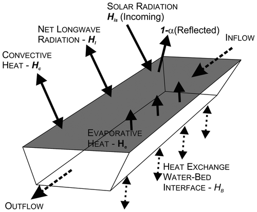
The main components in the net heat exchange at the air–water interface (HA) (Figure ), following Sinokrot and Stefan (Citation1993), Evans et al. (Citation1998), and Xin and Kinouchi (Citation2013), are: (2)
Figure 4. A schematic of the total heat budget (HT), with heat exchange across the water–air interface (HA) acting across the grey surface representing the top of the stream flow. The heat exchange across the water–bed interface is HB.
where His is the incident solar radiation at the water surface and α is the albedo of the water surface (0.06). Incident solar radiation was estimated using the solar position and radiation calculator available from the State of Washington Department of Ecology (Citation2014). The Bird Clear Sky model for direct radiation incident upon a horizontal surface was used, which is based on the latitude and elevation of each site (Bird and Hulstrom Citation1981). The albedo (α) in Equation (2) follows the work by Xin and Kinouchi (Citation2013), in which they applied an albedo of the water surface of 0.06. As Fishtrap Creek has limited vegetated canopy shading, and Bertrand Creek has intermittent deciduous riparian shading, an intermediate albedo value of 0.06 for water bodies between 0 and 60° latitude, and for a leafy deciduous canopy, was used (Ankstrom Citation1925; Henderson-Sellers and Wilson Citation1983; Betts and Ball Citation1997). Despite the differences in vegetation at both sites, the surface heat budget did not include a shade factor as no data were available to quantify the seasonal differences. This is a limitation of the approach that could be explored if more quantitative vegetation data were available.
The net longwave radiation (Hl) is given by Sinokrot and Stefan (Citation1993):(3)
where Ts is the mean daily stream temperature (degrees Kelvin) measured by the temperature loggers across each site, Ta is the mean daily air temperature (degrees Kelvin), εw and εa are the emissivities of the water surface (0.97) and atmosphere (Equation 4), respectively, and σ is the Stefan–Bolzmann constant (4.9 × 10¹⁵ TJ/m2/day/K4) (Xin and Kinouchi Citation2013): (4)
The net longwave radiation was calculated as a lumped parameter because data for the fraction of sunshine hours and cloud cover ratio were not available.
The evaporative heat flux (He) is calculated by Equation (5) (Sinokrot and Stefan Citation1993; Xin and Kinouchi Citation2013):(5)
where ρw is the density of water (kg/m3) determined from the mean stream temperature from Martin and McCutcheon (Citation1998) in Equation (6), and λ is the latent heat of vaporization of water (TJ/kg) given by Equation (7):(6)
(7)
where es is the saturated vapor pressure at the water surface temperature (hPa) (Equation 8), and ea is the vapor pressure of the air (hPa) (Equation 9), and are calculated following Allen et al. (Citation1998):(8)
(9)
In Equation (10), the term Wftn is the wind speed function for wind velocity at a height (z) above the water surface (m/s) (Gulliver and Stefan Citation1986; Sinokrot and Stefan Citation1993; Xin and Kinouchi Citation2013): (10)
The wind speed u2 from the climate station is converted to the wind speed at a height of 2 m (Equation 11) following the Food and Agriculture Organization of the United Nations (FAO) Penman–Monteith method (Allen et al. Citation1998): (11)
where uh is the wind speed measured at the climate station (m/s) at a height h, which for this study is 10 m.
The wind speed function calculation also relies on the calculation of the difference in the virtual temperature (ΔΘv), which is a function of air and water temperatures: (12)
where Pa is the atmospheric pressure recorded at the climate station.
The convective heat flux (Hc) is calculated following Sinokrot and Stefan (Citation1993) and Xin and Kinouchi (Citation2013): (13)
At the study sites, there are no tributaries contributing to the heat budget, and heat fluxes due to precipitation and biological and chemical fluxes are assumed to be negligible (Evans et al. Citation1998). Heat fluxes at the water–bed interface (HB) may comprise bed conduction, advection and fluid friction. In the absence of direct measurement of these individual parameters, these various heat flux components are lumped into a single water–bed interface heat flux component HB.
Air–water temperature relationship
Stream temperature responds to changing atmospheric conditions and solar radiation inputs. Air and water temperatures are influenced by solar radiation and therefore, in the absence of detailed climate data, air temperature is often used as a surrogate for solar radiation (Smith Citation1981; Mohseni and Stefan Citation1999; Johnson Citation2003). Due to thermal inertia, the temperature response at the bed interface is dampened and delayed relative to air temperature (Edinger et al. Citation1968; Sinokrot and Stefan Citation1993; Stefan and Preud'homme Citation1993; Bogan et al. Citation2003). To evaluate heat transfer from the air–water surface to the water–streambed interface, a response time calculation is required (Sinokrot and Stefan Citation1993; Stefan and Preud'homme Citation1993). The time constant, δ, for the stream temperature response follows Sinokrot and Stefan (Citation1993): (14)
where K is the net surface heat transfer coefficient (W/m2/°C) – a value of 30 was used based on Sinokrot and Stefan (Citation1993) – ρcp is the specific heat (kcal/m3/°C) and d is the mean water depth across the site (m). To apply to the daily mean temperatures, the time constant is rounded to the nearest whole day. In this study, the time constant was calculated using the mean depth of each stream over the five summers assuming a uniformly mixed water column. Using Equation (14), the time constant to relate the air temperature to the stream temperature was 30 hours for Fishtrap Creek, and 14 hours for Bertrand Creek. To facilitate calculations, the lag time for air temperature for both study sites was rounded to 1 day (24 hours).
Flux measurements
Groundwater flux into each stream was also measured. In an attempt to reduce uncertainty, three methods were used at each site: (1) one set of nested piezometers to measure the vertical hydraulic gradient, (2) a seepage meter to measure seepage flux across the channel bed and (3) stream gauging along two transects to measure stream discharge both upstream and downstream to estimate inputs of groundwater over a length of stream (Mellina et al. Citation2002; Moore et al. Citation2005; Rosenberry Citation2008). Field measurement locations for in-stream nested piezometers, seepage meters and stream discharge measurement transects are shown in Figure .
In-stream piezometers
The in-stream piezometer water level measurements provide an estimate of vertical hydraulic gradient between the deep and shallow piezometers. Shallow in-stream piezometers were installed as nested pairs in both Fishtrap and Bertrand Creeks. The piezometers were constructed of stainless steel with solid tips, and installed to depths of approximately 1.0 m and 0.5 m into the streambed adjacent to the channel bank. In the small streams, the position of the piezometers near the bank was considered appropriate to capture the vertical hydraulic gradient as well as provide some protection from high-flow events and vandalism. Measurements were made approximately every 30 minutes, with between six and 25 measurements per day. To estimate the flux, estimates of vertical hydraulic conductivity (Kz) of the surficial geology units at each study site were used (values from Scibek and Allen Citation2005). Kz for Sumas Drift in the vicinity of Fishtrap Creek is 0.56 m/day, and for the Ft. Langley Formation stony clays underlying Bertrand Creek, Kz is estimated as 0.20 m/day. Uncertainty in the piezometer readings is ± 0.035 m from the combined uncertainty in the installation depths and the individual measurements. The use of piezometers has the limitation that measurements are localized and represent the vertical flux at the point of the nested pair, and may not represent the sitewide conditions.
Seepage meters
Seepage meters can quantify fluid exchange across the sediment–water interface (Alexander and Caissie Citation2003; Kalbus et al. Citation2006; Essaid et al. Citation2008; Rosenberry Citation2008). The seepage meter consists of a bottomless cylinder set into the channel sediments and vented to a lightweight bag (Kalbus et al. Citation2006; Rosenberry Citation2008). The groundwater seeps into the surface water and enters the seepage meter, filling the bag, and the volume and rate of the water entering the bag are used to calculate the flux rate. The seepage meter in this study was modified for use in a flowing stream by giving it a low profile along the channel bed, and using a stilling box to protect the seepage collection bag from horizontal flow (Rosenberry Citation2008). Seepage meter measurements have limitations because the measurements are localized and represent point estimates of flux, while flux varies across the stream channel in space and time (Cey et al. Citation1998; Krause et al. Citation2007). Also the use of a seepage meter assumes that all flux into the meter is vertical, and that there is no component of hyporheic circulation entering the seepage meter. Despite this, the seepage meter has been used effectively in many studies to measure the flux, which normalizes the area covered by the meter, allowing the values recorded to be compared to other methods (Rosenberry and LaBaugh Citation2008).
The seepage meter was installed in approximately the same location in the stream in each of the three summer periods. Seepage measurement locations were selected to be representative of the channel section, and suitable for instrument installation. In Fishtrap Creek, the seepage meter was set approximately 8–10 cm into the fine-grained channel sediments; however; due to the low stream stage in Bertrand Creek, a lower profile seepage meter was used, and it was inserted into the sands and gravels of the streambed. Seepage was monitored for 2 to 3 days each summer in 2009, 2010 and 2011. Following an equilibration period of usually 24 hours after installation, the seepage flow into the collection bag was measured approximately every 30 minutes, with measurements repeated between eight and 24 times per day. Uncertainty in the seepage meter readings is ± 2.04 cm/day.
Stream discharge
Stream discharge transects can be used to estimate groundwater flux along the length of a channel by measuring the volume lost or gained over a distance. If there are no tributaries, or withdrawals along that length, then changes in stream discharge will be the result of groundwater fluxes. Stream discharge measurements were made using a Scientific Instruments 1250 Mini “pygmy” current meter. The pygmy meter is specially designed for use in small, shallow streams; the range of operation is approximately 0.03 to 1.5 m/s. The accuracy of the pygmy meter is given as generally 3.5%, but may approach 10% near the extent of its operating range, and therefore, for this study, 6.5% was used (Nelson et al. Citation2010). The streams were sampled using the 0.6 depth velocity-area method, in which the width, depth and velocity are measured across 10 vertical panels and used to calculate the stream discharge. The measurement uncertainty from the width and depth measurements for the area calculation across the section of channel is 0.05 m, which is added to the velocity uncertainty. The stream discharge was measured at upstream and downstream locations at each site, relative to the seepage meter, for comparison with the seepage volumes. Diurnal fluctuations in stream discharge and uncertainty in measurements under low-flow conditions potentially increase the uncertainty in the discharge measurements over the period of a day. Each velocity transect measurement was completed over approximately 30 minutes, and the velocity measurements were repeated a minimum of two times at both the upstream and downstream transects to obtain a mean value and to increase confidence in the readings (Berg and Allen Citation2007).
Results
Climate, stream discharge and groundwater level
Figure shows the mean daily precipitation (top panel), stream discharge (middle panel) and groundwater elevation (bottom panel) for the 5-year period (2008–2012). Annually, precipitation ranged from 1231.6 mm/year (2008) to 1536.1 mm/year (2012) with an average of 1422.5 ± 119.8 mm/year (Table ). Over the summers, the mean daily precipitation was 1.8 mm, with an average summer total of 168 mm, and a range of 63 mm (2013) to 252 mm (2010) (Table ).
Figure 5. The mean, maximum and minimum daily precipitation (top panel), stream discharge (middle panel), and groundwater elevation (bottom panel) over the 5-year period (2008–2012) for Fishtrap Creek (left column) and Bertrand Creek (right column).
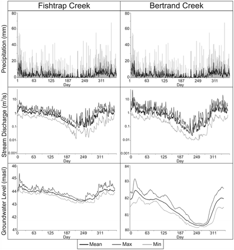
Table 1. Summary of mean daily data for Fishtrap and Bertrand Creeks for the five summer periods and annually (2008–2012). The summer and annual means for each parameter are shown with the standard deviations.
The mean annual stream discharge in Fishtrap Creek (0.9 ± 0.9 m3/s) was similar to the Bertrand Creek discharge (1.19 ± 2.2 m3/s) (Figure , middle panel) (Table ). Although the annual stream discharge patterns are similar, Fishtrap Creek has fewer extremes during both the high and low flow periods, as shown by the maximum and minimum values relative to the mean (Figure , middle panel). Bertrand Creek stream discharge is flashier; more high-flow events are observed outside the summer periods. During the summers, the mean daily stream discharge in Fishtrap Creek was 0.20 ± 0.3 m3/s, while in Bertrand Creek it was 0.1 ± 0.2 m3/s (Table ).
The mean annual groundwater elevation in ABB01 was 43.8 ± 0.4 m asl (above sea level) (ground surface elevation is 45.7 m asl), and 80.6 ± 0.3 m asl (ground surface elevation is 98.9 m asl) in Obs. Well #301 (Table ). During the summers, the groundwater elevation at ABB01 was 43.4 ± 0.2 m asl, and at Obs. Well #301 it was 80.6 ± 0.3 m asl (Table ). Overall, the groundwater levels mimic the stream discharge; however, there is a greater lag at Obs. Well #301 (Figure , bottom panel).
Stream–bed interface temperature
Figure shows the annual mean daily air temperature at Fishtrap (represented by the Abbotsford Airport) and at Bertrand Creek (represented by the USGS gauging station) (top panel). Over the five summers, the mean daily air temperature at Fishtrap Creek was 17.3 ± 2.9°C, while at Bertrand Creek it was 16.4 ± 2.7°C (Table ). Thus, air temperatures at Fishtrap are roughly 1°C higher, on average, compared to Bertrand Creek. The lower temperature at Bertrand Creek may be due to the stream setting where the sensor is located, which is characterized by more riparian vegetation and shading relative to the open field setting at the Abbotsford Airport and Fishtrap Creek.
Figure 6. The mean, maximum and minimum daily air temperature (top panel) and stream temperature (middle panel) over the 5-year period (2008–2012) for Fishtrap Creek (left column) and Bertrand Creek (right column). The groundwater temperatures (bottom panel) are shown only for ABB01.
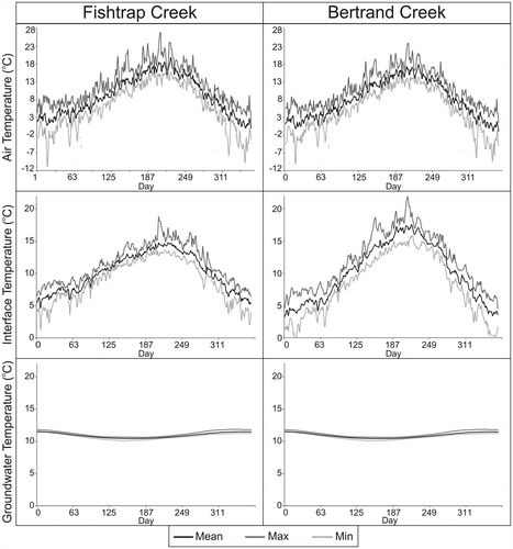
In Fishtrap Creek, the mean interface temperature over the five summer periods (Figure , middle panel) was 13.8 ± 1.3°C, while in Bertrand Creek it was 15.6 ± 1.8°C, a 1.8°C difference. It is noted that there was sub-reach scale variability in the interface temperatures at both sites. Here, the mean daily interface temperature across the site is discussed so as to allow a comparison between the two sites. The spatial (along the reach) and temporal (consecutive summer periods) variations in Fishtrap are explored elsewhere (Middleton et al., submitted). In addition to being lower, the interface temperatures in Fishtrap Creek have a smaller annual range than in Bertrand Creek (Figure , middle panel).
The annual mean daily groundwater temperature at ABB01 (representing both sites) is 10.9 ± 0.4°C (Table ). The mean annual groundwater temperature is close to the mean annual air temperature (10.2°C). Groundwater temperatures are also relatively constant inter-annually, as shown by the maximum and minimum curves in Figure . Over the five summers, the mean groundwater temperature was 10.7 ± 0.2°C.
Heat budget and regression analysis
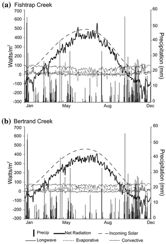
The simple daily surface heat budgets for Fishtrap and Bertrand Creeks were computed for the 5-year study period, and an example for 2009 is shown in Figure . The surface heat budget for both streams indicates that, annually, incoming solar radiation dominates the net radiation. At a daily time scale, evaporative heat flux events are noticeable. Precipitation events do not appear to be an important component, either during the event or during the absence of precipitation.
Figure 7. Daily surface heat budget and precipitation for 2009 for (a) Fishtrap Creek, and (b) Bertrand Creek.
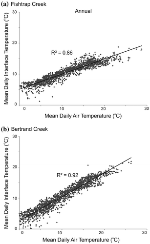
The surface heat budget indicates that solar radiation dominates the heat flux at the air–water interface; however, the interface temperature response to solar radiation is delayed and dampened relative to air temperature due to the thermal inertia of water (Sinokrot and Stefan Citation1993; Bogan et al. Citation2003). The linear relationship between the air temperature and the 1-day (24 hour) lagged interface temperature was used to determine the variance in interface temperature that is explained by air temperature. The linear relationship is plotted in Figure , for all days with non-negative temperatures over the 5-year period. The 1-day lagged air temperature explains more variance in interface temperature in Bertrand Creek (R2 = 0.92) than in Fishtrap Creek (R2 = 0.86). The intercept of the linear regression line is also higher for Fishtrap Creek (5.15°C) than for Bertrand Creek (2.70°C). The strength of the regression shows that that incoming solar radiation inputs dominate the heat exchanges in the stream, but indicates there are differences between the two streams annually.
Figure 8. Mean daily 1-day lagged air temperature and interface temperature for all non-negative air temperature days from 2008 to 2012 for (a) Fishtrap Creek, and (b) Bertrand Creek.
Using observations from the summer periods only (Figure ), the slope of the regression lines for both streams is lower than for the annual data, indicating that the interface temperatures increase at a lower rate relative to air temperature during the summer. The conductive heat flux across the streambed depends on the amplitude of the daily water temperature cycle, and because the amplitude is greater during the summer, streambed conductance would be more prominent, leading to a lower regression slope. However, the magnitude of the decrease in the regression slope during the summer as compared to annually was not the same for each stream. Langan et al. (Citation2001) showed that the relationship between air and water temperatures is strongest during the summer when radiation inputs are highest and low-flow occurrences are most common. From the regression relationship, the 1-day lagged air temperature explains only 31% of the variance in interface temperature in Fishtrap Creek, while in Bertrand Creek it explains 76% of the variance. In Fishtrap Creek, factors other than air temperature are contributing to the remaining 69% of the variance in the summer interface temperatures. At temperatures above 20°C, evaporative cooling can alter the linear relationship between air and water temperature (Mohseni and Stefan Citation1999; Kelleher et al. Citation2012). However, evaporative cooling is not considered significant as stream temperatures during the summer generally remain below 20°C. Furthermore, the surface heat budget indicates that the evaporative heat flux remains relatively constant over the summer (Figure ).
Figure 9. Mean daily 1-day lagged air temperature and interface temperature for the summer periods (July through September) from 2008 to 2012 for (a) Fishtrap Creek, and (b) Bertrand Creek.
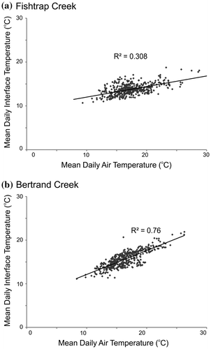
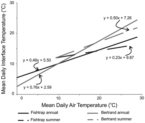
Figure compares the interface and air temperature for both sites, for both the annual and summer periods. The slope and intercept of the linear regression have been shown to be related to the interaction between streams and the groundwater inputs (Caissie Citation2006). Caissie (Citation2006) reports that streams not dominated by groundwater inputs generally have steeper slopes than groundwater-dominated streams, and comparisons of the regression lines for different streams can be indicative of relative contributions from groundwater. The regression line for Fishtrap Creek has a lower slope and higher intercept than Bertrand Creek, for both the annual data and the summer period (Figure ). The slopes for both streams for the summer periods decrease during the summer, indicating that interface temperatures in the summer are moderated relative to air temperature. The comparison in Figure clearly shows that this moderating influence is stronger in Fishtrap Creek during both comparison periods.
Figure 10. Comparison of the linear regressions for Fishtrap Creek and Bertrand Creek for all non-negative temperature days (solid lines), and for summer period data only (dashed lines).
Flux measurements
The hydraulic gradients measured in the in-stream piezometers at both sites varied during the day, between consecutive days, and between the summer periods. Table reports the vertical hydraulic gradients and the calculated flux, both as mean daily values. A positive value for the flux (negative hydraulic gradient) indicates an upward flow. In Fishtrap Creek, daily flux was positive for all but 2 days, and on these 2 days the hydraulic gradients were very low. Over the 5 years, the average flux measured by the piezometers in Fishtrap was 11.4 ± 9.5 cm/day. In Bertrand Creek, the hydraulic gradients were very low and the flux direction variable; therefore, the results at this site are highly uncertain. The average flux over the 5 years was –0.12 ± 0.88 cm/day.
Table 2. Summary of mean daily field data from the seepage meters, in-stream piezometers and discharge transects collected at Fishtrap and Bertrand Creeks for the five summer periods (2008–2012). The number of measurements is shown in parentheses beside each daily value.
Seepage measured with the seepage meters similarly fluctuated throughout the day, between consecutive days, and between the summer periods at both sites. The final values reported in Table are the mean daily seepage flux; the reported values include a resistance correction factor of 1.05, following Rosenberry and LaBaugh (Citation2008). The resistance correction factor is applied to compensate for resistance to flow within the meter and frictional flow losses that lead to underestimation of the flux rate. The seepage values for both streams are positive, which indicates an upward flux of groundwater into the stream. In Fishtrap Creek, the mean daily upward flux over the 5-year period was 23.5 ± 13.6 cm/day, and this seepage rate is of the same order of magnitude as the flux measured by the piezometers. In Bertrand Creek, the seepage flux was 25.3 ± 5.3 cm/day.
The seepage increased in Fishtrap Creek over the summer measurement period in both 2009 and 2010. In Bertrand Creek, the seepage was more variable, with a decrease in seepage over the period of measurement in 2009 and 2010, and an increase in 2011. However, with a maximum of only 3 sampling days per summer, it is not known if these trends are significant.
The stream discharge transects at both Fishtrap and Bertrand Creeks showed small volume decreases per length of stream, but all the values are within the range of uncertainty (Table ) so it is unclear whether there is indeed a reach-scale loss of stream water, which would be inconsistent with the flux and seepage measurements. As a result, the volume lost or gained between the stream discharge transects could not be determined with any confidence.
Discussion
Overall, the annual mean daily stream discharge and stream temperature at Fishtrap Creek are similar to those at Bertrand Creek; however, the main differences occur at the extremes. Bertrand Creek discharge and temperatures have a larger annual range between the peaks and the lows. The stream temperatures in Fishtrap Creek are attenuated relative to the air temperature, and the minimum temperatures remain closer to the mean temperatures than in Bertrand Creek.
The surface heat budgets for the two streams (Figure ) show that Fishtrap Creek has higher net radiation than Bertrand Creek throughout the year, peaking during the summer, and more variability over the annual period. This is a reflection of the different air and stream temperature data sets for each site, which are used to calculate the evaporative, convective and longwave radiation fluxes. Although the net radiation is higher and more variable in Fishtrap Creek relative to Bertrand Creek, during the summer periods stream temperatures in Fishtrap Creek are lower (Figure ) and are less variable than in Bertrand Creek. This suggests that there is a heat sink in Fishtrap Creek that cannot be accounted for in the heat budget at the air–water interface. The cooler summer interface temperatures and higher stream discharge in Fishtrap Creek (Figures and ) relative to Bertrand Creek suggest a greater contribution of groundwater to the summer stream flow in Fishtrap Creek. The comparison of the linear regression of the 1-day lagged air temperature and stream temperature (Figure ) indicates that Fishtrap Creek receives greater groundwater contribution throughout the year relative to Bertrand Creek, and that the relative proportion of groundwater to the stream flow increases during the summer periods. The influx of groundwater at a relatively constant temperature, near 11°C over the summer, acts to attenuate interface temperature variations and moderates water temperature fluctuations relative to changing atmospheric conditions.
The field measurement data from seepage meters and in-stream piezometers loosely support the surface heat budget and interface temperature measurements. In Fishtrap Creek, the seepage meter and piezometers both indicated an upward flux of water into the stream, and the results are of the same order of magnitude over the 5-year period: 11 and 23 cm/day, respectively. In Bertrand Creek, the hydraulic gradient was very low. This, in combination with the presence of lower Kz material around Bertrand Creek, leads to a very low vertical groundwater flux compared to Fishtrap Creek. The seepage meter and piezometer results at Bertrand Creek differed by an order of magnitude: –0.12 cm/day and 25 cm/day, respectively. The higher seepage values can be explained by the placement of the low-profile seepage meter. The seepage measured by the seepage meter was potentially from circulating hyporheic flows in the sands and gravels, or perhaps from leakage through the sands and gravels into the seepage meter. Therefore, it is likely that the seepage rates are overestimated for Bertrand Creek. Unfortunately, the stream discharge measurements at both sites could not be used due to measurement difficulties at low flows. In Fishtrap Creek, slow stream velocity and in-stream vegetation impeded measurements, and at Bertrand Creek, shallow water depth and slow velocity were factors impeding accurate stream discharge measurements. These factors have been shown to increase the level of uncertainty and variability in stream discharge measurements over similar stream lengths (Berg and Allen Citation2007).
Considering the heat balance results, the interface temperatures, and the in-stream measurements at both sites, groundwater flux into Fishtrap Creek is higher than at Bertrand Creek. The main difference between these two sites is the surficial geology. The lower reaches of Fishtrap Creek are in the higher permeability coarse sands of the Sumas Drift, while the lower reaches of Bertrand Creek are in the predominantly fine-grained Ft. Langley Formation. Topographically, the streams reaches are similar, but a much lower vertical hydraulic gradient was measured in Bertrand Creek compared to Fishtrap Creek, suggesting that there is limited potential for vertical movement of groundwater into the stream at Bertrand Creek. Combined with the low vertical Kz at Bertrand Creek, the overall groundwater flux is much reduced. Starzyk (Citation2012) found negligible change in stream discharge in the same reach of Bertrand Creek, and attributed this to a large component of groundwater flowing horizontally under this portion of the stream due to topographic controls. Starzyk (Citation2012) also concluded that in the absence of strongly upwelling groundwater, hyporheic flow creates local-scale circulation along the streambed. This suggests that regional groundwater flow patterns may play an important role in determining local exchanges between groundwater and surface water. Future work should focus on incorporating knowledge of the regional groundwater flow in order to assess the local connectivity between groundwater and surface water.
Conclusions
In many streams, the relative proportion of groundwater contributing to stream flow is generally highest during the summer low flow period, and groundwater sustains the flow. Groundwater also has a fairly stable temperature year-round, so it can buffer the effects of summer heating on stream temperatures. For these reasons, it is important to understand controls on groundwater influxes to streams, particularly during the summer when critical thresholds for streamflow and stream temperature may be reached. However, data on groundwater–surface water interactions are often sparse, and application of field methods can be challenging during periods of low flow. This study used a variety of methods to evaluate the relative contributions of groundwater to two groundwater-fed streams.
While a simplified surface heat budget was used due to a lack of detailed energy flux data, it was useful for understanding heat exchanges at the field sites. Specifically, the surface heat budget indicates that, annually, incoming solar radiation dominates the net radiation. At a daily time scale, evaporative heat flux events are noticeable, but precipitation events do not appear to be an important component, either during the event or during the absence of precipitation. A regression analysis between interface temperature and air temperature showed that incoming solar radiation inputs dominate the heat exchanges in the stream, but indicated there are differences between the two streams annually and during the summer. The strength of the regression in Fishtrap Creek is particularly poor in the summer, when factors other than air temperature contribute 69% of the variance in the summer interface temperatures. These results suggest that there is a heat sink at the interface in Fishtrap Creek, which is interpreted as a groundwater influx.
In-stream piezometers, supported by seepage meter measurements, were most effective at Fishtrap Creek for evaluating the groundwater influx. At Bertrand Creek, the combined effect of a low vertical hydraulic gradient and possible interference of hyporheic flow with the seepage meters led to inconclusive flux measurements. Manual stream discharge measurements down the stream reaches were found to be inconclusive due to the magnitude of uncertainty in the stream discharge during the low flow measurements.
What is particularly interesting is that while the two streams share similar climate and topography, the geological substrate is different. The more permeable substrate surrounding Fishtrap Creek, in combination with a steeper vertical gradient, results in a greater groundwater influx. This greater influx will act to sustain streamflow and buffer increased stream temperatures associated with low summer flows.
Acknowledgements
This research was supported by the Natural Sciences and Engineering Research Council (NSERC) through a Discovery Grant to Diana Allen, as well as research grants from Simon Fraser University’s Community Trust Endowment Fund (CTEF), Watershed Watch Salmon Society and the Pacific Institute for Climate Solutions. The authors would like to thank Environment Canada and the BC Ministry of Environment for groundwater temperature and level data, and the United States Geological Survey and Water Survey of Canada for stream gauging data. The authors are grateful to three anonymous reviewers for their helpful suggestions for improving this manuscript.
References
- Alexander, M., and D. Caissie. 2003. Variability and comparison of hyporheic water temperatures and seepage fluxes in a small Atlantic salmon stream. Ground Water 41(1): 72–82.
- Allen, R. G., L. S. Pereira, D. Raes, and M. Smith. 1998. Crop evapotranspiration: Guidelines for computing crop water requirements. FAO Irrigation and Drainage Paper 56. Rome: Food and Agriculture Organization of the United Nations.
- Anderson, M. 2005. Heat as a ground water tracer. Ground Water 43(6): 951–968.
- Ankstrom, A. 1925. The albedo of various surfaces of ground. Geografiska Annaler 7: 323–342.
- Arrigoni, A., G. Poole, L. Mertes, S. O'Daniel, W. Woessner, and S. Thomas. 2008. Buffered, lagged, or cooled? Disentangling hyporheic influences on temperature cycles in stream channels. Water Resources Research 44(9): W09418. doi:10.1029/2007WR006480.
- Avery-Gomm, S., J. S. Rosenfeld, J. S. Richardson, and M. Pearson. 2014. Hydrological drought and the role of refugia in an endangered riffle-dwelling fish, Nooksack dace (Rhinichthys cataractae spp.). Canadian Journal of Fisheries and Aquatic Science 77: 1625–1634. doi:10.1139/cjfas-2013-0585.
- Baxter, C., F. R. Hauer, and W. Woessner. 2003. Measuring groundwater–stream water exchange: New techniques for installing minipiezometers and estimating hydraulic conductivity. Transactions of the American Fisheries Society 132(3): 493–502.
- Beatty, S. J., D. L. Morgan, F. J. McAleer, and A. R. Ramsay. 2010. Groundwater contribution to baseflow maintains habitat connectivity for Tandanus bostocki (Teleostei: Plotosidae) in a south-western Australian river. Ecology of Freshwater Fish 19: 595–608. doi:10.1111/j.1600-0633.2010.00440.x.
- Becker, M. W., T. Georgian, H. Ambrose, J. Siniscalchi, and K. Fredrick. 2004. Estimating flow and flux of ground water discharge using water temperature and velocity. Journal of Hydrology 296(1–4): 221–233.
- Berg, M. A., and D. M. Allen. 2007. Low flow variability in groundwater-fed streams. Canadian Water Resources Journal 32(3): 227–245.
- Berka, C., H. Scheier, and K. Hall. 2001. Linking water quality with agricultural intensification in a rural watershed. Water, Air, and Soil Pollution 127: 389–401.
- Betts, A. K., and J. H. Ball. 1997. Albedo over the boreal forest. Journal of Geophysical Research 102(D24): 28,901–28,909.
- Bird, R. E., and R. L. Hulstrom. 1981. Simplified clear sky model for direct and diffuse insolation on horizontal surfaces. Technical Report No. SERI/TR 642-761. Golden, CO: Solar Energy Research Institute.
- Bogan, T., O. Mohseni, and H. G. Stefan. 2003. Stream temperature–equilibrium temperature relationship. Water Resources Research 39(9): 1245–1257.
- Boulton, A. 1993. Stream ecology and surface-hyporheic hydrologic exchange: Implications, techniques and limitations. Australian Journal of Marine and Freshwater Research 44(4): 553–564.
- Brewer, S. K. 2013. Groundwater influences on the distribution and abundance of riverine smallmouth bass, Micropterus Dolomieu, in pasture landscapes of the Midwestern USA. River Research and Applications 29: 269–278.
- Burn, D. H., J. M. Buttle, D. Caissie, G. MacCulloch, C. Spence, and K. Stahl. 2008. The processes, patterns and impacts of low flows across Canada. Canadian Water Resources Journal 33(2): 107–124.
- Caissie, D. 2006. The thermal regime of rivers: A review. Freshwater Biology 51(8): 1389–1406.
- Caissie, D., B. L. Kurylyk, A. St-Hilaire, N. El-Jabi, and K. T. B. MacQuarrie. 2014. Streambed temperature dynamics and corresponding heat fluxes in small streams experiencing seasonal ice cover. Journal of Hydrology 519: 1441–1452.
- Cey, E. E., D. L. Rudolph, G. W. Parkin, and R. Aravena. 1998. Quantifying groundwater discharge to a small perennial stream in southern Ontario, Canada. Journal of Hydrology 210(1–4): 21–37.
- Conant, B. 2004. Delineating and quantifying ground water discharge zones using streambed temperatures. Ground Water 42(2): 243–257.
- Constantz, J. 2008. Heat as a tracer to determine streambed water exchanges. Water Resources Research 44: W00D10.
- Cunjak, R. A., T. Linnansaari, and D. Caissie. 2013. The complex interaction of ecology and hydrology in a small catchment: A salmon's perspective. Hydrological Processes 27: 741–749.
- Edinger, J. E., D. W. Duttweiler, and J. C. Geyer. 1968. The response of water temperature to meteorological conditions. Water Resources Research 4(5): 1137–1143.
- Environment Canada. 2014. Historical climate data, 2014. http://climate.weather.gc.ca/ (accessed October, 2014).
- Essaid, H. I., C. M. Zamora, K. A. McCarthy, J. R. Vogel, and J. T. Wilson. 2008. Using heat to characterize streambed water flux variability in four stream reaches. Journal of Environmental Quality 37 (3): 1010–1023.
- Evans, E. C., G. R. McGregor, and G. E. Petts. 1998. River energy budgets with special reference to river bed processes. Hydrological Processes 12: 575–595.
- Fleckenstein, J., M. Anderson, G. Fogg, and J. Mount. 2004. Managing surface water–groundwater to restore Fall flows in the Cosumnes River. Journal of Water Resources Planning and Management 1304(4): 301–310.
- Graham, G., D. M. Allen, and B. Finkbeiner. 2014. Climate controls on nitrate concentration variability in an unconfined aquifer in the lower Fraser River valley, British Columbia. Environmental Earth Sciences Journal 73: 2895–2907.
- Gulliver, J. S., and H. G. Stefan. 1986. Wind function for a sheltered stream. Journal of Environmental Engineering–ASCE 112(2): 387–399.
- Hannah, D. M., I. A. Malcolm, C. Soulsby, and A. F. Youngson. 2004. Heat exchanges and temperatures within a salmon spawning stream in the Cairnorms, Scotland: Seasonal and sub-seasonal dynamics. River Research and Applications 20: 635–652.
- Hatch, C. E., A. T. Fisher, J. S. Revenaugh, J. Constantz, and C. Ruehl. 2006. Quantifying surface water–groundwater interactions using time series analysis of streambed thermal records: Method development. Water Resources Research 42: W10410. doi:10.1029/2005WR004787.
- Hayashi, M., and D. O. Rosenberry. 2002. Effects of ground water exchange on the hydrology and ecology of surface water. Ground Water 40: 309–316.
- Hebert, C., D. Caissie, M. G. Mysore, and N. El-Jabi. 2011. Study of stream temperature dynamics and corresponding heat fluxes within Miramichi River catchments (New Brunswick, Canada). Hydrological Processes 25: 2439–2455. doi:10.1002/hyp.8021.
- Henderson-Sellers, A., and M. F. Wilson. 1983. Surface albedo data for climatic modeling. Reviews of Geophysics 21(8): 1743–1778.
- Johanson, D. 1988. Fishtrap/Pepin/Bertrand Creeks watershed management basin plan. groundwater component. Province of British Columbia Ministry of Environment and Parks, Water Management Branch. Surrey, BC.
- Johnson, S. L. 2003. Stream temperature: Scaling of observations and issues for modelling. Hydrological Processes 17: 497–499. doi:10.1002/hyp.5091.
- Johnson, S. L., and J. A. Jones. 2000. Stream temperature responses to forest harvest and debris flows in western Cascades, Oregon. Canadian Journal of Fisheries and Aquatic Sciences 57: 30–39.
- Jones, J. B., and P. J. Mulholland ed. 2000. Streams and ground waters. San Diego, CA: Academic Press.
- Kalbus, E., F. Reinstorf, and M. Schirmer. 2006. Measuring methods for groundwater–surface water interactions: A review. Hydrology and Earth System Sciences 10(6): 873–887.
- Kanno, Y., J. C. Vokoun, and B. H. Letcher. 2014. Paired stream–air temperature measurements reveal fine-scale thermal heterogeneity within headwater brook trout stream networks. River Research and Applications 30(6): 745–755.
- Kelleher, C., T. Wagener, M. Gooseff, B. McGlynn, K. McGuire, and L. Marshall. 2012. Investigating controls on the thermal sensitivity of Pennsylvania streams. Hydrologic Processes 26: 771–785.
- Krause, S., A. Bronstert, and E. Zehe. 2007. Groundwater–surface water interactions in a north German lowland floodplain – Implications for the river discharge dynamics and riparian water balance. Journal of Hydrology 347(3–4): 404–417.
- Kurylyk, B. L., K. T. B. MacQuarrie, T. Linnansaari, R. A. Cunjak, and R. A. Curry. 2014. Preserving, augmenting, and creating cold-water thermal refugia in rivers: Concepts derived from research on the Miramichi River. New Brunswick (Canada). Ecohydrology. doi:10.1002/eco.1566.
- Langan, S. J., L. Johnston, M. J. Donaghy, A. F. Youngson, D. W. Hay, and C. Soulsby. 2001. Variation in river water temperatures in an upland stream over a 30-year period. The Science of the Total Environment 265: 195–207.
- Malcolm, I., C. Soulsby, A. Youngson, and D. Hannah. 2005. Catchment-scale controls on groundwater–surface water interactions in the hyporheic zone: Implications for salmon embryo survival. River Research and Applications 21(9): 977–989.
- Martin, J. L., and S. C. McCutcheon. 1998. Hydrodynamics and transport for water quality modeling. Boca Raton, FL: CRC Press.
- Meisner, J. D., J. S. Rosenfeld, and H. A. Regier. 1988. The role of groundwater in the impact of climate warming on stream salmonines. Fisheries 13(3): 2–8.
- Mellina, E., R. Moore, S. Hinch, J. Macdonald, and G. Pearson. 2002. Stream temperature responses to clearcut logging in British Columbia: The moderating influences of groundwater and headwater lakes. Canadian Journal of Fisheries and Aquatic Sciences 59(12): 1886–1900.
- Middleton, M. A., P. H. Whitfield, and D. M. Allen. Submitted. Independent component analysis of local-scale temporal variability in stream/bed interface temperature.
- Mitchell, R. J., R. S. Babcock, S. Gelinas, L. Nanus, and D. E. Stasner. 2003. Ground water quality: Nitrate distribution and source identification in the Abbotsford-Sumas aquifer, northwestern Washington State. Journal of Environmental Quality 32: 789–800.
- Mohseni, O., and H. G. Stefan. 1999. Stream temperature/air temperature relationship: A physical interpretation. Journal of Hydrology 218: 128–141.
- Moore, R. D., D. L. Spittlehouse, and A. Story. 2005. Riparian microclimate and stream temperature response to forest harvest: A review. Journal of the American Water Resources Association 41: 813–834.
- Nelitz, M. A., E. A. MacIsaac, and R. M. Peterman. 2007. A science-based approach for identifying temperature sensitive streams for Rainbow Trout. North American Journal of Fisheries Management 27(2): 405–424. doi:10.1577/M05-146.1.
- Nelson, P. A., W. E. Dietrich, and J. G. Venditti. 2010. Bed topography and the development of forced bed surface patches. Journal of Geophysical Research: Earth Surface (2003–2012) 115(F4). doi:10.1029/2010JF001747.
- Pearson, M. P. 2004. The ecology, status and recovery prospects of Nooksack Dace (Rhinichthys cataractae spp.) and Salish Sucker (Catostomus sp.) in Canada. PhD thesis, University of British Columbia, Resource Management and Environmental Studies, 239 pp.
- Power, G., R. S. Brown, and J. G. Imhof. 1999. Groundwater and fish – Insights from northern North America. Hydrological Processes 13(3): 401–422.
- Pruneda, E. B. 2007. Use of stream response functions and STELLA software to determine impacts of replacing surface water diversions with groundwater pumping withdrawals on in-stream flows within the Bertrand Creek and Fishtrap Creek watersheds, Washington State, USA. MSc thesis, Washington State University, Department of Civil and Environmental Engineering.
- Rosenberry, D. 2008. A seepage meter designed for use in flowing water. Journal of Hydrology 359(1–2): 118–130.
- Rosenberry, D., and J. W. LaBaugh. 2008. Field techniques for estimating water fluxes between surface water and ground water . US Geological Survey, Techniques and methods 4-D2. USGS. Reston, VA.
- Schmidt, C., M. Bayer-Raich, and M. Schirmer. 2006. Characterization of spatial heterogeneity of groundwater–stream water interactions using multiple depth streambed temperature measurements at the reach scale. Hydrogeology and Earth System Sciences 10(6): 849–859.
- Scibek, J., and D. M. Allen. 2005. Numerical groundwater flow model of the Abbotsford-Sumas aquifer, central Fraser Lowland of BC, Canada, and Washington State, US. Prepared for Environment Canada. Unpublished report prepared for Environment Canada. Burnaby, BC.
- Silliman, S. E., and D. F. Booth. 1993. Analysis of time-series measurements of sediment temperature for identification of gaining vs. losing portions of Juday Creek, Indiana. Journal of Hydrology 146(1–4): 131–148.
- Sinokrot, B. A., and H. G. Stefan. 1993. Stream temperature dynamics: Measurements and modelling. Water Resources Research 29(7): 2299–2312.
- Smakhtin, V. 2001. Low flow hydrology: A review. Journal of Hydrology 240(3–4): 147–186. doi:10.1016/S0022-1694(00)00340-1.
- Smith, K. 1981. The prediction of river water temperature. Hydrological Sciences Bulletin 26(1): 19–32.
- Starzyk, C. A. 2012. Simulating surface water–groundwater interaction in the Bertrand Creek watershed, B.C. PhD thesis, University of British Columbia, Department of Geological Engineering, 190 pp.
- State of Washington Department of Ecology. 2014. Solrad. v. 1.2: A solar position and radiation calculator for Microsoft Excel/VBA. State of Washington http://www.ecy.wa.gov/programs/eap/models.html (accessed April, 2014).
- Stefan, H. G., and E. B. Preud'homme. 1993. Stream temperature estimation from air temperature. Water Resources Bulletin 29(1): 27–45.
- Stonestrom, D. A., and J. Constantz, ed. 2003. Heat as a tool for studying the movement of groundwater near streams. US Geological Survey Circular 1260, 96 pp. USGS, Reston, VA.
- Webb, B. W., and Y. Zhang. 1997. Spatial and seasonal variability in the components of the river heat budget. Hydrological Processes 11: 79–101.
- Winter, T. C., J. W. Harvey, O. L. Franke, and W. M. Alley. 1998. Groundwater and surface water – A single resource. US Geological Survey Circular 1139. USGS. Denver, CO.
- Xin, Z., and T. Kinouchi. 2013. Analysis of stream temperature and heat budget in an urban river under strong anthropogenic influences. Journal of Hydrology 489: 16–25.
- Zebarth, B. J., B. Hii, H. Liebcher, K. Chipperfield, J. W. Paul, G. Grove, and S. Y. Szeto. 1998. Agricultural land use practices and nitrate contamination in the Abbotsford aquifer, British Columbia, Canada. Agriculture, Ecosystems and Environment 69: 99–112.
- Zhang, T. 2005. Influence of the seasonal snow cover on the ground thermal regime: An overview. Reviews of Geophysics 43(4): doi:10.1029/2004RG000157.