
Abstract
The 2014 Assiniboine River flood caused millions of dollars in damage to southern Manitoba and Saskatchewan. Heavy precipitation in late June and early July resulted in states of emergency being declared in both provinces as water levels reached record levels in the Upper Assiniboine Watershed, and near record levels downstream of the City of Brandon. In spite of the significant measures both provinces took to protect their citizens, the flood washed out roads and bridges and caused severe damage to properties, riverbanks and dikes. Some communities became isolated due to the flood damage to roads. Several hundred people were evacuated from homes and communities in Manitoba and Saskatchewan. The other major impact was on the farming community. The timing of this flood made it more costly than the 2011 flood from the farming perspective since most farmers had already planted their crops. The origin of the 2014 flood was different from any other major flood of the Assiniboine River since records have been kept; this was a true summer flood in that the spring freshet had already passed and flows had receded to a baseflow condition. The event was entirely due to rainfall on a basin where conditions were extremely wet and had been since before the 2011 flood. This resulted in record flows being recorded on many tributaries, and flows nearly equal to those of the 2011 event along the Assiniboine River. It should be noted that the 2011 event was initially a snowmelt event due to greater-than-normal accumulation of winter snowpack. The 2014 summer flood was “unprecedented” in the previous 130 years of observations of the Assiniboine River flows and follows only three years after the 2011 event that was described with the same adjective. The influence of anthropogenic activities, both in changing the land use and extending the drainage network, undoubtedly has played a significant role in altering prairie hydrology and potentially increasing the magnitude of flood events.
L’inondation en été de 2014, de la rivière Assiniboine et ses affluents a été sans précédent dans les 130 années d’observations préalables. Les précipitations fortes à la fin de juin et le début de juillet ont résulté dans des niveaux d’eau de record dans la région de la rivière Assiniboine supérieur, et proche à des niveaux de record dans la ville de Brandon au Manitoba. Des situations d’urgences en été décélérer en Manitoba et Saskatchewan. En dépit des mesures significatives que les deux provinces ont pris pour protéger leurs citoyens, l’inondation a délavées des rues et des ponts, a inondées des champs agricoles et a causer du dommage sévère a des propriétés, des berges et des digues. Même si l’inondation avait des pointes de débits semblables à l’inondation de record de la rivière Assiniboine de 2011, l’origine de l’inondation de 2014 était très diffèrent que toutes les autres inondations majeures dans la région de la rivière Assiniboine. C’était une véritable inondation d’été dans le fait que le ruissellement du printemps avait reculé a un débit de bas constant, et l’évènement a été complètement due à de la précipitation sur un bassin ou les conditions antécédentes étaient extrêmement détrempé. Dans des cas nombreux, il en est résulté dans des enregistrements de flux de record sur les affluents et des flux qui ont été proche a égalant l’évènement de 2011, le longue de l’axe principal de la rivière Assiniboine.
Geographical and hydrological setting
The geographical and hydrological setting of the Assiniboine River basin has been presented previously in this issue in the context of the 2011 flood (Blais et al. this issue). The primary cause of the 2014 flood event on the Assiniboine River and its tributaries was a series of significant rainfalls that occurred over southwest of Manitoba and southeast of Saskatchewan in early summer. The antecedent soil conditions in the Assiniboine River basin, which had been extremely wet since before the 2011 flood, may have exacerbated the 2014 flood impacts. Although extreme precipitation and wet antecedent conditions were the primary cause of the 2014 flood, human impacts on the basin were also a contributing factor. It is not possible to quantify the effect of land drainage on the 2014 flood at this time, but the event would not have been as severe without the existing land drainage network and increase in the effective drainage area. Pomeroy et al. (Citation2014) have shown that wetland drainage at the Smith Creek Basin in Saskatchewan has had a significant impact on snowmelt and rainfall runoff volumes. The area of wetland within the Smith Creek Basin has significantly decreased since 1958, when it was estimated at 96 km2 covering 24% of the basin area, to 2008 when it had an area of only 43 km2 covering 11% of the basin. These researchers have estimated that restoration of the Smith Creek wetlands back to the extent measured in 1958 would have decreased the simulated 2011 flood peak by 32%. The impact of wetland restoration on the 2014 event would be of similar magnitude.
Causes of the flood
The 2014 Spring Outlook predicted a minor to moderate risk of spring flooding on the Assiniboine River (Manitoba Infrastructure and Transportation [MIT] Hydrologic Forecast Centre Citation2014a, Citation2014b). The prediction was based on the observed normal to well above normal soil moisture in the upper portions of the watershed, and snow-water equivalent generally ranging from below to near normal. The exception to this was some areas upstream of Brandon that showed snowpack levels that ranged up to 200% of normal.
The recorded flow at the Assiniboine River near Brandon station (Water Survey of Canada [WSC] 05MH013) shows that the spring freshet on the Assiniboine River occurred in late April and early May, with a maximum flow of 440 m3/s on 10 May. Downstream at the Assiniboine River near Holland (05MH005), a spring peak flow of approximately 600 m3/s was recorded on 11 May. This spring flood was estimated to be a 10- to 15-year return period flood. It should be noted that all data used in the analysis of the 2014 flood are provisional, and were extracted from the WSC website and the MIT daily flood sheets and daily flood reports.
The Portage Diversion started to operate early in April for management of ice on the lower Assiniboine River, with a maximum flow rate of about 360 m3/s on 14 May. The Assiniboine River near Portage la Prairie gauge located downstream of the diversion reached a maximum flow rate of 370 m3/s on 23 May. These were not unusually high flow rates, and the spring event passed without any significant damage.
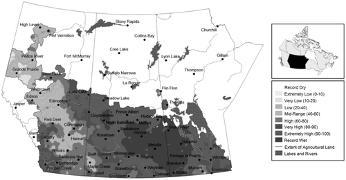
Towards the end of May, the water level on Lake of the Prairies, the reservoir for the Shellmouth Dam (see Blais et al. this issue), was drawn down to increase storage volume in case of summer flood events. Flows on the lower Assiniboine River were also increased in order to divert less water to Lake Manitoba through the Portage Diversion channel. By mid-June, the flow in the Assiniboine River upstream of Portage la Prairie had receded to approximately 300 m3/s and the flow diverted through the Portage Diversion channel was less than 50 m3/s. Although the spring freshet had not caused any flooding, the spring period was still extremely wet. The April–June precipitation amount over the Assiniboine River watershed was categorized as “extremely wet” to “record wet” when compared to historical data (Figure ), and the antecedent conditions were characterized by saturated soils and nearly full wetlands and prairie pothole storages.
Figure 1. Precipitation compared to historical distribution, 1 April–30 June 2014 (Agriculture and Agri-Food Canada Citation2014).
The weeks of 13 to 23 June brought widespread precipitation to the Assiniboine Basin, with rainfall amounts ranging from 30 to as much as 90 mm (Figure ). On 28 June, Environment Canada issued a rainfall warning for much of western Manitoba. A slow-moving low-pressure system was moving into southwest Manitoba, and it was forecast that much of southern and northwest Manitoba and the Interlake would receive 40 to 50 mm of rain by 1 July. During the last weekend of June, southern Saskatchewan and many parts of Manitoba experienced heavy rain caused by this low-pressure system. Some areas near the southern border between Saskatchewan and Manitoba received up to 200 mm of rain in a few hours.
Figure 2. Accumulated precipitation, 17–23 June 2014 (Agriculture and Agri-Food Canada Citation2014).
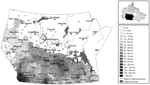
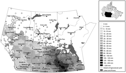
Figure shows accumulated precipitation for the period of 24 to 30 June. The rain system moving in from the west brought 50 to 200 mm of rain over the Assiniboine watershed. The Souris River watershed also received a significant amount of precipitation during the last weekend of June. The rainfall amounts were more than 200% of the average in the Souris River watershed located in North Dakota and Manitoba. These events caused flooding and high water levels in the Assiniboine River and many of its tributaries including the Qu’Appelle and Souris rivers.
Figure 3. Accumulated precipitation, 24–30 June 2014 (Agriculture and Agri-Food Canada Citation2014).
The course of the flood
The Assiniboine River rarely experiences major flood events generated solely from rainfall. Flood peaks are generally generated by a combination of snowmelt and rainfall and occur in spring. This was not the case in 2014, as the flood was due to a series of significant rainfall events that were above average and the final widespread low-pressure system which covered southern Saskatchewan and Manitoba and some parts of North Dakota. These systems collectively brought a significant amount of precipitation during the last 2 weeks of June and early July. The 2014 peak flood for Assiniboine River at Brandon was comparable to the maximum flow from the 2011 spring freshet, and was significantly higher than any summer flood on the Assiniboine River in the period of record since 1906 and with anecdotal observations that extend back to the flood of 1882.
Upper Assiniboine River
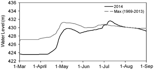
The 2014 flood was the largest summer peak experienced in the upper Assiniboine River. The peak flow on the Assiniboine River near Kamsack (05MD010), which is located approximately 80 km upstream of the Shellmouth Dam, was nearly 460 m3/s. This was 74% larger than any previously recorded summer peak, and only 8% smaller than the 2011 record spring flood (Figure ). The maximum inflow to the Shellmouth Dam reservoir during the 2014 summer flood was reported to be 520 m3/s, which was comparable to the 2011 flood peak of 566 m3/s at this location (MIT Hydrologic Forecast Centre Citation2014c). This flood elevated the reservoir water level to a maximum of 431.64 m (Figure ), a record high that was approximately 0.35 m and 0.50 m higher than reservoir levels during the 1995 and 2011 floods, respectively. The reservoir attenuated the flood peak by approximately 10%, and the maximum outflow was approximately 470 m3/s (MIT Hydrologic Forecast Centre Citation2014c).
Figure 4. 2014 provisional flows (dark lines) and recorded maximum daily discharges (gray lines) for the Assiniboine River (Kamsack 05MD004, Russell 05ME001, Brandon 05MH013 and Holland 05MH005), Qu’Appelle River (Welby 05JM001) and Souris River (Wawanesa 05NG001). The recorded maximum daily discharge represents the maximum daily value for each day over the entire record for each station.
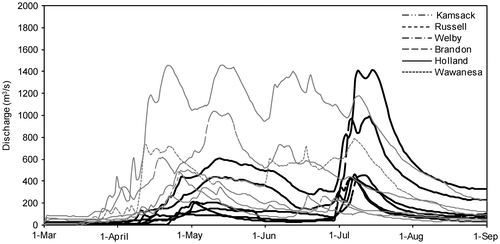
Figure 5. Provisional and recorded maximum daily water levels for 2014 upstream of the Shellmouth Dam. The recorded maximum daily water level represents the maximum daily value for each day over the entire record for each station.
The Qu’Appelle River joins the Assiniboine River downstream of the Shellmouth Dam, near the town of St. Lazare, Manitoba. An examination of the flows recorded at the Qu’Appelle River near Welby gauge (05JM001) in the period of record since 1912 demonstrates that the annual peak is almost always the result of the spring freshet. This gauge recorded two peaks for the summer 2014 event (Figure ). The first peak was on 30 June (325 m3/s) and the second was on 6 July (468 m3/s). The 6 July peak flood on this river was almost double the previously recorded summer flood, and nearly 36% larger than the previously recorded annual maximum at this station. It is likely that the first peak was generated as a result of local runoff, while the second peak was increased from coincident flows coming from the upper Qu’Appelle River watershed.
Lower Assiniboine River
The Assiniboine River near the city of Brandon (05MH013) experienced a relatively high flow in the spring of 2014 (10- to 20-year return period flood). MIT issued a spring flood warning for the upper Assiniboine River from Shellmouth Dam down to Brandon. The spring peak (440 m3/s) occurred in May and extended over a few weeks (Figure ). Water levels exceeded the top of bank in many reaches, resulting in overland flooding of some low-lying land adjacent to the river. The flow receded to approximately 146 m3/s by mid-June.
The 2014 summer peak of 1030 m3/s is comparable to the maximum flow recorded for Brandon since the Shellmouth Dam has been in operation. The hydrographs on Figure indicate that the magnitude of flow additions downstream of the Shellmouth Dam (recorded near Russell at station 05ME001) was less than half the peak flow at Brandon. The summer flood hydrograph at Brandon displayed two peaks similar to those of the Qu’Appelle River (Figure ). This is probably due to the two major rainfall events, with the majority of the runoff being generated downstream of Shellmouth. The rainfall amounts recorded at Brandon were 80 mm for the 19–20 June event and 138 mm for the 27–30 June event (Brandon Airport Station, Environment Canada 5010481).
The Souris River joins the Assiniboine River downstream of Brandon. Due to the nature of the contributing basin, this river commonly has a long protracted spring hydrograph with a second peak generated from the upstream reach. In some cases, this has coincided with rainfall-generated runoff to produce a peak that is the annual peak. These events are relatively rare and tend to be lower magnitude floods. The exception was the 2011 event, which broke flow records for both the largest flood and largest summer flood and had a maximum flow rate of 800 m3/s as recorded at the Souris River near Wawanesa gauge (05NG001). The Souris River at Wawanesa crested on 4 July 2014 with a peak flow of approximately 437 m3/s, which was slightly over half of the maximum summer flood recorded in 2011 (Figure ).
The Assiniboine River near Holland (05MH005) is located downstream of the confluence with the Souris River and upstream of the Portage Diversion. Flows observed and/or predicted for this location are critical to the operation of the diversion structure. This location experienced two flood peaks of similar magnitude 5 days apart (Figure ). The 2014 summer peak at this station was approximately 1450 m3/s, which is comparable to the maximum flow that occurred in 2011.
Portage Diversion
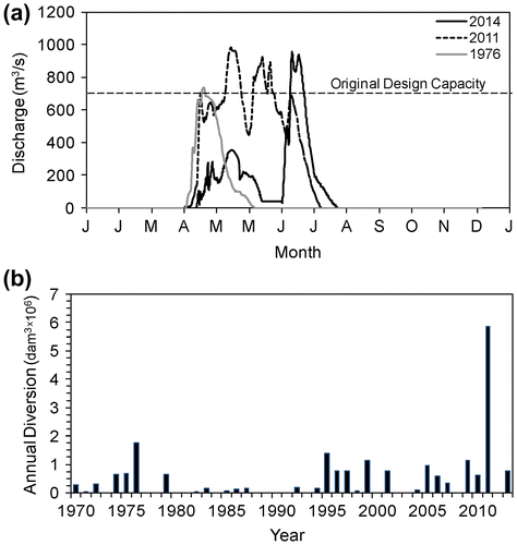
The Portage Diversion is located downstream of Holland and upstream of Portage la Prairie (see Blais et al. this issue). The capacity of the Portage Diversion was increased on an emergency basis in 2011 from the original design capacity of 700 m3/s to approximately 1000 m3/s (MIT Citation2013a). The 2011 flood also demonstrated that the Assiniboine River downstream of Portage la Prairie can convey flows as high as 510 m3/s without imposing an undue risk of breaching to its dikes. These relationships and the 2014 flows rates are displayed in Figure . This theoretical maximum flow is important in that flows over this threshold could cause an uncontrolled dike breach due to seepage (2011 Flood Review Task Force Report, 115). Due to the projected inflows possibly exceeding this threshold, preparations were made for a controlled breach at the Hoop and Holler Bend through Provincial Road 331. The controlled breach was not implemented in 2014.
Figure 6. Provisional flows recorded on the Assiniboine River (Holland 05MH005, Portage 05MJ003) and Portage Diversion (Portage 05LL019) from April to August 2014.
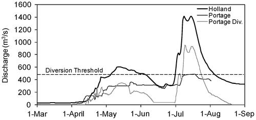
An estimated maximum flow of 531 m3/s was passed to the downstream reach of the Assiniboine River, and any flow exceeding this threshold was diverted to Lake Manitoba through the Portage Diversion (peak flow of 967 m3/s). Figure a shows the flow rates recorded through the Portage Diversion in 2014. The record flows of 1976 and 2011 are also included in this figure for comparison. During the operating period in 2014, approximately 2,200,000 dam3 was diverted to Lake Manitoba, 70% of which was during the period of the summer flood (July and August). This volume is the second largest diverted volume to Lake Manitoba since the operation of the channel commenced in 1970 (Figure b). The inflows from two main tributaries (Waterhen and Whitemud Rivers) were above normal but not near the inflow record for these two rivers.
Figure 7. (a) Flow rates through the Portage Diversion; (b) annual volume of water conveyed to Lake Manitoba through the Portage Diversion (1 dam3 = 1000 m3).
On 29 June, the Lake Manitoba water level was at 247.4 m and 248.06 m at the Westbourne (05LL012) and Steep Rock (05LK002) gauges located in the southern and northern basins of the lake, respectively. This situation was reversed on 1 July with the lake level being at approximately 248.6 m at the Westbourne station, while the water level was at 247.9 m at the Steep Rock gauge. These water levels were affected by the strong southern winds (83 km/hr) on 29 June, which shifted to 50 km/hr northern winds on 1 July (Oakpoint Marine Station, Environment Canada 504K0NM). The wind event on 1 July caused a significant wind setup and wave uprush on the south shoreline of Lake Manitoba, resulting in water overtopping the beach ridge separating Lake Manitoba from Delta Marsh.
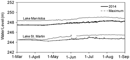
The Fairford River Water Control Structure (FRWCS) is the outlet from Lake Manitoba into the Fairford River. It has been operated for maximum possible discharge since 2011 to lower the lake level as much as possible. The lake level peaked at 248.34 m (excluding wind effects) in early August, as recorded at the Steep Rock station (Figure ). This was almost 0.76 m lower than 2011 lake level. The maximum outflow from Lake Manitoba through the FRWCS was approximately 435 m3/s on 9 August compared to a maximum outflow of 646 m3/s in 2011 (MIT Citation2014).
Figure 8. Provisional water levels and recorded maximum daily water levels for 2014 in Lake Manitoba (Steep Rock 05LK002) and Lake St. Martin (Hilbre 05LM005). The recorded maximum daily water level represents the maximum daily value for each day over the entire record for each station.
Lake St. Martin
The water level in Lake St. Martin peaked on 1 July 2014 at 245.15 m (approximately 244.9 m without wind setup), which is about 0.75 m above flood stage. The 2014 maximum lake level was 0.40 m lower than the historic peak of 2011; however, the lake levels were above the flood stage for the entire spring and summer seasons (Figure ). The Lake St. Martin Emergency Channel was partially reopened beginning on 6 July 2014. Outflow through this channel was measured at approximately 130 m3/s for the first 2 weeks, and then dropped to 100 m3/s (MIT Citation2014). The channel was expected to stay open until the spring of 2015 to help bring the Lake St. Martin water level down to approximately 244.45 m, therefore allowing for higher outflows from Lake Manitoba.
Statistical assessment
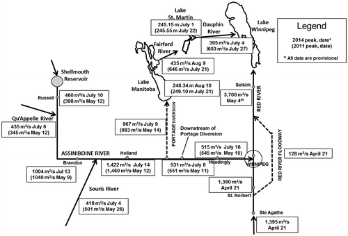
The initial assessment of the peak flows, using the provisional data from the WSC, shows that the 2014 flood peaks on Assiniboine River were comparable to the 2011 peak floods in spite of the differences in timing of these two events. Figure shows a comparison between magnitudes and timing of the 2014 and 2011 floods. The Qu’Appelle River set new records for flow in spite of this being a rare summertime event for this tributary. Peak outflows from the Shellmouth Dam were higher in 2014 than in the 2011 event, whereas the peak flow on the Souris River was significantly lower when compared to the 2011 peak. The 2014 recorded peak flows at Brandon, Holland and Portage gauges were slightly lower than the 2011 peaks at these stations. A major difference between the two flood events is that the 2011 flood was sustained for approximately 3 months. As a result, the volume of water diverted to Lake Manitoba in 2011 through the Portage Diversion was nearly 3 times larger than the diverted volume in 2014. The 2014 maximum levels of Lake Manitoba and Lake St. Martin were 0.76 m and 0.40 m lower, respectively, than the highest water levels recorded during the 2011 flood.
Figure 9. Peak flows and levels for 2014 and 2011 in the Lower Assiniboine Watershed.
The estimated return period of the 2011 flood at various locations in Manitoba is presented in the Manitoba 2011 Flood Review Task Force Report. Due to the occurrence of another extreme event so soon after the 2011 flood, the probabilities for the 2014 event, at various locations, are being recomputed by the Province of Manitoba. A frequency analysis was conducted using Assiniboine River near Brandon data adjusted for operation of the Shellmouth Dam (data provided by the Province of Manitoba). The data were analyzed using only the period of formal record from 1906 to 2014, and using historic data back to 1882. In this analysis, the United States Geological Survey (USGS) Bulletin 17B (USGS Interagency Advisory Committee on Water Data Citation1982) method was used to include historical floods of 1882, 1902 and 1904, and to calculate empirical return periods. This analysis would indicate that the 2014 event could have a return period of between slightly over 200 years to 400 years if considered part of the annual series of events (Figure ). Due to uncertainty in historical data and the 2014 flows being provisional, this result should be considered preliminary. The 95% confidence limits for both series are also calculated (Figure ). For both data sets, the accuracy of the computed flow frequency estimates using logarithmic regression reduces as the return period increases.
Figure 10. Frequency analysis of Assiniboine River flows (near Brandon). The black lines represent the logarithmic regression between peak flows and return periods, and the gray lines are the 95% confidence limits for each data set. The United States Geological Survey Bulletin 17B method was used for including historical floods of 1882, 1902 and 1904. The empirical equation T = (N + 0.2)/(r – 0.6) was used to calculated the plotting position [T = return period (year), N = no. of data, and r = rank].
![Figure 10. Frequency analysis of Assiniboine River flows (near Brandon). The black lines represent the logarithmic regression between peak flows and return periods, and the gray lines are the 95% confidence limits for each data set. The United States Geological Survey Bulletin 17B method was used for including historical floods of 1882, 1902 and 1904. The empirical equation T = (N + 0.2)/(r – 0.6) was used to calculated the plotting position [T = return period (year), N = no. of data, and r = rank].](/cms/asset/f17b6db6-c81f-484d-a02c-2f0e99cac2e7/tcwr_a_1070695_f0010_b.gif)
A frequency analysis of summer peak flows (July–September) was also performed for the period record from 1906 to 2014. The fact that the 2014 flood is a summer event when almost all the other annual events are spring freshet events would indicate that the probability of this event occurring should be significantly smaller than what the annual peak flows analysis would indicate (Figure ).
Flood damages
The 2014 Assiniboine River summer flood in southern Manitoba and Saskatchewan caused damages that may exceed several hundreds of millions of dollars. This flood washed out roads and bridges, flooded farmers’ fields, and caused severe damage to properties, riverbanks, and dikes. Approximately 30 bridges or culverts in southwestern Manitoba were identified as needing replacement, with another 50 structures needing significant repairs (Government of Manitoba Citation2014). The Manitoba government advises that a preliminary estimate of repair costs for roads and bridges in western Manitoba is in excess of CAD $200 million. In Saskatchewan, 2014 flood damages are expected to exceed the CAD $360 million in damage incurred during the 2011 flood. The timing of this flood made it more costly than the 2011 flood from a farming perspective, since most farmers had already planted their crops. According to the Keystone Agricultural Producers, at least 2 million acres of Manitoba farmland was either not seeded or seeded but lost to water damage by mid-July. This number was expected to increase to 3.5 million acres by the end of flood season (CBC News Citation2014). In Saskatchewan, it was estimated that a total of up to 3 million acres were flooded by mid-July (CTV News Citation2014) from the heavy rain and riverbank spill.
Summary
The 2014 flood event on the Assiniboine River and its tributaries was unlike any prior flood on this river. It was caused by a series of significant rainfalls that occurred in late June and early July over a large proportion of the river basin in Manitoba and Saskatchewan, rather than by snow melt and spring rains. Extreme flood conditions were experienced over the entire length of the Assiniboine, Qu’Appelle and Souris rivers, and along many tributaries. The magnitude of the flood peaks on the Lower Assiniboine was similar to those of the 2011 flood, but the 2014 flood was less severe on the Souris River. The spatial scale of this flood was also comparable to the 2011 flood, but its duration was much shorter. The impact of this flood on the Lake Manitoba and Lake St. Martin water levels was not as extreme as in 2011, when the diversion was operated for 126 days. Much less water was added to Lake Manitoba in 2014, although it still ranks as the second largest volume of water artificially added to this lake since 1970.
The fact that the Assiniboine River Basin has been subjected to two record-breaking floods in 3 years requires a fresh look at the previous statistical analysis of flood peaks for this river. The inclusion of the historic floods of 1882, 1902 and 1904 in this analysis would suggest that recent floods on the Assiniboine River were not as rare as previously estimated. The summer event of 2014 remains an outlier; it occurred during the summer, unlike any previous flood in the Assiniboine River. It is difficult to assess the return period of the event as it does not resemble any other flood in the record. This may also be an indication of a change in the hydrological regime in the Assiniboine River basin, and that floods in the future may be affected by the combined effects of land-use changes such as drainage network extension, and increased climate variability.
References
- Agriculture and Agri-Food Canada. 2014. Drought Watch website, map archive. http://www.agr.gc.ca/DW-GS/historical-historiques.jspx?lang=eng&jsEnabled=true (accessed November, 2014).
- Blais, E., S. Clark, K. Dow, B. Rannie, T. Stadnyk, and L. Wazney. This issue. Background to flood control measures in the Red and Assiniboine river basins. Canadian Water Resources Journal. doi:10.1080/07011784.2015.1036123
- Blais, E., J. Greshuk, and T. Stadnyk. This issue. The 2011 flood event in the Assiniboine River Basin: Causes, assessment and damages. Canadian Water Resources Journal. doi:10.1080/07011784.2015.1046139
- CBC News. 2014. Flood of 2014 a $1B hit for Manitoba farmers: KAP. 10 July. http://www.cbc.ca/news/canada/manitoba/flood-of-2014-a-1b-hit-for-manitoba-farmers-kap-1.2702848 (accessed November, 2014).
- CTV News. 2014. Prairie farmers frustrated as flooding drowns crops. 13 July. http://www.ctvnews.ca/canada/prairie-farmers-frustrated-as-flooding-drowns-crops-1.1911605#ixzz3CRzQdXKI (accessed November, 2014).
- Government of Manitoba. 2014. Summer flood bulletins. 23 June–24 July. http://www.gov.mb.ca/flooding/news_bulletins.html (accessed November, 2014).
- Manitoba Infrastructure and Transportation (MIT). 2013a. Manitoba 2011 Flood Review Task Force, report and appendices. Report to the Minister of Infrastructure and Transportation, April. Winnipeg.
- Manitoba Infrastructure and Transportation (MIT). 2013b. 2011 flood: Technical review of Lake Manitoba, Lake St. Martin and Assiniboine River water levels, October. Winnipeg.
- Manitoba Infrastructure and Transportation (MIT). 2014. July daily flood sheets. http://www.gov.mb.ca/mit/floodinfo/floodoutlook/forecasts_reports.html#daily_flood_reports (accessed November, 2014).
- Manitoba Infrastructure and Transportation (MIT). Hydrologic Forecast Centre. 2014a. First spring flood outlook for Manitoba, 28 February. http://www.gov.mb.ca/mit/floodinfo/floodoutlook/forecasts_reports.html#spring_flood_outlook (accessed November, 2014).
- Manitoba Infrastructure and Transportation (MIT). Hydrologic Forecast Centre. 2014b. Second spring flood outlook for Manitoba, 31 March. http://www.gov.mb.ca/mit/floodinfo/floodoutlook/forecasts_reports.html#spring_flood_outlook (accessed November 2014).
- Manitoba Infrastructure and Transportation (MIT). Hydrologic Forecast Centre. 2014c. Shellmouth Reservoir. http://www.gov.mb.ca/mit/floodinfo/floodoutlook/lakes_information.html#lake_levels (accessed November, 2014).
- Pomeroy, J. W., K. Shook, X. Fang, S. Dumanski, C. Westbrook, and T. Brown. 2014. Improving and testing the Prairie Hydrological Model at Smith Creek Research Basin. Centre for Hydrology Report No. 14, Saskatoon, SK: University of Saskatchewan.
- United States Geological Survey (USGS) Interagency Advisory Committee on Water Data. 1982. Guidelines for determining flood-flow frequency. Bulletin 17B of the Hydrology Subcommittee. Reston, VA: Office of Water Data Coordination, USGS.