
Abstract
Despite global mitigation efforts, climate change will impact the City of Vancouver’s future. One anticipated impact, sea level rise, is described. A comprehensive understanding of the consequences of these impacts is necessary to guide the process of identifying preferred adaptation strategies. A methodology for a coastal flood risk assessment (CFRA) of sea level rise is provided. The inputs for this risk assessment include inundation mapping and an asset-at-risk inventory. These data sets are combined with flood damage information from Hazus to look at consequences of coastal flooding. There are many uncertainties and gaps in the process of developing a CFRA for a modern, dense, urban city such as Vancouver, particularly when the planning timelines required for preparing and adapting to sea level rise are long. The value of the process and results include increased understanding of hazards and vulnerabilities, and the development of useful visual tools for engagement, planning and education.
En dépit des initiatives d’atténuation, le changement climatique influera sur l’avenir de Vancouver. L’un des impacts prévus, l’élévation du niveau de la mer, est décrit. Une compréhension globale des conséquences de ces impacts est nécessaire afin d’orienter le processus de détermination des stratégies d’adaptation privilégiées. Une méthodologie est proposée pour l’évaluation des risques d’inondation côtière (ERIC) dans un contexte d’élévation du niveau de la mer. Les données d’entrée pour cette évaluation des risques comprennent les cartographies des inondations et un inventaire des biens menacés. Ces ensembles de données sont combinés aux renseignements sur les dommages causés par les inondations tirés du logiciel Hazus, dans le but d’examiner les conséquences des inondations côtières. Il existe de nombreuses incertitudes et lacunes entourant le processus de création d’un outil ERIC pour une ville moderne, urbaine et densément peuplée comme Vancouver, en particulier dans le cas d’un long horizon de planification exigé pour la préparation et l’adaptation à l’élévation du niveau de la mer. La valeur du processus et ses résultats englobent une meilleure compréhension des risques et des vulnérabilités, ainsi que l’élaboration d’outils visuels utiles pour la participation, la planification et la sensibilisation.
Introduction
The City of Vancouver (Vancouver) has been listed among the most vulnerable cities in the world to coastal flooding (Hallegatte et al. Citation2013) due to the density of waterfront development, and vulnerable port and transportation systems. A significant percentage of parks and open space that support Vancouver’s reputation as one of the most liveable cities also line the shore. Furthermore, the city relies heavily on its coast for economic activity, including shipping and tourism.
In 2007, after the release of the Intergovernmental Panel on Climate Change’s fourth assessment report, the City of Vancouver Council directed staff to investigate impacts that could be anticipated from climate change. The city’s 2012 Adaptation Strategy identified flooding from heavy rainfall as well as river and ocean flooding as key impacts (City of Vancouver Citation2012). Strategy implementation actions included designing and undertaking a coastal flood risk assessment (CFRA); this paper describes part of this action.
The goal of the assessment is to better understand current and future flood risk; to identify the areas, infrastructure and neighbourhoods that may become vulnerable as exposure to the hazard changes; to assess consequences at a high level (Phase 1); and to explore options ranging from protection through sea dikes to accommodating via land use management (Phase 2). Much of climate change adaptation work involves making decisions with imperfect information and many assumptions. The risk assessment provided clear steps to start framing the decision-making and to provide learning opportunities for a range of staff, stakeholders and community members along the way. This paper summarizes steps in Phase 1 of the project with a focus on the challenges encountered.
Study location
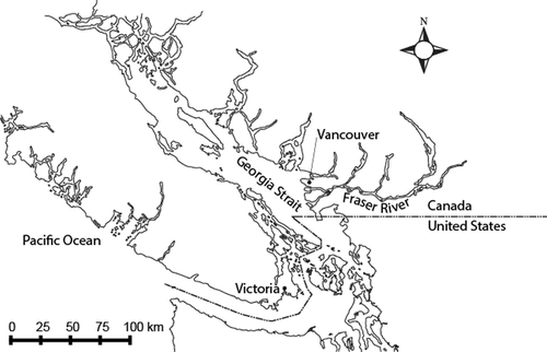
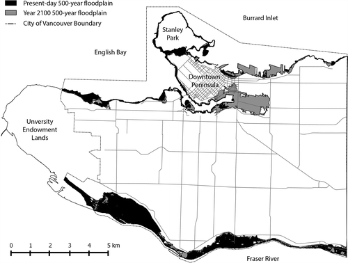
Vancouver’s shoreline abuts the Georgia Strait and the Fraser River (Figure ), and includes over 18 km of beach and 17 ha of natural shoreline habitat. Most of the City’s shoreline is coastal, including the downtown core which is located on the peninsula in the northwest. In addition to the shoreline that directly interfaces with the ocean, water elevations on the portion of the Fraser River bordering Vancouver are dominated by the backwater effects of the ocean, and therefore flooding hazard in the City is predominantly coastal. The existing coastal flood hazard results from elevated ocean levels which are a function of tide, storm surge and other local effects.
Figure 1. Location and detail of Vancouver, Canada.
Flood risk changes in a future climate in Georgia Basin related to sea level rise
The Intergovernmental Panel on Climate Change (2013) reports that ocean thermal expansion and glacier melting have been the dominant contributors to twentieth-century global mean sea level rise. Relative sea levels are important in coastal areas, particularly in deltas where relative sea levels are affected by vertical land motion. The amount of future sea level rise is somewhat uncertain, but in Vancouver local water levels are expected to increase by approximately 1 m (from year 2000 levels) by 2100 (Bornhold Citation2008).
Flood risk in Vancouver: what do we need to know and why?
Resilience-building actions and new regulations often occur following a natural hazard event such as a large flood or landslide. Sea level rise-related flood hazard presents the novel challenge of long-term proactive planning for a hazard that is known to be changing but with imprecise knowledge of magnitude, extent and frequency of those changes. What is clear is that infrastructure built today, and people living in low areas, will be exposed to increased hazard throughout their lifetime.
As countries and cities try to adapt to a changing climate, flood risk assessment is widely considered to be the best tool to make decisions that will mitigate flood impacts over time (European Commission Citation2003; Jha et al. Citation2012) and is being employed widely (e.g. Australia [Queensland Reconstruction Authority Citation2013]; New Zealand [Rouse Citation2011]; Japan, Netherlands and the United States [US Army Corps of Engineers et al. Citation2011]; and the UK [UK Environment Agency Citation2009]). Risk assessment for flood management is only in its infancy in Canada, where regulatory standards-based management has been the norm (Sandlink et al. Citation2016, this issue).
Flood risk is a function of both the likelihood of an event occurring and the consequences of that event occurring (Figure ). Flood consequence is defined as a function of flood hazard (where will the water go?) and vulnerability (what’s in the way?). Risk is a function of both likelihood and consequence (Figure ), which helps decision-makers consider and compare both a high likelihood, low-consequence event and a low-likelihood, high-consequence event on an equal footing. This becomes particularly important across long time horizons. A catastrophic flood that occurs just once might have fewer impacts than a series of nuisance floods that occur annually over several decades; a flood risk assessment can be used to compare both the impacts and the potential benefits of mitigation options for the entire spectrum of potential events.
Figure 2. Flood risk as a function of hazard, likelihood and vulnerability.
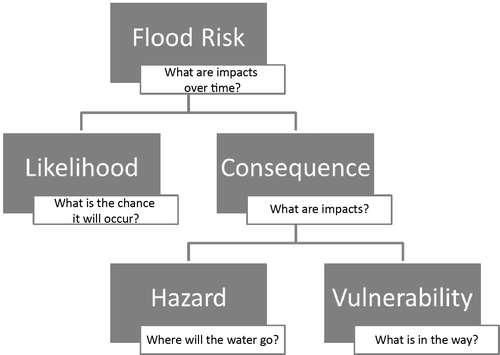
Figure 3. Risk as a function of likelihood and consequence.
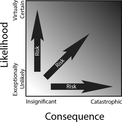
Figure 4. Source–pathway–receptor model for flood risk.
Taking a risk-based approach to flood management incorporates the things people care about and thereby touches more stakeholders, especially when they are involved in the learning. Considering vulnerabilities and consequences also lays the groundwork for comparing alternative response strategies in a quantitative and qualitative manner; decision-makers are generally comfortable weighing impacts and benefits.
Flood consequences or impacts
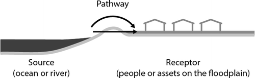
The source–pathway–receptor model is a common method of looking at flood risk, where the impacts are defined by the “receptors” or elements at risk on a floodplain (Messner et al. Citation2006; Royal Institute of British Architects n.d.). These include (1) people, (2) buildings/infrastructure, (3) natural environments and (4) the economies that link them. These groupings are one means of considering and organizing flood impacts for practical reporting; however, it must be noted that there are many linkages and common elements between these groups.
Flood impacts can be further divided into direct and indirect impacts. Direct impacts describe all harm that relates to the immediate physical contact of water to people, infrastructure and the environment. Examples include damages to buildings, impacts to building contents and other assets, damage to the environment and loss of human life. Indirect impacts are those caused by the disruption of the physical and economic links in the region, as well as the costs associated with the emergency response to a flood. Examples of indirect losses include business losses because of interruption of normal activities and costs associated with traffic disruption when roads are impassable.
Flood effects on the environment, human or community health, and the loss of life are considered intangible impacts, which are typically difficult to quantify. The losses from a damaged building or ruined inventory in a warehouse are considered tangible impacts, and are more easily calculated. This does not mean that tangible losses are more important than the intangibles, just that they are easier to quantify and assess. The inclusion of intangible impacts, while more challenging, is desirable for the development of a robust flood risk assessment (Messner et al. Citation2006). Davies (2016, this issue) similarly indicates the importance of the intangible impacts, which can have more lasting impact than the tangible impacts.
Estimates of potential flood impacts are an essential piece of a flood risk assessment (Figure ). A general approach to estimating flood impacts is to first assess potential flood damages to the various elements at risk: people, infrastructure, environment and the economy. This in turn is translated into a cost or loss by considering the amount of money or other resources required to repair, rebuild, replace or move the damaged structure. Similar, although more subtle, calculations can be made to look at damages and losses to people, the environment and the economy; these calculations tend to be more difficult as the impacts are either indirect or intangible.
Flood damage estimation in the past has been in the engineer’s domain and focused largely on economic valuation of infrastructure and building losses (Messner and Meyer Citation2006). Transitioning from flood planning and damage mitigation using a standards-based approach to a more holistic risk-based approach to flood mitigation has resulted in a significant increase in the knowledge base around flood impacts. It brings various domains together, allowing improved discussion of the resilience of systems such as food distribution or transportation. However, both validated research and tools to evaluate intangible impacts need to be improved to ensure they receive equal consideration to those direct impacts that have clear quantitative results.
Flood impacts in the City of Vancouver
Flood consequence is a function of both the flood hazard and the vulnerability of the elements in the way of the flood (Figure ). For the City of Vancouver, detailed hazard mapping has been developed as a major component of the CFRA project, and key vulnerabilities have been identified. These are summarized below.
Identified hazards in the City of Vancouver
Vancouver is surrounded on three sides by water: ocean coastlines to the north and west, and the Fraser River to the south (Figure ). All of the shorelines are directly impacted by fluctuations in coastal sea levels. The water level is a function of deterministic tidal fluctuations as well as probabilistic increases resulting from storm and wind surge and set-up (Figure ). Vancouver local water levels will increase by approximately 1 m (from year 2000 levels) by 2100 (Bornhold Citation2008). This 1 m will not have a uniform impact given the variable shoreline topography, but it will have a significant impact on the areal extent of the coastal floodplains (Figure ).
Figure 5. Coastal flood levels for the present and with sea level rise (SLR).
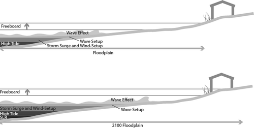
Figure 6. Coastal floodplain of City of Vancouver for the present and with sea level rise.
A detailed hazard assessment that considers a broad spectrum of events with various probabilities and time scales was developed based on five coastal flood scenarios. Scenarios were determined by a technical committee including City of Vancouver staff, external practitioners, academics and flood experts. The details of the five scenarios that were selected and modelled are described in Table . Modelling and mapping efforts included coastal modelling of the Georgia Strait using a continuous simulation approach (NHC et al. Citation2014) to capture the joint probability of the various coastal components (tide, wave effect, wind effect, etc.) occurring together. Details on the model development including validation are described in full in NHC et al. (Citation2014).
Table 1. Summary of hazard scenarios.
There are some limitations to the modelling, especially related to the uncertainty of modelling future storm conditions based on a historic record. However, this hazard assessment provides the best available information of what areas of the city might be impacted by sea level rise and coastal flooding in future.
Identified vulnerabilities in the City of Vancouver
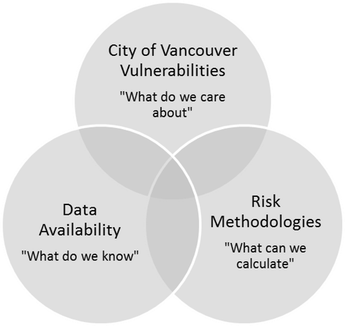
A high-level vulnerability assessment was conducted that explored what elements could be at risk on the floodplains. A stakeholder workshop was key to the assessment given the vast range of land uses and critical infrastructure elements located in the floodplains. Participants were asked to draw and comment on maps showing various levels of modelled flooding. Guiding questions included “What’s in the way?” and “What do we care about?” on the city’s floodplains. A summary of key vulnerabilities identified is listed in Table .
Table 2. Summary of identified vulnerabilities to coastal flooding.
Stakeholders identified a diversity of vulnerabilities in the floodplain, from transportation and communications infrastructure to key social services for vulnerable populations. Many of the vulnerabilities are indirect impacts (e.g. economic losses from the closure of tourist destinations), or are intangible (e.g. the potential loss of heritage and cultural sites). Indirect impacts were also considered, but for brevity are not presented here.
Calculating consequences in the City of Vancouver using the Hazus model
Hazus is a standardized methodology for calculating potential losses from natural hazards and is widely used across the United States. It was designed as a planning-level tool for local governments and agencies to develop emergency management and mitigation plans (Department of Homeland Security, Federal Emergency Management Agency Citation2009a). Adapting Hazus for use in Canada began in 2011 (Nastev and Todorov Citation2013). The earthquake module was the initial focus of the effort; the addition of the flood module for Canada is still in its infancy. At this time, only a beta version is available from Natural Resources Canada. The Canadian version of Hazus is based on the US version, and the flood module is virtually unchanged (N. Hastings, Hazus Canada activity lead, Natural Resources Canada, pers. comm. 2014).
The City of Vancouver selected Hazus as the primary tool for flood consequence assessment for several reasons. First, this tool had recently been adopted by the federal government, and, second, the city could garner a co-benefit by preparing an asset inventory for both the earthquake and flood hazard assessments.
Hazus, like most risk assessment tools, calculates direct tangible damages and losses, providing a significant amount of information about buildings in particular. However, Hazus provides only some indirect tangible damages and losses and limited loss information pertaining to people, or indirect economic losses. The calculations are mostly based on large-scale classifications of building stock and demographics, but there is the opportunity to refine this information with user-defined facility information. Both approaches have been applied for the City of Vancouver assessment.
Damage and loss results are calculated based on an inventory of assets on the floodplain and the hazard (where and how deep is the water?). This information is then combined with damage and loss curves (Figure ) from the Hazus database to produce hazard- and site-specific consequence information (Figure ). The City of Vancouver and national Statistics Canada databases were not designed with flood damage estimation in mind, and as such many proxies were required to populate the asset inventory. This is, of course, a source of additional uncertainty to the CFRA process.
Figure 7. Generic depth–damage curve (after Nastev and Todorov Citation2013).
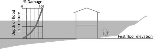
Figure 8. Hazus structure (adapted from Department of Homeland Security, Federal Emergency Management Agency Citation2009b).
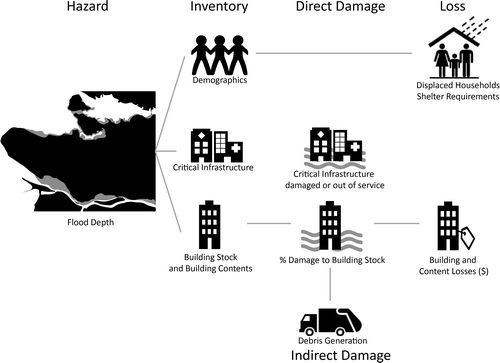
Outputs for the CFRA from the Hazus model include spatial representations of potential displaced households and shelter requirements, numbers of damaged critical infrastructure buildings, a spatial representation of building (and content) damages and losses, and debris volumes from damaged buildings.
The Hazus model was run for each of the scenarios described in Table and provides a rich resource of information on the relative damages and losses for each of the scenarios, especially for the building stock. However, over the course of the project many uncertainties and gaps in the use of Hazus for a densely developed city like Vancouver were identified. In particular, uncertainties in the applicability of the default stage–damage and loss curves emerged. Stage–damage curves are a key component of Hazus modelling and flood consequence modelling in general. Research has shown that, along with information about the assets, depth–damage curves are the most important source of uncertainty in consequence modelling (Bubeck et al. Citation2011; Jongman et al. Citation2012) and can affect the end results by a factor of two (Moel and Aerts Citation2010). Three of the numerous concerns that emerged throughout the project are detailed below.
| (1) | Transferability of stage–damage curves: Research has shown that stage–damage curves are not directly transferable from region to region, and that care should be taken to at least select curves from related regions with similar flood and building characteristics (Cammerer et al. Citation2013). The Hazus default curves are primarily based on empirical evidence from midwestern and southern US towns (Department of Homeland Security, Federal Emergency Management Agency Citation2009b), which are anecdotally significantly different from Vancouver. | ||||
| (2) | Omission of velocity from damage curves: Velocity is known to be a key factor in the damage of buildings in a flood; however, few empirical databases exist that describe expected damage under a combination of depths and velocities (Kelman and Spence Citation2004; Middelmann-Fernandes Citation2010). Velocity is not used in the default Hazus curves at this time. Kreibich et al. (Citation2009) suggests that this may not be an oversimplification for damage to buildings, although road damage is highly sensitive to velocity. At present, road damage is not considered in Hazus. | ||||
| (3) | Wave damage omission: Similar to velocity, intuitively it makes sense that waves would damage buildings more than slack water would. Hazus does have a coastal damage feature enabled; however, the relative difference in the damage curves for a riverine versus a coastal zone is negligible. This is a known problem with Hazus that has been recognized by the developers. For example, based on recent validations the coastal damage functions are incorrect, only estimating 33% of the actual loss – especially for high-rise buildings such as those found in Vancouver (Todorov Citation2013). Hazard mapping for this project has shown that only a few areas would be subjected to significant waves. | ||||
Results
The modelling showed significant anticipated impacts to buildings and people for coastal flood events in the present day, and increasingly in the future. In the present day, a 500-year (0.2% chance of occurring in a given year) event would result in 1700 displaced households and almost 500 damaged buildings. The same storm event with 1 m of sea level rise would incur dramatically more impacts: 4000 displaced households with over 800 damaged buildings. The majority of the damaged buildings are residential but there are also a significant number of industrial buildings impacted, particularly along the Fraser River. The Hazus model estimated that the debris generated from the 1:500 storm event with 1 m of sea level rise would fill 4500 trucks – enough to cause a significant waste management concern for the city and the region.
The Hazus model was also used to estimate direct damage costs. However, due to difficulties in adapting a US tool to Vancouver (as described in this paper), the resulting costs were considered unreliable. Further, while the Hazus model can provide direct damage estimates, there are a significant number of more intangible or less directly calculable impacts that are not calculated by Hazus. An example of a significant indirect cost for flooding in Vancouver would be the economic impacts resulting from disruption to an electrical distribution facility or a major transit station. While Hazus is clearly a useful tool for evaluating the potential consequences of a flood, further work is needed to refine the model for use in the Canadian context.
Challenges
In work related to climate change adaptation or natural hazard risk reduction, waiting for perfect information may result in missed opportunities to build cities appropriately, incurring further future risk and potentially increasing costs of desirable mitigation alternatives as time goes on. For instance, developing a dense new waterfront community today at low elevations without space for a future dike or flexible ground-level space may constrain adaptation alternatives in the coming decades.
Despite the challenge of working under uncertainty, it is still important that decision-makers act to reduce future flood risk. Good decisions can still be made with imperfect information, particularly if adaptable solutions are promoted. Decision-makers, however, would need to have more complete information to rely on, and communicate to senior levels of government whether some of the gaps could be filled in.
Furthermore, it is important to make the various uncertainties and assumptions associated with a flood risk process clear and explicit. For example, in Table above, which outlines the key elements at risk on the floodplain, the only element that can be reliably calculated using the available data and risk methods is damage and loss to low-rise residential structures (see also Figure ).
Figure 9. Model to assess gaps in coastal flood risk assessment (CFRA).
Identified value in the CFRA
Over the course of the project, many uncertainties and gaps in the process of developing a CFRA for Vancouver were recognized. Despite the gaps, the assessment yielded increased understanding of hazards and vulnerabilities, and the development of useful visual tools for planning, public engagement and education:
| | Increased knowledge of hazards: The hazard mapping provided the City of Vancouver with detailed floodplain maps. These provide value to the city as they inform the current standards-based policies (e.g. flood construction levels), and the hydrodynamic model results include depths and velocities, which can be used for emergency management mapping. Maps are excellent visual resources and when the range of scenarios are shown together, audiences begin to grasp both the complexities of climate change planning and the simple messages they embody. Stakeholders important to city resilience and post-disaster recovery were able to begin identifying the infrastructure such as telecommunications and power that could be affected in the future. | ||||
| | Increased knowledge of relative difference between hazard scenarios and exposure: The CFRA identified changes to the floodplain extents and depths over time with sea level rise. The inundation mapping clearly shows regions of the city that require prioritization in the short term, and those that will only surpass flood thresholds in the future. Cross-referencing the mapping with the type of built form density in the area, and the current zoning, helped identify considerations for short-term planning. It was also immediately input into large planning and infrastructure projects. | ||||
| | Increased knowledge of vulnerabilities: The CFRA included an assessment of vulnerable assets on the existing and future floodplains. The vulnerability workshop resulted in improved awareness, new relationships and emerging priorities. Several policy areas have been directly affected by the work. | ||||
| | Increase in city engagement and capacity: Many people were involved in the CFRA. Interaction with the stakeholders has increased awareness on the issue of climate change, and the need to prepare for and adapt for its impacts. Numerous maps (hazards, vulnerability hotspots, consequence hotspots) and other visual aids have been developed for this project that will continue to aid in engagement and education. | ||||
| | Increased understanding of gaps: Risk assessment has been proven in numerous areas to be an effective decision-making tool. Identifying and documenting the gaps and uncertainties of the new application to coastal flooding will strengthen the process and spur development of the missing tools. | ||||
Conclusions
The City of Vancouver is located in a climate-sensitive region, and is likely to be affected by the direct impacts of climate change and sea level rise. While many aspects of the climate of Georgia Basin are expected to change in future, an approach being used to examine the flood risk associated with sea level rise for the City of Vancouver has provided an example of how these changes in risk can be assessed. Despite gaps and uncertainties, there was considerable value in the process and results of the first phase of the CFRA, including increased understanding of vulnerabilities, increased knowledge about the relative difference between hazard scenarios and the development of useful visual tools for engagement, planning and education.
From the outset of the CFRA, the primary uncertainty was the unknown rate of local sea level rise over a 100-year planning horizon. Throughout the course of the project (Phase 1), it became clear that in addition to the uncertainty of sea level rise, there was also uncertainty associated with modelling flood hazard. Layered onto this were the many gaps between the elements at risk on the floodplain that were recognized priorities, and the ability to estimate the potential consequences to these elements. Clearly, methods are needed that will allow intangible and indirect impacts of floods to be quantified to support a risk-based approach.
The results, with the identified gaps and assumptions, do identify priority areas and provide for relative comparisons between possible response strategies; these are being used in Phase 2 of the project currently underway. Further refinement of the risk assessment tools will better support reliability of the information for complex decisions.
As coastal cities grapple with climate change and sea level rise, there is a need to begin planning now in order to reduce the impacts of coastal floods in the future. This need far outweighs the risk of moving ahead with imperfect information. Practitioners and politicians need to recognize that even an imperfect risk calculation using the best available tools and data will help to make informed decisions. These decisions will hopefully increase the resiliency to coastal flooding in a changing climate.
Acknowledgements
A large and diverse team was involved in the City of Vancouver CFRA project. This includes city staff in the Sustainability Group, Engineering Services and in GIS and CADD services. Northwest Hydraulic Consultants Ltd. managed the CFRA project and completed the hazard modelling and mapping with help from Cascadia Coast Research Ltd. Figure is based on flood map information provided by Northwest Hydraulic Consultants Ltd. The Arlington Group Planning and Architecture Inc. completed the baseline vulnerability assessment. Ebbwater Consulting developed the consequence analyses and provided continuity to the project. CFRA Phase 1 project advice and review was provided by a broad spectrum of government bureaucrats and academics from Natural Resources Canada and the University of British Columbia. Additional review of this paper was provided by Brad Badelt of the City of Vancouver, who is one of the project managers for the Phase 2 work.
References
- Bornhold, B. 2008. Projected sea level changes for British Columbia in the 21st century in publication. Government of British Columbia.
- Bubeck, P., H. de Moel, L. M. Bouwer, and J. C. J. H. Aerts. 2011. How reliable are projections of future flood damage? Natural Hazards and Earth System Science 11: 3293–3306.
- Cammerer, H., a. H. Thieken, and J. Lammel. 2013. “Adaptability and Transferability of Flood Loss Functions in Residential Areas.” Natural Hazards and Earth System Science 13 (11): 3063–81. doi:10.5194/nhess-13-3063-2013.
- City of Vancouver. 2012. Climate change adaptation strategy. http://vancouver.ca/files/cov/Vancouver-Climate-Change-Adaptation-Strategy-2012-11-07.pdf. Accessed January 15, 2013.
- Davies, J.B. 2015. “Economic Analysis of the Costs of Flooding.” Canadian Water Resources Journal. doi:10.1080/07011784.2015.1055804.
- Department of Homeland Security, Federal Emergency Management Agency. 2009a. Flood Information Tool user manual.
- Department of Homeland Security, Federal Emergency Management Agency. 2009b. Hazus – MH: Flood model technical manual.
- Ec.europa.eu. 2003. Best Practices on Flood Prevention , Protection. Ec.Europa.Eu: 1–29. http://ec.europa.eu/environment/water/flood_risk/pdf/flooding_bestpractice.pdf. Accessed May 2013.
- Hallegatte, S., C. Green, R. J. Nicholls, and J. Corfee-Morlot. 2013. Future flood losses in major coastal cities. Nature Climate Change 3 (9): 802–806.
- IPCC. 2007. “IPCC Fourth Assessment Report (AR4).” IPCC 1: 976. doi:ISSN: .
- IPCC Working Group 1. 2014. “IPCC Fifth Assessment Report (AR5) - The Physical Science Basis.” IPCC.
- Jha, A. K, R. Bloch, and J. Lamond. 2012. Cities and flooding: A guide to integrated urban flood risk management for the 21st century. World Bank Publications.
- Jongman, B., H. Kreibich, H. Apel, J. I. Barredo, P. D. Bates, L. Feyen, A. Gericke, J. Neal, J. C. J. H. Aerts, and P. J. Ward. 2012. Comparative flood damage model assessment: Towards a European approach. Natural Hazards and Earth System Science 12: 3733–3752.
- Kelman, I., and R. Spence. 2004. An overview of flood actions on buildings. Engineering Geology 73: 297–309.
- Kreibich, H., K. Piroth, I. Seifert, H. Maiwald, U. Kunert, J. Schwarz, B. Merz, and A. H. Thieken. 2009. Is flow velocity a significant parameter in flood damage modelling? Natural Hazards and Earth System Science 9 (5): 1679–1692.
- Messner, Frank, and V Meyer. 2006. Flood damage, vulnerability and risk perception - challenges for flood damage research. Flood Risk Management Hazards Vulnerability and Mitigation Measures. http://econstor.eu/bitstream/10419/45258/1/489068715.pdf. Accessed May 2013.
- Messner, F., E. Penning-Rowsell, C. Green, V. Meyer, S. Tunstall, and A. van der Veen. 2006. Guidelines for socio-economic flood damage evaluation. FLOODSite Report Number T9-06-01.
- Middelmann-Fernandes, M. H. 2010. Flood damage estimation beyond stage–damage functions: An Australian example. Journal of Flood Risk Management 3: 88–96.
- Moel, H., and J. C. J. H. Aerts. 2010. Effect of uncertainty in land use, damage models and inundation depth on flood damage estimates. Natural Hazards 58 (1): 407–425.
- Nastev, M., and N. Todorov. 2013. Hazus: A standardized methodology for flood risk assessment in Canada. Canadian Water Resources Journal 38 (3): 223–231.
- NHC, Ebbwater Consulting, and Arlington Planning and Architecture Ltd. 2014. City of Vancouver Coastal Flood Risk Assessment. Phase 1 Report. Prepared for City of Vancouver. December.
- Queensland Reconstruction Authority. 2013. “Planning for Stronger , More Resilient Floodplains: Part 1.” http://qldreconstruction.org.au/u/lib/cms/Planning-for-stronger-more-resilient-flo.pdf. Accessed January 2014.
- Rouse, Helen. 2011. “Flood Risk Management in New Zealand: Where Are We, and Where Are We Going?” GNS Science Report 2012/04, December 2011, no. April.
- Royal Institute of British Architects. n.d. Climate change toolkit designing for flood risk. http://www.architecture.com/Files/RIBAHoldings/PolicyAndInternationalRelations/Policy/Environment/2Designing_for_floodrisk.pdf (accessed January, 2014).
- Sandink, Dan, Paul Kovacs, Greg S Oulahen, and Dan Shrubsole. 2016. “Public Relief and Insurance for Residential Flood Losses in Canada: Current Statis and Commentary.” Canadian Water Resources Journal. doi:10.1080/07011784.2015.1040458.
- Todorov, N. 2013. The state of Hazus 2.1. http://www.usehazus.com/uploads/main/The_State_of_Hazus_Flood_2.1_March_2012.pdf (accessed March, 2014).
- UK Environment Agency. 2009. Flooding in England: A national assessment of flood risk.
- US Army Corps of Engineers, Rijkswaterstaat, MLIT, and UK Environment Agency. 2011. Flood risk management approaches: As being practiced in Japan, Netherlands, United Kingdom and United States.