
Abstract
The hydrogeology of the municipalized territory (13,210 km2) of the Saguenay-Lac-Saint-Jean (SLSJ) region has been studied as part of the groundwater knowledge acquisition program entitled Programme d’acquisition de connaissances sur les eaux souterraines (PACES) launched in 2008 by the Government of Quebec, Canada. This study involved the collaboration of numerous contributors (municipal policymakers, government agencies, watershed organizations and universities) to meet the program’s multiple and wide-ranging requirements. The key deliverables included a numerical geodatabase, 38 regional-scale maps and a scientific report, all elaborated after 4 years of data gathering and compilation, fieldwork and information synthesis. In addition, numerous collateral research projects were undertaken by undergraduate and graduate students. The results of the SLSJ-PACES project provided new insights into regional groundwater resources and led to a generalized conceptual model of regional hydrostratigraphic features and groundwater quality. This paper summarizes the particular aspects of the major aquifers in the SLSJ region as uncovered by PACES, and presents the emerging challenges for updating and improving the region’s hydrogeological knowledge and ensuring the sustainable management of regional groundwater resources.
Le gouvernement du Québec, au Canada, a lancé un programme scientifique d'acquisition de connaissances sur les eaux souterraines intitulé le «Programme d'acquisition des connaissances sur les eaux souterraines» (PACES) visant à améliorer les connaissances sur les ressources en eaux souterraines. La région du Saguenay-Lac-Saint-Jean (SLSJ, Québec, Canada, 13 210 km2) est parmi les premières régions ayant bénéficié de ce programme. Pour réaliser le projet, plusieurs partenaires (décideurs municipaux, organismes gouvernementaux, organisations de bassins versants et universités) ont collaboré afin de répondre aux exigences multiples et variées du projet PACES. Le livrable principal est constitué d’une géodatabase numérique, à laquelle s’ajoute 38 cartes d'échelle régionale, et un rapport scientifique. Le tout a été livré après 4 ans de travail incluant de la compilation, des levés sur le terrain et la synthèse des résultats. En outre, de nombreux projets de recherche parallèles ont été menés par des étudiants de premier cycle et des cycles supérieurs. Les résultats du projet PACES au SLSJ apportent de nouvelles perspectives sur les ressources en eaux souterraines à l'échelle régionale et soutiennent un modèle conceptuel généralisé des caractéristiques hydrostratigraphiques, de même que de la qualité des eaux souterraines pour la région. Cet article résume les aspects singuliers des principaux aquifères de la région SLSJ, et permet de discuter des défis qui émergent du PACES-SLSJ pour maintenir les connaissances hydrogéologiques à jour et pour les rendre disponibles dans une optique de gestion durable des ressources en eaux souterraines.
Introduction
Over the years, large amounts of data have been collected for many portions of the aquifer systems of the Saguenay-Lac-Saint-Jean (SLSJ) region, located in the central portion of Quebec, north of the St Lawrence River (Figure ). Discrete elements of hydrogeological data (from well logs, hydrogeological studies, etc.) acquired in the past and stored by various public and private organizations can remain largely underused and even lost unless they are collated and formatted into a database, making them accessible for hydrogeologists as well as water and land-use managers. Effective management of groundwater resources is hindered when limited access to usable data contributes to a poor understanding of existing hydrogeological features, related knowledge remains fragmented and available information is inadequate. Aware of these limitations, Ogunba (Citation2012) recommended that water suppliers should consistently carry out comprehensive and sustained studies of groundwater.
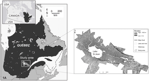
Figure 1. Location of the Saguenay-Lac-Saint-Jean region and its principal physiographic features. The delineation of the study area is based on municipal boundaries.
Developing a groundwater database was the main objective of a project conducted from 2009 to 2013 across the municipalized territory (13,210 km2) of the SLSJ region. Part of the Programme d’acquisition de connaissances sur les eaux souterraines (PACES) launched in 2008 by the Government of Quebec, Canada, the project was carried out by the Centre d’études sur les ressources minérales (CERM) of the Université du Québec à Chicoutimi (UQAC). Preliminary results of the PACES-SLSJ project were reported by Rouleau et al. (Citation2011) and the overall results were described in CERM-PACES (Citation2013).
The PACES-SLSJ project produced many collateral research projects related to aquifer characterization, groundwater quality and protection at the local and regional scale. In the SLSJ area, the wide diversity of geological units having specific hydrogeological properties is reflected by an equally diverse range of aquifer systems with contrasting characteristics. This paper presents a summary of the main results of the PACES-SLSJ project and the related research projects. Topics dealing with groundwater resources and groundwater management that require further research and application are also identified. This paper summarizes the singular aspects of the hydrogeological features of the SLSJ region, and provides an overview of the comprehensive database in a geographic information system (GIS) and a conceptual regional-scale hydrogeological model. The presented results are derived from both the bedrock units and the surficial deposits, which cover much of the lowland area of the region. Interconnections between aquifers and a synthesis of the groundwater quality in the region are also highlighted. The discussion focuses on recommendations that have emerged from the PACES-SLSJ project that aim to enhance regional hydrogeological knowledge and to improve the sustainable management of groundwater resources. As with other PACES projects (MDDELCC Citation2017b), the comprehensive database and all deliverables of the PACES-SLSJ project have been transferred to the Quebec Ministry of Sustainable Development, Environment and the Fight against Climate Change (Ministère du Développement durable, de l’Environnement et de la Lutte contre les changements climatiques [MDDELCC]) and to regional partners.
Methodology
The PACES-SLSJ project included three phases: (1) collection and digitization of existing data; (2) field work and data acquisition; and (3) synthesis of the results in the form of a numerical geodatabase, 38 regional-scale maps and a final scientific report. The project lasted four years (2009–2013).
The initial phase led to the compilation and digitization of existing data from 1200 borehole logs, 261 hydrochemical analyses, 548 grading curves, 63 piezometric maps, 11 geophysical surveys, 39 direct-push stratigraphic soundings, 74 permeability tests, 171 pumping tests and 50 stratigraphic cross sections.
Numerous approaches were used for the project’s second phase (CERM-PACES Citation2013). Using various geophysical techniques, 31,701 m was surveyed using ground-penetrating radar, 7565 m was surveyed using the time domain electromagnetic technique (TDEM) and 1750 m was surveyed using the resistivity technique. A detailed survey and analysis of fractures were conducted over a selected area that presented a high density of crystalline rock outcrops (n = 224) in the centre of the SLSJ region. Geophysical logging (caliper, fluid temperature, rock and fluid resistivity, gamma radiation, acoustic televiewer) was conducted in 12 boreholes. A total of 345 stratigraphic profiles were mapped in gravel pits or along river banks. At 30 locations, direct-push stratigraphic sounding of surficial deposits was carried out to a maximum depth of 40 m. Piezometers (1” diameter) were installed at 10 of these locations. Destructive drilling carried out in five other locations led to the installation of 13 more piezometers (2–6” diameter). Short-duration permeability tests were conducted at 165 boreholes pumped for groundwater sampling. A total of 161 groundwater samples were collected from fractured-rock aquifers and 193 samples were collected from granular aquifers, mostly private wells; the samples were analyzed for 40 hydrogeochemical parameters.
A GIS-based comprehensive database was created. It includes all previously existing data and all data acquired by the PACES-SLSJ project. All data were then interpreted to address specific research questions and to produce PACES-SLSJ deliverables. The major findings of the project are presented in this paper.
Geographic information system database
A major output of the PACES-SLSJ project was the development of a comprehensive groundwater database generated through (1) the gathering of relevant sources of information related to groundwater, and (2) the application of a quality control process to screen the data for accuracy and quality (Chesnaux et al. Citation2011a). This hydrogeological database was implemented within a GIS framework coupled to a relational database management system (RDBMS) as a file geodatabase using GIS (Esri format) technology (Chesnaux et al. Citation2011a). Stratigraphic data stored within the spatial database were used for constructing three-dimensional (3D) subsurface hydro-structural models that supported the elaboration of many PACES project deliverables and provided a sound basis for a variety of subregional, geology-related projects (e.g. Chesnaux Citation2013; Chesnaux et al. Citation2017; Foulon et al. Citation2016; Hudon-Gagnon et al. Citation2015; Richard et al. Citation2016a; Rouleau et al. Citation2011).
The SLSJ hydrogeological framework
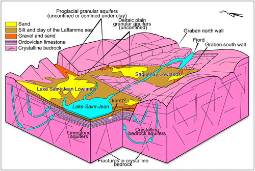
Another significant output of the PACES-SLSJ project was the creation of a schematic conceptual model of the main hydrogeological systems present in the SLSJ region (Figure ). This model was derived from existing data that were integrated during the first year of the project. Regional physiography is strongly influenced by the Saguenay Graben that has protected parts of the Paleozoic sedimentary rock units from erosion and has controlled the formation of major granular deposits in the lowland areas. Aquifer systems in the SLSJ region are composed of geological units and structures ranging from Proterozoic to Quaternary in age (Rouleau et al. Citation2015). These include: (1) a Precambrian crystalline basement belonging to the Grenville Province; (2) the Saguenay Graben, a significant topographic E–W trending depression; (3) remnants of Ordovician sedimentary cover located in the lowlands; (4) Holocene glacial and proglacial deposits; and (5) marine, littoral and deltaic sediments related to the Laflamme Sea that inundated the lowlands at the end of the last glaciation, between 11,000 and 7000 years BP. Regional geomorphology and the graben (Figure ) structure a drainage system from the highlands located to the north and south, toward the central surface water bodies and the surrounding lowlands, which include Lake Saint-Jean and the Saguenay plains, the main inhabited parts of the region. From a conceptual point of view, groundwater in the highlands infiltrates into a network of interconnected fractures and faults within the igneous and metamorphic rocks. In the lowlands, the groundwater discharges and flows dominantly into the permeable sediments. Lake Saint-Jean and the Saguenay River are the primary terminal discharge zones of the two regional groundwater flow systems (Figure ).
Figure 2. Schematic block diagram of aquifer types identified in the Saguenay-Lac-Saint-Jean region (CERM-PACES Citation2013).
Bedrock aquifers
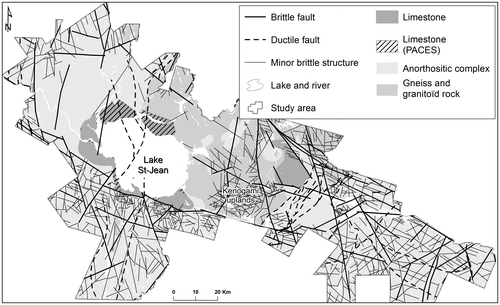
Fractured-rock aquifers are mostly present within the crystalline Precambrian basement and the Ordovician sedimentary rock units (Figure ), and are detailed below.
Figure 3. Bedrock geology of the Saguenay-Lac-Saint-Jean region, showing important structural features (brittle and ductile main structures), as the major faults delimiting the graben and the local uplands within the graben.
Precambrian rocks
As outlined by Rouleau et al. (Citation2013), the Grenville Province (Davidson Citation1998; Hocq Citation1994; Rivers et al. Citation1989) is the latest Precambrian geological province accreted to the south-eastern portion of the Canadian Shield. In the SLSJ region, rock units are mostly composed of amphibolite to granulite gneissic rocks intruded by AMCG (anorthosite, mangerite, charnockite, granite) suites of plutonic rocks. The Lac Saint-Jean Anorthosite is the major mafic intrusion present in the area.
Large amounts of oxide minerals such as magnetite and ilmenite are present in the Grenvillian bedrock, especially in association with gabbroic phases. These minerals are also present in the Quaternary units deposited downstream by the ice sheet. The presence of magnetite can interfere with the use of magnetic resonance sounding (MRS), an approach that has a proven track record in hydrogeology (Legchenko et al. Citation2002; Roy and Lubczynski Citation2003). MRS is very efficient in supplying highly relevant information related to the storage and flow properties of geological formations. As described by Roy et al. (Citation2008, 2011a) and Menier et al. (Citation2009), the wide distribution of magnetite constitutes a challenge when using the MRS technique in the Grenville Province.
Ordovician sedimentary rock units
Large remnants of mid-Ordovician sedimentary rock units, comprised of limestone and shale, unconformably overlie the Precambrian bedrock. Two of these units are recognized: the 100 km2 Saint-Honoré and the 400 km2 Lac-Saint-Jean remnants. These units form a series of stratified sedimentary rocks, including siliciclastic strata, micritic limestones and highly fossiliferous alternating limestones and shales (Desbiens and Lespérance Citation1989). In the Saguenay area, the Ordovician sequence has a maximum thickness of 110 m in PACES-SLSJ boreholes (CERM-PACES Citation2013). These boreholes also revealed the presence of shale and limestone covered in places by 60 m of overburden. These new data double the known surface area of the Lac Saint-Jean remnant currently found on regional geological maps (Avramtchev Citation1993) that cover the areas to the north of Lake Saint-Jean (Figure ). The calcareous units constitute an important exploitable aquifer, at least locally where karstic structures are observed, making this groundwater very vulnerable to contamination. However, results from a few hydraulic tests in Ordovician limestone aquifers (presumably in non-karstic zones) indicate only a slightly higher average transmissivity value (9.5 × 10⁻⁵ m2/s) than that of Precambrian rocks (4.3 × 10⁻⁵ m2/s; Richard et al. Citation2011a, 2011b).
Fault and fracture networks within the bedrock
Crystalline rocks are usually marked by a low matrix permeability; however, the locally well-developed fracture systems in the SLSJ region (Rouleau et al. Citation2013) present higher flow property values. The fault and fracture pattern shown in Figure is interpreted from existing geological maps (Hébert and Lacoste Citation1995) and is mostly related to the formation of the graben. The main brittle fracture set in the region trends WNW–ESE; this set delineates the highlands to the north and south starting from the central lowlands. A second NNW–SSE fracture set is also recognized.
The Grenvillian deformation is responsible for ductile NE trending shear zones and dominant rock fabrics (Hébert and Lacoste Citation1995) within the area. This dominant structural trend was reactivated locally during later brittle events and generated a strong anisotropic behaviour that influences underground water flow paths. The NE trending Saint-Fulgence deformation zone is a good example of this highly anisotropic area.
Brittle structures, such as faults and joints, increase the aquifer potential of the bedrock across the region. This factor was assessed in a structural hydrogeology study conducted in the Kenogami Uplands. These uplands offer a high density of outcrops, mostly constituted of anorthosite. This structure separates the Lake Saint-Jean Lowlands to the west from the Saguenay Lowlands to the east (Pino Citation2012; Pino et al. Citation2011). The orientations of both main subvertical fracture sets identified in this outcrop-scale study are similar to the brittle fractures identified at the above-mentioned regional scale. The general trend of these fractures (NW–SE) is approximately normal to the major compressional component (σ1, oriented NE) of the current regional stress field in eastern Canada, based on the literature review by Pino (Citation2012). This factor may imply that the fractures of the two main sets would tend to close and be poorer water conductors due to the action of the current stress field, while the fractures of secondary sets, including a subhorizontal set, would tend to remain open. The effects of permeable structures at depth have also been demonstrated by geophysical logging in seven boreholes in the SLSJ region (Roy et al. Citation2011b). Nevertheless, a study based on piezometric data and an analytical model (Chesnaux Citation2013) suggested that groundwater recharge in the crystalline bedrock aquifer is quite low (about 3.5 mm/yr) although higher recharge values may occur locally around fault systems.
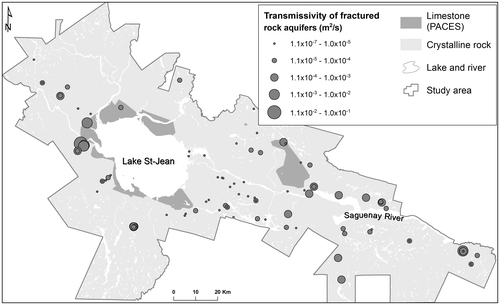
The PACES-SLSJ study showed that the mean transmissivity (T) values for the bedrock aquifers were generally low, with mean T values ranging from 3.9 × 10⁻⁵ m2/s to 9.3 × 10⁻⁵ m2/s depending on rock type (Richard et al. Citation2011a, 2011b, 2012a, 2012b, 2016a), although much higher values (up to 10−2 m2/s) have been observed (Figure ). These estimates are based on specific capacity data from 1305 wells in bedrock aquifers recorded within the Quebec hydrogeological information system (MDDELCC Citation2017c).
Figure 4. Compiled and calculated transmissivity in the fractured rock aquifers (adapted from CERM-PACES Citation2013).
Mapping of bedrock topography
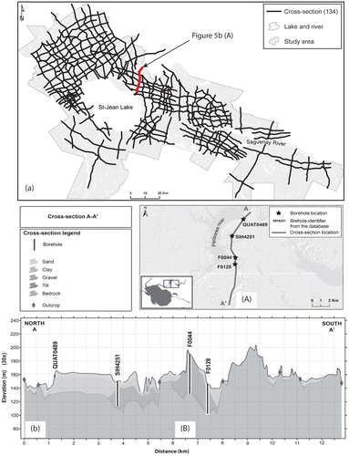
The PACES-SLSJ project produced a map of the bedrock topography over the entire territory. This map is of hydrogeological interest, particularly in areas where thick surficial deposits cover the bedrock, as it provides valuable information on the thickness of granular aquifers, and may indicate the presence of buried valleys – some perhaps previously undetected – that are now filled up by granular aquifer material. Bedrock topography and the thickness of overlying layers of surficial deposits were determined through a large number (134) of stratigraphic cross sections, distributed regularly over the territory, that were constructed from boreholes and sounding data (Figure a). An example of stratigraphic cross sections is presented in Figure b. An original approach was developed for modeling complex bedrock topography, based on virtual data points along cross sections that are added between boreholes where the stratigraphy has been observed (Chesnaux et al. Citation2017). This methodology is comprised of five steps: (1) gathering the maximum amount of relevant surface and subsurface data (from observation points); (2) determining the location of the stratigraphic sections to be constructed for interpreting bedrock topography; (3) selecting the most appropriate technique for interpolating the observed bedrock elevations that will be added into the dataset to be modeled; (4) increasing the quantity of modeling data by adding data elements based on geological interpretations of cross sections, thus creating virtual boreholes that are inserted into the model alongside the original data; and (5) 3D numerical modeling of the bedrock topography with the use of the triangulated irregular network (TIN) interpolation method. The second step is the most critical for achieving relevant results as the quality of the interpretation conducted at this stage will greatly influence the results of the interpolation of the rock topography. Many quasi-regularly distributed data points are required to ensure a reliable model of bedrock topography using interpolation methods.
Figure 5. (a) Position of the 134 cross sections developed by interpreting local stratigraphic logs from boreholes and soundings. (b) An example of cross section: (A) cross section location; (B) cross-section interpretation (Modified from Chesnaux et al. Citation2017).
Granular aquifers
Surface topography and Quaternary granular deposits
The regional physiography (Figure ) is strongly influenced by the Saguenay Graben that has controlled the emplacement and the accumulation of Quaternary deposits (sand, gravel, clay-silt), which can reach up to 180 m in thickness in the central lowlands (CERM-PACES Citation2013; Figure ), where the most populated areas are located. The map of surficial deposits is based on data from LaSalle and Tremblay (Citation1978), updated by Daigneault et al. (Citation2011).
The Quaternary granular deposits include glacial, glaciofluvial and post-glacial prograding alluvial and delta plains sediments. These sediments are deposited across the lowlands and on the bedrock uplands and plateaus. In glaciofluvial deposits, such as eskers and kames, in many places the fine particles have been washed out during the sedimentation process, resulting in permeable granular aquifers. In some locations these granular units are unconfined, whereas in other sites they are confined by extensive units of Laflamme Sea marine silt or clay. The Laflamme Sea deposited a clay-silt layer that is thickest in its central part, with sandy material around its edges. Rivers that discharged into the Laflamme Sea formed deltas and deltaic plains, which are today partly covered by more recent alluvium. These deposits are present on both sides of the graben, as rivers were then flowing both from the north and south toward the Laflamme Sea.
The deposits making up the granular aquifers present generally complex and heterogeneous internal structures due to sedimentation processes that were highly variable in space and time. The determination of hydrofacies provides a valuable approach to this complexity problem. Hydrofacies are defined as homogeneous sedimentological units, formed under characteristic conditions that lead to particular hydraulic properties (Anderson Citation1989; Klingbeil et al. Citation1999). This approach has proven relevant to the hydrogeological characterization of the Saint-Honoré granular aquifer system (Boumaiza Citation2008; Boumaiza et al. Citation2017). It was also useful for developing a conceptual hydrostratigraphic model that provided accurate numerical groundwater flow simulations over selected portions of the region (Hudon-Gagnon et al. Citation2015).
Quaternary aquifers and municipal groundwater supply
Most municipalities (about 40) in the study region that use groundwater for their drinking water supply are pumping water from wells drilled into Quaternary granular aquifers. The Quaternary units presenting the highest aquifer potential include (1) proglacial deposits left behind during the retreat of the Wisconsinan ice sheet, and (2) post-glacial deposits within deltas and deltaic plains that were formed along the coast of the Laflamme Sea. These permeable granular deposits also facilitate groundwater recharge, increasing groundwater flux within underlying bedrock aquifers; this type of indirect recharge is suggested by observed cases of interconnection between fractured bedrock and granular aquifers.
The proglacial sediments presenting the highest aquifer potential were deposited through glaciofluvial processes, forming structures such as eskers, kames and lateral moraines. Figure shows that large glaciofluvial deposits (shown in orange) are located along the normal faults delineating the graben to the north and south. In many locations, these earlier Quaternary deposits are covered by more recent layers of post-glacial marine clay-silt or sandy deltaic deposits. In Figure such superposing layers, including the areas where a glaciofluvial aquifer is confined by a clay-silt upper layer, are indicated by a hatched pattern. The presence as well as the extent of such confined aquifers is better known thanks to the creation of several stratigraphic sections (Figure ). The proglacial aquifers are characterized by T values averaging between 1.5 × 10⁻⁴ and 1.8 × 10⁻³ m2/s (Richard et al. Citation2016a), depending on test type and duration, as estimated from the results of 244 tests including data obtained prior to and during PACES.
Figure 6. Compiled and calculated transmissivity in the granular aquifers (adapted from CERM-PACES Citation2013). Main granular aquifers in the Saguenay-Lac-Saint-Jean region, forming either free-surface aquifers, shown in yellow and orange, or confined aquifers, indicated by hatching.
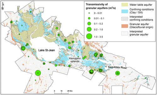
Post-glacial granular sediments constitute relatively productive unconfined aquifers. The Saint-Honoré aquifer described by Tremblay (Citation2005), Tremblay and Rouleau (Citation2004), and Boumaiza (Citation2008) is an example of a paleodeltaic aquifer that was created by a south-flowing river that discharged into the Laflamme Sea. Deltaic and shore deposits compose the major regional water table aquifers and exhibit variable T values ranging from 10−5 m2/s to 10−2 m2/s (CERM-PACES Citation2013; Chesnaux et al. Citation2011b) as represented in Figure .
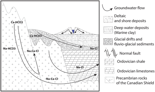
Figure 7. Generalized cross section showing the different salinization pathways occurring in the Saguenay-Lac-Saint-Jean region. Bedrock groundwater evolves from Ca,Na-HCO3 in unconfined environments to Ca,Na-Cl in rock-dominated environments due to interactions with basement fluids (water-rock interactions) along the graben fault system (groundwater flow line). The groundwater in the granular aquifers evolves from the recharge groundwater (Ca-HCO3) by Ca2+water-Na+mineral ion exchange process in a confined environment (Na-HCO3) and through possible mixing with the Laflamme seawater end-member (Na-Cl). This latter evolution might also be observed in bedrock aquifers where confining conditions prevail (Modified from Walter et al. Citation2017).
Interconnection between fractured bedrock and granular aquifers
The superposition of granular aquifers over bedrock may lead to a natural groundwater flux between aquifers and to wells pumping water simultaneously from both types of aquifer (Chesnaux and Elliott Citation2011). These two factors are often not considered in groundwater studies although they may affect significantly groundwater quality and resource assessment. Cases of hydraulic interconnection between fractured bedrock and overlying granular aquifers have been observed in numerous boreholes throughout the SLSJ region. These connections could be natural and related to the presence of fractures in the top layer of the bedrock (Chesnaux and Elliott Citation2011), or they could be due to defective borehole seals at the interface between the bedrock and the granular aquifer (Richard et al. Citation2013, 2014).
One of the bedrock sites investigated by Richard et al. (Citation2014) presented a natural hydraulic connection with the overlying granular aquifer caused by the weathered surface of the uppermost bedrock. Another site presented an artificial hydraulic connection between the bedrock and the granular aquifer created by an improperly sealed casing (Chesnaux and Richard Citation2015; Richard et al. Citation2016b). These connections present a risk of cross-contamination between aquifer units as demonstrated by Chesnaux et al. (Citation2012) who used numerical simulations motivated by PACES-SLSJ observations. Moreover, a regional analysis has shown that all types of hydraulic connections lead to erroneous interpretations of the hydraulic properties of the individual components of the aquifer system. Indeed, a significant proportion of the individual hydraulic test results are influenced by other aquifer units beyond the unit being tested, a factor generally not identified and therefore not considered in the characterization of aquifer systems. This has implications for the assessment and protection of groundwater resources, and may result in the inaccurate definition of well-capture areas and contamination risk. The hydraulic and chemical consequences of hydraulic connections were also investigated numerically by Chesnaux et al. (Citation2012).
Along the flow lines from the highlands to discharge areas, a portion of the groundwater crosses from one type of aquifer to another. This includes the transfer of groundwater from fractured bedrock to granular aquifers (Richard et al. Citation2014) during which multiple sequences of geochemical processes affect the composition, properties and quality of the groundwater.
Groundwater geochemistry
The geochemical characteristics of groundwater were investigated by analyzing 354 samples collected in the summer of 2010 and 2011, from mostly private-use water wells for single homes (CERM-PACES Citation2013; Walter et al. Citation2011, 2013, 2014). The sampled wells were uniformly distributed over the study region (Figure ). Among the samples, 161 were collected from Quaternary granular aquifers and 193 were obtained from fractured bedrock aquifers. Combining aquifer types and the two identified water types ((Na-Ca)-HCO3; (Na-Ca)-Cl) yielded four groups of samples. The number of samples considered in each group (Table ) excluded samples that failed an ionic balance validity test. At a regional scale, there was no clear association identified between the regional geology and groundwater chemistry (Walter et al. Citation2017).
Figure 8. Relative proportion of the major cations (calcium and sodium) in the collected groundwater in (a) the bedrock aquifers, and (b) the granular aquifers.
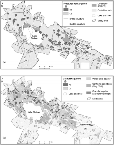
Table 1. Number of groundwater samples by aquifer type and water type.
Groundwater in the SLSJ region is generally lightly mineralized and of good quality. However, Table shows that the conductivity of water can vary from very low values (4 μS/cm) to values suggesting a brackish end-member (10,140 μS/cm). Samples having a higher conductivity mostly correspond to (Na-Ca)-Cl-type groundwater (Table ).
Table 2. Descriptive statistics for groundwater chemistry.
According to Dessureault (Citation1975), the regional marine clay aquitard is responsible for the presence of brackish groundwater in the confined Quaternary sediments. This observation was later supported by Roy et al. (Citation2011c). Walter (Citation2010) also identified brackish groundwater in the bedrock at shallow depths (<100 m), but suggested that the region’s graben morphology was responsible for the long residence time of the regional-scale flow system that converges toward Lake Saint-Jean and the Saguenay River. These observations agree with the Tóth (Citation1999) model, in which the salinity of groundwater increases with the scale of the flow system (i.e. fresh groundwater in a local-scale system, fresh to brackish in an intermediate-scale system, and brackish to brine in a regional-scale system).
Walter et al. (Citation2017) proposed two processes to explain the evolution of groundwater chemistry in the SLSJ region (Figure ): (1) evolution due to water/rock interactions, and (2) evolution of recharge groundwater due to water/clay interactions and groundwater mixing. The first process is specific to fractured-rock aquifers. Water/clay interactions account for a combination of processes, namely ion exchange and/or the leaching of saltwater trapped in the regional aquitard (Walter et al. Citation2017). Mixing with fossil seawater present in the aquifer might also increase groundwater salinity.
In some wells, the concentrations for some elements fell beyond the limits of provincial requirements (Quebec Government Citation2017) or federal guidelines (Health Canada Citation2014) on drinking water quality: fluoride (>1.5 mg/L), barium (>1 mg/L), manganese (>0.05 mg/L), iron (>0.3 mg/L) and aluminum (>0.1 mg/L) (CERM-PACES Citation2013) (Table ).
Approximately 20% of the sampled wells had groundwater fluoride levels above World Health Organization (World Health Organization Citation2004) standards (Walter et al. Citation2011; CERM-PACES Citation2013). Exposure to excessive levels of fluoride can cause fluorosis, a very dangerous and often deadly condition (Edmunds and Smedley Citation2013). In the study area, the source of fluoride has not yet been identified, but preliminary observations indicate that groundwater with a high fluoride content is collected more often in fractured-rock aquifers than in granular aquifers.
Discussion
Through the PACES program, the Government of Quebec has mandated the regional scientific community to provide scientific background data to policymakers responsible for ensuring the protection of groundwater and the sustainability of its supply (Chesnaux et al. Citation2011a). To this end, the PACES-SLSJ project has characterized the hydrogeological systems across the large, 13,210 km2 municipalized portion of the region. Multiple actions must now be taken to ensure that groundwater is truly considered in water and land management policies. Most of the points addressed in this discussion relate to the updating and transfer of knowledge from the scientists producing the data (hydrogeologists, various experts and researchers) to the various end users, including municipal policymakers, governmental agencies, watershed agencies and consultants. Achieving the full benefit of the PACES project requires action, including a continual updating of the database, an ongoing monitoring of groundwater quality, an assurance of proper protection to vulnerable aquifers, and a development of the capacity of land-use and water managers to make full use of the groundwater database.
Database updating
The PACES project in the SLSJ region has yielded a very comprehensive database detailing the regional aquifer systems and groundwater. This database is designed to answer the needs of groundwater management at the regional level. The high density of data observation points also makes the database useful for local or subregional applications. These applications may be required to address geotechnical or groundwater-related problems (Foulon et al. Citation2016), and include field activities such as borehole drilling, geotechnical sounding and geophysical surveys. The resultant data from these activities must be integrated into the database, to maintain its relevance for future use and to provide solutions to a variety of problems involving groundwater quality, its management and its protection.
Groundwater quality
The geochemical data obtained by the PACES-SLSJ project revealed that water in a significant proportion of private wells had concentrations of some elements that approached or exceeded threshold levels for drinking water quality. This was particularly true for fluoride and manganese. Moreover, resampling from selected wells has shown cases where the water content of regulated substances, such as fluoride, can fall below drinking water standards one year, then fall above drinking water standards the following year (CERM-PACES Citation2013). More extensive groundwater sampling of private wells would yield a more valid baseline of groundwater quality. This baseline could then be used in health-related studies and to identify wells that should be sampled on a regular basis to ensure a better monitoring of groundwater chemical conditions.
Groundwater protection
Some of the major aquifers composed of proglacial or glaciofluvial granular deposits are currently being pumped for private or municipal water supply. The exploitation of these aquifers for public drinking water supply indirectly provides these wells and the groundwater they produce with statutory protection against contamination (MDDELCC Citation2017a, 2017b, 2017c). However, this protection is only local, limited to the capture zones of the pumping wells. Larger portions of these granular aquifers are not contained within the capture zones of existing pumping wells and are therefore not legally protected, even in areas where the aquifer is exposed at the surface and the groundwater is deemed to be vulnerable to contamination. This lack of protection of highly valuable aquifers may jeopardize future water supplies. The database constructed by the PACES-SLSJ project represents a good starting point to define the extent of the regional aquifers that require protection even if they are not currently exploited for water supply. These groundwater reservoirs are important components of the regional natural ecosystems and are vital resources for future human generations.
Groundwater flow in a graben environment
The graben morphology controlled the incursion of the Laflamme Sea after the retreat of the Laurentide Ice Sheet. Thick accumulations of marine sediment across the lowlands act as a confining layer for some underlying aquifers. Groundwater in the southern portion of the region has a greater calcium content, while groundwater in the northern portion is dominated by sodium (Figure ). This observation is true for both fractured-rock (Figure a) and granular aquifers (Figure b). The dissolution of calcite and/or Ca-plagioclase minerals controls the chemical background of recharge groundwater in the region and explains its calcium content (Walter et al.Citation 2017). Ca2+water-Na+mineral ion exchange results in the transformation of Ca-HCO3 to Na-HCO3 due to a salinization path within the confined aquifers that are in contact with the regional aquitard and that possibly undergo groundwater mixing with the Laflamme Sea end-member (Walter et al. Citation2017). The seawater could be trapped in the regional aquitard (solute diffusion) or may be stagnant (mixing) in some portions of the aquifer (Cloutier et al. Citation2010).
Consequently, Figure suggests that in the SLSJ region, the transit time from recharge to discharge areas is shorter in the south than in the north. This suggests that the southern fault of the graben might be sufficiently permeable to allow only minor changes in the chemical content of groundwater, and might cause a rapid discharge of groundwater from the bedrock to the major proglacial aquifers located at the foot of the southern wall of the graben.
Expertise required of groundwater database users
The database developed by the PACES-SLSJ project has been transferred to the Quebec Ministère du Développement durable, de l’Environnement et de la Lutte contre les changements climatiques (MDDELCC Citation2017a) and to regional partners, as requested for all PACES projects (MDDELCC Citation2017b). The maximal exploitation of the database requires users having adequate expertise in hydrogeology and GIS. These skilled users not only will allow for the database to be fully exploited and refined, but will offer a means of training future hydrogeologists. The database not only represents a resource to be used by territorial managers and government, but also serves as an important and continually evolving link among the scientific community, government, regional and municipal authorities and, ultimately, the population that relies upon groundwater resources.
Conclusion
The complex geological history of the SLSJ region explains the spatial heterogeneity observed in the regional hydrogeology. Confined and unconfined aquifers located in both fractured-rock and Quaternary deposits combine locally to form multilayered aquifers. Glaciofluvial sediments are characterized by a transmissivity (T) of 10−4 to 10−3 m2/s and, as a consequence, are favoured as sources of municipal water supply. These reservoirs are frequently covered by a marine clay-silt aquitard, but are also occasionally unconfined at higher elevations that were not inundated by the Laflamme Sea. Deltaic and shore deposits exhibit variable T values ranging from 10−5 m2/s to 10−2 m2/s and constitute the major regional water table aquifers. Fractured-rock aquifers exhibit relatively low T values (10−6 to 10−2 m2/s). The regional-scale deformation zones can give rise to local maximum T values of 10−3 m2/s.
The chemical composition of groundwater varies markedly across the study area. Although groundwater in the SLSJ area is largely of good quality, there are areas of brackish groundwater and water containing concentrations of trace elements, such as fluoride (>1.5 mg/L), barium (>1 mg/L), manganese (>0.05 mg/L), iron (>0.3 mg/L) and aluminum (>0.1 mg/L), that are above provincial and federal drinking water quality standards.
The PACES-SLSJ project revealed the presence of a limestone unit scattered across the region that offers a new target for potential water supply. Furthermore, numerous unexplored, confined glaciofluvial aquifers were identified through the compilation and construction of stratigraphic cross sections developed in the framework of the PACES-SLSJ project. These aquifers may represent major groundwater reservoirs.
The PACES-SLSJ project highlighted the regional consequences of graben morphology for groundwater resources. The configuration of the Saguenay Graben exerted a major control over the accumulation profiles of granular deposits, thereby impacting the presence of confined and/or unconfined porous aquifers in the lowlands. These multilayered deposits may be unconnected or highly interconnected. Graben morphology is also responsible for the degradation of groundwater quality by increasing groundwater salinity along a regional-scale flow system that converges toward Lake Saint-Jean and the Saguenay River. This may also be the origin of the brackish groundwater found in some confined granular aquifers. On the other hand, in some locations of the study area, brittle structures associated with the graben are sufficiently permeable to allow only a slight modification of the chemical content of groundwater and may cause a rapid discharge of groundwater from the bedrock to the proglacial aquifers located at the foot of the graben faults in the lowlands.
The PACES-SLSJ project produced a conceptual model of regional hydrogeology. This model can serve as a solid basis for future hydrogeological investigations at a local or regional scale. Across the SLSJ region, new, relevant and accurate data (well drilling, pumping tests, groundwater quality tests, etc.) are constantly being generated by consulting firms, government agencies and others. These data should improve the accuracy of this generalized regional hydrostratigraphic model. These data must also continue to be incorporated into the regional geodatabase to ensure that this important output of the PACES-SLSJ project remains current and relevant for future projects involving regional water resources.
The results of the PACES-SLSJ project should support land-use planning efforts that consider the protection and sustainable development of groundwater resources. Much work remains to ensure a sustainable management of Quebec’s groundwater resources. The protection of water resources starts with an efficient transfer of knowledge to decision- and policymakers. This is particularly so in a context of climate change that will have a significant impact on regional hydrological systems (Trainer et al. Citation2010).
Funding
This project was made possible by financial support from the Quebec Ministère du Développement durable, de l’Environnement, de la Faune et des Parcs (MDDEFP), as well as the Conférence régionale des Élus du Saguenay-Lac-Saint-Jean (CRÉ-SLSJ), the City of Saguenay, the Pekuakamiulnuatsh band council, and the following regional county municipalities (MRC): Domaine-du-Roy, Fjord-du-Saguenay, Lac-Saint-Jean-Est and Maria-Chapdelaine. A preliminary project (2008–2009) focusing on a portrait of regional groundwater resources was financed by these same regional organizations and by the regional office of the following Quebec ministries: Ressources naturelles (MRN), Affaires municipales, des Régions et de l’Occupation du territoire (MAMROT), Agriculture, Pêcheries et Alimentation (MAPAQ), and l’Agence régionale de la Santé et des Services sociaux (ASSS).
Acknowledgements
The authors acknowledge the input of numerous collaborators (colleagues, assistants and students) during the data acquisition and analysis phases of the project. We are also grateful for the constructive comments of two anonymous reviewers.
References
- Anderson, M. P. 1989. Hydrogeological facies models to delineate large-scale spatial trends in glacial and glaciofluvial sediments. Geological Society of America Bulletin 101: 501–511.
- Avramtchev, L. 1993. Carte minérale de la région du Saguenay-Lac-Saint-Jean. Ministère de l’énergie et des ressources du Québec, 1 map. PRO9307.
- Boumaiza, L. 2008. Caractérisation hydrogéologique des hydrofaciès dans le paléodelta de la rivière Valin au Saguenay. Master’s thesis, Université du Québec à Chicoutimi.
- Boumaiza, L., A. Rouleau, and P. A. Cousineau. 2017. Determining hydrofacies in granular deposits of the Valin River paleodelta in the Saguenay region, Quebec. (In Proceedings of the 70th Canadian Geotechnical Conference and 12th Joint CGS/IAH-CNC Groundwater Conference, Ottawa, 7 pp).
- CERM-PACES. 2013. Résultats du programme d’acquisition de connaissances sur les eaux souterraines de la région Saguenay-Lac-Saint-Jean. Chicoutimi: Centre d’études sur les ressources minérales, Université du Québec à Chicoutimi, 308 pp.
- Chesnaux, R. 2013. Regional recharge assessment in the crystalline bedrock aquifer of the Kenogami uplands. Canada. Hydrogeological Sciences Journal 58 (2): 421–436.
- Chesnaux, R., and A.-P. Elliott. 2011. Demonstrating evidence of hydraulic connections between granular aquifers and fractured rock aquifers. (In Proceedings of GeoHydro 2011, Joint Meeting of the Canadian Quaternary Association and the Canadian Chapter of the International Association of Hydrogeologists, August 28–31, 2011, Quebec City, 8 pp).
- Chesnaux, R., and S. K. Richard. 2015. Consequences of a defective seal into a bedrock aquifer: field site example and numerical study. In International Association of Hydrogeologists IAH, 42nd IAH International Congress – Aqua 2015, Rome.
- Chesnaux, R., M. Lambert, J. Walter, U. Fillastre, M. B. Hay, A. Rouleau, R. Daigneault, A. Moisan, and D. Germaneau. 2011a. Building a geodatabase for mapping hydrogeological features and 3D modeling of groundwater systems: Application to the Saguenay-Lac-St-Jean Region. Canada. Computers & Geosciences 37 (11): 1870–1882.
- Chesnaux, R., C. Baudement, and M. Hay. 2011b. Assessing and comparing the hydraulic properties of granular aquifers on three different scales. (In Proceedings of GeoHydro 2011, Joint Meeting of the Canadian Quaternary Association and the Canadian Chapter of the International Association of Hydrogeologists, August 28–31, 2011, Quebec City, 8 pp).
- Chesnaux, R., S. Rafini, and A.-P. Elliott. 2012. A Numerical investigation to illustrate the consequences of hydraulic connections between granular and fractured-rock aquifers. Hydrogeology Journal 20 (8): 1669–1680.
- Chesnaux, R., M. Lambert, J. Walter, V. Dugrain, A. Rouleau, and R. Daigneault. 2017. A simplified geographical information system (GIS)-based methodology for modeling the topography of bedrock: Illustration using the Canadian Shield. Journal of Applied Geomatics 9 (1): 61–78. doi:10.1007/s12518-017-0183-1.
- Cloutier, V., R. Lefebvre, M. M. Savard, and R. Therrien. 2010. Desalination of a sedimentary rock aquifer system invaded by Pleistocene Champlain Seawater and processes controlling groundwater geochemistry. Environmental Earth Sciences 59: 977–994.
- Daigneault, R.-A., P. Cousineau, E. Leduc, G. Beaudoin, S. Millette, N. Horth, D. W. Roy, M. Lamothe, and G. Allard. 2011. Rapport final sur les travaux de cartographie des formations superficielles réalisés dans le territoire municipalisé du Saguenay-Lac-Saint-Jean. Quebec City: Ministère des Ressources naturelles et de la Faune du Québec.
- Davidson, A. 1998. An overview of Grenville Province geology. Chap. 3 in Geology of the Superior and Grenville Provinces and Precambrian Fossils in North America, ed. S. B. Lucas and M. R. St-Onge, 205–270. Geology of Canada, no.7, Geological Survey of Canada; and Geology of North America, vol. C-1, Geological Society of America.
- Desbiens, S., and P. J. Lespérance. 1989. Stratigraphy of the Ordovician of the Lac Saint-Jean and Chicoutimi outliers, Quebec. Canadian Journal of Earth Sciences 26: 1185–1202.
- Dessureault, R. 1975. Hydrogéologie du Lac Saint-Jean, partie nord-est. Québec: Ministère des richesses naturelles, Direction générale des eaux, Service des eaux souterraines.
- Edmunds, W. M., and P. L. Smedley. 2013. Fluoride in natural waters. In Essentials of Medical Geology, ed. O. Selinus, 311–336. Dordrecht, The Netherlands: Springer.
- Foulon, T., A. Saeidi, R. Chesnaux, A. Rouleau, and M. Nastev. 2016. Modélisation des dépôts meubles, un élément du risque sismique sur le territoire de la Ville de Saguenay. In GeoVancouver 2016, Proceedings of the Canadian Geotechnical Society Annual Meeting, 7
- Health Canada. 2014. Guidelines for Canadian drinking water quality: summary table. Federal–Provincial–Territorial Committee on Drinking Water. http://www.hc-sc.gc.ca/ewh-semt/pubs/water-eau/sum_guide-res_recom/index-eng.php (accessed July 2015).
- Hébert, C., and P. Lacoste. 1995. Compilation géoscientifique, géologie du Saguenay Lac Saint-Jean. Ministère des Ressources naturelles, Système d’information géominière du Québec, 8 maps. 1:50 000.
- Hocq, M. 1994. La province de Grenville. In Géologie du Québec, ed. M. Hocq, 75–94. Québec: Les Publications du Québec.
- Hudon-Gagnon, E., R. Chesnaux, P. A. Cousineau, and A. Rouleau. 2015. A hydrostratigraphic simplification approach to build 3D groundwater flow numerical models: example of a Quaternary deltaic deposit aquifer. Environmental Earth Sciences 74: 4671–4683.
- Klingbeil, R., S. Kleineidam, U. Asprion, T. Aigner, and G. Teutsch. 1999. Relating lithofaciès to hydrofacies: outcrop-based hydrogeological characterization of quaternary gravel deposits. Sedimentary Geology 129 (3–4): 299–310.
- LaSalle, P., and G. Tremblay. 1978. Dépôts meubles, Saguenay - Lac St- Jean. Ministère des Richesses naturelles du Québec, Geology Report 191, 61 pp.
- Legchenko, A., J. M. Baltassat, A. Beauce, and J. Bernard. 2002. Nuclear magnetic resonance as a geophysical tool for hydrogeologists. Journal of Applied Geophysics 50 : 21–46.
- MDDELCC. 2017a. Système d’Information Hydrogéologique. Quebec: Ministère du Développement durable, de l’Environnement et de la Lutte aux changements climatiques. http://www.mddelcc.gouv.qc.ca/eau/souterraines/sih/index.htm (Accessed September 2017).
- MDDELCC. 2017b. Programme d’acquisition de connaissances sur les eaux souterraines. Ministère du Développement durable, de l’Environnement et de la Lutte aux changements climatiques. http://www.mddelcc.gouv.qc.ca/eau/souterraines/programmes/acquisition-connaissance.htm (Accessed February 2017)
- MDDELCC. 2017c. Water Withdrawal and Protection Regulation. Ministère du Développement durable, de l’Environnement et de la Lutte aux changements climatiques. http://www.mddelcc.gouv.qc.ca/eau/prelevements/reglement-prelevement-protection/index-en.htm (Accessed February 2017)
- Menier, J., J. Roy, and A. Rouleau. 2009. Field and laboratory investigation in support of the application of the magnetic resonance sounding method in granular aquifers in the Grenville Province. (In Proceedings of the 62nd Canadian Geotechnical Conference and 10thJoint CGS/IAH-CNC Groundwater Conference, Halifax, September 20–24, 1593–1599).
- Ogunba, A. 2012. Threats to groundwater: lessons from Canada and selected jurisdictions. Journal of Energy & Natural Resources Law 30 (2): 159–184.
- Pino, D. S. 2012. Structural hydrogeology in the Kenogami uplands, Quebec, Canada. Master’s thesis, Université du Québec à Chicoutimi. http://constellation.uqac.ca/2572/
- Pino, D. S., A. Rouleau, D. W. Roy, and R. Daigneault. 2011. Analysis of the joint system in the Kenogami uplands bedrock aquifer: methodology and preliminary results. (In Proceedings of GeoHydro 2011, Joint Meeting of the Canadian Quaternary Association and the Canadian Chapter of the International Association of Hydrogeologists, August 28–31, 2011, Quebec City).
- Quebec Government. 2017. Regulation respecting the quality of drinking water. Environment Quality Act, Chapter Q-2, r. 40. http://legisquebec.gouv.qc.ca/en/ShowDoc/cr/Q-2,%20r.%2040 (accessed October 2017)
- Richard, S. K., R. Chesnaux, and A. Rouleau. 2011a. Estimating the hydraulic properties of aquifers from specific capacity data: Saguenay-Lac-Saint-Jean, Quebec. (In Proceedings of GeoHydro 2011, Joint Meeting of the Canadian Quaternary Association and the Canadian Chapter of the International Association of Hydrogeologists, August 28–31, 2011, Quebec City, 8 pp).
- Richard, S. K., R. Chesnaux, and A. Rouleau. 2011b. Evaluación de la transmisividad a partir del caudal específico enlos acuiferos de la región de Saguenay-Lac-St-Jean, Québec, Canada. (In Proceedings of VII Congreso Argentino de Hidrogeología, October 18–21 2011, Salta, Argentina, 8 pp).
- Richard, S. K., R. Chesnaux, and A. Rouleau. 2012a. From calculating transmissivity to understanding its origin in the fractured-rock aquifers. (In Proceedings of International Conference on Groundwater in Fractured Rocks, May 21–24, 2012, Prague, Czech Republic).
- Richard, S. K., R. Chesnaux, and A. Rouleau. 2012b. Hydraulic factors controlling groundwater flow in the fractured rock aquifers of the Saguenay-Lac-Saint-Jean region, Quebec, Canada. (In 39th IAH International Conference, September 17–21, 2012, Niagara Falls, Canada).
- Richard, S. K., R. Chesnaux, and A. Rouleau. 2013. Detecting preferential seepage along casing installed in fractured rock aquifers: Examples from the Saguenay-Lac-Saint-Jean region, Canada. (In GeoMontreal 2013, the 66th Canadian Geotechnical Conference and the 11th Joint CGS/IAH-CNC Groundwater Conference, September 29–October 3, 2013, Montreal, Quebec)
- Richard, S. K., R. Chesnaux, A. Rouleau, R. Morin, J. Walter, and S. Rafini. 2014. Field evidence of hydraulic connections between bedrock aquifers and overlying granular aquifers: examples from the Grenville Province of the Canadian Shield. Hydrogeology Journal 22 (8): 1889–1904.
- Richard, S. K., R. Chesnaux, A. Rouleau, and R. H. Coupe. 2016a. Estimating the reliability of aquifer transmissivity values obtained from specific capacity tests: examples from the Saguenay-Lac-Saint-Jean aquifers, Canada. Hydrological Sciences Journal 61 (1): 173–185.
- Richard, S. K., R. Chesnaux, and A. Rouleau. 2016b. Detecting a defective casing seal at the top of a bedrock aquifer. Groundwater 54 (2): 296–303.
- Rivers, T., J. Martignole, C. F. Gower, and T. Davidson. 1989. New tectonic divisions for the Grenville province, southeast Canadian Shield. Tectonics 8 : 63–84.
- Rouleau, A., J. Walter, R. Daigneault, D. Germaneau, D. W. Roy, M. Lambert, R. Chesnaux, A. Moisan, and D. Noël. 2011. La diversité hydrogéologique du territoire du Saguenay-Lac-Saint-Jean (Québec). (In Proceedings of GeoHydro 2011, Joint Meeting of the Canadian Quaternary Association and the Canadian Chapter of the International Association of Hydrogeologists, August 28–31, 2011, Quebec City).
- Rouleau, A., I. D. Clark, D. J. Bottomley, and D. W. Roy. 2013. Precambrian Shield. Chap 11 in Canada`s Groundwater Resources, edited by A. Rivera, 415–442. Markham: Fitzhenry & Whiteside.
- Rouleau, A., J. Walter, R. Chesnaux, V. Cloutier, and I. D. Clark. 2015. An overview of the hydrogeology of the Canadian Shield with emphasis on the Saguenay-Lac-St-Jean area. (In Vingtième journée du comité français d’hydrogéologie de l’association international des hydrogéologues, “Aquifères de socle: le point sur les concepts et les applications opérationnelles,” La Roche-sur-Yon, France, June 11–13, 2015).
- Roy, J., and M. Lubczynski. 2003. The magnetic resonance sounding technique and its use for groundwater investigations. Hydrogeology Journal 11 : 455–465.
- Roy, J., A. Rouleau, M. Chouteau, and M. Bureau. 2008. Widespread occurrence of aquifers currently undetectable with the MRS technique in the Grenville geological Province. Canada. Journal of Applied Geophysics 66 (3–4): 82–93.
- Roy, J., A. Legchenko, A. Rouleau, M. Bureau, M. Chouteau, J. Menier, Y. Leblanc, D. Richard, E. Gloaguen, and Y. Benhouhou. 2011a. In-situ 1H NMR to map groundwater non-invasively: problems and prospects in the Grenville. (In Proceedings of GeoHydro 2011, Joint Meeting of the Canadian Quaternary Association and the Canadian Chapter of the International Association of Hydrogeologists, August 28–31, 2011, Quebec City).
- Roy, J., R. Morin, R. Chesnaux, S. Richard, D. Pino, A. Rouleau, D. W. Roy, J. Walter, and D. Noël. 2011b. Hydrogeological insight from geophysical water-well logging in hard rocks in the Saguenay region, Québec. (In Proceedings of GeoHydro 2011, Joint Meeting of the Canadian Quaternary Association and the Canadian Chapter of the International Association of Hydrogeologists, August 28–31, 2011, Quebec City).
- Roy, D.W., G. Beaudoin, E. Leduc, A. Rouleau, J. Walter, R. Chesnaux, and P. A. Cousineau. 2011c. Post glacial differential isostasy in the Lac-St.-Jean area (Quebec, Canada) and implications for the quality of groundwater. (In Proceedings of GeoHydro 2011, Joint Meeting of the Canadian Quaternary Association and the Canadian Chapter of the International Association of Hydrogeologists, August 28–31, 2011, Quebec City, 8 pp).
- Tóth, J. 1999. Groundwater as a geologic agent: An overview of the causes, processes, and manifestations. Hydrogeology Journal 7 (1): 1–14.
- Trainer, M. A., P. Baveye, and G. Syme. 2010. Goals, gaps and governance: The holy grail in preserving Canada’s hidden liquid gold. Journal of Hydrology 380 (1): 1–3.
- Tremblay, P. 2005. Étude hydrogéologique de l’aquifère de Saint-Honoré avec emphase sur son bilan hydrique. Master’s thesis, Université du Québec à Chicoutimi, Chicoutimi.
- Tremblay, P., and A. Rouleau. 2004. Water budget analysis of the paleo-deltaic Saint-Honoré aquifer in the Saguenay lowlands. (In Proceedings of the Fifth Joint Annual Conference, Canadian Geotechnical Society & Canadian Chapter of the International Association of Hydrogeologists, Québec, Québec, October 23–27, 2004, 8 pp).
- Walter, J. 2010. Les eaux souterraines à salinité élevée autour du lac Saint-Jean, Québec: origines et incidences. Master’s thesis, Université du Québec à Chicoutimi, Chicoutimi.
- Walter, J., A. Rouleau, D. W. Roy, and R. Daigneault. 2011. Hydrogéochimie des eaux souterraines de la région du Saguenay-Lac-Saint-Jean: résultats préliminaires. (In Proceedings of GeoHydro 2011, Joint Meeting of the Canadian Quaternary Association and the Canadian Chapter of the International Association of Hydrogeologists, August 28–31, 2011, Quebec City, 6 pp).
- Walter, J., A. Rouleau, and R. Chesnaux. 2013. Regional assessment of composite groundwater parameters, illustrated by the Saguenay-Lac-Saint-Jean region, including methods and limitations. (In GeoMontreal 2013, the 66th Canadian Geotechnical Conference and the 11th Joint CGS/IAH-CNC Groundwater Conference, September 29–October 3, 2013, Montreal, Quebec, Canada).
- Walter, J., R. Chesnaux, D. Gaboury, and V. Cloutier. 2014. Multivariate analysis of hydrochemical data to assess the geochemical processes controlling the groundwater geochemistry of the Saguenay-Lac-St-Jean region, Quebec, Canada. (In International Association of Hydrogeologists IAH, the Moroccan Chapter, 41st IAH International Congress “Groundwater: Challenges and Strategies”, Marrakech, September, 15–19, 2014).
- Walter, J., R. Chesnaux, V. Cloutier, and D. Gaboury. 2017. The influence of water/rock − water/clay interactions and mixing in the salinization processes of groundwater. Journal of Hydrology: Regional Studies 13 (2017): 168–188.
- World Health Organization. 2004. Guidelines for drinking-water quality: recommendations, (Vol. 1). World Health Organization. http://www.who.int/water_sanitation_health/publications/gdwq3rev/en/ (accessed October 2017).