
Abstract
Ontario urban development necessitates stream restoration projects for existing watercourses that flow through a property under development. This is part of the planning process, mandated by local conservation authorities to conserve the natural heritage and ecological function of natural areas identified under Ontario’s Ecological Land Classification. Stream restoration is commonly incorporated into larger stormwater management upgrades in the re-developed landscape. This study evaluates flow attenuation and water quality mitigation of a pocket wetland (PW), a shallow constructed wetland located at the outlet of a stormwater management system, within a major channel realignment and stream restoration project in Brampton, Ontario, Canada. The PW was incorporated into the floodplain of the natural channel design, between the outflow of the stormwater pond and a tributary of Churchville Creek. The latter contains habitat for redside dace (Clinostomus elongates), a designated species-at-risk under the Ontario Endangered Species Act. The addition of the PW to the stormwater treatment train was designed to mitigate the impacts that poor water quality has on local biota. Runoff, water temperature, total suspended solids and conductivity were monitored during 21 rainfall events between May and October 2014. Average PW event residence time was ~2 h and the overall changes in water quality between instream monitoring sites were negligible. Instream water temperature changes were minor (< 1°C) during flow events, with small increases in water temperature (< 0.5°C) observed during baseflow. The change in suspended sediment between the stream and PW flow was −22–31 mg/L. Suspended sediment inputs were greatest in the fall, which coincides with larger rainfall events. This study demonstrates PWs provide additional water storage time, and have added value in stormwater management. Although PWs are not formally included in current policy requirements, evidence from this study suggests the inclusion of PWs in future projects is worthwhile.
Le développement urbain nécessite souvent des projets de restauration des risseaux et cela est communément incorporé dans les initiatives d’améliorations de gestion des eaux pluviales dans le paysage re-développé. Cette étude a évalué l’efficacité à valeur ajoutée d’une marais construite (MC) intégrée à la fin d’un système de gestion des eaux pluviales dans un projet de realignment des canaux et restauration des ruisseaux à Brampton, Ontario, Canada. Le marais construite était situé entre les sorties de fonds de l’étang d’eaux pluviales et un affluent du ruisseau Churchville, un habitat important pour le méné long (Clinostumus elongatus), une espèce en péril désignée. Décharge, température de l’eau, et les charges dissoutes et suspendues ont été surveillé pendant 21 événements de pluies entre mai et octobre 2014. Temps de résidence moyen d’événement dans le MC était environ 2 heures et les changements globaux dans la qualité de l’eau entre les sites de surveillance dans le ruisseau étaient négligeables. Ruisseau changements de la temperature de l’eau étaient mineurs (moins de 1°C) pendant les événements de débit, avec petites augmentations (moins de 0,5°C) observés pendant du débit de base. Le changement dans les sédiments en suspension entre le flux du ruisseau et le flux de la MC était entre 22 et 31 mg/L. Les apports des sediments en suspension étaient plus grands à l’automne, coïncidant avec les plus grandes événements de pluies. Cette étude démontre que les MCs offrent de temps additionel de la stockage d’eau et ont une valeur ajoutée dans la gestion des eaux pluviales. Bien que les MCs ne sont pas officiellement inclus dans les exigences de la politique actuelle, l’évidence de cette étude suggère que l’inclusion des MCs dans les projets en future pourrait se révéler utile.
Introduction
Urban areas are expanding into former agricultural or forested regions and this new development alters the landscape’s hydrological response to rainfall, requiring stormwater management (SWM) systems (Paul and Meyer Citation2001; Konrad and Booth Citation2005; Booth and Bledsoe Citation2009; Brabec Citation2009; Brown et al. Citation2009). Without SWM systems, increased overland flow, due to reduced infiltration, leads to flooding, and poor water quality in adjacent streams and ponds (Arnold Jr. and Gibbons Citation1996; Sansalone and Cristina Citation2004; Konrad and Booth Citation2005; Lawler et al. Citation2006; Booth and Bledsoe Citation2009; Brabec Citation2009). In addition, there is a loss in habitat for local species, as their specific preferences for water temperature, turbidity and chemical balance are put at further risk (Novinger and Coon Citation2000; Stanfield and Kilgour Citation2006; Stanfield and Jackson, Citation2011). Multiple streams in Southern Ontario are identified habitat for endangered redside dace (Clinostomus elongates), and the preservation of habitat for this species is mandated under the Ontario Endangered Species Act (Endangered Species Act, SO Citation2007; c 6, s 7). Several studies demonstrate that impervious surfaces associated with development accumulate particulates, which are easily washed into local streams during rainfall runoff events (Arnold Jr and Gibbons Citation1996; Paul and Meyer Citation2001; Sansalone and Cristina Citation2004). Furthermore, asphalt and other surfaces typical of development are warmed by solar radiation and subsequently warm overland flows (Poole and Berman Citation2001; Bradford and Gharabaghi Citation2004). Studies suggest impervious surface area as low as 10% of the total watershed may result in observable water quality degradation while 20% will result in hydrological changes (Paul and Meyer Citation2001; Bradford and Gharabaghi Citation2004; Brabec Citation2009; Eimers and McDonald Citation2014).
SWM systems are used to mitigate the effects of urban development on local water systems (Pitt Citation1999; Bradford and Gharabaghi Citation2004; Shutes et al. Citation2005; Scholes et al. Citation2008; Pyke et al. Citation2011; Hunt et al. Citation2012; Malaviya and Singh Citation2012). Low-impact development (LID) systems attenuate peak runoff and remediate stormwater quality onsite, while maintaining aesthetics (e.g. rain gardens). Wetlands, bioretention systems, permeable pavements and vegetated swales are commonly used LID features (Arnold Jr. and Gibbons Citation1996; Booth and Bledsoe Citation2009). Stormwater ponds (SWPs) are an SWM feature used to detain flow from large storm events and provide space for sediment and pollutants to settle (Booth and Bledsoe Citation2009). SWPs are most effective at detaining water and trapping smaller sized sediments and pollutants, which impact downstream aquatic ecology. Bioretention systems are constructed for the infiltration of surface runoff through engineered media responsible for the removal of metals, fine-grained sediment, organics and high concentrations of chemicals (phosphorus, nitrogen) (Endreny and Collins Citation2009; Li and Davis Citation2009; Roy-Poirier et al. Citation2010). Bioretention systems are also effective at controlling small-magnitude storm events that occur more frequently, detaining most of the water, which would otherwise contribute to immediate surface flow (Pitt Citation1999; Burns et al. Citation2012).
A pocket wetland (PW) is an end-of-pipe LID practice that provides additional water detention between the outlet of an SWP and the adjacent stream. The PW is a constructed wetland located at the outlet of the SWP (Figure ). The PW infiltration system disperses flow from the SWP over a vegetated surface, allowing water to infiltrate into the media (Li and Davis Citation2009; Roy-Poirier et al. Citation2010; Wadzuk et al. Citation2010; Davis et al. Citation2012; Hunt et al. Citation2012; Malaviya and Singh Citation2012). A PW will detain moderate to intermediate rainfall events, providing infiltration into subsurface media before entering the stream, while heavy events may pass as surface flow as the PW becomes saturated (Hunt et al. Citation2012). The longer it takes stormwater runoff to move through a PW, the greater the potential residence time and water quality benefits. The extended flow path from the SWP through the PW allows for additional sedimentation, and filtration of stormwater, while the vegetation provides shade to limit increases in water temperature (Li and Davis Citation2009; Davis et al. Citation2012; Hunt et al. Citation2012). Sedimentation of the largest particles occurs as the surface flow passes through the vegetated wetland. Subsurface flow through the underlying media filters the finer particles, while media pore space stores water, which is then released slowly into the stream and augments baseflow conditions. Filtration of stormwater through the media also promotes the sequestration of bacteria and chemical sorption of metals, phosphorus and nitrogen (Li and Davis Citation2009; Hunt et al. Citation2012).
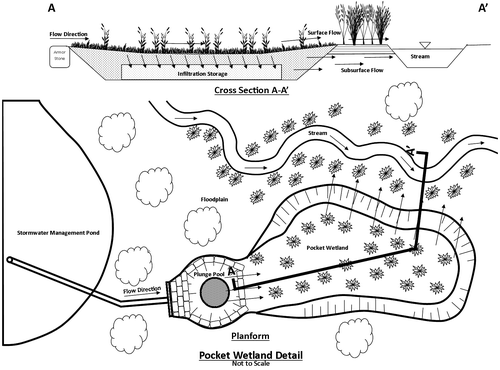
Figure 1. An illustration of a pocket wetland (PW) and the intended flow paths. It is a small constructed wetland located at the outfall of a stormwater management pond. The intent of this design is to intercept stormwater, providing additional flow attenuation and mitigation of poor water quality associated with residential neighborhoods. The PW is heavily vegetated and has a porous storage medium to promote storage of small runoff events and groundwater inputs to the adjacent stream. Larger runoff events may flow through as surface runoff. The PW is designed to promote cooling, aggradation and sedimentation to improve effluent water temperature, total suspended solids (TSS) and total dissolved solids (TDS).
It is common for SWM systems to include multiple approaches in series, creating a ‘treatment train’ of infrastructure (Bradford and Gharabaghi Citation2004; Shutes et al. Citation2005; Scholes et al. Citation2008). Stormwater treatment trains increase the flow path length for stormwater runoff attenuation and may improve water quality through multiple SWM and LID systems. SWM systems are designed to attenuate rain-induced runoff and provide adequate residence time to mitigate the impacts of increased water temperature, total suspended solids (TSS) and total dissolved solids (TDS) on local streams. Recent management practices in Ontario include stormwater treatment trains with end-of-pipe treatment at an SWP outlet (Bradford and Gharabaghi Citation2004; Hunt et al. Citation2012; Malaviya and Singh Citation2012); however, few studies have evaluated the effectiveness of PW. The working hypothesis is that the PW at the final stage in the stormwater treatment train will attenuate flow and mitigate impacts on temperature, TSS and conductivity from the overall stormwater management system in the Churchville Watershed. Most importantly, its inclusion does not adversely impact water quality and provides additional residence time to effectively lengthen the runoff path of the stormwater treatment train to a receiving stream. The case study presented here serves as a proof-of-concept for PW following a watercourse realignment and restoration project. In this study various flow and water quality parameters were monitored through 21 rainfall events in 2014 to test the impact of the PW system. With the results from these events, residence time of water within the PW was estimated, and wetland efficiency at moderating the quality of water leaving the SWP and entering the adjacent stream was predicted.
Methods
Study system
A major stream realignment and SWM project began in 2010 to address land-use conversion from agricultural fields to residential and light commercial land use northwest of Chinguacousy Rd. and Queen St. W, in Brampton, Ontario (Figure ; 43°39’49”N, 79°47’07”W). Churchville Creek was identified as habitat for redside dace, and protected under the Ontario Endangered Species Act (Endangered Species Act, SO, Citation2007; c 6, s 7). A novel aspect of this SWM and watercourse restoration project was to incorporate PWs into the floodplain as a final step in the stormwater treatment train as Churchville Creek was the subject of restoration work to provide habitat for redside dace (Credit Valley Conservation Authority Citation2004). The catchment contains SWM systems conveying stormwater runoff through subsurface conduits into a stormwater pond before entering the stream. The areas connected directly to the stream without SWM are the remaining forested areas and the restored stream corridor (Figure ). The stream is ~3 m wide, with bankfull depths ranging from 0.3 to 0.6 m. During the 2014 study period there was ongoing construction that modified flow in the channel upstream of the PW.
Figure 2. The Churchville pocket wetland (PW) is located north of the intersection of James Potter Rd. and Queen Street West (43°39’49”N, 79°47’07”W) in Brampton, ON, Canada (inset). Runoff from the stormwater catchment (~0.15 km2) drains through conduits into the stormwater pond, and then flows through the PW (~900 m2) before entering Churchville Creek.
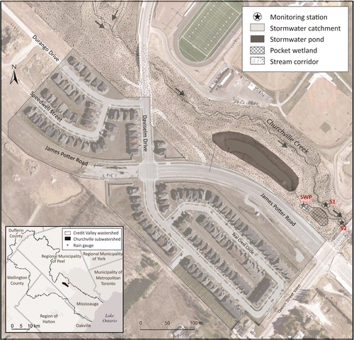
The PW is the last stop for runoff from a mostly residential area (~0.15 km2) including ~1.8 km of road network (Figure ). The runoff enters a conveyance system beneath the road network, which enters the SWP and then the PW before entering Churchville Creek, a tributary of the Credit River (Figure ). All of the runoff from the residential study catchment flows through the treatment train (SWP and PW) before entering the stream. The SWP has a 3-m permanent water depth, which covers ~0.028 km2, while the 5-m maximum water level covers ~0.093 km2 due to the pond’s sloped sides. The PW is a vegetated area (Table ; ~900 m2) allowing SWP outflow to infiltrate into the underlying storage media (0.30 m topsoil and 0.30 rip-rap stone and topsoil mix). An incised channel (~0.20 m wide, ~0.15 m deep) connects the PW with the stream; this was not part of the initial PW design and developed naturally after initial construction. Standing surface water (average depth ~0.15 m) remained within the PW, suggesting the subsurface media remained saturated. Overland flow increased during rainfall events as the surface water breached the PW edges and drained directly into Churchville Creek. The total Churchville sub-catchment area upstream of the study site is roughly 294 km2.
Table 1. Wet meadow seed mix installed in the Churchville pocket wetland (PW).
Data collection and processing
Rainfall data was recorded at 5-min intervals by a tipping-bucket rain gauge operated by the Region of Peel, ~2 km northeast of the study site (Figure ). Stream gauging cross-sections and monitoring points were located in Churchville Creek, upstream (S1) and downstream (S2) of the PW and at the stormwater pond outlet (SWP). Onset HOBO water-level loggers (range: 0–9 m; accuracy: ± 0.005 m) and conductivity sensors (range: 0–1000 μS/cm; accuracy: 5 μS/cm) measured and recorded water level and electrical conductivity (EC), respectively, at 5-min intervals at all three locations. As well, both sensors included thermocouples that measured water temperature (range: −−20 to +50°C; accuracy: ± 0.44°C). A fourth logger was used to measure air temperature and atmospheric pressure (accuracy: ± 0.05 kPa). Stilling wells housed water-level loggers within the stream (~0.02 m from streambed). EC sensors were installed in Polyvinyl chloride pipe housing and attached to the stilling wells 0.05 m from the channel bottom. A Marsh–McBirney Flow-Mate 2000 (range: −−0.15–6 m/s; accuracy: ± 2%) was used to manually measure velocity at cross sections in the channel (S1 and S2 locations) to calculate stream discharge. Discharge at SWP was estimated by measuring the time that lapsed while filling a 40-L container.
Site maintenance, stream gauging and TSS sample collection were conducted on a weekly basis. A DH48 depth-integrating sampler was used to collect ~250-mL water samples for TSS. TSS samples were filtered through pre-weighed polycarbonate 0.4-μm filters, dried at 50°C overnight and re-weighed to determine TSS. Additional site visits occurred during rainfall events to conduct additional gauging and sample collection. ISCO portable pump-samplers enabled TSS monitoring for two storm events over a 24-h period, collecting 500-mL water samples at S1 and S2 every hour. Although the pump-samplers were sent out multiple times, there were several instances where one sampler would fail and thus a comparison between S1 and S2 was not possible.
Water level, temperature and conductivity data were processed to determine quantity and quality of influent and effluent flow from the PW. The quantity and quality of effluent flow conditions from the PW were determined by subtracting variables at S1 from S2, as the output from the PW is dynamic and unconstrained to one location. Water-level loggers measured total pressure and were converted to stage measurements by subtracting atmospheric pressure from total pressure. Continuous discharge was assessed using a stage-discharge rating curve for each monitoring location. To compare the discharge measurements to rainfall at SWP and the S1/S2 monitoring locations, values were calibrated from cubic meters per second (m3/s) to millimeters (mm) of total runoff using the study site catchment area and total upstream catchment areas, respectively.
Event analysis defined 21 rainfall events and corresponding runoff ratio coefficients. A straight-line hydrograph separation technique was used to define each event from baseflow conditions. Antecedence was calculated as total rainfall over 5 days before the event. EC was converted to TDS following published conversions (Walton Citation1989; Atekwana et al. Citation2004; Pellerin and Wollheim Citation2008; Marandi et al. Citation2013). A t-distribution (α = 0.05) difference-of-means test determined significant changes in temperature, TDS and TSS conditions at S1 and S2. An EC concentration traced the ‘first flush’ through rainfall events and was used as an estimate for the PW residence time.
During the field season there was active construction upstream of the study area 27 June–8 September, and at various times during the season construction disrupted the water quality monitoring efforts. The PW system was also altered (and instruments were destroyed) when a concrete orifice plate, located at SWP, was removed and thus changed the influent runoff conditions to the PW. This alteration to the outlet structure was unforeseen during the period of data collection and though the intent of this structure may have been temporary, there was no rationale for the orifice plate removal. To account for the alteration to the SWM outlet at SWP, water quantity was determined with a straight-line delineation and the data were separated into two periods for analysis. The water quality results presented in this study from before 27 June reflect the period when the orifice plate was in place, and results after 8 September have no orifice plate.
Results
Rainfall and runoff events
There were 21 rainfall runoff response events evaluated during the field season, as determined by straight-line hydrograph separation when recorded rainfall coincided with a hydrograph response (Figure ; Table ). Total monthly rainfall in June, July and September, 85, 83.5 and 140 mm, respectively, exceeded monthly totals from the past 30 years prior to 2010 (Environment Canada 2010). Rainfall events typically lasted 0.3–8.0 h, with amounts ranging between 2.5 and 61.5 mm (Table ). There was an average hydrograph response time of 90.1 ± 37.8 h, producing average event runoff of 2.10 ± 1.75 mm, 2.27 ± 1.96 mm and 6.80 ± 5.61 mm at S1, S2 and SWP, respectively. The increased proportion of impermeable surfaces within the residential study catchment produced an average runoff ratio (determined through the rational method (runoff divided by rainfall) for each event) of 0.31 ± 0.11 for the stormwater catchment, versus 0.11 ± 0.06 at S1 and S2 monitoring points, which represent the upstream hydrology though a natural channel design and post alternate SWM controls.
Figure 3. Rainfall (mm), and atmospheric temperature (°C) (a); total runoff (mm), and water temperature (°C); total dissolved solids (mg/L), and total suspended solids (mg/L) at S1 (b, c), S2 (d, e) and stormwater pond outlet (SWP) (f, g) from 24 May to 30 October 2014.
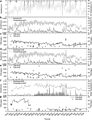
Table 2. Antecedent rainfall (mm), rainfall and runoff duration (h), total rainfall (mm) and runoff (mm), runoff ratios and wetland residence time (h) for 21 rainfall events. Runoff was determined using a straight-line hydrograph separation method to remove baseflow.
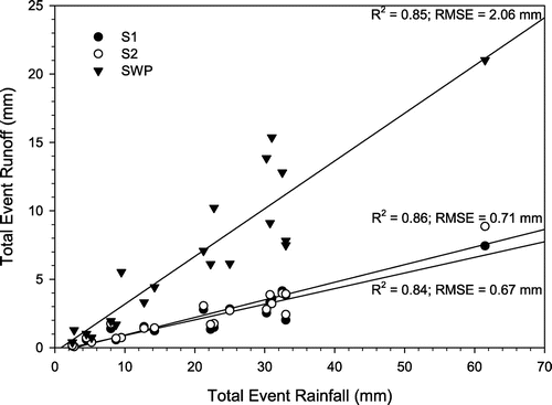
Regression analysis between the total rainfall and total runoff for each event indicates that the study catchment efficiently manages runoff for a variety of rainfall event magnitudes and durations (Figure ). Runoff correlates with rainfall for each event (S1, R2 = 0.84, Root Mean Square Error (RMSE) = 0.67 mm; S2, R2 = 0.86, RMSE = 0.71 mm; SWP, R2 = 0.85, RMSE = 2.06 mm). Regression analysis produced comparable correlations between all monitoring locations with different total catchment areas. The linear trends suggest that antecedent rainfall has a minimal impact on runoff, typical of impervious surfaces in urban catchments. Antecedent rainfall can have an effect on the linear regression, as the runoff response would be different in more natural catchments where soil moisture conditions and heavy vegetation influence runoff. Throughout most rainfall events, the average residence time of the PW was 2.2 ± 1.0 h (Table ).
Figure 4. The relationship between the total runoff and the total rainfall at S1, S2 and stormwater pond outlet (SWP) monitoring locations for each event between 25 April and 30 October 2014.
Water quality during and between runoff events
There was little difference (less than 1°C) between water temperatures at the S1 and S2 monitoring locations during the season. During rainfall events, there was a measured decrease in water temperature through the event, and in general, there was a strong diurnal temperature fluctuation on all days (Figure ). Average water temperatures at SWP were 16.6 ± 3.1°C, while the instream water temperatures were 16.0 ± 5.0°C and 14.6 ± 4.6°C, at S1 and S2, respectively. Water temperature lagged (~4–5 h) the diurnal atmospheric temperature, peaking between 16:00 and 17:00. There was no measurable difference in water temperature between S1 and S2 beyond the sensor resolution (Tables and ).
Table 3. Average event and baseflow water temperature, Total Dissolved Solids (TDS), and Total Suspended Solids (TSS), before and after the removal of the orifice plate at the Stormwater Pond (SWP). TSS values are from discrete samples, excluding the pump-sampling events. Effluent flow parameters are the difference obtained in subtracting S1 values from S2. Negative values suggest a decrease or dilution in the parameter.
Table 4. S1 and S2 difference of means (t-distribution) for Total Dissolved Solids (TDS), temperature, temperature (4:00–4:30) and Total Suspended Solids (TSS) with (25 April–25 June 2014) and without (8 September–30 October 2014) the Stormwater Pond (SWP) orifice plate.
TDS decreased as rainfall runoff response increased at the three monitoring locations (Figure ). A difference-of-means t-test (α = 0.05) shows a statistically significant difference in TDS between S1 and S2 before 27 June and no difference after 8 September (Table ). TDS concentrations were larger while the orifice plate was in place (Table ). Average effluent TDS was 32 ± 26 mg/L and 27 ± 30 mg/L for baseflow and event flow, respectively, before 27 June. It was much less for both baseflow and event flow conditions after 8 September (−5 ± 60 mg/L and 0.3 ± 7 mg/L, respectively; these values are the difference between S1 and S2). Effluent TDS during baseflow conditions had a large standard deviation, suggesting surface water would dilute the system but also release large TDS concentrations.
TSS was greater below the PW, as shown by the average TSS before and after the outlet orifice plate removal during baseflow and event flow conditions (Table ). There was no trend observed in the TSS data beyond the changes during events. Pump-sampler concentrations during the two measured events indicate that TSS was greater at S2 during events (Figure ). The 17 June maximum TSS was low, despite the large runoff response for this event (Table ; Figure ). The 14 October maximum TSS was much greater than that of the June event although total runoff was less than that of the 17 June event (Figure ). During the 14 October event rainfall intensity was low, with 4.5 mm in ~3 h and 0 mm in the previous 5 days (Table ). A t-test shows that there was a statistically significant difference in TSS between S1 and S2 for the 17 June event but not the 14 October event (Table ).
Figure 5. Total suspended solids (TSS) during rainfall events in June (a) and October (b). (a) 17 June rainfall event (mm), total runoff (mm) and TSS (mg/L). Low TSS was recorded for an intense rainfall event. (b) 14 October rainfall event (mm), total runoff (mm) and TSS (mg/L). Although the rainfall intensity was low, with 4.5 mm in 2.8 h, antecedent conditions were dry as 0 mm of rain fell in the previous 5 days.
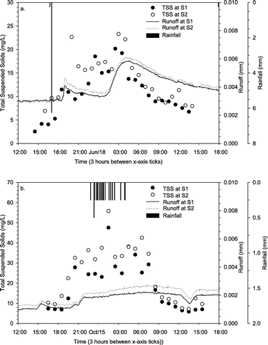
Table 5. S1 and S2 difference of means test (t-distribution) of the pump-sampler Total suspended solids (TSS) from the 17 June and 14 September 2014 rainfall events.
Discussion
Pocket wetland flow attenuation
The PW is the final stage in the stormwater treatment train and attenuates SWP outflow into the adjacent stream (Table ). Through monitoring S1, S2 and SWP it was determined whether the PW effectively managed runoff, temperature, TDS and TSS. If minimal changes occurred in the water quantity and quality between the S1 and S2 monitoring locations (Figure ), it would be reasonable to infer that the stormwater pond outflow (SWP) was not impacting the stream, and likely because the PW served to delay flow into the stream.
There was little change in runoff between the monitoring stations S1 and S2 but the flow into the PW from SWP was roughly 4 times the runoff within the stream (Table ). It is clear the PW attenuated the runoff from the SWP as influent water to the PW had limited measurable impact on runoff measured at the S2. Runoff ratios also support this conclusion as the stream experienced small ratios (0.11 ± 0.06) while the runoff ratios entering the wetland were larger (0.31 ± 0.11) (Table ). Urban runoff coefficients are expected to range from 0.40 to 0.95 for urban areas due to an increase in impermeable surface areas (Arnold Jr. and Gibbons Citation1996; Eimers and McDonald Citation2014). As ratios within the channel were low and more comparable to natural land-use runoff coefficients (0.05 – 0.40), this indicated an increase in detention provided by the SWM. Dietz and Clausen (Citation2008) compared traditional development techniques to LID techniques and found traditional techniques resulted in a 49,000% increase of annual runoff compared to a 0% increase under LID and SWM practices, as annual runoff went from 0.1 cm to roughly 50 cm, from a 31% increase in imperviousness. Results suggest that the PW will attenuate an average 0.17 ± 0.36 mm of the influent 6.80 ± 5.61 mm runoff from SWP, by providing active pool storage and pore space of the media below the wetland (Table ).
While few studies quantitatively measure the PW performance, Malaviya and Singh (Citation2012) advocate the use of PWs to further attenuate peak flows and improve the retention of stormwater runoff to enhance protection of stream systems in developed watersheds. Loperfido et al. (Citation2014) compared the runoff from four similar-sized catchments in a temperate environment with different land use and stormwater management practices. They found ~30% increase in runoff due to a 20% increase in impermeable surface area over catchments ranging from 1.11 to 7.02 km2 (Loperfido et al. Citation2014). The Churchville PW and other stormwater management practices reduced mean runoff ratios from 0.31 at SWP to 0.11 for the entire upstream catchment (Table ).
The minor increase in runoff at S2 suggests that only a small volume of water entered the stream during rainfall events (Table ). It is suggested that the ideal PW should detain water for 10–15 h for a 30-min rainfall event (Shutes et al. Citation1999). The average event residence time for the Churchville PW was 2.2 ± 1.0 h, while baseflow residence time, as it is reported in the literature, would be much longer (Wadzuk et al. Citation2010). The PW residence time has great potential to provide additional water quality improvements. The longer the residence time within the PW the greater the hydraulic efficiency (Persson et al. Citation1999). These systems must detain the water as close to the nominal residence time as possible to achieve the greatest water quality performance (Wong et al. Citation2006). During times of frequent rainfall events, mean residence time may decrease, as the volume of water within the PW has not had time to drain. This occurred on 11 June and 5 September, which had residence times roughly half that of the preceding rainfall event (Table ).
Thermal remediation of stormwater pond flow
Atmospheric temperatures are most influential to thermal regimes within a stream (Caissie Citation2006). Although atmospheric temperatures peaked around 30°C, water temperatures rarely exceeded 25°C (27 June–2 July). This is important to fish species as 25°C is the upper limit of the ideal range for the endangered redside dace (Novinger and Coon Citation2000). The Ontario Stream Assessment Protocol (Stanfield Citation2013) states water temperature must be assessed between 16:00 and 16:30, during which current study results detected no significant change (t-test, α = 0.05) in mean water temperature from S1 to S2 (Table ). Time series observations suggested that effluent PW runoff increased S2 water temperatures between 0.0 and 0.5 °C while a cooling effect ranging between 0.0 and 0.75 °C occurred more frequently during baseflow conditions, but neither trend was statistically significant. Mitsch et al. (Citation2005) attributed the warm water temperatures in PWs to a lack of established vegetation cover, which led to surface water warming by solar radiation. PWs need to provide dense vegetation to shade pooled water, thus dampening the warming effect. The Churchville PW is a newly constructed feature and it will take time for wetland vegetation to fully establish. Subsurface flow from the PW into the stream generated a cooling effect after effluent surface flows returned to average conditions, as seen by others (e.g. Poole and Berman Citation2001). The overall temperature gradient within the stream was minor, suggesting the PW design has no negative impacts with respect to thermal properties.
TDS remediation within the PW
TDS responded inversely to runoff, as it was relatively high during baseflow conditions, and decreased as runoff diluted the system at all three monitoring locations. A dilution in the system resulted in a lower TDS concentration throughout the field season. These findings are similar to those presented in a study by Wadzuk et al. (Citation2010) where TDS during baseflows were greater than those during rainfall events. S1, S2 and SWP had higher average TDS concentrations before 27 June (orifice plate in place) than after 8 September (orifice plate removed). Elevated TDS at SWP before 27 June is likely due to ponding water behind the orifice plate in the conduit. The stagnant water is subject to evaporation, which led to higher inferred TDS concentrations (Maurya et al. Citation2011). The results from the Churchville site suggest that the ‘first flush’ was more prevalent when the orifice plate was in place, and that the source of the ‘first flush’ was from the conduit itself (Figure ; Table ). Effluent PW runoff displayed little change to TDS within the stream after 8 September (Table ).
The PW was designed to act as a sink for particles and dissolved solids, providing an environment for sedimentation and sorption to occur. As long as sorption equilibrium has not been reached within the PW, an adequate residence time should allow bioremediation, and the physical or chemical adhesion to soil particles of dissolved nutrients in an aqueous phase, to occur (Malaviya and Singh Citation2012). Wadzuk et al. (Citation2010) found no change in TDS as water flowed through a 4000-m2 treatment wetland, with a rainfall event residence of just a few hours. There was no change in effluent conductivity during a 3-year study by Mitsch et al. (Citation2005) in which they artificially flooded a 11,600 m2 wetland. There were small improvements in effluent TDS of 78 mg/L during normal flow conditions (Mitsch et al. Citation2005). Both the Wadzuk et al. (Citation2010) and Mitsch et al. (Citation2005) studies have similar results to the present study and illustrate the relationship between residence time within treatment wetlands and runoff water quality.
Mobilizing suspended solids
TSS at SWP varied by 6 mg/L throughout the field season with four cases where it increased to 10–30 mg/L (Figure ). Three of these cases occurred before 27 June (orifice plate in place), during runoffs greater than 0.0076 mm. Results suggest that at times when there was a noticeable increase in velocity at SWP, sediment that settled behind the orifice plate in the conduit from stormwater pond mobilized. This sediment was not from the stormwater pond as it drains from the bottom of the settling water column. Although TSS was high at these times, there were minimal changes in the TSS within Churchville Creek. The difference-of-means t-test suggests there was no major difference between the S1 and S2 monitoring points, but this test was statistically insignificant due to the small sample size (Table ). Van de Moortel et al. (Citation2009) found the removal of TSS was most efficient as water moved through sub-surface pathways. They noticed sedimentation would also take place given sufficient retention time. Although there was no significant change in retention time at the Churchville PW, effluent TSS showed a significant decrease from influent TSS (Table ).
Discrete sampling during rainfall events following 8 September showed larger effluent TSS at the Churchville PW (Table ). Discrete samples showed an increase in TSS during rainfall events (influent, 3.28 ± 1.59 mg/ L; effluent, 4.26 ± 15.67 mg/ L). Other studies reported improvements of TSS through PW for base and event flows (Carleton et al. Citation2001; Wadzuk et al. Citation2010). Mitsch et al. (Citation2005) reported an increase of soil development within the wetland over a 10-year period, but found this led to an increase in the export of TSS. They suggest that during rainfall events, anaerobic soil water along the edge of the PW is mixed into moving surface water, flushing the system (Mitsch et al. Citation2005). The average rainfall at the Churchville subwatershed was much larger after 8 September (~17.40 mm), which would regularly flush the system, releasing higher TSS. Effluent TSS during baseflow had a low average but high standard deviation (1.95 ± 6.92 mg/L and −0.45 ± 15.39 mg/L, before and after the orifice plate removal, respectively). Due to the small-incised channel, a small flux of sediment entered the stream as the surface water drained from the PW. When considering Mitsch et al. (Citation2005) suggestions about still water, as surface water drains from different areas of the PW the flux of TSS within these locations would explain the high standard deviation.
The pump-sampler TSS responded similarly to TDS during the rainfall events (Figure ). The greatest difference from S1 to S2 occurred roughly 2 h after it began to rain, represented as the ‘first flush’ of mobilized sediments from the storm. After the initial pulse of water, there was no clear trend with a change in TSS at S2 even though there was a peak change in runoff of 9.7 × 10⁻⁴ mm and 5.8 × 10⁻⁴ mm during the 17 June and 14 October events, respectively. Other than the ‘first flush’ from the initial rainfall, the differences in S1 and S2 TSS were within the range of the TSS differences recorded from discrete sampling. This contradictsthe findings of Wadzuk et al. (Citation2010) that indicated an average increase in TSS of ~20 kg for all rainfall events compared to baseflow conditions. Furthermore, the comparison between the S1 and S2 monitoring points within the stream suggests that the PW is not acting as a major source for TSS during high-flow events.
Conclusion
PWs are an effective addition to the stormwater treatment train as demonstrated by the assessment at Churchville Creek in Brampton, Ontario. The PW attenuated flow from the stormwater pond with an average residence time of ~2 h. Antecedence was the only factor that changed residence time, as the PW had a limited storage capacity for stormwater runoff. The downstream water quality represented no significant change due to effluent PW runoff. The PW resulted in no measurable change in stream water temperature from upstream to downstream of the urban catchment inputs. The PW effectively remediated TDS concentrations, while close analysis suggested surface water drainage during baseflow resulted in a small flux in TDS. Most importantly, the TDS concentrations never exceeded published water quality standards. Rainfall events later in the season resulted in larger releases of TSS but this was due to larger rainfall events and dryer antecedent conditions.
A longer residence time would further improve flow attenuation and water quality, but a longer residence time would only happen with a larger PW. In a general, the small PW between the SWP outlet and the adjacent stream is effective. Furthermore, it is not a hindrance, as it does not appear to be a major source of TDS or TSS. The incised channel from the PW continuously drained into Churchville Creek and reduced residency within the wetland; again, this did not impact the stream and potentially ensured that the PW would perform adequately during runoff events. PWs are an important and valuable addition to the stormwater treatment train approach and should be included in future planning.
Funding
Field equipment and analyses were supported by infrastructure grants to JC from the Canadian Foundation for Innovation and the Ontario Research Fund, as well as equipment from GEO Morphix Ltd. The Department of Geography supported field and sample analysis, especially Mario Finoro, Sandy McLaren and Marie Puddister.
Acknowledgements
We are grateful to Dr. Andrea Bradford for providing comments on an earlier draft, and for the thorough reviews provided by two anonymous reviewers. Dorian Pomezanski, Samantha Feist and Jesse Van Patter provided able and enthusiastic assistance in the field and laboratory.
References
- Arnold Jr, C., and C. Gibbons. 1996. Impervious surface coverage: The emergence of a key environmental indicator. Journal of the American Planning Association 62: 243–258.10.1080/01944369608975688
- Atekwana, E. A., E. A. Atekwana, R. S. Rowe, D. D. Werkema, and F. D. Legall. 2004. The relationship of total dissolved solids measurements to bulk electrical conductivity in an aquifer contaminated with hydrocarbon. Journal of Applied Geophysics 56: 281–294.10.1016/S0926-9851(04)00057-6
- Booth, D.B., and B.P. Bledsoe. 2009. Streams and urbanization. In The Water Environment of Cities. ed. L.A. Baker, 93–123. Boston, MA: Springer US.10.1007/978-0-387-84891-4
- Brabec, E. A. 2009. Imperviousness and land-use policy: Toward an effective approach to watershed planning. Journal of Hydrologic Engineering 14: 425–433.10.1061/(ASCE)1084-0699(2009)14:4(425)
- Bradford, A., and B. Gharabaghi. 2004. Evolution of Ontario’s stormwater management planning and design guidance. Water Quality Research Journal of Canada 39: 343–355.
- Brown, R. R., N. Keath, and T. H. F. Wong. 2009. Urban water management in cities: Historical, current and future regimes. Water Science & Technology : A Journal of the International Association on Water Pollution Research 59: 847–855.10.2166/wst.2009.029
- Burns, M. J., T. D. Fletcher, C. J. Walsh, A. R. Ladson, and B. E. Hatt. 2012. Hydrologic shortcomings of conventional urban stormwater management and opportunities for reform. Landscape and Urban Planning 105: 230–240.10.1016/j.landurbplan.2011.12.012
- Caissie, D. 2006. The thermal regime of rivers: a review. Freshwater Biology 51: 1389–1406.10.1111/fwb.2006.51.issue-8
- Carleton, J., T. Grizzard, A. Godrej, and H. Post. 2001. Factors affecting the performance of stormwater treatment wetlands. Water Research 35: 1552–1562.10.1016/S0043-1354(00)00416-4
- Credit Valley Conservation Authority. 2004. Credit Valley Subwatershed Study: Huttonville Creek (7), Springbrook Creek (8a), Churchville Tributary (8b). http://www.creditvalleyca.ca/watershed-science/our-watershed/subwatershed-studies/subwatershed-8a/.
- Davis, A. P., J. H. Stagge, E. Jamil, and H. Kim. 2012. Hydraulic performance of grass swales for managing highway runoff. Water Research 46: 6775–6786.10.1016/j.watres.2011.10.017
- Dietz, M. E., and J. C. Clausen. 2008. Stormwater runoff and export changes with development in a traditional and low impact subdivision. Journal of Environmental Management 87: 560–566.10.1016/j.jenvman.2007.03.026
- Eimers, M. C., and E. C. McDonald. 2014. Hydrologic changes resulting from urban cover in seasonally snow-covered catchments. Hydrological Processes 29: 1280–1288.
- Endangered Species Act, SO 2007, c 6, s 7.
- Endreny, T., and V. Collins. 2009. Implications of bioretention basin spatial arrangements on stormwater recharge and groundwater mounding. Ecological Engineering 35: 670–677.
- Hunt, W. F., A. P. Davis, and R. G. Traver. 2012. Meeting hydrologic and water quality goals through targeted bioretention design. Journal of Environmental Engineering 138: 698–707.10.1061/(ASCE)EE.1943-7870.0000504
- Konrad, C., and D. Booth. 2005. Hydrologic changes in urban streams and their ecological significance. American Fisheries Society Symposium 47: 157–177.
- Lawler, D. M., G. E. Petts, I. D. L. Foster, and S. Harper. 2006. Turbidity dynamics during spring storm events in an urban headwater river system: The Upper Tame, West Midlands, UK. Science of the Total Environment 360: 109–126.10.1016/j.scitotenv.2005.08.032
- Li, H., and A. P. Davis. 2009. Water quality improvement through reductions of pollutant loads using bioretention. Journal of Environmental Engineering 135: 567–576.10.1061/(ASCE)EE.1943-7870.0000026
- Loperfido, J. V., G. B. Noe, S. T. Jarnagin, and D. M. Hogan. 2014. Effects of distributed and centralized stormwater best management practices and land cover on urban stream hydrology at the catchment scale. Journal of Hydrology 519: 2584–2595.10.1016/j.jhydrol.2014.07.007
- Malaviya, P., and A. Singh. 2012. Constructed wetlands for management of urban stormwater runoff. Critical Reviews in Environmental Science and Technology 42: 2153–2214.10.1080/10643389.2011.574107
- Marandi, A., M. Polikarpus, and A. Jõeleht. 2013. A new approach for describing the relationship between wlectrical conductivity and major anion concentration in natural waters. Applied Geochemistry 38: 103–109.10.1016/j.apgeochem.2013.09.003
- Maurya, A. S., M. Shah, R. D. Deshpande, R. M. Bhardwaj, A. Prasad, and S. K. Gupta. 2011. Hydrograph separation and precipitation source identification using stable water isotopes and conductivity: River Ganga at Himalayan foothills. Hydrological Processes 25: 1521–1530.10.1002/hyp.v25.10
- Mitsch, W. J., L. Zhang, C. J. Anderson, A. E. Altor, and M. E. Hernández. 2005. Creating riverine wetlands: Ecological succession, nutrient retention, and pulsing effects. Ecological Engineering 25: 510–527.10.1016/j.ecoleng.2005.04.014
- Novinger, D., and T. Coon. 2000. Behavior and physiology of the redside dace, Clinostomus elongatus, a threatened species in Michigan. Environmental Biology of Fishes 57: 315–326.10.1023/A:1007526414384
- Paul, M., and J. Meyer. 2001. Streams in the urban landscape. Annual Review of Ecology and Systematics 32: 333–365.10.1146/annurev.ecolsys.32.081501.114040
- Pellerin, B., and W. Wollheim. 2008. The application of electrical conductivity as a tracer for hydrograph separation in urban catchments. Hydrological Processes 22: 1810–1818.10.1002/(ISSN)1099-1085
- Persson, J., N. Somes, and T. Wong. 1999. Hydraulics efficiency of constructed wetlands and ponds. Water Science and Technology 40: 291–300.
- Pitt, R. 1999. Small storm hydrology and why it is important for the design of stormwater control practices. Advances in Modeling the Management of Stormwater Impacts 7: 1–31.
- Poole, G. C., and C. H. Berman. 2001. An ecological perspective on in-stream temperature: natural heat dynamics and mechanisms of human-caused thermal degradation. Environmental Management 27: 787–802.10.1007/s002670010188
- Pyke, C., M. P. Warren, T. Johnson, J. LaGro, J. Scharfenberg, P. Groth, R. Freed, W. Schroeer, and E. Main. 2011. Assessment of low impact development for managing stormwater with changing precipitation due to climate change. Landscape and Urban Planning 103: 166–173.10.1016/j.landurbplan.2011.07.006
- Roy-Poirier, A., P. Champagne, and Y. Filion. 2010. Review of bioretention system research and design: Past, present, and future. Journal of Environmental Engineering 136: 878–889.10.1061/(ASCE)EE.1943-7870.0000227
- Sansalone, J. J., and C. M. Cristina. 2004. First flush concepts for suspended and dissolved solids in small impervious watersheds. Journal of Environmental Engineering 130: 1301–1314.
- Scholes, L., D. M. Revitt, and J. B. Ellis. 2008. A systematic approach for the comparative assessment of stormwater pollutant removal potentials. Journal of Environmental Management 88: 467–478.10.1016/j.jenvman.2007.03.003
- Shutes, R. B., D. M. Revitt, I. M. Lagerberg, and V. C. Barraud. 1999. The design of vegetative constructed wetlands for the treatment of highway runoff. The Science of the Total Environment 235: 189–197.10.1016/S0048-9697(99)00212-0
- Shutes, R. B., J. B. Ellis, D. M. Revitt, and L. N. L. Scholes. 2005. Constructed wetlands in UK urban surface drainage systems. Water Science and Technology: A Journal of the International Association on Water Pollution Research 51: 31–37.
- Stanfield, L.W. (editor). 2013. Ontario Stream Assessment Protocol. Version 9.0 Fisheries Policy Section. Ontario Ministry of Natural Resources. Peterborough, Ontario. http://www.trca.on.ca/the-living-city/monitoring/ontario-stream-assessment-protocol.dot
- Stanfield, L. W., and D. A. Jackson. 2011. Understanding the factors that influence headwater stream flows in response to storm events. Journal of American Water Resources Association 47: 315–336.10.1111/jawr.2011.47.issue-2
- Stanfield, L. W., and B. W. Kilgour. 2006. Effects of percent impervious cover on fish and benthos assemblages and instream habitats in Lake Ontario tributaries. American Fisheries Society Symposium 48 : 577–599.
- Van de Moortel, A. M. K., D. P. L. Rousseau, F. M. G. Tack, and N. De Pauw. 2009. A comparative study of surface and subsurface flow constructed wetlands for treatment of combined sewer overflows: A greenhouse experiment. Ecological Engineering 35: 175–183.10.1016/j.ecoleng.2008.08.015
- Wadzuk, B. M., M. Rea, G. Woodruff, K. Flynn, and R. G. Traver. 2010. Water quality performance of a constructed stormwater wetland for all flow conditions. Journal of the American Water Resources Association 46: 385–394.10.1111/j.1752-1688.2009.00408.x
- Walton, N. R. G. 1989. Electrical conductivity and total dissolved solids – What is their precise relationship? Desalination 72: 275–292.10.1016/0011-9164(89)80012-8
- Wong, T. H. F., T. D. Fletcher, H. P. Duncan, and G. A. Jenkins. 2006. Modelling urban stormwater treatment – A unified approach. Ecological Engineering 27: 58–70.10.1016/j.ecoleng.2005.10.014