
Abstract
Water well drilling records combined with geologic observation around Sylvan Lake suggest a permeable, fractured groundwater-bearing channel sandstone extends along the northeast margin of the lake, and is surrounded by a matrix of shale with small sandy interbeds. Chloride and water isotope mass-balance approaches found groundwater fluxes were 37 to 43% of total annual lake water inputs, and were consistent with Darcy flux estimates for the channel sandstone. The groundwater contribution to the lake water budget contributes to an estimated lake-water residence time ranging from 22 to 30 years, which is much lower than other lakes in the region and lakes of similar size. Groundwater through-flow in the hydraulically connected channel sandstone unit of the Paskapoo Formation appears to play a critical role in maintaining the relatively low total dissolved solids (and trophic status) of Sylvan Lake, as compared to other lakes in south-central Alberta. Due to the hydraulic connection of the sandstone channel with Sylvan Lake, land use along the north side of the lake (above the sandstone channel unit) should be carefully considered to mitigate groundwater (and consequently lake water) quality impacts.
La considération en parallèle les données de forages pour l’eau et les observations géologiques aux alentours du lac Sylvain suggèrent l’existence d’une veine de grès perméable et fracturée, s’allongeant le long de la marge nord-est du lac et entourée d’une matrice de schiste contenant de petits interlits sableux. Le bilan massique des isotopes de chlore et de l’eau indique que les apports d’eau souterraine contribuent de 37 % à 43 % de l’apport hydrique annuel total du lac, ce qui est en accord avec l’estimation des flux de Darcy pour la veine de grès. Cet apport d’eau souterraine au lac contribue à un temps de séjour entre 22 et 30 ans, un temps de séjour très court par rapport à celui des lacs dans la région et des lacs de dimensions similaires. L’écoulement souterrain dans le grès de la Formation de Paskapoo semble jouer un rôle crucial pour le maintien de la concentration relativement basse de solides totaux dissous (et l’état trophique) du lac Sylvan par rapport à d’autres lacs du Centre-Sud de l’Alberta. Étant donné le lien hydraulique entre le grès et le lac Sylvan, l’utilisation des terres longeant la côte nord du lac (au-dessus du grès) devrait être soigneusement étudiée pour d’éviter une contamination de l’eau souterraine, et conséquemment du lac.
Introduction
Groundwater and surface water are increasingly viewed as a single, complex and interconnected system (Grasby et al. Citation1999; Winter Citation1999; Rosenberry et al. Citation2015). As the demand for water increases, improved understanding of the influence that groundwater has on the occurrence, quantity and quality of surface water is critical. Sustainable development and responsible management of lakes require a detailed knowledge of water fluxes through a lake (Hood et al. Citation2006; Rosenberry et al. Citation2015). Groundwater fluxes are a particularly challenging component of a lake water budget to quantify because they are difficult to measure and often spatially variable (Hagerthey and Kerfoot Citation2005; Kluge et al. Citation2012; Shaw et al. Citation2013).
Sylvan Lake is a preferred recreational destination in south-central Alberta, Canada (hosting more than one million tourist visits per year) in a small watershed that is already relatively developed (with four villages, one town [population 13,000], and two provincial parks), and is under increasing development pressure (Figure ; Crosby Citation1990; ALMS Citation2010). Part of the tourism popularity of this lake is derived from its unusually low trophic status for the region. Sylvan Lake has the lowest trophic status not only of 10 natural lakes with long-term water quality monitoring data in the dry mixwood natural subregion of Alberta, but also of 28 natural lakes in the Alberta prairie subregion (Figure ; Casey Citation2011; Gibson et al. Citation2016). Sylvan Lake also has a relatively low total dissolved solids (TDS) concentration (300 to 350 mg/L) relative to other lakes in the region (Baker Citation2009).
Figure 1. Location of Sylvan Lake Watershed showing the Town of Sylvan Lake, main highways, Alberta Environment and Parks (AEP) nested well locations, approximate location of the sandstone channel, the location of Sunbreaker Cove and Jarvis Bay Research Wells, and the groundwater and lake water sample locations. Bedrock geology in the region is not marked since the entire area is underlain by the Paskapoo Formation (Grasby et al. Citation2008).
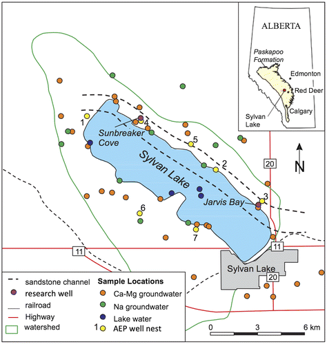
Figure 2. Trophic statuses of natural (i.e. non-reservoir) Alberta lakes in Alberta prairies (excluding Foothill and Rocky Mountain regions) with long-term datasets available (≥ 10 years of open-water composite samples in provincial monitoring programmes; Casey Citation2011). Trophic statuses are represented by mean concentrations of chlorophyll-a and total phosphorus from the long-term data sets (Casey Citation2011).

The unusually low TDS and trophic status is unexpected given Sylvan Lake’s (1) small watershed area (167 km2, including the lake) relative to the lake area (42.8 km2); (2) only intermittently significant surface water inflow or outflow, which typically occurs during only one or two seasons per decade (Figliuzzi Citation1976; Crosby Citation1990); (3) high estimated average lake-water residence time of >100 yrs (Crosby Citation1990; Casey Citation2011); and (4) nutrient loading related to development. In addition to its low trophic status, phosphorus concentrations have not increased significantly in Sylvan Lake, in contrast to significant increases in about 25% of Alberta lakes with long-term records (Casey Citation2011).
Since the lack of surface outflow implies Sylvan Lake is effectively a closed-basin lake, we examined the potential that groundwater flux into and out of Sylvan Lake contributes to its low trophic status. Drilling and pump testing of two research wells were combined with water well records and geological observations to characterise a sandstone channel extending along the northeast margin of the lake. Two mass balance approaches (including chloride and water isotopes) were supported by Darcy flux calculations for the channel sandstone to provide a robust estimate of the rate of groundwater flux through Sylvan Lake.
Study area
Sylvan Lake is located 19 km northwest of Red Deer, Alberta (Figure ). The area has a boreal climate, which consists of low mean annual temperatures, short cool summers and long cold winters (Moran and Morgan Citation1991). The highest mean monthly precipitation occurs in July (102.7 mm), with a mean annual precipitation of 550.4 mm/yr (calculated for 1961 to 1990; Environment Canada Citation2007) and an estimated mean annual lake evaporation of 640 mm/yr (Government of Canada, Citation2017).
Geology
Surficial sediments in the watershed consist of clay and till to sandy clay and sandy till, and range in thickness from less than 1 m to over 15 m (Crosby Citation1990). There is moderately to strongly developed hummocky terrain to the northwest of Sylvan Lake in the Medicine Lodge Hills (Shetson Citation1990). These surficial sediments are underlain by the Paleocene Paskapoo Formation, which consists of interbedded shales and sandstones (Grasby et al. Citation2008). The depositional environment of the Paskapoo grades from braided to meandering to anastomosing stream environments. The sandstones tend to be isolated, channel shaped and of limited areal extent, and tend to occur in stacked fining-upwards sequences (Grasby et al. Citation2008; Burns et al. Citation2010). Groundwater flow predominates in the permeable sandstone channels, causing significant anisotropy in the Paskapoo Formation regionally (Burns et al. Citation2010). Sandstone cliffs on the northeast margin of Sylvan Lake indicate the presence of a sandstone channel directly connected to the lake. The lateral extent of this channel feature is defined further in the Geology section below.
Hydrology and hydrogeology
Sylvan Lake is fed by several short (less than 7 km), small-discharge (<0.001 m3/s), perennial streams that are sourced from groundwater springs and augmented by snowmelt water and surface water runoff that form the principal surface water inputs into the lake. There are no significant anthropogenic withdrawals or inputs that affect the lake water balance. The single surface water outlet, located at the southeast end of the lake, flows only intermittently (e.g. three seasons between 1955 and 1976; Crosby Citation1990) when the lake reaches a threshold water level of approximately 936.73 metres above sea level (masl; Figliuzzi Citation1976). The last period of significant surface water outflow from Sylvan Lake occurred during the open water seasons between 1992 and 1995, with flow rates in the range of 0.001 to 0.626 m3/s. Long-term estimated total annual outflows during this time are about 1.6% of the lake volume, with an estimated average lake water residence time of >100 years (Casey Citation2011). Since 1995, low-discharge flow from Sylvan Lake was only recorded in August 2007 (0.027 m3/s; Alberta Environment and Parks [AEP], unpublished data), making Sylvan Lake effectively a closed-basin lake. Closed-basin lakes typically occur in climates where evaporation is greater than precipitation, and are connected with a regional interfluvial water table (or, in other words, where there may be an exchange of groundwater from outside of the topographic watershed; Almendinger Citation1990).
Groundwater wells for domestic and municipal use in the Sylvan Lake watershed are mainly completed in the Paskapoo Formation. This formation extends over a large part of southern and central Alberta and is the most significant groundwater source in the Canadian Prairies (Grasby et al. Citation2008). The Paskapoo Formation consists of a system of higher permeability paleochannels that are surrounded by a matrix of low-permeability shaley overbank deposits (Grasby et al. Citation2008; Burns et al. Citation2010). The high permeability sand channels form only a minor volumetric component of the Paskapoo Formation (~23%; Grasby et al. Citation2008). Sand channel orientation along with fracture systems formed in response to the regional stress field (Bell and Grasby Citation2011) impart an overall NE–SW preferential transmissivity field to the aquifer (Grasby et al. Citation2008; Chen et al. Citation2011). However, on a local scale, hydraulic heads in water wells show the highest horizontal gradients towards Sylvan Lake are mainly from the west and north (Figure ). Since relatively high hydraulic gradients tend to occur in formations with relatively low hydraulic conductivity values, they are not necessarily associated with significant groundwater flow rates.
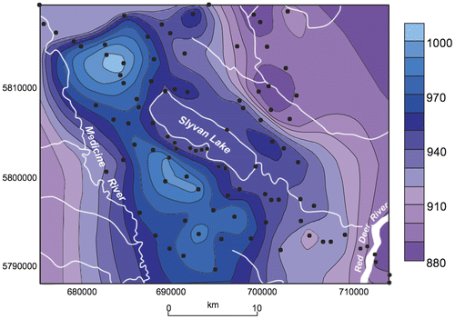
Figure 3. Potentiometric surface map (in metres above sea level) in the region as interpolated from original non-pumping water levels from Alberta water well drilling records. Black dots represent data control points.
Methods
Drilling and coring
Water well records were augmented with drilling and coring of two research wells to understand the extent, lithology and hydrogeologic characteristics of the channel sandstone along the north side of Sylvan Lake. The research wells were each installed close to a set of existing AEP nested monitoring wells, one at Sunbreaker Cove (Sunbreaker Cove Research Well) and the other at Jarvis Bay (Jarvis Bay Research Well) (Figure ). At each location, core was recovered starting from the top of the weathered bedrock to the shale below the bottom of the sandstone aquifer (~61 m at Jarvis Bay, ~46 m at Sunbreaker Cove). The wells were completed with a 25.4-cm diameter steel casing and 15.24-cm diameter polyvinyl chloride (PVC) liner. The liner was screened for 6.1 m in the middle of the sandstone aquifer.
Pumping test
Estimates of the hydraulic properties of the sandstone channel aquifer within the Paskapoo Formation were based on a 3-day pumping test at Sunbreaker Cove. The Sunbreaker Cove Research Well was pumped at a rate of 1 m3/min for 3 full days, followed by 3 days of monitored recovery. The three nested wells at Well Nest 4 were used as observation wells, in addition to two nearby private water wells. Pumping discharge water was monitored for pH, temperature (T), dissolved oxygen (DO), oxygen-reduction potential (ORP) and electrical conductivity (EC), and samples were collected for geochemical analyses and hydrogen and oxygen isotopic composition (as described below). Details of the pumping tests are in Baker (Citation2009).
Hydraulic heads and gradients
Three AEP well nests were surveyed using the lake level as a datum, on 26 September 2006. Historical water levels were then compared to historical lake levels to estimate hydraulic gradients between the nested wells and the lake.
Geochemistry
The field sampling programme included 42 domestic water wells from sites surrounding the lake (Figure ; Table ), nine lake water samples and two nearby shallow groundwater springs. Water from domestic water wells was sampled via a flow-through cell connected to an outside tap of a home (not connected to a water softener unit). Sampling was initiated after T, pH, DO, EC and ORP probes displayed stable readings (typically after running the water for 5 to 15 min). The stable field parameters were recorded and water samples subsequently collected. Lake water samples were collected from depths ranging from the surface to a maximum of 17 m depth in October 2004 and October 2006 from a location near the deepest part of the lake using a VanDorn water sample collector.
Table 1. Stable water isotopes values, electrical conductivity (EC), geochemical analyses of Sylvan Lake water, groundwater from domestic wells, and groundwater from research wells. Values are in mg/L unless otherwise stated.
Alkalinity was determined using an Orion 960 Autotitrator by addition of H2SO4 and measured with a ROSS pH electrode. Anions and cations were analysed at the Geological Survey of Canada. Anions were determined using Dionex Ion Liquid Chromatography. Cations were determined using a Spectro Arcos high resolution Axial inductively coupled plasma atomic emission spectroscopy. Oxygen and hydrogen isotopes in water were analysed relative to Vienna Standard Mean Ocean Water (V-SMOW).
Groundwater flux quantification
Given inherent uncertainties in any single approach for estimating groundwater flux, two independent mass balances approaches (including chloride and water isotope mass balances) were conducted and compared to Darcy flux estimates of groundwater flow through the sandstone channel on the northeast margin of Sylvan Lake.
Darcy flux estimates
Darcy through-flow flux calculations for geologically well-defined aquifers are often used in groundwater–lake interaction studies (Shaw and Prepas Citation1990; Shaw et al. Citation2013; Rosenberry et al. Citation2015) since they provide a physically based estimate to which tracer and chemical estimates can be compared. Even though Darcy flux calculations are inherently difficult to constrain (in particular for hydraulic conductivity values), they increase the robustness of the overall approach, and provide a physically based check on the mass balances. This approach is based on estimating groundwater flow in an aquifer from direct physical properties such as the hydraulic conductivity and the hydraulic gradient using Darcy’s Law (Freeze and Cherry Citation1979):(1)
where Q is discharge, K is hydraulic conductivity for the sand channel, (dh/dl) is hydraulic gradient and A is the cross-sectional area of the channel. However, this provides only a rudimentary (in this case sub-aquifer) estimate.
Sources of error for this method include the hydraulic conductivity estimation (typically reliable to the order of magnitude only, although pumping tests with observation wells like the one conducted here are the most appropriate method of determining robust K values; Freeze and Cherry Citation1979), the cross-sectional area of the sandstone channel that is hydraulically connected to Sylvan Lake, and the hydraulic gradient. It is possible to estimate an upper limit of the cross-sectional area by assuming the entire saturated thickness of the channel (estimated from drill core and water levels) occurs along the entire northeast side of the lake (Figures and ), and is in hydraulic connection with the lake. Additional, but smaller, error introduced by the hydraulic gradient calculations stem from measurement error (typically within a few cm for elevation and/or hydraulic head values, and within a few m for distance estimations between the piezometer location and the lake shore) and the possibility of underestimation by measuring the hydraulic gradient along a horizontal path that is not aligned with that of the true gradient.
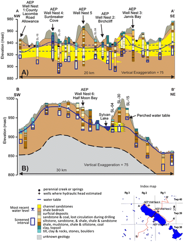
Figure 4. Hydrogeological cross-sections along (A) long axis of the Sylvan Lake watershed (northwest (NW) to southeast (SE)), and (B) short axis of the Sylvan Lake watershed (southwest (SW) to northeast (NE)). The section was constructed using water well drilling records from Alberta water well drilling records and well logs from Alberta Environment and Parks (AEP) groundwater monitoring well nests. Topography, bedrock surface, water table surface, and locations where hydraulic heads were measured for hydraulic gradient calculations are indicated.
Chloride mass balance
Chloride is a conservative solute in freshwater, gained and lost solely through mass transport from source waters entering the lake and water leaving the lake (Appelo and Postma Citation1996; Iwanyshyn et al. Citation2008). Baker (Citation2009) showed that there is no statistical change in chloride concentrations of Sylvan Lake over the last ~40 years of record (despite more than a 10-fold increase in population in the Sylvan Lake watershed). This indicates that potential anthropogenic sources of chloride (e.g. road salt and septic systems) are minor and can be excluded from this model. Excluding potential anthropogenic input also provides a more conservative estimate of groundwater discharge from the lake.
Two mass balance equations are combined here. The first represents the flux of water exchanged between the lake and the surrounding environment, and a second set of equations describes the mass chloride mass balance. Since lake water levels have varied by less than 1.5 m (with no systematic trend) over decadal time scales (ALMS Citation2010), and in the absence of a significant surface water outlet (see above), a water-balance equation can be written as follows:
(2)
where δS = mean annual change in storage in the lake (m3); P = mean annual precipitation on the lake (m3); R = mean annual runoff (m3); I = mean annual groundwater flux into the lake (m3); E = mean annual evaporation (m3); and O = mean annual groundwater flux out of the lake (m3).
Given that there has been no statistical change in chloride concentration in the lake over time, a chloride mass balance equation can be written where mass fluxes, as estimated by multiplying the concentration of chloride for a given water balance component by the annual volume of the given water balance component, are balanced:
(3)
where = annual change in mass of chloride in the lake;
= annual mass of chloride added to the lake from precipitation;
= annual mass of chloride added to the lake from the runoff;
= annual mass of chloride added to the lake from groundwater; and
= annual mass of chloride lost from the lake through groundwater outflow. The last term can be restated as
because the groundwater outflow from the lake would have the same chloride concentration as the lake. Evaporation is not considered since it is assumed to not affect the chloride mass in Sylvan Lake.
Since mass is the product of volume multiplied by concentration, Equation Equation(3)(3) can be rewritten as:
(4)
where Vx = annual volumetric flux (m3/yr) and [Cl]x = concentration of chloride of ‘x’; where ‘x’ denotes subscripts as follows: L = lake, P = precipitation, R = runoff, I = groundwater inflow and O = groundwater outflow. The unknown fluxes (VI and VO) are solved for by combining Equations (Equation2(2) ) and (Equation4
(4) ) (calculated results are given in the Results section below).
The precipitation amount used was the average value from the Sylvan Lake meteorological station over the period 1971 to 2000 (Environment Canada Citation2007), and precipitation chloride concentration was the average value for Red Deer estimated from Environment Canada’s Canadian National Atmospheric Database (Environment Canada Citation2005). The mean annual shallow lake evaporation, 640 mm, was estimated by the Morton method (Government of Canada Citation2017). The lake water chloride concentration used was the average of long-term lake quality monitoring from all Sylvan Lake sampling stations over the period 1974 to 2001 (collated in Baker Citation2009). Notably, no decadal-scale trends were reported for chloride or for other parameters observed over time between 1983 and 2008 (including total dissolved solids, total P, pH, ammonia, and nitrate; Casey Citation2011). The runoff quantity was interpolated from the map of surface water runoff (Alberta Environment Citation2005) where the contour interval was 10 mm, and Sylvan Lake fell within the contour interval representative of 40 to 50 mm of runoff. The maximum and minimum values in the watershed area, and a mid-range observed visually, were used in the lake balance calculations. The runoff water chloride concentration was obtained from the two samples collected from spring-derived streams in the watershed.
Oxygen and deuterium isotope mass balances
The amount of evaporative enrichment of water isotopes in lake water is predictable given certain temperature and humidity conditions (Craig and Gordon Citation1965). There are a number of assumptions inherent in this isotope mass balance method, including: (1) constant density of water, (2) a well-mixed lake, (3) non-seasonality (i.e. seasonal climatic changes are minimal), (4) similar climatic conditions over time (years), (5) initial isotopic composition of lake is equal to the input isotopic composition (i.e. when lake was initially formed), (6) average annual isotope values for both precipitation and groundwater are constant over time, and (7) steady state (i.e. hydrologic fluxes are constant over time, and changes in lake volume are minimal). These assumptions are valid for the purposes of this study given that: (1) Sylvan Lake watershed is a freshwater basin; (2) there is a high degree of mixing of Sylvan Lake, as demonstrated by T, DO and EC profiles of the lake which vary vertically by less than 10% (Baker Citation2009); (3) non-seasonality of evaporation was accounted for by using the 30-year normal for temperature and humidity from only the open water season (May through October when the lake is typically ice-free); (4) the climatic inputs to the mass balance are an integrated signal (30-year normals; Environment Canada Citation2007) and account for minor fluctuations in the climate over time; (5) the two main inputs of water to the lake are precipitation and groundwater, which have similar isotopic compositions (see below); and (6) the lake water level shows steady-state conditions.
An isotope mass balance method that considers the oxygen and deuterium signatures in water (Gibson et al. Citation2002) was used here. The inputs to the isotope mass balance method include the air temperature, the humidity and the input isotopic signature. The equilibrium fractionation factors, , for oxygen (δ18O) and deuterium (δ2H) are calculated based on the temperature (T) and humidity (h) (Majoube Citation1971).
(5)
(6)
These fractionation factors for 18O (α* = 1.01) and 2H (α* = 1.11) were used in Equation Equation(7)(7) to calculate the equilibrium separation factors,
:
(7)
The kinetic separation factor () is related to the humidity (h) by the following equation:
(8)
where the kinetic separation constant, Ck is equal to:(9)
where D is the molecular diffusion coefficient of the light isotope and Di is the molecular diffusion coefficient of the heavy isotope. A turbulence parameter, n, of 0.5 is suitable for natural evaporation from lakes (Gonfiantini Citation1986) and relates to kinetic separation constants of 14.3‰ for oxygen and 12.5‰ for hydrogen. The total separation factor is the sum of the kinetic and equilibrium separation factors.
Once the separation factors are calculated, they can be used to estimate the ambient atmospheric isotopic composition using Equation (10):(10)
where δp is the input isotopic composition of flux-weighted precipitation during the open-water season (May through October) from Peng et al. (Citation2004).
Results
Jarvis Bay core
The upper bedrock lithology consists of interbedded sandstones and shales to a depth of 17.8 m which are underlain by a thick coarse-grained sandstone package that has a fining upwards sequence and extends to a depth of 36.8 m. The water level was at 27 mbgs (metres below ground surface) and approximately 10 m below the top of the sandstone package. The sandstone package was underlain by interbedded shales and very fine-grained sandstones to a depth of 60 m. The bedrock core was soft and friable throughout with sub-vertical fractures showing reddish-orange weathered zones from 1 to 3 cm thick.
Sunbreaker Cove core
The core had sub-vertical fractures similar to those of the Jarvis Bay core, but little or no weathering was observed. The upper bedrock lithology was interbedded sandstones and mudstones down to a depth of 22.3 mbgs. These interbedded sandstones and mudstones supported a perched aquifer system that has a water level of around 2.5 mbgs and also acted as a leaky aquitard to the thick sandstone lithologies below, due to the fractured nature of the bedrock. The main groundwater table was approximately 16.8 mbgs. Thick sandstones extended from 22.3 to 44.5 mbgs and were mainly coarse-grained with a fining upwards sequence near the top. The coarse-grained sandstones show interbedded layers of light brown and salt-and-pepper colouring, less than 1 m in thickness, and are underlain by grey shale. The grey shale most likely acts as an aquitard. With the two confining layers, one above and one below, the sandstone package can be considered a leaky confined aquifer.
Aquifer hydrostratigraphy
A channel sandstone aquifer was defined through the interpretation of the Jarvis Bay and Sunbreaker Cove research well logging and AEP water well drilling reports along the northern axis of Sylvan Lake (Figures and ). The water table surface was delineated based on the original non-pumping water level in drilling records as well as surface water levels. The slope of the water table suggests that flow is directed into the lake on the northwest end of the lake and flows out of the lake on the southeast and south sides of the lake.
The locations where hydraulic head measurements were taken for hydraulic gradient calculation are indicated on cross-sections or an index map (Figure ). Two locations are in the sandstone channel aquifer, as defined above, on the north edge of the lake, and one location is on the south side of the lake in the shale-dominated bedrock. Positive horizontal gradients are defined here as those which flow into the lake. Although some of the gradients were slightly negative, they were not significantly different than zero. The highest gradients were observed between the lake and Well Nest 7 (~0.04). AEP Well Nest 7 was completed in the low permeability shale. The gradients between the deeper wells finished in the sandstone channel aquifer (AEP well nests 4 and 2) were close to zero (Figure ; Table ). The low hydraulic gradients in the relatively high hydraulic conductivity sandstone aquifer are consistent with a low resistance to groundwater flow, and likely significant groundwater–lake water exchange. In contrast, the relatively high hydraulic gradient in the relatively impermeable shale is likely associated with little groundwater flux.
Table 2. Gradients calculated between select Alberta Environment and Parks (AEP) nested wells and Sylvan Lake. Positive gradients are down towards the lake and negative gradients are down towards the monitoring well.
There was a relatively high vertical hydraulic gradient between the shallowest well at Well Nest 2 and Sylvan Lake (in the range of 0.01). This suggests that the shales above the sandstone aquifer have low hydraulic conductivities and are confining. For the shallow piezometers in each nest, the groundwater flow direction was towards Sylvan Lake and these gradients may be representative of the true gradient. Alternatively, the deeper groundwater flow in the local areas of the nested piezometers was difficult to define. The gradients obtained between the deeper piezometers and the lake therefore may represent apparent gradients (i.e. less than the true gradient) if the groundwater flow direction is not towards the lake.
Pumping test results
The Sunbreaker Cove Research Well pumping test was completed in the channel sandstone described above. During the test, the water level in the pumping well dropped approximately 1 m in the first minute and then remained stable for the duration of the pumping period. One might have expected to observe a decrease in drawdown rate, as the drawdown cone reached the constant head boundary of the lake. This was not observed, possibly because the pumping duration was not long enough, or the discharge rate was not great enough to adequately stress the aquifer (i.e. the drawdown cone never effectively reached the lake). The water level time series were used to calculate hydraulic conductivity from the Cooper–Jacob and Theis methods (Kruseman and de Ridder Citation1990), providing average estimates of 2.6 × 10⁻⁴ m/s and 3.4 × 10⁻⁴ respectively. These estimated hydraulic conductivities are on the high end of the range of values reported elsewhere in the Paskapoo Formation (10−7 to 10−4 m/s ([Gabert Citation1975] and 10−6 to 10−3 m/s ([Grasby et al. Citation2008]), but this is not surprising given our values represent the fractured sand channels, which are more permeable than the overall shale-dominated formation.
Geochemical characterisation
Analytical results are reported in Baker (Citation2009). A hierarchical cluster analysis involving 11 major water chemistry parameters (pH, EC, Ca, Mg, Na, K, HCO3, SO4, Cl, SiO2, and F) confirmed the presence of two distinct groundwater populations. These two populations are evident on a Piper diagram (Figure ) and are defined as Ca–Mg-rich and Na-rich groundwater types. Generally, the Ca–Mg-rich groundwater represents shallow samples and the Na-rich groundwater represents deeper groundwater samples. Figure also shows that precipitation and lake water are geochemically distinct from groundwater. The lake water plots between the two groups of groundwater based on the sodium content; however, it has a higher fraction of magnesium than calcium.
Figure 5. Piper diagram showing relative concentrations of ions in meq/L. Groundwater samples are grouped into Ca–Mg-rich groundwater, Na-rich groundwater, lake water and precipitation.
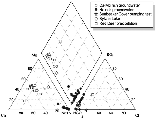
Precipitation is Ca–Mg rich, but is distinctly more calcium rich than lake water. The anion composition of the groundwater is dominantly bicarbonate, with a minor tendency towards sulphate enrichment occurring in the Na-rich groundwater group. No spatial trend was observed in the groundwater cation well water chemistry (i.e. Ca–Mg-rich groundwater vs. Na-rich groundwater; Figure ).
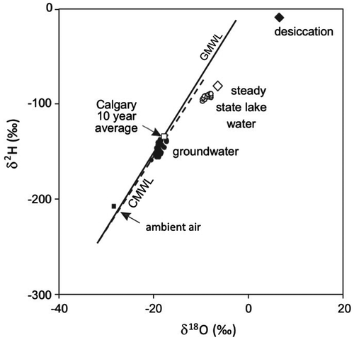
Oxygen and hydrogen isotopes in groundwater plotted on the local meteoric water line, while samples from the lake plotted below the local meteoric water line, which is indicative of evaporation (Gonfiantini Citation1986) (Figure ). The δ18O values in the lake water ranged from −9.21 to −9.04 ‰, while δD values ranged from −95.3 to −92.0 ‰. Groundwater δ18O values ranged from −20.6 to −17.4 ‰ and δD values ranged from −159 to −137 ‰. These are consistent with regional values for the Paskapoo Formation groundwater (Grasby et al. Citation2010), and slightly lower than average annual precipitation (Peng et al. Citation2004). Oxygen and deuterium isotope values for ambient air, and desiccation, were also calculated. The calculated ambient air isotopic value falls close to the meteoric water line, while the value for the lake falls along the local evaporative line, consistent with Gibson et al. (Citation2002).
Figure 6. Graph of δ18O versus δ2H showing global meteoric water line (GMWL, solid line) and the Calgary meteoric water line (CMWL, dashed) and Calgary 10-yr weighted average precipitation (Peng et al. Citation2004), groundwater (filled symbols), lake water (open symbols), calculated ambient isotopic composition of air, calculated steady state isotopic composition of lake, and calculated isotopic composition of desiccated lake water.
Lake water balance
Estimates of groundwater discharge into the lake from the channel sandstone calculated using the Darcy’s Law method range from less than 1 × 10⁶ m3/yr to more than 40 × 106 m3/yr. This large range is primarily related to the uncertainty in the estimates of the cross-sectional area of the channel that is hydraulically connected to the lake (i.e. ‘A’ in Equation Equation1(1) ). This may be as small as 2000 m2 (100 m length, 20 m thickness) or as large as 260,000 m2 (the entire length of the lake, 20 m thickness). Thus, the error in estimation of the cross-sectional channel sandstone area is comparable to, or even higher than, that of the hydraulic conductivity (typically considered to be an order of magnitude or two; Freeze and Cherry Citation1979). An additional, but likely much smaller, source of error may stem from the gradient calculations. It is possible that the gradients obtained from the deeper piezometers represent apparent gradients that are less than the true gradient if the deep groundwater flow direction is not directed towards Sylvan Lake. Although this may be the case, the resulting estimates of flow could be considered conservative as the true groundwater gradient would be greater and therefore the resulting flow would also be greater.
Estimates of groundwater flux using the chloride mass balance method were 16.4 × 10⁶ m3/yr into the lake and 18.6 × 10⁶ m3/yr out of the lake (Table ). In comparison, estimates based on δ18O of groundwater flux into and out of the lake were 18.5 × 10⁶ and 20.7 × 10⁶ m3/yr respectively, and for δ2H estimated for flux into and out of the lake were 17.7 × 10⁶ and 19.8 × 10⁶ m3/yr respectively.
Table 3. Estimated average annual precipitation (P), evaporation (E), surface water runoff (R), and groundwater (GW) fluxes. All values are in 106 m3/yr unless otherwise noted. Precipitation and evaporation were obtained by multiplying values (in mm/yr) by lake area. Surface water runoff values (in mm/yr) were multiplied by the area of the drainage basin (not including the lake area). The mid-range, minimum and maximum ranges were calculated from lower, visually interpolated, and upper ranges of the contour maps for runoff and lake evaporation estimates. The 30-year normal precipitation value was used.
Discussion
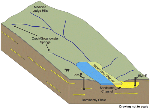
Based on well log analyses, in addition to observation of outcrops in the field, Sylvan Lake has an unusual geologic setting defined by a high-permeability channel sandstone that extends along most of the northeast shore line (Figure ). While the Paskapoo Formation underlies a large portion of central Alberta, sand channels are volumetrically minor, such that most lakes overlying this formation would be in connection with low-permeability shales. This setting allows Sylvan Lake an anomalously high degree of groundwater connection compared to most other lakes in the region. Active groundwater flux through the sand channel is indicated by iron oxide staining observed along fractures in core, suggesting recently infiltrated (i.e. oxygenated) groundwater flow. In contrast, the surrounding shales act as leaky confining layers where the groundwater flux is much lower. Shallow groundwater tends to be calcium and magnesium rich, suggesting local recharge (i.e. infiltration of precipitation through calcium- and magnesium-rich surficial tills), while deeper groundwater is sodium rich, suggesting a longer flow path or recharge through sulphide-rich till (Grasby et al. Citation1997, Citation2010).
Figure 7. Conceptual model of Sylvan Lake watershed showing channel sandstones (yellow) in the predominantly shale (brown) bedrock of the Paskapoo Formation.
The Darcy flux estimates were within the same order of magnitude as a previous estimation (AXYS Citation2005). The estimates of groundwater flux that were obtained from the Darcy’s Law method also showed the widest range of results. The least reliable parameter in this estimation was the cross-sectional area of the channel that intersects the lake, which varied by 40-fold. The inherent error in this estimation stems from uncertainty related to driller’s water well records (i.e. in the non-research wells), but also to the interpretive nature of developing a cross-section. For example, the water well records were often only located to the centre of the quarter section (0.64 km2 area) and therefore the elevation, which was estimated from the digital elevation model (DEM), can be off by as much as a few metres. Secondly, a driller’s descriptions of lithology may vary from driller to driller, which was challenging in interpreting and correlating lithology. Since the hydraulic gradients were also very low, small variations in their estimation will have a significant impact on the resulting discharge. The error in the Darcy flux method is substantial, but provides an additional estimate to complement the water isotope and chloride mass balances. While the results from the Darcy method are not discriminating, they are in agreement with the estimates obtained from the water isotope and chemical mass balance methods.
The results from the water isotope and chloride mass balance estimates of groundwater flux indicate that precipitation (23.7 × 10⁶ m3/yr) and evaporation (27.4 × 10⁶ m3/yr) are the dominant fluxes into and out of the lake (Table ). By including upper and lower limits to the input parameters, evaporation and runoff, the resulting range of mass balance estimates provide upper and lower limits of the estimated fluxes of groundwater. The range of estimates of groundwater inflow (14.0 to 19.3 × 10⁶ m3/yr) and groundwater outflow (15.9 to 20.7 × 10⁶ m3/yr) are similar from all three methods. These groundwater fluxes resulted in an estimated net groundwater contribution (i.e. groundwater flux into the lake minus that out of the lake) out of the lake, which was about −2.2 × 10⁶ m3/yr.
In one previous study the net groundwater contribution to the lake was estimated to be close to zero (Figliuzzi Citation1993), while another study estimated the net groundwater flux (as a residual term) to be anywhere from −8.2 × 10⁶ m3/yr to 8.1 × 10⁶ m3/yr (EBA Engineering Citation1976).
While the resulting net groundwater flux (i.e. inflow minus outflow) is relatively small (i.e. about 4% of the total input per year; Table ), the chloride mass balance implies that the relative groundwater fluxes (inflow and outflow) may have a significant impact on the resulting chemical lake water budget. In particular, the combination of groundwater outflow rates with an average lake chloride concentration of 2 mg/L suggests between 32 and 41 tons/yr of chloride are lost from the lake via groundwater discharge.
A groundwater flux into a lake can also serve as a means of lowering and stabilising the overall lake water temperatures, and groundwater flux out of a lake is a means of mass transport for lake water that would otherwise become enriched in TDS through evaporation. Thus, given the lack of a significant surface water outlet and the net evaporation deficit, Sylvan Lake would tend towards being an endorheic, or evaporating, lake in the absence of groundwater through-flow.
While more value might be assigned to the chloride and water isotope mass balances (since they rely on the estimation of fewer parameters to obtain water balance fluxes), good agreement with independent, physically based estimates lends additional confidence to the resulting fluxes. In particular, it is ideal to include physical and tracer-based methods. Each method has varying strengths and weaknesses related to issues of scale or assumptions made in the conceptual model, and their combined use makes the consequent estimates more robust.
Comparison to groundwater interaction in other Alberta prairie subregion lakes
Pine and Gull lakes, situated in the same natural subregion (Casey Citation2011) and also over Paskapoo Formation bedrock, have much in common with Sylvan Lake. For example, both have similar climatic conditions, and surficial sediments consisting of glacial tills overlying the Paskapoo Formation. However, although they have similar geologic and climatic settings to Sylvan Lake, and may have groundwater inputs, they are eutrophic as opposed to mesotrophic (Figure ) and have higher TDS (~450 mg/L for Pine Lake, and 700 mg/L for Gull Lake). An integrated study of groundwater flux, similar to the study done here on Sylvan Lake, was completed for the oligotrophic to mesotrophic Narrow Lake (Shaw et al. Citation1990) in a geologically distinct region in north-central Alberta. The integrated approach included using direct measurement of seepage with mini-piezometers, and seepage meters, Darcy’s Law calculations, ion and water mass balances, and a mathematical model. The study concluded that shallow groundwater flux into the lake was approximately 30% of total inputs to the lake and that groundwater outflow occurred in the deeper offshore portions of the lake. The groundwater flow regime described for Narrow Lake is similar to the groundwater flow regime suggested by this study with groundwater inflow at Sylvan Lake representing between 32 and 39% of total water inputs. Narrow Lake and Sylvan Lake are 2 and 3 times as deep, respectively, as Pine and Gull lakes (which are eutrophic; Figure ). It is possible that the groundwater outflow from Narrow Lake and Sylvan Lake has an influence on the trophic status that is not found in Pine Lake or Gull Lake.
Implications
The contribution of groundwater to the total Sylvan Lake water budget (~32 to 39% of input and 37 to 43% of output; Table ) is larger than the mean values found for 127 lakes worldwide (25% and 37% respectively; Rosenberry et al. Citation2015). The same authors found a strongly negative relationship between the percentage contribution of groundwater to lake water budgets and lake area, which suggested lakes similar in size to Sylvan Lake (42.8 km2) tended to have a groundwater contribution of around 15 or 20%. The relatively high groundwater contribution in Sylvan Lake relative to other lakes its size may be a result of its unique hydrogeological setting.
Given an annual estimated groundwater flux into the lake of 14.0 × 10⁶ to 18.5 × 10⁶ m3/yr, and the total volume of water in the lake (412 × 106 m3), the average groundwater residence time estimated using this particular method ranges from 22 to 30 years. This residence time is significantly less than has previously been estimated for Sylvan Lake (e.g. greater than 100 years [Casey Citation2011], based on a lumped net groundwater component in their water mass balance close to zero). While the lump-sum groundwater component in Sylvan Lake is close to zero (i.e. the volume of groundwater flowing into the lake is comparable to that flowing out of the lake), the actual values for groundwater inflow and outflow are significantly different from zero. Although it is not uncommon to use a lumped net groundwater term (Birks and Remenda Citation1999; van der Kamp et al. Citation2008; Roy and Hayashi Citation2008), the lumped term does not take into account the effect that groundwater through-flow can have on the geochemistry, chemical mass balance and overall water quality.
This significant component of groundwater through-flow likely plays a part in maintaining the anomalously low TDS and trophic status of Sylvan Lake as compared to other central Alberta Lakes (Figure ). The relatively small but consistent flushing out of Sylvan Lake by groundwater removes an estimated 32 to 41 tons/yr of chloride, offsetting the salinisation effects that would otherwise be expected from evaporation. The cooler groundwater entering the lake also helps maintain lower lake water temperatures.
A key finding of this work is that the relatively unique hydrogeological setting (i.e. a groundwater-connected channel sandstone aquifer along one edge of the lake) provides about one-third of the inflow to the lake’s water budget. Thus, although a volumetrically minor component of the bedrock formation, where they occur, channel sandstones can have a significant impact on surface water systems. This has significant implications for land-use practices. Because of the groundwater and lake water interaction along the channel sandstone aquifer, groundwater contamination emanating from land use over the sandstone aquifer may have a more direct impact on the lake water quality and land use should be considered carefully.
Conclusions
The groundwater contribution to the lake water balance at Sylvan Lake, Alberta was investigated using multiple approaches that included two mass balance methods (chloride and water isotopes), and a Darcy’s Law method. The methods in this study are adaptable to a variety of lake settings for analysis of regional groundwater flow regime because they are economical, and do not require expensive instrumentation.
The major findings of this work are:
| (1) | A large-scale channel sandstone that extends along the north side of Sylvan Lake provides significant groundwater interaction along the northeast margin of Sylvan Lake. | ||||
| (2) | Two independent mass balance approaches suggested 37 to 43% of the annual lake water input was groundwater, resulting in lake residence time estimates of 22 to 30 years, and were consistent with the physically based Darcy’s Law approach. These mass balance calculations would not have been possible without a strong understanding of the geology and hydrogeology in the watershed in order to develop a representative conceptual model that included physically based groundwater flux estimates. | ||||
| (3) | Although the net groundwater flux is small, and does not affect the water balance significantly, the solutes lost in the total groundwater outflow are important, and contribute to the regionally anomalous low TDS and trophic status of Sylvan Lake. | ||||
| (4) | Due to the hydraulic connection of the sandstone channel with Sylvan Lake, land use along the north side of the lake (i.e. above the channel) could have a more direct impact on the lake water quality than development elsewhere around the lake and should be carefully considered. | ||||
| (5) | The use of a lumped sum net groundwater term in a lake water balance must be evaluated with respect to the water quality in a through-flow lake setting. | ||||
Funding
This work was supported by the Natural Sciences and Engineering Research Council of Canada.
Acknowledgements
We appreciate the support for the project by the following: Hydrogeological Consultants Limited, Town of Sylvan Lake, Alberta Environment and Parks, Natural Sciences and Engineering Research Council of Canada, Prairie Farm Rehabilitation Administration, Sylvan Lake Stewardship Society, and a private landowner at Sunbreaker Cove.
References
- Almendinger, J. E. 1990. Groundwater control of closed-basin lake levels under steady-state conditions. Journal of Hydrology 112 (3-4): 293–318.10.1016/0022-1694(90)90020-X
- ALMS (Alberta Lakes Management Society). 2010. LakeWatch: 2010 Sylvan Lake Report. 13pp. https://slwssnews.files.wordpress.com/2012/11/2010-lakewatchreport-sylvanlake.pdf ( accessed August 2017).
- Appelo, C. A. J., and D. Postma. 1996. Geochemistry, Groundwater and Pollution. Rotterdam/Brookfield: AA Balkema Publishers.
- AXYS Environmental Consulting Ltd. 2005. Sylvan Lake Water Quality Assessment and Watershed Management Considerations, 441 pp.
- Baker, J. 2009. Groundwater Contribution to Sylvan Lake, Alberta, Canada. Unpublished M.Sc Thesis. University of Calgary, 111 pp.
- Bell, S., and S. E. Grasby. 2011. The stress regime of the western Canadian sedimentary basin. Geofluids 12: 150–165.
- Birks, S. J., and V. N. Remenda. 1999. Hydrogeological investigation of Chappice Lake, southeastern Alberta: Groundwater inputs to a saline basin. Journal of Paleolimnology 21 (2): 235–255.10.1023/A:1008041810022
- Burns, E. D., L. R. Bentley, M. Hayashi, S. E. Grasby, A. P. Hamblin, and D. G. Smith. 2010. Hydrogeological implications of paleo-fluvial architecture for the Paskapoo formation, SW Alberta, Canada: A stochastic analysis. Hydrogeology Journal 18: 1375–1390.10.1007/s10040-010-0608-y
- Casey, R. 2011. Water Quality Conditions and Long-Term Trends in Alberta Lakes. Alberta Environment and Water, Report 1102, Alberta Environment and Water. Edmonton. 419 pp + Appendix (6p).
- Chen, Z., S. E. Grasby, and K. G. Osadetz. 2011. Geological controls on regional transmissivity anisotropy. Geofluids 11: 228–241.10.1111/gfl.2011.11.issue-2
- Craig, H., and L. I. Gordon. 1965. Deuterium and oxygen 18 variations in the ocean and the marine atmosphere. In Stable isotopes in oceanographic studies and paleotemperatures. Consiglio nazionale delle richerche, Laboratorio de geologia nucleare.
- Crosby, J.M. 1990. Sylvan Lake. In The Atlas of Alberta Lakes, eds. P. Mitchell and E.E. Prepas. University of Alberta Press. http://albertalakes.ualberta.ca/ ( accessed August 2017).
- Engineering, E. B. A. 1976. The Ground-Water Effects of Lowering and Stabilization of Sylvan Lake. Alberta: Prepared for Alberta Environment.
- Environment, Alberta. 2005. Median Annual Unit Runoff. Technical Services Division, Hydrology. Edmonton, AB.
- Environment Canada. 2005. Canadian National Atmospheric Database; Precipitation Water Quality Monitoring Program in Alberta. Alberta, Canada: Environment Canada.
- Environment Canada. 2007. Canadian Climate Normals 1971–2000. Ottawa, ON: Environment Canada.
- Figliuzzi, S. J. 1976. Sylvan Lake Hydrological Study. Edmonton AB: Prepared for Alberta Department of the Environment.
- Figliuzzi, S. J. 1993. Sylvan Lake Study of Regulation by Outlet Control Structure. Edmonton AB: Prepared for Alberta Environmental Protection.
- Freeze, A. R. and J. A. Cherry. 1979. Groundwater. Prentice-Hall, 604 pp.
- Gabert, G. M. 1975. Hydrogeology of Red Deer and the Vicinity, Alberta. Edmonton: Alberta Research Council, 104pp.
- Gibson, J. J., E. E. Prepas, and P. McEachern. 2002. Quantitative comparison of lake throughflow, residency, and catchment runoff using stable isotopes: Modelling and results from a regional survey of Boreal lakes. Journal of Hydrology 262 (1-4): 128–144.10.1016/S0022-1694(02)00022-7
- Gibson, J. J., S. J. Birks, Y. Yi, M. C. Moncur, and P. M. McEachern. 2016. Stable isotope mass balance of fifty lakes in central Alberta: Assessing the role of water balance parameters in determining trophic status and lake level. Journal of Hydrology: Regional Studies 6: 13–25.
- Gonfiantini, R. 1986. Environmental Isotopes in Lake Studies. In Handbook of Environmental Isotope Geochemistry, ed. M. Baskaran, 113–168. New York, NY: Elsevier.
- Government of Canada. 2017. Mean Annual Calculated Lake Evaporation: Alberta. http://open.canada.ca/data/en/dataset/67de4f04-855d-5d23-bb4a-2a270d1488d0 ( accessed August 4, 2017).
- Grasby, S. E., I. Hutcheon, and H. R. Krouse. 1997. Application of the stable isotope composition of sulfate to tracing anomalous TDS in Nose Creek, southern Alberta, Canada. Applied Geochemistry 12: 567–575.10.1016/S0883-2927(97)00014-0
- Grasby, S. E., I. Hutcheon, and L. McFarland. 1999. Surface-water-groundwater interaction and the influence of ion exchange reactions on river chemistry. Geology 27 (3): 223–226.10.1130/0091-7613(1999)027<0223:SWGIAT>2.3.CO;2
- Grasby, S. E., Z. Chen, A. P. Hamblin, P. R. J. Wozniak, and A. R. Sweet. 2008. Regional characterization of the Paskapoo bedrock aquifer system, southern Alberta. Canadian Journal of Earth Sciences 45 (12): 1501.10.1139/E08-069
- Grasby, S. E., J. Osborn, Z. Chen, and P. Wozniak. 2010. Influence of till provenance on regional groundwater geochemistry. Chemical Geology 273: 225–237.10.1016/j.chemgeo.2010.02.024
- Hagerthey, S. E., and W. C. Kerfoot. 2005. Spatial variation in groundwater-related resource supply influences freshwater benthic algal assemblage composition. Journal of the North American Benthological Society 24 (4): 807–819.10.1899/04-004.1
- Hood, J. L., J. W. Roy, and M. Hayashi. 2006. Importance of groundwater in the water balance of an alpine headwater lake. Geophysical Research Letters 33 (13): 303.10.1029/2006GL026611
- Iwanyshyn, M. I., M. C. Ryan, and A. Chu. 2008. Separation of physical loading from photosynthesis/respiration processes in rivers by mass balance. Science of the Total Environment 390: 205–214.10.1016/j.scitotenv.2007.09.038
- van der Kamp, G., D. Keir, and M. S. Evans. 2008. Long-term water level changes in closed-basin lakes of the Canadian Prairies. Canadian Water Resources Journal 33 (1): 23–38.10.4296/cwrj3301023
- Kluge, T., C. von Rohden, P. Sonntag, S. Lorenz, M. Wiesser, W. Aeschbach-Hertig, and J. Ilmberger. 2012. Localising and quantifying groundwater inflow into lakes using high-precision 222Rn profiles. Journal of Hydrology 450-451: 70–81.10.1016/j.jhydrol.2012.05.026
- Kruseman, G. P., and N. A. de Ridder. 1990. Analysis and Evaluation of Pumping Test Data. 2nd ed. Wagenoingen, Netherlands: International Institute for Land Reclamation and Improvement.
- Majoube, M. 1971. Fractionnement en oxygene-18 et en deuterium entre l’eau et sa vapeur. Journal de Chimie Physique et de Physico-Chimie Biologique 68: 1423–1436.10.1051/jcp/1971681423
- Moran, J. M., and M. D. Morgan. 1991. Meteorology: The Atmosphere and the Science of Weather. New York, NY: Macmillan Publishers.
- Peng, H., B. Mayer, S. Harris, and H.R. Krouse. 2004. A 10 yr record of stable isotope ratios of hydrogen and oxygen in precipitation at Calgary, Alberta, Canada. Tellus 56: 147–159.10.3402/tellusb.v56i2.16410
- Rosenberry, D. O., J. Lewandowski, K. Meinikmann, and G. Nützmann. 2015. Groundwater - the disregarded component in lake water and nutrient budgets. Part 1: Effects of groundwater on hydrology. Hydrological Processes 29 (13): 2895–2921.10.1002/hyp.v29.13
- Roy, J. W., and M. Hayashi. 2008. Groundwater exchange with two small alpine lakes in the Canadian Rockies. Hydrological Processes 22: 2838–2846.10.1002/hyp.v22:15
- Shaw, R. D., and E. E. Prepas. 1990. Groundwater-lake interactions: I. Accuracy of seepage meter estimates of lake seepage. Journal of Hydrology 119: 105.10.1016/0022-1694(90)90037-X
- Shaw, R. D., J. F. H. Shaw, H. Fricker, and E. E. Prepas. 1990. An integrated approach to quantify groundwater transport of phosphorus to Narrow Lake, Alberta. Limnology and Oceanography 35 (4): 870–886.10.4319/lo.1990.35.4.0870
- Shaw, G. D., E. S. White, and C. H. Gammons. 2013. Characterizing groundwater – lake interactions and its impact on lake water quality. Journal of Hydrology 492: 69–78.10.1016/j.jhydrol.2013.04.018
- Shetson, I. 1990. Quaternary Geology, Central Alberta. Edmonton, Alberta: Alberta Geological Survey.
- Winter, T. C. 1999. Relation of streams, lakes, and wetlands to groundwater flow systems. Hydrogeology Journal 7 (1): 28–45.10.1007/s100400050178