
Groundwater is a crucial supply of freshwater worldwide. It is estimated that groundwater represents more than one third of water withdrawals used for irrigation, domestic, and manufacturing purposes (Döll et al. Citation2012). In Canada, about 30% of the population (nearly 10 million inhabitants) depend on groundwater for their water supply (CCA Citation2009). In the Province of Quebec, 20% of the population relies on groundwater for its drinking water over 90% of the inhabited territory (MDDELCC Citation2018).
Globally, several pressures impact the state of groundwater resources, including urbanization, land and water uses, pollution and climate variability (WWAP Citation2009). The intensification of industrial and agricultural activities, that can lead to contamination and overexploitation, as well as natural climate variability and climate change, are threats to Canada’s groundwater (Rivera et al. Citation2004; CCA Citation2009). It has been recognized at different levels of organizations that the lack of knowledge on groundwater resources and aquifers, as well as the difficulty in accessing water-related data, are major obtacles to the implementation of sustainable management of groundwater resources (Government of Québec Citation2002; CCA Citation2009; WWAP Citation2009).
To face this challenge in the Province of Quebec, a unique and systematic program of regional hydrogeological mapping, the Groundwater Knowledge Acquisition Program (Programme d’acquisition de connaissances sur les eaux souterraines – PACES), was implemented in 2008 by the Québec Ministry of the Environment (Ministère du Développement durable, de l’Environnement et de la Lutte contre les changements climatiques – MDDELCC) to ensure the protection and long-term sustainability of groundwater resources (MDDELCC Citation2018). The proposed methodology for the PACES program was based on the experience developed during previous hydrogeological mapping projects in Quebec (pre-PACES projects; Figure ), including the Portneuf granular aquifers (Fagnan et al. Citation1999), the Basses-Laurentides fractured aquifer system (Savard Citation2013), and the Châteauguay River Watershed (Nastev and Lamontagne Citation2010), as well as the Basse and moyenne-Chaudière agricultural region (Tecsult Citation2008).
Figure 1. Location of completed and current groundwater characterization projects in the Province of Quebec. The map illustrates the pre-PACES (projects funded through the Programme d'acquisition de connaissances sur les eaux souterraines): PORT (dark grey) – Portneuf, AFSOQ – Basses-Laurentides, CHAT – Châteauguay, and CHAUD-A (dark grey) – Basse-Chaudière; the PACES projects completed between 2009 and 2015 from 2009 to 2015: AT1 and AT2 – Abitibi-Témiscamingue-1 and -2, BEC – Bécancour, BSL – Bas-Saint-Laurent, CN – Charlevoix-Haute-Côte-Nord, CHAUD-A (light grey) – Chaudière-Appalaches, CMQ – Communauté métropolitaine de Québec, MAUR – Mauricie, MONT – Montérégie-Est, NSF – Nicolet-Saint-François, OUT – Outaouais, SLSJ – Saguenay-Lac-Saint-Jean, VS – Vaudreuil-Soulanges; and the current PACES projects that started in 2018: KRT – Bas-Saint-Laurent-Témiscouata, ESTR – Estrie, LAUR-M – Laurentides, LANAU – Lanaudière, MAUR-E – Mauricie-Est, and PORT (hatched) – Portneuf).
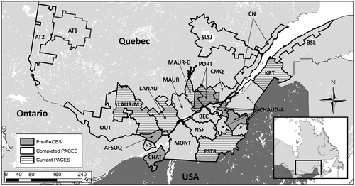
The general objective of the PACES was to provide an integrated portrait of the groundwater resources of Quebec’s municipal regions, in terms of both groundwater quantity and quality, to better protect and sustainably manage groundwater resources. A total of 13 regional hydrogeological mapping projects of PACES were completed during the 2009–2015 period (Abitibi-Témiscamingue-1 and -2, Bécancour, Bas-Saint-Laurent, Charlevoix-Haute-Côte-Nord, Chaudière-Appalaches, Communauté métropolitaine de Québec, Mauricie, Montérégie-Est, Nicolet-Saint-François, Outaouais, Saguenay-Lac-Saint-Jean, Vaudreuil-Soulanges; Figure ). These projects were led by research teams from seven Quebec universities (Institut national de la recherche scientifique centre Eau Terre Environnement – INRS-ETE; Université Laval; Université du Québec à Chicoutimi – UQAC; Université du Québec à Montréal – UQAM; Université du Québec à Rimouski – UQAR; Université du Québec en Abitibi-Témiscamingue – UQAT; and Université du Québec à Trois-Rivières – UQTR), in collaboration with regional stakeholders (e.g. Regional Conference of Elected Officials, Conférence régionale des élus – CRÉ); regional county municipalities, Municipalités régionales de comtés – MRC; watershed organizations, Organismes de bassins versants – OBV), and provincial (Ministry of Ariculture, Ministère de l’Agriculture, des Pêcheries et de l’Alimentation – MAPAQ; Ministry of Energy and Natural Ressources, Ministère de l’Énergie et des Ressources naturelles – MERN) and federal (Natural Resources Canada) partners. A unique and efficient inter-university collaborative approach was developed to share equipment and services, co-supervise graduate students, and develop common protocols, from field data acquisition to map production (Palmer et al. Citation2011). All the PACES projects thus used uniform databases and similar methodologies for the development of thematic maps, allowing comparisons between regions. Four new PACES projects were initiated in 2018, with funding from the MDDELCC, and will use the same methodology, thus completing the territory coverage in many regions of the Quebec Province (Figure ).
The collaborative approach between university researchers led to the creation in 2011 of the Quebec Groundwater Network (Réseau québécois sur les eaux souterraines – RQES; www.rqes.ca). The mission of the RQES is to consolidate and extend collaborations between university researchers and the Québec Ministry of the Environment, and other governmental and non-governmental organizations, consultants, educational institutions and additional organizations interested in groundwater, with the objective of facilitating groundwater knowledge transfer to water managers. The PACES projects allowed an unprecedented regional-scale groundwater characterization of southern Quebec. Nevertheless, despite this major advance, the adequate integration and use of the hydrogeological information in land management remains a challenge, due to the complexity related to data and map interpretation and to the lack of dedicated knowledge transfer initiatives. To face this critical issue, the RQES developed a knowledge exchange strategy that is based on a series of interactive workshops undertaken in all the PACES regions. These workshops helped to optimize the adequate use of quantitative hydrogeological data in land management with the objective of better protecting groundwater resources (Ruiz Citation2016).
The purpose of this special issue is to bring together a sample of the vast new knowledge that was created by the PACES projects across the Province of Quebec between 2009 and 2015. Many of the scientists who were involved in these projects responded positively to the invitation. This special issue contains 10 contributions from university researchers and private consultants on relevant topics such as aquifer geometry and hydraulic properties, hydrogeochemistry and isotopic tracers, residence times, and groundwater flow modelling.
The studied PACES regions are distributed over a large area of the meridional portion of the Province of Quebec (Figure ). The territory has highly diversified geology and contrasting climate conditions, thus influencing the hydrogeology of the studied regions. The projects cover three hydrogeolocal regions of Canada described by Rivera (Citation2014): (1) the Precambrian Shield, (2) the St. Lawrence Lowlands, and (3) the Appalachians. These hydrogeological regions correspond to important geological domains of Québec, i.e. the Superior and Grenville provinces, the St. Lawrence Platform, and the Appalachian Province. The last glaciation/deglaciation cycle, with the deposition of unconsolidated sediments, the formation of proglacial lakes and marine invasions, had major impacts on the shaping of the landscape, as well as on the hydrogeology and hydrogeochemistry of the aquifer systems. Details of these geological contexts are presented in the 10 articles. The papers focus on three main components of aquifer characterization, i.e. aquifer geometry (Légaré-Couture et al. Citation2018; Nadeau et al. Citation2018; Walter et al. Citation2018), hydrogeochemistry and isotope tracers (Chaillou et al. Citation2018; Rey et al. Citation2018; Beaudry et al. Citation2018), and groundwater flow modeling and particle tracking (Gagné et al. Citation2018; Janos et al. Citation2018; Montcoudiol et al. Citation2018; Turgeon et al. Citation2018). The paper by Walter et al. (Citation2018) combines the topics of geometry and hydrogeochemistry.
In their characterization of the major aquifer systems in the Saguenay–Lac-Saint-Jean region (SLSJ), Walter et al. (Citation2018) provide a comprehensive overview of the three phases of a PACES project and of their outcomes, including defining the aquifer systems, quantifying the hydrogeological properties, and characterizing groundwater quality in a complex graben environment. The authors used their results to develop a conceptual model of regional hydrostratigraphic features and groundwater quality of the major aquifers in support of sustainable management of regional groundwater ressources. Légaré-Couture et al. (Citation2018) propose a methodology for building a three-dimensional (3D) hydrostratigraphical model of the Quaternary deposits to define the main hydrogeological contexts of granular aquifers that provide important water supplies for most municipalities of the Mauricie region (MAUR). Based on this model, the authors identified four main hydrostratigraphic units for the study area. This refined the understanding of regional aquifers and contibuted to the identification of unexploited aquifers around the Saint-Narcisse morainic complex and along the Saint-Cuthbert Fault. Also focusing on groundwater resources within unconsolidated aquifers, Nadeau et al. (Citation2018) describe a newly developed GIS-based approach facilitating the development of a stratigraphic sequence map for representing the architecture of aquifer–aquitard systems at the regional scale in Abitibi-Témiscamingue regions 1 and 2 (AT1 and AT2). The resulting stratigraphic sequence map was used to document the extent and volume of regional aquifers, as well to build a conceptual model of regional groundwater flow paths. The authors also dicussed the potential contibutions of the stratigraphic sequence map as a tool to support political decision makers facing issues related to groundwater resource protection and sustainable development.
Chaillou et al. (Citation2018) present a regional groundwater hydrogeochemical portrait of the Bas-Saint-Laurent region (BSL). The contrasting geology of this region comprises the Appalachians and glacial Quaternary deposits set in close proximity to the coastal environment of the St. Lawrence estuary. The authors used major and trace ions, as well as stable isotopes of water and inorganic carbon, to identify seven water facies. They proposed a conceptual model of groundwater flow to explain the hydrogeochemical evolution at the regional scale. Interestingly, their results suggest the absence of modern seawater in the samples despite the proximity of the St. Lawrence estuary. Different geological formations were studied by Beaudry et al. (Citation2018) in the Montérégie region including the St. Lawrence Lowlands, the Appalachian Piedmont and Uplands, and the Monteregian Hills (MONT). Similarly to Chaillou et al. (Citation2018), the authors used major and trace ions, stable isotopes of water and carbon, and 14C and 3H to identify the mechanisms controlling groundwater composition and to support the understanding of the aquifer hydrodynamics. Their results provide indications of recharge zones, groundwater flow zones and discharge zones. They also identified an extensive zone of brackish water originating from the Champlain Sea and located in the lower portion of the study area. CitationRey et al. (2017) focused on the Barlow-Ojibway Clay Belt of the Abitibi-Témiscamingue region which includes many esker and moraine aquifers (AT1 and AT2). They used stable isotopes of water and 3H to improve the understanding of the regional groundwater flow system. The results were used to build a regional-scale conceptual model which describes recharge, evaporation, mixing and discharge processes.
Gagné et al. (Citation2018) present a 3D model of groundwater flow for the Bécancour and Nicolet watersheds in the Centre-du-Québec region (BEC and NSF). In this region, the main aquifer is located in the sedimentary fractured bedrock and is overlain by till, sand and clay from the Champlain Sea. The spatially distributed recharge was simulated independently with a surface water budget approach. The steady-state MODFLOW model (Harbaugh Citation2005) was calibrated using measured heads and baseflows with PEST (Doherty Citation2015). The authors have shown that isotope-derived groundwater travel times and major ion chemistry can be used to validate the model. Janos et al. (Citation2018) developed a vertical 2D steady-state flow model with the FLONET/TR2 numerical code (Molson and Frind Citation2017), and calibrated it with PEST using measured heads for the Chaudière-Appalaches region (CHAUD-A). The model simulated groundwater ages that were used to show that the area is dominated by local-scale flow systems, thus confirming the conceptual model identified using hydrogeochemical variables. The authors also investigated the role of faults in disturbing groundwater age patterns. Montcoudiol et al. (Citation2018) also used the FLONET/TR2 numerical code to simulate 2D steady-state groundwater flow, in the fractured bedrock of the Canadian Shield overlain by sand, gravel and clay in the Outaouais region (OUT). Their model was calibrated using heads and measured 3H values and helped to validate and update a conceptual model of geochemical evolution. Turgeon et al. (Citation2018) used the integrated MikeSHE flow model (DHI Citation2007) to simulate transient-state groundwater and surface water interactions in the Raquette River watershed of the Vaudreuil-Soulanges region (VS). The complex geology of the watershed is composed of sedimentary bedrock and of the Rigaud Monteregian Hill, with till and thick sand and clay deposits. The model was calibrated using river flow rates and heads and provided a good insight into the watershed surface and groundwater flow. The authors identified areas for possible improvement in the model, notably the explicit simulation of infiltration processes in the unsaturated zone.
The papers in this special issue do not address all the topics covered in the PACES projects. Many other papers have been published in different journals on a wide array of groundwater-related issues derived directly from the PACES projects or closely linked to them. In terms of physical hydrogeology, the PACES-related studies allowed the development of methods to assess groundwater recharge (e.g. Gosselin et al. Citation2016; Huet et al. Citation2016), to estimate transmissivity from specific capacity data (e.g. Richard et al. Citation2015; Laurencelle and Lefebvre Citation2018) and to improve the spatial analysis of piezometric data (e.g. Tremblay et al. Citation2015). Other studies allowed better highlighting of the role of groundwater in river flow or peatland-aquifer interactions (e.g. Ferlatte et al. Citation2015; Rosa et al. Citation2018). The use of groundwater geochemistry further allowed assessment of chemical evolution of groundwater along flowpaths (e.g. Ghesquière et al. Citation2015; Montcoudiol et al. Citation2015) and deciphering the processes influencing the occurrence of geogenic arsenic in fractured bedrock aquifers (e.g. Bondu et al. Citation2017). Other studies examining groundwater geochemistry focused on evaluating groundwater vulnerability (e.g. Meyzonnat et al. Citation2016) and documenting the concentrations of emerging contaminants such as pesticides and pharmaceutically active compounds in groundwater (e.g. Saby et al. Citation2017). Studies focusing on the use of GIS further allowed the development of a method for supporting groundwater protection in unconfined granular aquifers (e.g. Nadeau et al. Citation2015), as well the development of sustainable groundwater resource indicators to support knowledge transfer initiatives (Lefebvre et al. Citation2016). Moreover, the PACES projects have provided large databases and new knowledge about Québec aquifers. Many challenges now arise including, for example, how to maintain up-to-date databases, how to monitor groundwater quality and quantity over the long term, and how changing climate conditions and changing land use will impact groundwater resources. Research is ongoing in many of these domains.
We believe that this special issue provides a valuable snapshot of the current, state-of-the-art knowledge on groundwater resources in the Province of Quebec. It summarizes new knowledge on groundwater availability, groundwater flow conditions, aquifer recharge and groundwater quality in this part of Canada. It also presents a portrait of state-of-the art methods for aquifer characterization and how they can be used in different geological settings. It is our hope that this special issue will be a reference for hydrogeologists across the country and motivate the initiation of new research for a better understanding of our groundwater resources.
Acknowledgements
This special issue has brought together scientists who were involved in the recent Groundwater Knowledge Acquisition Program. We wish to thank the authors who have contributed to advancing knowledge about groundwater resources in the Province of Quebec. We acknowledge the financial contribution of the Quebec Ministry of the Environment (Ministère du Développement durable, de l’Environnement et de la Lutte contre les changements climatiques) through the Groundwater Knowledge Acquisition Program (PACES), as well as the contribution of all the regional partners that were involved in the projects. We also thank the reviewers who have contributed to the high scientific level achieved by this special issue and all its comprising articles.
References
- Beaudry, C., R. Lefebvre, C. Rivard, and V. Cloutier. 2018. Conceptual model of regional groundwater flow based on hydrogeochemistry (Montérégie Est, Québec, Canada). Canadian Water Resources Journal. doi:10.1080/07011784.2018.1461579
- Bondu, R., V. Cloutier, É. Rosa, and M. Benzaazoua. 2017. Mobility and speciation of geogenic arsenic in bedrock groundwater from the Canadian Shield in western Quebec, Canada. Science of The Total Environment 574: 509–519.
- CCA (Council of Canadian Academies). 2009. The sustainable management of groundwater in Canada – The expert panel on groundwater. Report prepared for the Government of Canada, Council of Canadian Academies, Ottawa, 270 pp.
- Chaillou, G., M. Touchette, T. Buffin-Bélanger, C. A. Cloutier, B. Hétu, and M. A. Roy. 2018. Hydrogeochemical evolution and groundwater mineralization of shallow aquifers in the Bas-Saint-Laurent region, Québec, Canada. Canadian Water Resources Journal. doi:10.1080/07011784.2017.1387817.
- DHI. 2007. Mike SHE user manual, Volume 1: User guide. Horsholm: 904 Danemark. 396 p.
- Doherty, J. 2015. Calibration and Uncertainty Analysis for Complex Environmental Models. Brisbane, Australia: Watermark Numerical Computing.
- Döll, P., H. Hoffmann-Dobrev, F. T. Portmann, S. Siebert, A. Eicker, M. Rodell, G. Strassberg, and B. R. Scanlone. 2012. Impact of water withdrawals from groundwater and surface water on continental water storage variations. Journal of Geodynamics 59-60: 143–156.
- Fagnan, N., É. Bourque, Y. Michaud, R. Lefebvre, É. Boisvert, M. Parent, and R. Martel. 1999. Hydrogéologie des complexes deltaïques sur la marge nord de la mer de Champlain, Québec. Hydrogéologie 4: 9–22.
- Ferlatte, M., A. Quillet, M. Larocque, V. Cloutier, S. Pellerin, and C. Paniconi. 2015. Aquifer-peatland connectivity in southern Quebec (Canada). Hydrological Processes 29: 2600–2612.
- Gagné, S., M. Larocque, D. L. Pinti, M. Saby, G. Meyzonnat, and P. Méjean. 2018. Benefits and limitations of using isotope-derived groundwater travel times and major ion chemistry to validate a regional groundwater flow model: example from the Centre-du-Québec region, Canada. Canadian Water Resources Journal. doi:10.1080/07011784.2017.1394801.
- Ghesquière, O., J. Walter, R. Chesnaux, and A. Rouleau. 2015. Scenarios of groundwater chemical evolution in a region of the Canadian Shield based on multivariate statistical analysis. Journal of Hydrology: Regional Studies 4: 246–266.
- Gosselin, J. S., C. Rivard, R. Martel, and R. Lefebvre. 2016. Application limits of the interpretation of near-surface temperature time series to assess groundwater recharge. Journal of Hydrology 538: 96–108. doi:10.1016/j.jhydrol.2016.03.055.
- Government of Québec. 2002. Québec water policy. Bibliothèque nationale du Québec, ISBN 2-550-40076-3, Envirodoq ENV/2002/0310A, 94 p.
- Harbaugh, A. W. 2005. MODFLOW-2005, the U.S. Geological Survey modular ground-water model – The ground-water flow process: U.S. Geological Survey techniques and methods 6-A16. Various pp. http://pubs.usgs.gov/tm/2005/tm6A16/.
- Huet, M., R. Chesnaux, M. A. Boucher, and C. Poirier. 2016. Comparing various approaches for assessing groundwater recharge at the regional scale in the Canadian Shield. Hydrological Sciences Journal 61 (12): 2267–2283.
- Janos, D., J. Molson, and R. Lefebvre. 2018. Regional groundwater flow dynamics and residence times in Chaudière-Appalaches, Québec, Canada: Insights from numerical simulations. Canadian Water Resources Journal. doi:10.1080/07011784.2018.1437370.
- Laurencelle, M., and R. Lefebvre. 2018. Inferring regional-scale vertical profiles of fracture and hydraulic properties in a shallow rock aquifer system based on transmissivity data affected by well-drillers’ sampling bias. Abstract EGU2018-11325, EGU General Assembly 2018, Vienna, Austria, 8-13 April 2018.
- Lefebvre, R., C. Rivard, M.A. Carrier, M. Parent, M. Laurencelle, C. Beaudry, A. Martin, J. Bleser, R. Lavoie, É. Bourque, and M. Ouellet. 2016. Conceptual models and sustainable groundwater resource indicators as transfer tools to stakeholders of the Lake Champlain transboundary aquifer. Abstract EGU2016-10464, EGU General Assembly 2016, Vienna, Austria, 17-22 April 2016.
- Légaré-Couture, G., Y. Leblanc, M. Parent, K. Lacasse, and S. Campeau. 2018. Three-dimensional hydrostratigraphical modelling of the regional aquifer system of the St. Maurice Delta Complex (St. Lawrence Lowlands, Canada). Canadian Water Resources Journal. doi:10.1080/07011784.2017.1316215.
- MDDELCC (Ministère du Développement durable, de l’Environnement et de la Lutte contre les changements climatiques). 2018. Programme d’acquisition de connaissances sur les eaux souterraines. http://www.mddelcc.gouv.qc.ca/eau/souterraines/programmes/acquisition-connaissance.htm (accessed March, 2018).
- Meyzonnat, G., M. Larocque, F. Barbecot, D. L. Pinti, and S. Gagné. 2016. The potential of major ion chemistry to assess groundwater vulnerability of a regional aquifer in southern Quebec (Canada). Environ Earth Sciences 76: 1751. doi:10.1007/s12665-015-4793-9.
- Molson, J. W., and E. O. Frind. 2017. FLONET/TR2 user guide, a two-dimensional simulator for groundwater flownets, contaminant transport and residence time, Version 5. Waterloo, ON: Universite Laval and University of Waterloo, 57 p.
- Montcoudiol, N., J. W. Molson, J. M. Lemieux, and V. Cloutier. 2015. A conceptual model for groundwater flow and geochemical evolution in the southern Outaouais Region, Québec, Canada. Applied Geochemistry 58: 62–77.
- Montcoudiol, N., J. Molson, and J. M. Lemieux. 2018. Numerical modelling in support of a conceptual groundwater flow and geochemical evolution in the southern Outaouais Region Quebec, Canada. Canadian Water Resources Journal. doi:10.1080/07011784.2017.1323560.
- Nadeau, S., E. Rosa, B. Cloutier, R.-A. Daigneault, and J. Veillette. 2015. A GIS-based approach for supporting groundwater protection in eskers: Application to sand and gravel extraction activities in Abitibi-Témiscamingue, Québec, Canada. Journal of Hydrology: Regional Studies 4: 535–549.
- Nadeau, S., E. Rosa, and V. Cloutier. 2018. Stratigraphic sequence map for groundwater assessment and protection of uncosolidated aquifers: A case example in the Abitibi-Témiscamingue region, Québec, Canada. Canadian Water Resources Journal. doi:10.1080/07011784.2017.1354722.
- Nastev, M., and C. Lamontagne. 2010. Preface to the special issue on the hydrogeology of the Chateauguay River Watershed. Canadian Water Resources Journal 35 (4): 355–358.
- Palmer,S., S. Campeau, V. Cloutier, R. Daigneault, M. Larocque, R. Lefebvre, J.-M. Lemieux, J. Molson, C. Rivard, A. Rouleau, and R. Therrien. 2011. Collaborative approaches to groundwater knowledge acquisition in Québec: Inter-regional characterzation. Joint CANQUA/IAH-CNC Groundwater Conference, Québec, Canada, August 28-31, 2011, 6 p.
- Rey, N., E. Rosa, V. Cloutier, and R. Lefebvre. 2018. Using water stable isotopes for tracing surface and groundwater flow systems in the Barlow-Ojibway Clay Belt, Quebec, Canada. Canadian Water Resources Journal. doi:10.1080/07011784.2017.1403960.
- Richard, S. K., R. Chesnaux, A. Rouleau, and R. H. Coupe. 2015. Estimating the reliability of aquifer transmissivity values obtained from specific capacity tests: examples from the Saguenay-Lac-Saint-Jean aquifers, Canada. Hydrological Sciences Journal 61 (1): 173–185.
- Rivera, A., ed. 2014. Canada’s groundwater resources. Markham, ON: Fitzhenry & Whiteside. ISBN 978-1-55455-292-4, 824 p.
- Rivera, A, D. M. Allen, and H. Maathuis. 2004. Climate variability and change – Groundwater resources. Threats to water availability in Canada. NWRI Scientific Assessment Report Series No. 3, Environment Canada, 77–83 pp.
- Rosa, E., P.-L. Dallaire, S. Nadeau, V. Cloutier, J. Veillette, S. van Bellen, and M. Larocque. 2018. A graphical approach for documenting peatland hydrodiversity and orienting land management strategies. Hydrological Processes. doi:10.1002/hyp.11457.
- Ruiz, J. 2016. Le transfert des connaissances sur les eaux souterraines. Montréal: Réseau québécois sur les eaux souterraines.
- Saby, M., M. Larocque, D. L. Pinti, F. Barbecot, S. Gagné, D. Barnetche, and H. Cabana. 2017. Regional assessment of concentrations and sources of pharmaceutically active compounds, pesticides, nitrate, and E. coli in post-glacial aquifer environments (Canada). Science of The Total Environment 579: 557–568.
- Savard, M. M., ed. 2013. Canadian Inventory of Groundwater Resources: Integrated regional hydrogeological characterization of the fractured aquifer system of southwestern Quebec. Geological Survey of Canada. Bulletin 587, 102 p. doi:10.4095/291347.
- Tecsult. 2008. Cartographie hydrogéologique du bassin versant de la rivière Chaudière - Secteurs de la Basse-Chaudière et de la Moyenne-Chaudière. Étude réalisée dans le cadre du Projet eaux souterraines de la Chaudière,. Sponsored by the Programme d’approvisionnement en eau Canada‐Québec (PAECQ) and managed by the Conseil pour le développement de l’agriculture du Québec (CDAQ), 142 p.
- Tremblay, Y., J.-M. Lemieux, R. Fortier, J. Molson, R. Therrien, P. Therrien, G. Comeau, and M.-C. Talbot Poulin. 2015. Semi-automated filtering of data outliers to improve spatial analysis of piezometric data. Hydrogeology Journal 23 (5): 851–868. doi:10.1007/s10040-015-1257-y.
- Turgeon, F., M. Larocque, G. Meyzonnat, S. Dorner, and M. A. Bourgault. 2018. Examining the challenges of simulating surface water – groundwater interactions in a post-glacial environment. Canadian Water Resources Journal. doi:10.1080/07011784.2017.1414635.
- Walter, J., A. Rouleau, M. Lambert, R. Chesnaux, and R. Daigneault. 2018. Characterization of general and singular features of major aquifer systems in the Saguenay-Lac-Saint-Jean region. Canadian Water Resources Journal. doi:10.1080/07011784.2018.1433069.
- WWAP (World Water Assessment Programme). 2009. The United Nations World Water Development Report 3: Water in a changing world. Paris: UNESCO. ISBN 978-9-23104-095-5, 429 p.