
Abstract
In the 1950s Ontario and New York built hydroelectric structures in the St. Lawrence River, while the federal governments of Canada and the United States constructed the St. Lawrence Seaway to work in conjunction with these power works. The engineering works that enabled this megaproject, approved by the International Joint Commission (IJC), were also designed to regulate water levels and flows on the upper St. Lawrence and Lake Ontario, and a method of regulation was established to set outflows, named Plan 1958-D. This paper covers the initial establishment of this regulation plan, identifying its weaknesses. Though the new water regime provided benefits for certain interests (primarily power, navigation and property owners), it could not always adequately cope with high and low water supplies into the system outside those originally anticipated. Moreover, as is shown, the creation of the St. Lawrence dual project and the connected method of regulation had a range of negative ecological impacts and harmed other interests – including the Mohawk groups in the territory that straddles the project area. By the late twentieth century, serious consideration was being given to replacing Plan 1958-D. This paper explores the technical study, negotiations and political intrigue that involved hundreds if not thousands of professionals, public servants, riparians and commercial interests in both countries that eventually led to a new method of regulation. On 6 December 2016 the governments of Canada and the United States formally gave concurrence to a revised Order of Approval from the IJC that replaced Plan 1958-D with Plan 2014. The rationale for these changes is explored, as well as the challenges faced by the IJC and its technical advisory groups, and the lessons that can be learned are identified.
Dans les années 1950, la province de l’Ontario et l’état de New York ont bâti des structures hydroélectriques dans le fleuve St. Laurent, tandis que les gouvernements fédéraux du Canada et des États-Unis construisaient la voie maritime du Saint-Laurent – un travail fait en conjonction avec les projets hydroélectriques. Les travaux d’ingénierie qui ont autorisé ce mégaprojet, approuvés par la Commission Mixte Internationale (CMI), étaient aussi chargés de réguler les niveaux et débits d’eau du fleuve St. Laurent et du lac Ontario, et une méthode de régulation a été établie pour les niveaux d’eau, appelée le Plan 1958-D. Dans cet article, on présente l’établissement initial de ce plan de régulation en identifiant ses faiblesses. Bien que ce nouveau régime hydrologique eut des bénéfices pour certains (principalement en termes de puissance, de navigation, et de l’intérêt des propriétaires), il ne pouvait pas gérer les niveaux d’eau supérieurs ou inférieurs à ceux originalement anticipés. Par ailleurs, tel que démontré, la création du projet double du St. Laurent et la méthode de régulation associée ont eu une multitude d’impacts négatifs au plan écologique et ont nui à d’autres, y compris les groupes Mohawk qui vivaient depuis des siècles dans la région chevauchant la zone du projet. Vers la fin du vingtième siècle, le remplacement du Plan 1958-D était sérieusement envisagé. Cet article explore l’étude technique, les négociations et les intrigues politiques qui ont affecté des centaines, sinon des milliers, de professionnels, de fonctionnaires, de riverains, ainsi que les intérêts commerciaux de deux pays, qui ont éventuellement abouti à une nouvelle méthode de régulation. Le 6 Décembre 2016, les gouvernements du Canada et des États-Unis ont officiellement signé une Ordonnance d’Approbation révisée de la CMI pour remplacer le Plan 1958-D par le Plan 2014. Les raisons pour ces changements, les défis rencontrés par la CMI et ses groupes de consultants techniques, ainsi que les leçons qui peuvent en être tirées sont identifiés.
Introduction
Drawing on archival research, governmental reports, interviews with policymakers and officials, and direct participation in the events addressed (it should be noted that one of the authors, Dr. Murray Clamen, was on the staff of the Canadian Section of the International Joint Commission from 1976–2011), this study focuses on the regulation of water levels and flows of Lake Ontario and the upper St. Lawrence River since the 1950s. The water regulation plan is a set of rules used to determine the outflow from Lake Ontario on a weekly basis in accordance with the provisions set out by an International Joint Commission (IJC) Order of Approval. This paper begins by establishing the process that led to the binational creation of the St. Lawrence Seaway and Power Project and the related history of establishing a method of regulation (also referred to as a ‘regulation plan’) for the upper St. Lawrence River and Lake Ontario. The IJC went through a number of provisional regulation plans while the St. Lawrence megaproject was being built, but soon after its completion, a method of regulation titled Plan 1958-D was settled upon. This regulation plan, which remained in effect for nearly 60 years, determines the outflow based on recent water supplies to the lake, the lake level, time of year, Ottawa River flows and various flow limits in the plan. However, it is argued that this regulation plan was flawed and resulted in a range of ecological disturbances. To address the flaws in Plan 1958-D, in the late twentieth century momentum began building toward its replacement. After several iterations over several decades, a new regulation method emerged, Plan 2014, and was implemented in January 2017. Though the area subject to the new regulation method experienced extreme flooding a few months later, it will be shown that Plan 2014 was not to blame and is an improvement on its predecessor.
The St. Lawrence River is the second-largest river by discharge in North America – at Cornwall, Ontario, the average flow from 1900 to 2016 was 246,000 cubic feet per second (cfs), but the discharge is almost 600,000 cfs at its mouth. It is also the third longest river on the continent, at about 1200 km. With a watershed of almost 1,300,000 km2, the river drains the largest freshwater system in the world, the Great Lakes, with a steady and dependable flow. The St. Lawrence is the outlet for Lake Ontario, the easternmost of the five Great Lakes. Lake Ontario is the smallest of these lakes by surface area, though it is bigger than Lake Erie by volume. The natural regime of the outlet from Lake Ontario into the St. Lawrence River was first altered in 1825 to facilitate navigation. By 1850, works in the St. Lawrence River provided a minimum channel depth of 9 feet from the Atlantic Ocean to Lake Ontario. Between 1884 and 1905, a canal-building program undertaken by the Canadian government enabled ships with a 4.3-m draft to navigate from Montreal to Lake Superior. Serious proposals for some type of St. Lawrence deep waterway date to the mid-1890s, and this navigation scheme was soon joined by hydroelectric development of the seaway.
After decades of negotiation, and failed diplomatic agreements in 1932 and 1941, the Canadian and American governments decided to ‘separate’ the seaway and hydropower projects since Canada was attempting to build an all-Canadian Seaway (Macfarlane Citation2014). During the first half of the 1950s, the St. Lawrence topic became one of the most contentious issues in Canadian–American relations. In June 1952, pursuant to the 1909 Boundary Waters Treaty (BWT), the two governments applied to the IJC for approval to construct the hydropower project on behalf of New York State and the Province of Ontario, who would jointly build and operate it. The governments themselves had the authority to proceed without applying to the IJC, but sending the St. Lawrence power project to the commission removed it from the arena of contentious domestic politics in the United States concerning jurisdiction over hydropower.
The IJC was created in 1909 when the US and Great Britain (on behalf of Canada) signed the BWT to address the potential for conflict, and the need to cooperate, in the management of waterways along their shared border. The jointly staffed IJC has two basic responsibilities – to act on applications and issue orders if approved, and to conduct studies under formal references from the governments (a third function, arbitration, exists in the treaty but has never been used). The IJC is made up of six Commissioners, three appointed by the President and confirmed by the US Senate, and three appointed by the Canadian Governor-in-Council, essentially the Prime Minister. The basic aim of the IJC and the BWT is to prevent and resolve disputes. Commissioners are intended to act not as representatives of their national government but in the common interest of the people of the basins the IJC works in.
When the Canadian and US federal governments submitted applications to the IJC for approval of the St. Lawrence power project in June 1952, they also submitted a reference to investigate managing lake levels to benefit riparians via flood protection. After internal conflict along national lines, in October 1952 the IJC ruled that the requirements of Article VIII of the BWT had been met and issued an Order of Approval that allowed the hydropower project to be constructed, which included establishing the International St. Lawrence River Board of Control to oversee levels. It would not get underway until 1954, however, since the US used the requisite Federal Power Commission license for New York State’s share of the hydropower project as a sort of bargaining chip to help force Canada to agree to a joint seaway, which was achieved in 1954 (Macfarlane Citation2014). Between 1954 and 1959 the two nations constructed the massive Seaway and Power Project, remaking the upper St. Lawrence River.
Creating the method of regulation
The project approved by the IJC has a number of components (Figure ). One is the Moses–Saunders Power Dam that crosses the St. Lawrence River between Cornwall, Ontario, and Massena, New York. This is the principal structure used to regulate Lake Ontario outflows (Figure ). Other project features include the Long Sault Control Dam, which acts as a spillway when outflows from Lake Ontario are larger than the capacity of the power dam. A third dam at Iroquois, Ontario, is used principally to assist in the formation of a stable ice cover in the winter as well as to prevent water levels from rising too high in Lake St. Lawrence, the reservoir immediately upstream of the power dam. In addition, channels were enlarged to accommodate flows from the power dam, to facilitate navigation, to reduce maximum velocities for ice formation and to reduce the maximum level of Lake Ontario. Both of these dams were constructed in the 1950s. Ice booms are also placed at several sites in the river during the winter to assist with formation of a stable ice cover.
Figure 1. Lake Ontario and the Upper St. Lawrence River. Reprinted with permission of the Publisher from Negotiating a River by Daniel Macfarlane. Cartographer: Eric Leinberger (c) University of British Columbia Press 2014. All rights reserved by the Publisher.
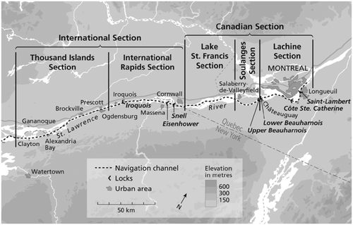
Figure 2. Evolution of the method of regulation for Lake Ontario–St. Lawrence. Courtesy of the International Joint Commission.
To proceed with planning the St. Lawrence Seaway and Power Project the engineers needed to develop a ‘method of regulation’ for the St. Lawrence River and Lake Ontario, which Daniel Macfarlane (Citation2014) covers in detail in Negotiating a river: Canada, the US, and the Creation of the St. Lawrence Seaway. The ‘method of regulation’ (which we will also refer to as the ‘regulation plan’ or just the ‘Plan’) referred to the levels between which the water would be maintained by control works so as to meet prescribed goals. The explicit goal was to maintain the water levels at an average that equated to ‘natural levels’, but it was meant also to improve on nature by removing the extremes of high and low flows in order to create a more predictable river (Macfarlane Citation2014, 181). The baseline for what counted as ‘natural’ was that which had existed prior to the installation of the Gut Dam just downriver from Prescott, Ontario, and Ogdensburg, New York.
All plans and specifications had to be approved by the St. Lawrence Joint Board of Engineers, which was tasked with overseeing and approving construction of the St. Lawrence project, including water levels (after construction was finished the St. Lawrence River Board of Control took over this latter function). The main future users of the St. Lawrence Seaway and Power Project – power production, navigation, shoreline property owners and downstream interests – wanted different minimum and maximum water levels or varying ranges of stages (i.e. differences between high and low levels) and pleasing everyone seemed impossible (IJC Citation1976; Macfarlane Citation2014).
In the early 1950s Lake Ontario had been experiencing record high levels. In 1952 the two countries referred concerns about Lake Ontario water levels to the IJC. Though Lake Ontario levels received a separate IJC docket under this reference, because of construction of the St. Lawrence Seaway and Power Project this issue was necessarily intertwined with the discussion about future levels on the St. Lawrence. Lake Ontario property owners on the south shore formed the Lake Ontario Land Owners and Beach Protection Association, which expressed concerns that previous modifications (e.g. the Gut Dam) to the flow regime of the St. Lawrence had led to high water that sometimes flooded their properties. The IJC formed an International Lake Ontario Board of Engineers in 1953 and tasked it with finding a way of reducing water level fluctuations – historical gauge records indicated that Lake Ontario had a range of fluctuation of more than 6 feet (close to 2 m) – while protecting all interests from injury.
The engineers knew that their provisional regulation plans would need to evolve with construction of the megaproject, not only because of unknown conditions in the field and the inability to predict all future aspects, but also because the process sometimes became politicized and partisan. Canadian and American sections of the International Lake Ontario Board of Engineers initially disagreed about the maximum level of Lake Ontario, as well as the impact of Gut Dam on water levels (Macfarlane Citation2014). The Americans were more motivated by the protests from Lake Ontario beach owners; the Canadian position was largely predicated on protecting Montreal interests (the regulation criteria outlined that the minimum water level of Montreal Harbour would be no lower than would have occurred if the power project had not been built), for any lowering of Lake Ontario levels would tend to raise water levels in the western Quebec section of the St. Lawrence, and potentially reduce power output at the new hydro dam (LAC Citation1955; Bryce Citation1982, 94). At the numerous public hearings that were conducted on the lake levels, many people came to voice their concern about the impact of higher water levels, such as shoreline erosion. The transcripts show that property owners were most worried about their own property value, rather than any wider societal, industrial or ecological benefits.
Eventually, the Commission concluded that Lake Ontario could be regulated within a narrower range of elevations for the benefit of property owners, provided that natural water supplies were no more extreme than those experienced in the past, without causing injury to the other interests. To allow this, additional excavation of the St. Lawrence River channel, at added cost to the power entities, was required. The narrower range of elevations is often referred to as the 4-foot (1.2-m) range, though the lower elevation applies only from April through November. The Commission also recommended 11 criteria for regulating Lake Ontario outflows, and a regulation plan for setting the outflows in a manner that would meet the criteria. The Canadian government also agreed to remove the Gut Dam.
Engineers continued to adapt the regulation method to compensate for errors and assumptions, reflecting the normal iterative process that hydraulic engineers use when dealing with large water systems and scientific uncertainty. In March 1955, the IJC told the Canadian and American governments that it was possible to regulate both the St. Lawrence and Lake Ontario in such a way as to balance the various demands. They replaced ‘method of regulation 5’ with another regulation plan, 12-A-9, but there were still problems with that as well: for example, tests showed that under its parameters the seaway would unduly constrict the channel at Montreal. There was discussion about increasing the upper limit marginally from 248 feet to, for instance, 248.3, but engineers were trying to ascertain the historical conditions on which they based their arguments – even as they admitted they couldn’t know these historical conditions with any certainty – at the same time as they were making their arguments (Macfarlane Citation2014). They kept couching their pronouncements on precise water levels (e.g. 248.3) with the caveat ‘as nearly as may be’. Nonetheless, the IJC believed it had found a range of levels that could best balance the competing interests, users and regions – chiefly hydropower, navigation and shoreline interests.
Once the governments approved the provisions recommended by the Commission, and after additional public hearings, in July 1956 the Commission amended its 1952 Order of Approval. This supplementary order laid out the operation of the water regime moving forward, incorporating Method of Regulation 12-A-9 and the 11 criteria as the guiding principles. The new order of approval stated that Lake Ontario levels should be maintained in a target range between 244 and 248 feet above sea level, again adding ‘as nearly as may be’. Note that the measurements in this paper are given according to the International Great Lakes Datum of 1935, or IGLD35, which was used during the construction of the seaway. Since 1992, lake level measurements are made according to the International Great Lakes Datum of 1985, which has a slightly different ‘zero level’ (additionally, in order to be historically accurate, measurements will only be provided in metric in this paper for the post-1971 period). It would not be long, however, before flaws with Method of Regulation 12-A-9 would become apparent, and it would be replaced by Method of Regulation 1958-A. The St. Lawrence River Joint Board of Engineers nevertheless felt confident enough to authorize the raising of the power pool, which began on 1 July 1958. The filling proceeded very closely with the anticipated schedule, reaching the prescribed forebay level of 236 feet early on the morning of 4 July – it reached 238 feet a few days later, and then 240.5 feet in December 1959 (IJC Citation1958). An elaborate gauging system tracked water levels and flows.
During the first year after the St. Lawrence power pool had been raised, however, there were problems with ‘hanging dams’ of ice forming in the river upstream of the Moses–Saunders Dam that reduced power output, and issues with low water levels downriver from the Moses–Saunders Dam in the early 1960s (IJC Citation1959). It also became apparent that the water level (and thus the power head) was higher on the American side of the Moses–Saunders Dam than on the Canadian side, and as a result the power entities agreed to equally share the output of power, rather than the inflow of water (LAC Citation1961). The Ontario and New York power utilities concluded an operating agreement for the power works, and meetings between the two entities continued well into the 1960s to sort out the division of expenses and take care of remaining aspects of the project. Legal difficulties concerning redress continued, as it seemed that the legal structures in Canada provided no means of compensating those injured by changing water levels. Lake Ontario shore owners in New York unsuccessfully tried to sue Canada because of Gut Dam impacts, and requested that the US Foreign Claims Settlement Commission examine the claims; in 1968 Canada agreed to pay a token $350,000 as settlement for the alleged damage (Goodman Citation1969). After some debate stemming from liability concerns, the St. Lawrence Board of Control was also given the responsibility for controlling the gates at the Iroquois Dam.
Plan 1958-A had remained operational, though engineers were clear that it would likely need to be adjusted; it was superseded by Plan 1958-C at the beginning of 1962, which in turn was replaced in October 1963 by Plan 1958-D, which would remain in place (albeit in modified form) until the twenty-first century when it was replaced by Plan 2014. The Commission and Board of Control made a number of other adjustments to the regulation process as they gained experience. In 1960 the Commission had granted authority to the Board to temporarily deviate from the regulation plan flow under emergency conditions and when ice formed and broke up during winter operations (IJC Citation1960). In 1961, the Board was granted ‘discretionary authority’ to depart temporarily from the plan flow when a deviation of limited magnitude and duration would provide beneficial effects or relief from adverse effects to an interest, without causing appreciable adverse effects to any of the other interests (IJC Citation1961). For example, under certain conditions, increasing the Lake Ontario outflow for a day can make it possible for a vessel to enter Montreal Harbour. Such deviations were only to be made by the Board when they, among other things, would not endanger meeting the criteria and other requirements of the Commission’s Order.
There were significant problems with low water levels in the lake and river in the 1960s, and then high water levels in the 1970s. These were attributed to natural supplies of greater variance than had occurred in the historical period upon which the engineers had based the methods of regulation (Bryce Citation1982, 108; Quinn Citation1999). These fluctuating levels required the Board of Control to enhance its methodology for dealing with deviations. The Board kept account of the deviations and, except in rare circumstances, each deviation required subsequent offsetting deviations from the plan to return the level of Lake Ontario to the Plan 1958-D level. The strategy was based on a risk analysis of high or low levels, and relied on the Board’s judgment (IJC Citation2012, 3). The strategy could specify when flow changes were to be made for specific purposes, such as avoiding critically high or low levels or flows at specific locations. Because the actual Lake Ontario outflow was different from the specified Plan 1958-D outflow on a fairly frequent basis, this approach to regulation was called ‘Plan 1958-D with deviations’ (or Plan 1958-DD) (IJC Citation2012).
Environmental impacts
The St. Lawrence Seaway and Power Project inundated close to 40,000 transnational acres, and required the relocation of the ‘lost villages’ on the Ontario side (Macfarlane Citation2014). In the long term, compared with pre-project conditions, the St. Lawrence and Lake Ontario water levels were more predictable and controllable, and the range of water levels was compressed (i.e. extreme highs were lower, and extreme lows higher). But the environmental repercussions of constructing the St. Lawrence Seaway and Power Project were enormous, and its legacy cannot be fully measured without an appreciation of the ecological impact.
The reconfiguration of the local ecosystem inherent in the St. Lawrence project disrupted the aquaculture, which included circumscribing the success and mobility of many species. The American eel, historically an important part of the St. Lawrence biomass, was blocked from swimming upstream by the 1950s dams, and experienced a 22% mortality rate passing downstream through the turbines (Casselman Citation2005); it is now an endangered species (eel ladders were added to the Moses–Saunders Dam in 1974 and the Beauharnois Dam in 1994). Brief consideration was given to fishways at the beginning of the planning for the power project but soon abandoned; though the Dominion Fisheries Act required all dams to provide a fishway subject to the responsible minister’s interpretation, neither the federal government nor the provincial Department of Lands and Forests insisted on a fishway because of the cost of modifications to the St. Lawrence dams and the ‘general inefficiency’ for the ‘presumed purpose’. Other government officials speculated that the conditions created by the lake might actually be beneficial to wildlife (HEPCO Citation1955).
The St. Lawrence project had other negative impacts on fish: the extensive dredging changed spawning and feeding grounds, and conditions for aquatic life were very poor during the construction period. Numerous species, such as walleye, lake sturgeon and different types of sucker, had used the now-removed Long Sault Rapids as spawning grounds. Modified flows also played a role, as the current was much slower than before the seaway; a University of Ottawa study later showed that the changed water flows upstream from the Moses–Saunders Dam destroyed fish habitat and caused cancerous tumours in bottom-dwelling fish (Ottawa Citizen Citation1998). Though it appears that many of the most prominent fish species found in the river experienced a dramatic and extended decline because of the construction of the St. Lawrence Seaway and Power Project, there has been a rebound in many stocks since the 1980s. Some cold-water species that were intentionally stocked in the Great Lakes have made their way into the St. Lawrence since the 1950s. A 2001 scientific investigation concluded that the types of fish found in the upper St. Lawrence have changed little since the 1930s (Greeley and Greene Citation1931; Great Lakes Fisheries Commission Citation2001, 6). Of course, the seaway also enabled the influx of destructive invasive species. Adding the cost of invasive species to the fact that the seaway never came close to paying for itself as promised (comparing cargo predictions to cargo actually carried, it was a massive failure), and a reasonable observer might well conclude that the seaway aspect (i.e. the navigation aspect) was a mistake.
Changed flow and ice patterns altered scouring and sedimentation processes. During construction, many islands were removed or reshaped, and new islands added. There was a significant increase in the nearshore aquatic habitat in Lake St. Lawrence on account of the greater surface area of the new lake, but much of this was shallow and subject to frequent fluctuations of up to 6.5 feet (2 m) – brought on by both seasonal factors and the operation of the dams – that periodically turned these areas into mud flats unsuitable for fish (Great Lakes Fisheries Commission Citation2001, 5). Granted, these altered nearshore habitats benefited other types of flora and fauna.
It is important to appreciate that the Lake Ontario–St. Lawrence River system is a highly complex, sensitive, multi-jurisdictional and politically charged border region of Canada and the US. While the upper portion is shared between Ontario and New York, the downstream portion starting at the Ontario–Quebec border just east of Cornwall is entirely in Canada. There are a number of important interests that rely on the water level and flow fluctuations in this watershed. Consistent with the interpretation of the BWT at the time, the IJC’s initial methods of procedure gave precedence to domestic and sanitary water use, navigation, riparian and hydroelectric generation rights on the St. Lawrence over environmental and recreational rights. Peaking operations involving major water level fluctuations are hazardous for the riverine environment – they were not considered under the initial IJC order, but the IJC and hydropower interests reversed this (LAC 17 September Citation1962). Regulating Lake Ontario and the river, or any water body for that matter, at too uniform a level, and not allowing for natural and seasonal variability, can be ecologically harmful.
Two different First Nations reserves were directly affected by the creation of the St. Lawrence Seaway and Power Project: Kahnawake Mohawk Territory near Montreal, and the Mohawk Nation of Akwesasne (St. Regis) that straddles the Canada–US border near Cornwall. In 1978, the Akwesasne expressed concern to the IJC about the impact of the St. Lawrence Seaway and Power Project on the International Rapids section. Cornwall Island, part of Akwesasne territory, is directly downstream of the Moses–Saunders Power Dam, and the changed water levels resulting from the power project had a noticeable and deleterious long-term impact on the ecological health of the area. Furthermore, the General Motors and Reynolds industrial plants in New York State had located adjacent to Akwesasne land, with resulting long-range environmental and health implications (Hauptman Citation1986, 144; Martin Citation1999). The adverse effects were grouped into three main categories: those caused by higher water levels, those caused by changes in flow, and those caused by environmental change (IJC Citation1982, Citation1983). A formal submission was made to the IJC in 1981, and the First Nations group made further inquiries about shoreline erosion and adverse effects on the muskrat population in subsequent years.
The IJC studied the issues using the limited evidence available, which included past gauge readings and aerial photography. The IJC’s reports admitted a wide range of negative environmental impacts but deemed them generally not substantial enough, or their causes too uncertain, to require action or compensation. Aerial photography showed that littoral erosion and changes were occurring but were ‘localized in nature’ at erosion-prone sites or had been one-time results of excavation or landfilling from the St. Lawrence project. The IJC declared that peaking and ponding fluctuations (controlled increase and decrease of the water flows) were not a significant factor in the variability of the muskrat population in the Akwesasne area (IJC Citation1983). The IJC concluded that water level fluctuations had decreased since the installation of the St. Lawrence development, and argued that the contention that there had been a general increase in the mean level of the St. Lawrence since the 1950s was not supported by gauge data. At any rate, the wide range of changes identified in the Akwesasne/St. Regis submission could not be fully evaluated, as they were beyond the IJC’s limited time, sources and evidence.
Nevertheless, these reports serve as a summary of the possible ecological damage done by the St. Lawrence project: decreased water quality; loss of land by various types of erosion and island drowning; marshland flooding; weed growth; redistribution of pollutants; scouring and silting; fish and eels killed by powerhouse turbines; impediments to fish movement and spawning; and concentrated pollutants in fish (IJC Citation1982). The claim that there has been shoreline erosion because of wave action from passing vessels in the seaway is supported by anecdotal evidence and IJC studies (Macfarlane Citation2014). Others claim that the St. Lawrence project changed the local weather conditions, possibly because of the increased amount of water surface area (Bowering Citation1999, 96).
Revisiting the method of regulation
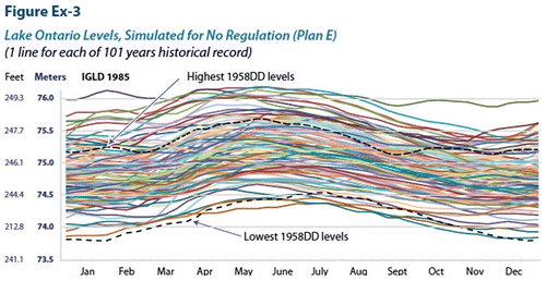
The following figures demonstrate the impacts of regulation on water levels of Lake Ontario and downstream in terms of actual water levels versus pre-project levels (that is, if the project had never been built) (see Figures and ). Over the years, regulation of Lake Ontario outflows provided significant benefits to shoreline property owners by reducing the occurrence of extreme high water levels on Lake Ontario that would have occurred naturally. The period 1972–1973 was an unusually wet period in the Great Lakes Basin, and Lakes Michigan, Huron and Erie set record-high water levels in 1973 which, as the water moved downstream, resulted in unprecedented high water supplies to Lake Ontario. Although the peak Lake Ontario level exceeded the upper limit in the 1956 Order of Approval by 0.36 m (1.2 ft.) and set a record high level for the lake, regulation held the level of Lake Ontario more than 0.30 m (1.0 ft) lower than it would have been without regulation (Lee et al. Citation1994; IJC Citation2014). Regulation provided similar dramatic reductions in Lake Ontario flood levels in the later 1970s and the 1980s, and again in the 1990s. The occurrence of damaging high water levels in the Montreal area has also been greatly reduced by compensating for high flows on the Ottawa River during the spring runoff.
Figure 3. Lake Ontario levels, simulated for plan 1958-DD. Courtesy of the International Joint Commission.
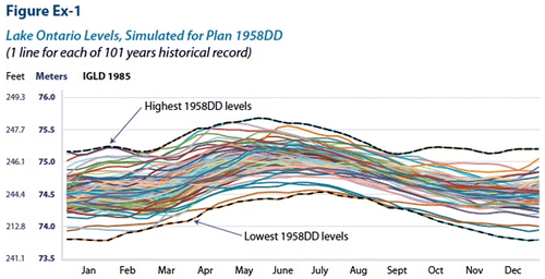
Figure 4. Lake Ontario levels, simulated for no regulation. Courtesy of the International Joint Commission.
Nonetheless, during the 1980s dissatisfaction with Plan 1958-D and the IJC Order of Approval grew among some interests, notably riparians on the south shore of Lake Ontario, recreational boaters and marina owners along the St. Lawrence River in both countries, and environmental interests throughout the system concerned with wetland and habitat loss. As the recreational industry on the St. Lawrence River rebounded, it brought in significant new revenue while at the same time creating conflicts with other users, particularly at sensitive times of the boating season. The expectations of littoral landowners, especially on the shores of Lake Ontario in New York, was that regulation would reduce extreme high water levels and raise extreme low levels such that erosion of the shoreline immediately in front of their properties would be better off than had there been no regulation. When this often did not occur (because nature has a way of overriding humanity’s best intentions), citizens appealed to their political leaders to place pressure on institutions that did not seem to be responding. In the case of Lake Ontario regulation this has occurred quite often and led to many public meetings, hearings, workshops, open houses, press conferences and media briefings over the years – many times seemingly creating more misunderstanding than enlightenment!
In August 1986, during a period of high water levels in the Great Lakes Basin, the governments asked the Commission under a Reference to examine and report on methods of alleviating the adverse consequences of fluctuating water levels in the Great Lakes–St. Lawrence River Basin (IJC Citation1993). Amongst other important recommendations, the Commission’s International Levels Reference Study Board identified the need for additional work related to the regulation of Lake Ontario outflows, and recommended amending the 1956 Order of Approval. In its final report on the study, the Commission committed to review these recommendations as well as the addition of new criteria to the 1956 Order to address the needs of recreational boating and the environment (IJC Citation1993). In response the Commission appointed a member to its International St. Lawrence River Board of Control with expertise in the effects of water levels on recreational boating interests in the upper St. Lawrence River. In 1995, the Commission expanded the membership of its board from eight to 10 members, including some with extensive knowledge of how water level fluctuations affected communities on the south shore of Lake Ontario and in the Montreal area, as well as communities on the upper St. Lawrence River.
The Commission also asked the St. Lawrence River Board of Control to determine whether a better regulation plan could be developed within the bounds of the 1956 Order. The board tested alternative regulation plans and assessed their performance with historical and current water supplies over a 3-year period. In 1997, the Board of Control recommended that beginning in 1998 the Commission implement one of the alternatives (called Plan 35P) and, therefore, renamed it Plan 1998. Plan 1998 faced a general lack of support, along with outright opposition, at six public meetings held by the Board of Control. It fell short of the expectations of Lake Ontario south shore property owners who expected a new plan to significantly reduce the frequency and magnitude of high lake levels, failed to satisfy the expectations of boaters on the upper river who wanted to maintain higher summer river levels into the fall to extend the boating season, and also drew criticism from upstream environmentalists who wanted a return to a more natural range of lake levels. In January 1999, the Commission decided not to implement Plan 1998 because there was insufficient information about the environmental impacts and the proposed plan would not result in enough of an improvement over Plan 1958-D with deviations (IJC March Citation1999).
With the failure to find a revised regulation plan for Plan 1958-D in 1998, and with continued dissatisfaction being expressed by interests in both countries, supported by their elected representatives and the media, the Commission realized something different and significant needed to be done. Although most Commissioners believed they had ‘continuing jurisdiction’ to revise the 1956 Order on their own, they unanimously agreed to ask the governments for their concurrence before any changes were made to the order and regulation plan. This unprecedented step for the Commissioners was in recognition that the applicants for the project were the two governments themselves and ultimately their support (for example to provide members and funding for the St. Lawrence Board of Control and the IJC itself) was realistically needed should any changes be made. Accordingly, the Commission wrote to the governments in April 1999 alerting them that ‘it was becoming increasingly urgent to review the regulation of Lake Ontario levels and flows’ (IJC April Citation1999, 5).
The Commission put together a team to develop a detailed Plan of Study, and transmitted this document to the governments in October 1999. In recommending a comprehensive study the Commission recognized that ‘the cost and effort are significant and that the study may not lead to a resolution of all the issues by producing significant additional benefits for every interest group beyond those already enjoyed’ (IJC October Citation1999). The Commission was proposing a 5-year study and sought US$20 million, shared equally by both countries, over and above its base budget, because it was the first time the Lake Ontario Order and regulation Plan 1958-D had been formally reviewed in 50 years. The governments identified funding the following year, and the IJC appointed the International Lake Ontario–St. Lawrence River Study Board (Study Board) in December 2000 (IJC Citation2006).
In launching the Lake Ontario-St. Lawrence River (LOSLR) Study in December 2000, the Commission formally began the process of reviewing the 1956 Order of Approval. The Commission summarized the main reasons for conducting the study and reviewing its Orders as follows:
| • | Changing needs of the interests. Lake Ontario–St. Lawrence River system interests had increased in extent and variety since 1956 including further development of the shoreline, a longer season for commercial navigation, and the emergence of recreational boating as a significant new economic activity. | ||||
| • | Dissatisfaction on the part of some interests. In the past two decades shoreline property owners and recreational boaters had been expressing increased dissatisfaction over how Lake Ontario outflows were regulated. | ||||
| • | Environmental concerns. The 1956 Order did not take into account the impacts of water regulation on the ecosystem. In particular, restricting the range of water levels had reduced the diversity and resiliency of wetlands. | ||||
| • | More extreme water supplies. Water supplies had been significantly above and below those experienced during the 1860–1954 period of record. | ||||
| • | Climate change. It is important to understand how potential climate change scenarios could affect the regulation of Lake Ontario outflows and compliance with the Order. | ||||
| • | Lack of information about the impacts of regulation. Reliable quantitative information was lacking on the impacts of regulation on shoreline property, recreational boating, and the environment (this list is drawn from IJC Citation2012, 6–7). | ||||
The LOSLR study had quite a number of innovative aspects for an IJC study. Although this was not a Reference per se but rather a review of an Order of Approval, it had many of the hallmarks of an IJC Reference. It included stakeholders on the Study Board itself and all technical working groups established by the Study Board, a Public Interest Advisory Group (PIAG) that played an important role in advising both the Study Board and the IJC on public information and consultation, and development and implementation of a Shared Vision Model (SVM) that all participants in the study were able to use to simulate their preferred regulation plan and to measure their performance against agreed performance indicators. These optional plans were tested with stochastically generated water supplies as well as historical water supplies to ensure they could perform under a wide range of supply conditions. The plans were also tested with four climate change scenarios as this was an important consideration in the study.
Another novel aspect of this study was having the US National Research Council and the Royal Society of Canada conduct an independent peer review of certain aspects that some members of the public were most concerned about. The peer review report pointed to a number of possible improvements and long-term issues such as the use of adaptive management techniques (NRC Citation2006).
The Commission decided that in order not to polarize the public around a specific regulation plan, the optional plans would not be related to a specific interest but use names such as A, B, C, etc., and also, anticipating that the Study Board would not be able to reach consensus on any one specific plan, that ‘best options’ would be preferred rather than a specific plan recommendation. Accordingly the Study Board initially proposed three plans (Plan A, Plan B and Plan D) which, after receiving public comments at a series of meetings in the summer of 2005, became Plan A+, Plan B+ and Plan D+.
The Study Board released its final report in May 2006 and the IJC invited public comment until 15 September 2006. During this period the Commissioners had extensive internal discussions about the review including interpretation of the Boundary Waters Treaty and what measures would be considered suitable and adequate protection of all interests, including those interests not explicitly recognized in the 1956 Order such as environmental and recreational boating. The Commission also consulted with governments because of the integral role they had played to date in the project and the review itself.
The Commission’s internal review led to an exploration of whether additional environmental benefits could be obtained from any of the three candidate plans because Commissioners wanted to address the environmental aspects as much as possible. Two additional plans were developed – a Plan D+ variant called Plan 2007 (for the year in which it was developed), and a Plan B+ variant, which provided more environmental benefits than Plan 2007 but would have adverse consequences to riparians unless mitigation was undertaken. In March 2008 the IJC invited comment on a proposed new order, regulation Plan 2007 and related matters. The Commission wanted to adapt Plan B+ so that the proposed new order included a provision to assess mitigation 2 years after the new order took effect, and if the risks were adequately reduced it would move from Plan 2007 to Plan B+. The Commission also proposed different governance arrangements including a new board structure and a long-term monitoring and adaptive management strategy. The Commission held 10 information sessions on its proposals, followed by 10 formal public hearings.
Much to the Commissioners’ surprise their proposal was largely rejected. Environmental interests wanted to implement Plan B+ as soon as possible and not after 2 years, rather than Plan 2007, while others wanted to keep the current approach in place. Most navigation, shoreline and downstream interests found Plan 2007 to be unacceptable. Some shoreline interests found Plan 2007 would be acceptable if the Commission’s proposal was modified to keep current policies, such as the target range of elevations for Lake Ontario, and flexibility to deviate from plan flows.
During the summer of 2008, Commissioners met in executive session and with representatives of the Governments of Canada and the United States to discuss next steps. After so many years of study and effort, realizing that Plan 2007 would not be acceptable was a difficult decision for the Commissioners to make – some even wanted to close the entire review down and maintain the existing order, regulation plan, and institutional arrangements. Fortunately, an innovative proposal to form a small Working Group (WG) made up representatives from the Governments of Canada, the United States, New York, Ontario and Quebec, along with IJC staff, reinvigorated the effort. It was envisaged that the WG would ‘advise the Commission on a regulation package, in combination with mitigation and adaptive management measures, that would meet a revised set of goals, objectives and criteria, and also be mutually acceptable to all federal, state/provincial governments, and the Commission’ (IJC Citation2008). In September 2008 the IJC informed the federal governments that Plan 2007 was not a practical option and that regulation should be based on a revised set of goals, objectives and criteria, specifically moving toward more natural flows to benefit the environment while respecting other interests (IJC Citation2008). In October 2009, after further detailed consultations, the IJC officially asked each of the governments to nominate two senior officials to serve on the WG.
The first meeting of the WG took place in Ottawa in December 2009 with representatives from each of the federal, state and provincial governments attending. The WG understood the importance of its task and began working collaboratively from the outset, including forming a Technical Subgroup of experts from each delegation. After reviewing the range of regulation plans that had been developed to date, the WG agreed to investigate and further refine a set of release rules based on Plan B+, known as Bv7 (that is, the seventh version of the candidate B plan). The various B plans provided more natural year-to-year variability of Lake Ontario levels, which provides ecosystem benefits, including the restoration of wetland habitat diversity; but this variability also increased the odds of shoreline and riparian damage. The WG also considered a more detailed adaptive management strategy to respond to climate change, modifications to the plan’s management oversight structure and policies on deviations from the plan. All of the design and analysis done leading up to Plan 2007 and to Plan Bv7 used the same evaluation model and, with several minor improvements, the same performance indicators that the Lake Ontario–St. Lawrence River Study Board had developed with stakeholders. Using that system, the WG was able to evaluate about 60 variations on Plan Bv7 before recommending a version to the IJC (IJC Citation2014).
Plan 2014
In 2012, the IJC conducted public information sessions and invited comment on Plan Bv7. After further consultation with stakeholders, deliberation, and refinement to the proposed regulation plan and the other components, the IJC then developed a formal proposal, known as Plan 2014 (IJC Citation2014). Plan 2014 included modifications to the rules of Bv7 to better balance Lake Ontario and river levels during low-supply periods. Also, a set of high and low lake levels were added to trigger special authority to the Board to deviate from Plan Bv7 to better protect water intakes, navigation, boating and riparian interests.
In the summer of 2013, the IJC invited public comment and convened public hearings on the proposed Plan 2014. More than 5500 comments were received in total. This included 206 oral testimonies at the 12 hearings and public teleconferences, over 3500 signatures on four different petitions, more than 700 postcards and form letters, and nearly 1000 written website, email and unique letter responses. This latter group of responses ranged from short endorsements or rejections of Plan 2014 to formal responses from local governments, governmental departments and non-governmental organizations (IJC Citation2014).
The response was polarized. Most south shore property owners in New York State who participated in the hearings, and their local governments, strongly opposed Plan 2014, though a few respondents from that area either supported Plan 2014 or supported the environmental objective but not Plan 2014 itself. Save our Sodus, a non-profit group, presented a petition with more than 400 comments that either opposed Plan 2014 or documented past flooding and erosion problems that had occurred under the current regulation rules. The concerns of these citizens were that the higher high water levels of Plan 2014 would cause more shoreline damage, and that the lower low levels would make boating more difficult. Many shoreline residents and area politicians contended that the IJC’s 1956 order had promised a maximum Lake Ontario level of 248 feet IGLD35 (75.37 m in IGLD85). They claimed that subsequent shoreline developments had been built so as to be safe at this level, and deemed unacceptable any new regulation plan that intentionally raised this level. However, Lake Ontario has been well above this maximum level on numerous occasions because of extreme natural supplies, and the LOSLR had shown that trying to constrain the lake levels had harmed the Lake Ontario ecosystem.
The US Department of Transportation raised concerns that the priority given to environmental objectives in Plan 2014 violated the BWT, reflecting similar statements by several other respondents involved with commercial navigation on the seaway, including the St. Lawrence Seaway Management Corporation, the Canadian Shipowners Association and the Shipping Federation of Canada. The concern from commercial navigation was that Plan 2014 would create significantly lower levels on Lake Ontario in a few years out of a hundred, thus forcing ships to carry reduced loads. Ultimately it was the commercial navigation concerns that had to be, and were, overcome by the IJC before governments gave their concurrence. Other than these groups, there was general, and often strong, support for Plan 2014.
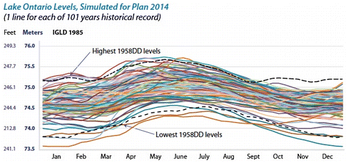
After more than 14 years of intensive analysis and extensive consultation with governments, experts, Lake Ontario and St. Lawrence River interests, and the public, the IJC concluded Plan 2014 should be implemented as soon as possible and so recommended in their June 2014 report to governments. Key features of the plan, outlined in detail in the IJC Report, include a more natural hydrological regime, adjustment for changing supplies, short-term ‘river’ deviations, less frequent need for major deviations from the plan, and adaptive management. Figures (reproduced from the IJC 2014 Report) summarize a comparison of the environmental and economic performance of Plan 2014 and other regulation plans as measured using the performance indicators developed in the LOSLR Study. The Commission wanted to transform the existing International St. Lawrence River Board of Control into the International Lake Ontario–St. Lawrence River Board, and for it to have 10 members, with an equal number from each country, including at least one board member from each of the five federal, provincial and state jurisdictions. In addition, the IJC wanted a balance of expertise on the Board from across the Lake Ontario–St. Lawrence River Basin, including First Nations and Tribes.
Figure 5. Environmental performance, ratio to 1958-DD (historical water supplies). Courtesy of the International Joint Commission.
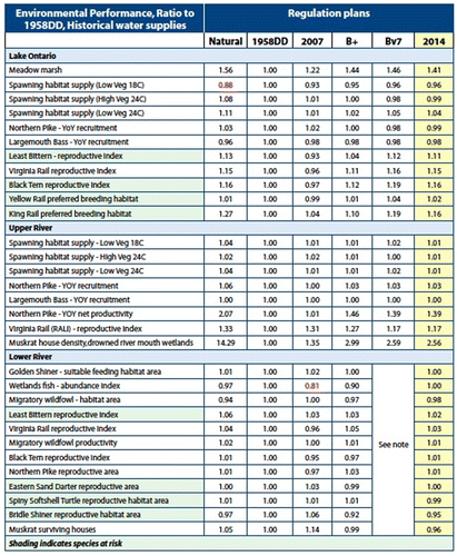
Figure 6. Economic benefits of methods of regulation (in US dollars). Courtesy of the International Joint Commission.
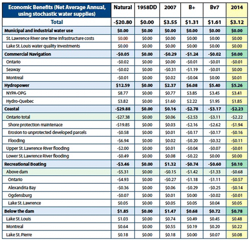
Figure 7. Lake Ontario levels, simulated for plan 2014. Courtesy of the International Joint Commission.
On 6 December 2016, after 16 years of intensive study, consultation and negotiation, the governments of Canada and the US concurred with the Commission’s December 2016 Supplementary Order of Approval and the proposed regulation plan in accordance with certain undertakings as outlined in their letter of concurrence (IJC Citation2016). Part of the delay, on both sides, in achieving government concurrence was the complexity of interests involved and government departments and agencies that needed to be consulted and give their individual concurrences. On 8 December the Commissioners signed the Supplementary Order which gave effect to the new regulation plan, Plan 2014, which went into effect in January 2017.
Unfortunately, the initiation of Plan 2014 coincided with record precipitation throughout the Lake Ontario–St. Lawrence basin in 2017, which resulted in extreme flooding on Lake Ontario, the Ottawa River and the upper St. Lawrence River stretching into Quebec. Reflecting their past opposition, areas on the south shore of Lake Ontario were outspoken in their criticism of the new regulation plan, stoked by the politically motivated and counter-productive criticism of the IJC and Plan 2014 by New York Governor Andrew Cuomo (McDermott and Orr Citation2018). But these criticisms are misplaced, since in instances of extreme natural supply, which was the case in 2017, most any method of regulation can have only a minimal impact on water levels, and flooding would take place regardless since natural water level fluctuations are the major influence.
While legitimate questions can be raised about whether society should even be attempting to control levels on these water bodies, Plan 2014 is clearly an improvement over its predecessor. It is clear that since the 1950s Lake Ontario has experienced a flood event about every two decades, as well as constant shoreline erosion. Yet despite clear historical indicators showing that it is unwise to do so, around areas in New York State such as Rochester and Munroe County, people continue to reside in low-lying topographies (some of which appears to be reclaimed land). Granted, government policies have for decades allowed this (the majority of homes were grandfathered in) with minimal restrictions and requirements, and made property decisions based on imprecise, missing, and outdated maps and information (McDermott and Orr Citation2018). The same could also be said of the low-lying developments downstream in Quebec along Lake St. Louis and near Lake St. Pierre, which were flooded in 2017 and played a role in restricting the outflows of Lake Ontario. By way of comparison, on the Canadian side of Lake Ontario, since Hurricane Hazel in the 1950s there have been prohibitions on building too close to the water’s edge. However, there remain a few locations with vulnerable, grandfathered-in development along the north shore of the lake in Ontario (e.g. Clarington/Bowmanville, Hamilton Beach strip, Brighton, Toronto Islands).
It is inevitable that those in New York State affected by high water levels in 2017 are going to be flood prone in the future, and it is unfair for people to build or continue to live in such areas and then expect to be bailed out with public money or have the method of regulation changed primarily to accommodate them. In most cases, shoreline resiliency measures and other hard infrastructural changes (e.g. storm walls, rip rap, and raising homes) are not going to suffice; difficult decisions will have to be made, and realistically the affected properties will need to be abandoned and littoral spaces turned into buffer zones, particularly with the future of lake levels unclear because of climate change. No future construction should be allowed, and any property significantly affected by high water levels in 2017 should be bought out or expropriated with generous terms given, since it was different levels of government that authorized or grandfathered in homes and buildings in the affected areas.
Conclusion
The process of establishing a method of regulation during the creation of the St. Lawrence Seaway and Power Project was a complex task that involved balancing a number of competing interests, as well as compromises, assumptions and uncertainty. The final regulation method that emerged by the early 1960s did create a system that primarily allowed for power production and navigation, with some protection for riparians. It quickly became apparent that Plan 1958-D had not been designed to adequately deal with a range of water conditions that frequently occurred, and some modifications were made to deal with unintended consequences (Plan 1958-DD). Moreover, the regulation plan and the St. Lawrence megaproject generated a wide range number of detrimental ecological impacts.
Beginning in the 1980s, the IJC began looking to alter or replace Plan 1958-D. Civil society, subnational governments and agencies, nongovernmental organizations, the media and academia all played an important part in keeping pressure on the IJC for change. Despite the lengthy process and the involvement of many Commissioners over a 15-year period, the perseverance and determination of the Commissioners and their staff to succeed and change the regime from one that was known to harm the environment to one that is better is what made the process work. The time and effort needed to make changes to the existing regulation plan and governance framework were extensive and costly, but appropriate given the significant polarization of interests and the benefits that had become expected by interests over the half-century period of regulation experience. The use of innovative techniques by the IJC such as the US National Research Council and the Royal Society of Canada peer review, the PIAG, shared vision modelling, stochastic and climate change modeling, and adaptive management carried over to the next IJC Study on the Upper Lakes and provided a significant benefit to the LOSLR study. The entire process demonstrated a high degree of cooperation between the IJC and senior officials from the federal, provincial and state governments.
In hindsight the IJC could have saved itself considerable time and effort had it thought through more carefully its initial proposal for Plan 2007 before taking it to the public – in some key respects, the IJC was perhaps guilty of treating the method of regulation as primarily a technical issue. Or perhaps it was more of a misread of the governments’ views on the need for, and practicality of the mitigation of, relatively small increases in damages to shoreline properties resulting from more natural levels produced by Plan B+ and Plan Bv7. As a result of the study there is now a greater expectation of public involvement in the operation of the system, which is happening. The adaptive management component is proving to be very successful and may lead to further adjustments in the regulation plan in the years to come. Institutional changes to the IJC Board have been accepted and welcomed by the various interests in the basin. Those considering making changes to a significant water level and flow regulation plan, especially in a transboundary context, would do well to consider the interacting components of law, engineering, history, politics, civil society, the media, and climate change science and adaptive management, forming key alliances as appropriate.
Acknowledgements
Research that contributed to this article was funded by SSHRC and Western Michigan University. The authors would like to acknowledge the help of the editors and peer reviewers, as well as Frank Bevacqua, David Fay, and Sarah Lobrichon.
References
- Bowering, Ian. 1999. Cornwall: From factory town to Seaway City, 1900–1999. vol. 1. Cornwall, ON: Cornwall Standard Freeholder and Stormont, Dundas, and Glengarry Historical Society.
- Bryce, J. B. 1982. A Hydraulic Engineering History of the St. Lawrence project with special reference to regulation of waters levels and flows. Toronto: Ontario Hydro.
- Casselman, John M. February 15-18, 2005. The dramatic decline of the American Eel with special reference to the St. Lawrence River-Lake Ontario system. Great Lakes Fishery Commission. http://www.glfc.org/pubs/lake_committees/ontario/whp/workshopinfo.pdf
- Goodman, Carl F. January, 1969. Canada-United States settlement of Gut Dam claims: Report of the Agent of the United States before the Lake Ontario claims tribunal. International Legal Materials 8 (1): 118–143.
- Great Lakes Fisheries Commission. December 14, 2001. Fish community objectives for the St. Lawrence River (draft). Ann Arbor, MI: Great Lakes Fisheries Commission.
- Greeley, J.R. and C.W. Greene. 1931. Fishes of the area with annotated list. In New York State Conservation Department, A Biological Survey of the St. Lawrence Watershed, Supplement to 20th Annual Report, 1930. Albany: New York State Conservation Department.
- Hauptman, Laurence. 1986. The Iroquois struggle for survival: World war II to red power. Syracuse, NY: Syracuse University Press.
- Hydro-Electric Power Commission of Ontario. December 7, 1955. 91.123, Memorandum re: St. Lawrence Power Project: Conference with Dr. Harness and Dr. Clarke of Department of Lands and Forests on Proposed Fish and Wildlife Studies on Ottawa and St. Lawrence Rivers.
- International Joint Commission. July 3, 1958. 68-2-5, Joint Board of Engineers, 1, Meeting 28 of St. Lawrence River Joint Board of Engineers.
- International Joint Commission. June 10, 1959. 68-8-2:2, St. Lawrence Power Application, SLRJBE – Basic Documents, Brief to the St. Lawrence River Joint Board of Engineers on Ice-Boom Installation for St. Lawrence Power Project.
- International Joint Commission. September 16, 1960. Telegram to the International St. Lawrence River Board of Control.
- International Joint Commission. May 5, 1961. Letter to International St. Lawrence River Board of Control.
- International Joint Commission. 1976. Further regulation of the great lakes: An IJC report to the Governments of Canada and the United States. International Joint Commission (IJC) Digital Archive. https://scholar.uwindsor.ca/ijcarchive/98
- International Joint Commission. March 1982. 68-5-6, St. Lawrence Power Application, General Memorandum 1955, a Report to the International Joint Commission on Concerns of the St. Regis Band Regarding Impacts from the St. Lawrence Seaway and Power Development.
- International Joint Commission. March 1983. 68-3-1:2, St. Lawrence Power Application, Correspondence, C. McGrath, Joint Report by HEPCO and PASNY, “Assessment of Shoreline Erosion and Marshland Recession Downstream of the St. Lawrence Power Project.”
- International Joint Commission. December 1993. Methods of alleviating the adverse consequences of fluctuating water levels in the great lakes–St. Lawrence river basin.
- International Joint Commission. March 17, 1999. Ninety-First Progress Report to the International Joint Commission by the International St. Lawrence River Board of Control.
- International Joint Commission. April 15, 1999. Letter from IJC to Lloyd Axworthy, Minister of Foreign Affairs.
- International Joint Commission. October 29, 1999. Media release.
- International Joint Commission. March 2006. Final Report: Options for Managing Lake Ontario and St. Lawrence River Water Levels and Flows. Prepared by the Lake Ontario-St. Lawrence River Study Board. March 2006.
- International Joint Commission. September 8, 2008. International Joint Commission Letter to the Governments of Canada and the United States.
- International Joint Commission. January 2012. IJC staff paper: History of the Lake Ontario-St. Lawrence River Order of Approval and the Regulation Plan and Related Studies.
- International Joint Commission. June 2014. Lake Ontario-St. Lawrence River Plan 2014: A Report to the Government of Canada and the Unites States by the International Joint Commission. http://www.ijc.org/en_/Plan2014/Report
- International Joint Commission. December 2016. Supplementary Order of Approval 2016 (International Joint Commission in the Matter of the Regulation of Lake Ontario). http://www.ijc.org/en_/Plan2014/Supplementary_Order_of_Approval_2016
- Lee, D. H., F. H. Quinn, D. Sparks, and J. C. Rassam. 1994. Modification of great lakes regulation plans for simulation of maximum lake Ontario outflows. Journal of Great Lakes Research 20 : 569–582.10.1016/S0380-1330(94)71173-4
- Library and Archives Canada. April 26, 1955. RG 25, 6778, file 1268-D-40, pt. 43.2, St. Lawrence Seaway and Power Project – General File, DEA Memorandum: Lake Ontario Levels.
- Library and Archives Canada. September 17, 1962. RG 25, 5026, file 1268-D-40, 54, St. Lawrence Seaway Project – General File, January 8, 1960-February 27, 1962, Memorandum to Deputy Minister re: Peaking Tests at St. Lawrence River Power Project.
- Macfarlane, Daniel. 2014. Negotiating a river: Canada, the US, and the creation of the St. Lawrence Seaway. Vancouver: UBC Press.
- Martin, Kallen M. Spring 1999. Akwesasne environments: Relicensing a seaway after a legacy of destruction. Native Americas Magazine.
- McDermott, Meaghan M., and Steve Orr. January 8, 2018. Rochester Democrat and Chronicle, “Muddled maps complicate future of Lake Ontario shoreline.” https://www.democratandchronicle.com/story/news/2018/01/08/maps-lake-ontario-shoreline/1003068001/
- National Research Council (NRC). 2006. Review of the Lake Ontario-St. Lawrence river studies. Committee to review the Lake Ontario-St. Lawrence river studies. Washington, DC: The National Academies Press.
- Ottawa Citizen. November 2, 1998. Hydro Dam Blamed for Tainting Fish.
- Quinn, F. H. 1999. Anthropogenic changes to great lakes water levels. Great Lakes Update 136 : 1–4.