

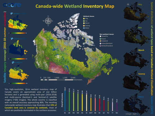
Abstract
Detailed information on the spatial distribution of wetlands is crucial for sustainable management and resource assessment. Furthermore, regularly updated wetland inventories are of particular importance given that wetlands comprise a dynamic, rather than permanent, land condition. Accordingly, satellite-derived wetland maps are greatly beneficial, as they capture a synoptic and multi-temporal view of landscapes. Leveraging state-of-the-art remote sensing data and tools, this study produces a high-resolution 10-m wetland inventory map of Canada, covering an approximate area of one billion hectares, using multi-year, multi-source (Sentinel-1 and Sentinel-2) Earth Observation (EO) data on the Google Earth Engine™ cloud computing platform. The whole country is mapped using a large volume of reference samples using an object-based random forest classification scheme with an overall accuracy approaching 80% and individual accuracies varying from 74% to 84% in different provinces. This nationwide wetland inventory map illustrates that 19% of Canada’s land area is covered by wetlands, most of which are peatlands dominate in the northern ecozones. Importantly, the resulting ever-demanding wetland inventory map of Canada provides unprecedented details on the extent, status, and spatial distribution of wetlands and thus, is useful for many stakeholders, including federal and provincial governments, municipalities, NGOs, and environmental consultants.
Graphical Abstract
RÉSUMÉ
Les informations détaillées sur la répartition spatiale des zones humides sont cruciales pour la gestion durable et l'évaluation des ressources. En outre, un inventaire régulier des zones humides est important étant donné leur nature dynamique. Par conséquent, les cartes des zones humides dérivées des images satellitaires sont très utiles, car elles capturent une vue synoptique et multi-temporelle des paysages. S'appuyant sur des données et des outils de télédétection de pointe, cette étude produit une carte d'inventaire des zones humides avec une résolution de 10 m pour l’ensemble du Canada, couvrant une superficie approximative d'un milliard d'hectares, en utilisant des données pluriannuelles des satellites Sentinel-1 et Sentinel-2 sur la plate-forme informatique en nuage de Google Earth Engine™. L'ensemble du pays est cartographié à l'aide d'un grand volume d'échantillons de référence dans un système de classification forêt aléatoire à base d’objet avec une précision globale d’environ 80% et des précisions individuelles variant de 74% à 84% selon les différentes provinces. La carte finale montre que 19% de la superficie du Canada est couverte de terres humides, dont la plupart sont des tourbières se retrouvant dans les écozones du nord. Cette carte d'inventaire des zones humides du Canada fournit des détails sans précédent sur l'étendue, le statut et la répartition spatiale des zones humides. Elle est donc utile pour de nombreux intervenants, y compris les gouvernements fédéral et provinciaux, les municipalités, les ONGs et les consultants en environnement.
Acknowledgments
The authors would like to thank the Google Earth Engine team for providing cloud-computing resources and European Space Agency (ESA) for valuable open-access Sentinel data. The field data were collected by various organizations, including Ducks Unlimited Canada, Nature Conservancy Canada, Environment and Climate Change Canada (ECCC), and Government of Newfoundland and Labrador Department of Environment and Conservation. The authors thank these organizations for the generous financial support and providing such valuable datasets. Additionally, the authors would like to thank anonymous reviewers for their helpful comments and suggestions.