
Abstract
The landscape of post-secondary education has experienced a dramatic change in student outcomes over the past 20 years. The expectation for students in advanced education was a career in research and toward gaining employment in either academia or in government science. From our survey of university students and early career professionals, it was clear that there is an expectation gap between desired and probable post-secondary education outcomes. Our survey indicated that the majority of trainees, regardless of level of education, undervalue the importance of written and oral communication skills and overvalue specific methodological understanding relative to those employed in the field. While some of these dichotomies can be explained by the relative lack of experience of students, it also points to the nature of the foci of our training. While we are concerned with the production of the next leaders in remote sensing science, most will have careers that are different from their training. There is an opportunity to optimize the post-secondary education experience (student and faculty) with the inclusion of a broader view toward career outcomes.
RÉSUMÉ
Le paysage de l’éducation postsecondaire a connu un changement radical dans les attentes des étudiants au cours des 20 dernières années. Les attentes des étudiants aux études supérieures étaient une carrière en recherche et l’obtention d’un emploi dans le milieu universitaire ou dans les laboratoires de recherche gouvernementaux. D’après notre sondage auprès des étudiants universitaires et des professionnels en début de carrière, il est clair qu’il existe présentement une différence entre les emplois souhaités et ceux probables suite à l’obtention d’un diplôme postsecondaire. Notre enquête a révélé que la majorité des stagiaires, quel que soit leur niveau d’instruction, sous-évaluent l’importance des compétences en communication écrite et orale et surévaluent la compréhension des méthodologies spécifiques employées dans leur domaine. Si certaines de ces dichotomies s’expliquent par le manque relatif d’expérience des étudiants, elles soulignent également la nature des orientations de notre formation. Bien que nous nous préoccupions de l’éducation des prochains chefs de file en sciences de la télédétection, la plupart auront des carrières dans des domaines différents. Il est possible d’optimiser l’expérience des études postsecondaires (étudiants et professeurs) en insérant une vision plus grande des opportunités de carrière.
Introduction
The rapid expansion of remote sensing science and the need for accurate geospatial technology to manage our ever-changing planet has resulted in disruptive forces in remote sensing education. There is little doubt that the current trend in industry and government is toward a future that uses more remotely sensed data. This has resulted in a shift to advanced data science and analytics with non-experts in remote sensing often responsible for producing and interpreting remotely sensed data products. This has forced the remote sensing education community to rethink the skills that are being taught, considering these developing trends. The rapid growth in the Earth Observation (EO) ecosystem, data availability and democratization of remote sensing has been the driver of this disruptive innovation trend. The concept of disruptive innovations (Bower and Christensen Citation1995) is found when the technologies and practices within a discipline are challenged by innovators from outside of the discipline. These innovations are often important because they provide solutions that are outside of traditional approaches. For example, beginning with the release of the Landsat Archive in 2008 and the subsequent development of cloud-based platforms like Google Earth Engine, non-experts have had widespread and easy access to remotely sensed data, as well as to the simple tools needed for analysis (Bodzin et al. Citation2014). Such access by non-experts dramatically increased the use of remotely sensed data beyond typical research and development applications (Bodzin Citation2011). Furthermore, easy access to remotely sensed data also allowed users to gain knowledge about the arrangement of natural and human-built features on the Earth’s surface, their spatial representation, the relationships between them, and new methods of interpretation (Golledge Citation2002).
An example of the proliferation of the use of remotely sensed data is provided by Marcus and Fonstad (Citation2010). They note significant interest in the use of remotely sensed data for better understanding, monitoring, and managing of river systems. While some of the articles reviewed by Marcus and Fonstad (Citation2010) developed new methods for understanding these systems, almost as many papers were written by new users who applied image interpretation methods. Further, a review of the literature by Chasmer et al. (Citation2020) found that almost one third of papers that used remotely sensed data for understanding wetland characteristics, function, and change since 2003 were published in non-remote sensing journals. The highest proportion (more than one half) were published in hydro-ecology journals in 2009 following the public release of the Landsat Archive. This indicates that there is significant interest in the use of spatial and temporal data by non-experts in remote sensing, which was also identified in Bernd et al. (Citation2017), especially as funding initiatives and agencies are advocating for the use of remotely sensed data for a better understanding of Earth and human systems (e.g., Sankey Citation2018).
Earth Observation (EO) has early roots in photography and became operational during World War I (Melesse et al. Citation2007). However, the concept of accessible remotely sensed data began more recently with the EO Summit called by then President of the United States, George W. Bush on July 31, 2003, enabling untapped expansion of data use and application. The creation of a Global Earth Observation System of Systems following the EO Summit has been a success and all the hallmarks of a successful system are present: there is a high degree of international-level cooperation, system diversity, and redundancy (constellations of systems). This has provided a clear vision for our current and future EO ecosystem. As a result, the accessibility of EO data and the acceptance and daily use of such data has been extensive; the public is exposed to EO data daily through Google Earth/Maps, Bing Maps, and numerous other online platforms (Butler Citation2006; Yu and Gong Citation2012; Bey et al. Citation2016). This exposure occurs when watching the daily news on television, mobile mapping applications for smart phones, following the GPS in cars, playing games (such as Geocaching), and so on. There is no doubt that early exposure to publicly available imagery and through elementary and secondary school programs (e.g., Huynh and Sharpe Citation2013) has increased interest in remote sensing tools and data (Gil-Docampo et al. Citation2019). As such, there has also been an unprecedented proliferation of the use of remotely sensed data by non-experts (Yu and Gong Citation2012). Non-experts have also been instrumental in the use of crowd sourcing to identify land cover changes, map communities, identify hazards, and other applications (e.g., See et al. Citation2013). Similar to the use by non-expert user discipline scientists and social scientists, crowd sourcing has increased the rapidity with which the environment is examined and interpreted using nonphysical contact (e.g., Marcus and Fonstad Citation2010; Van Coillie et al. Citation2014). While errors in crowd-sourced data interpretation exist (e.g., Van Coillie et al. Citation2014), Goodchild (Citation2009) noted that there is also growing recognition of benefits of community/public engagement with the academic community through the use of remotely sensed data.
Interest in the identification and organization of objects on the Earth’s surface allows consumers of geographic information to better understand human and physical environments. The discipline of geography, for example, identifies with the idea of spatial thinking (or thinking spatially, geospatial thinking, spatial intelligence, or spatial ability; Huynh and Sharpe Citation2013). Geographers are especially interested in spatial patterns and relationships across space and through time (e.g., Goodchild Citation2009). Huynh and Sharpe (Citation2013) found that understanding of increasingly complex geospatial concepts improves with cognitive development associated with age and geographical training. The ability to examine and interpret spatial information by non-experts may be akin to groups who are not trained in geospatial thinking described in Huynh and Sharpe (Citation2013). Overall, geographic and geospatial thinking is an important aspect of our understanding of our environment and often comes naturally or is of interest throughout various stages of education from youth to maturity (Huynh and Sharpe Citation2013).
Based on these observations of an expanding interest in the benefits that remotely sensed data has to offer, the following question was proposed by professionals and students/post-doctoral fellows (herein “trainees”) and early career professionals at the Canadian Remote Sensing Symposium in July 2020:
What is the direction that education is to take on the preparation of scientists and other professionals in the area of remote sensing in the future?
Our current graduate-level educational system is geared toward producing graduates trained for careers in research. From the early stages of undergraduate education, the goal is to develop and hone skills to enable trainees to succeed at the frontier of science (masters) and for them to lead (at the PhD level) new scientific and technological developments, applications research, and information generation (Zhang et al. Citation2020). This model represents the traditional educational trajectory geared toward the development of academic scientists and researchers. While this represented a successful model when few students pursued post-graduate education, few careers in academic science and research currently exist (e.g., Huynh and Hall Citation2019).
So, while the demand to pursue greater depth of understanding within remote sensing exists, educational objectives have not necessarily kept pace with the outcomes of the trainees. While this is not a new outcome (the majority of PhDs, regardless of discipline, do not work in their area of expertise; Cyranoski et al. Citation2011), it is time to prepare graduates for the careers that they will have, rather than for those that they won’t. Many educational systems have begun to alter educational pathways for trainees to enhance outcomes and manage expectations (Huynh and Hall Citation2019). Bernd et al. (Citation2017) describe the importance of geospatial technologies, including remote sensing in ecology and the need for graduates to obtain a variety of experiences and soft skills to enhance confidence and competition in the job market. For example, Germany is redefining training of PhDs for careers outside of academia by partnering with industry to ensure transferrable skills. A survey of ecologists who use geospatial data (Bernd et al. Citation2017) also suggests that some aspects of training should focus on real-world applications through internship placements. Multi-directional communication with stakeholders have benefits for both trainees and local partners through networking (for the trainee) and expansion of new knowledge (for stakeholders). Other countries have established advancement pathways within public service that require advanced education. For example, India requires advanced degrees for national advancement; however, the quality of PhDs is variable (Cyranoski et al. Citation2011).
This article reports on the results of a survey conducted in 2020 of people in industry, government and academia who specialize in remote sensing in Canada and from a published proceedings article by Ryerson (Citation2014). The primary goal of this article is to inform both trainees/early career professionals and educators of the current and future trends in remote sensing and opportunities for the next generation of remote sensing scientists as observed by the community. The objectives are to:
describe the future of remote sensing over the next 5–10 years as perceived by remote sensing experts in industry and government;
discuss the needs of the remote sensing industry today; and
determine methods to educate trainees in ways that will connect them to industry needs.
Finally, recommendations are provided for educators, trainees and early career professionals, and industry experts in remote sensing to continue to advance innovation in this field now and in the future.
Materials and methods
To conduct this study, a series of survey questions were developed for the (relatively small) Canadian remote sensing community (herein, “the community”). The survey was sent via email to attendees of the Canadian Remote Sensing Symposium and the larger community between June and October 2020, resulting in 45 established professional respondents, herein “professionals.” A second survey was sent to trainees and early career professionals including post-doctoral fellows, of which 50 responded (). Both surveys were provided in English and French to encourage a broad range of responses relevant to the Canadian community. The surveys consisted of 28 complementary questions designed specifically for established professionals vs. student and young professionals’ experiences (examples provided in ). While not all questions are presented, the contrast between respondent groups for the most topical questions provides insight into the current state of student preparedness and the current (and future) state of industry requirements.
Figure 1. Distribution of (a) professional respondent’s current employment, and (b) the employment goals of students and early career professionals upon completion of their degree training.
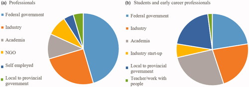
Table 1. Examples of complimentary questions asked of professionals and student and early career professionals.
The questions for both respondent groups consisted of short answer ranking of importance of terms the authors deemed important (e.g., oral and presentation skills) and requests for respondents to include answers that were not provided in lists. Both word “pick lists” and short answers to the survey questions provided an opportunity to quantify and illustrate the importance of the responses from both groups. Numerous methods were used to culminate and compare responses to the complimentary questions. Questions that required ranking of a set of answers/words were counted based on votes of importance and ranks were illustrated using graphs and descriptive statistics. The ranking of answer terms determined based on the proportional frequency for terms deemed “important” were also compared between professional and undergraduate/graduate respondents, in particular. Illustrative methods and classification were used to synthesize and group short answer phrases and words used by the respondents. For example, the frequency of words in short answer responses were used to generate a “word cloud,” where the frequency of word usage corresponds to the size of the text font. Short answers were also divided into base competencies learned in university versus industry skills that were a noted requirement described by professionals. In many cases, direct responses were also provided in quotations as these included ideas and advice beyond descriptive statistics, illustrative diagrams, and charts.
Survey respondents were primarily PhD candidates (n = 22/50) who attended the Canadian Symposium on Remote Sensing in July 2020. From this group, 10 indicated that they were targeting an academic position (45%). Of the master’s candidates surveyed (n = 20/50), 12 (60%) were seeking positions in government, while 5 (25%) had an interest in working in industry. Only a few undergraduate trainees responded to the survey (n = 7), ∼40% desired careers in industry. speaks to the current expectations of trainees and the critical need to provide them with more realistic expectations and employment options in the remote sensing sector.
Results and discussion
Direction of the remote sensing industry: Next 5–10 years and current challenges
The democratization of remotely sensed data has allowed interested experts and non-expert users alike to examine the spatial patterns found on the surface of the Earth. To compare these patterns and to look deeply back in time at the ways in which the environment has changed is enticing. People want to look at their old homes of the past, their favorite places to visit, and new places they have yet to travel to, collecting images and places on digital media (Gazzard Citation2011). In addition to this, remotely sensed data have been continuously collected over the Earth’s surface for decades. Thus, one can truly observe the Earth’s surface, “everywhere, all of the time,” as Baldocchi stated with regard to eddy covariance flux information (Baldocchi Citation2014). A significant shift in the use of remotely sensed data by non-experts has been observed. These non-expert users are operating in the domain of remote sensing via online visualization and simple analyses, while remote sensing experts have pushed further into areas of big EO data use, complex algorithm development, and the intricacies of radar and hyperspectral remote sensing. One professional survey respondent noted:
Promotion and development of further online Google Earth Engine style applications puts application development in the hands of domain experts and limits the need for applications specialists in only remote sensing or other geospatial technologies – democratization of remote sensing. This leads to new problems as non-experts try to deal with some of the challenges [of remote sensing].
Recognizing the shifting use of remotely sensed data today, the curious student or post-doctoral fellow may ask: How will the field of remote sensing change in the future? And Will I be ready for these changes? These are important questions. Further, the ability to predict how the field will change in the next 5–10 years will enable educators to best position the next generation of remote sensing experts to ensure forward movement of technology, methods, and applications development.
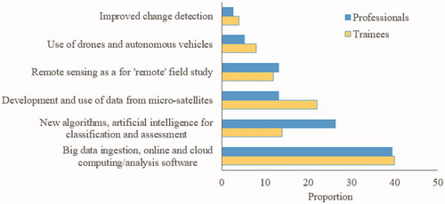
The most significant growth area in remote sensing within the next 5–10 years noted by professionals responding to this survey was in the areas of big data ingestion and online and cloud computing/analysis software (). Artificial intelligence algorithm development was also an area expected to grow in the coming years with increases in classification and assessment of the Earth’s surface and ingestion of multiple data sources for thematic information. One respondent suggested:
Figure 2. Perceived areas of significant development over the next 5–10 years by remote sensing professionals versus trainees and early career professionals.
development of [highly qualified personnel] will be the most important topic in remote sensing … [to] also exploit the many [Space-Based Earth Observation] data archives we already have.
Another suggests that:
fully automated workflows – from acquisition to decision-making; i.e., removing people from the workflow by implementing [artificial intelligence] will become the norm.
Yet, others disagree, suggesting that the need for high-accuracy inputs for science-based decision-making demands continuing human involvement in all but the most routine analyses. Thus, there are opposing opinions from the group of professionals. Trainee and early career professional responses were similar, with a higher proportion suggesting that data from microsatellites would become increasingly important in the future, while the development of artificial intelligence and other new methods for classifying data would begin to wane ().
The movement toward new algorithms for big data ingestion highlights a clear demarcation of the future role of the remote sensing scientist compared to that of non-expert users of remotely sensed data. The discipline of remote sensing may well see a shift, as one respondent noted, from “‘what is’ or ‘what was’ into ‘what will be’ and ‘why it matters.’” One may assume that the advanced use of multiple data streams within a big EO data framework using advanced algorithms using artificial intelligence will require the ability to understand complex environmental issues, have mathematical and geostatistical prowess, and be able to work with computer coding languages and software development to process such data. This will allow remote sensing experts to create information to answer increasingly complex global issues, possibly within a team-based process involving in depth remote sensing and discipline expertise working together. In such an environment accumulation of advanced knowledge across multiple disciplines at the same time will be difficult and require hitherto unexplored approaches to problem solving. Non-experts may continue to examine localized problems, applying more traditional methods of analysis. Alternatively, big data analysts in the computational sciences may advance big EO data use in concert with a lack of knowledge of how Earth and environmental systems work, potentially producing unrealistic or highly uncertain results ().
Table 2. The culmination of major issues faced by remote sensing today and insightful comments by respondents.
However, such a shift in the use of the technology and data could well lead to “disruptive use” rather than disruptive innovation in remote sensing. One respondent stated:
Continued development of [unmanned aerial vehicles/remotely piloted aircraft systems] and opening of new remote sensing markets [would result in] disruptive technology where there is a lack of remote sensing background.
Approximately one third of professional respondents identified that new applications development in areas not typically examined using remotely sensed data would continue to become increasingly important, which could also result in exploratory-type activities by non-experts.
While it is important to understand where remote sensing innovations will occur, one may also ask the question: What are the greatest challenges to remote sensing?
The challenges that will be faced in the next 5–10 years are difficult to determine, especially with new technology and methodological advancements, relatively unforeseen global issues (for example, the current COVID-19 pandemic), and changes in the ways in which society operates. Despite this, there are some challenging areas that may continue to pose problems in the future. When asked about the challenges experienced today, respondents described the biggest issues, culminating in the magnitude/frequency of key words in .
Figure 3. Word cloud of respondent answers to the question: What are the biggest challenges facing remote sensing today?
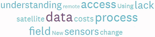
Themes arising from the discussion by professionals from the survey question: “Describe in 1–2 sentences what you think are the biggest challenges facing remote sensing today” are as follows, ranked in order of importance:
Data and technology limitations:
The sheer volume of data (5 respondents)
Data-sharing policies or lack thereof (4 respondents)
Debt faced by countries for supporting deployment of remote sensing technologies (4 respondents)
Skills and knowledge limitations:
The application of remotely sensed data by technical experts who lack fundamental understanding of the Earth System (6 respondents)
The desire to continue to encourage and broaden the use of remote sensing technologies by non-experts and in non-traditional areas of application (5 respondents)
Need for advanced computer and programming skills (2 respondents)
Some thoughts from the community of professionals have been divided into themes in .
Based on the distillation of the major challenges faced in the discipline of remote sensing today, training of the next generation of remote sensing scientists should include a focus on:
computer programming, big data ingestion, and multi-sensor integration of thematic information;
the necessary requirement that the application of remote sensing and knowledge generation must also incorporate an understanding of the environment in which it is applied; and
training of non-experts in remote sensing on how to use and interpret remotely sensed data.
These will be discussed in the following sections, while also integrating aspects of job readiness to position trainees in areas beyond academia and government.
Industry needs from graduates, today
Using predictions of the direction of the field of remote sensing over the next 5–10 years from professional respondents and integrated training of student trainees and early career professionals in these areas, one must also recognize the need for trainees to acquire “job-readiness” skills. These skills and competencies will enhance the dissemination of results, thereby providing important information for non-remote sensing stakeholders.
Enterprising students and post-doctoral fellows may ask:
What are the most optimal set of skills that would allow me to navigate through my career from university and into the workforce directly related to remote sensing and peripheral fields?
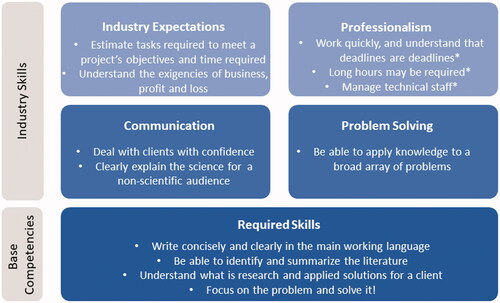
The results of the survey of established remote sensing professionals point toward critical areas of education needing improvement. graphically depicts the skills and abilities needed to increase baseline competencies and largely confirms the skills and abilities summarized in Ryerson (Citation2014; ). Of particular interest is the importance accorded to writing, oral presentation and communications skills, also indicated by survey respondents and noted in several news articles on the topic (e.g., Leef Citation2013). Of the remaining 12 skills and abilities noted by Ryerson (Citation2014; ) all but the last three listed (identified with *) were among those most frequently identified by the established professional respondents. This confirms a recent study in the US by Markow et al. (Citation2019), who examined more than 150 million job advertisements and 56 million resumés between 2007 and 2018. From these, they identified the most important foundational skills of the digital economy. Communication and the ability to write were identified by 56% of survey respondents and by Markow et al. (Citation2019) in three of four “Building Blocks Skills”: Human Skills, Domain Knowledge, and Business Enabler Skills. This clearly illustrated the importance of the ability to communicate within the job market. In combination with other foundational skills including creativity, critical thinking, analytical skills, communicating data, project management, and managing/analyzing data, some of which were also found in survey responses on the use of remote sensing data and understanding in ecology in Bernd et al. (Citation2017) and Płoński (Citation2019). Enhancing these skills will ensure a smoother transition into the job market for remote sensing university graduates.
Figure 4. Weighted importance of baseline to distinguishing competencies and skills determined from survey respondents and adapted from Markow et al. (Citation2019).
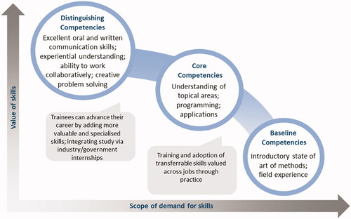
Figure 5. Baseline competencies as required skills for remote sensing scientists and division of industry-required skills adapted from Ryerson (Citation2014).
In addition to survey responses, Bloomberg (Citation2015) did a study of desirable skills for business school graduates based on responses from 1320 recruiters from 600 companies. They identified skills that are highly desirable but not often found in recent graduates, including strategic thinking, creative problem solving, leadership skills, and communication skills (). Other skills identified as desirable, but more common, included analytical thinking, adaptability, and industry-related experience. In addition to these, charisma and collaboration potential were also important skills for preparation of student success beyond the prestige of the university (for computer science majors) identified in Way et al. (Citation2019). While Bloomberg (Citation2015) focused on business schools and the needs of industry for their graduates, the summary of required skills provided in the article also supports desired skills identified for the field of remote sensing.
Table 3. Matching between respondent identification of desirable skills of remote sensing trainees and early career professionals vs. generalized business skills considered common and more desired from Bloomberg (Citation2015).
The differences in respondent’s impression of important remote sensing knowledge skills between undergraduate and graduate students, young professionals, and professional respondents is illustrated in . In the survey, the results show that as trainees gain more experience, graduate students place more importance on writing and presentation skills and have grown confidence in understanding applications. As a result, graduate students place little importance on technologies and less emphasis on independent research as an important component of remote sensing.
Figure 6. Magnitude and proportion of respondents’ views on the importance of remote sensing topics and skills by (a) undergraduate respondents compared with professionals; and (b) graduate respondents compared with professionals. The size of the bubbles indicates greater differences between trainees and professionals.
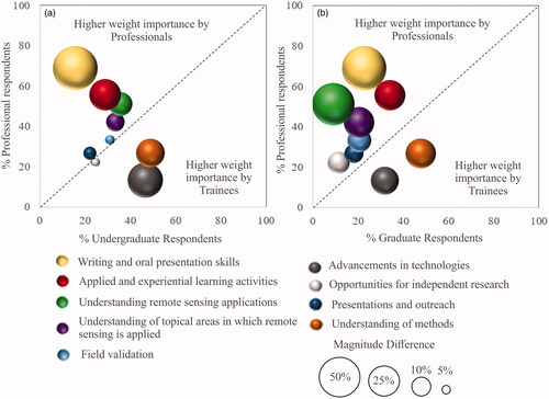
Large differences were also observed between trainees and professionals. The major difference occurred in the value placed on writing and oral presentation skills, also noted above: more than three times the number of professionals indicated these skills as important while trainees tended to emphasize the understanding of methods (). This is not a surprising result as it clearly shows how learning a science normally progresses. Two other areas also showed significant differences. Professionals noted that applied experience, such as hands-on experiential learning and laboratory exercises, were more important than understanding of remote sensing applications. Of interest in the latter () is that undergraduate perceptions were closer to those of the professionals than were the opinions of the graduate students. This may be an indication that graduate students have developed confidence through their experience in research. When trainees were asked the question “Do you believe that your university education has prepared you for a successful career in remote sensing?” 54% of respondents noted high or very high confidence that their university education has prepared them for successful careers. When compared to ecology students, for example, who took remote sensing courses, they desired more training in remote sensing and geospatial technologies to benefit their career potential (Bernd et al. Citation2017). This demonstrates a desire for interdisciplinarity among disciplines that do not typically incorporate the intensity of remote sensing training in their discipline. This also does not necessarily mean that trainees in remote sensing disciplines have the broad understanding required by the work force. Płoński (Citation2019) suggests that it is critical that technological enhancement in education continue, especially in Earth-based physical sciences like geography. Alternatively, graduate students may be influenced by supervising professors where a focus on methods and advanced technologies is encouraged. There also appears to be less appreciation of the topical areas in which remote sensing methods are applied, for example, forestry or agriculture, by trainees who focus on remote sensing. Professionals place almost double the weighting on understanding of environmental systems compared with graduate students.
Other interesting contrasting results occurred when analyzing responses to the weight placed on understanding applications and advances in technologies. The professionals surveyed placed far greater weight than either student group on understanding applications and much less importance on advances in technology. In Hopkinson et al. (Citation2007) respondents to a survey provided on the need for airborne lidar training noted that operational priorities were of greatest interest to industry, while government priorities included end-user applications. These disparities again speak to the differences between students learning about remote sensing and professionals who are working with remote sensing technology.
While these illustrate differences between university trainee understanding and professional needs, professionals have provided a number of tips for recent graduates and early career professionals. These include (in order of weighting of importance):
62% of respondents placed high importance on understanding what the organization/industry does when applying for a job, how it uses remotely sensed data, and problems that the organization is working on or interested in solving.
38% of respondents suggest reading as much as possible about the organization before your job interview and, equally important, think about how you (the early career professional) will fit into their organization.
18% suggested that early career applicants should look into some of the strengths and weaknesses of the organization, and how they may be able to navigate these.
In addition to these suggestions, many respondents (>20%) encourage trainees to become involved in professional organizations and working groups. Respondents also encouraged educators to take a more active role in enabling connections between academia and industry. It may be the case that the most enterprising, confident students and early career professionals will likely engage in a broader range of extracurricular activities, become better known, and may have better opportunities. Such attributes were also described in Way et al. (Citation2019) in other technological disciplines.
Education: Connecting trainee learning to industry needs
The goals and objectives of university education have been debated since the advent of the modern university. The survey results have highlighted a fundamental disconnect between trainees (all levels) and professionals in a number of key dimensions. Through the survey and direct experience, industry focuses on those attributes that societies create universities to serve – communication skills, broader understanding/knowledge acquisition-transfer, and flexibility of thought (). The highly technical nature of remote sensing leads to the perception by many trainees (at all levels) that their future will be one governed by and focused on technological developments and advanced algorithms. These were two factors that industry respondents did not consider a priority ().
The challenge in university instruction is to convey the reality of the future opportunity without presenting a dim view. This presents a new question for educators:
How must students be educated and trained to meet the needs of the remote sensing community, while also creating opportunities to improve job-readiness across a range of fields, not necessarily focused on academic and government remote sensing research-based initiatives?
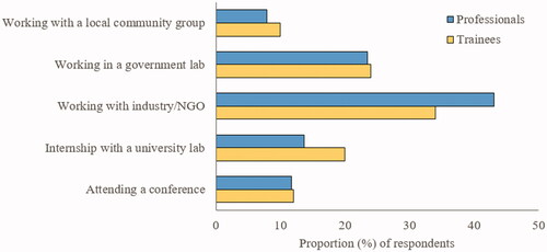
Programs that promote cooperative education at the undergraduate and graduate levels are particularly successful at bridging the gap in skill training that post-secondary education often does not focus on. While acquiring skills like project management, team building, and networking are essential once employed, it is clear that trainees do not usually have a sense of what industry does or how they may fit into organizations. These are areas where cooperative education can bridge the gap and provide trainees with additional tools to assist them in their early careers, especially if networking experiences enable trainees to interact with potential employers. illustrates the importance placed on experiential learning and networking activities by professionals and trainees. While most trainee respondents view experience with industry as highly beneficial to their overall careers, many respondents noted a preference to careers in academia or government institutions () (although this will be skewed due to the focus of the trainee survey on conference attendees).
Figure 7. Weighting of importance of beyond university experiences from professionals versus trainees.
Other missing pieces include feedback from industry into university programs. Past experience with national-level funding programs (Natural Sciences and Engineering Research Council of Canada, Collaborative Research and Training Experience program, Geomatics for Informed Decisions have provided some perspective on the need for industry and government research feedback into post-secondary education programs; Coburn Citation2019). There is a clear needs-gap between the job requirements of industry and students’ training (Bernd et al. Citation2017). This gap is even more apparent in light of disruptive innovation in the remote sensing sector. Trainees have specific knowledge on the use and processing of remotely sensed data but lack experience in implementation of remote sensing applications. For example, when trainees were asked the question: “At the [separated into undergraduate and graduate] level, in which areas do you think your university education in remote sensing could be improved?” 35% of undergraduate students and 9% of graduate students listed the need for broader understanding of remote sensing applications. A complementary question for professionals provides greater insight of the application of remotely sensed data across (spatial and temporal) scales: “From your experience for recent university graduates and the [separated into undergraduate and graduate] level, which of the following skills need to be improved upon?” ∼51% of respondents suggested improvement of broad remote sensing applications at the undergraduate level. This was less of a concern (23%) at the graduate level. These results indicate a desire for learning outcomes that concentrate on a broader range of applications, especially at the undergraduate level. Feedback from industry enhances education, but without mechanisms to obtain information on future industry requirements, post-secondary training continues along a different path. Therefore, it appears that the research requirements for post-secondary trainee success are not always at odds with industry needs, but they are on different paths (Bernd et al. Citation2017; Huynh and Hall Citation2019).
The primary objective of a university education is to produce an educated society by training in areas of critical thinking and problem-solving (Teichler Citation2015). This objective is often confused or distorted as the perception of universities as training facilities is contrary to the mandate of university education in Canada. Trainees are not normally aware of the objectives of their education and as tuition has increased dramatically, they expect outcomes (jobs) that will allow them to be productive members of societies. However, as suggested in Teichler (Citation2015), this depends on shifting competencies (known or otherwise) of industry.
This study has demonstrated this disconnect in remote sensing education at the undergraduate and graduate levels across Canada. The education system is designed with clearly mandated programs that allow trainees a degree of focus in their chosen major with the promise of further depth and sophistication at more advanced levels (graduate degrees). Broadly, the objective of graduate programs is to prepare trainees for careers as scientists through the development of complex understanding of innovative methods and demonstrated productivity (e.g., Way et al. Citation2019). At the highest level, doctoral programs prepare trainees to become professors. This study demonstrated that 45% of PhD students surveyed were targeting an academic job () when it is known that fewer than 10% of PhD students ever end up employed in the academic sector (Cyranoski et al. Citation2011).
In general, the focus of academia tends to be on research and post-graduate trainees. Furthermore, faculty members’ success is defined largely by research results and publications, not their effectiveness as teachers preparing trainees for careers. Another way of looking at the current situation is that the focus is on the production of research and researchers (Way et al. Citation2019). The current study on educating remote sensing scientists suggests that most trainees will not pursue occupations in research and thus their education may not be properly focused if long-term success of the graduates is to be one of the end goals. This issue was also raised in Bernd et al. (Citation2017) and Huynh and Hall (Citation2019), who suggest other complementary aspects of training including networking, soft skills, problem solving, and working in interdisciplinary teams. Hands-on projects were identified in Bernd et al. (Citation2017) as the most effective method for learning, while linking research to stakeholders were among the most important skills required for preparing for careers outside of academia. The question that must be asked is: does your curriculum reflect your research or your trainee’s future? Kugel (Citation1993) identifies five stages of teaching based on informal observation, where early stages of teaching maturity may focus on “self” and subject matter. These shift toward more complex styles of teaching and learning in later stages of teaching maturity. In more recent years, shifts in teaching have also moved toward training of competencies to ensure career success (Płoński Citation2019).
Added to this set of contradictory factors is the changing classroom. With COVID-19, changes to the classroom that had already begun, notably online or virtual education, have accelerated. Indeed, some universities have seen offering online training as a new income stream, one that is not constrained by the need to have a physical classroom or limits on class sizes that are typically seen in classroom education in remote sensing. Will such courses be the way that future trainees learn how to apply remote sensing?
This creates additional questions for the education of the future generations of remote sensing scientists, which will be determined in time: Where will students of the future be employed? Will industry characterized as being in Science, Technology, Engineering, and Mathematics play a significant role as a receptor of trainees? Or will more trainees be employed by environmental or natural-resource focused firms? In either case does the focus of the current approach to education adequately prepare trainees for these diverse sectors?
Recommendations
Recommendations for university educators
The role of university education is critical for the continued development of remote sensing. The success of the Canadian remote sensing community depends on the ability to continue to produce top-quality researchers who develop the technologies and approaches that lead to broader applications and more jobs. The reality that the field must face is that there is a growing divide between academic intentions and the reality of the job market for trainees (Huynh and Hall Citation2019). Markow et al. (Citation2019) and others (e.g., Bernd et al. Citation2017; Huynh and Hall Citation2019; Zhang et al. Citation2020) suggest that higher education needs to ensure that graduates possess a broader range of skills (human, business, and digital skills) than are traditionally being taught. The responses to this survey underpin this point, some of which have been described for other disciplines that use remotely sensed or technical data and methods but are not expert in this field (e.g., Bernd et al. Citation2017; Way et al. Citation2019) or have been described previously within more technical fields of remote sensing (e.g., Hopkinson et al. Citation2007). Key skills include:
The fundamentals of remote sensing combined with an understanding of Earth systems.
Technical skills such as programming, technologies, and applications development, with some field or experiential learning.
Engage faculty on skillsets of importance to the remote sensing community beyond academic research questions of interest to university faculty.
Include teaching and learning of important skills of interest to the remote sensing and broader Earth analytics/digital economy sectors.
Focus on writing and presenting, project management, critical thinking, and problem solving, applying creativity to solve problems, data management and analysis, and business procedures.
Provide experiential learning activities and provide documentation (credentials) that demonstrate competency.
Encourage professors to do sabbaticals with industry to provide greater connectivity between industry, professor, and trainees within the professor’s research group.
Work closely with industry to better understand and coordinate the current objectives of industry for within classroom learning, internships, and job-readiness skills development.
Provide better communication of the importance of skills to trainees and early career professionals.
Encourage recognition of alternate advanced degree programs that focus on cooperative education or laddered credentials to achieve advanced degrees.
Recommendations to trainees and early career professionals
The recommendations for university educators should be passed along to trainees and early career professionals, and are synthesized from the recommendations of the survey as well as more generalized results of Markow et al. (Citation2019):
While writing and communicating well takes (a lot of) practice, trainees should value this, and other job-readiness skills offered by their university educators, as these will help them advance their careers beyond post-secondary education.
Trainees should seek to advance key skills identified by remote sensing professionals in topical areas including: algorithm and methodological application, programming, environmental/Earth system understanding, industry software standards (including key skills using online and freely available software). These skills can be gained through co-curricular and hands-on learning activities initiated by the trainee.
Develop strategies in university and via workshops, micro-credentialing, boot camps, and national certification of remote sensing professionals to continuously update and acquire new skills.
Learn by doing: Supplement your education by becoming involved in volunteer work, internships, or applied study with industry. Trainees should organize this themselves as doing so demonstrates initiative and increases their presence within the community.
Continuously read and explore evolving skill requirements by reviewing job advertisements, labor market reports, and directionality of industry remote sensing developers and data users. Learn how to identify and apply these skills to fields that may be on the periphery of remote sensing.
Connect with and learn from savvy peers and mentors in the discipline. Discussion is one of the best ways to learn and recall information.
Recommendations for employers and professional bodies/societies
There are several recommendations to the scientific, technical and industry community in the field that emerge from the findings of this study and the associated review of the literature. These include:
Engage with university/college professors to provide recommendations for the design and updating of remote sensing course curricula. In return, university/college professors should reach out to key industry players to engage on the latest interests of industry.
Provide certification and engage with academia and industry to establish a set of standards for remote sensing in Canada.
Recognize and encourage baseline and core competencies () while working with university/college professors and administrators; and develop distinguishing competencies in the most promising trainees.
Continue to promote industry-based learning skills that expands opportunities for professionals in industry that link to important skills training of universities (e.g., new methods and technologies of interest).
Work closely with universities to determine and coordinate the expectations for remote sensing now and in the future through the use of internships, job-readiness skills (e.g., business, interpersonal and communication skills).
Enable partnerships between professors and industry through sabbatical programs.
Conclusions
The range and variety of experience brought to the classroom in Canadian universities is among the best in the world. In addition, one finds a wide range and high level of expertise in both government and industry that can be used by universities, professors, and trainees through industry–academic–government relationships. By shifting focus to incorporate both academic and industrial needs in remote sensing, educators will be better positioned to provide trainees with knowledge that not only benefits the academic remote sensing community, but industry and government stakeholders as well.
We recommend that the Canadian Remote Sensing Society (CSRS) explore ways in which this experience can be shared between and with faculty members, perhaps through an online database or record of activities, skills, experiences, and success (e.g., similar to that disseminated in Teichler Citation2015). In addition, the CSRS is encouraged to pursue professional certification programs that provide recognized credentialing for professionals. This will provide quantification and better understanding of the direction and motivations of the field of remote sensing, the use of geospatial data to answer important questions, to inform policy, and perhaps most importantly, to ensure that the future generation of remote sensing experts have the skills needed to continue to grow this dynamic and critically important area of Earth system monitoring.
Acknowledgments
First, we would like to thank all anonymous participants of the surveys for the insights they have provided to this article. We would also like to acknowledge the Canadian Remote Sensing Society for hosting the Canadian Remote Sensing Symposium in an online format in June 2020 (during the COVID-19 pandemic). Dr. Chris Hopkinson is acknowledged for his untiring efforts to chair the online conference. We also thank Dr. Brigitte LeBlon and Dr. Chris Hopkinson, who provided advice on the formulation of the survey questions, and Ms. Lucie Lebrun-Ginn, who assisted with translating the surveys into French.
Disclosure statement
The authors declare that no financial interest or benefit has arisen from the research presented. The authors declare no conflict of interest.
References
- Baldocchi, D. 2014. “Measuring fluxes of trace gases and energy between ecosystems and the atmosphere – the state and future of the eddy covariance method.” Global Change Biology, Vol. 20 (No. 12): pp. 3600–3609. doi:https://doi.org/10.1111/gcb.12649.
- Bernd, A., Braun, D., Ortmann, A., Ulloa‐Torrealba, Y.Z., Wohlfart, C., and Bell, A. 2017. “More than counting pixels–perspectives on the importance of remote sensing training in ecology and conservation.” Remote Sensing in Ecology and Conservation, Vol. 3 (No. 1): pp. 38–47. doi:https://doi.org/10.1002/rse2.27.
- Bey, A., Sánchez-Paus Díaz, A., Maniatis, D., Marchi, G., Mollicone, D., Ricci, S., Bastin, J.-F., et al. 2016. “Collect earth: Land use and land cover assessment through augmented visual interpretation.” Remote Sensing, Vol. 8 (No. 10): pp. 807. doi:https://doi.org/10.3390/rs8100807.
- Bloomberg. 2015. “Job skills companies want but can’t get.” Bloomberg. https://www.bloomberg.com/graphics/2015-job-skills-report/
- Bodzin, A. 2011. “The implementation of a geospatial information technology (GTI)-supported land use change curriculum with urban middle school learners to promote spatial thinking.” Journal of Research in Science Teaching, Vol. 48 (No. 3): pp. 281–300. doi:https://doi.org/10.1002/tea.20409.
- Bodzin, A.M., Fu, Q., Kulo, V., and Peffer, T. 2014. “Examining the effect of enactment of a geospatial curriculum on students’ geospatial thinking and reasoning.” Journal of Science Education and Technology, Vol. 23 (No. 4): pp. 562–574. doi:https://doi.org/10.1007/s10956-014-9488-6.
- Bower, J.L., and Christensen, C. 1995. “Disruptive technologies: Catching the wave.” Harvard Business Review, December. https://hbr.org/2015/12/what-is-disruptive-innovation
- Butler, D. 2006. “Mashups mix data into global service.” Nature, Vol. 439 (No. 7072): pp. 6–7. doi:https://doi.org/10.1038/439006a.
- Chasmer, L., Cobbaert, D., Mahoney, C., Millard, K., Peters, D., Devito, K., Brisco, B., et al. 2020. “Remote sensing of boreal wetlands 1: Data use for policy and management.” Remote Sensing, Vol. 12 (No. 8): pp. 1320. doi:https://doi.org/10.3390/rs12081320.
- Coburn, C.A. 2019. “The AMETHYST Program: The NSERC CREATE experience.” In GIScience Teaching and Learning Perspectives, edited by S. Balram and J. Boxall, 53–62. Amsterdam, The Netherlands: Springer.
- Cyranoski, D., Gilbert, N., Ledford, H., Nayar, A., and Yahia, M. 2011. “The PhD factory: The world is producing more PhDs than ever before. Is it time to stop?” Nature, Vol. 472 (No. 7343): pp. 276–279. doi:https://doi.org/10.1038/472276a.
- Gazzard, A. 2011. “Location, location, location: Collecting space and place in mobile media.” Convergence, Vol. 17 (No. 4): pp. 405–417. doi:https://doi.org/10.1177/1354856511414344.
- Gil-Docampo, M., Ortiz-Sanz, J., Rego-Sanmartin, T., and Arza-Garcia, M. 2019. “A world wide web-based practice that disseminates photogrammetry: Inspiring secondary students to pursue geomatics careers.” IEEE Geoscience and Remote Sensing Magazine, Vol. 7 (No. 1): pp. 86–97. doi:https://doi.org/10.1109/MGRS.2018.2876565.
- Golledge, R.G. 2002. “The nature of geographic knowledge.” Annals of the Association of American Geographers, Vol. 92 (No. 1): pp. 1–14. doi:https://doi.org/10.1111/1467-8306.00276.
- Goodchild, M. 2009. “NeoGeography and the nature of geographic expertise.” Journal of Location Based Services, Vol. 3 (No. 2): pp. 82–96. doi:https://doi.org/10.1080/17489720902950374.
- Hopkinson, C., Popescu, S., Flood, M., and Maher, R. 2007. “A survey on the need for airborne lidar training.” Photogrammetric Engineering & Remote Sensing, Vol. 73 (No. 5): pp. 537–546. doi:https://doi.org/10.14358/PERS.73.5.537.
- Huynh, N.T., and Hall, G.B. 2019. “Navigating employment prospects for new graduates in the geospatial sciences.” In GIScience Teaching and Learning Perspectives, 145–169. Amsterdam, The Netherlands: Springer.
- Huynh, N.T., and Sharpe, B. 2013. “An assessment instrument to measure geospatial thinking expertise.” Journal of Geography, Vol. 112 (No. 1): pp. 3–17. doi:https://doi.org/10.1080/00221341.2012.682227.
- Kugel, P. 1993. “How professors develop as teachers.” Studies in Higher Education, Vol. 18 (No. 3): pp. 315–328. doi:https://doi.org/10.1080/03075079312331382241.
- Leef, G. 2013. “For $100K, you would at least think that college grads could write.” Forbes, December 11. Accessed on Feb 18, 2021. https://www.forbes.com/sites/georgeleef/2013/12/11/for-100k-you-would-at-least-think-that-college-grads-could-write/?sh=28cc54e1c994
- Marcus, W.A., and Fonstad, M.A. 2010. “Remote sensing of rivers: The emergence of a subdiscipline in the river sciences.” Earth Surface Processes and Landforms, Vol. 35 (No. 15): pp. 1867–1872. doi:https://doi.org/10.1002/esp.2094.
- Markow, W., Hughes, D., and Bundy, A. 2019. “The new foundational skills of the digital economy.” Burning Glass Technologies. Accessed February 18, 2021. https://www.burning-glass.com/wp-content/uploads/New_Foundational_Skills.pdf
- Melesse, A.M., Weng, Q., Thenkabail, P.S., and Senay, G.B. 2007. “Remote sensing sensors and applications in environmental resources mapping and modelling.” Sensors, Vol. 7 (No. 12): pp. 3209–3241. doi:https://doi.org/10.3390/s7123209.
- Płoński, A. 2019. “Geospatial technology competency model–Geography academic competencies.” Geography and Tourism, Vol. 7 (No. 1): pp. 63–76.
- Ryerson, R.A. 2014. “So, you want to be employed? Some advice for graduate students in remote sensing.” Paper presented at the IEEE International Geoscience and Remote Sensing Symposium, Quebec City, Canada, July 13–18.
- Sankey, S. 2018. Blueprint for Wildland Fire Science in Canada (2019-2029). Edmonton, Canada: National Resources Canada, Canadian Forestry Service Northern Forestry Centre.
- See, L., Comber, A., Salk, C., Fritz, S., Van Der Velde, M., Perger, C., Schill, C., McCallum, I., Kraxner, F., and Obersteiner, M. 2013. “Comparing the quality of crowdsourced data contributed by expert and non-experts.” PLoS One, Vol. 8 (No. 7): pp. e69958. doi:https://doi.org/10.1371/journal.pone.0069958.
- Teichler, U. 2015. “Changing perspectives: The professional relevance of higher education on the way towards the highly‐educated society.” European Journal of Education, Vol. 50 (No. 4): pp. 461–477. doi:https://doi.org/10.1111/ejed.12146.
- Van Coillie, F.M., Gardin, S., Anseel, F., Duyck, W., Verbeke, L.P., and De Wulf, R.R. 2014. “Variability of operator performance in remote-sensing image interpretation: The importance of human and external factors.” International Journal of Remote Sensing, Vol. 35 (No. 2): pp. 754–778. doi:https://doi.org/10.1080/01431161.2013.873152.
- Way, S.F., Morgan, A.C., Larremore, D.B., and Clauset, A. 2019. “Productivity, prominence, and the effects of academic environment.” Proceedings of the National Academy of Sciences, Vol. 116 (No. 22): pp. 10729–10733. doi:https://doi.org/10.1073/pnas.1817431116.
- Yu, L., and Gong, P. 2012. “Google Earth as a virtual globe tool for Earth science applications at the global scale: Progress and perspectives.” International Journal of Remote Sensing, Vol. 33 (No. 12): pp. 3966–3986. doi:https://doi.org/10.1080/01431161.2011.636081.
- Zhang, Y., Chen, J., and Cui, W. 2020. “Evaluation of the graduate attributes achievement on specialty of remote sensing science and technology.” Paper presented at the 2020 IEEE International Conference on Teaching, Assessment, and Learning for Engineering (TALE), Taka,atsu, Japan, December 8–11.