Abstract
The methods used in an earlier study focusing on the province of Ontario, Canada, were adapted for this current study to expand the study area over eastern Canada where the infrastructure is at risk of being impacted by freezing rain. To estimate possible impacts of climate change on future freezing rain events, a three-step process was used in the study: (1) statistical downscaling, (2) synoptic weather typing, and (3) future projections. A regression-based downscaling approach, constructed using different regression methods for different meteorological variables, was used to downscale the outputs of eight general circulation models to each of 42 hourly observing stations over eastern Canada. Using synoptic weather typing (principal components analysis, a clustering procedure, discriminant function analysis), the freezing rain-related weather types under historical climate (1958–2007) and future downscaled climate conditions (2016–2035, 2046–2065, 2081–2100) were identified for all selected stations. The potential changes in the frequency of future daily freezing rain events can be projected quantitatively by comparing future and historical frequencies of freezing rain-related weather types.
The modelled results show that eastern Canada could experience more freezing rain events late this century during the coldest months (i.e., December to February) than the averaged historical conditions. Conversely, during the warmest months of the study season (i.e., November and April in the southern regions, October in the northern regions), eastern Canada could experience less freezing rain events late this century. The increase in the number of daily freezing rain events in the future for the coldest months is projected to be progressively greater from south to north or from southwest to northeast across eastern Canada. The relative decrease in magnitude of future daily freezing rain events in the warmest months is projected to be much less than the relative increase in magnitude in the coldest months.
R ésumé [Traduit par la rédaction] Nous avons adapté pour la présente étude les méthodes utilisées dans une étude précédente concernant l'Ontario, au Canada, afin d'étendre la zone étudiée à l'est du Canada où l'infrastructure risque d'être touchée par la pluie verglaçante. Pour estimer les répercussions possibles du changement climatique sur les événements de pluie verglaçante futurs, nous avons adopté un processus en trois étapes dans cette étude : (1) la réduction statistique, (2) le typage des conditions synoptiques et (3) les projections dans le futur. Nous avons employé une méthode de réduction basée sur la régression, construite à l'aide de différentes techniques de régression pour différentes variables météorologiques, pour réduire les sorties de huit modèles de circulation générale à chacune de 42 stations d'observations horaires dans l'est du Canada. Au moyen du typage des conditions synoptiques (analyse des composantes principales, une procédure d'agrégation, analyse discriminante), nous avons identifié les types météorologiques liés à la pluie verglaçante dans le climat historique (1958–2007) et les conditions climatiques réduites futures (2016–2035, 2046–2065, 2081–2100) pour toutes les stations sélectionnées. Les changements potentiels dans la fréquence future des jours avec pluie verglaçante peuvent être projetés quantitativement en comparant les fréquences futures et historiques des types météorologiques liés à la pluie verglaçante.
Les résultats modélisés montrent que l'est du Canada pourrait subir plus d'événements de pluie verglaçante dans la dernière partie du présent siècle durant les mois les plus froids (c.-à-d. de décembre à février) que ce qu'indiquent les conditions historiques moyennées. Réciproquement, durant les mois les plus chauds de la saison à l'étude (c.-à-d. novembre et avril dans les régions méridionales; octobre dans les régions septentrionales), l'est du Canada pourrait subir moins d'événements de pluie verglaçante dans la dernière partie du siècle. En se déplaçant du sud vers le nord ou du sud-ouest vers le nord-est dans l'est du Canada, il est prévu que l'accroissement du nombre d'événements de pluie verglaçante durant les mois les plus froids ira en grandissant. La diminution relative du nombre d'événements futurs de pluie verglaçante durant les mois les plus chauds devrait être beaucoup moins importante que son accroissement relatif durant les mois les plus froids.
1 Introduction
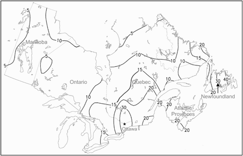
Freezing rain is one of the major meteorological hazards experienced by mid-latitude nations of the globe. It causes significant damage to overhead wires, communication towers, trees and agriculture due to ice accumulation; even small amounts of ice can cause dangerous driving and walking conditions (Regan, Citation1998; Dore, Citation2003; Changnon, Citation2004; Cheng et al., Citation2007; Houston and Changnon, Citation2007). Among all Canadian hydrometeorological disasters, freezing rain is associated with the most costly damage sustained per event (Dore, Citation2003). Freezing rain affects many parts of Canada, especially eastern Canada where eastern Newfoundland and the Ottawa River valley have the highest frequency of freezing rain events (). In eastern Newfoundland, freezing rain is most frequently associated with southeast surface winds blowing from the Atlantic to form a warm layer above a shallow sub-freezing layer over a cold surface (Stuart and Isaac, Citation1999). Freezing rain occurs frequently in the Ottawa area when supercooled rain falls into a shallow sub-freezing layer trapped within the valley basin (McKay and Thompson, Citation1969; Cheng et al., Citation2004).
Fig. 1 Approximate contour locations for seasonal total freezing rain hours over eastern Canada (October–May, 1953–2007).
To diminish the devastating effects associated with these events, there continues to be a substantial amount of research conducted on determining the relationships that exist between weather conditions and freezing rain events over a short period of time. As summarized in a recent paper (Cheng et al., Citation2007), the previous studies on freezing rain comprise three main areas: Equation(1) development of statistical models in order to improve the accuracy of short-term numerical weather forecasts, (2) analysis of the climatology of freezing precipitation, and (3) case studies of individual freezing rain events. In addition, some studies developed ice accretion models to simulate icing amounts or ice loads on power lines (Yip, Citation1995; Makkonen, Citation1998; Ryerson and Ramsay, Citation2007; DeGaetano et al., Citation2008). However, to date, it appears that very few studies have investigated the possible impacts of climate change on future freezing rain events. The severity and frequency of future freezing rain events in Canada could be expected to increase as freezing rain-related weather systems move northward or northeastward over North America under a changing climate late this century (Cheng et al., Citation2007). The scientific information on projections of future freezing rain events is essential for decision-makers to improve the adaptive capacity of infrastructure at risk of being impacted by freezing rain in Canada. In light of this concern, Environment Canada recently completed a climatological research project to investigate climate change and freezing rain over south-central Canada with a focus on the province of Ontario (Cheng et al., Citation2007). The project had three-steps: Equation(1)
regression-based downscaling to derive future hourly station-scale climate data, (2) synoptic weather typing to identify freezing rain-related weather types under historical and future climate conditions, and (3) projections of changes in frequency of future daily freezing rain events from the historical condition. A general conclusion that was made from the study is that synoptic weather typing could be useful in assessing changes in the occurrence frequency of future freezing rain events. As temperatures warm under future climate scenarios, the model results indicate that the province of Ontario could experience more freezing rain events during the winter (i.e., December to February).
However, in Canada, the infrastructure in all of eastern Canada, not just in Ontario, has been, and continues to be, at risk from freezing rain. As shown in , freezing rain has affected all of eastern Canada for the past 55 years (1953–2007). It is necessary for us to adapt the methods used in the earlier study (Cheng et al., Citation2007) to expand the study area over eastern Canada using more downscaled updated General Circulation Model (GCM) outputs including the Fourth Assessment Report of the Intergovernmental Panel on Climate Change (IPCC-AR4) scenarios. This study focuses on projections of changes in frequency and severity of future daily freezing rain events in terms of daily freezing rain duration rather than icing amounts. The severity of daily freezing rain events in this paper refers to the number of hours during a day when freezing rain occurs (e.g., ≥4 or ≥6 h). We hope that this study provides further scientific information on projections of future daily freezing rain events over eastern Canada, which could be useful for various industries (e.g., transportation, energy, commerce) and communities to revise engineering infrastructure design standards, develop adaptation strategies and policies, and reduce the associated risks.
2 Data sources and treatment
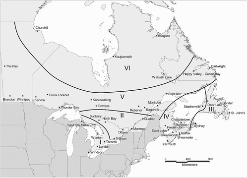
To estimate possible impacts of climate change on future freezing rain events (excluding freezing drizzle and ice pellets), various data, including surface meteorological observations, upper-air reanalysis data, and GCM outputs, are needed. The information on data descriptions, variables and sources is briefly described in . Surface hourly meteorological observations for 42 stations in eastern Canada, where freezing rain events have been experienced during the period 1958–2007, were used in the study (). Except for freezing rain, missing data were interpolated using a temporal linear method when the observed data were missing for three consecutive hours or less; days with data missing for four or more consecutive hours were excluded from the analysis. Across the study area, 1.4% of the total days required missing data interpolation; after interpolation, the dataset was 99.4% complete.
Table 1. Data used in the study.
Fig. 2 Location map of study points with hourly meteorological observations and the regional classification of freezing rain stations.
In addition to the meteorological observations, the six-hourly reanalysis data at 06:00, 12:00, 18:00 and 00:00 utc for the period 1958–2007, retrieved from the US National Centers for Environmental Prediction (NCEP) website, were included in the analysis. Relative humidity data were converted into dew point temperatures. To combine the gridded reanalysis data with the surface weather data, the reanalysis data from the surrounding 4-grid domain fields were interpolated to the selected weather stations using the inverse-distance method (Shen et al., Citation2001). Cheng et al. Citation(2010) have tested two other domain sizes (i.e., 16- and 36-grid) and concluded that the 4-grid interpolation is best, based on its correlation with radiosonde data.
Daily climate change scenarios from eight GCM outputs, four Canadian (with a spatial resolution of approximately 300 km), two US (about 200 km), and two German GCMs (about 200 km), were used in the analysis. Canadian GCM outputs were retrieved from the website of Environment Canada (Environment Canada, Citation2007a, Citation2007b) and the four other GCM outputs were retrieved from the website of the Program for Climate Model Diagnosis and Intercomparison (PCMDI, 2007). These GCM outputs were simulated based on three IPCC climate change scenarios (i.e., A2, B2 and B1). These scenarios considered different assumptions of future greenhouse gas (GHG) emissions derived from distinctly different directions for future population growth, economic development and technological change. From Environment Canada's website (Environment Canada, Citation2007c), it is seen that scenario A2 is similar to the IPCC “business-as-usual” scenario. Compared to scenario A2, scenario B2 produces much lower GHG emissions and aerosol loadings in the future and projects less future warming, especially in the second half of this century. Scenario B1 projects the lowest emissions and least future warming of the selected three scenarios. These scenarios were used in the study to generate a range of projections of possible climate change impacts on future daily freezing rain events.
3 Analysis techniques
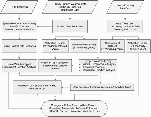
To project possible impacts of climate change on future freezing rain events, the methods developed by Cheng et al. Citation(2007) were adapted for this study. The methods comprise three-steps: 1) statistical downscaling, 2) synoptic weather typing, and 3) future projections, for which the principal steps and methodologies are summarized in . Each of the steps will be described briefly in the following section; for detailed information refer to the study by Cheng et al. Citation(2007).
Fig. 3 Flow chart of principal methodologies and steps used in the study.
a Statistical Downscaling Methods
To project changes in frequency and severity of future daily freezing rain events, future hourly station-scale climate data are needed for the use of synoptic weather typing. As a result, the regression-based downscaling method developed by Cheng et al. Citation(2008) was used in this study to derive future hourly climate information. The downscaling methods comprise two-steps: 1) spatial downscaling for daily climate data from the GCM domain field to the selected weather stations shown in ; and 2) temporal downscaling from daily to hourly climate data. The downscaling transfer functions were constructed using different regression methods to derive future hourly station-scale climate data. The meteorological variables, including surface and upper-air temperature, dew point, west–east and south–north winds, air pressure and total cloud cover, were downscaled. These weather parameters are essential to the analysis of climate change impacts on freezing rain for the current study. Performance of the downscaling methods was evaluated using the following steps:
| 1. | analyzing the coefficients of determination (R 2) for the downscaling transfer functions, | ||||
| 2. | validating downscaling transfer functions using a cross-validation scheme, and | ||||
| 3. | comparing extreme characteristics of the weather variables, seasonal and diurnal variation, and data distribution between downscaled GCM control runs and observations over the period 1961–2000. | ||||
The evaluation results showed that regression-based downscaling functions performed very well, which implies that the methods used in the study are suitable for downscaling future climate data. For example, the values of R 2 for the hourly downscaling transfer functions are greater than 0.95 for surface air temperature, dew point and sea-level air pressure, derived from both model development and validation datasets. Details of the hourly downscaling methodologies and their validation results are not presented in this paper due to limitations of space (refer to Cheng et al. Citation(2008) for details).
b Automated Synoptic Weather Typing
The synoptic weather typing approach has become a useful tool to evaluate the impacts of climate change on a variety of environmental problems. One of the reasons is its ability to categorize a complex set of meteorological variables as a coherent index (Yarnal, Citation1993; Cheng and Kalkstein, Citation1997), which can facilitate climate change impact analysis. An automated synoptic weather typing procedure, based primarily on similarity and differentiation of air mass characteristics within and between weather types, was used to assign every day in the dataset to a distinctive weather type from November to April (October to May for northern stations) from 1958/59 to 2006/07. The synoptic weather typing, combining the correlation matrix-based principal components analysis (PCA), average linkage clustering procedure and discriminant function analysis, attempts to find a suitable classification solution as it minimizes within-category variances and maximizes between-category variances. The synoptic weather typing is a two-stage process: 1) daily synoptic weather types were categorized using PCA and an average linkage clustering procedure (a hierarchical agglomerative cluster method) and 2) all days in the dataset were regrouped by discriminant function analysis (a non-hierarchical method) using centroids of the hierarchical weather types as seeds. As described in the earlier study (Cheng et al., Citation2007), the cluster structure resulting from non-hierarchical reclassification was improved with smaller within-cluster variances and larger between-cluster variances.
Similar to the earlier study (Cheng et al., Citation2007), the entire suite of 240 weather variables, including 144 surface and 96 upper-air variables, was used in the synoptic weather typing. Using the above procedures, 23 to 28 major synoptic weather types, with a frequency greater than 1% of the total days, were identified across the study area, which captured more than 90% of the total days. Weather types with a frequency less than 1% of the total days were still included in the analysis. Of these weather types, four were identified as the primary freezing rain-related weather types for all selected stations over eastern Canada; up to three additional freezing rain-related weather types were also recognized for some stations. These freezing rain-related weather types can capture 75 to 100% of daily freezing rain in three categories: ≥1h, ≥ 4 h and ≥6 h, over the entire period. The synoptic weather typing was evaluated using the validation dataset. The meteorological data used in the study were divided into two parts, one for model development and one for validation. About one-fourth (12 seasons) of the total number of seasons (49 seasons) for the period 1958/59 to 2006/07 were randomly selected to validate the identified weather types classified using the remaining three-fourths of the dataset (37 seasons). The validation results indicated that synoptic weather typing is an appropriate tool to verify weather types since the validation dataset yielded similar meteorological characteristics within synoptic types to those constructed from the developmental dataset. Results on development and validation of synoptic weather typing are not presented in this paper due to limitations of space (refer to Cheng et al. Citation(2007) for details).
c Projection of Occurrence Frequency of Future Daily Freezing Rain Events
To project occurrence frequency of future daily freezing rain events, future synoptic weather types are needed. Similar to the earlier study (Cheng et al., Citation2007), discriminant function analysis was used to determine future daily synoptic weather types using downscaled future hourly climate data. To determine future weather types, principal component scores for each of the future days were calculated by multiplying the post-eigenvector matrix by the standardized future climate data matrix. To compare component scores from both historical and future datasets effectively as well as to remove the GCM model bias, downscaled future climate data were standardized using the mean and standard deviation of downscaled GCM control runs (1961–2000). Using the centroids of the predetermined weather types as seeds, discriminant function analysis can assign each of the future days into one of the predetermined historical weather types based on component scores. This method is able to produce future freezing rain-related weather types with weather characteristics similar to those in the historical period. In addition, this method is proposed to be an appropriate approach to project future freezing rain-related weather types since the weather characteristics—combination of surface and upper-air weather variables within a certain range of atmospheric thermal and moisture conditions that are suitable to form freezing rain—won't change under a changing climate in the future. In other words, if such weather characteristics change in the future, the precipitation type has to be changed and the weather type will not be associated with freezing rain events.
Following determination of future weather types, the occurrence frequency of future daily freezing rain events can be projected based on changes in the frequency of future synoptic weather types from the historical condition. The within-weather-type frequency of future daily freezing rain events is assumed to be directly proportional to the change in frequency of future freezing rain-related weather types. This assumption is based on an expectation that the year-to-year fluctuations of freezing rain occurrences are closely associated with the occurrence frequencies of the freezing rain-related weather types. Cheng et al. Citation(2007) have investigated this relationship and concluded that monthly frequency of daily freezing rain events generally increases with the frequency of freezing rain-related weather types.
d Classification of Freezing Rain Stations
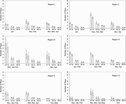
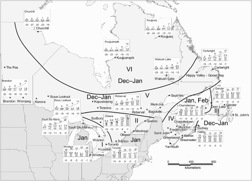
To present projected results on changes in future daily freezing rain events for the study area more effectively it is necessary to classify the 42 stations over eastern Canada, shown in , into some regions with unique freezing rain-related climatological characteristics. The historical occurrence of monthly freezing rain days and changes in the percentage frequency of future daily freezing rain events were used as indicators to classify the stations. The classification method comprises the correlation matrix-based PCA and the average linkage clustering procedure. The 24 variables produced from the monthly mean number of days observed with freezing rain ≥1 h and the percentage changes in the number of future monthly freezing rain days for three time periods (2016–35, 2046–65, 2081–2100), for each of six months (November–April), were used in the classification of freezing rain stations. The PCA was applied to the 24 variables for the 42 stations, producing a solution where 93% of the total variance within the dataset was explained by six components. The remainder of the components with eigenvalues less than one was discarded. The average linkage clustering procedure was performed on the spatial six-component scores and resulted in six freezing rain regions for the study area (). The resultant classification regions for the province of Ontario derived from this study are consistent with the regions subjectively classified by the earlier study (Cheng et al., Citation2007). shows the regional mean numbers of the six-month total days with observed freezing rain ≥1 h, ≥4 h and ≥6 h. More detailed information on regional mean numbers of historical freezing rain days and projection of their future changes, on a monthly basis, will be presented in Section 4.
Table 2. Within-region seasonal mean number of days observed with freezing rain ≥1 h, ≥4 h and ≥6 h in a six-month period (November–April).
e Grouping by Months
To present the results on changes in frequency of future freezing rain events more effectively, in addition to regional classification of freezing rain stations, the months were divided into three groupings, based on change magnitudes in frequencies of future monthly freezing rain events. The three groupings of the months represent different change patterns of future freezing rain days: Equation(1) large increase, (2) moderate or small increase, and (3) decrease or no change. The grouping combinations of the months vary from region to region, as shown in . Generally, grouping Equation(1)
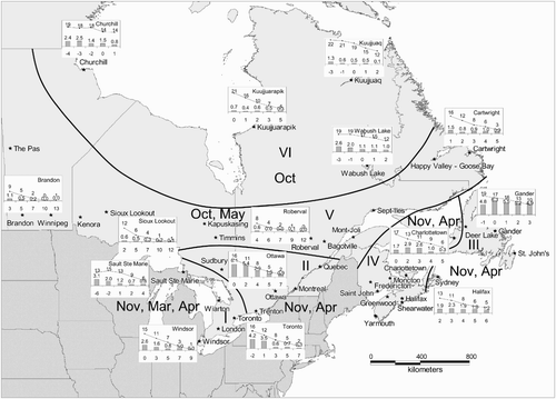
includes the coldest months over eastern Canada, specifically, January in the southern regions (Regions I and II) to December to February in the northern regions (Regions III, V, and VI). Conversely, grouping (3) includes the warmest months of the study season, for example, November, March and April in Region I to October and May in Region V and October in Region VI.
Table 3. Three groupings of the months with different change patterns of future freezing rain events in six regions over eastern Canada.
4 Results and discussion
a Changes in Occurrence Frequency of Future Daily Freezing Rain Events
As described above, synoptic weather typing is able to capture most of the historical daily freezing rain events using the validation data of observed meteorological variables. It is still necessary to evaluate the synoptic weather typing performance to ascertain whether the method is suitable for projecting changes in frequency and severity of future daily freezing rain events. This can be achieved through comparison of the occurrence frequency of daily freezing rain events derived from downscaled GCM control runs to observations over the time period (November–April, 1961–2000). The mean occurrence frequencies of freezing rain events that occurred for ≥1 h, ≥4 h and ≥6 h during a day, derived from both observations and the downscaled GCM control runs, are presented in , as shown by regions and groupings of months. The results indicate that the corresponding frequencies derived from downscaled GCM control runs are in good agreement with observations but with slightly smaller quantities of projections. These small differences, resulting from GCM biases, should be considered to further adjust projections of future daily freezing rain events by the following expression for each of the monthly groupings and each of the stations:
Fig. 4 Mean occurrence frequencies of freezing rain events for ≥1 h, ≥4 h and ≥6 h per day, derived from observations (left bar of each pair) and four downscaled GCM control runs (right bar of each pair) over the time period 1961–2000, summarized by region and monthly grouping. The 95% confidence interval is indicated.
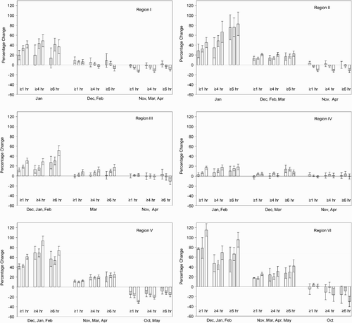
Following the adjustment, percentage changes in occurrence frequencies of future daily freezing rain events from the averaged historical conditions (1958–2007) were analyzed for each of the six regions and each of the three groupings of months (). The 95% confidence interval representing the internal statistical certainty among the downscaled GCM outputs is also illustrated in for each of the regions and each of the monthly groupings. It is immediately apparent from that eastern Canada could experience more freezing rain events late this century during the coldest months, especially during monthly grouping Equation(1). Conversely, during the warmest months of the study season (i.e., monthly grouping (3)), eastern Canada could experience slightly less freezing rain events late this century. In addition, the magnitude of these relative changes was projected to be greatest towards the end of the current century (2081–2100) and smallest in the earlier period (2016–2035). The major findings are summarized as follows:
| 1. | The magnitude of relative increases in occurrence frequency of future daily freezing rain events for monthly grouping Equation(1) | ||||
| 2. | The magnitude of relative increases in occurrence frequency of future daily freezing rain events for monthly grouping (2) is much less than that in monthly grouping Equation(1) | ||||
| 3. | The magnitude of relative decreases in occurrence frequency of future daily freezing rain events in monthly grouping (3) is projected to be much less than the magnitude of relative increases in monthly grouping Equation(1) | ||||
| 4. | Generally, for the entire season, eastern Canada, with the exception of Region I, would experience more freezing rain events in comparison with the averaged conditions of the period 1958–2007. In Region I, the seasonal occurrence frequency of future daily freezing rain events is projected to be similar to the averaged conditions of the period 1958–2007, with less than ±5% changes. In Region IV, the seasonal percentage increase is projected to be less than 10% across three freezing rain events and three future time periods. The corresponding percentage increases for Regions II, III, V and VI could be about 10–20%, 10–30%, 15–40% and 20–40%, respectively. | ||||
| 5. | The relative increases in future daily freezing rain events for monthly grouping Equation(1) | ||||
| 6. | The variability of relative increases in future daily freezing rain events between different GCMs is generally much smaller than that between different scenarios. The average of relative increases in future daily freezing rain events was calculated, pooling all freezing rain events (≥1 h, ≥4 h and ≥6 h per day) and six regions. Differences in the averaged relative increases for monthly grouping Equation(1) | ||||
Fig. 5 The averaged percentage change in the number of daily freezing rain events from the eight GCMs compared with the 1958–2007 average conditions, summarized by region and monthly grouping (left bar: 2016–35, centre bar: 2046–65, right bar: 2081–2100). The 95% confidence interval is indicated.
b Historical Evidence to Support Future Projections
The possible reason for the model-projected increases in frequency of future daily freezing rain events during the coldest months (monthly grouping Equation(1)) over eastern Canada could be that, as temperatures warm under a future changing climate, the freezing rain belt located in the boundary between snowfall and rainfall areas could move northward and northeastward in the study area. On the other hand, the reason for the model-projected decreases in frequency of future daily freezing rain events during the warmest months (monthly grouping (3)) could be that, as temperatures warm, some precipitation falling as freezing rain under current climate conditions could fall as liquid rain under future warmer conditions. To verify this theory, we have evaluated freezing rain trend analyses using the data record for the period 1953–2007: the number of monthly freezing rain hours in warmer years versus colder years. In warmer years, if freezing rain events occurred more frequently in the study area, the freezing rain belt moved northward and northeastward into eastern Canada from the United States during the past 55 years. Such relationships between temperature and freezing rain events are likely to be similar under a future warmer climate since the weather conditions that currently favour freezing rain will be the same in the future. Otherwise, if weather conditions change, precipitation will not fall as freezing rain but rather as liquid precipitation (rain) or frozen precipitation (snow).
Monthly mean temperature and the number of monthly total freezing rain hours were examined for each month of monthly groupings (1) and (3). In addition, the analysis included the number of monthly total days with hourly temperatures observed, for ≥12 h, from −8° to +1°C within monthly grouping Equation(1) and from −6° to +1°C within monthly grouping (3). These temperature ranges are selected based on historical analysis, during which over 98% of total daily freezing rain events occurred over the past 55 years. The months were then divided into temperature quintiles based on the sorted monthly mean temperatures during the period 1953–2007. Within each of the temperature quintiles, monthly mean total freezing rain hours, monthly mean total days within the temperature ranges and monthly mean temperatures were calculated. The first quintile represents the lowest monthly mean temperature, the second quintile the second lowest, and so on, with the fifth quintile representing the highest monthly mean temperature.
The results of the quintile analysis for monthly grouping Equation(1) are illustrated in . To display the results effectively, a few stations (1–4) were selected for each of the regions to represent general patterns of results of monthly temperature quintile analysis. Generally, during the months in monthly grouping Equation(1)
over all regions, the number of monthly mean freezing rain hours increases from the lowest to the highest temperature quintiles. The corresponding increase, for the number of monthly mean total days with hourly temperatures observed, for ≥12 h, from −8° to +1°C, is also revealed. For example, in Ottawa, as the within-quintile monthly mean temperature increases from −15° to −11° to −7°C, the monthly total hours of freezing rain occurrence increases from 5.8 to 8.2 to 14.1. The corresponding increases in the number of monthly total days with hourly temperatures observed, for ≥12 h per day, from −8° to +1°C, are from 5 to 9 to 17. However, the magnitudes of these increases from the lowest to the highest temperature quintiles vary from region to region, with a higher value in the northern regions (II, III, V and VI) than in the southern regions (I and IV). It is noteworthy that the regional variations in increases of magnitudes are highly consistent with the magnitudes of the projected relative increases in future daily freezing rain events as shown in . For example, from , it can been seen that the relative increases in future daily freezing rain events (≥6 h per day) for monthly grouping Equation(1)
in Regions V and VI are projected to be 50–80% and 60–100%, respectively, from the averaged condition during the period 1958–2007. However, the corresponding increases in Regions I and IV are projected to be 10–40% and 10–20%.
Fig. 6 Monthly mean total hours (bar) of freezing rain events and monthly mean total days (line) with hourly temperature observed, for ≥12 h per day, from -8° to +1°C, within each of the monthly mean temperature quintiles in monthly grouping Equation(1) during the period 1953–2007 (the horizontal axis is within-quintile monthly mean temperature).
The results of the quintile analysis for monthly grouping (3) are shown in . During monthly grouping (3) (the warmest months of the study season), changes in monthly mean freezing rain hours and monthly mean total days (with the temperature range from −6° to +1°C, ≥12 h) with the temperature quintiles are opposite to those during monthly grouping Equation(1). During monthly grouping (3), these monthly mean quantities generally decrease from the lowest to the highest temperature quintiles over eastern Canada. For example, in Ottawa, as the within-quintile monthly mean temperature increases from 0° to 4° to 7°C, the monthly total hours of freezing rain occurrence decreases from 6.1 to 2.9 to 0.9. The corresponding decreases in monthly mean total days with the temperature range (−6° to +1°C, ≥12 h) are from 16 to 8 to 2. In the late autumn and early spring, over eastern Canada, freezing rain will likely occur when temperatures are low enough; otherwise, precipitation will fall as rain.
Fig. 7 Monthly mean total hours (bar) of freezing rain events and monthly mean total days (line) with hourly temperature observed, for ≥12 h per day, from -6° to +1°C, within each of the monthly mean temperature quintiles in monthly grouping (3) during the period 1953–2007 (the horizontal axis is within-quintile monthly mean temperature).
Following the trend analysis on the number of monthly freezing rain hours in warmer years versus colder years, one question could be asked: can this trend analysis be used for projections of changes in future daily freezing rain events without synoptic weather typing? As pointed out by Cheng et al. Citation(2007), this trend analysis is not suitable for projecting changes in future freezing rain events. There are two major reasons. First, monthly mean temperatures for almost all future months during the two 20-year periods in the middle and at the end of this century, no matter which scenarios are being used, fell into the warmest monthly mean temperature quintile derived from historical observations. Consequently, if the monthly mean temperature is used to project changes in the occurrence frequency of future freezing rain events, then the resulting frequency will not change from one scenario to another or from time to time. Second, freezing rain can only be formed under certain weather conditions, such as an above-freezing layer in the atmosphere and a below-freezing layer near and at the surface (Klaassen et al., unpublished manuscript; Cheng et al., Citation2004). Synoptic weather typing is able to take into consideration such critical weather conditions, including a suite of numerous weather elements with hourly time resolutions and six-hourly vertical profiles.
c Vertical Profiles of Downscaled Meteorological Variables
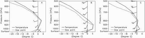
As described above, theoretically, freezing rain events can only form under the specific meteorological conditions of a below-freezing layer close to the ground and an above-freezing layer aloft. Consequently, one question that should be asked of projections of future freezing rain events is whether such special freezing rain-related weather conditions appear in downscaled future climate data. To answer this question, the vertical profiles of downscaled meteorological variables, especially temperature, were evaluated to compare with observed ones. As shown in , as an example, the vertical profiles of temperature, dew point and winds derived from downscaled ECHAM5/MPI-A2 control runs and future outputs at Ottawa are similar to observations. In addition, the seasonal average number of days with a warmer air layer (>0°C) aloft and a colder air layer near the surface was analyzed for observations as well as downscaled GCM control runs and future outputs, derived from the four primary freezing rain-related weather types. From , it is immediately apparent that the number of such days derived from downscaled CGCM2-A2 climate data is very similar to observations. Similar results were also discovered using other downscaled GCM outputs. As a result, it can be concluded that freezing rain-related meteorological conditions exist in downscaled GCM control runs and future climate data.
Table 4. The seasonal average number of the days with a warmer air layer (>0°C) aloft and a colder air layer near the surface within four primary freezing rain-related weather types, as shown by observations (Obs.) as well as downscaled CGCM2-A2 control runs (CR) and future outputs.
Fig. 8 Vertical temperature, dew point, and wind profiles (A) associated with a freezing rain-related weather type on 5 January 1998 at 18:00 utc, (B) from the downscaled ECHAM5/MPI-A2 control runs for 27 January 1973 at 06:00 utc, and (C) from the downscaled ECHAM5/MPI-A2 future climate data for 23 January 2084 at 18:00 utc.
As discussed above, some freezing rain-related meteorological conditions exist in downscaled future GCM climate data. Another question related to this could be asked: can future freezing rain be diagnosed directly from a GCM's vertical temperature profile instead of using the complicated synoptic weather typing and downscaling procedures? There are two major reasons for us to use synoptic weather typing and downscaling methods rather than vertical temperature profiles from a GCM to project changes in frequency of future freezing rain events. First, as described by Rauber et al. Citation(2000), the “classic” freezing rain sounding, with a mid-level warm (>0°C) layer, was observed in only 25% of 972 rawinsonde soundings taken during freezing precipitation. The soundings cover regions of the United States east of the Rocky Mountain States for the period 1970–94. Second, the GCM outputs, due to their coarse spatial and temporal resolutions, are restricted in their usefulness for identification of freezing rain events using their vertical temperature profiles.
5 Conclusions
The overarching purpose of this study was to assess possible changes in future daily freezing rain events in eastern Canada, based on historical relationships between synoptic weather types and freezing rain events as well as downscaled future climate data. Automated synoptic weather typing was employed to determine freezing rain-related weather types, using the observed data record for the period 1958–2007. A variety of downscaled hourly meteorological variables, derived from a regression-based downscaling method, were also used to investigate the possible impacts of climate change on future freezing rain events. The study results show that synoptic weather typing can be an effective method for projecting changes in occurrence frequency of future daily freezing rain events. As pointed out by Cheng et al. Citation(2007), the main advantage of this synoptic weather typing is its ability to take into account the critical weather information and complex physical process of freezing rain formation, including a suite of various weather elements with hourly time resolutions over the surface and vertical profiles.
The projected results clearly show that in the coldest months, eastern Canada could possibly receive more freezing rain events in the future than was historically experienced during the period 1958–2007. The increase in the number of daily freezing rain events could be progressively greater from south to north or from southwest to northeast across eastern Canada. For example, the percentage increase for severe freezing rain events (≥6 h per day) is projected to be about 35% in Region I and about 80% in Region II by the period 2081–2100. The corresponding percentage increases for Regions V and VI could be about 80% and 100%, respectively. In the Atlantic Provinces, the corresponding percentage increase in Region III (Newfoundland; 50%) is greater than that in Region IV (the southern Atlantic Provinces; 20%). The implication of these increases should be taken into consideration when adjusting engineering infrastructure requirements and developing adaptation strategies and policies. This study is intended to provide the municipalities in eastern Canada with scientific information needed to improve the adaptive capacity of the infrastructure at risk of being impacted by freezing rain and mitigate the long-term risks to people, property and communities, from the effects of a changing climate.
As described above, the current study focused on projections of changes in frequency and severity of future daily freezing rain events. The number of hours during a day when freezing rain occurs (e.g., ≥4 h or ≥6 h) was applied as a measure of the severity of daily freezing rain events. The icing amount or ice load during freezing rain events is another important indicator of freezing rain severity, which was not considered in the current study. However, the methods used in this study have the potential to be employed with daily icing amounts derived from an ice accretion model to project changes in future icing amounts. To achieve this, future research should address two major issues. First, an ice accretion model needs to be developed and validated to make sure the model is able to simulate historical icing amounts. Second, it is necessary to investigate the feasibility of applying the ice accretion model to project future icing amounts using downscaled future climate data.
Considerable effort was made in this study to transfer GCM-scale climate data to station-scale climate information using regression-based downscaling transfer functions. These downscaling transfer functions, using the past 50-year relationships between regional-scale predictors and station-scale weather elements, are able to remove much of the GCM model bias (Katz, Citation2002). Consequently, the quality of the projected future climate data, following downscaling, was much improved. In fact, the extreme characteristics of the weather variables, seasonal and diurnal variations, and data distribution from downscaled GCM control runs are very similar to observations over the time period 1961–2000. In addition, any differences between freezing rain projections driven by downscaled GCM control runs and observations were considered for further correction of future freezing rain projections.
However, conclusions made in this study about the impacts of climate change on future freezing rain still rely on GCM outputs and, as a result, there is corresponding uncertainty about the future freezing rain projections of this study. One of the most important sources of uncertainty in climate change impact studies comes from GCM modelling. Due to model resolution and complexity, the GCM models must have inevitably omitted some factors that affect climate. Although some degree of GCM uncertainty remains in the assessment of changes in future daily freezing rain events, the future projections for the coldest months (monthly grouping Equation(1)) derived from all downscaled GCM outputs used in the study showed a pattern of consistent increase across the study area. This suggests that uncertainty in future projected changes in daily freezing rain events might not be an important issue, and eastern Canada is most likely to experience more freezing rain events in the middle and late part of this century.
References
- Changnon , S. A. 2004 . Climate atlas:Freezing rain and ice storms Ashville, North Carolina: Printec Press. Available from: National Climatic Data Center, 151 Patton Ave., Asheville, NC, 28801–5001 or http://ols.nndc.noaa.gov/plolstore/plsql/olstore.prodspecific?prodnum=C00590-PUB-A0001
- Cheng , C. S. and Kalkstein , L. S. 1997 . Determination of climatological seasons for the East Coast of the U.S. using an air mass-based classification . Clim. Res. , 8 : 107 – 116 .
- Cheng , C. S. , Auld , H. , Li , G. , Klaassen , J. , Tugwood , B. and Li , Q. 2004 . An automated synoptic typing procedure to predict freezing rain: An application to Ottawa, Ontario . Weather Forecast , 19 : 751 – 768 .
- Cheng , C. S. , Auld , H. , Li , G. , Klaassen , J. and Li , Q. 2007 . Possible impacts of climate change on freezing rain in south-central Canada using downscaled future climate scenarios . Nat. Hazards Earth Syst. Sci. , 7 : 71 – 87 .
- Cheng , C. S. , Li , G. , Li , Q. and Auld , H. 2008 . Statistical downscaling of hourly and daily climate scenarios for various meteorological variables in south-central Canada . Theor. Appl. Climatol. , 91 : 129 – 147 . doi: 10.1007/s00704-007-0302-8
- Cheng , C. S. , Li , G. , Li , Q. and Auld , H. 2010 . A synoptic weather typing approach to simulate daily rainfall and extremes in Ontario, Canada: potential for climate change projections . J. Appl. Meteorol. Climatol. , 49 : 845 – 866 . doi: 10.1175/2010JAMC2016.1
- DeGaetano , A. T. , Belcher , B. N. and Spier , P. L. 2008 . Short-term ice accretion forecasts for electric utilities using the weather research and forecasting model and a modified precipitation-type algorithm . Weather Forecast , 23 : 838 – 853 .
- Dore , M. H. I. 2003 . Forecasting the conditional probabilities of natural disasters in Canada as a guide for disaster preparedness . Nat. Hazards , 28 : 249 – 269 .
- Environment Canada . 2007a . Data: Canadian Centre for Climate Modelling and Analysis — CGCM1 and CGCM2 runs forcing . Retrieved from http://www.cccma.bc.ec.gc.ca/data/cgcm/cgcm_forcing.shtml
- Environment Canada . 2007b . Data: Canadian Centre for Climate Modelling and Analysis — CGCM3 forcing . Retrieved from http://www.cccma.bc.ec.gc.ca/data/cgcm3/cgcm3_forcing.shtml
- Environment Canada . 2007c . Data: Canadian Centre for Climate Modelling and Analysis . Retrieved from http://www.cccma.bc.ec.gc.ca/data/data.shtml
- Houston , T. G. and Changnon , S. A. 2007 . Freezing rain events: a major weather hazard in the conterminous US . Nat. Hazards , 40 : 485 – 494 .
- Katz , R. W. 2002 . Techniques for estimating uncertainty in climate change scenarios and impact studies . Clim. Res. , 20 : 167 – 185 .
- Makkonen , L. 1998 . Modeling power line icing in freezing precipitation . Atmos. Res. , 46 : 131 – 142 .
- McKay , G. A. and Thompson , H. A. 1969 . Estimating the hazard of ice accretion in Canada from climatological data . J. Appl. Meteorol. , 8 : 927 – 935 .
- PCMDI (Program for Climate Model Diagnosis and Intercomparison) . 2007 . About the WCRP CMIP3 multi-model dataset archive at PCMDO . Retrieved from http://www.cmdi.llnl.gov/ipcc/about_ipcc.php
- Rauber , R. M. , Olthoff , L. S. , Ramamurthy , M. K. and Kunkel , K. E. 2000 . The relative importance of warm rain and melting processes in freezing precipitation events . J. Appl. Meteorol. , 39 : 1185 – 1195 .
- Regan , M. 1998 . Canadian ice storm 1998 . WMO Bull. , 47 : 250 – 256 .
- Ryerson , C. and Ramsay , A. C. 2007 . Quantitative ice accretion information from the automated surface observing system . J. Appl. Meteorol. Climatol. , 46 : 1423 – 1437 .
- Shen , S. S.P. , Dzikowski , P. , Li , G. and Griffith , D. 2001 . Interpolation of 1961–97 daily temperature and precipitation data onto Alberta polygons of ecodistrict and soil landscapes of Canada . J. Appl. Meteorol , 40 : 2162 – 2177 .
- Stuart , R. A. and Isaac , G. A. 1999 . Freezing precipitation in Canada . Atmosphere-Ocean , 37 : 87 – 102 .
- Yarnal , B. 1993 . Synoptic Climatology in Environment Analysis London, UK: Belhaven Press
- Yip , T. C. 1995 . Estimating icing amounts caused by freezing precipitation in Canada . Atmos. Res. , 36 : 221 – 232 .