Abstract
Using outgoing longwave radiation (OLR) data as a proxy for tropical convection, the relationship between the Madden-Julian Oscillation (MJO)-related tropical convection and North American winter surface air temperature (SAT) is investigated. A lagged regression analysis between one of the leading OLR principal components (PCs) and SAT shows highly significant correlations over south-southeastern Canada, with the strongest SAT anomalies occurring at a lag of 2 to 3 pentads. The lagged temperature composite shows an extensive intensified positive SAT anomaly over southern Canada and the northern United States 10–15 days after the occurrence of enhanced convection over the Indian Ocean and the Maritime Continent and reduced convection near the tropical central Pacific. The lagged regressions of 500 hPa geopotential height with the OLR PC reveal a wave train propagating from the tropics to North America. This observation has been reproduced in a simple general circulation model (SGCM) with an idealized forcing that mimics the tropical MJO convection anomaly. A simple regression model is constructed to predict winter SAT over North America with tropical MJO convective activity as the single predictor. Under a cross-validation framework, this statistical model produces 10–15 day SAT forecasts with modest, yet statistically significant, skill in winter over North America.
R ésumé [Traduit par la rédaction] En utilisant les données de rayonnement sortant de grandes longueurs d'onde (RGLO) comme données indirectes de convection tropicale, nous étudions la relation entre la convection tropicale liée à l'oscillation Madden-Julian (OMJ) et la température de l'air à la surface (TAS) en hiver en Amérique du Nord. Une analyse de régression décalée entre l'une des premières composantes principales (CP) du RGLO et la TAS révèle des corrélations très nettes dans le sud-sud-est du Canada, les plus fortes anomalies de TAS se produisant avec un décalage de 2 à 3 pentades. La carte composite décalée des températures montre une vaste anomalie positive intensifiée de TAS dans le sud du Canada et le nord des États-Unis de 10 à 15 jours après qu'une convection accentuée au-dessus de l'océan Indien et du Continent maritime et qu'une convection réduite près du Pacifique central tropical se soient produites. Les régressions décalées de la hauteur géopotentielle à 500 hPa avec la CP du RGLO font voir un train d'ondes se propageant des tropiques vers l'Amérique du Nord. Cette observation s'est reproduite dans un modèle de circulation générale simple (MCGS) avec un forçage idéalisé qui imite l'anomalie de convection tropicale OMJ. Nous construisons un modèle de régression simple pour prévoir la TAS en hiver en Amérique du Nord avec l'activité convective tropicale OMJ comme prédicteur unique. Dans un cadre de validation croisée, ce modèle statistique produit des prévisions de TAS de 10 à 15 jours avec une habileté modeste, mais statistiquement significative, en hiver en Amérique du Nord.
1 Introduction
The near-surface air temperature (SAT) is an important factor in human lives and, in particular, extreme temperature events can have serious adverse environmental and economic impacts. Understanding the dynamics and making accurate forecasts of SAT anomalies on a submonthly time scale are therefore of great importance for social and economic activities.
Low frequency atmospheric and oceanic variability in the tropics can have a significant influence on cold season climate variability over various regions of North America through the propagation of Rossby waves that take the form of teleconnection patterns (Wallace and Gutzler, Citation1981). In particular, a number of studies have shown that the El Niño-Southern Oscillation (ENSO) plays a dominant role in Canadian temperature anomalies in winter and spring (Halpert and Ropelewski, Citation1992; Shabbar and Barnston, Citation1996; Shabbar and Bonsal, Citation2004). Diabatic heating in the central and eastern tropical Pacific can trigger Rossby waves that give rise to the Pacific-North American teleconnection (PNA) pattern (e.g., Wallace and Gutzler, Citation1981; Shabbar and Skinner, Citation2006). Szeto's Citation(2008) investigation of the extreme variability and change in cold-season temperatures in northwestern Canada indicated that the large winter temperature variability in this region is mainly a result of the strong variability in atmospheric circulations over the North Pacific. Because North America's weather is influenced by the PNA pattern, which is linked in part to tropical forcing, diabatic heating conditions in the tropical Pacific can be used as a source of predictability over parts of Canada, at least on the seasonal time scale (e.g., Derome et al., Citation2001). In this study, we will examine the potential for shorter term predictability arising from tropical heat sources.
The Madden-Julian Oscillation (MJO), which has a time scale of 30–60 days, has long been recognized as a major large-scale tropical signal (Madden and Julian, Citation1971) and is the dominant source of intraseasonal variability in the tropics. Tropical-extratropical interaction associated with the 30–60 day oscillation has a significant impact on the extratropical atmospheric circulation and contributes to sub-seasonal weather predictability (Ferranti et al., Citation1990; Waliser et al., Citation1999, Citation2003). In a recent study, Lin and Brunet Citation(2009) (hereafter LB2009) analyzed historical daily SAT data for 210 relatively evenly distributed stations across Canada and found that winter SAT has a significant dependence on the phase of the MJO, implying that the MJO phase could contain important information for extended-range forecasting of winter SAT. In this study, we explore the possibility of using the MJO signal as a predictor for North American winter SAT. As the signal of the tropical diabatic forcing associated with MJO would take about a week to propagate to North America (e.g., Lin et al., Citation2007a), we will consider the time-lagged association between SAT and tropical convection to improve our understanding of how this slowly changing organized tropical convection is linked to North American intraseasonal temperature variability. We will then examine whether a statistical model that uses information about the tropical convection as a predictor can predict winter SAT over North America on a submonthly time scale with significant skill.
2 Data and methodology
The data used here as an inverse measure of tropical convection are the daily averaged outgoing longwave radiation (OLR) data from the National Oceanic and Atmospheric Administration's (NOAA) polar orbiting series of satellites (Liebmann and Smith, Citation1996). Daily averaged SAT and 500 hPa geopotential height from the National Centers for Environmental Prediction/National Center for Atmospheric Research (NCEP/NCAR) global reanalysis (Kalnay et al., Citation1996) are also used. These data are provided by NOAA (2010). The resolution for the NCEP/NCAR reanalysis and OLR data is 2.5° × 2.5°.
The daily values of the NCEP/NCAR reanalysis and OLR data are averaged over a consecutive non-overlapping five-day period to construct pentad data. Winter is defined here to be the months of December, January and February (DJF). The analysis is conducted for 29 winters from 1979/80 to 2007/08 with each winter containing 18 pentads, starting from the pentad of 2–6 December, giving a total of 522 pentads. The last pentad of each winter always covers the period 25 February to 1 March, whether or not it is a leap year. Thus, in the case of a leap year, the data for that “pentad” is actually an average over six days.
The seasonal cycle, defined here as the time mean and the first two harmonics of the 29-year pentad climatology, is first removed for each grid point. Because we want to focus on the intraseasonal variability, the mean for each winter is then removed in order to eliminate its contribution to the interannual variability.
To represent the MJO and identify the tropical convection patterns, an empirical orthogonal function (EOF) analysis is performed on the winter OLR pentad from 1979 to 2008. The area used here is 25°S–25°N and 60°E–180°E where the tropical convection and its variability are strong. The spatial distributions of the two leading modes that explain 14.9% and 10.2% of the total variance, respectively, are shown in . A large convection anomaly is seen around the South China Sea and Indonesia in the first mode (. A dipole structure of convection anomalies, one located in the eastern Indian Ocean and the other in the western Pacific, is found in the second mode (. The principal components (PCs) of the two EOFs have a power spectrum peak (not shown) at around eight pentads. The cross-correlation between PC1 and PC2 reaches its maximum at a lag of two pentads. The above features indicate that the two leading EOFs together represent the eastward propagating MJO disturbance. In fact, these two leading EOFs are very similar to the OLR components of the combined EOF analysis of Wheeler and Hendon Citation(2004). PC1 and PC2 are highly correlated with the Real-time Multivariate MJO (RMM) indices of Wheeler and Hendon Citation(2004). The correlation between PC1 and RMM1 is 0.51 and that between PC2 and RMM2 is -0.77.
Fig. 1 The two leading EOF modes of OLR, a) EOF1 and b) EOF2. The contour interval is 0.03. Contours with negative values are dashed.
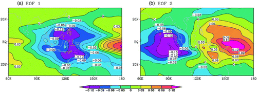
In LB2009, the RMM index was used to define the phases of the MJO and composite analyses were conducted for each phase of the MJO. It was found that the Canadian SAT depends on the phase of the MJO, and phases 3 and 7 have the strongest influence. These two phases have a dipole tropical convection anomaly structure ( of LB2009) similar to our EOF2 (. However, how the amplitude of the MJO in each phase contributes was unclear. In this study, we will make use of PC2 to focus on the connection between North American SAT and the amplitude of this mode.
3 Connection between North American SAT and the MJO
a Lagged Regression
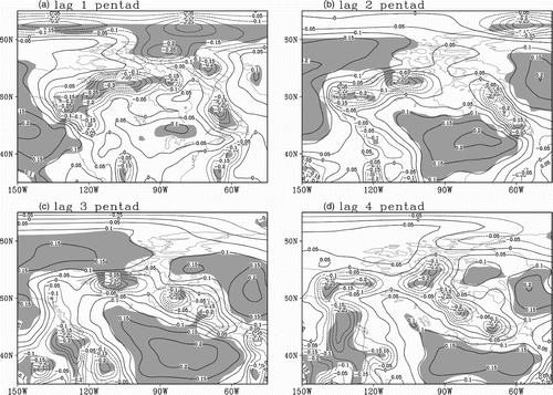
In an attempt to see the relationship between the tropical convection and the North American winter SAT anomaly, the lagged regressions between the leading OLR PCs and winter SAT were calculated, with lag n meaning that the SAT anomaly lags the OLR PC by n pentads.
PC1 has no significant correlation with North American SAT (not shown). This agrees with LB2009 who found that only phases 3 and 7 of the MJO have a significant impact on North American SAT. These two phases have a similar tropical convection distribution to EOF2. The lagged regression coefficients of SAT with respect to PC2 are shown in . The magnitude represents a SAT anomaly corresponding to one standard deviation of PC2. Shading shows the areas where the regression is statistically significant at the 0.01 level according to a Student's t-test. Indeed, highly significant correlations are found over parts of North America. One pentad after the tropical convective activities of a positive PC2, significant positive SAT anomalies appear over central North America (. At lag 2, the area expands westward and southward ( and then moves somewhat southward at lag 3 (. At the same time, negative SAT anomalies develop over northeastern Canada. By lag 4, the anomaly area shrinks and weakens (. The strongest SAT response to tropical convection is thus found at a lag of 2–3 pentads. This time lag is consistent with previous studies (e.g., Jin and Hoskins, Citation1995; Lin et al., Citation2007a) that showed a maximum extratropical response to tropical forcing after about two weeks.
Fig. 2 Lagged regression between the OLR second principal component and winter SAT over North America. The contour interval is 0.2°C. Contours with negative values are dashed. Shading represents areas where the correlation is statistically significant at the 0.01 level. The magnitude of the SAT anomalies corresponds to one standard deviation of PC2 time series.
b Lagged Composites
The above lag regressions represent a linear connection. To further verify the relationship between the tropical convection and the winter SAT anomaly over North America and to see if some non-linearity exists in the relationship, two groups of pentad winter SAT data were selected from PC2 of the OLR. One group had a PC2 value greater than one standard deviation, which we call the “above-normal” PC2 pentads, whereas the pentads with a “below-normal” PC2 are those with PC2 smaller than minus one standard deviation. Then, according to the time of the above- and below-normal convection activities, two corresponding SAT datasets were selected and the average SAT anomaly of each one was calculated. The results of this calculation then show the average SAT anomaly distribution in North America when there are anomalous convective activities of EOF2 of each sign. The calculations were done with the SAT anomaly lagging PC2 by 1–4 pentads. Again, lag n means that the SAT anomaly lags the PC2 anomaly by n pentads.
to 3d illustrate the SAT composites for the positive PC2. The overall structure is similar to the regression maps (), i.e., positive SAT anomalies in central North America and negative values in the northern regions. The positive SAT anomalies are highly significant for lags 1–3, whereas the negative SAT anomalies are not, except those over Alaska. One pentad after a positive PC2 (, a positive winter SAT anomaly appears in central North America, just to the south of the Great Lakes, with a maximum amplitude of 1.6°C. At lag 2, the SAT anomaly expands and reaches an amplitude of 2.2°C (. Then the positive SAT anomaly region decreases in size and its intensity becomes weaker and moves southward at lag 3 (. The whole temperature response disappears at lag 4 (. For those cases where the enhanced convection occurs over the western Pacific and reduced convection is found in the eastern Indian Ocean (negative PC2; to 3h), the associated SAT anomalies are negative over central North America and positive in the northern regions. This time, however, the SAT anomalies over central North America are not statistically significant, except for a small area in the southeastern United States at lag 4.
Fig. 3 Lagged composites of SAT deviation. The contour interval is 0.2°C. Contours with negative values are dashed. Shading represents areas where the composite anomaly is different from zero at a 0.05 significance level according to a Student's t-test. The left panels show cases when the OLR PC2 is above one standard deviation, whereas the right panels show cases when it is lower than minus one standard deviation.
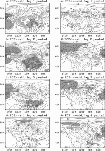
In contrast to the opposite-signed anomalies, the positive SAT anomalies over the northern regions are significant. This non-linearity of SAT anomalies is consistent with the findings of LB2009. We also note that despite the significance level, the overall association of winter North American SAT with respect to tropical convection activities is quite linear, i.e., positive and negative PC2s are related to opposite phases of a dipole structure of SAT anomalies with one centre over central North America and another in the northern part of the continent. This suggests that a simple linear regression model, which will be discussed in Section 5, could capture the main features of the tropical-extratropical connection.
4 Physical explanation
a Large-scale Circulation Anomalies
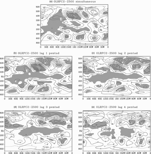
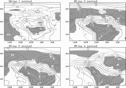
In this section we present the regressions between the tropical OLR and the geopotential height at 500 hPa to shed some light on the mechanism relating tropical convection to wintert SAT over North America. From their simultaneous and lagged regression patterns we can see () that a geopotential wave train originates in the Indian Ocean and western Pacific area and propagates northeastward. The most significant correlation occurs at lags 2 and 3 ( and ) and remains small and positive at lag 4. This result is consistent with previous studies showing that the tropical forcing in the Pacific region can influence the North American climate through a northeastward flux of wave activity (Harnack et al., 1984; Matthews et al., Citation2004; Lin et al., Citation2007b, Citation2009; Moore et al., Citation2010).
b Numerical Model Simulation
It has been demonstrated that the simple general circulation model (SGCM) of Hall Citation(2000) can successfully simulate the mean circulation and variability in the northern hemisphere (e.g., Hall and Derome, Citation2000; Lin et al., Citation2007a, Citation2007b). Here we use this model to further investigate the relationship between tropical convection and winter SAT anomalies over North America. In brief, it is a global spectral model with no moisture representation. The resolution used in this study is T31 with 10 vertical levels. A detailed description of the model parameters can be found in Hall and Derome Citation(2000). To simulate the convection pattern in , numerical experiments are conducted here with one negative heating forcing added in the western Pacific area and one positive heating forcing over the eastern Indian Ocean (. The heating perturbation mimics deep convection and has an elliptical form in the horizontal, with semi-major and semi-minor axes of 30 degrees longitude and 12.5 degree latitude. The magnitude of the heating is proportional to the squared cosine of the distance from the centre. The heating anomaly has a vertical profile of (1-σ)sin(π(1- σ)), which peaks at σ = 0.35 with a vertically averaged heating rate at the centre of 2.5 K d−1, where σ is a pressure divided by surface pressure. This rate is equivalent to a latent heating associated with precipitation of 1 cm d−1(e.g., Jin and Hoskins, Citation1995). The tropical heating anomaly that is added to the temperature equation is switched on at t = 0 and persists during the integration.
Fig. 5 (a) Vertical averaged anomalous heating rate in the simulation. (b) 500 hPa geopotential height response at day 15. The contour interval is 0.1°C d−1 for (a) and 15 m for (b).
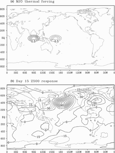
A linear integration of this model is conducted as described in Hall and Derome Citation(2000). The basic state is chosen to be the model climate of a long perpetual winter integration. The linear response of the SGCM to the simple tropical forcing at day 15 at 500 hPa is shown in . Comparing this result to the regression map between the observed principal component of PC2 and the 500 hPa geopotential height (), we see that while the model high pressure cell over the North Pacific is too strong, the model day 15 output over North America matches the observed regression pattern at lags 1 and 2 rather well. The 950 hPa air temperature responses on days 10 and 15 are shown in and . As can be seen, the main features of the observed SAT pattern () are reasonably well reproduced.
5 Linear regression model for SAT prediction
The previous results suggest that tropical convection could be used as a predictor of SAT over parts of North America some 10–15 days later. To test this possibility we construct a linear regression forecast model to predict North American SAT with estimates of the organized tropical convection as a predictor.
The principle of the cross-validation method is to delete one or more cases in a dataset systematically, train a forecast model from the remaining cases, and then test it on the deleted case or cases (Michaelsen, Citation1987). In this paper, PC2 of the OLR and winter SAT data are used to construct the regression forecast model. One year of data (the year to be forecast) is deleted from both time series. PC2 and SAT data for the remaining years are used to calculate the regression coefficients for the regression forecast model. Then, using the forecast model, PC2 of the deleted year is taken as the predictor to forecast the SAT anomaly at each pentad in the same forecast year. The regression model we use here is simply:
To test the skill of this forecast model, the temporal correlation between the forecast and observed SAT anomalies is calculated at each grid point in space. The correlation coefficients are shown in . For the North American area, only very small scattered correlation regions exist at lag 1 (. But for lags 2 to 4 large areas of small but statistically significant correlations are found ( to 7d). The most highly correlated region is seen over south-central and southeastern Canada and the north-central and southeastern United States. The best forecast time scale is for lags 2 and 3 ( and ). While statistically significant (in part due to the large number of samples), the correlations are small. It is therefore doubtful that the statistical model could be of practical use in operational forecasting. On the other hand, this may be a limitation of the linearity assumption built into the model, an assumption not strongly supported by our composite analysis (). It is possible that a non-linear model would be of practical use, but that remains to be shown. Similarly, it is quite possible that a numerical weather prediction model, which intrinsically includes non-linear effects, could make practical use of the observed link between the MJO and North American SAT to produce useful extended range temperature forecasts.
6 Conclusions and discussion
The contribution of the organized tropical convection to submonthly winter SAT anomalies over North America was examined in this study. Twenty-nine years (1979–2008) of OLR pentad data over the tropical eastern Indian Ocean and western Pacific were used as a proxy for the MJO-related tropical convection. The lagged regression between the OLR PC and winter SAT was calculated with results showing a significant positive SAT anomaly over south-central Canada. The strongest SAT anomalies occur at lag 2–3 after the tropical convection. The lagged winter SAT composites associated with above- and below-normal convection activity indicate an extensive intensified positive SAT anomaly over southern Canada and the northern United States 10–15 days after above-normal tropical convection. No significant SAT anomaly signal was found over North America when the convection was below normal in the Indian Ocean and above normal in the western Pacific. Lagged regressions of the convection PC and 500 hPa geopotential height reveal northeastward propagating wave activity from the tropics to North America. The SGCM was further utilized to investigate the response to tropical forcing. To mimic the second tropical EOF mode, which is the MJO-related convection signal, two heat forcing anomalies, one negative in the western Pacific and one positive in the eastern Indian Ocean, were added to the model. The simulation results revealed a northeastward propagation of wave activity forced by this tropical forcing. The wave propagated from the tropical ocean area to North America in about 15 days. In an attempt to test the forecast skill of tropical convective activity as a predictor of winter SAT in North America, the OLR PC was used as the predictor to set up a regression model, and a cross-validation technique was used to forecast the 29 years of SAT anomalies in North America. Results showed that the statistical model had some modest skill in predicting SAT 10–15 days in advance. While the forecast skill is modest, the results suggest that if other sources of predictability were taken into account, either in statistical models or in numerical weather prediction models, it may be possible to produce useful time-averaged SAT forecasts at a range of 10 to 15 days for parts of North America. For example, the North Atlantic Oscillation is known to have an effect on SAT in parts of North America (Hurrell, Citation1996), but this has not been taken into account in this study.
A recent study (Lin et al., Citation2010) demonstrated that the MJO also has a significant effect on winter precipitation in Canada. This gives further evidence that the MJO convection activity provides important information for extended-range weather forecasting in North America. How to represent such information in numerical models better in order to improve the predictions is an interesting topic for future research.
Acknowledgements
The authors would like to acknowledge the support provided by research grants from the Canadian Foundation for Climate and Atmospheric Sciences (CFCAS) and the Natural Sciences and Engineering Research Council of Canada (NSERC).
Additional information
Notes on contributors
Wenqing Yao
Current affiliation: Chinese Academy of Meteorological Sciences, Beijing, ChinaReferences
- Derome , J. , Brunet , G. and Wang , Y. 2001 . On the potential vorticity balance on an isentropic surface during normal and anomalous winters . Mon. Weather Rev. , 129 : 1208 – 1220 .
- Ferranti , L. , Palmer , T. N. , Molteni , F. and Klinker , E. 1990 . Tropical-extratropical interaction associated with the 30–60 day oscillation and its impact on medium and extended range prediction . J. Atmos. Sci. , 47 : 2177 – 2199 .
- Hall , N. M. J. 2000 . A simple GCM based on dry dynamics and constant forcing . J. Atmos. Sci. , 57 : 1557 – 1572 .
- Hall , N. M.J. and Derome , J. 2000 . Transients, nonlinearity, and eddy feedback in the remote response to El Niño . J. Atmos. Sci. , 57 : 3992 – 4007 .
- Halpert , M. S. and Ropelewski , C. F. 1992 . Surface temperature patterns associated with the Southern Oscillation . J. Clim. , 5 : 577 – 593 .
- Harnack , R. P. and Crane , M. W. 1984 . Intraseasonal tropospheric circulation variability and its association with concurrent atmospheric and oceanic fields . Mon. Weather Rev. , 112 : 1768 – 1781 .
- Hurrell , J. W. 1996 . Influence of variations in extratropical wintertime teleconnections on northern hemisphere temperature . Geophys. Res. Lett. , 23 ( 6 ) : 665 – 668 .
- Jin , F. and Hoskins , B. J. 1995 . The direct response to tropical heating in a baroclinic atmosphere . J. Atmos. Sci. , 52 : 307 – 319 .
- Kalnay , E. , Kanamitsu , M. , Kistler , R. , Collins , W. , Deaven , D. , Gandin , L. , Iredell , M. , Saha , S. , White , G. , Woollen , J. , Zhu , Y. , Leetmaa , A. , Reynolds , B. , Chelliah , W. , Ebisuzaki , M. , Higgins , W. , Janowiak , J. , Mo , K. C. , Ropelewski , C. , Wang , J. , Jenne , R. and Jospeh , D. 1996 . The NCEP/NCAR 40-year reanalysis project . Bull. Amer. Meteorol. Soc. , 77 : 437 – 471 .
- Liebmann , B. and Smith , C. A. 1996 . Description of a complete (interpolated) outgoing longwave radiation dataset . Bull. Am. Meteorol. Soc. , 77 : 1275 – 1277 .
- Lin , H. , Derome , J. and Brunet , G. 2007a . The nonlinear transient atmospheric response to tropical forcing . J. Clim. , 20 : 5642 – 5665 .
- Lin , H. , Brunet , G. and Derome , J. 2007b . Intraseasonal variability in a dry atmospheric model . J. Atmos. Sci. , 64 : 2422 – 2441 .
- Lin , H. and Brunet , G. 2009 . The influence of the Madden-Julian oscillation on Canadian wintertime surface air temperature . Mon. Weather Rev. , 137 : 2250 – 2262 .
- Lin , H. , Brunet , G. and Derome , J. 2009 . An observed connection between the North Atlantic oscillation and the Madden-Julian oscillation . J. Clim. , 22 : 364 – 380 .
- Lin , H. , Brunet , G. and Mo , R. 2010 . Impact of the Madden-Julian Oscillation on wintertime precipitation in Canada . Mon. Weather Rev , 138 : 3822 – 3839 .
- Madden , R. A. and Julian , P. R. 1971 . Description of a 40–50 day oscillation in the zonal wind in the tropical Pacific . J. Atmos. Sci. , 28 : 702 – 708 .
- Matthews , A. J. , Hoskins , B. J. and Masutani , M. 2004 . The global response to tropical heating in the Madden-Julian Oscillation during northern winter . Q. J. R. Meteorol. Soc. , 130 : 1991 – 2011 .
- Michaelsen , J. 1987 . Cross-validation in statistical climate forecast models . J. Clim. Appl. Meteorol. , 26 : 1589 – 1600 .
- Moore , R. W. , Martius , O. and Spengler , T. 2010 . The modulation of the subtropical and extratropical atmosphere in the Pacific Basin in response to the Madden–Julian Oscillation . Mon. Weather Rev , 138 : 2761 – 2779 .
- NOAA (National Oceanic and Atmospheric Administration) . 2010 . Reanalysis datasets at PSD [Data] . Retrieved from http://www.esrl.noaa.gov/psd/data/gridded/reanalysis/
- Shabbar , A. and Barnston , A. G. 1996 . Skill of seasonal climate forecasts in Canada using canonical correlation analysis . Mon. Weather Rev. , 124 : 2370 – 2385 .
- Shabbar , A. and Bonsal , B. 2004 . Associations between low frequency variability modes and winter temperature extremes in Canada. Atmosphere-Ocean . 42 : 127 – 140 .
- Shabbar , A. and Skinner , W. 2006 . The impact of El Niño-Southern oscillation on the Canadian climate . Adv. Geosci. , 6 : 149 – 153 .
- Szeto , K. K. 2008 . On the extreme variability and change of cold-season temperatures in northwest Canada . J. Clim. , 21 : 94 – 113 .
- Waliser , D. E. , Jones , C. , Schemm , J. K. and Graham , N. E. 1999 . A statistical extended-range tropical forecast model based on the slow evolution of the Madden-Julian oscillation . J. Clim. , 12 : 1918 – 1939 .
- Waliser , D. E. , Lau , K. M. , Stern , W. and Jones , C. 2003 . Potential predictability of the Madden-Julian oscillation . Bull. Am. Meteorol. Soc. , 84 : 33 – 50 .
- Wallace , J. M. and Gutzler , D. S. 1981 . Teleconnections in the geopotential height field during the northern hemisphere winter . Mon. Weather Rev. , 109 : 784 – 812 .
- Wheeler , M. and Hendon , H. 2004 . An all-season real-time multivariate MJO index: Development of an index for monitoring and prediction . Mon. Weather Rev. , 132 : 1917 – 1932 .
