Abstract
The recent 1999–2004 drought, and especially the period from 2001 to 2002, had major impacts across Canada and in the western Canadian Prairie region in particular. This study characterizes the recent drought with respect to precipitation on a small scale at three sites: Calgary, Edmonton and Saskatoon. Climatologically, precipitation events of low daily accumulation (≤0 mm) account for the majority of the total accumulation (up to 58%) at all study locations. During the recent drought, these events contributed a higher proportion of the total precipitation (up to 63%) because of a lack of heavy precipitation events. Using radar data at these locations, precipitation events were also classified into three categories: convective, stratiform and virga. There was wide variation in the relative importance of stratiform and convective precipitation at the sites with, for example, some drought periods being dominated by convective and others by stratiform events. Virga was also present with an average cloud base temperature <0°C which would have led to efficient sublimational loss contributing to the reduction of precipitation at the surface. Any understanding of drought must take into account such precipitation issues.
R ésumé [Traduit par la rédaction] La récente sécheresse de 1999–2004, et plus spécialement la période de 2001 à 2002, a eu des répercussions majeures au Canada en général et dans la région des Prairies canadiennes en particulier. La présente étude caractérise cette sécheresse récente en fonction des précipitation à petite échelle à trois sites : Calgary, Edmonton et Saskatoon. D'un point de vue climatologique, les événements de précipitations de faible accumulation journalière (≤10 mm) comptent pour la majorité de l'accumulation totale (jusqu'à 58 %) à tous les endroits étudiés. Durant la récente sécheresse, ces événements ont constitué une plus grande proportion des précipitations totales (jusqu'à 63 %) à cause du faible nombre d'événements de fortes précipitations. À l'aide des données radar à ces endroits, les événements de précipitation ont aussi été classifiées en trois catégories : convective, stratiforme et virga. Il y a eu une grande variation de l'importance relative des précipitations stratiformes et convectives à ces sites avec, par exemple, certaines périodes de sécheresse dominées par des événements convectifs et d'autres par des événements stratiformes. Il y a eu aussi des virgas avec une température moyenne de la base des nuages <0°C, ce qui aurait causé des pertes par sublimation contribuant à la réduction des précipitations à la surface. Pour comprendre toute sécheresse on doit prendre en compte ce genre de facteurs liés aux précipitations.
Keywords:
1 Introduction
Drought is a deceptively destructive natural phenomenon and has been touted as a “catastrophic non-event” (Weber and Nkemdirim, Citation1998). What can start as a seemingly benign weather pattern may evolve into an unfortunate manifestation of extreme weather (expressed as a lack of climatologically expected precipitation) commonly known as a “drought.” In its wake, a severe drought has the potential to leave vast devastation. The impact of a severe drought is normally widespread (Quiring and Papakyriakou, Citation2005), affecting both the physical environment and the viability of socioeconomic activities such as agriculture and agri-food production, water resource management, industrial processes, and municipal and commercial water use. In some drought-prone regions, repeated ravaging of the landscape through desiccation by severe drought renders agricultural productivity extremely difficult, if not impossible.
It is well documented that precipitation on the Canadian Prairies is highly variable and that drought is relatively common (e.g., Dey, Citation1982; Phillips, Citation1990; Maybank et al., Citation1995; Akinremi and McGinn, Citation1999; Bonsal et al., Citation1999; Bonsal and Wheaton, Citation2005). In some regions, such as southern Alberta and southwestern Saskatchewan, average growing season accumulations only provide marginally sufficient moisture to meet crop demands (Bonsal et al., Citation1999) even though this period climatologically produces the greatest amount of precipition (Longley, Citation1972; Dey, Citation1982). Thus, any shortfall in precipitation, especially during the critical growing season, has a severe impact on agricultural productivity.
Much of the research directed toward understanding such droughts has focused on large-scale atmospheric patterns. Various teleconnection indices (see Wallace and Gutzler, Citation1981) have been studied with respect to their correlation with precipitation patterns seen over North America. For example, Shabbar and Skinner Citation(2004) found that Pacific sea surface temperatures (SSTs), as defined by the El-Niño Southern Oscillation (ENSO), as well as the Pacific Decadal Oscillation in the preceding winter, strongly modulated precipitation deficits and surpluses during the following summers, particularly over western Canada. In addition, it has been shown that amplified ridging extending north from the western United States is almost invariably associated with dry conditions across the Prairies (see for example Dey, Citation1982; Knox and Lawford, Citation1990).
Other studies have focused on the transport of moisture into the region. Liu et al. Citation(2004) showed that the anomalous ridging in western North America was associated with a significant deficit in the moisture transport into the Prairies from the Gulf of Mexico. This moisture deficit is exacerbated by a lack of enhanced moisture transport from the Pacific, collectively resulting in extremely dry surface conditions. Subsequent research performed by Dominguez and Kumar Citation(2005) focused on the moisture transport characteristics associated with wet and dry conditions in the central United States. While these patterns were shown not to be the inverses of one another, dry conditions in the United States were also associated with a deficit in moisture transport from the Gulf of Mexico.
Given the major impacts of drought, there is a strong motivation to understand its sustaining mechanisms and to characterize its behaviour better. It is not just important to examine large-scale factors; small scale-factors operating over the land area experiencing drought also affect the critical cycling of water. For example Roberts et al. Citation(2006) indicated a positive feedback between a lack of precipitation leading to dry surface conditions and higher cloud bases, resulting in a continued lack of precipitation. They also showed that, on average, 44% of warm season days on the Prairies still received some precipitation during drought.
Many questions remain, however, about the characteristics of precipitation occurring at the surface and aloft during drought at a local scale. Toward this end, the current study has undertaken an analysis of precipitation and virga events during the recent drought (1999–2004) and a sub-drought period (2001–02) on the Canadian Prairies. This drought has been the focus of the Drought Research Initiative and numerous articles have addressed its occurrence and some of its features (Shabbar and Skinner, Citation2004; Stewart et al., Citation2011; Greene et al., Citation2011). However, there has been no direct study of precipitation and individual events for this period.
Consequently, the objectives of this study are to characterize precipitation amounts over several temporal scales and to relate precipitation at the surface and aloft to particular types of events. Virga (for example, Fraser and Bohren, Citation1992; AMS, Citation2000) is of special interest since its presence indicates that precipitation was produced aloft but did not reach the surface.
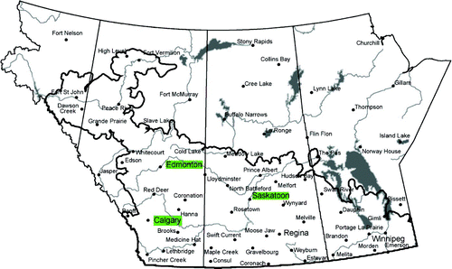
Three sites that were dramatically affected by the drought on the Prairies (Calgary, Edmonton and Saskatoon) were selected for the study (). These were chosen based on two criteria: 1) the sites had a long-term historical record of meteorological observations and 2) an Environment Canada radar site was in close proximity.
Fig. 1 Map of the Canadian Prairie provinces, with the extent of agricultural land outlined and study locations highlighted in green (adapted from Agriculture and Agri-Food Canada (Citation2009 by permission).
The paper is organized as follows. Section 2 details the various datasets used; Section 3 discusses the climatological features of precipitation; and Section 4 examines the classification of precipitation events, including virga. Section 5 summarizes key findings.
2 Data and analysis methods
To carry out the study, various sources of information were required. The following subsections describe the precipitation data, radar and sounding analyses, and the assessment of atmospheric conditions.
a Precipitation Data
Historical records of amount-corrected daily precipitation data were obtained from Environment Canada for three Prairie locations: Calgary (110 years), Edmonton (110 years) and Saskatoon (98 years). These precipitation data have been adjusted to account for factors contributing to data inaccuracies including gauge undercatch, evaporation and systematic biases due to a change in measurement technique (Mekis and Hogg, Citation1999). The precipitation data include trace amounts.
These corrected precipitation data were used to prepare climatologies against which precipitation accumulations during the drought were compared. Additionally, the precipitation data were used to establish distributions at daily, seasonal and annual time scales for three periods which were defined as long-term climatology (1895–2004 or 1906–2004 depending on location), drought (1999–2004) and sub-drought (2001–02).
b Radar and Sounding Analyses
Archived radar data were obtained from Environment Canada in order to examine precipitation features. As will be discussed in Section 4, the summers (June, July and August) of 2001 and 2002 were of particular interest and so the radar analysis focused on these periods. Data were acquired for three locations: Strathmore, near Calgary; Carvel, near Edmonton; and Radisson, near Saskatoon. These radars are part of the Canadian Radar Network which has 28 Doppler radars across Canada operated by the Meteorological Service of Canada. These Doppler radars scan 24 elevations in conventional reflectivity (0.3o to 24.7o) and four Doppler elevations (0.3o to 1.5o) every 10 minutes. The antennae have a 1o beam width, and have a 1 km (256 km range) and 0.5 km (113 km range) range resolution for conventional scans and Doppler scans, respectively. More information about the Canadian Doppler radar network can be found at Environment Canada (Citation2004).
The intent of incorporating radar data into the study was to gain insight into precipitation event details, such as condensate structure aloft, that may not have been apparent in the surface-based precipitation and meteorological records. For our purposes, virga was defined as radar reflectivity aloft, with indications of precipitation falling but not reaching ground level, presumably because of evaporation and/or sublimation. Precipitation events were classified on the radar profiles as either convective or stratiform by visually identifying the presence of a radar reflectivity aloft (bright band) and examining the time scale and vertical extent of the echoes. Convective events tend to be of shorter duration and have greater vertical depth than stratiform events, which appear more as steady, longer-lived periods of high reflectivity with relatively shallow vertical extent. Stratiform events are also often characterized by the presence of a bright band. Given that there is no clear-cut method of classifying stratiform or convective precipitation structures (Steiner et al., Citation1995), the relatively few time-height radar profiles lent themselves readily to a visual inspection.
c Atmospheric Conditions
During events of interest, information obtained from the radar reflectivities was augmented with meteorological data to understand the state of the atmosphere better. As described below, a wide variety of surface-based observations and model products were used.
Meteorological Terminal Air Report (METAR) hourly station observations of surface measured variables were used. These include temperature, dewpoint, wind speed and direction, current weather observation, cloud cover and ceiling height, defined as the height of the lowest layer of cloud that is broken or overcast (AMS, Citation2000). Virga observations are also recorded by an observer. However, because these are not automated observations, it should be noted that there is some subjectivity in the records, and the ability to make visual observations of virga during nighttime hours is questionable.
Products were also acquired from the National Centers for Environmental Prediction (NCEP) North American Regional Reanalysis (NARR) which is based on the Eta model, with a 32 km spatial resolution, 45 vertical layers and 3 h temporal resolution (see Kalnay et al., Citation1996; Mesinger et al., Citation2006). These were used to determine the mean atmospheric conditions during virga events and during precipitation (convective and stratiform) including ceiling height, freezing level and the boundary layer height, temperature and relative humidity.
Using the radar data to classify precipitation initially into convective, stratiform or virga types allowed a subsequent analysis of the attendant atmospheric conditions for each category.
3 Precipitation characterization
In this section, the precipitation research results are presented systematically. First, the precipitation will be characterized at various time scales. This will be followed by an analysis focused on the summer months of two particularly dry years, 2001 and 2002, which has been termed the “sub-drought” for this study.
a Annual Precipitation
Long-term climatologies and standard deviations were established for each location using the amount-corrected precipitation data (). The greatest average annual total precipitation was 498 mm at Edmonton, followed by 472 mm at Calgary and 418 mm at Saskatoon. Annual precipitation at these stations is quite variable from year to year as indicated by the high standard deviation values. Calgary has the highest annual variation (109 mm) which represents almost one-quarter of the average annual total precipitation.
Table 1. The six-year (1999–2004) annual average precipitation amounts compared to those from climatology (1896–2004 for Calgary and Edmonton, 1906–2004 for Saskatoon) at each study site. Annual standard deviations are shown in brackets.
At all three study locations, the six-year annual average from 1999 to 2004 did not indicate a large deficit in precipitation compared to the long-term climatological amount. As shown in , based on the long-term climatology, Calgary received 98% of the precipitation that would normally be expected, whereas Edmonton and Saskatoon received 95% and 90%, respectively. Given that these areas received total precipitation close to climatology (based on the annual total amounts for the six-year period), the precipitation variations at smaller time scales were further investigated to understand why the area experienced some of the debilitating effects of extreme drought.
Individual annual precipitation totals for the years 1999–2004 revealed year–to-year variations at each study site. Based on this analysis, Calgary experienced two consecutive precipitation-deficient years: 2001–2002, Edmonton three years: 2000–2002 and Saskatoon four years: 2000–2003 (). The most dramatic precipitation shortfall (of 214 mm, or −51%, anomaly from climatology) was observed in Saskatoon in 2001. Based on the annual total precipitation amounts, this was the driest year on record since 1906, exceeding the negative precipitation anomaly of the next driest year by nearly 30% (Phillips, Citation2002). The greatest annual precipitation positive anomaly (compared to climatology) occurred in 2004 (+91 mm) and was notably lower in magnitude than the greatest shortfall (−199 mm) both of which occurred during the 1999–2004 drought.
Table 2. Annual precipitation anomalies (mm) with respect to the annual climatology. The fraction of the precipitation anomaly relative to one standard deviation is shown in brackets. The sequential dry years are in bold font.
This annual analysis facilitates a broad-scale assessment of the drought and it was seen that meteorological drought conditions (i.e., lack of precipitation) were most widely felt in 2001 and 2002 with precipitation deficits recorded at all three locations.
b Seasonal Precipitation
When precipitation is classified by season, the finer temporal resolution allows important patterns to be revealed. Different features in seasonal precipitation are evident at each location, highlighting the variability and evolution of this recent drought.
All three sites exhibited a sustained period of less than normal seasonal precipitation (). At Calgary, there was a period of seasonal precipitation deficits. This dry period began in autumn 1999 with a relatively large negative precipitation anomaly (−60%). Following this particularly dry autumn, of the 12 seasons from autumn 1999 to summer 2002, negative precipitation anomalies occurred during ten, and amounts that were (slightly) above normal occurred in only two. Again, the most notable feature on this plot is the continuity of these small deficits for eight consecutive seasons without respite: autumn 2000 to summer 2002 all showed negative anomalies in precipitation. These deficits were not record-breaking, but they were consistent and contributed to a cumulative lack of moisture, sustaining drought conditions over many months.
Fig. 2 Seasonal precipitation anomalies for winter 1999 to autumn 2004 calculated as a fraction (%) that would be expected climatologically for a) Calgary, b) Edmonton and c) Saskatoon.
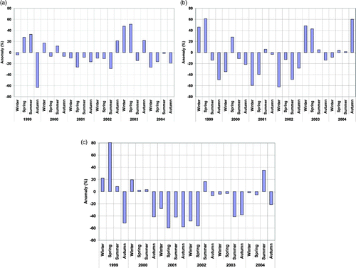
At Edmonton, there was a similar dry period lasting from summer 1999 to the end of autumn 2002. During these 14 consecutive seasons, modestly above average precipitation occurred in only two seasons: spring 2000 and summer 2001. Again, the consistency of the precipitation deficits is noteworthy when considering the cumulative impact of (almost) continuously drier than normal conditions over a multi-year period. In 2001, the slightly above average summer season precipitation followed by an autumn season with just slightly below average precipitation helped to alleviate the severity of drought conditions at Edmonton. In the following year, 2002, a precipitation deficit was exhibited in all seasons, and the annual precipitation fell short of climatology by 199 mm.
Of the three locations, Saskatoon showed the most consistent deficits in precipitation. The seven consecutive seasons from autumn 2000 (−41% anomaly) to spring 2002 all had well below-normal precipitation, with seasonal anomalies ranging from −28% to −60%. These considerable negative anomalies were embedded in an extended period of (less severe) dry conditions lasting from autumn 2000 to spring 2004. During this time, above average precipitation occurred in only one season (summer 2002) out of 15 received, with a relatively modest positive anomaly of +16%.
c Daily Precipitation
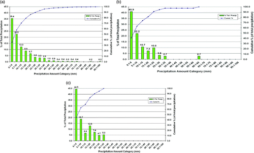
Using daily precipitation totals (for all months), precipitation amount distributions were calculated for each location (). These plots allowed several critical observations to be made. First, the results were quite similar at each location. Second, smaller accumulation events (defined in this study as ≤10 mm daily total accumulation) always constitute the majority (i.e., >50%) of precipitation falling at all three locations. The cut-off of 10 mm was used because, historically at least, precipitation less than 8–10 mm in semi-arid regions has been considered ecologically unimportant (Coupland, Citation1950; Paulson and Ares, 1962; Reynolds and Martin, Citation1968). Furthermore, the smallest amount bin (daily accumulations of 0.1 mm to 5 mm) always accounted for the greatest proportion of the total precipitation. Third, the amount distributions for the sub-drought years of 2001–02 consistently illustrated a higher increase in the relative proportion of smaller precipitation events compared to climatology. Thus, smaller precipitation events continued to be an important source of moisture (or were of even more importance) during these drought years. Fourth, the 1999–2004 drought and especially the 2001–02 sub-drought were characterized by a relative absence of large precipitation events. No event above 45 mm occurred at any location during the sub-drought, and from a precipitation analysis perspective, it was the absence of such large events that characterized the drought. In addition, a comparison between the various distributions shown in indicate that all of the distributions were significantly different based on the Kolmogorov-Smirnoff test at the 5% level. This indicates that the distributions came from different sample populations.
Fig. 3 Precipitation distribution at Calgary for a) climatology, b) drought (1999–2004) and c) sub-drought (2001–02). The vertical bars show the relative percentage contribution (left axis) and the blue line shows the cumulative contribution (right axis) of each amount bin to the total (annual) precipitation.

Fig. 4 Precipitation distribution at Edmonton for a) climatology, b) drought (1999–2004) and c) sub-drought (2001–02). The vertical bars show the relative percentage contribution (left axis) and the blue line shows the cumulative contribution (right axis) of each amount bin to the total (annual) precipitation.
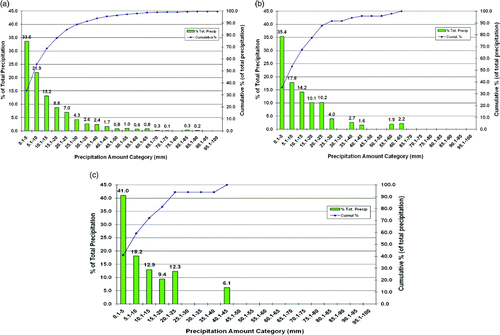
Fig. 5 Precipitation distribution at Saskatoon for a) climatology, b) drought (1999–2004) and c) sub-drought (2001–02). The vertical bars show the relative percentage contribution (left axis) and the blue line shows the cumulative contribution (right axis) of each amount bin to the total (annual) precipitation.
The relative contributions of smaller events in the summer months (as opposed to the entire year) were assessed separately since the annual results may be skewed toward smaller precipitation amounts by the relatively small (total water equivalent) winter snow events (). Precipitation amount distributions were recalculated using the same daily accumulation bins as before but including only data from the summer months of June, July and August. The results indicate that during these months, smaller events always contributed significantly to the total summer precipitation amount. The climatology indicates that smaller precipitation events contributed 39% of total summer precipitation at Calgary, 40% at Edmonton and 44% at Saskatoon. Consequently, the contribution of smaller events to the total accumulation in summer was less than their contribution on a climatological annual basis (with reductions ranging from 13 to 16% less at the three study sites), but smaller precipitation events were still an important source of moisture. For the cases of summer precipitation that were well below climatology (anomaly of −29% or greater), the smaller precipitation events became more prominent as a moisture source and accounted for more than 50% of the total precipitation amount. Both cases of above-normal summer precipitation showed a decreased proportion of precipitation coming from smaller events.
Table 3. The fraction of total precipitation from smaller events (≤10 mm daily accumulation) for both annual and summer (June, July and August) precipitation. The analysis is further divided into four time scales. The driest summers (precipitation anomalies ≥-29%) are shown in bold.
d Days with Precipitation
Climatologically during the summer, approximately 50% of the 92 days in June, July and August receive measurable precipitation at the study sites. Edmonton has the highest proportion of summer precipitation days (55%), followed by Calgary and Saskatoon with 47% and 45%, respectively (). The greater number of precipitation days in Edmonton is likely a consequence of Edmonton's proximity to the mean summer storm track (Nkemdirim and Weber, Citation1999).
Table 4. Summer days with precipitation (any amount) as a fraction of the 92 total summer season days, shown with the seasonal precipitation amount anomaly (%).
In comparison, Montréal, with a relatively humid climate, has, on average, only 41% of summer days with precipitation. Furthermore, summer precipitation accounts for only 27% of the annual precipitation total at Montréal. This highlights the importance of summer precipitation to the total accumulation over the Prairies, where summer season events make up the majority (≥50%) of annual precipitation, on average (Longley, Citation1972; Dey, Citation1982).
As shown in , it is not necessarily the number of precipitation days that dictates precipitation amount. For example, at Saskatoon, the summer of 2002 had a positive precipitation anomaly, but the proportion of days with precipitation remained equivalent to the climatological value. However, for the summers with negative precipitation anomalies, at all locations there were either fewer or more days with precipitation. The climatological values for summer days with precipitation found in this study correspond well to those found by Roberts et al. (2006). In that analysis, at ten Canadian Prairie locations under drought conditions from 1953–2001, on average, precipitation occurred on 44% of warm season days.
Overall, the analysis indicates that for this particular drought, the dry conditions during summer were not necessarily due to a lack of days with precipitation, but were sometimes due to a reduced amount of precipitation falling, on average, per day which resulted in below-normal accumulations of precipitation.
4 Summer 2001 and 2002 precipitation events
The following analyses will focus on the two particularly dry summers — 2001 and 2002. It is critical to determine the physical features of the precipitation, and non-precipitation, events that occurred during these periods.
a Event Classification
The first step of the analysis was to classify events into one of three categories: convective, stratiform or virga. It should be noted that virga and precipitation are not always mutually exclusive on a given day, so these (mixed) events were categorized on the basis of the precipitation (such that virga days were exclusively virga with no precipitation reported). The approach used to carry out this classification was based on archived radar data described in Section 2b.
b Convective and Stratiform Events
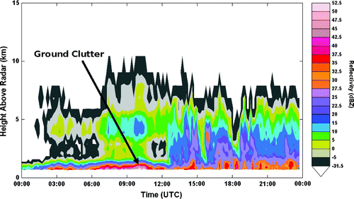
Illustrative cases of typical convective and stratiform events are shown in the time-height vertical profiles of and . The convective event in lasted approximately 2 h (10:00 – 11:00 utc); it extended vertically to approximately10 km, and it produced 8 mm of rainfall. The stratiform event in lasted for more than 9 h on this day; it only extended to approximately 6 km vertically, with the highest reflectivities much closer to the surface, and it produced 15 mm of rainfall over a 24 h period.
Fig. 6 An example of a typical convective precipitation case as identified by the time-height vertical profile of radar reflectivity. The vertical axis is height and the horizontal axis is time. This event occurred on 6 August 2002 at Saskatoon.
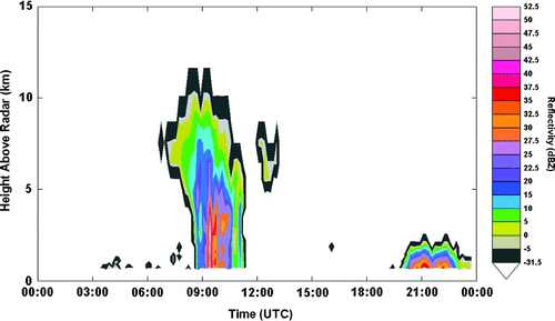
Fig. 7 An example of a typical stratiform precipitation case as identified by the time-height vertical profile of radar reflectivity. The vertical axis is height and the horizontal axis is time. This event occurred on 2 August 2002 at Edmonton.
By classifying precipitation into convective or stratiform, it was possible to assess the relative contributions of different types of events to the total monthly and seasonal (summer) precipitation amounts and to determine whether any patterns could be detected in these ratios in relation to the precipitation anomalies. This classification was applied to precipitation events occurring during the summer months of 2001 and 2002 at each study location (, and ). These tables also include, for each study location, monthly precipitation totals and the associated anomaly to facilitate identification of relatively wet and dry months and/or summers.
Table 5. Proportion of convective and stratiform precipitation at Calgary for the summers of 2001 and 2002. Monthly precipitation amounts and departures from average are also shown.
Table 6. Proportion of convective and stratiform precipitation at Edmonton for the summers of 2001 and 2002. Monthly precipitation amounts and departures from average are also shown.
Table 7. Proportion of convective and stratiform precipitation at Saskatoon for the summers of 2001 and 2002. Monthly precipitation amounts and departures from average are also shown.
For some days, it was not possible to attribute precipitation exclusively to either the convective or stratiform categories. These events were sorted into an “unclassified” category. The unclassified amount varied, but was usually a small portion (≤6%) of the monthly precipitation total. The only exception was June 2001 at Calgary when an ongoing combination of convective and stratiform precipitation accounted for 29% of the monthly total.
There was no clear relation at any location between the proportion of precipitation from convective or stratiform events and monthly precipitation anomalies. However, there were at times high correlations between the total precipitation and the total precipitation from either stratiform or convective events. All the correlations, except one, was greater than 0.68 and as high as 0.91. This means that, in general, the monthly accumulations are either largely convective or stratiform in nature. The one exception was the total precipitation and convective precipitation at Calgary (0.15) and this was due to the lack of convective precipitation during June 2002. Calgary was the only location with a monthly accumulation which came almost exclusively (95%) from stratiform precipitation. All three locations experienced months when the total precipitation accumulation was essentially due only to convective systems (≥98%). There were no instances of a month at any location with a positive precipitation anomaly with an overwhelming dominance (i.e., 80% or greater) of either convective or stratiform precipitation.
c Virga
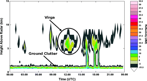
Virga also occurred during the drought. As discussed in Section 2c, sightings of virga are found in the observations and/or remarks in weather reports from surface stations. Radar data can also be used to examine the occurrence of virga. The time-height vertical profile shown in indicates an example of a profile typical of virga (i.e., radar reflectivities aloft but none near the surface). The radar reflectivities at 10:00–13:00 utc, located at 4–8 km above the surface were substantiated by surface-based observations of virga. Cases of virga identified by radar generally confirmed the surface-based observations during daylight hours at Edmonton and Calgary but not at Saskatoon where, for reasons unknown, surface-based observations of virga were noted much less frequently.
Fig. 8 An example of virga, identified using a time-height vertical profile of radar reflectivity. The vertical axis is height and the horizontal axis is time. This case occurred 2 June 2001 at Edmonton. The elevated values of radar reflectivity at the lowest levels are the echoes from the surface (ground clutter).
d Hours of Precipitation and Virga
Hours with precipitation and virga observations recorded in the surface station data are shown with the monthly number of heavy precipitation events (≥ 10 mm daily accumulation) for all three study sites in . Precipitation hours do not distinguish between stratiform or convective events. An average monthly precipitation rate was calculated by dividing the monthly precipitation amount by the number of hours with observed precipitation.
Table 8. Summer monthly hours with precipitation and virga based on surface observations at Calgary, Edmonton and Saskatoon, respectively, for 2001 and 2002. The average monthly precipitation rate (P.R.) and number of heavy precipitation events (≥10 mm d−1) at each location are also shown.
The hours with observations of precipitation and virga varied greatly during the summers of 2001 and 2002. At Edmonton, for example, the hours with precipitation varied from 19 to 97. Although there is considerable uncertainty in the exact values, the overall occurrence of virga was also substantial, with surface-based estimates of virga up to 58 h during July 2002 in Edmonton. In some months, virga was reported more often than precipitation even though there were few virga reports at night because of the technique used by observers. In contrast, observations of virga were always far below those of precipitation at Saskatoon; this may be due, at least in part, to unknown observational issues leading to under-reporting.
At Calgary, a comparison between the average precipitation rates () and the monthly precipitation anomalies () resulted in a correlation coefficient of 0.51, indicating a weak relationship. In fact, the highest precipitation rate, recorded in July 2001, was associated with a monthly precipitation anomaly of −10% (), whereas the next highest precipitation rate in June 2001 was associated with a monthly precipitation anomaly of +37%. This indicates that a month during which the event(s) had a high precipitation rate did not necessarily lead to a month with a positive precipitation anomaly. Essentially, this means there was a lack of smaller precipitation events and/or periods during these months. Also, the number of hours of precipitation in 2002 was greater than in 2001, even though the precipitation received in summer 2001 (207 mm) was closer to the climatological amount than in the summer of 2002 (162 mm). The summer of 2002, with a lower overall hourly precipitation rate, had a higher percentage of precipitation from smaller and stratiform events. This is consistent with the observation that the summer of 2002 only had five heavy precipitation events, compared to 10 in summer 2001. This is also linked with far fewer virga reports in 2002 than in 2001.
At Edmonton, there was a slightly higher correlation on a monthly basis between precipitation rates and total precipitation accumulation (0.47) compared to Calgary (0.35). However, there was considerably less consistency when comparing monthly precipitation rates and other data. For instance, July and August 2001 had equivalent rates (1.6 mm h−1) but very different precipitation anomalies (+67% and −57%, respectively, from ). In contrast to Calgary, there were significantly fewer precipitation hours in the summer of 2002 than in 2001 but considerably more virga hours. This leads to the slightly more intuitive result that months with a higher number of virga observations may have less precipitation accumulation due to a decreased efficiency of precipitation reaching ground level.
Saskatoon had the highest correlation between monthly precipitation rates and total precipitation accumulation (0.52). However, significantly fewer hours of precipitation occurred in the record breaking dry year of 2001 than in the summer of 2002. Most of this deficit however, is attributable to August 2001, which had a total of only seven hours of precipitation, leading to a precipitation accumulation anomaly of −85%.
One factor that holds true for all three stations is that summers with a higher number of heavy events had higher precipitation accumulations. While this result may seem obvious, it is not trivial in the sense that it may be possible to have high accumulations from a large number of smaller events.
e Virga and Atmospheric Conditions
At each study location, and for each event type (convective, stratiform or virga), the attendant atmospheric conditions were investigated in order to compare characteristics between event types. Using data from the NARR corresponding to the dates of the precipitation events identified with the radar data, the mean values of ceiling height, freezing level (height of 0°C layer above ground), as well as the boundary layer height, relative humidity and temperature were computed and are shown in .
Table 9. Mean values of various measurable atmospheric conditions compiled from NARR data for days of virga, convective and stratiform events at Calgary, Edmonton and Saskatoon, respectively, for the summer months of 2001 and 2002.
Some general observations can be made about this information. Virga events were consistently associated with the highest mean ceiling heights, and this mean level was above that of the freezing level. Therefore, in the mean, clouds that produced virga were at sub-freezing temperatures. Given similar atmospheric conditions, for the same precipitation rate, snowflakes (with relatively slow fall rates) will sublimate more rapidly than faster-falling raindrops will evaporate (Clough and Franks, Citation1991). Thus, since the sublimation occurs at a faster rate than does evaporation, snow falling below a cloud base at <0oC (as opposed to rain when the cloud base >0oC) would more readily dissipate upon its descent through a sub-saturated atmosphere. This, in combination with the typical conditions associated with virga events (extended fall distances resulting from the elevated ceiling heights and low values of ambient relative humidity) is conducive to the production of virga, as opposed to precipitation reaching the ground.
Convective events were associated with the highest freezing levels and with ceiling heights considerably lower than those seen for virga events. This result is consistent with the fact that convection often occurs in warm humid conditions. The mean ceiling heights in convective events were well below the mean freezing level, so, on average, cloud bases were above freezing. Thus, for precipitation falling from the cloud base, it can be assumed that evaporative processes dominated those of sublimation.
The lowest mean ceiling heights were associated with stratiform events. These events were also associated with the lowest average boundary layer heights, highest boundary layer relative humidities and lowest temperatures. The mean ceiling heights were low enough that both sublimation and evaporation were of much less importance than during convective events.
5 Concluding remarks
The Canadian Prairie drought of 1999–2004 had a catastrophic impact on many sectors of regional socio-economic activities. The drought, particularly in 2001 and 2002, brought conditions unseen for at least one hundred years in some regions (Wheaton, 2001). This study characterized some of the small-scale features of precipitation at the surface and aloft during this recent drought. Specifically, precipitation frequency and characteristics at three western Prairie locations (Edmonton, Calgary and Saskatoon) were investigated.
When considering the entire six-year drought period from 1999–2004, the total amount of precipitation was close to normal. Each location received at least 90% of normal precipitation accumulation, with Calgary receiving 98% of normal. The drought was most severely felt over 14 consecutive seasons from autumn 1999 to winter 2003, during which time all three sites experienced persistently dry conditions. The greatest shortfalls were recorded in Saskatoon, where the precipitation was below average for 18 consecutive months, from January 2001 to June 2002.
Climatologically, smaller precipitation events (≤10 mm daily accumulation) account for more than 50% of the annual accumulation at all three locations. Even during the warm season, when one might expect a prevalence of heavier convective events, the smaller events still account for approximately 40% of the average total seasonal accumulation. The contribution of these smaller events remained relatively consistent during the 1999–2004 drought, in contrast to heavy events, which decreased throughout the drought. Periods deficient in precipitation during the drought therefore tended to be defined by a dearth of heavy events. It should be noted that some of the periods discussed in this article also broke all-time precipitation deficit records.
Precipitation events during the summers of 2001 and 2002 were classified as either convective or stratiform. There was no consistent preference for either type of precipitation process; however, there were often correlations between stratiform or convective precipitation and monthly accumulations, at times as high as 0.91. There are several implications that can be drawn from this finding. One is that runoff at the surface would vary dramatically even for the same amount of precipitation, and this would need to be accounted for within hydrological models. Another is that techniques to infer precipitation from space must account for the wide variation in the character of precipitating systems.
It is important to note that instances of precipitation commonly occurred, even during the drought's warm season. In contrast, a common technique for assessing drought occurrence is to determine the number of consecutive dry days. Such an approach may well apply to other droughts but not the 1999–2004 Canadian Prairie one. Drought, in general, must exhibit a range of conditions in terms of precipitation occurrence, and this has to be considered when using statistical approaches to infer its occurrence.
Instances of virga were common and were linked with, in general, the lowest boundary layer relative humidity, highest cloud base heights and coldest cloud base temperature. The latter is especially important because virga was the only precipitation classification in which the mean cloud base height was higher than the freezing level (i.e., the temperature was below freezing at the cloud base). Snow falling from such clouds is more likely to sublimate completely than an equivalent amount of rain evaporating from warmer clouds. The generation of cold (not just high) cloud bases then acts as a means of prolonging non-precipitation and/or virga periods.
In conclusion, for at least three western Canadian Prairie locations, the recent drought was not devoid of rain events, even in its most severe phase, but was driven by a dearth of heavy precipitation events (daily accumulations ≥10 mm). The precipitation that did occur mainly came in low accumulation stratiform and/or convective events and significant precipitation aloft did not reach the surface.
Acknowledgements
The authors would like to thank the Canadian Foundation for Climate and Atmospheric Sciences, Environment Canada, the Natural Sciences and Engineering Research Council of Canada and the Institute for Catastrophic Loss Reduction for their support. The authors would also like to thank Dave Patrick of Environment Canada for providing radar data used in this study.
Related Research Data
References
- Agriculture and Agri-Food Canada . 2009 . Map Archive. (Government of Canada). Retrieved from http://www4.agr.gc.ca/DW-GS/historical-historiques.jspx?lang=eng&jsEnabled=true
- Akinremi , O. O. and Mcginn , S. M. 1999 . Precipitation trends on the Canadian Prairies . J. Clim. , 12 : 2996 – 3003 .
- AMS (American Meteorological Society) . 2000 . Glossary of Meteorology , 2 Retrieved from http://amsglossary.allenpress.com/glossary
- Bonsal , B. R. , Zhang , X. and Hogg , W. D. 1999 . Canadian Prairie growing season precipitation variability and associated atmospheric circulation . Clim. Res. , 11 : 191 – 208 .
- Bonsal , B. and Wheaton , E. 2005 . Atmospheric circulation comparisons between the 2001 and 2002 and the 1961 and 1988 Canadian Prairie droughts . Atmophere-Ocean , 43 : 163 – 172 .
- Clough , S. A. and Franks , R. A. 1991 . The evaporation of frontal and other stratiform precipitation . Q. J. R. Meteorol. Soc. , 117 : 1057 – 1080 .
- Coupland , R. T. 1950 . Ecology of mixed prairie in Canada . Ecol. Monogr. , 20 : 271 – 315 .
- Dey , B. 1982 . Nature and possible causes of droughts on the Canadian Prairies – case studies . J. Climatol. , 2 : 233 – 249 .
- Dominguez , F. and Kumar , P. 2005 . Dominant modes of moisture flux anomalies over North America . J. Hydrometeorol. , 6 : 194 – 209 .
- Environment Canada. 2004. The national radar program. Retrieved from http://www.msc-smc.ec.gc.ca/projects/nrp/
- Fraser , A. B. and Bohren , C. F. 1992 . Is virga rain that evaporates before reaching the ground? . Mon. Weather Rev. , 116 : 1565 – 1571 .
- Greene , H. , Leighton , H. and Stewart , R. E. 2011 . Drought and associated cloud fields over the Canadian Prairies . Atmosphere-Ocean , doi: 10.1080/07055900.2011.559771
- Kalnay , E. , Kanamitsu , M. , Kistler , R. , Collins , W. , Deaven , D. , Gandin , L. , Iredell , M. , Saha , S. , White , G. , Woollen , J. , Zhu , Y. , Chelliah , M. , Ebisuzaki , W. , Higgins , W. , Janowiak , J. , Mo , K. C. , Ropelewski , C. , Wang , J. , Leetmaa , A. , Reynolds , R. , Jenne , R. and Joseph , D. 1996 . The NCEP/NCAR 40-year reanalysis project . Bull. Am. Meteorol. Soc. , 77 : 437 – 470 .
- Knox , J. L. and Lawford , R. G. 1990 . The relationship between Canadian Prairie dry and wet months and circulation anomalies in the mid-troposphere . Atmosphere-Ocean , 28 : 189 – 215 .
- Liu , J. , Stewart , R. E. and Szeto , K. K. 2004 . Moisture transport and other hydrometeorological features with the severe 2000/01 drought over western and central Canadian Prairies . J. Clim. , 17 : 305 – 318 .
- Longley , R. W. 1972 . The Climate of the Prairie Provinces (Climatological Studies No. 13) , Ottawa, ON : Atmospheric Environment Service, Department of the Environment .
- Maybank , J. , Bonsal , B. , Jones , K. , Lawford , R. , O'brien , E. G. , Ripley , E. A. and Wheaton , E. 1995 . Drought as a natural disaster . Atmosphere-Ocean , 33 : 195 – 222 .
- Mekis , E. and Hogg , W. D. 1999 . Rehabilitation and analysis of Canadian daily precipitation time series . Atmosphere-Ocean , 37 : 53 – 85 .
- Mesinger , F. , Dimego , G. , Kalnay , E. , Mitchell , K. , Shafran , P. C. , Ebisuzaki , W. , Jović , D. , Woollen , J. , Rogers , E. , Berbery , E. H. , Ek , M. B. , Fan , Y. , Grumbine , R. , Higgins , W. , Li , H. , Lin , Y. , Manikin , G. , Parrish , D. and Shi , W. 2006 . North American regional reanalysis . Bull. Am. Meteorol. Soc. , 87 : 343 – 360 .
- Nkemdirim , L. and Weber , L. 1999 . Comparison between the droughts of the 1930s and the 1980s in the southern Prairies of Canada . J. Clim. , 12 : 2434 – 2450 .
- Paulsen , H. A. Jr. and Ares , F. N. 1962 . Grazing values and management of black grama and tobosa grasslands and associated shrub ranges of the Southwest (Technical Bull. No. 1270). USDA Forest Service
- Phillips , D. 1990 . The Climates of Canada , Ottawa, ON : Environment Canada .
- Phillips , D. 2002 . Top ten Canadian weather stories of 2001 . CMOS Bull. , 30 : 19 – 23 .
- Quiring , S. M. and Papakyriakou , T. N. 2005 . Characterizing the spatial and temporal variability of June–July moisture conditions in the Canadian Prairies . Int. J. Climatol. , 25 : 117 – 138 .
- Reynolds , H. G. and Martin , S. C. 1968 . Managing grass-shrub cattle ranges in the Southwest (USDA Agricultural handbook, No. 162). U.S. Forest Service
- Roberts , E. , Stewart , R. E. and Lin , C. A. 2006 . A study of drought characteristics over the Canadian Prairies . Atmosphere-Ocean , 44 : 331 – 345 .
- Shabbar , A. and Skinner , W. 2004 . Summer drought patterns in Canada and the relationship to global sea surface temperature . J. Clim. , 17 : 2866 – 2880 .
- Steiner , M. , Houze , R. A. and Yuter , S. E. 1995 . Climatological characterization of three-dimensional storm structure from operational radar and rain gauge data . J. Appl. Meteorol. , 34 : 1978 – 2007 .
- Stewart , R. E. , Pomeroy , J. and Lawford , R. 2011 . The Drought Research Initiative: A comprehensive examination of drought over the Canadian Prairies . Atmosphere-Ocean , 49 doi: 10.1080/07055900.2011.622574
- Wallace , J. M. and Gutzler , D. S. 1981 . Teleconnections in the geopotential height field during the northern hemisphere winter . Mon. Weather Rev. , 109 : 784 – 812 .
- Weber , L. and Nkemdirim , L. 1998 . Palmer's drought indices revisited . Geogr. Ann. , 80A : 153 – 172 .
- Wheaton , E. 2011 . “ What effects do droughts have in Canada? Highlights of the repercussions of a major multi-year drought ” . The 1999-2005 Canadian Prairies Drought: Science, Impacts, and Lessons (Saskatchewan Research Council report no. 11602-3A10). Winnipeg, MB: Drought Research Initiative