Abstract
The hydrography, wind, Argos and Argo measurements in the areas surrounding Luzon Strait were collected. Based on the hydrographic data obtained during September 1994, the improved Princeton Ocean Model using a generalized topography-following coordinate system together with a modified inverse method was applied to study the circulation in September. Observations and the diagnostic simulation produce a consistent circulation pattern, and the main dynamical features can be summarized as follows. (1) The Kuroshio has two branches with the main Kuroshio existing above 800 m depth and the western part existing above 400 m depth. The western branch of the Kuroshio leaves the main current near 20.5°N, then flows northwestward through Luzon Strait and finally flows out of the northern boundary southwest of Taiwan, consistent with the trajectory of Argos drifters. (2) The non-linear term is important and cannot be neglected in the momentum equations in the northern part of Luzon Strait under the baroclinicity field. Using non-linear dynamics, the westward intrusion of the Kuroshio into the northern part of Luzon Strait is more curved than when using linear dynamics. However, the non-linear term is smaller and so negligible around Luzon Strait under the homogeneous density field. (3) In the area from 117°E to 119°E and from 20.2°N to 21.7°N, an anticyclonic eddy appears east of Dongsha Islands. (4) At depths above 400 m, the circulation is mainly dominated by the basin-scale cyclonic gyre. (5) In the computational domain west of 121°E, the circulation below 800 m is mainly dominated by the basin-scale anticyclonic gyre. (6) The South China Sea water flows eastward across Luzon Strait in the middle layers, then turns cyclonically, finally flowing northward into the region east of Taiwan Island, which is qualitatively in agreement with the trajectories of Argo floats at about 1000 m depth in the area east of 121°E.
RÉSUMÉ [Traduit par la rédaction] Nous avons rassemblé l'hydrographie, le vent, les Argo et les mesures Argo dans les régions avoisinant le détroit de Luçon. Sur la base des données hydrographiques relevées durant le mois de septembre 1994, nous avons appliqué le modèle océanique amélioré de Princeton utilisant un système de coordonnées « suivant le terrain » généralisé de pair avec une méthode inverse modifiée pour étudier la circulation en septembre. Les observations et la simulation diagnostique produisent une configuration de circulation cohérente dont on peut résumer comme suit les principales caractéristiques dynamiques. (1) Le Kuroshio possède deux branches : le Kuroshio principal existant au-dessus d'une profondeur de 800 m et la partie ouest existant au-dessus d'une profondeur de 400 m. La branche ouest du Kuroshio quitte le courant principal aux environs de 20,5°N et se dirige vers le nord-ouest à travers le détroit de Luçon pour finalement franchir la limite nord du détroit au sud-ouest de Taïwan, ce qui correspond à la trajectoire des bouées dérivantes Argos. (2) Le terme non linéaire dans les équations est important et ne peut pas être considéré négligeable de quantité de mouvement dans la partie nord du détroit de Luçon dans le champ de baroclinité. Lorsqu'on utilise la dynamique non linéaire, l'intrusion vers l'ouest du Kuroshio dans la partie nord du détroit de Luçon est plus incurvée que lorsqu'on utilise la dynamique linéaire. Cependant, le terme non linéaire est plus petit et donc négligeable autour du détroit de Luçon dans le champ de densité homogène. (3) Dans la région allant de 117°E à 119°E et de 20,2°N à 21,7°N, un remous anticyclonique apparaît à l'est des îles Dongsha. (4) Aux profondeurs inférieures à 400 m, la circulation est principalement dominée par le gyre cyclonique à l’échelle du bassin. (5) Dans le domaine de calcul à l'ouest de 121°E, la circulation sous 800 m est principalement dominée par le gyre anticyclonique à l’échelle du bassin. (6) Les eaux de la mer de Chine méridionale s’écoulent vers l'est à travers le détroit de Luçon dans les couches intermédiaires, puis tournent de façon cyclonique pour finalement s’écouler vers le nord dans la région à l'est de l’île Taïwan, ce qui, qualitativement, s'accorde avec la trajectoire des flotteurs Argo à environ 1000 m de profondeur dans la région à l'est de 121°E.
1 Introduction
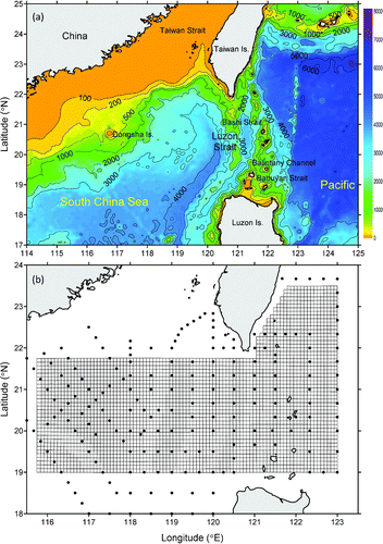
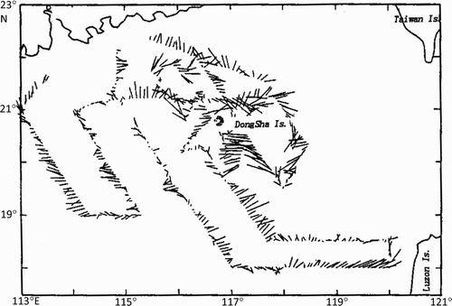
Luzon Strait, consisting of Bashi Strait, Balintany Channel and Babuyan Strait, is located between Taiwan Island and Luzon Island. It is the primary channel connecting the South China Sea (SCS) to the North Pacific Ocean and has complicated topography (a). There is a deep sill with the maximum water depth exceeding 2400 m in the central portion of Luzon Strait. The Strait is shallower (approximately 600 m) at both the northern and southern ends.
Fig. 1 (a) Bottom topography (m) around Luzon strait. (b) Observation stations of the survey from 31 August to 10 September 1994 as well as the horizontal grid of the model used.
The issue of the Kuroshio intrusion into the SCS through Luzon Strait has recently attracted much attention. The total volume transport through Luzon Strait (called the Luzon Strait Transport (LST) hereafter) is essentially westward (Qu, Citation2002; Qu et al., Citation2004). Various numerical models have been used to obtain the different values of annual mean LST, such as 2.4 Sv (1 Sv = 106 m3 s−1; Qu et al., Citation2004), 6.4 Sv (Fang et al., Citation2003), 4.1 Sv (Cai, Liu, Li, & Long, Citation2005) and so on. Qu (Citation2000) studied the intrusion of North Pacific waters into the SCS using the water mass distribution and historical hydrographic data and pointed out that from spring to fall the intruding waters are narrowly restricted to the continental slope south of China. Only in winter, when the northeast monsoon has fully developed, can the intruding waters spread into the southern SCS. Yuan, Han, and Hu (Citation2006) studied the path of the surface Kuroshio in the Luzon Strait area using remotely sensed data, and their results suggest that the dominant path of the surface Kuroshio intrusion in winter is directly from northeast of Luzon Island to southwest of Taiwan Island and then westward along the continental slope of the northern SCS. Thus, they concluded that the anticyclonic intrusion of the Kuroshio (i.e., loop current) is a transient phenomenon rather than a persistent circulation pattern in the Luzon Strait area. On the other hand, based on Acoustic Doppler Current Profiler (ADCP) data from 1997 to 1999 at three mooring stations, Liang, Yang, Tang, and Chung (Citation2008) noted that the Kuroshio consistently intruded into the SCS through central Luzon Strait, then most of the intruding component made a loop and flowed out of northern Luzon Strait, but a branch of the Kuroshio intruded into the SCS. Moreover, they found that the observed current velocity had large intraseasonal but small seasonal variations.
Recently, using satellite altimetry data from October 1992 to August 2004 and self-organizing maps, Liu, Weisberg, and Yuan (Citation2008) described the annual cycle of the SCS general circulation patterns as a change between two opposite basin-scale southwest–northeast oriented gyres embedded with eddies having low sea surface height anomalies (SSHAs) (cyclonic) in winter and high SSHAs (anticyclonic) in summer. The Kuroshio intrudes into the SCS through Luzon Strait when the SSHAs are low. Furthermore, Yuan et al. (Citation2008a) studied the circulation in the upper and middle layers of Luzon Strait during spring 2002. In their work, both the observed currents and calculated results of a diagnostic model show that part of the Kuroshio flows westward to intrude into the continental slope south of China with a net westward volume transport of 0.82 Sv in the upper layers from the sea surface to 400 m depth. However, in the middle layers between 500 and 1200 m, the SCS water which has a higher oxygen concentration than the water east of Luzon Strait flows eastward into the eastern side of Luzon Strait.
There are various viewpoints on the mechanisms responsible for the Kuroshio intrusion. For example, Metzger and Hurlbert (Citation1996) suggested that monsoon winds are an important mechanism controlling the seasonal variation of the Kuroshio intrusion by strengthening the sea level along the south China coast in winter and weakening it in summer. In the sense of linear dynamics, Qu (Citation2000) noted that the alongshore pressure gradient is the primary mechanism driving the intrusion current along the continental slope south of China. Stommel and Arons (Citation1960) pointed out that the western boundary current always intrudes as it encounters a meridional gap as a result of the β effect. Yuan, Han, and Hu (Citation2007) suggested that the growth and decay of the anticyclonic intrusions of the Kuroshio are closely related to the passages and evolution of mesoscale eddies in the Luzon Strait area. Liang et al. (Citation2008) thought that the variation in zonal transport across Luzon Strait was caused by variation in the sea surface height (SSH) west of northern Luzon Island caused by wind stress curl. Yuan et al. (Citation2008a, Yuan, Liao, & Yang, Citation2008b) suggested that the joint effect of baroclinicity and relief is the most important dynamical mechanism, and the second important dynamical mechanism is a result of the interaction between the wind stress and relief. Using a single layer depth-averaged approach, Sheremet (Citation2001) considered an idealized problem of a western boundary current leaping across a gap in a ridge and found that 1) as the inertia (Reynolds number, Re) increases, the boundary current can leap across the gap and the pattern of the flow changes from a penetrating regime to a leaping regime; 2) hysteresis occurs over the range of Reynolds numbers ReL < Re < ReP; thus this behaviour is analogous to the well-known teapot effect. From these different viewpoints, it can be seen that the mechanisms of the Kuroshio intrusion remain unclear. For example, as with non-linear dynamics, it is necessary to study and compare the different dynamical mechanisms.
In this paper, we undertake two main tasks. 1) On the basis of the non-linear dynamics, the variation of the main Kuroshio and eddies near the Kuroshio are described in both horizontal and vertical directions, with an emphasis on the intruding branch of the Kuroshio into the SCS through Luzon Strait. 2) In order to discuss further the dynamical mechanism of the westward intrusion of the Kuroshio into Luzon Strait, the magnitudes of all the terms in the original momentum equations were estimated, then the standard case considering the non-linear effect is compared with the linear case (Yuan et al., Citation2008b). In Section 2, we describe the conductivity-temperature-depth (CTD) measurements, the associated Argos and Agro observations. The three-dimensional model with a generalized topography-following coordinate system used here is explained in Section 3, and Section 4 presents the diagnostic results of the circulation in the model domain. Section 5 contains one of the highlights of this paper, a discussion of the dynamical mechanism in the study area. A summary is provided in Section 6.
2 Observations
The hydrographic data in the northern SCS and Luzon Strait area were obtained from joint surveys conducted by the Chinese Cross-Straits scientists from 31 August to 10 September 1994. The distribution of observation stations is shown in b. Additionally, the associated Argos and Agro observations were collected and treated in order to provide a good understanding of the circulation around Luzon Strait in September.
a Water Temperature and Wind Fields
The distribution of temperature at the sea surface, 200 m and 500 m depths are presented in . As a reveals, at the sea surface in the areas west of Luzon Strait, the water temperature is relatively uniform, ranging from 28.6°C to 28.9°C. An area of warm water appears at 118.5°E, 21.0°N. By contrast, the temperature in the areas east of Luzon Strait varies significantly, ranging from 27.5°C to 29.2°C. A larger area of warm water exists at 121.0°E, 20.2°N in the middle of Luzon Strait with the temperature at the centre being higher than 29.2°C. Additionally, an area of warm water appears at 123.0°E, 21.5°N.
Fig. 2 Temperature distributions at (a) the surface, (b) 200 m and (c) 500 m depths obtained from 31 August to 10 September 1994.
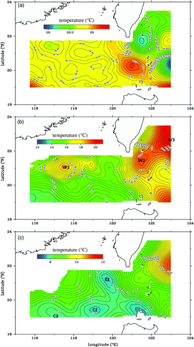
Comparing b with a, it can be seen that the temperature distribution at 200 m depth is very different from that at the sea surface. West of Luzon Strait, a larger area of warm water W1 occurs at 200 m depth, located at 117.5° E, 21.2°N. In the areas east of Luzon Strait, the warm water W2 is centred at 121.5°E, 21.5°N. The temperature contours at 500 m depth are shown in c. East of Luzon Strait, the warm water W3 still exists near the northeast corner (i.e., it exists from the sea surface to 500 m depth). West of Luzon Strait, there are three areas of cold water: C1 at 119.5°E, 21.5°N, C2 at 119.0°E, 19.5°N and C3 at 117.0°E, 19.0°N with centre temperatures lower than 8°C. Finally, the warm water area W1 is located at 118.0°E, 21.0°N with a centre temperature higher than 9°C. This warm core is evident from the sea surface to 500 m depth.
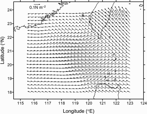
shows the distribution of wind stress derived from the National Centers for Environmental Prediction (NCEP) reanalysis data for the survey period (ESRL, Citation2008). The southeast wind dominated in the east, whereas the east wind dominated in the west of the model domain during September 1994.
Fig. 3 Wind stress derived from National Centers for Environmental Prediction (NCEP) reanalysis data for the survey period.
b Depth Distributions of Isopycnal Surfaces
The depth distribution of the isopycnal surface is a simple and effective indicator of the current pattern, although it cannot indicate the current in the shallower areas correctly, such as the areas near Luzon Island and Taiwan Island. On the basis of the hydrographic data obtained during the September cruise, the different isopycnal surfaces were calculated.
a and 4b depict the depth distributions of the 25.0 and 26.0 isopycnal surfaces, respectively and show the possible current patterns. These two isopycnal surfaces are located above approximately 400 m depth. It can be seen from and that 1) the anticyclonic eddy appearing east of Dongsha Islands is present with its centre located at 117.5°E, 21.1°N; 2) the main Kuroshio flows northward in the area east of Taiwan Island; and 3) part of the Kuroshio flows northeastward to intrude into the SCS through Luzon Strait.
Fig. 4 Depth (m) distributions for the (a) 25.0 and (b) 26.0 isopycnal surfaces in September 1994. The arrows indicate the current direction.
c Average Velocities from Argos Drifter Buoys
Argos surface drifter data are collected by the World Ocean Circulation Experiment (WOCE) Tropical Ocean Global Atmosphere (TOGA) Surface Velocity Program (SVP), using the Argos satellite system to locate the positions of freely-drifting surface buoys. Most surface buoys consist of a spherical surface float with a holey-sock drogue tethered at 15 m depth. Data used in this study were quality controlled and optimally interpolated to uniform six-hour interval trajectories (Hansen & Poulain, Citation1996) using the drifters' position data (Lumpkin & Pazos, Citation2010). The observed velocity data are derived from 910 drifters that were deployed in, or drifted to, the study area around Luzon Strait from 1 July 1989 to 30 June 2010. To obtain the ensemble means, the drifter velocity is binned on two spatial scales. In this study, a 0.5° bin size was selected and then the drifter velocity components in every bin were ensemble averaged for different months. Half-degree averaged drifter velocities for September are plotted in a.
Fig. 5 Half-degree averaged drifter velocities for September (a) between 1 July 1989 and 30 June 2010 and (b) from 1990 to 2005.
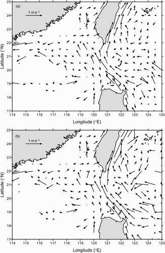
In a, it can be seen that there are two branches of the Kuroshio with a maximum velocity larger than 100 cm s−1 at the sea surface. The main Kuroshio makes an anticyclonic turn in the area southeast of Taiwan Island, then gradually turns back and finally flows northward into the region east of Taiwan Island. East of the main Kuroshio, there is an anticyclonic eddy with its centre located at about 123.0°E, 23.0°N. A western branch of the Kuroshio, which comes from the area near the east coast of Luzon Island, intrudes northwestward into Luzon Strait. Next, a northward current, coming from the area off the west coast of Luzon Island, flows northwestward west of the intruding branch of the Kuroshio. These two currents continue to intrude northwestward into the SCS and flow through the area southwest of Taiwan Island.
was obtained using only surface drifter data in September from 1990 to 2005 and is qualitatively in agreement with a. Moreover, comparing a with the averaged drifter velocities for other months (not shown), it can be seen that the differences among them are obvious. This illustrates that the seasonal variation of the circulation pattern is of major importance in Luzon Strait, as noted by Fang et al. (Citation2003, Citation2009).
d Trajectories of Argo Drifters
Argo is an international program providing near real-time assessment of the state of the world's oceans from an array of autonomous profiling floats. Since 2000 the international Argo program has launched more than 7000 Argo profilers that record temperature and salinity between the surface and 1000–2000 m depth every 10 days (http://www.argo.org.cn/english/argo_data/data.html). In total, approximately 85 Argo drifters were available for the present analysis domain for the period 26 September 2002 to 30 January 2010. The trajectories of Argo drifters appearing in September are shown in .
Fig. 6 Trajectories of Argo drifters appearing in September between 26 September 2002 and 30 January 2010. The blue dots denote their initial positions in September, and the numbers indicate their parking levels (m).
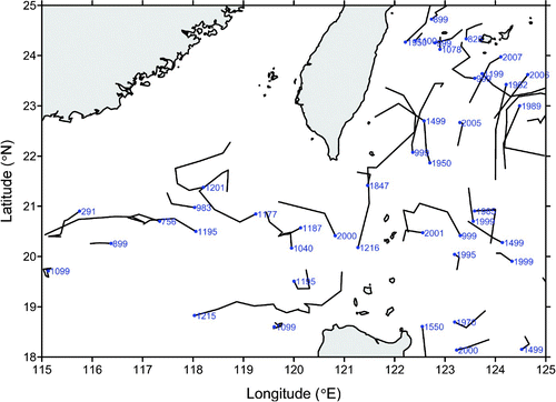
Three conclusions can be drawn from . 1) In the region west of 121°E, the circulation at a depth of about 1000 m is qualitatively dominated by the basin-scale anticyclonic gyre. 2) An Argo drifter at 1215 m moved eastward across Luzon Strait, indicating that the SCS water flows eastward across Luzon Strait in the middle layers, in agreement with the results of Qu (Citation2002) and Yuan et al. (Citation2008a, Citation2008b). 3) In the region east of 121°E, an Argo drifter at a depth of about 1000 m moved northward, then continued to flow northward into the region east of Taiwan Island.
3 Numerical model
First, the three-dimensional model equations used in the present study are briefly introduced. Then, the numerical grid and bathymetry, initialization, forcing and open boundary conditions are described. Finally, the numerical simulations are introduced.
a Governing Equations
The flow is assumed to be incompressible, and the Boussinesq approximation and hydrostatic assumption are used. The equations are written in a right-handed Cartesian coordinate system, (x, y, z, t), with the z-axis pointing vertically upwards and t denoting time. The velocity components in the x-, y- and z-directions are u, v and w, respectively; ρ is the fluid density; ρ 0 is the reference density; p is the pressure; g is the acceleration due to gravity; AM is the horizontal turbulent eddy viscosity; KM is the vertical turbulent eddy viscosity; f is the Coriolis parameter; T is temperature; and S is salinity. The continuity, momentum and state equations are:
with
b General Description of Numerical Methods
In order to take advantage of some of the useful properties of σ-coordinate transformations, while minimizing systematic pressure gradient errors, general vertical coordinate models have been developed (e.g., Song & Haidvogel, 1994). The generalized topography-following (GTF) ocean model used here is described in detail by Mellor, Hakkinen, Ezer, and Patchen (Citation2002). This model is an extension of the three-dimensional primitive equation numerical code of the Princeton Ocean Model (POM; Blumberg & Mellor, Citation1987). This version allows the replacement of the standard sigma coordinate system with a more general distribution of layers, , where z is the depth of layer k (
) at location (x, y) and time t; H is the water depth; and η is the free surface elevation. Because the model subroutine representing a user-defined function, s, is updated every time step for every grid point, the generalized POM is able to provide users with more flexibility in optimizing grids for different domains.
In the GTF model, the horizontal Cartesian coordinate system is also transformed to the orthogonal and curvilinear coordinate system. The algorithmic structure of the GTF model does not differ greatly from the previous POM (Blumberg & Mellor, Citation1987) in that it has a free surface, split internal/external time steps and second-order horizontal differencing on a staggered C grid and an embedded turbulence closure scheme (Galperin, Kantha, Hasid, & Rosati, Citation1988; Mellor & Yamada, Citation1982) which primarily governs surface and bottom boundary layers and provides a vertical eddy viscosity coefficient (Mellor et al., Citation2002). The horizontal eddy viscosity coefficient is computed using a Smagorinsky-type expression (Smagorinsky, Manabe, & Holloway, Citation1965) as:
c Numerical Grid and Bathymetry
According to the distribution and resolution of observation stations, a nearly rectangular grid was constructed to enable the model domain to fit the survey extension relatively well (b). In total, the computed grid has 91 × 52 elements with a mean horizontal size of about 9.1 km, and the smallest distance between any two observational stations is about 24 km. The finest horizontal resolution is 8.4 km and the coarsest one is 9.8 km. All land elements and other useless elements were masked, and the lateral boundaries appearing in b are open except for those grid elements near the eastern side of Taiwan Island. The topography over the computed region shown in a is based on the Earth Topography 5-arc-minute gridded data (ETOPO5; NOAA, Citation1986). The bathymetry on the model grid is obtained by bilinear interpolation of the ETOPO5 data which is then smoothed by reducing the steep slopes in the deep waters for better performance of the GTF model version. Because the observed levels of available hydrographic data were shallower than 2000 m, the maximum depth was set to be 2000 m in the model.
For the vertical discretization, 41 grid layers were used according to a GTF grid scheme adopted by Mellor et al. (Citation2002). In the upper portion, accounting for about 90% of the entire water column, the grid is nearly a z-level grid with closer spacing between grid layers near the surface. The grid departs from the z-level constraint within the remaining lower water column such that the bottommost layer follows the topography. Therefore layers converge near the bottom and allow for good resolution of the bottom boundary layer in most of the domain. a and 7b show the vertical coordinates of the GTF model and the conventional σ grids, respectively, in a west–east cross-section along 20.5°N. For the σ grid, the spacing between the different layers has the same proportion independent of depth, and the lowest follows the topography smoothly.
Fig. 7 Vertical coordinates in a west–east cross-section along 20.5°N. (a) The GTF coordinate grid and (b) the conventional σ coordinate grid.
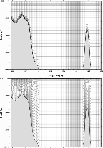
In order to draw a comparison between the performances of the above two grid schemes, we performed the so-called resting stratification experiments outlined in Wang, Yuan, Guan, Lou, and Wang (Citation2004). In conclusion, it is shown from these numerical experiments that the model with the GTF grid performs better than the conventional σ grid for this study area.
d Initialization, Forcing and Open Boundary Conditions
The in situ temperature, salinity and other parameters obtained during the September 1994 cruise were mapped onto the model grid using an objective analysis package contained in the S-Coordinate Rutgers University Model (SCRUM) software (Hedstrom, Citation1997), assuming these data were collected at the same time. Meanwhile, as required by POM, the in situ temperature was transformed into the potential temperature using the Bryden (Citation1973) polynomial for an adiabatic lapse rate and the Runge-Kutta fourth order integration algorithm. The initial condition for the flow is no motion.
The circulation model is driven by wind stress. As mentioned in Section 2a, the wind stress data were derived from NCEP reanalysis data for the survey period and were then mapped to the grids.
The bottom stresses are determined by matching the velocities at the bottommost grid point zb to a logarithmic law of the wall; thus, the drag coefficient CD is determined by
The specification of open boundary conditions is important but difficult for such a limited area. Of all the open boundary conditions, the condition for the external mode is the most important. In this study, the open boundaries for the external mode are obtained from the computational result (see Yuan et al., Citation2008b) using the modified inverse method (Yuan, Liu, Lou, Su, & Wang, Citation2004; Yuan, Su, & Pan, Citation1992), which is the same as in Wang et al. (Citation2004).
e Numerical Simulations
In this study, the numerical simulations of circulation in the areas surrounding Luzon Strait were performed in a diagnostic mode with the specified fields of T and S taken from observations. After a 60-day diagnostic spin-up, the flow field reaches a quasi-equilibrium state, which can be determined from the temporal change of the volume-averaged kinetic energy, and the diagnostic results are thus used for further analysis.
Instead of the constant mixing coefficients used in the resting stratification experiments, vertical mixing coefficients come from the turbulence closure scheme, and the horizontal mixing ones are computed using Eq. (6). A series of numerical experiments were carried out using different values of CM , for example, CM = 0.1; CM = 0.2; CM = 0.3; CM = 0.4; CM = 0.5; CM = 0.6. It was found that the model computations are sensitive to CM . When CM is smaller than 0.5, the mean kinetic energy (MKE) is unreasonably large, and when CM is greater than 0.5, the MKE becomes unreasonably small. Finally, CM = 0.5 was adopted and all the results described below were obtained using this value.
4 Model simulation results
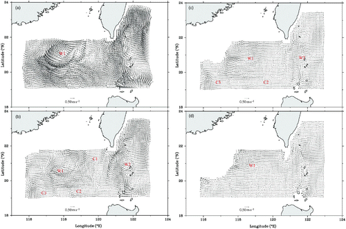
As mentioned above, the improved POM with a GTF coordinate system as well as a modified inverse method was used to study the corresponding circulation in the areas surrounding Luzon Strait during the period 28 August to 10 September 1994, on the basis of the hydrographic and wind data. The diagnostically computed results are shown in . a and 8b show the horizontal velocity distributions at the surface and 200 m depth, respectively, and and show the horizontal velocity distributions at 500 m and 1000 m depths, respectively. The circulation in the areas surrounding Luzon Strait during September 1994 is described by dividing it into two parts: the circulation system at depths above 400 m and the circulation system at depths below 400 m.
Fig. 8 Horizontal velocity distributions for diagnostic calculation at (a) the surface, (b) 200 m, (c) 500 m and (d) 1000 m depths.
a Circulation System at Depths above 400 m
In the eastern part of the computation region, the Kuroshio, which comes from the area near the eastern side of the north coast of Luzon Island, flows northwestward. In Luzon Strait the Kuroshio branches into the western and eastern (main) parts between 20°15′N and 21°00′N. The main Kuroshio makes an anticyclonic excursion and then gradually turns back, finally flowing northward into the region east of Taiwan Island, while the western branch of the Kuroshio intrudes northwestward into the SCS through Luzon Strait.
A northward current coming from the area near the western side of the north coast of Luzon Island turns and flows northwestward west of the western branch of the Kuroshio (a and 8d), which agrees with the hydrographic data analyses of Xu and Su (Citation1997) and the model results of Yuan et al. (Citation2008b). These two northwestward currents continue to intrude northwestward into the SCS through Luzon Strait and finally flow out across the northern boundary southwest of Taiwan Island (a and 8b). There are two eddies on the western branch of the Kuroshio: the anticyclonic eddy W2 on its eastern side with its centre located at about 121.5°E, 21.2°N, and the cyclonic eddy C1 on its western side. These flow features are approximately coincident with the average horizontal Argos drifter velocity distribution in September for the period 1 July 1989 to 31 June 2010 (see ), This indicates that the seasonal variation of circulation is important at depths above 400 m in Luzon Strait (e.g., Qu, Citation2000). It is worth noting that no Argos drifter velocity distribution data were available around Luzon Strait in September 1994, so we could not compare these circulation results for the same time period.
As shown in a and 8b, east of Dongsha Islands the anticyclonic eddy W1 appears between 117°E to 119°E and 20.2°N to 21.7°N. The distribution of ADCP current vectors also revealed the existence of the anticyclonic eddy W1 (). Xu and Su (Citation1997) and Yuan et al. (Citation2008b) both pointed out that the anticyclonic eddy W1 originated in the area northwest of Luzon Island. In the middle region near the southern boundary, the cyclonic eddy C2 at depths above 400 m can be seen. Cyclonic eddy C3 can be seen in the southwestern part of the model domain. Except for the area occupied by the anticyclonic eddy W1, the area west of 121°E is significantly dominated by the basin-scale cyclonic gyre which includes cyclonic eddies C1, C2 and C3 at depths above 400 m.
Fig. 9 Velocity distributions (cm s−1) from ADCP current observations at 40 m depth from 28 August to 10 September 1994 (one degree latitude corresponds to a speed of 1.5 m s−1, from Xu & Su, Citation1997 by permission).
b Circulation System at Depths below 400 m
At depths below 400 m, there is no western branch of the Kuroshio. The main Kuroshio exists at depths above 800 m (c). However, there is a southward flow instead of the Kuroshio (northward current) in the northeastern part of the computation region at the 1000 m level (d).
c and 8d reveal that the anticyclonic eddy W1 still appears east of Dongsha Islands and the cyclonic eddy C2 still exists at levels above 800 m. In the middle region near the northwestern and northern boundaries there are some northeastward and eastward flows, which turn to flow southeastward in the area southwest of Taiwan Island and finally flow eastward across Luzon Strait (c and 8d). This means that the SCS water flows eastward across Luzon Strait in the middle layers, which is in good agreement with the results of Qu (Citation2002) and Yuan et al. (Citation2008a, Citation2008b). After the intermediate layer SCS water flows eastward through the 121°E section in Luzon Strait, it turns cyclonically, then flows northward into the region east of Taiwan Island (e.g., Chen & Wang, Citation1998; Qu, Citation2002). This is qualitatively in agreement with the results of Argo trajectories at a depth of about 1000 m (see ), even though these also did not occur in the same year. This similarly indicates that the seasonal variation of circulation is important at depths below 400 m in Luzon Strait (e. g., Chen & Wang, Citation1998; Qu, Citation2002).
West of 121°E, the circulation at depths below 800 m is mainly dominated by the basin-scale anticyclonic gyre, which also agrees qualitatively with the results from Argo trajectories at a depth of about 1000 m (see ).
5 Discussion on the dynamical mechanism
As mentioned previously, there are various arguments for the mechanisms responsible for the Kuroshio intrusion, and no agreement has been reached up to now. In order to further understand the dynamical mechanism of the westward intrusion of the Kuroshio into Luzon Strait, it is necessary to compute the magnitudes of all terms in the original momentum equations. Here, only the y-direction momentum equation is selected. It is unnecessary to perform such an examination for the x-direction momentum equation, because the intrusion of the western branch of the Kuroshio into Luzon Strait is directly related to the y-direction component of the pressure gradient (e.g., Qu, Citation2000), which is just the same order of magnitude as the term –fu in Eq. (3). Two numerical experiments, Case 1 and Case 2, were performed. Case 1 is the standard experiment considering all terms such as wind, baroclinity, β-effect, and non-linearity, and the results have been described in earlier sections. The parameters and boundary conditions used in Case 2 are identical to those used in Case 1 except that a homogeneous density field is assumed; thus, baroclinicity is neglected.
In order to estimate the orders of all terms in the momentum equation and examine their roles in the westward intrusion of the Kuroshio, some ratios need to be defined:
In fact, K1, K2, K3 and K4 are, respectively, the ratios of the non-linear, pressure gradient, vertical friction and horizontal friction terms to the Coriolis term.
Discussion of dynamical mechanisms associated with numerical experiments will be expounded sequentially along the longitudinal sections 120°50′E, 120°40′E and 121°00′E south of Taiwan Island. The surface, 100 m and 200 m depths were selected to estimate the magnitudes of all terms in the y-direction momentum equation and the ratios defined in Eq. (8).
a The 120°50′E Longitudinal Section in Luzon Strait for Case 1
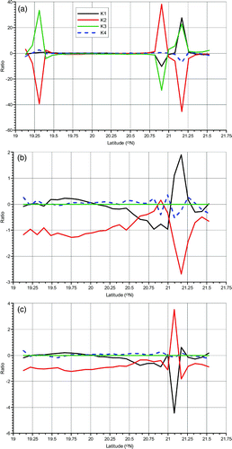
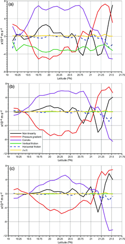
First, the magnitudes of all terms in the y-direction momentum equation and the ratios (Eq. (8)) were computed along the 120°50′E longitudinal section for Case 1. a, 10b and 10c show the variation with latitude of the magnitudes of all terms in the y-direction momentum equation along the 120°50′E section at the surface, 100 m and 200 m depths, respectively. The variations with latitude of K1, K2, K3 and K4 along the longitudinal section at the surface, 100 m and 200 m depths are plotted in . At the surface, the pressure gradient, Coriolis and vertical friction terms are of the same order of magnitude and, hence, all are main terms. However, in the area north of 20°20′N the non-linear term becomes important, and the balances among these terms seem complicated. For example, the maximum of K1 is approximately 28 around 21°10′N at the surface. At 100 m and 200 m depths, in the area south of 20°30′N the pressure gradient term is approximately balanced by the Coriolis force term and, thus, belongs to an approximate geostrophic equilibrium. In the area north of 20°30′N the non-linear term is of the same order of magnitude as other terms at these same levels. For example, the maximum of K1 is roughly 1.9 around 21°10′N at 100 m depth and is roughly −4.4 around 21°05′N at 200 m depth. These numerical results indicate that the non-linear term is important in the area north of 20°30′N along the longitudinal section 120°50′E and cannot be neglected in the momentum equation.
Fig. 10 The variation with latitude of the magnitudes of all terms in the y-direction momentum equation along the 120°50′E longitudinal section at (a) the surface, (b) 100 m and (c) 200 m depths.
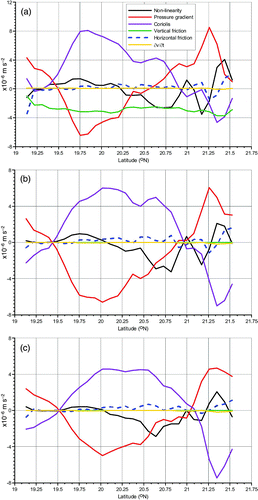
Fig. 11 The variation with latitude of K1, K2, K3 and K4 along the 120°50′E longitudinal section at (a) the surface, (b) 100 m and (c) 200 m depths.
b The 120°40′E Longitudinal Section in Luzon Strait for Case 1
The variation with latitude of the magnitudes of all the terms in the y-direction momentum equation along the 120°40′E longitudinal section at the surface, 100 m and 200 m depths is shown in for Case 1. Similar to the 120°50′E longitudinal section, the pressure gradient, Coriolis and the vertical friction terms are all principal terms at the surface and are the same order of magnitude. However, in the area north of 20°15′N the non-linear term is important and balance is achieved among more terms. For example, the maximum of K1 is approximately −9 around 20°55′N at the surface (not shown). At 100 m and 200 m depths, in the area south of 20°15′N the pressure gradient term can balance the Coriolis force term, and an approximate geostrophic equilibrium is thus reached. In the area north of 20°15′N the non-linear term is the same order of magnitude as the other terms at these same levels. For example, the maximum of K1 is approximately −2 around 20°55′N at 100 m depth and is approximately −3.6 around 20°55′N at 200 m depth, respectively (not shown). Similarly, it can be concluded that non-linear terms are important and cannot be neglected in the area north of 20°15′N along the 120°40′E section.
Fig. 12 As in except for 120°40′E.
c The 121°00′E Longitudinal Section in Luzon Strait for Case 1
For Case 1, the variation with latitude of the magnitudes of all the terms in the y-direction momentum equation along the 121°00′E longitudinal section at the surface, 100 m and 200 m depths is plotted in . As with the 120°50′E and 120°40′E longitudinal sections, at the surface all the pressure gradient, Coriolis and vertical friction terms are principal terms because they are the same order of magnitude. However, in the area north of 20°40′N the non-linear term is an important term, and balance is achieved among several terms. For example, the maximum of K1 is approximately 20 around 21°15′N at the surface (not shown). At 100 m and 200 m depths, in the area south of 20°45′N an approximate geostrophic equilibrium is reached, that is, the pressure gradient term is balanced by the Coriolis force term. In the area north of 20°45′N, the non-linear term is approximately equal to the other terms and is also important. For example, the maximum of K1 is approximately 15 around 21°15′N at 100 m depth and is approximately −7 at about 21°15′N at 200 m depths, respectively (not shown). From these numerical results, it can be seen that the non-linear terms are important and cannot be neglected in the area north of 20°45′N along the 121°00′E section.
Fig. 13 As in except for 121°00′E.
d The Longitudinal Sections in Luzon Strait for Case 2 with the Homogeneous Density Field
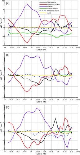
First, the magnitudes of all the terms in the y-direction momentum equation and the ratios in Eq. (8) were estimated along the 120°50′E longitudinal section for Case 2 with the homogeneous density field. a, 14b and 14c show the variation with latitude of the magnitudes of all the terms in the y-direction momentum equation along the longitudinal section at the surface, 100 m and 200 m depths, respectively, for Case 2. At the surface, both the Coriolis force term and the vertical friction term are principal terms, and the pressure gradient term is secondary, while all other terms are negligible. At 100 and 200 m depths, the pressure gradient term is approximately balanced by the Coriolis force term, that is, the geostrophic balance is dominant in the momentum equation. This indicates that the non-linear term is less and is negligible in the momentum equation for Case 2 with the homogeneous density field.
Fig. 14 As in except for Case 2 with the homogeneous density field.
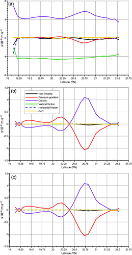
Also, the magnitudes of all terms in the y-direction momentum equation and the ratios in Eq. (8) were estimated along the 120°40′E and 121°00′E longitudinal sections for Case 2 with the homogeneous density field, and a similar conclusion was obtained (not shown).
e Comparison between Case 1 and the Linear Case
In the sense of the linear dynamics, Yuan et al. (Citation2008b) discussed the dynamical mechanism from the two-dimensional streamfunction equation obtained by vertically integrating the momentum equations, and they found that the joint effect of baroclinicity and relief (JEBAR) has an important role in affecting the circulation pattern. Yuan, Liao, and Yang (Citation2009) examined the JEBAR in more detail. In the present study, non-linear dynamics is considered, and the dynamical mechanism for the westward intrusion of the Kuroshio into Luzon Strait is discussed further from the three-dimensional primitive momentum equations. Some new findings are obtained. 1) In the surface layer (i.e., the surface Ekman layer) the pressure gradient, Coriolis force and the vertical friction terms are all principal terms and of the same order of magnitude. However, the non-linear term is important, and balance is achieved among more terms in the northern part of Luzon Strait, where the area north of 20°15′N along 120°40′E, the area north of 20°20′N along 120°50′E and the area north of 20°40′N, along 121°00′E are located. The area where the non-linearity is important expands from east to west in Luzon Strait. 2) In the subsurface layer such as at the 100 m and 200 m depths, the pressure gradient term can balance the Coriolis force term, and an approximate geostrophic equilibrium is, thus, reached in the southern part of Luzon Strait. However, the non-linear term becomes important, and the balance among these terms seem complicated in the northern part of Luzon Strait, where the area north of 20°15′N along 120°40′E, the area north of 20°30′N along 120°50′E and the area north of 20°45′N along 121°00′E are located. Similarly, the area where the non-linearity is important also expands from east to west in Luzon Strait.
In this study, a and 8b obtained using non-linear dynamics show that the Kuroshio branches into the western and eastern (main) parts in the area between 20°15′N and 21°00′N in Luzon Strait. Then, the main Kuroshio makes an anticyclonic turn and gradually turns back, finally flowing northward into the region east of Taiwan Island; a western branch of the Kuroshio intrudes northwestward through Luzon Strait into the SCS. Comparing a and 8b with a and 7b of Yuan et al. (Citation2008b), it can be seen from non-linear dynamics (Case 1) that the westward path of the Kuroshio intrusion into the northern part of Luzon Strait is more curved than with linear dynamics (Yuan et al., Citation2008b), that is to say, the non-linear term is important and cannot be neglected in the momentum equation in the northern part of Luzon Strait.
6 Summary
In order to understand the circulation in the areas surrounding Luzon Strait during September, the hydrography, wind, Argos and Argo measurements were collected and analyzed. Based on hydrographic data obtained during September 1994, an improved POM, using a GTF coordinate system as well as a modified inverse method, was used to study the corresponding circulation around Luzon Strait in September. Observations and the diagnostic simulation provide an approximately similar circulation pattern for the study domain in September. In particular, the dynamical mechanism for the westward intrusion of the Kuroshio was discussed further in Luzon Strait. A summary of the main conclusions follows.
a Observed Results
1 Main circulation features in the surface layer
| • | There are two branches of the Kuroshio. The main Kuroshio turns anticyclonically in the area southeast of Taiwan Island, then gradually turns to flow northward into the region east of Taiwan Island. A western branch of the Kuroshio intrudes northwestward through Luzon Strait into the SCS. Finally, it continues to intrude northwestward into the SCS and flows through the area southwest of Taiwan island. | ||||
| • | There is a northward current, which comes from the area west of the western coast of Luzon Island, then flows northwestward west of the intruded branch of the Kuroshio. Finally, it continues to intrude northwestward into the SCS and also flows through the area southwest of Taiwan Island. | ||||
| • | The anticyclonic eddy is seen in the area east of Dongsha Islands and its centre is located at 117.5°E, 21.1°N. | ||||
2 Main Circulation Features at about 1000 m depth from Argo Measurements
| • | An Argo drifter at 1215 m moved eastward across Luzon Strait, indicating that the SCS water flows eastward across Luzon Strait in the middle layers, which is in good agreement with the results of Qu (Citation2002) and Yuan et al. (Citation2008a, Citation2008b). | ||||
| • | In the region east of 121°E, an Argo drifter at a depth of about 1000 m moves northward, then continues to flow northward into the region east of Taiwan Island. | ||||
b Results from the Diagnostic Simulation
| • | In the eastern part of the model domain, there are two branches of the Kuroshio. The main Kuroshio exists at depths above 800 m. However, there is a southward flow instead of the Kuroshio at 1000 m depth. Another (western) branch of the Kuroshio is located at depths above 400 m and flows northwestward into the SCS through Luzon Strait and finally flows out across the northern boundary, southwest of Taiwan Island. These flow features are approximately consistent with the horizontal distribution of Argos drifter average velocities in September between 1 July 1989 and 31 June 2010, even though they did not occur in the same year. This indicates that the seasonal variation of the circulation is important at depths above 400 m in Luzon Strait. It is worth noting that no Argos drifter velocity data were available around Luzon Strait in September 1994 so that we could not compare these two circulation results directly for the same time period. | ||||
| • | At depths above 400 m east of Dongsha Islands, there is an anticyclonic eddy W1 in the area from 117°E to 119°E and 20.2°N to 21.7°N. In the middle region near the southern model boundary, the cyclonic eddy C2 appears at depths above 400 m. In the southwestern part of the model domain, a cyclonic eddy C3 can be seen. Except in the area occupied by the anticyclonic eddy W1, the area west of 121°E is dominated by the basin-scale cyclonic gyre which includes cyclonic eddies C1, C2 and C3 at depths above 400 m. | ||||
| • | At depths below 400 m, the anticyclonic eddy W1 still appears east of the Dongsha Islands and the cyclonic eddy C2 can still be seen at depths above 800 m. However, in the southwestern part of the model domain, an anticyclonic eddy occurs at depths below 800 m. In the middle region near the northwestern and northern boundaries there are some northeastward and eastward flows, which turn and flow southeastward in the area southwest of Taiwan Island and finally flow eastward across Luzon Strait. This means that the SCS water flows eastward across Luzon Strait in the middle layer then makes a cyclonic turn, finally flowing northward into the region east of Taiwan Island, which is qualitatively in agreement with the results of Argo trajectories at depths of about 1000 m. West of 121°E, the circulation at depths below 800 m is mainly dominated by the basin-scale anticyclonic gyre. This also agrees qualitatively with the results of Argo drifter trajectories at a depth of about 1000 m. | ||||
c Dynamical Mechanism
1 longitudinal sections in Luzon Strait under the baroclinicity field
| • | In the surface layer, the pressure gradient, Coriolis force and the vertical friction terms are all principal terms and of the same order of magnitude. However, the non-linear term is important, and balance is achieved among more terms in the northern part of Luzon Strait. The area where the non-linearity is important expands from east to west in Luzon Strait. | ||||
| • | In the subsurface layer, the pressure gradient term can balance the Coriolis force term, and an approximate geostrophic equilibrium is, thus, reached in the southern part of Luzon Strait. However, the non-linear term becomes important, and the balance among these terms seems complicated in the northern part of Luzon Strait. Similarly, the area where the non-linearity is important also expands from east to west in Luzon Strait. | ||||
2 longitudinal sections in Luzon Strait under the homogeneous density field
| • | The non-linear term is smaller and so negligible in the momentum equation along all the longitudinal sections in Luzon Strait for Case 2 with the homogeneous density field. | ||||
3 Comparison between the non-linear case and the linear case
| • | Comparing the non-linear case with the linear case, it can be seen that the westward path of the Kuroshio intrusion in the northern part of Luzon Strait from non-linear dynamics (Case 1) is more curved than that from linear dynamics (Yuan et al., Citation2008b), that is to say, the non-linear term is important and cannot be neglected in the momentum equation in the northern part of Luzon Strait. | ||||
Acknowledgements
This work was supported by the National Basic Research Program of China (No. 2007CB816003), the National Nature Science Foundation of China (Grant No. 41176020), the International Cooperative Project of the Ministry of Science and Technology of China (No. 2006DFB21630) and the Key project of the National Natural Science Foundation of China (No. 40520140073). We wish to thank the oceanographic data center, State Key Laboratory of Satellite Ocean Environment Dynamics, Second Institute of Oceanography, SOA, for providing the CTD and Argo data. Finally, we thank the anonymous reviewers for their valuable comments and suggestions.
Related Research Data
References
- Blumberg , A. F. and Mellor , G. L. 1987 . “ A description of a three-dimensional coastal ocean circulation model ” . In Three-dimensional coastal ocean models, coastal and estuarine science , Edited by: Heaps , N. Vol. 4 , 1 – 16 . Washington , DC : American Geophysical Union .
- Bryden , H. L. 1973 . New polynomials for thermal expansion, adiabatic temperature gradient and potential temperature of sea water . Deep-Sea Research , 20 : 401 – 408 .
- Cai , S. Q. , Liu , H. L. , Li , W. and Long , X. M. 2005 . Application of LICOM to the numerical study of the water exchange between the South China Sea and its adjacent oceans . Acta Oceanologica Sinica , 24 ( 4 ) : 10 – 19 .
- Chen , C. T. and Wang , S. L. 1998 . Influence of the intermediate water in the western Okinawa Trough by the outflow from the South China Sea . Journal of Geophysical Research , 103 : 12683 – 12688 . (doi:10.1029/98JC00366)
- ESRL (Earth System Research Laboratory). (2008). Real-time marine data [Data]. Retrieved from the NOAA, ESRL, PSD website: http://www.esrl.noaa.gov/psd/data/gridded/data.nmc.marine.html
- Fang , G. H. , Wang , Y. G. , Wei , Z. X. , Fang , Y. , Qiao , F. L. and Hu , X. M. 2009 . Interocean circulation and heat and freshwater budgets of the South China Sea based on a numerical model . Dynamics of Atmospheres and Oceans , 47 : 55 – 72 . (doi:10.1016/j.dynatmoce.2008.09.003)
- Fang , G. H. , Wei , Z. X. , Choi , B. H. , Wang , K. , Fang , Y. and Li , W. 2003 . Interbasin freshwater, heat and salt transport through the boundaries of the East and South China Seas from a variable-grid global ocean circulation model . Science In China (Series D) , 46 ( 2 ) : 149 – 161 . (doi:10.1360/03yd9014)
- Galperin , B. , Kantha , L. H. , Hasid , S. and Rosati , A. 1988 . A quasi-equilibrium turbulent energy model for geophysical flows . Journal of the Atmospheric Sciences , 45 : 55 – 62 . (doi:10.1175/1520-0469(1988)045<0055:AQETEM>2.0.CO;2)
- Hansen , D. V. and Poulain , P.-M. 1996 . Quality control and interpolations of WOCE-TOGA drifter data . Journal of Atmospheric and Oceanic Technology , 13 : 900 – 909 . (doi:10.1175/1520-0426(1996)013<0900:QCAIOW>2.0.CO;2)
- Hedstrom, K. S. (1997). User’s manual for an S-Coordinate Primitive Equation Ocean Circulation Model (SCRUM) version 3.0 (Technical Report 97-10). New Brunswick, NJ: Institute of Marine and Coastal Sciences, Rutgers University.
- Liang , W.-D. , Yang , Y. J. , Tang , T. Y. and Chung , W.-S. 2008 . Kuroshio in the Luzon Strait . Journal of Geophysical Research , 113 : C08048 doi:10.1029/2007JC004609
- Liu , Y. G. , Weisberg , R. H. and Yuan , Y. C. 2008 . Patterns of upper layer circulation variability in the South China Sea from satellite altimetry using the self-organizing map . Acta Oceanologica Sinica , 27 ( supp ) : 129 – 144 .
- Lumpkin, R., & Pazos, M. (2010). The global drifter program: What's a drifter? Retrieved from the National Oceanographic and Atmospheric Administration, Atlantic Oceanographic & Meteorological Laboratory website: http://www.aoml.noaa.gov/phod/dac/gdp_drifter.php
- Mellor , G. L. , Hakkinen , S. , Ezer , T. and Patchen , R. 2002 . “ A generalization of a sigma coordinate ocean model and an intercomparison of model vertical grids ” . In Ocean forecasting: Conceptual basis and applications , Edited by: Pinardi , N. and Woods , J. D. 55 – 722 . Berlin : Springer .
- Mellor , G. L. and Yamada , T. 1982 . Development of turbulence closure model for geophysical fluid problems . Review of Geophysics and Space Physics , 20 ( 4 ) 851, (doi:10.1029/RG020i004p00851)
- Metzger , E. J. and Hurlbert , H. E. 1996 . Coupled dynamics of the South China Sea, the Sulu Sea, and the Pacific Ocean . Journal of Geophysical Research , 101 : 12331 – 12352 . (doi:10.1029/95JC03861)
- NOAA (National Oceanic and Atmospheric Administration). (1986). ETOPO5 digital relief of the surface of the earth, Data Announcement, 86-MGG-07. National Geophysical Data Center, Washington, DC.
- Qu , T. 2000 . Upper layer circulation in the South China Sea . Journal of Physical Oceanography , 30 : 1450 – 1460 . (doi:10.1175/1520-0485(2000)030<1450:ULCITS>2.0.CO;2)
- Qu , T. D. 2002 . Evidence for water exchange between the South China Sea and the Pacific Ocean through the Luzon Strait . Acta Oceanologica Sinica , 21 ( 2 ) : 175 – 185 .
- Qu , T. , Kim , Y. Y. , Yaremchuk , M. , Tozuka , T. , Ishida , A. and Yamagata , T. 2004 . Can Luzon Strait Transport play a role in conveying the impact of ENSO to the South China Sea? . Journal of Climate , 17 : 3644 – 3657 . (doi:10.1175/1520-0442(2004)017<3644:CLSTPA>2.0.CO;2)
- Sheremet , V. A. 2001 . Hysteresis of a western boundary current leaping across a gap . Journal of Physical Oceanography , 31 : 1247 – 1259 . (doi:10.1175/1520-0485(2001)031<1247:HOAWBC>2.0.CO;2)
- Smagorinsky , J. , Manabe , S. and Holloway , J. L. 1965 . Numerical results from a nine-level general circulation model of the atmosphere . Monthly Weather Review , 93 : 727 – 768 . (doi:10.1175/1520-0493(1965)093<0727:NRFANL>2.3.CO;2)
- Song , Y. T. and Haidvogel , D. 1994 . A semi-implicit ocean circulation model using a generalized topography following coordinate system . Journal of Computational Physics , 115 : 228 – 244 . (doi:10.1006/jcph.1994.1189)
- Stommel , H. and Arons , A. B. 1960 . On the abyssal circulation of the world ocean. I: Stationary planetary flow patterns on a sphere . Deep-Sea Research , 6 : 140 – 154 .
- Wang , H. , Yuan , Y. , Guan , W. , Lou , R. and Wang , K. 2004 . Circulation in the South China Sea during summer 2000 as obtained from observations and a generalized topography-following ocean model . Journal of Geophysical Research , 109 : C07007 doi:10.1029/2003JC002134
- Xu , J. P. and Su , J. L. 1997 . Hydrographic analysis on the intrusion of Kuroshio into the South China Sea-II. Observational results during the cruise from August to September in 1994 . Tropic Oceanology , 16 ( 2 ) : 1 – 23 . (in Chinese with English abstract)
- Yuan , D. , Han , W. and Hu , D. 2006 . Surface Kuroshio path in the Luzon Strait area derived from satellite remote sensing data . Journal of Geophysical Research , 111 : C11007 doi:10.1029/2005JC00341
- Yuan , D. L. , Han , W. Q. and Hu , D. X. 2007 . Anti-cyclonic eddies northwest of Luzon in summer–fall observed by satellite altimeters . Geophysical Research Letters , 34 : L13610 doi:10.1029 /2007GL029401
- Yuan , Y. C. , Liao , G. H. , Guan , W. B. , Wang , H. Q. , Lou , R. Y. and Chen , H. 2008a . The circulation in the upper and middle layers of the Luzon Strait during spring 2002 . Journal of Geophysical Research , 113 : C06004 doi:10.1029/2007JC004546
- Yuan , Y. C. , Liao , G. H. and Yang , C. H. 2008b . The Kuroshio near the Luzon Strait and circulation in the northern South China Sea during August and September 1994 . Journal of Oceanography , 64 ( 5 ) : 777 – 788 . (doi:10.1007/s10872-008-0065-6)
- Yuan , Y. C. , Liao , G. H. and Yang , C. H. 2009 . A diagnostic calculation of the circulation in the upper and middle layers of the Luzon Strait and the northern South China Sea during March 1992 . Dynamics of Atmospheres and Oceans , 47 : 86 – 113 . (doi:10.1016/j.dynatmoce.2008.10.005)
- Yuan , Y. C. , Liu , Y. G. , Lou , R. Y. , Su , J. L. and Wang , K. S. 2004 . Calculation of circulation in the South China Sea during summer of 2000 by the modified inverse method . Acta Oceanologica Sinica , 26 ( 1 ) : 1 – 13 .
- Yuan , Y. C. , Su , J. L. and Pan , Z. Q. 1992 . Volume and heat transports of the Kuroshio in the East China Sea in 1989 . La mer , 30 : 251 – 262 .